Bridge Statistics for Holladay, Utah (UT)
Condition, Traffic, Stress, Structural Evaluation, Project Costs
- National Bridge Inventory (NBI) Statistics
- 20Number of bridges
- 157ft / 47.8mTotal length
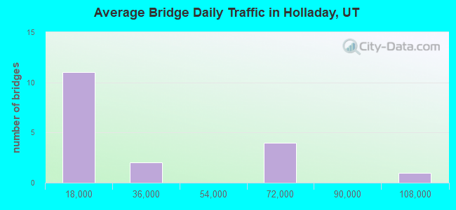
- 438,709Total average daily traffic
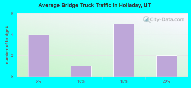
- 50,368Total average daily truck traffic
- National Bridge Inventory (NBI) Registered Bridges for Holladay
- No street view available for this location

- New bridges - historical statistics
- 31930-1939
- 31940-1949
- 11960-1969
- 91980-1989
- 22000-2009
- 22020-2022
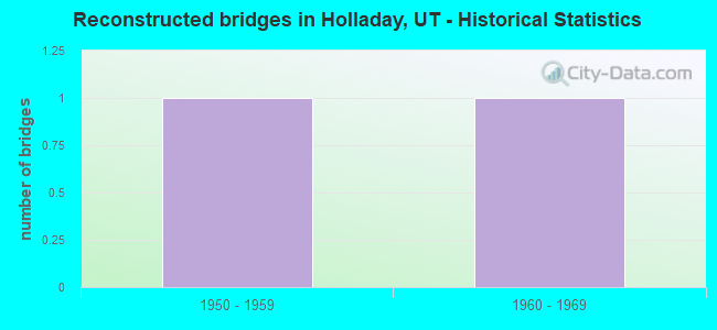
- Reconstructed bridges - Historical Statistics
- 11950-1959
- 11960-1969
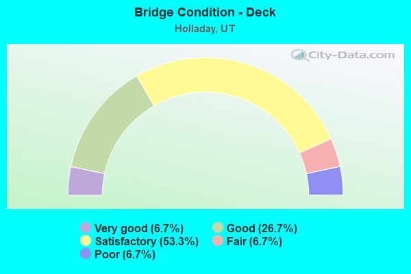
- Bridge Condition - Deck
- 6.7%Very good
- 26.7%Good
- 53.3%Satisfactory
- 6.7%Fair
- 6.7%Poor
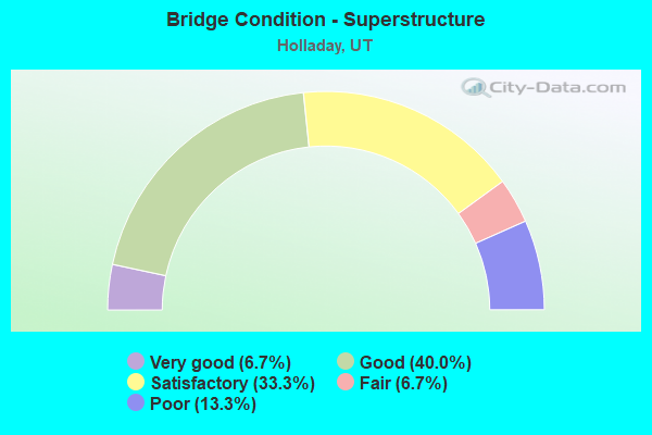
- Bridge Condition - Superstructure
- 6.7%Very good
- 40.0%Good
- 33.3%Satisfactory
- 6.7%Fair
- 13.3%Poor
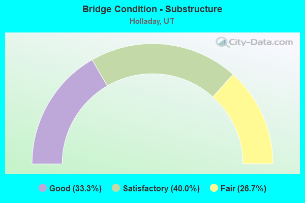
- Bridge Condition - Substructure
- 33.3%Good
- 40.0%Satisfactory
- 26.7%Fair
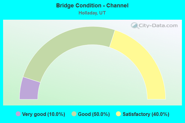
- Bridge Condition - Channel
- 10.0%Very good
- 50.0%Good
- 40.0%Satisfactory
Find on map >> Show street view
Structure Number: 35062C, Location: 4750 SO.1750 E., SL.CO. (Lat: 40.665000, Lng: -111.840075), Route carried "on" structure: County highway , Year Built: 1981, Status: Open, Structure Length: 1.44m (4.72ft), Average Daily Traffic: 1,021 (year 2020), Truck Traffic: 1%, Average Future Daily Traffic: 1,240 (year 2040), Design Load: HS 20+Mod, Features Intersected: BIG COTTONWOOD CREEK, Facility Carried by Structure: HIGHLAND CIRCLE
Minimum Vertical Clearance: 30+ m (98+ ft), Kilometerpoint: 0.039, Lanes on structure: 2, Owner: City or Municipal Highway Agency, Approaching Roadway Width: 11.6m (38.1ft), Skew: 15 degrees, Material/Design: Steel, Design/Construction: Stringer/Multi-beam, Number Of Spans In Main Unit: 1, Length of Maximum Span: 13.3m (43.6ft), Curb-To-Curb Width: 4.1m (13.5ft), Out-to-Out Width: 9.8m (32.2ft)
Condition: Deck: Fair, Superstructure: Satisfactory, Substructure: Satisfactory, Channel: Good, Operating Rating: 40.2 metric tons, Method Used To Determine Operating Rating: Load and Resistance Factor Rating (LRFR) rating reported by rating factor(RF) method using HL-93 loadings, Inventory Rating: 34.3 metric tons, Method Used To Determine Inventory Rating: Load and Resistance Factor Rating (LRFR) rating reported by rating factor(RF) method using HL-93 loadings, Structural Evaluation: Equal to present minimum criteria, Deck Geometry: High priority of replacement, Waterway Adequacy: Equal to present minimum criteria, Approach Roadway Alignment: Meets minimum limits, Designated Inspection Frequency: Every 24 months, Inspection Date: December 2021, Deck Structure Type: Concrete Cast-file-Place, Wearing Surface/Protective System: Wearing Surface: Monolithic Concrete
Find on map >> Show street view
Structure Number: 35064D, Location: 5250 SO.2350 E.,HOLLADAY (Lat: 40.656167, Lng: -111.824019), Route carried "on" structure: City street 2184, Year Built: 1940, Status: Open, Structure Length: 0.82m (2.69ft), Average Daily Traffic: 500 (year 2020), Average Future Daily Traffic: 625 (year 2040), Design Load: HL 93, Features Intersected: BIG COTTONWOOD CREEK, Facility Carried by Structure: COTTONWOOD LANE
Minimum Vertical Clearance: 30.18m (99.02ft), Kilometerpoint: 1.242, Lanes on structure: 2, Owner: City or Municipal Highway Agency, Approaching Roadway Width: 9.8m (32.2ft), Skew: 1 degrees, Material/Design: Concrete, Design/Construction: Tee Beam, Number Of Spans In Main Unit: 1, Length of Maximum Span: 7.8m (25.6ft), Curb-To-Curb Width: 17.7m (58.1ft), Out-to-Out Width: 19.2m (63.0ft)
Condition: Deck: Satisfactory, Superstructure: Satisfactory, Substructure: Fair, Channel: Satisfactory, Operating Rating: 32.4 metric tons, Method Used To Determine Operating Rating: Load and Resistance Factor Rating (LRFR) rating reported by rating factor(RF) method using HL-93 loadings, Inventory Rating: 20.1 metric tons, Method Used To Determine Inventory Rating: Load Factor (LF) rating reported by rating factor (RF) method using MS18 loading, Structural Evaluation: Somewhat better than minimum adequacy, Deck Geometry: Superior to present desirable criteria, Waterway Adequacy: Better than present minimum criteria, Approach Roadway Alignment: Equal to present desirable criteria, Designated Inspection Frequency: Every 24 months, Inspection Date: December 2021, Deck Structure Type: Concrete Cast-file-Place, Wearing Surface/Protective System: Wearing Surface: Bituminous
Find on map >> Show street view
Structure Number: 35065D, Location: 2025 E.5450 SO.,HOLLADAY (Lat: 40.652053, Lng: -111.834339), Route carried "on" structure: City street 2184, Year Built: 1938, Status: Posted for load, Structure Length: 0.85m (2.79ft), Average Daily Traffic: 500 (year 2020), Average Future Daily Traffic: 625 (year 2040), Design Load: HL 93, Features Intersected: JORDAN SALT LAKE CANAL, Facility Carried by Structure: WALKER LANE
Minimum Vertical Clearance: 30+ m (98+ ft), Kilometerpoint: 0.052, Lanes on structure: 2, Owner: City or Municipal Highway Agency, Approaching Roadway Width: 11.9m (39.0ft), Skew: 3 degrees, Material/Design: Concrete, Design/Construction: Tee Beam, Number Of Spans In Main Unit: 1, Length of Maximum Span: 7.6m (24.9ft), Curb-To-Curb Width: 11.9m (39.0ft), Out-to-Out Width: 13.5m (44.3ft)
Condition: Deck: Satisfactory, Superstructure: Fair, Substructure: Satisfactory, Channel: Satisfactory, Operating Rating: 32.4 metric tons, Method Used To Determine Operating Rating: Load and Resistance Factor Rating (LRFR) rating reported by rating factor(RF) method using HL-93 loadings, Inventory Rating: 19.8 metric tons, Method Used To Determine Inventory Rating: Load Factor (LF) rating reported by rating factor (RF) method using MS18 loading, Structural Evaluation: Somewhat better than minimum adequacy, Deck Geometry: Better than present minimum criteria, Waterway Adequacy: Better than present minimum criteria, Approach Roadway Alignment: Equal to present desirable criteria, Designated Inspection Frequency: Every 24 months, Inspection Date: December 2021, Deck Structure Type: Concrete Cast-file-Place, Wearing Surface/Protective System: Wearing Surface: Bituminous
Find on map >> Show street view
Structure Number: 35066D, Location: 4850 SO.1850 E.,HOLLADAY (Lat: 40.663711, Lng: -111.838750), Route carried "on" structure: City street 2266, Year Built: 1936, Year Reconstructed: 1964, Status: Posted for load, Structure Length: 1.14m (3.74ft), Average Daily Traffic: 18,276 (year 2020), Average Future Daily Traffic: 22,845 (year 2040), Design Load: HS 20, Features Intersected: BIG COTTONWOOD CREEK, Facility Carried by Structure: HIGHLAND DRIVE
Minimum Vertical Clearance: 30+ m (98+ ft), Kilometerpoint: 2.715, Lanes on structure: 4, Owner: City or Municipal Highway Agency, Approaching Roadway Width: 23.3m (76.4ft), Skew: 24 degrees, Material/Design: Concrete, Design/Construction: Tee Beam, Number Of Spans In Main Unit: 1, Length of Maximum Span: 10.1m (33.1ft), Curb or Sidewalk Widths: Left: 1.6m (5.2ft), Right: 0.6m (2.0ft), Curb-To-Curb Width: 23.3m (76.4ft), Out-to-Out Width: 26.8m (87.9ft)
Condition: Deck: Satisfactory, Superstructure: Poor, Substructure: Fair, Channel: Good, Operating Rating: 31.1 metric tons, Method Used To Determine Operating Rating: Load Factor (LF) rating reported by rating factor (RF) method using MS18 loading, Inventory Rating: 19.1 metric tons, Method Used To Determine Inventory Rating: Load Factor (LF) rating reported by rating factor (RF) method using MS18 loading, Structural Evaluation: Meets minimum limits, Deck Geometry: Superior to present desirable criteria, Waterway Adequacy: Equal to present minimum criteria, Approach Roadway Alignment: Equal to present desirable criteria, Bridge Posting: Required (Relationship of Operating Rating to Maximum Legal Load: 0.1 - 9.9% below), Designated Inspection Frequency: Every 24 months, Inspection Date: December 2021, Deck Structure Type: Concrete Cast-file-Place, Wearing Surface/Protective System: Wearing Surface: Bituminous
Find on map >> Show street view
Structure Number: 35067C, Location: 6400 SO. HOLLADAY BLVD. (Lat: 40.635444, Lng: -111.811472), Route carried "on" structure: City street , Year Built: 1989, Status: Open, Structure Length: 1.80m (5.91ft), Average Daily Traffic: 252 (year 2020), Truck Traffic: 1%, Average Future Daily Traffic: 306 (year 2040), Design Load: HS 20+Mod, Features Intersected: BIG COTTONWOOD CREEK, Facility Carried by Structure: HOLLADAY BOULEVARD
Minimum Vertical Clearance: 30+ m (98+ ft), Kilometerpoint: 0.000, Lanes on structure: 1, Owner: City or Municipal Highway Agency, Approaching Roadway Width: 10.0m (32.8ft), Skew: 3 degrees, Material/Design: Steel, Design/Construction: Stringer/Multi-beam, Number Of Spans In Main Unit: 1, Length of Maximum Span: 17.1m (56.1ft), Curb-To-Curb Width: 10.0m (32.8ft), Out-to-Out Width: 11.0m (36.1ft)
Condition: Deck: Satisfactory, Superstructure: Very good, Substructure: Good, Channel: Good, Operating Rating: 74.5 metric tons, Method Used To Determine Operating Rating: Load and Resistance Factor Rating (LRFR) rating reported by rating factor(RF) method using HL-93 loadings, Inventory Rating: 55.1 metric tons, Method Used To Determine Inventory Rating: Load Factor (LF) rating reported by rating factor (RF) method using MS18 loading, Structural Evaluation: Better than present minimum criteria, Deck Geometry: Better than present minimum criteria, Waterway Adequacy: Better than present minimum criteria, Approach Roadway Alignment: High priority of corrective action, Designated Inspection Frequency: Every 24 months, Inspection Date: December 2021, Deck Structure Type: Concrete Cast-file-Place, Wearing Surface/Protective System: Wearing Surface: Monolithic Concrete, Deck Protection: Epoxy Coated Reinforcing
Find on map >> Show street view
Structure Number: 35068D, Location: 2050 E.5000 SO.,HOLLADAY (Lat: 40.660308, Lng: -111.833008), Route carried "on" structure: City street , Year Built: 1945, Status: Open, Structure Length: 0.79m (2.59ft), Average Daily Traffic: 1,021 (year 2020), Truck Traffic: 1%, Average Future Daily Traffic: 1,240 (year 2040), Design Load: HL 93, Features Intersected: BIG COTTONWOOD CREEK, Facility Carried by Structure: ARBOR LN.(5000 SO)
Minimum Vertical Clearance: 30+ m (98+ ft), Kilometerpoint: 0.185, Lanes on structure: 2, Owner: City or Municipal Highway Agency, Approaching Roadway Width: 7.3m (24.0ft), Material/Design: Concrete, Design/Construction: Slab, Number Of Spans In Main Unit: 1, Length of Maximum Span: 6.6m (21.7ft), Curb-To-Curb Width: 7.3m (24.0ft), Out-to-Out Width: 9.9m (32.5ft)
Condition: Deck: Satisfactory, Superstructure: Satisfactory, Substructure: Satisfactory, Channel: Satisfactory, Operating Rating: 33.0 metric tons, Method Used To Determine Operating Rating: Load and Resistance Factor Rating (LRFR) rating reported by rating factor(RF) method using HL-93 loadings, Inventory Rating: 19.8 metric tons, Method Used To Determine Inventory Rating: Load Factor (LF) rating reported by rating factor (RF) method using MS18 loading, Structural Evaluation: Somewhat better than minimum adequacy, Deck Geometry: Meets minimum limits, Waterway Adequacy: Meets minimum limits, Approach Roadway Alignment: Equal to present minimum criteria, Designated Inspection Frequency: Every 24 months, Inspection Date: December 2021, Deck Structure Type: Concrete Cast-file-Place, Wearing Surface/Protective System: Wearing Surface: Bituminous
Find on map >> Show street view
Structure Number: 35069D, Location: 2800 E. 6200 SO.,HOLLADAY (Lat: 40.637806, Lng: -111.812989), Route carried "on" structure: City street 2158, Year Built: 1935, Status: Posted for load, Structure Length: 0.85m (2.79ft), Average Daily Traffic: 8,589 (year 2020), Average Future Daily Traffic: 10,736 (year 2040), Design Load: HL 93, Features Intersected: BIG COTTONWOOD CREEK, Facility Carried by Structure: 6200 SOUTH STREET
Minimum Vertical Clearance: 30+ m (98+ ft), Kilometerpoint: 1.852, Lanes on structure: 2, Owner: City or Municipal Highway Agency, Approaching Roadway Width: 14.0m (45.9ft), Material/Design: Concrete, Design/Construction: Tee Beam, Number Of Spans In Main Unit: 1, Length of Maximum Span: 6.7m (22.0ft), Curb-To-Curb Width: 14.0m (45.9ft), Out-to-Out Width: 15.2m (49.9ft)
Condition: Deck: Satisfactory, Superstructure: Satisfactory, Substructure: Fair, Channel: Good, Operating Rating: 32.4 metric tons, Method Used To Determine Operating Rating: Load and Resistance Factor Rating (LRFR) rating reported by rating factor(RF) method using HL-93 loadings, Inventory Rating: 19.4 metric tons, Method Used To Determine Inventory Rating: Load Factor (LF) rating reported by rating factor (RF) method using MS18 loading, Structural Evaluation: Meets minimum limits, Deck Geometry: Superior to present desirable criteria, Waterway Adequacy: Equal to present minimum criteria, Approach Roadway Alignment: Equal to present minimum criteria, Bridge Posting: Required (Relationship of Operating Rating to Maximum Legal Load: 20.0 - 29.9% below), Designated Inspection Frequency: Every 24 months, Inspection Date: December 2021, Deck Structure Type: Concrete Cast-file-Place, Wearing Surface/Protective System: Wearing Surface: Bituminous
Find on map >> Show street view
Structure Number: 35110D, Location: 4820 S.1665 E., HOLLADAY (Lat: 40.664778, Lng: -111.844614), Route carried "on" structure: City street , Year Built: 1965, Status: Open, Structure Length: 0.80m (2.62ft), Average Daily Traffic: 1,890 (year 2020), Truck Traffic: 1%, Average Future Daily Traffic: 2,296 (year 2040), Design Load: HS 20+Mod, Features Intersected: BIG COTTONWOOD CREEK, Facility Carried by Structure: KINGS ROW DRIVE
Minimum Vertical Clearance: 30+ m (98+ ft), Kilometerpoint: 0.036, Lanes on structure: 2, Owner: City or Municipal Highway Agency, Approaching Roadway Width: 13.7m (44.9ft), Skew: 2 degrees, Material/Design: Concrete, Design/Construction: Frame, Number Of Spans In Main Unit: 1, Length of Maximum Span: 7.1m (23.3ft), Curb or Sidewalk Widths: Left: 3.0m (9.8ft), Right: 3.0m (9.8ft), Curb-To-Curb Width: 13.7m (44.9ft), Out-to-Out Width: 22.3m (73.2ft)
Condition: Deck: Satisfactory, Superstructure: Satisfactory, Substructure: Good, Channel: Good, Operating Rating: 34.0 metric tons, Method Used To Determine Operating Rating: Load Factor (LF) rating reported by rating factor (RF) method using MS18 loading, Inventory Rating: 11.3 metric tons, Method Used To Determine Inventory Rating: Load and Resistance Factor Rating (LRFR) rating reported by rating factor(RF) method using HL-93 loadings, Structural Evaluation: High priority of corrective action, Deck Geometry: Superior to present desirable criteria, Waterway Adequacy: Better than present minimum criteria, Approach Roadway Alignment: Equal to present desirable criteria, Designated Inspection Frequency: Every 24 months, Inspection Date: December 2021, Deck Structure Type: Concrete Cast-file-Place, Wearing Surface/Protective System: Wearing Surface: Bituminous
Find on map >> Show street view
Structure Number: 35131D, Location: 1900 E. 5600 SO., SL.CO. (Lat: 40.649392, Lng: -111.837333), Route carried "on" structure: County highway 2122, Year Built: 1940, Year Reconstructed: 1960, Status: Open, Structure Length: 0.77m (2.53ft), Average Daily Traffic: 6,523 (year 2020), Average Future Daily Traffic: 8,154 (year 2040), Design Load: HL 93, Features Intersected: JORDAN SALT LAKE CANAL, Facility Carried by Structure: 5600 SOUTH STREET
Minimum Vertical Clearance: 30+ m (98+ ft), Kilometerpoint: 4.342, Lanes on structure: 2, Owner: City or Municipal Highway Agency, Approaching Roadway Width: 13.4m (44.0ft), Skew: 3 degrees, Material/Design: Concrete, Design/Construction: Tee Beam, Number Of Spans In Main Unit: 1, Length of Maximum Span: 7.0m (23.0ft), Curb-To-Curb Width: 13.4m (44.0ft), Out-to-Out Width: 20.1m (65.9ft)
Condition: Deck: Poor, Superstructure: Poor, Substructure: Fair, Channel: Satisfactory, Operating Rating: 32.4 metric tons, Method Used To Determine Operating Rating: Load and Resistance Factor Rating (LRFR) rating reported by rating factor(RF) method using HL-93 loadings, Inventory Rating: 19.4 metric tons, Method Used To Determine Inventory Rating: Load Factor (LF) rating reported by rating factor (RF) method using MS18 loading, Structural Evaluation: Meets minimum limits, Deck Geometry: Equal to present minimum criteria, Waterway Adequacy: Better than present minimum criteria, Approach Roadway Alignment: Equal to present desirable criteria, Designated Inspection Frequency: Every 24 months, Other Special Inspection Frequency: Every 12 months, Inspection Date: December 2021, Other Special Inspection Date: December 2021, Deck Structure Type: Concrete Cast-file-Place, Wearing Surface/Protective System: Wearing Surface: Bituminous
Find on map >> Show street view
Structure Number: C 757, Location: KNUDSON'S CORNER (Lat: 40.638206, Lng: -111.808511), Route carried "on" structure: Interstate 215, Year Built: 1989, Status: Open, Structure Length: 14.17m (46.49ft), Average Daily Traffic: 60,831 (year 2020), Truck Traffic: 11%, Average Future Daily Traffic: 76,039 (year 2040), Design Load: HS 20+Mod, Features Intersected: SR-190
Minimum Vertical Clearance: 30+ m (98+ ft), Kilometerpoint: 10.014, Lanes on structure: 6, Lanes under structure: 4, Base Highway Network: Yes, Owner: State Highway Agency, Approaching Roadway Width: 34.1m (111.9ft), Skew: 1 degrees, Material/Design: Steel continuous, Design/Construction: Stringer/Multi-beam, Number Of Spans In Main Unit: 3, Length of Maximum Span: 64.6m (211.9ft), Curb-To-Curb Width: 35.9m (117.8ft), Out-to-Out Width: 37.9m (124.3ft)
Condition: Deck: Good, Superstructure: Good, Substructure: Good, Operating Rating: 51.2 metric tons, Method Used To Determine Operating Rating: Load and Resistance Factor Rating (LRFR) rating reported by rating factor(RF) method using HL-93 loadings, Inventory Rating: 31.4 metric tons, Method Used To Determine Inventory Rating: Load and Resistance Factor Rating (LRFR) rating reported by rating factor(RF) method using HL-93 loadings, Structural Evaluation: Better than present minimum criteria, Deck Geometry: Superior to present desirable criteria, Underclear: Equal to present desirable criteria, Approach Roadway Alignment: Equal to present desirable criteria, Designated Inspection Frequency: Every 24 months, Inspection Date: September 2020, Deck Structure Type: Concrete Cast-file-Place, Wearing Surface/Protective System: Wearing Surface: Epoxy Overlay, Deck Protection: Epoxy Coated Reinforcing
Find on map >> Show street view
Structure Number: C 953, Location: 4430 South Wasatch Blv. (Lat: 40.674603, Lng: -111.802986), Route carried "on" structure: State highway 266, Year Built: 2007, Status: Open, Structure Length: 5.34m (17.52ft), Average Daily Traffic: 14,915 (year 2020), Truck Traffic: 7%, Average Future Daily Traffic: 18,644 (year 2040), Design Load: HL 93, Features Intersected: I-215, (SR-215)
Minimum Vertical Clearance: 30+ m (98+ ft), Kilometerpoint: 12.961, Lanes on structure: 4, Lanes under structure: 6, Base Highway Network: Yes, Owner: State Highway Agency, Approaching Roadway Width: 19.8m (65.0ft), Material/Design: Steel, Design/Construction: Stringer/Multi-beam, Number Of Spans In Main Unit: 1, Length of Maximum Span: 52.5m (172.2ft), Curb or Sidewalk Widths: Left: 1.8m (5.9ft), Right: 1.8m (5.9ft), Curb-To-Curb Width: 20.6m (67.6ft), Out-to-Out Width: 25.1m (82.3ft)
Condition: Deck: Satisfactory, Superstructure: Good, Substructure: Good, Operating Rating: 56.4 metric tons, Method Used To Determine Operating Rating: Load and Resistance Factor Rating (LRFR) rating reported by rating factor(RF) method using HL-93 loadings, Inventory Rating: 37.3 metric tons, Method Used To Determine Inventory Rating: Load and Resistance Factor Rating (LRFR) rating reported by rating factor(RF) method using HL-93 loadings, Structural Evaluation: Better than present minimum criteria, Deck Geometry: Superior to present desirable criteria, Underclear: High priority of corrective action, Approach Roadway Alignment: Equal to present desirable criteria, Designated Inspection Frequency: Every 24 months, Inspection Date: September 2020, Deck Structure Type: Concrete Cast-file-Place, Wearing Surface/Protective System: Wearing Surface: Epoxy Overlay, Deck Protection: Epoxy Coated Reinforcing
Find on map >> Show street view
Structure Number: F 458, Location: 5800 SOUTH and I-215 (Lat: 40.646139, Lng: -111.808517), Route carried "on" structure: Interstate 215, Year Built: 1989, Status: Open, Structure Length: 4.34m (14.24ft), Average Daily Traffic: 60,831 (year 2020), Truck Traffic: 11%, Average Future Daily Traffic: 76,039 (year 2040), Design Load: HS 20+Mod, Features Intersected: 5800 SOUTH STREET
Minimum Vertical Clearance: 30+ m (98+ ft), Kilometerpoint: 9.131, Lanes on structure: 6, Lanes under structure: 2, Base Highway Network: Yes, Owner: State Highway Agency, Approaching Roadway Width: 34.1m (111.9ft), Material/Design: Prestressed concrete, Design/Construction: Stringer/Multi-beam, Number Of Spans In Main Unit: 1, Length of Maximum Span: 42.7m (140.1ft), Curb-To-Curb Width: 36.0m (118.1ft), Out-to-Out Width: 38.0m (124.7ft)
Condition: Deck: Good, Superstructure: Good, Substructure: Satisfactory, Operating Rating: 74.8 metric tons, Method Used To Determine Operating Rating: Load and Resistance Factor Rating (LRFR) rating reported by rating factor(RF) method using HL-93 loadings, Inventory Rating: 30.1 metric tons, Method Used To Determine Inventory Rating: Load Factor (LF) rating reported by rating factor (RF) method using MS18 loading, Structural Evaluation: Equal to present minimum criteria, Deck Geometry: Superior to present desirable criteria, Underclear: Superior to present desirable criteria, Approach Roadway Alignment: Equal to present desirable criteria, Designated Inspection Frequency: Every 24 months, Inspection Date: September 2020, Deck Structure Type: Concrete Cast-file-Place, Wearing Surface/Protective System: Wearing Surface: Epoxy Overlay, Deck Protection: Epoxy Coated Reinforcing
Find on map >> Show street view
Structure Number: F 505, Location: 6400 SO. 2300 EAST (Lat: 40.634042, Lng: -111.824717), Route carried "on" structure: County highway 2226, Year Built: 1988, Status: Open, Structure Length: 7.38m (24.21ft), Average Daily Traffic: 12,081 (year 2020), Average Future Daily Traffic: 15,101 (year 2040), Design Load: HS 20+Mod, Features Intersected: I-215 (SR-215) EBL &, Facility Carried by Structure: 2300 EAST STREET
Minimum Vertical Clearance: 30+ m (98+ ft), Kilometerpoint: 2.328, Lanes on structure: 2, Lanes under structure: 6, Owner: State Highway Agency, Approaching Roadway Width: 12.8m (42.0ft), Material/Design: Prestressed concrete continuous, Design/Construction: Stringer/Multi-beam, Number Of Spans In Main Unit: 2, Length of Maximum Span: 39.3m (128.9ft), Curb or Sidewalk Widths: Left: 1.4m (4.6ft), Right: 1.4m (4.6ft), Curb-To-Curb Width: 13.7m (44.9ft), Out-to-Out Width: 17.6m (57.7ft)
Condition: Deck: Good, Superstructure: Good, Substructure: Satisfactory, Operating Rating: 41.5 metric tons, Method Used To Determine Operating Rating: Load and Resistance Factor Rating (LRFR) rating reported by rating factor(RF) method using HL-93 loadings, Inventory Rating: 31.1 metric tons, Method Used To Determine Inventory Rating: Load and Resistance Factor Rating (LRFR) rating reported by rating factor(RF) method using HL-93 loadings, Structural Evaluation: Equal to present minimum criteria, Deck Geometry: Superior to present desirable criteria, Underclear: Equal to present minimum criteria, Approach Roadway Alignment: Equal to present desirable criteria, Designated Inspection Frequency: Every 24 months, Inspection Date: September 2020, Deck Structure Type: Concrete Cast-file-Place, Wearing Surface/Protective System: Wearing Surface: Bituminous, Deck Protection: Epoxy Coated Reinforcing
Find on map >> Show street view
Structure Number: 4C 76, Location: .2 MI.SW.KNUDSON CNR.INT (Lat: 40.635592, Lng: -111.811050), Route carried "on" structure: Ramp Interstate 215, Year Built: 1989, Status: Open, Structure Length: 5.20m (17.06ft), Average Daily Traffic: 25,500 (year 2020), Truck Traffic: 15%, Average Future Daily Traffic: 31,875 (year 2040), Design Load: HS 20+Mod, Features Intersected: HLDY.BLVD.& BIG CTWD
Minimum Vertical Clearance: 30+ m (98+ ft), Kilometerpoint: 0.324, Lanes on structure: 2, Lanes under structure: 2, Owner: State Highway Agency, Approaching Roadway Width: 10.4m (34.1ft), Skew: 2 degrees, Material/Design: Steel, Design/Construction: Stringer/Multi-beam, Number Of Spans In Main Unit: 1, Length of Maximum Span: 48.8m (160.1ft), Curb-To-Curb Width: 11.8m (38.7ft), Out-to-Out Width: 12.8m (42.0ft)
Condition: Deck: Good, Superstructure: Good, Substructure: Satisfactory, Channel: Very good, Operating Rating: 97.2 metric tons, Method Used To Determine Operating Rating: Load and Resistance Factor Rating (LRFR) rating reported by rating factor(RF) method using HL-93 loadings, Inventory Rating: 79.1 metric tons, Method Used To Determine Inventory Rating: Load and Resistance Factor Rating (LRFR) rating reported by rating factor(RF) method using HL-93 loadings, Structural Evaluation: Equal to present minimum criteria, Deck Geometry: Superior to present desirable criteria, Underclear: Meets minimum limits, Waterway Adequacy: Equal to present desirable criteria, Approach Roadway Alignment: Equal to present desirable criteria, Designated Inspection Frequency: Every 24 months, Inspection Date: September 2020, Deck Structure Type: Concrete Cast-file-Place, Wearing Surface/Protective System: Wearing Surface: Monolithic Concrete, Membrane: Epoxy, Deck Protection: Epoxy Coated Reinforcing
Find on map >> Show street view
Structure Number: C1092, Location: I-80 Temp over 2300 (Lat: 40.713047, Lng: -111.822433), Route carried "on" structure: Interstate 80, Year Built: 2021, Status: Temporarily open, Structure Length: 2.13m (6.99ft), Average Daily Traffic: 90,775 (year 2020), Truck Traffic: 18%, Average Future Daily Traffic: 113,469 (year 2040), Design Load: HL 93, Features Intersected: 2300 East Temp
Minimum Vertical Clearance: 30+ m (98+ ft), Kilometerpoint: 204.031, Lanes on structure: 2, Lanes under structure: 2, Base Highway Network: Yes, Owner: State Highway Agency, Approaching Roadway Width: 8.2m (26.9ft), Skew: 1 degrees, Material/Design: Steel, Design/Construction: Stringer/Multi-beam, Number Of Spans In Main Unit: 1, Length of Maximum Span: 20.5m (67.3ft), Curb-To-Curb Width: 9.3m (30.5ft), Out-to-Out Width: 9.3m (30.5ft)
Condition: Deck: Very good, Superstructure: Good, Substructure: Good, Structural Evaluation: High priority of corrective action, Deck Geometry: High priority of replacement, Underclear: Somewhat better than minimum adequacy, Approach Roadway Alignment: Equal to present desirable criteria, Designated Inspection Frequency: Every 24 months, Inspection Date: December 2021, Deck Structure Type: Concrete Cast-file-Place, Wearing Surface/Protective System: Deck Protection: Epoxy Coated Reinforcing
Find on map >> Show street view
Structure Number: C 757, Location: KNUDSON'S CORNER (Lat: 40.638206, Lng: -111.808511), Route carried "under" structure: State highway 190, Year Built: 1989, Structure Length: 0. m, Average Daily Traffic: 12,311 (year 2020), Truck Traffic: 13%, Features Intersected: SR-190, Facility Carried by Structure: I-215 (SR-215)
Minimum Vertical Clearance: 5.26m (17.26ft), Kilometerpoint: 0.129, Lanes on structure: 6, Lanes under structure: 4, Material/Design: Steel continuous, Design/Construction: Stringer/Multi-beam, Length of Maximum Span: 64.6m (211.9ft)
Find on map >> Show street view
Structure Number: C 953, Location: 4430 South Wasatch Blv. (Lat: 40.674603, Lng: -111.802986), Route carried "under" structure: Interstate 215, Year Built: 2007, Structure Length: 0. m, Average Daily Traffic: 60,831 (year 2020), Truck Traffic: 11%, Features Intersected: I-215, (SR-215), Facility Carried by Structure: SR-266,4300 SO.ST.
Minimum Vertical Clearance: 5.33m (17.49ft), Kilometerpoint: 5.921, Lanes on structure: 4, Lanes under structure: 6, Material/Design: Steel, Design/Construction: Stringer/Multi-beam, Length of Maximum Span: 52.5m (172.2ft)
Find on map >> Show street view
Structure Number: F 505, Location: 6400 SO. 2300 EAST (Lat: 40.634042, Lng: -111.824717), Route carried "under" structure: Interstate 215, Year Built: 1988, Structure Length: 0. m, Average Daily Traffic: 62,062 (year 2020), Truck Traffic: 12%, Features Intersected: I-215 (SR-215) EBL &, Facility Carried by Structure: 2300 EAST STREET
Minimum Vertical Clearance: 5.49m (18.01ft), Kilometerpoint: 11.632, Lanes on structure: 2, Lanes under structure: 6, Material/Design: Prestressed concrete continuous, Design/Construction: Stringer/Multi-beam, Length of Maximum Span: 39.3m (128.9ft)
Find on map >> Show street view
Structure Number: 4C 76, Location: .2 MI.SW.KNUDSON CNR.INT (Lat: 40.635592, Lng: -111.811050), Route carried "under" structure: County highway , Year Built: 1989, Structure Length: 0. m, Features Intersected: HLDY.BLVD.& BIG CTWD, Facility Carried by Structure: I-215 WB.ON-RAMP
Minimum Vertical Clearance: 4.98m (16.34ft), Kilometerpoint: 0.000, Lanes on structure: 2, Lanes under structure: 2, Material/Design: Steel, Design/Construction: Stringer/Multi-beam, Length of Maximum Span: 48.8m (160.1ft)
Find on map >> Show street view
Structure Number: C1092, Location: I-80 Temp over 2300 (Lat: 40.713047, Lng: -111.822433), Route carried "under" structure: Ramp City street 195, Year Built: 2021, Structure Length: 0. m, Features Intersected: 2300 East Temp, Facility Carried by Structure: I-80
Minimum Vertical Clearance: 5.06m (16.60ft), Kilometerpoint: 0.000, Lanes on structure: 2, Lanes under structure: 2, Material/Design: Steel, Design/Construction: Stringer/Multi-beam, Length of Maximum Span: 20.5m (67.3ft)