Bridge Statistics for Holland, Michigan (MI)
Condition, Traffic, Stress, Structural Evaluation, Project Costs
- National Bridge Inventory (NBI) Statistics
- 45Number of bridges
- 358ft / 109mTotal length
- $604,000Total costs
- 424,992Total average daily traffic
- 57,895Total average daily truck traffic
- National Bridge Inventory (NBI) Registered Bridges for Holland
- No street view available for this location
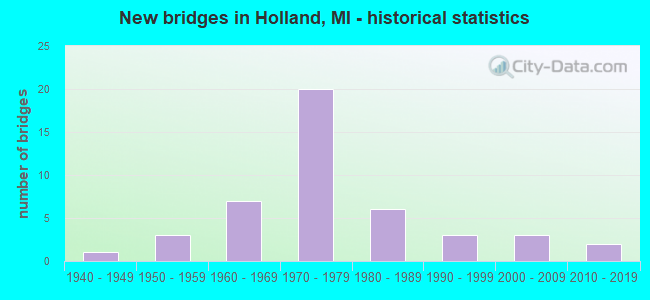
- New bridges - historical statistics
- 11940-1949
- 31950-1959
- 71960-1969
- 201970-1979
- 61980-1989
- 31990-1999
- 32000-2009
- 22010-2019
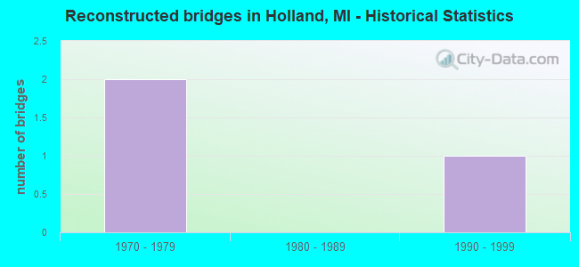
- Reconstructed bridges - Historical Statistics
- 21970-1979
- 01980-1989
- 11990-1999
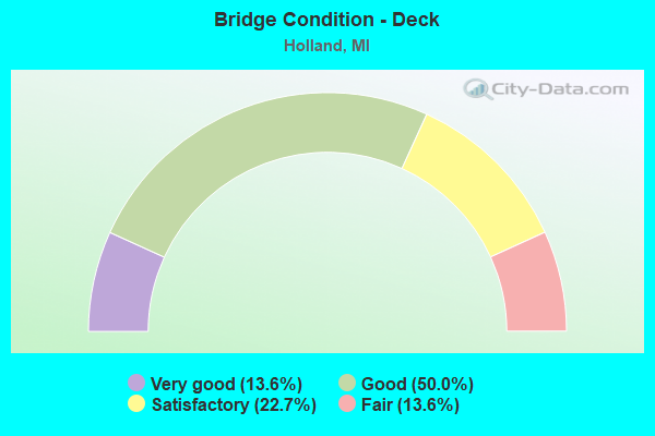
- Bridge Condition - Deck
- 13.6%Very good
- 50.0%Good
- 22.7%Satisfactory
- 13.6%Fair
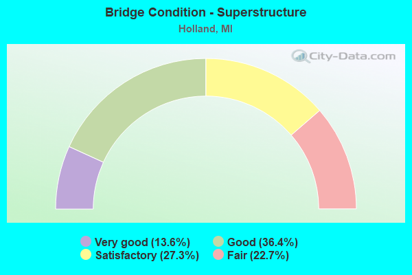
- Bridge Condition - Superstructure
- 13.6%Very good
- 36.4%Good
- 27.3%Satisfactory
- 22.7%Fair
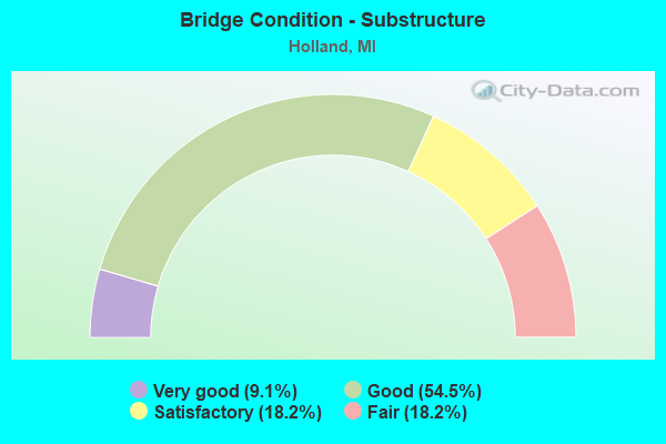
- Bridge Condition - Substructure
- 9.1%Very good
- 54.5%Good
- 18.2%Satisfactory
- 18.2%Fair
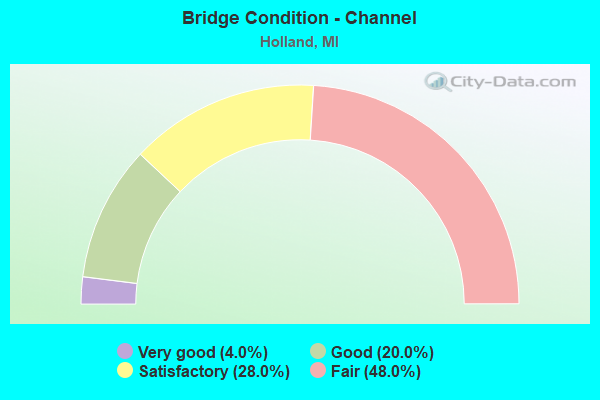
- Bridge Condition - Channel
- 4.0%Very good
- 20.0%Good
- 28.0%Satisfactory
- 48.0%Fair
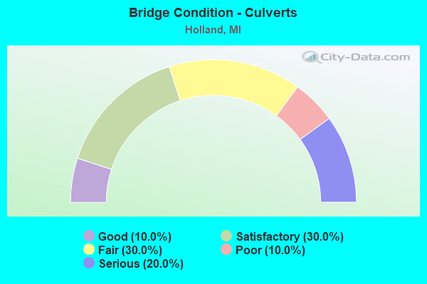
- Bridge Condition - Culverts
- 10.0%Good
- 30.0%Satisfactory
- 30.0%Fair
- 10.0%Poor
- 20.0%Serious
Find on map >> Show street view
Structure Number: 96, Location: S LTS OF HOLLAND (Lat: 42.748692, Lng: -86.118692), Route carried "on" structure: US 31, Year Built: 2011, Status: Open, Structure Length: 2.77m (9.09ft), Average Daily Traffic: 6,350 (year 2011), Truck Traffic: 5%, Average Future Daily Traffic: 7,800 (year 2031), Design Load: HL 93, Features Intersected: N BR MACATAWA RIVER
Minimum Vertical Clearance: 30.48m (100.00ft), Kilometerpoint: 1.215, Lanes on structure: 4, Base Highway Network: Yes (Inventory Route: 303, Subroute: 48), Owner: State Highway Agency, Approaching Roadway Width: 21.9m (71.9ft), Material/Design: Prestressed concrete, Design/Construction: Stringer/Multi-beam, Number Of Spans In Main Unit: 1, Length of Maximum Span: 26.8m (87.9ft), Curb-To-Curb Width: 21.9m (71.9ft), Out-to-Out Width: 22.7m (74.5ft)
Condition: Deck: Good, Superstructure: Satisfactory, Substructure: Good, Channel: Good, Operating Rating: 68.0 metric tons, Method Used To Determine Operating Rating: Load and Resistance Factor Rating (LRFR) rating reported by rating factor(RF) method using HL-93 loadings, Inventory Rating: 39.5 metric tons, Method Used To Determine Inventory Rating: Load and Resistance Factor Rating (LRFR) rating reported by rating factor(RF) method using HL-93 loadings, Structural Evaluation: Equal to present minimum criteria, Deck Geometry: Better than present minimum criteria, Waterway Adequacy: Equal to present minimum criteria, Approach Roadway Alignment: Equal to present minimum criteria, Designated Inspection Frequency: Every 24 months, Inspection Date: May 2021, Deck Structure Type: Concrete Cast-file-Place, Wearing Surface/Protective System: Wearing Surface: Monolithic Concrete, Deck Protection: Epoxy Coated Reinforcing
Find on map >> Show street view
Structure Number: 1, Location: AT 144TH AVENUE & 60TH ST (Lat: 42.739311, Lng: -86.135989), Route carried "on" structure: US 31, Year Built: 1963, Status: Open, Structure Length: 0.68m (2.23ft), Average Daily Traffic: 17,204 (year 2007), Truck Traffic: 8%, Average Future Daily Traffic: 25,585 (year 2018), Design Load: HS 20+Mod, Features Intersected: N BR MACATAWA RIVER
Minimum Vertical Clearance: 30.48m (100.00ft), Kilometerpoint: 1.428, Lanes on structure: 4, Base Highway Network: Yes (Inventory Route: 79, Subroute: 6), Owner: State Highway Agency, Approaching Roadway Width: 24.4m (80.1ft), Skew: 2 degrees, Material/Design: Concrete, Design/Construction: Culvert, Number Of Spans In Main Unit: 2, Length of Maximum Span: 3.3m (10.8ft)
Condition: Channel: Fair, Culverts: Satisfactory, Operating Rating: 54.8 metric tons, Method Used To Determine Operating Rating: Load Factor (LF) rating reported by rating factor (RF) method using MS18 loading, Inventory Rating: 32.7 metric tons, Method Used To Determine Inventory Rating: Load Factor (LF) rating reported by rating factor (RF) method using MS18 loading, Structural Evaluation: Equal to present minimum criteria, Waterway Adequacy: Equal to present minimum criteria, Approach Roadway Alignment: Equal to present desirable criteria, Designated Inspection Frequency: Every 24 months, Inspection Date: March 2021, Wearing Surface/Protective System: Wearing Surface: Bituminous
Find on map >> Show street view
Structure Number: 102, Location: IN HOLLAND (Lat: 42.749933, Lng: -86.119372), Route carried "on" structure: Business US 31, Year Built: 1964, Status: Open, Structure Length: 5.67m (18.60ft), Average Daily Traffic: 17,386 (year 2007), Truck Traffic: 1%, Average Future Daily Traffic: 31,192 (year 2018), Design Load: HS 20+Mod, Features Intersected: US-31 NB
Minimum Vertical Clearance: 30.48m (100.00ft), Kilometerpoint: 1.368, Lanes on structure: 3, Lanes under structure: 2, Base Highway Network: Yes (Inventory Route: 303, Subroute: 48), Owner: State Highway Agency, Approaching Roadway Width: 20.3m (66.6ft), Skew: 24 degrees, Material/Design: Steel, Design/Construction: Stringer/Multi-beam, Number Of Spans In Main Unit: 3, Length of Maximum Span: 25.0m (82.0ft), Curb or Sidewalk Widths: Left: 0.1m (0.3ft), Right: 0.1m (0.3ft), Curb-To-Curb Width: 19.1m (62.7ft), Out-to-Out Width: 20.0m (65.6ft)
Condition: Deck: Fair, Superstructure: Fair, Substructure: Fair, Operating Rating: 67.4 metric tons, Method Used To Determine Operating Rating: Load Factor (LF), Inventory Rating: 40.4 metric tons, Method Used To Determine Inventory Rating: Load Factor (LF), Structural Evaluation: Somewhat better than minimum adequacy, Deck Geometry: Superior to present desirable criteria, Underclear: Somewhat better than minimum adequacy, Approach Roadway Alignment: Somewhat better than minimum adequacy, Length Of Structure Improvement: 5.67m (18.60ft), Designated Inspection Frequency: Every 24 months, Inspection Date: May 2021, Bridge Improvement Cost: $363,000, Roadway Improvement Cost: $32,000, Total Project Cost: $372,000, Deck Structure Type: Concrete Cast-file-Place, Wearing Surface/Protective System: Wearing Surface: Monolithic Concrete
Find on map >> Show street view
Structure Number: 103, Location: IN HOLLAND (Lat: 42.753969, Lng: -86.116264), Route carried "on" structure: US 31, Year Built: 1964, Status: Open, Structure Length: 5.81m (19.06ft), Average Daily Traffic: 8,602 (year 2007), Truck Traffic: 9%, Average Future Daily Traffic: 11,096 (year 2018), Design Load: HS 20+Mod, Features Intersected: US-31 BR (58 TH STREET)
Minimum Vertical Clearance: 30.48m (100.00ft), Kilometerpoint: 3.686, Lanes on structure: 2, Lanes under structure: 3, Base Highway Network: Yes (Inventory Route: 79, Subroute: 4), Owner: State Highway Agency, Approaching Roadway Width: 12.8m (42.0ft), Skew: 4 degrees, Material/Design: Steel, Design/Construction: Stringer/Multi-beam, Number Of Spans In Main Unit: 3, Length of Maximum Span: 30.8m (101.0ft), Curb or Sidewalk Widths: Left: 0.2m (0.7ft), Right: 0.2m (0.7ft), Curb-To-Curb Width: 12.0m (39.4ft), Out-to-Out Width: 13.1m (43.0ft)
Condition: Deck: Satisfactory, Superstructure: Fair, Substructure: Fair, Operating Rating: 60.9 metric tons, Method Used To Determine Operating Rating: Load Factor (LF) rating reported by rating factor (RF) method using MS18 loading, Inventory Rating: 36.3 metric tons, Method Used To Determine Inventory Rating: Load Factor (LF) rating reported by rating factor (RF) method using MS18 loading, Structural Evaluation: Somewhat better than minimum adequacy, Deck Geometry: Equal to present minimum criteria, Underclear: High priority of corrective action, Approach Roadway Alignment: Better than present minimum criteria, Designated Inspection Frequency: Every 24 months, Inspection Date: May 2021, Deck Structure Type: Concrete Cast-file-Place, Wearing Surface/Protective System: Wearing Surface: Monolithic Concrete
Find on map >> Show street view
Structure Number: 126, Location: 1.3 MI SW OF OTTAWA COL (Lat: 42.747486, Lng: -86.066622), Route carried "on" structure: Interstate 196, Year Built: 1972, Status: Open, Structure Length: 4.26m (13.98ft), Average Daily Traffic: 9,123 (year 2007), Truck Traffic: 32%, Average Future Daily Traffic: 8,394 (year 2018), Design Load: HS 20, Features Intersected: CSX RR
Minimum Vertical Clearance: 30.48m (100.00ft), Kilometerpoint: 44.318, Lanes on structure: 3, Base Highway Network: Yes (Inventory Route: 78, Subroute: 8), Owner: State Highway Agency, Approaching Roadway Width: 12.2m (40.0ft), Material/Design: Prestressed concrete, Design/Construction: Stringer/Multi-beam, Number Of Spans In Main Unit: 3, Length of Maximum Span: 14.3m (46.9ft), Curb-To-Curb Width: 13.7m (44.9ft), Out-to-Out Width: 14.7m (48.2ft)
Condition: Deck: Satisfactory, Superstructure: Fair, Substructure: Satisfactory, Operating Rating: 78.1 metric tons, Method Used To Determine Operating Rating: Load Factor (LF) rating reported by rating factor (RF) method using MS18 loading, Inventory Rating: 46.7 metric tons, Method Used To Determine Inventory Rating: Load Factor (LF) rating reported by rating factor (RF) method using MS18 loading, Structural Evaluation: Somewhat better than minimum adequacy, Deck Geometry: High priority of corrective action, Underclear: Superior to present desirable criteria, Approach Roadway Alignment: Equal to present desirable criteria, Designated Inspection Frequency: Every 24 months, Inspection Date: May 2021, Deck Structure Type: Concrete Cast-file-Place, Wearing Surface/Protective System: Wearing Surface: Monolithic Concrete
Find on map >> Show street view
Structure Number: 127, Location: 6.6 MI SW OF OTTAWA COL (Lat: 42.732936, Lng: -86.143486), Route carried "on" structure: Interstate 196, Year Built: 1972, Status: Open, Structure Length: 7.62m (25.00ft), Average Daily Traffic: 6,333 (year 2007), Truck Traffic: 29%, Average Future Daily Traffic: 7,500 (year 2015), Design Load: HS 20, Features Intersected: US-31 NB
Minimum Vertical Clearance: 30.48m (100.00ft), Kilometerpoint: 37.583, Lanes on structure: 2, Lanes under structure: 2, Base Highway Network: Yes (Inventory Route: 78, Subroute: 8), Owner: State Highway Agency, Approaching Roadway Width: 14.2m (46.6ft), Skew: 5 degrees, Material/Design: Steel, Design/Construction: Stringer/Multi-beam, Number Of Spans In Main Unit: 3, Length of Maximum Span: 36.6m (120.1ft), Curb-To-Curb Width: 12.3m (40.4ft), Out-to-Out Width: 13.4m (44.0ft)
Condition: Deck: Satisfactory, Superstructure: Satisfactory, Substructure: Satisfactory, Operating Rating: 93.3 metric tons, Method Used To Determine Operating Rating: Load Factor (LF) rating reported by rating factor (RF) method using MS18 loading, Inventory Rating: 55.7 metric tons, Method Used To Determine Inventory Rating: Load Factor (LF) rating reported by rating factor (RF) method using MS18 loading, Structural Evaluation: Equal to present minimum criteria, Deck Geometry: Better than present minimum criteria, Underclear: Equal to present minimum criteria, Approach Roadway Alignment: Better than present minimum criteria, Designated Inspection Frequency: Every 5 months, Inspection Date: December 2021, Deck Structure Type: Concrete Cast-file-Place, Wearing Surface/Protective System: Wearing Surface: Latex Concrete, Deck Protection: Epoxy Coated Reinforcing
Find on map >> Show street view
Structure Number: 13, Location: 3.9 MI SW OF OTTAWA COL (Lat: 42.736758, Lng: -86.096003), Route carried "on" structure: County highway , Year Built: 1972, Status: Open, Structure Length: 7.71m (25.30ft), Average Daily Traffic: 1,819 (year 1997), Truck Traffic: 2%, Average Future Daily Traffic: 2,092 (year 2017), Design Load: H 20, Features Intersected: I-196, Facility Carried by Structure: 56 TH STREET
Minimum Vertical Clearance: 30.48m (100.00ft), Kilometerpoint: 6.082, Lanes on structure: 2, Lanes under structure: 4, Owner: State Highway Agency, Approaching Roadway Width: 10.1m (33.1ft), Material/Design: Steel continuous, Design/Construction: Stringer/Multi-beam, Number Of Spans In Main Unit: 2, Length of Maximum Span: 37.9m (124.3ft), Curb or Sidewalk Widths: Left: 0.2m (0.7ft), Right: 0.2m (0.7ft), Curb-To-Curb Width: 12.3m (40.4ft), Out-to-Out Width: 13.6m (44.6ft)
Condition: Deck: Satisfactory, Superstructure: Good, Substructure: Good, Operating Rating: 63.5 metric tons, Method Used To Determine Operating Rating: Load Factor (LF) rating reported by rating factor (RF) method using MS18 loading, Inventory Rating: 37.9 metric tons, Method Used To Determine Inventory Rating: Load Factor (LF) rating reported by rating factor (RF) method using MS18 loading, Structural Evaluation: Better than present minimum criteria, Deck Geometry: Better than present minimum criteria, Underclear: Somewhat better than minimum adequacy, Approach Roadway Alignment: Better than present minimum criteria, Designated Inspection Frequency: Every 24 months, Inspection Date: May 2021, Deck Structure Type: Concrete Cast-file-Place, Wearing Surface/Protective System: Wearing Surface: Monolithic Concrete
Find on map >> Show street view
Structure Number: 131, Location: 1.4 MI SW OF OTTAWA COL (Lat: 42.743811, Lng: -86.071714), Route carried "on" structure: State highway 40, Year Built: 1972, Status: Open, Structure Length: 7.44m (24.41ft), Average Daily Traffic: 11,124 (year 2007), Truck Traffic: 11%, Average Future Daily Traffic: 12,802 (year 2018), Design Load: HS 20, Features Intersected: I-196
Minimum Vertical Clearance: 30.48m (100.00ft), Kilometerpoint: 31.086, Lanes on structure: 2, Lanes under structure: 4, Base Highway Network: Yes (Inventory Route: 78, Subroute: 9), Owner: State Highway Agency, Approaching Roadway Width: 16.2m (53.1ft), Material/Design: Steel, Design/Construction: Stringer/Multi-beam, Number Of Spans In Main Unit: 2, Length of Maximum Span: 37.8m (124.0ft), Curb-To-Curb Width: 14.2m (46.6ft), Out-to-Out Width: 15.5m (50.9ft)
Condition: Deck: Fair, Superstructure: Satisfactory, Substructure: Fair, Operating Rating: 94.3 metric tons, Method Used To Determine Operating Rating: Load Factor (LF) rating reported by rating factor (RF) method using MS18 loading, Inventory Rating: 56.4 metric tons, Method Used To Determine Inventory Rating: Load Factor (LF) rating reported by rating factor (RF) method using MS18 loading, Structural Evaluation: Somewhat better than minimum adequacy, Deck Geometry: Superior to present desirable criteria, Underclear: Somewhat better than minimum adequacy, Approach Roadway Alignment: Better than present minimum criteria, Designated Inspection Frequency: Every 24 months, Inspection Date: May 2021, Deck Structure Type: Concrete Cast-file-Place, Wearing Surface/Protective System: Wearing Surface: Monolithic Concrete
Find on map >> Show street view
Structure Number: 133, Location: AT OTTAWA CO LINE (Lat: 42.768936, Lng: -86.036114), Route carried "on" structure: Interstate 196, Year Built: 1972, Status: Open, Structure Length: 3.69m (12.11ft), Average Daily Traffic: 9,123 (year 2007), Truck Traffic: 27%, Average Future Daily Traffic: 7,500 (year 2015), Design Load: HS 20, Features Intersected: OTTOGAN STREET
Minimum Vertical Clearance: 30.48m (100.00ft), Kilometerpoint: 47.712, Lanes on structure: 2, Lanes under structure: 2, Base Highway Network: Yes (Inventory Route: 78, Subroute: 7), Owner: State Highway Agency, Approaching Roadway Width: 11.6m (38.1ft), Skew: 3 degrees, Material/Design: Steel, Design/Construction: Stringer/Multi-beam, Number Of Spans In Main Unit: 1, Length of Maximum Span: 36.9m (121.1ft), Curb-To-Curb Width: 12.7m (41.7ft), Out-to-Out Width: 13.7m (44.9ft)
Condition: Deck: Satisfactory, Superstructure: Satisfactory, Substructure: Fair, Operating Rating: 77.8 metric tons, Method Used To Determine Operating Rating: Load Factor (LF) rating reported by rating factor (RF) method using MS18 loading, Inventory Rating: 46.7 metric tons, Method Used To Determine Inventory Rating: Load Factor (LF) rating reported by rating factor (RF) method using MS18 loading, Structural Evaluation: Somewhat better than minimum adequacy, Deck Geometry: Better than present minimum criteria, Underclear: Somewhat better than minimum adequacy, Approach Roadway Alignment: Equal to present desirable criteria, Length Of Structure Improvement: 3.69m (12.11ft), Designated Inspection Frequency: Every 24 months, Inspection Date: May 2021, Bridge Improvement Cost: $101,000, Roadway Improvement Cost: $5,000, Total Project Cost: $63,000, Deck Structure Type: Concrete Cast-file-Place, Wearing Surface/Protective System: Wearing Surface: Monolithic Concrete
Find on map >> Show street view
Structure Number: 14, Location: 2.4 MI SE OF OTTAWA COL (Lat: 42.747108, Lng: -86.075044), Route carried "on" structure: State highway 40, Year Built: 1999, Status: Open, Structure Length: 1.66m (5.45ft), Average Daily Traffic: 6,433 (year 2007), Truck Traffic: 24%, Average Future Daily Traffic: 9,422 (year 2018), Design Load: HS 25 or greater, Features Intersected: N BR MACATAWA RIVER
Minimum Vertical Clearance: 30.48m (100.00ft), Kilometerpoint: 31.543, Lanes on structure: 5, Base Highway Network: Yes (Inventory Route: 78, Subroute: 9), Owner: State Highway Agency, Approaching Roadway Width: 19.5m (64.0ft), Material/Design: Prestressed concrete, Design/Construction: Box Beam or Girders - Single/Spread, Number Of Spans In Main Unit: 1, Length of Maximum Span: 16.6m (54.5ft), Curb-To-Curb Width: 24.0m (78.7ft), Out-to-Out Width: 25.0m (82.0ft)
Condition: Deck: Good, Superstructure: Good, Substructure: Good, Channel: Satisfactory, Operating Rating: 61.2 metric tons, Method Used To Determine Operating Rating: Load Factor (LF) rating reported by rating factor (RF) method using MS18 loading, Inventory Rating: 33.4 metric tons, Method Used To Determine Inventory Rating: Load Factor (LF) rating reported by rating factor (RF) method using MS18 loading, Structural Evaluation: Better than present minimum criteria, Deck Geometry: Equal to present desirable criteria, Waterway Adequacy: Equal to present desirable criteria, Approach Roadway Alignment: Equal to present desirable criteria, Designated Inspection Frequency: Every 24 months, Inspection Date: May 2021, Deck Structure Type: Concrete Cast-file-Place, Wearing Surface/Protective System: Wearing Surface: Epoxy Overlay, Deck Protection: Epoxy Coated Reinforcing
Find on map >> Show street view
Structure Number: 183, Location: APPROX 0.25 MI W OF 52ND (Lat: 42.718533, Lng: -86.063481), Route carried "on" structure: County highway 382, Year Built: 2009, Status: Open, Structure Length: 0.91m (2.99ft), Average Daily Traffic: 1,800 (year 2008), Truck Traffic: 7%, Average Future Daily Traffic: 3,251 (year 2028), Design Load: HL 93, Features Intersected: KLEINHEKSEL DRAIN, Facility Carried by Structure: 141ST AVE
Minimum Vertical Clearance: 30.48m (100.00ft), Kilometerpoint: 6.755, Lanes on structure: 2, Owner: County Highway Agency, Approaching Roadway Width: 12.2m (40.0ft), Skew: 4 degrees, Material/Design: Concrete, Design/Construction: Culvert, Number Of Spans In Main Unit: 1, Length of Maximum Span: 9.1m (29.9ft), Curb-To-Curb Width: 12.2m (40.0ft), Out-to-Out Width: 15.2m (49.9ft)
Condition: Channel: Good, Culverts: Good, Operating Rating: 57.7 metric tons, Method Used To Determine Operating Rating: Load and Resistance Factor Rating (LRFR) rating reported by rating factor(RF) method using HL-93 loadings, Inventory Rating: 44.7 metric tons, Method Used To Determine Inventory Rating: Load and Resistance Factor Rating (LRFR) rating reported by rating factor(RF) method using HL-93 loadings, Structural Evaluation: Better than present minimum criteria, Deck Geometry: Better than present minimum criteria, Waterway Adequacy: Better than present minimum criteria, Approach Roadway Alignment: Equal to present desirable criteria, Designated Inspection Frequency: Every 24 months, Inspection Date: October 2021, Wearing Surface/Protective System: Wearing Surface: Bituminous
Find on map >> Show street view
Structure Number: 189, Location: APPROX 0.25 MI W OF 48TH (Lat: 42.754650, Lng: -86.024086), Route carried "on" structure: County highway 386, Year Built: 1972, Status: Posted for load, Structure Length: 1.14m (3.74ft), Average Daily Traffic: 2,504 (year 2010), Truck Traffic: 7%, Average Future Daily Traffic: 4,103 (year 2030), Design Load: HS 20+Mod, Features Intersected: S BR MACATAWA RIVER, Facility Carried by Structure: 146TH AVE
Minimum Vertical Clearance: 30.48m (100.00ft), Kilometerpoint: 0.544, Lanes on structure: 2, Owner: County Highway Agency, Approaching Roadway Width: 10.4m (34.1ft), Material/Design: Steel, Design/Construction: Culvert, Number Of Spans In Main Unit: 3, Length of Maximum Span: 2.7m (8.9ft)
Condition: Channel: Fair, Culverts: Serious, Operating Rating: 18.8 metric tons, Method Used To Determine Operating Rating: Load Factor (LF) rating reported by rating factor (RF) method using MS18 loading, Inventory Rating: 11.3 metric tons, Method Used To Determine Inventory Rating: Load Factor (LF) rating reported by rating factor (RF) method using MS18 loading, Structural Evaluation: High priority of corrective action, Waterway Adequacy: Equal to present minimum criteria, Approach Roadway Alignment: Equal to present desirable criteria, Bridge Posting: Required (Relationship of Operating Rating to Maximum Legal Load: 0.1 - 9.9% below), Designated Inspection Frequency: Every 12 months, Inspection Date: October 2021
Find on map >> Show street view
Structure Number: 242, Location: APPROX 1/4 MI E OF 50TH (Lat: 42.740147, Lng: -86.029869), Route carried "on" structure: County highway , Year Built: 1973, Status: Open, Structure Length: 1.22m (4.00ft), Average Daily Traffic: 286 (year 2002), Truck Traffic: 7%, Average Future Daily Traffic: 572 (year 2022), Design Load: H 20, Features Intersected: ESKES DRAIN, Facility Carried by Structure: 144TH AVE
Minimum Vertical Clearance: 30.48m (100.00ft), Kilometerpoint: 1.465, Lanes on structure: 2, Owner: County Highway Agency, Approaching Roadway Width: 9.1m (29.9ft), Material/Design: Steel, Design/Construction: Culvert, Number Of Spans In Main Unit: 3, Length of Maximum Span: 3.3m (10.8ft)
Condition: Channel: Fair, Culverts: Fair, Operating Rating: 27.2 metric tons, Method Used To Determine Operating Rating: Load Factor (LF) rating reported by rating factor (RF) method using MS18 loading, Inventory Rating: 16.2 metric tons, Method Used To Determine Inventory Rating: Load Factor (LF) rating reported by rating factor (RF) method using MS18 loading, Structural Evaluation: Somewhat better than minimum adequacy, Waterway Adequacy: Equal to present desirable criteria, Approach Roadway Alignment: Equal to present desirable criteria, Designated Inspection Frequency: Every 24 months, Inspection Date: May 2021
Find on map >> Show street view
Structure Number: 243, Location: FILLMORE TWP SEC 14 (Lat: 42.736778, Lng: -86.042186), Route carried "on" structure: County highway , Year Built: 1981, Status: Open, Structure Length: 1.08m (3.54ft), Average Daily Traffic: 141 (year 2002), Truck Traffic: 7%, Average Future Daily Traffic: 282 (year 2022), Design Load: H 20, Features Intersected: S BR MACATAWA RIVER, Facility Carried by Structure: RUSSCHER ROAD
Minimum Vertical Clearance: 30.48m (100.00ft), Kilometerpoint: 1.540, Lanes on structure: 2, Owner: County Highway Agency, Approaching Roadway Width: 6.7m (22.0ft), Material/Design: Steel, Design/Construction: Culvert, Number Of Spans In Main Unit: 2, Length of Maximum Span: 4.8m (15.7ft)
Condition: Channel: Fair, Culverts: Serious, Operating Rating: 24.0 metric tons, Method Used To Determine Operating Rating: Load Factor (LF) rating reported by rating factor (RF) method using MS18 loading, Inventory Rating: 14.3 metric tons, Method Used To Determine Inventory Rating: Load Factor (LF) rating reported by rating factor (RF) method using MS18 loading, Structural Evaluation: High priority of corrective action, Waterway Adequacy: Equal to present desirable criteria, Approach Roadway Alignment: Equal to present desirable criteria, Designated Inspection Frequency: Every 12 months, Inspection Date: May 2021
Find on map >> Show street view
Structure Number: 265, Location: APPROX 3/8MI S OF 144TH A (Lat: 42.735556, Lng: -86.146064), Route carried "on" structure: County highway , Year Built: 2004, Status: Open, Structure Length: 1.17m (3.84ft), Average Daily Traffic: 116 (year 2005), Truck Traffic: 7%, Average Future Daily Traffic: 232 (year 2025), Design Load: HS 20+Mod, Features Intersected: KUIPERS DRAIN, Facility Carried by Structure: 61ST STREET
Minimum Vertical Clearance: 30.48m (100.00ft), Kilometerpoint: 0.016, Lanes on structure: 2, Owner: County Highway Agency, Approaching Roadway Width: 7.3m (24.0ft), Skew: 4 degrees, Material/Design: Concrete, Design/Construction: Culvert, Number Of Spans In Main Unit: 2, Length of Maximum Span: 4.3m (14.1ft)
Condition: Channel: Fair, Culverts: Satisfactory, Operating Rating: 43.4 metric tons, Method Used To Determine Operating Rating: Field evaluation and documented engineering judgment, Inventory Rating: 32.7 metric tons, Method Used To Determine Inventory Rating: Field evaluation and documented engineering judgment, Structural Evaluation: Equal to present minimum criteria, Waterway Adequacy: Equal to present desirable criteria, Approach Roadway Alignment: Equal to present desirable criteria, Designated Inspection Frequency: Every 24 months, Inspection Date: May 2021
Find on map >> Show street view
Structure Number: 318, Location: IN HOLLAND (Lat: 42.749678, Lng: -86.096558), Route carried "on" structure: City street , Year Built: 1986, Status: Open, Structure Length: 1.12m (3.67ft), Average Daily Traffic: 2,482 (year 1996), Truck Traffic: 2%, Average Future Daily Traffic: 4,482 (year 2017), Design Load: HS 20, Features Intersected: N BR BLACK RIVER, Facility Carried by Structure: LINCOLN AVE
Minimum Vertical Clearance: 30.48m (100.00ft), Kilometerpoint: 7.855, Lanes on structure: 2, Owner: City or Municipal Highway Agency, Approaching Roadway Width: 8.5m (27.9ft), Material/Design: Prestressed concrete, Design/Construction: Box Beam or Girders - Multiple, Number Of Spans In Main Unit: 1, Length of Maximum Span: 10.0m (32.8ft), Curb-To-Curb Width: 13.4m (44.0ft), Out-to-Out Width: 14.1m (46.3ft)
Condition: Deck: Good, Superstructure: Good, Substructure: Very good, Channel: Satisfactory, Operating Rating: 62.9 metric tons, Method Used To Determine Operating Rating: Load Factor (LF) rating reported by rating factor (RF) method using MS18 loading, Inventory Rating: 37.6 metric tons, Method Used To Determine Inventory Rating: Load Factor (LF) rating reported by rating factor (RF) method using MS18 loading, Structural Evaluation: Better than present minimum criteria, Deck Geometry: Better than present minimum criteria, Waterway Adequacy: Equal to present desirable criteria, Approach Roadway Alignment: Equal to present desirable criteria, Designated Inspection Frequency: Every 24 months, Inspection Date: April 2021, Deck Structure Type: Concrete Precast Panels, Wearing Surface/Protective System: Wearing Surface: Bituminous, Membrane: Built-up
Find on map >> Show street view
Structure Number: 8689, Location: 0.4 MI N OF M-21 (Lat: 42.800892, Lng: -86.083308), Route carried "on" structure: US 31, Year Built: 1949, Year Reconstructed: 1984, Status: Open, Structure Length: 7.32m (24.02ft), Average Daily Traffic: 21,772 (year 2014), Truck Traffic: 5%, Average Future Daily Traffic: 25,038 (year 2034), Design Load: HS 20, Features Intersected: BLACK RIVER
Minimum Vertical Clearance: 30.48m (100.00ft), Kilometerpoint: 3.768, Lanes on structure: 2, Base Highway Network: Yes (Inventory Route: 74, Subroute: 5), Owner: State Highway Agency, Approaching Roadway Width: 12.8m (42.0ft), Skew: 3 degrees, Material/Design: Steel continuous, Design/Construction: Stringer/Multi-beam, Number Of Spans In Main Unit: 3, Length of Maximum Span: 30.5m (100.1ft), Curb or Sidewalk Widths: Left: 1.0m (3.3ft), Right: 0.0m, Curb-To-Curb Width: 13.3m (43.6ft), Out-to-Out Width: 14.8m (48.6ft)
Condition: Deck: Good, Superstructure: Good, Substructure: Good, Channel: Fair, Operating Rating: 86.5 metric tons, Method Used To Determine Operating Rating: Load Factor (LF) rating reported by rating factor (RF) method using MS18 loading, Inventory Rating: 51.8 metric tons, Method Used To Determine Inventory Rating: Load Factor (LF) rating reported by rating factor (RF) method using MS18 loading, Structural Evaluation: Better than present minimum criteria, Deck Geometry: Superior to present desirable criteria, Waterway Adequacy: Equal to present desirable criteria, Approach Roadway Alignment: Equal to present desirable criteria, Designated Inspection Frequency: Every 24 months, Underwater Inspection Frequency: Every 60 months, Inspection Date: May 2020, Underwater Inspection Date: May 2020, Bridge Improvement Cost: $611,000, Deck Structure Type: Concrete Cast-file-Place, Wearing Surface/Protective System: Wearing Surface: Latex Concrete, Deck Protection: Epoxy Coated Reinforcing
Find on map >> Show street view
Structure Number: 869, Location: 0.4 MI N OF M-21 (Lat: 42.800675, Lng: -86.083447), Route carried "on" structure: US 31, Year Built: 1958, Year Reconstructed: 1984, Status: Open, Structure Length: 7.32m (24.02ft), Average Daily Traffic: 21,772 (year 2014), Truck Traffic: 5%, Average Future Daily Traffic: 25,038 (year 2034), Design Load: HS 20, Features Intersected: BLACK RIVER
Minimum Vertical Clearance: 30.48m (100.00ft), Kilometerpoint: 3.747, Lanes on structure: 2, Base Highway Network: Yes (Inventory Route: 74, Subroute: 6), Owner: State Highway Agency, Approaching Roadway Width: 12.8m (42.0ft), Skew: 3 degrees, Material/Design: Steel continuous, Design/Construction: Stringer/Multi-beam, Number Of Spans In Main Unit: 3, Length of Maximum Span: 30.5m (100.1ft), Curb or Sidewalk Widths: Left: 0.0m, Right: 1.4m (4.6ft), Curb-To-Curb Width: 16.2m (53.1ft), Out-to-Out Width: 18.1m (59.4ft)
Condition: Deck: Good, Superstructure: Satisfactory, Substructure: Good, Channel: Fair, Operating Rating: 86.2 metric tons, Method Used To Determine Operating Rating: Load Factor (LF) rating reported by rating factor (RF) method using MS18 loading, Inventory Rating: 51.5 metric tons, Method Used To Determine Inventory Rating: Load Factor (LF) rating reported by rating factor (RF) method using MS18 loading, Structural Evaluation: Equal to present minimum criteria, Deck Geometry: Superior to present desirable criteria, Waterway Adequacy: Equal to present desirable criteria, Approach Roadway Alignment: Better than present minimum criteria, Designated Inspection Frequency: Every 24 months, Underwater Inspection Frequency: Every 60 months, Other Special Inspection Frequency: Every 24 months, Inspection Date: May 2020, Underwater Inspection Date: May 2020, Other Special Inspection Date: May 2020, Deck Structure Type: Concrete Cast-file-Place, Wearing Surface/Protective System: Wearing Surface: Latex Concrete, Deck Protection: Epoxy Coated Reinforcing
Find on map >> Show street view
Structure Number: 8706, Location: 0.8 MI NE OF US-31 (Lat: 42.801647, Lng: -86.066161), Route carried "on" structure: Business Interstate 196, Year Built: 1955, Status: Open, Structure Length: 5.48m (17.98ft), Average Daily Traffic: 14,315 (year 2007), Truck Traffic: 5%, Average Future Daily Traffic: 14,976 (year 2018), Design Load: HS 20, Features Intersected: BLACK RIVER
Minimum Vertical Clearance: 30.48m (100.00ft), Kilometerpoint: 4.604, Lanes on structure: 2, Base Highway Network: Yes (Inventory Route: 74, Subroute: 3), Owner: State Highway Agency, Approaching Roadway Width: 12.8m (42.0ft), Skew: 4 degrees, Material/Design: Steel, Design/Construction: Stringer/Multi-beam, Number Of Spans In Main Unit: 3, Length of Maximum Span: 18.2m (59.7ft), Curb or Sidewalk Widths: Left: 0.4m (1.3ft), Right: 0.6m (2.0ft), Curb-To-Curb Width: 10.7m (35.1ft), Out-to-Out Width: 12.4m (40.7ft)
Condition: Deck: Fair, Superstructure: Fair, Substructure: Good, Channel: Fair, Operating Rating: 97.2 metric tons, Method Used To Determine Operating Rating: Load Factor (LF) rating reported by rating factor (RF) method using MS18 loading, Inventory Rating: 58.3 metric tons, Method Used To Determine Inventory Rating: Load Factor (LF) rating reported by rating factor (RF) method using MS18 loading, Structural Evaluation: Somewhat better than minimum adequacy, Deck Geometry: Somewhat better than minimum adequacy, Waterway Adequacy: Equal to present desirable criteria, Approach Roadway Alignment: Equal to present desirable criteria, Designated Inspection Frequency: Every 24 months, Inspection Date: August 2021, Deck Structure Type: Concrete Cast-file-Place, Wearing Surface/Protective System: Wearing Surface: Latex Concrete
Find on map >> Show street view
Structure Number: 8722, Location: 3.5 MI E OF HOLLAND (Lat: 42.776686, Lng: -86.029883), Route carried "on" structure: Interstate 196, Year Built: 1972, Status: Open, Structure Length: 5.85m (19.19ft), Average Daily Traffic: 9,123 (year 2007), Truck Traffic: 32%, Average Future Daily Traffic: 8,394 (year 2018), Design Load: HS 20, Features Intersected: BLACK RIVER
Minimum Vertical Clearance: 30.48m (100.00ft), Kilometerpoint: 1.004, Lanes on structure: 2, Base Highway Network: Yes (Inventory Route: 75, Subroute: 4), Owner: State Highway Agency, Approaching Roadway Width: 13.7m (44.9ft), Skew: 3 degrees, Material/Design: Steel, Design/Construction: Stringer/Multi-beam, Number Of Spans In Main Unit: 3, Length of Maximum Span: 21.9m (71.9ft), Curb-To-Curb Width: 12.3m (40.4ft), Out-to-Out Width: 13.3m (43.6ft)
Condition: Deck: Good, Superstructure: Fair, Substructure: Good, Channel: Satisfactory, Operating Rating: 69.7 metric tons, Method Used To Determine Operating Rating: Load Factor (LF) rating reported by rating factor (RF) method using MS18 loading, Inventory Rating: 41.8 metric tons, Method Used To Determine Inventory Rating: Load Factor (LF) rating reported by rating factor (RF) method using MS18 loading, Structural Evaluation: Somewhat better than minimum adequacy, Deck Geometry: Better than present minimum criteria, Waterway Adequacy: Equal to present desirable criteria, Approach Roadway Alignment: Equal to present desirable criteria, Length Of Structure Improvement: 5.85m (19.19ft), Designated Inspection Frequency: Every 18 months, Inspection Date: November 2020, Bridge Improvement Cost: $184,000, Roadway Improvement Cost: $14,000, Total Project Cost: $169,000, Deck Structure Type: Concrete Cast-file-Place, Wearing Surface/Protective System: Wearing Surface: Monolithic Concrete
Find on map >> Show street view
Structure Number: 8723, Location: 3.5 MI E OF HOLLAND (Lat: 42.777128, Lng: -86.030167), Route carried "on" structure: Interstate 196, Year Built: 1972, Status: Open, Structure Length: 5.85m (19.19ft), Average Daily Traffic: 9,123 (year 2007), Truck Traffic: 32%, Average Future Daily Traffic: 8,394 (year 2018), Design Load: HS 20, Features Intersected: BLACK RIVER
Minimum Vertical Clearance: 30.48m (100.00ft), Kilometerpoint: 1.086, Lanes on structure: 2, Base Highway Network: Yes (Inventory Route: 75, Subroute: 3), Owner: State Highway Agency, Approaching Roadway Width: 13.7m (44.9ft), Skew: 3 degrees, Material/Design: Steel, Design/Construction: Stringer/Multi-beam, Number Of Spans In Main Unit: 3, Length of Maximum Span: 21.9m (71.9ft), Curb-To-Curb Width: 12.3m (40.4ft), Out-to-Out Width: 13.3m (43.6ft)
Condition: Deck: Good, Superstructure: Satisfactory, Substructure: Good, Channel: Satisfactory, Operating Rating: 69.7 metric tons, Method Used To Determine Operating Rating: Load Factor (LF) rating reported by rating factor (RF) method using MS18 loading, Inventory Rating: 41.8 metric tons, Method Used To Determine Inventory Rating: Load Factor (LF) rating reported by rating factor (RF) method using MS18 loading, Structural Evaluation: Equal to present minimum criteria, Deck Geometry: Better than present minimum criteria, Waterway Adequacy: Equal to present desirable criteria, Approach Roadway Alignment: Equal to present desirable criteria, Designated Inspection Frequency: Every 18 months, Inspection Date: November 2020, Deck Structure Type: Concrete Cast-file-Place, Wearing Surface/Protective System: Wearing Surface: Monolithic Concrete
Find on map >> Show street view
Structure Number: 8804, Location: 0.44 MILES E OF HOLLAND (Lat: 42.783419, Lng: -86.038211), Route carried "on" structure: County highway 7004, Year Built: 1973, Year Reconstructed: 2002, Status: Open, Structure Length: 1.52m (4.99ft), Average Daily Traffic: 16,240 (year 2020), Truck Traffic: 8%, Average Future Daily Traffic: 29,330 (year 2040), Design Load: HS 20, Features Intersected: BLACK RIVER TRIBUTARY, Facility Carried by Structure: ADAMS ST
Minimum Vertical Clearance: 30.48m (100.00ft), Kilometerpoint: 7.645, Lanes on structure: 2, Owner: County Highway Agency, Approaching Roadway Width: 17.7m (58.1ft), Material/Design: Prestressed concrete, Design/Construction: Stringer/Multi-beam, Number Of Spans In Main Unit: 1, Length of Maximum Span: 14.8m (48.6ft), Curb or Sidewalk Widths: Left: 1.8m (5.9ft), Right: 0.0m, Curb-To-Curb Width: 17.7m (58.1ft), Out-to-Out Width: 22.5m (73.8ft)
Condition: Deck: Good, Superstructure: Very good, Substructure: Good, Channel: Good, Operating Rating: 63.2 metric tons, Method Used To Determine Operating Rating: Load and Resistance Factor Rating (LRFR) rating reported by rating factor(RF) method using HL-93 loadings, Inventory Rating: 47.6 metric tons, Method Used To Determine Inventory Rating: Load and Resistance Factor Rating (LRFR) rating reported by rating factor(RF) method using HL-93 loadings, Structural Evaluation: Better than present minimum criteria, Deck Geometry: Superior to present desirable criteria, Waterway Adequacy: Equal to present desirable criteria, Approach Roadway Alignment: Equal to present desirable criteria, Designated Inspection Frequency: Every 24 months, Inspection Date: November 2020, Deck Structure Type: Concrete Cast-file-Place, Wearing Surface/Protective System: Wearing Surface: Epoxy Overlay, Deck Protection: Epoxy Coated Reinforcing
Find on map >> Show street view
Structure Number: 8821, Location: NORTH LIMITS OF HOLLAND (Lat: 42.800136, Lng: -86.111447), Route carried "on" structure: County highway 2014, Year Built: 2005, Status: Open, Structure Length: 8.11m (26.61ft), Average Daily Traffic: 33,450 (year 2020), Truck Traffic: 3%, Average Future Daily Traffic: 60,400 (year 2040), Design Load: HS 25 or greater, Features Intersected: BLACK RIVER, Facility Carried by Structure: RIVER AVE
Minimum Vertical Clearance: 30.48m (100.00ft), Kilometerpoint: 1.093, Lanes on structure: 4, Base Highway Network: Yes (Inventory Route: 370, Subroute: 8), Owner: County Highway Agency, Approaching Roadway Width: 27.4m (89.9ft), Material/Design: Prestressed concrete, Design/Construction: Box Beam or Girders - Single/Spread, Number Of Spans In Main Unit: 3, Length of Maximum Span: 36.6m (120.1ft), Curb-To-Curb Width: 20.1m (65.9ft), Out-to-Out Width: 23.4m (76.8ft)
Condition: Deck: Good, Superstructure: Good, Substructure: Good, Channel: Very good, Operating Rating: 97.2 metric tons, Method Used To Determine Operating Rating: Load Factor (LF) rating reported by rating factor (RF) method using MS18 loading, Inventory Rating: 56.7 metric tons, Method Used To Determine Inventory Rating: Load Factor (LF) rating reported by rating factor (RF) method using MS18 loading, Structural Evaluation: Better than present minimum criteria, Deck Geometry: Better than present minimum criteria, Waterway Adequacy: Equal to present desirable criteria, Approach Roadway Alignment: Equal to present desirable criteria, Designated Inspection Frequency: Every 24 months, Underwater Inspection Frequency: Every 60 months, Inspection Date: September 2020, Underwater Inspection Date: August 2018, Deck Structure Type: Concrete Cast-file-Place, Wearing Surface/Protective System: Wearing Surface: Integral Concrete, Deck Protection: Epoxy Coated Reinforcing
Find on map >> Show street view
Structure Number: 8884, Location: SECTION 23 HOLLAND TWP (Lat: 42.799333, Lng: -86.045686), Route carried "on" structure: County highway , Year Built: 1976, Status: Open, Structure Length: 1.70m (5.58ft), Average Daily Traffic: 2,550 (year 2020), Truck Traffic: 5%, Average Future Daily Traffic: 4,600 (year 2040), Design Load: H 20, Features Intersected: BLACK CREEK, Facility Carried by Structure: 106TH AVE
Minimum Vertical Clearance: 30.48m (100.00ft), Kilometerpoint: 0.150, Lanes on structure: 2, Owner: County Highway Agency, Approaching Roadway Width: 11.0m (36.1ft), Skew: 1 degrees, Material/Design: Prestressed concrete, Design/Construction: Box Beam or Girders - Multiple, Number Of Spans In Main Unit: 1, Length of Maximum Span: 16.7m (54.8ft), Curb-To-Curb Width: 11.0m (36.1ft), Out-to-Out Width: 11.1m (36.4ft)
Condition: Deck: Very good, Superstructure: Good, Substructure: Good, Channel: Good, Operating Rating: 37.6 metric tons, Method Used To Determine Operating Rating: Load and Resistance Factor Rating (LRFR) rating reported by rating factor(RF) method using HL-93 loadings, Inventory Rating: 28.8 metric tons, Method Used To Determine Inventory Rating: Load and Resistance Factor Rating (LRFR) rating reported by rating factor(RF) method using HL-93 loadings, Structural Evaluation: Better than present minimum criteria, Deck Geometry: Somewhat better than minimum adequacy, Waterway Adequacy: Better than present minimum criteria, Approach Roadway Alignment: Equal to present desirable criteria, Designated Inspection Frequency: Every 24 months, Inspection Date: November 2020, Deck Structure Type: Concrete Precast Panels, Wearing Surface/Protective System: Wearing Surface: Bituminous, Membrane: Preformed Fabric
Find on map >> Show street view
Structure Number: 8943, Location: IN HOLLAND (Lat: 42.800453, Lng: -86.058886), Route carried "on" structure: City street , Year Built: 1982, Status: Open, Structure Length: 3.66m (12.01ft), Average Daily Traffic: 1,112 (year 2020), Average Future Daily Traffic: 2,025 (year 2040), Design Load: HS 20, Features Intersected: BLACK RIVER, Facility Carried by Structure: PAW PAW DRIVE
Minimum Vertical Clearance: 30.48m (100.00ft), Kilometerpoint: 1.769, Lanes on structure: 2, Owner: City or Municipal Highway Agency, Approaching Roadway Width: 8.5m (27.9ft), Material/Design: Prestressed concrete, Design/Construction: Box Beam or Girders - Multiple, Number Of Spans In Main Unit: 3, Length of Maximum Span: 12.2m (40.0ft), Curb or Sidewalk Widths: Left: 1.6m (5.2ft), Right: 1.6m (5.2ft), Curb-To-Curb Width: 8.5m (27.9ft), Out-to-Out Width: 12.5m (41.0ft)
Condition: Deck: Good, Superstructure: Good, Substructure: Satisfactory, Channel: Satisfactory, Operating Rating: 51.2 metric tons, Method Used To Determine Operating Rating: Load Factor (LF) rating reported by rating factor (RF) method using MS18 loading, Inventory Rating: 30.5 metric tons, Method Used To Determine Inventory Rating: Load Factor (LF) rating reported by rating factor (RF) method using MS18 loading, Structural Evaluation: Equal to present minimum criteria, Deck Geometry: Somewhat better than minimum adequacy, Waterway Adequacy: Better than present minimum criteria, Approach Roadway Alignment: Better than present minimum criteria, Designated Inspection Frequency: Every 24 months, Inspection Date: April 2021, Deck Structure Type: Concrete Precast Panels, Wearing Surface/Protective System: Wearing Surface: Bituminous, Membrane: Preformed Fabric
Find on map >> Show street view
Structure Number: 8944, Location: HOLLAND (Lat: 42.768783, Lng: -86.065903), Route carried "on" structure: County highway , Year Built: 1992, Status: Open, Structure Length: 1.34m (4.40ft), Average Daily Traffic: 5,632 (year 1997), Average Future Daily Traffic: 10,200 (year 2022), Design Load: HS 20, Features Intersected: N BRANCH BLACK RIVER, Facility Carried by Structure: 32ND ST
Minimum Vertical Clearance: 30.48m (100.00ft), Kilometerpoint: 10.958, Lanes on structure: 2, Owner: City or Municipal Highway Agency, Approaching Roadway Width: 9.8m (32.2ft), Skew: 2 degrees, Material/Design: Prestressed concrete, Design/Construction: Box Beam or Girders - Multiple, Number Of Spans In Main Unit: 1, Length of Maximum Span: 12.2m (40.0ft), Curb-To-Curb Width: 16.5m (54.1ft), Out-to-Out Width: 18.0m (59.1ft)
Condition: Deck: Good, Superstructure: Good, Substructure: Good, Channel: Fair, Operating Rating: 54.4 metric tons, Method Used To Determine Operating Rating: Load Factor (LF) rating reported by rating factor (RF) method using MS18 loading, Inventory Rating: 32.7 metric tons, Method Used To Determine Inventory Rating: Load Factor (LF) rating reported by rating factor (RF) method using MS18 loading, Structural Evaluation: Better than present minimum criteria, Deck Geometry: Superior to present desirable criteria, Waterway Adequacy: Superior to present desirable criteria, Approach Roadway Alignment: Better than present minimum criteria, Designated Inspection Frequency: Every 24 months, Inspection Date: May 2021, Deck Structure Type: Concrete Precast Panels, Wearing Surface/Protective System: Wearing Surface: Bituminous
Find on map >> Show street view
Structure Number: 8945, Location: IN HOLLAND (Lat: 42.776067, Lng: -86.061867), Route carried "on" structure: City street , Year Built: 1988, Status: Open, Structure Length: 1.34m (4.40ft), Average Daily Traffic: 2,183 (year 1996), Truck Traffic: 3%, Average Future Daily Traffic: 3,940 (year 2016), Design Load: HS 20, Features Intersected: N BR BLACK RIVER, Facility Carried by Structure: 24 TH STREET
Minimum Vertical Clearance: 30.48m (100.00ft), Kilometerpoint: 3.698, Lanes on structure: 2, Owner: City or Municipal Highway Agency, Approaching Roadway Width: 6.1m (20.0ft), Material/Design: Prestressed concrete, Design/Construction: Box Beam or Girders - Multiple, Number Of Spans In Main Unit: 1, Length of Maximum Span: 12.2m (40.0ft), Curb-To-Curb Width: 16.1m (52.8ft), Out-to-Out Width: 17.0m (55.8ft)
Condition: Deck: Very good, Superstructure: Very good, Substructure: Satisfactory, Channel: Fair, Operating Rating: 57.7 metric tons, Method Used To Determine Operating Rating: Load Factor (LF) rating reported by rating factor (RF) method using MS18 loading, Inventory Rating: 34.3 metric tons, Method Used To Determine Inventory Rating: Load Factor (LF) rating reported by rating factor (RF) method using MS18 loading, Structural Evaluation: Equal to present minimum criteria, Deck Geometry: Superior to present desirable criteria, Waterway Adequacy: Somewhat better than minimum adequacy, Approach Roadway Alignment: Equal to present desirable criteria, Designated Inspection Frequency: Every 24 months, Inspection Date: May 2021, Deck Structure Type: Concrete Precast Panels, Wearing Surface/Protective System: Wearing Surface: Bituminous, Membrane: Built-up
Find on map >> Show street view
Structure Number: 8946, Location: IN HOLLAND (Lat: 42.751853, Lng: -86.116222), Route carried "on" structure: City street 2014, Year Built: 2010, Status: Open, Structure Length: 1.96m (6.43ft), Average Daily Traffic: 3,215 (year 1997), Average Future Daily Traffic: 5,800 (year 2017), Design Load: HL 93, Features Intersected: NORTH BRANCH BLACK RIVER, Facility Carried by Structure: 48 TH STREET
Minimum Vertical Clearance: 30.48m (100.00ft), Kilometerpoint: 8.251, Lanes on structure: 2, Owner: City or Municipal Highway Agency, Approaching Roadway Width: 9.8m (32.2ft), Material/Design: Prestressed concrete, Design/Construction: Box Beam or Girders - Single/Spread, Number Of Spans In Main Unit: 1, Length of Maximum Span: 18.3m (60.0ft), Curb-To-Curb Width: 17.5m (57.4ft), Out-to-Out Width: 18.5m (60.7ft)
Condition: Deck: Very good, Superstructure: Very good, Substructure: Very good, Channel: Good, Operating Rating: 65.4 metric tons, Method Used To Determine Operating Rating: Load and Resistance Factor Rating (LRFR) rating reported by rating factor(RF) method using HL-93 loadings, Inventory Rating: 50.5 metric tons, Method Used To Determine Inventory Rating: Load and Resistance Factor Rating (LRFR) rating reported by rating factor(RF) method using HL-93 loadings, Structural Evaluation: Equal to present desirable criteria, Deck Geometry: Superior to present desirable criteria, Waterway Adequacy: Equal to present desirable criteria, Approach Roadway Alignment: Better than present minimum criteria, Designated Inspection Frequency: Every 24 months, Inspection Date: April 2021, Deck Structure Type: Concrete Cast-file-Place, Wearing Surface/Protective System: Deck Protection: Epoxy Coated Reinforcing
Find on map >> Show street view
Structure Number: 8947, Location: HOLLAND (Lat: 42.780811, Lng: -86.057694), Route carried "on" structure: County highway , Year Built: 1981, Status: Open, Structure Length: 1.09m (3.58ft), Average Daily Traffic: 3,862 (year 1996), Average Future Daily Traffic: 7,000 (year 2016), Design Load: HS 20, Features Intersected: N BRANCH BLACK RIVER, Facility Carried by Structure: COUNTRY CLUB RD
Minimum Vertical Clearance: 30.48m (100.00ft), Kilometerpoint: 1.329, Lanes on structure: 2, Owner: City or Municipal Highway Agency, Approaching Roadway Width: 12.2m (40.0ft), Skew: 2 degrees, Material/Design: Steel, Design/Construction: Culvert, Number Of Spans In Main Unit: 2, Length of Maximum Span: 4.5m (14.8ft), Curb-To-Curb Width: 10.7m (35.1ft), Out-to-Out Width: 15.2m (49.9ft)
Condition: Channel: Satisfactory, Culverts: Satisfactory, Operating Rating: 97.2 metric tons, Method Used To Determine Operating Rating: Load Factor (LF) rating reported by rating factor (RF) method using MS18 loading, Inventory Rating: 83.6 metric tons, Method Used To Determine Inventory Rating: Load Factor (LF) rating reported by rating factor (RF) method using MS18 loading, Structural Evaluation: Equal to present minimum criteria, Deck Geometry: Somewhat better than minimum adequacy, Waterway Adequacy: Better than present minimum criteria, Approach Roadway Alignment: Superior to present desirable criteria, Designated Inspection Frequency: Every 24 months, Inspection Date: May 2021
Find on map >> Show street view
Structure Number: 13992, Location: 750FT N OF 140TH AVE (Lat: 42.712583, Lng: -86.135700), Route carried "on" structure: County highway , Year Built: 1984, Status: Open, Structure Length: 0.68m (2.23ft), Average Daily Traffic: 1,845 (year 2014), Average Future Daily Traffic: 2,120 (year 2035), Features Intersected: KUIPERS DRAIN, Facility Carried by Structure: 60TH STREET
Minimum Vertical Clearance: 30.48m (100.00ft), Kilometerpoint: 7.331, Lanes on structure: 2, Owner: County Highway Agency, Approaching Roadway Width: 9.8m (32.2ft), Material/Design: Steel, Design/Construction: Culvert, Number Of Spans In Main Unit: 2, Length of Maximum Span: 2.9m (9.5ft)
Condition: Channel: Satisfactory, Culverts: Poor, Operating Rating: 87.2 metric tons, Method Used To Determine Operating Rating: Load Factor (LF) rating reported by rating factor (RF) method using MS18 loading, Inventory Rating: 52.2 metric tons, Method Used To Determine Inventory Rating: Load Factor (LF) rating reported by rating factor (RF) method using MS18 loading, Structural Evaluation: Meets minimum limits, Waterway Adequacy: Equal to present desirable criteria, Approach Roadway Alignment: Equal to present desirable criteria, Designated Inspection Frequency: Every 24 months, Inspection Date: October 2021, Wearing Surface/Protective System: Wearing Surface: Bituminous
Find on map >> Show street view
Structure Number: 13993, Location: 590 FT W OF 61ST STREET (Lat: 42.725083, Lng: -86.148111), Route carried "on" structure: County highway , Year Built: 1996, Status: Open, Structure Length: 0.86m (2.82ft), Average Daily Traffic: 50 (year 2015), Average Future Daily Traffic: 60 (year 2045), Features Intersected: KUIPERS DRAIN, Facility Carried by Structure: 142ND AVE
Minimum Vertical Clearance: 30.48m (100.00ft), Kilometerpoint: 0.314, Lanes on structure: 2, Owner: County Highway Agency, Approaching Roadway Width: 6.1m (20.0ft), Material/Design: Steel, Design/Construction: Culvert, Number Of Spans In Main Unit: 2, Length of Maximum Span: 3.7m (12.1ft)
Condition: Channel: Fair, Culverts: Fair, Operating Rating: 35.6 metric tons, Method Used To Determine Operating Rating: Load Factor (LF) rating reported by rating factor (RF) method using MS18 loading, Inventory Rating: 21.4 metric tons, Method Used To Determine Inventory Rating: Load Factor (LF) rating reported by rating factor (RF) method using MS18 loading, Structural Evaluation: Somewhat better than minimum adequacy, Waterway Adequacy: Equal to present desirable criteria, Approach Roadway Alignment: Equal to present desirable criteria, Designated Inspection Frequency: Every 24 months, Inspection Date: May 2021, Wearing Surface/Protective System: Wearing Surface: Bituminous
Find on map >> Show street view
Structure Number: 1448, Location: 0.25 MI W OF 52ND ST (Lat: 42.711289, Lng: -86.060256), Route carried "on" structure: County highway , Year Built: 1970, Status: Open, Structure Length: 0.70m (2.30ft), Average Daily Traffic: 554 (year 2021), Truck Traffic: 2%, Average Future Daily Traffic: 675 (year 2041), Features Intersected: KLEINHEKSEL DRAIN, Facility Carried by Structure: 140TH AVE
Minimum Vertical Clearance: 30.48m (100.00ft), Kilometerpoint: 11.053, Lanes on structure: 2, Owner: County Highway Agency, Approaching Roadway Width: 9.1m (29.9ft), Material/Design: Steel, Design/Construction: Culvert, Number Of Spans In Main Unit: 2, Length of Maximum Span: 2.8m (9.2ft)
Condition: Channel: Fair, Culverts: Fair, Operating Rating: 97.2 metric tons, Method Used To Determine Operating Rating: Load Factor (LF) rating reported by rating factor (RF) method using MS18 loading, Inventory Rating: 77.4 metric tons, Method Used To Determine Inventory Rating: Load Factor (LF) rating reported by rating factor (RF) method using MS18 loading, Structural Evaluation: Somewhat better than minimum adequacy, Waterway Adequacy: Equal to present desirable criteria, Approach Roadway Alignment: Equal to present desirable criteria, Designated Inspection Frequency: Every 24 months, Inspection Date: July 2021, Wearing Surface/Protective System: Wearing Surface: Bituminous
Find on map >> Show street view
Structure Number: 101, Location: 0.5 MI W OF HOLLAND (Lat: 42.739033, Lng: -86.136372), Route carried "under" structure: US 31, Year Built: 1964, Structure Length: 0. m, Average Daily Traffic: 17,204 (year 2007), Truck Traffic: 8%, Features Intersected: US-31, Facility Carried by Structure: 60 TH STREET
Minimum Vertical Clearance: 5.08m (16.67ft), Kilometerpoint: 1.384, Lanes on structure: 2, Lanes under structure: 4, Material/Design: Steel, Design/Construction: Stringer/Multi-beam, Length of Maximum Span: 30.5m (100.1ft)
Find on map >> Show street view
Structure Number: 102, Location: IN HOLLAND (Lat: 42.749933, Lng: -86.119372), Route carried "under" structure: US 31, Year Built: 1964, Structure Length: 0. m, Average Daily Traffic: 8,602 (year 2007), Truck Traffic: 9%, Features Intersected: US-31 NB
Minimum Vertical Clearance: 5.03m (16.50ft), Kilometerpoint: 3.240, Lanes on structure: 3, Lanes under structure: 2, Material/Design: Steel, Design/Construction: Stringer/Multi-beam, Length of Maximum Span: 25.0m (82.0ft)
Find on map >> Show street view
Structure Number: 103, Location: IN HOLLAND (Lat: 42.753969, Lng: -86.116264), Route carried "under" structure: Business US 31, Year Built: 1964, Structure Length: 0. m, Average Daily Traffic: 17,386 (year 2007), Truck Traffic: 1%, Features Intersected: US-31 BR (58 TH STREET)
Minimum Vertical Clearance: 4.72m (15.49ft), Kilometerpoint: 1.901, Lanes on structure: 2, Lanes under structure: 3, Material/Design: Steel, Design/Construction: Stringer/Multi-beam, Length of Maximum Span: 30.8m (101.0ft)
Find on map >> Show street view
Structure Number: 122, Location: 3.7 MI NE OF SAUGATUCK (Lat: 42.710519, Lng: -86.162647), Route carried "under" structure: Interstate 196, Year Built: 1964, Structure Length: 0. m, Average Daily Traffic: 26,240 (year 2007), Truck Traffic: 25%, Features Intersected: I-196 & US-31, Facility Carried by Structure: 140 TH AVE
Minimum Vertical Clearance: 5.03m (16.50ft), Kilometerpoint: 34.578, Lanes on structure: 2, Lanes under structure: 4, Material/Design: Steel, Design/Construction: Stringer/Multi-beam, Length of Maximum Span: 24.4m (80.1ft)
Find on map >> Show street view
Structure Number: 127, Location: 6.6 MI SW OF OTTAWA COL (Lat: 42.732936, Lng: -86.143486), Route carried "under" structure: US 31, Year Built: 1972, Structure Length: 0. m, Average Daily Traffic: 8,602 (year 2007), Features Intersected: US-31 NB, Facility Carried by Structure: I-196 WB
Minimum Vertical Clearance: 4.75m (15.58ft), Kilometerpoint: 0.489, Lanes on structure: 2, Lanes under structure: 2, Material/Design: Steel, Design/Construction: Stringer/Multi-beam, Length of Maximum Span: 36.6m (120.1ft)
Find on map >> Show street view
Structure Number: 128, Location: 6.0 MI SW OF OTTAWA COL (Lat: 42.733800, Lng: -86.136203), Route carried "under" structure: Interstate 196, Year Built: 1972, Structure Length: 0. m, Average Daily Traffic: 12,666 (year 2007), Truck Traffic: 42%, Features Intersected: I-196, Facility Carried by Structure: 60 TH STREET
Minimum Vertical Clearance: 5.41m (17.75ft), Kilometerpoint: 38.101, Lanes on structure: 2, Lanes under structure: 4, Material/Design: Steel, Design/Construction: Stringer/Multi-beam, Length of Maximum Span: 28.3m (92.8ft)
Find on map >> Show street view
Structure Number: 129, Location: 4.9 MI SW OF OTTAWA COL (Lat: 42.736428, Lng: -86.115753), Route carried "under" structure: Interstate 196, Year Built: 1972, Structure Length: 0. m, Average Daily Traffic: 13,046 (year 2012), Truck Traffic: 26%, Features Intersected: I-196, Facility Carried by Structure: 58 TH STREET
Minimum Vertical Clearance: 4.98m (16.34ft), Kilometerpoint: 39.805, Lanes on structure: 2, Lanes under structure: 4, Material/Design: Steel continuous, Design/Construction: Stringer/Multi-beam, Length of Maximum Span: 37.7m (123.7ft)
Find on map >> Show street view
Structure Number: 13, Location: 3.9 MI SW OF OTTAWA COL (Lat: 42.736758, Lng: -86.096003), Route carried "under" structure: Interstate 196, Year Built: 1972, Structure Length: 0. m, Average Daily Traffic: 13,046 (year 2012), Truck Traffic: 26%, Features Intersected: I-196, Facility Carried by Structure: 56 TH STREET
Minimum Vertical Clearance: 4.95m (16.24ft), Kilometerpoint: 41.423, Lanes on structure: 2, Lanes under structure: 4, Material/Design: Steel continuous, Design/Construction: Stringer/Multi-beam, Length of Maximum Span: 37.9m (124.3ft)
Find on map >> Show street view
Structure Number: 131, Location: 1.4 MI SW OF OTTAWA COL (Lat: 42.743811, Lng: -86.071714), Route carried "under" structure: Interstate 196, Year Built: 1972, Structure Length: 0. m, Average Daily Traffic: 18,246 (year 2007), Truck Traffic: 32%, Features Intersected: I-196, Facility Carried by Structure: M-40
Minimum Vertical Clearance: 5.16m (16.93ft), Kilometerpoint: 43.665, Lanes on structure: 2, Lanes under structure: 4, Material/Design: Steel, Design/Construction: Stringer/Multi-beam, Length of Maximum Span: 37.8m (124.0ft)
Find on map >> Show street view
Structure Number: 132, Location: 1.2 MI S OF OTTAWA COL (Lat: 42.754764, Lng: -86.056708), Route carried "under" structure: Interstate 196, Year Built: 1972, Structure Length: 0. m, Average Daily Traffic: 18,246 (year 2007), Truck Traffic: 32%, Features Intersected: I-196, Facility Carried by Structure: 146 TH AVE
Minimum Vertical Clearance: 5.05m (16.57ft), Kilometerpoint: 45.398, Lanes on structure: 2, Lanes under structure: 4, Material/Design: Steel, Design/Construction: Stringer/Multi-beam, Length of Maximum Span: 34.4m (112.9ft)
Find on map >> Show street view
Structure Number: 133, Location: AT OTTAWA CO LINE (Lat: 42.768936, Lng: -86.036114), Route carried "under" structure: County highway , Year Built: 1972, Structure Length: 0. m, Average Daily Traffic: 110 (year 1984), Features Intersected: OTTOGAN STREET, Facility Carried by Structure: I-196 EB
Minimum Vertical Clearance: 4.47m (14.67ft), Kilometerpoint: 13.397, Lanes on structure: 2, Lanes under structure: 2, Material/Design: Steel, Design/Construction: Stringer/Multi-beam, Length of Maximum Span: 36.9m (121.1ft)
Find on map >> Show street view
Structure Number: 134, Location: AT OTTAWA CO LINE (Lat: 42.768936, Lng: -86.037311), Route carried "under" structure: County highway , Year Built: 1972, Structure Length: 0. m, Average Daily Traffic: 110 (year 1984), Features Intersected: OTTOGAN STREET, Facility Carried by Structure: I-196 WB
Minimum Vertical Clearance: 4.37m (14.34ft), Kilometerpoint: 13.298, Lanes on structure: 2, Lanes under structure: 2, Material/Design: Steel, Design/Construction: Stringer/Multi-beam, Length of Maximum Span: 36.7m (120.4ft)
Find on map >> Show street view
Structure Number: 8705, Location: 1.0 MI E HOLLAND (Lat: 42.796400, Lng: -86.081303), Route carried "under" structure: Business Interstate 196, Year Built: 1959, Structure Length: 0. m, Average Daily Traffic: 23,864 (year 2007), Truck Traffic: 4%, Features Intersected: I-196 BL, Facility Carried by Structure: US-31
Minimum Vertical Clearance: 4.52m (14.83ft), Kilometerpoint: 3.235, Lanes on structure: 6, Lanes under structure: 6, Material/Design: Steel, Design/Construction: Stringer/Multi-beam, Length of Maximum Span: 19.4m (63.6ft)