Bridge Statistics for Holliday, Texas (TX)
Condition, Traffic, Stress, Structural Evaluation, Project Costs
- National Bridge Inventory (NBI) Statistics
- 36Number of bridges
- 200ft / 61.1mTotal length
- $1,410,000Total costs
- 63,344Total average daily traffic
- 12,868Total average daily truck traffic
- National Bridge Inventory (NBI) Registered Bridges for Holliday
- No street view available for this location
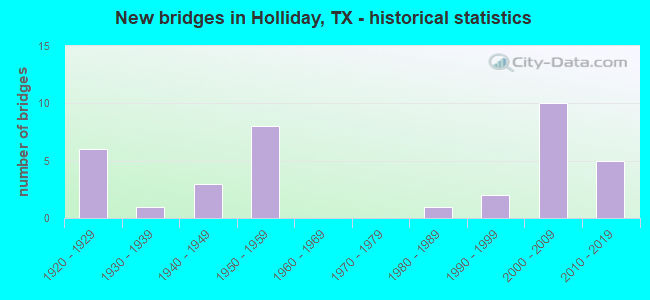
- New bridges - historical statistics
- 61920-1929
- 11930-1939
- 31940-1949
- 81950-1959
- 11980-1989
- 21990-1999
- 102000-2009
- 52010-2019

- Reconstructed bridges - Historical Statistics
- 11930-1939
- 01940-1949
- 11950-1959
- 01960-1969
- 51970-1979
- 01980-1989
- 11990-1999
- 32000-2009


- Bridge Condition - Deck
- 63.6%Good
- 18.2%Satisfactory
- 18.2%Fair

- Bridge Condition - Superstructure
- 27.3%Very good
- 36.4%Good
- 18.2%Satisfactory
- 18.2%Fair

- Bridge Condition - Substructure
- 27.3%Good
- 45.5%Satisfactory
- 27.3%Fair

- Bridge Condition - Channel
- 21.4%Very good
- 25.0%Good
- 39.3%Satisfactory
- 14.3%Fair

- Bridge Condition - Culverts
- 38.1%Good
- 28.6%Satisfactory
- 28.6%Fair
- 4.8%Serious
Find on map >> Show street view
Structure Number: 30050013307014, Location: 3.2 MI E OF FM 210 S (Lat: 33.423114, Lng: -98.877075), Route carried "on" structure: State highway 114, Year Built: 1929, Year Reconstructed: 1958, Status: Open, Structure Length: 1.31m (4.30ft), Average Daily Traffic: 1,432 (year 2020), Truck Traffic: 39%, Average Future Daily Traffic: 2,005 (year 2040), Features Intersected: KICKAPOO CREEK
Minimum Vertical Clearance: 30+ m (98+ ft), Kilometerpoint: 8.219, Lanes on structure: 2, Owner: State Highway Agency, Approaching Roadway Width: 12.2m (40.0ft), Material/Design: Concrete, Design/Construction: Culvert, Number Of Spans In Main Unit: 5, Length of Maximum Span: 2.4m (7.9ft), Curb-To-Curb Width: 14.6m (47.9ft), Out-to-Out Width: 15.9m (52.2ft)
Condition: Channel: Satisfactory, Culverts: Fair, Operating Rating: 32.7 metric tons, Method Used To Determine Operating Rating: Field evaluation and documented engineering judgment, Inventory Rating: 24.5 metric tons, Method Used To Determine Inventory Rating: Field evaluation and documented engineering judgment, Structural Evaluation: Somewhat better than minimum adequacy, Deck Geometry: Superior to present desirable criteria, Waterway Adequacy: Equal to present minimum criteria, Approach Roadway Alignment: Equal to present desirable criteria, Designated Inspection Frequency: Every 24 months, Inspection Date: December 2021, Deck Structure Type: Concrete Cast-file-Place, Wearing Surface/Protective System: Wearing Surface: Bituminous
Find on map >> Show street view
Structure Number: 30050015605012, Location: 1.0 MI E OF FM 368 (Lat: 33.823656, Lng: -98.680503), Route carried "on" structure: State highway 82, Year Built: 1928, Year Reconstructed: 1983, Status: Open, Structure Length: 0.85m (2.79ft), Average Daily Traffic: 2,460 (year 2013), Truck Traffic: 23%, Average Future Daily Traffic: 3,440 (year 2033), Features Intersected: DRAW
Minimum Vertical Clearance: 30+ m (98+ ft), Kilometerpoint: 28.471, Lanes on structure: 3, Owner: State Highway Agency, Approaching Roadway Width: 16.2m (53.1ft), Material/Design: Concrete, Design/Construction: Culvert, Number Of Spans In Main Unit: 5, Length of Maximum Span: 1.5m (4.9ft), Curb-To-Curb Width: 21.1m (69.2ft), Out-to-Out Width: 21.6m (70.9ft)
Condition: Channel: Fair, Culverts: Satisfactory, Operating Rating: 24.5 metric tons, Method Used To Determine Operating Rating: Field evaluation and documented engineering judgment, Inventory Rating: 18.1 metric tons, Method Used To Determine Inventory Rating: Field evaluation and documented engineering judgment, Structural Evaluation: Somewhat better than minimum adequacy, Deck Geometry: Superior to present desirable criteria, Waterway Adequacy: Equal to present minimum criteria, Approach Roadway Alignment: Equal to present desirable criteria, Designated Inspection Frequency: Every 24 months, Inspection Date: December 2021, Deck Structure Type: Concrete Cast-file-Place, Wearing Surface/Protective System: Wearing Surface: Bituminous
Find on map >> Show street view
Structure Number: 30050015605013, Location: 1.0 MI E OF FM 368 (Lat: 33.822914, Lng: -98.681278), Route carried "on" structure: State highway 82, Year Built: 1928, Year Reconstructed: 1983, Status: Open, Structure Length: 1.22m (4.00ft), Average Daily Traffic: 2,460 (year 2013), Truck Traffic: 23%, Average Future Daily Traffic: 3,440 (year 2033), Features Intersected: DRAW
Minimum Vertical Clearance: 30+ m (98+ ft), Kilometerpoint: 28.403, Lanes on structure: 3, Owner: State Highway Agency, Approaching Roadway Width: 16.5m (54.1ft), Material/Design: Concrete, Design/Construction: Culvert, Number Of Spans In Main Unit: 6, Length of Maximum Span: 1.8m (5.9ft), Curb-To-Curb Width: 21.1m (69.2ft), Out-to-Out Width: 21.6m (70.9ft)
Condition: Channel: Fair, Culverts: Serious, Operating Rating: 24.5 metric tons, Method Used To Determine Operating Rating: Field evaluation and documented engineering judgment, Inventory Rating: 16.3 metric tons, Method Used To Determine Inventory Rating: Field evaluation and documented engineering judgment, Structural Evaluation: High priority of corrective action, Deck Geometry: Superior to present desirable criteria, Waterway Adequacy: Equal to present minimum criteria, Approach Roadway Alignment: Equal to present desirable criteria, Designated Inspection Frequency: Every 24 months, Inspection Date: December 2021, Deck Structure Type: Concrete Cast-file-Place, Wearing Surface/Protective System: Wearing Surface: Bituminous
Find on map >> Show street view
Structure Number: 30050015605014, Location: 1.4 MI W OF FM 368 N (Lat: 33.807192, Lng: -98.720486), Route carried "on" structure: US 82, Year Built: 1928, Year Reconstructed: 2004, Status: Open, Structure Length: 1.22m (4.00ft), Average Daily Traffic: 4,468 (year 2020), Truck Traffic: 23%, Average Future Daily Traffic: 6,255 (year 2040), Features Intersected: DRAW
Minimum Vertical Clearance: 30+ m (98+ ft), Kilometerpoint: 24.317, Lanes on structure: 4, Owner: State Highway Agency, Approaching Roadway Width: 23.2m (76.1ft), Material/Design: Concrete, Design/Construction: Culvert, Number Of Spans In Main Unit: 6, Length of Maximum Span: 1.8m (5.9ft)
Condition: Channel: Very good, Culverts: Fair, Operating Rating: 32.7 metric tons, Method Used To Determine Operating Rating: Field evaluation and documented engineering judgment, Inventory Rating: 24.5 metric tons, Method Used To Determine Inventory Rating: Field evaluation and documented engineering judgment, Structural Evaluation: Somewhat better than minimum adequacy, Waterway Adequacy: Equal to present minimum criteria, Approach Roadway Alignment: Equal to present desirable criteria, Designated Inspection Frequency: Every 24 months, Inspection Date: December 2021
Find on map >> Show street view
Structure Number: 30050015617091, Location: INTER US 277 & FM 368 (Lat: 33.823128, Lng: -98.698972), Route carried "on" structure: US 277, Year Built: 2011, Status: Open, Structure Length: 6.86m (22.51ft), Average Daily Traffic: 3,876 (year 2020), Truck Traffic: 31%, Average Future Daily Traffic: 5,581 (year 2040), Design Load: HL 93, Features Intersected: FM 368
Minimum Vertical Clearance: 5.61m (18.41ft), Kilometerpoint: 27.272, Lanes on structure: 2, Lanes under structure: 2, Owner: State Highway Agency, Approaching Roadway Width: 11.6m (38.1ft), Skew: 12 degrees, Material/Design: Prestressed concrete, Design/Construction: Stringer/Multi-beam, Number Of Spans In Main Unit: 3, Length of Maximum Span: 22.9m (75.1ft), Curb-To-Curb Width: 11.6m (38.1ft), Out-to-Out Width: 12.4m (40.7ft)
Condition: Deck: Good, Superstructure: Very good, Substructure: Good, Operating Rating: 54.4 metric tons, Method Used To Determine Operating Rating: Assigned ratings based on Load and Resistance Factor Design (LRFD) reported in metric tons, Inventory Rating: 32.7 metric tons, Method Used To Determine Inventory Rating: Assigned ratings based on Load and Resistance Factor Design (LRFD) reported in metric tons, Structural Evaluation: Better than present minimum criteria, Deck Geometry: Better than present minimum criteria, Underclear: Superior to present desirable criteria, Approach Roadway Alignment: Equal to present desirable criteria, Designated Inspection Frequency: Every 24 months, Inspection Date: December 2021, Deck Structure Type: Concrete Precast Panels, Wearing Surface/Protective System: Membrane: Other, Deck Protection: Epoxy Coated Reinforcing
Find on map >> Show street view
Structure Number: 30050015617092, Location: INTER US277/82 & FM 368 (Lat: 33.823825, Lng: -98.698514), Route carried "on" structure: US 277, Year Built: 2011, Status: Open, Structure Length: 6.86m (22.51ft), Average Daily Traffic: 3,876 (year 2020), Truck Traffic: 19%, Average Future Daily Traffic: 5,581 (year 2040), Design Load: HL 93, Features Intersected: FM 368
Minimum Vertical Clearance: 30+ m (98+ ft), Kilometerpoint: 27.272, Lanes on structure: 2, Lanes under structure: 2, Owner: State Highway Agency, Approaching Roadway Width: 11.6m (38.1ft), Skew: 12 degrees, Material/Design: Prestressed concrete, Design/Construction: Stringer/Multi-beam, Number Of Spans In Main Unit: 3, Length of Maximum Span: 22.9m (75.1ft), Curb-To-Curb Width: 11.6m (38.1ft), Out-to-Out Width: 12.4m (40.7ft)
Condition: Deck: Good, Superstructure: Very good, Substructure: Good, Operating Rating: 54.4 metric tons, Method Used To Determine Operating Rating: Assigned ratings based on Load and Resistance Factor Design (LRFD) reported in metric tons, Inventory Rating: 32.7 metric tons, Method Used To Determine Inventory Rating: Assigned ratings based on Load and Resistance Factor Design (LRFD) reported in metric tons, Structural Evaluation: Better than present minimum criteria, Deck Geometry: Better than present minimum criteria, Underclear: Superior to present desirable criteria, Approach Roadway Alignment: Equal to present desirable criteria, Designated Inspection Frequency: Every 24 months, Inspection Date: December 2021, Deck Structure Type: Concrete Precast Panels, Wearing Surface/Protective System: Membrane: Other, Deck Protection: Epoxy Coated Reinforcing
Find on map >> Show street view
Structure Number: 30050015617119, Location: AT INTERSECTION OF FM 368 (Lat: 33.822900, Lng: -98.698589), Route carried "on" structure: ServiceUS 277, Year Built: 2006, Status: Open, Structure Length: 0.98m (3.22ft), Average Daily Traffic: 3,000 (year 2010), Truck Traffic: 19%, Average Future Daily Traffic: 4,500 (year 2027), Design Load: HS 20, Features Intersected: DRAW
Minimum Vertical Clearance: 30+ m (98+ ft), Kilometerpoint: 31.711, Lanes on structure: 2, Owner: State Highway Agency, Approaching Roadway Width: 11.6m (38.1ft), Skew: 4 degrees, Material/Design: Concrete, Design/Construction: Culvert, Number Of Spans In Main Unit: 4, Length of Maximum Span: 2.1m (6.9ft), Curb-To-Curb Width: 11.6m (38.1ft), Out-to-Out Width: 26.8m (87.9ft)
Condition: Channel: Good, Culverts: Good, Operating Rating: 54.4 metric tons, Method Used To Determine Operating Rating: Assigned rating based on Load Factor Design (LFD) reported in metric tons, Inventory Rating: 32.7 metric tons, Method Used To Determine Inventory Rating: Assigned rating based on Load Factor Design (LFD) reported in metric tons, Structural Evaluation: Better than present minimum criteria, Deck Geometry: Better than present minimum criteria, Waterway Adequacy: Equal to present minimum criteria, Approach Roadway Alignment: Equal to present desirable criteria, Designated Inspection Frequency: Every 24 months, Inspection Date: December 2021, Deck Structure Type: Concrete Cast-file-Place, Wearing Surface/Protective System: Wearing Surface: Bituminous
Find on map >> Show street view
Structure Number: 30050015617121, Location: 0.1 MI W OF FM 368 (Lat: 33.823406, Lng: -98.700156), Route carried "on" structure: US 277, Year Built: 2006, Year Reconstructed: 2011, Status: Open, Structure Length: 1.16m (3.81ft), Average Daily Traffic: 3,876 (year 2020), Truck Traffic: 19%, Average Future Daily Traffic: 5,581 (year 2040), Design Load: HS 20, Features Intersected: DRAW
Minimum Vertical Clearance: 30+ m (98+ ft), Kilometerpoint: 26.771, Lanes on structure: 6, Owner: State Highway Agency, Approaching Roadway Width: 34.7m (113.8ft), Skew: 4 degrees, Material/Design: Concrete, Design/Construction: Culvert, Number Of Spans In Main Unit: 4, Length of Maximum Span: 1.8m (5.9ft)
Condition: Channel: Good, Culverts: Good, Operating Rating: 54.4 metric tons, Method Used To Determine Operating Rating: Assigned rating based on Load Factor Design (LFD) reported in metric tons, Inventory Rating: 32.7 metric tons, Method Used To Determine Inventory Rating: Assigned rating based on Load Factor Design (LFD) reported in metric tons, Structural Evaluation: Better than present minimum criteria, Waterway Adequacy: Superior to present desirable criteria, Approach Roadway Alignment: Equal to present desirable criteria, Designated Inspection Frequency: Every 24 months, Inspection Date: December 2021
Find on map >> Show street view
Structure Number: 30050015617122, Location: 0.3 MI E OF FM 368 (Lat: 33.825489, Lng: -98.692275), Route carried "on" structure: ServiceUS 277, Year Built: 2006, Year Reconstructed: 2011, Status: Open, Structure Length: 1.16m (3.81ft), Average Daily Traffic: 3,876 (year 2020), Truck Traffic: 31%, Average Future Daily Traffic: 5,581 (year 2040), Design Load: HS 20, Features Intersected: DRAW
Minimum Vertical Clearance: 30+ m (98+ ft), Kilometerpoint: 27.460, Lanes on structure: 3, Owner: State Highway Agency, Approaching Roadway Width: 34.7m (113.8ft), Skew: 4 degrees, Material/Design: Concrete, Design/Construction: Culvert, Number Of Spans In Main Unit: 4, Length of Maximum Span: 1.8m (5.9ft)
Condition: Channel: Satisfactory, Culverts: Satisfactory, Operating Rating: 54.4 metric tons, Method Used To Determine Operating Rating: Assigned rating based on Load Factor Design (LFD) reported in metric tons, Inventory Rating: 32.7 metric tons, Method Used To Determine Inventory Rating: Assigned rating based on Load Factor Design (LFD) reported in metric tons, Structural Evaluation: Equal to present minimum criteria, Waterway Adequacy: Equal to present minimum criteria, Approach Roadway Alignment: Equal to present desirable criteria, Designated Inspection Frequency: Every 24 months, Inspection Date: December 2021
Find on map >> Show street view
Structure Number: 30050015617124, Location: 0.4 MI E OF FM 368 (Lat: 33.825947, Lng: -98.693586), Route carried "on" structure: US 277, Year Built: 2006, Year Reconstructed: 2011, Status: Open, Structure Length: 1.16m (3.81ft), Average Daily Traffic: 3,876 (year 2020), Truck Traffic: 31%, Average Future Daily Traffic: 5,581 (year 2040), Design Load: HS 20, Features Intersected: DRAW
Minimum Vertical Clearance: 30+ m (98+ ft), Kilometerpoint: 27.536, Lanes on structure: 4, Owner: State Highway Agency, Approaching Roadway Width: 34.7m (113.8ft), Skew: 4 degrees, Material/Design: Concrete, Design/Construction: Culvert, Number Of Spans In Main Unit: 4, Length of Maximum Span: 1.8m (5.9ft)
Condition: Channel: Good, Culverts: Good, Operating Rating: 54.4 metric tons, Method Used To Determine Operating Rating: Assigned rating based on Load Factor Design (LFD) reported in metric tons, Inventory Rating: 32.7 metric tons, Method Used To Determine Inventory Rating: Assigned rating based on Load Factor Design (LFD) reported in metric tons, Structural Evaluation: Better than present minimum criteria, Waterway Adequacy: Equal to present minimum criteria, Approach Roadway Alignment: Equal to present desirable criteria, Designated Inspection Frequency: Every 24 months, Inspection Date: December 2021
Find on map >> Show street view
Structure Number: 30050015617201, Location: 1.6 MI E OF FM 368 (Lat: 33.833467, Lng: -98.672606), Route carried "on" structure: US 277, Year Built: 2006, Status: Open, Structure Length: 6.86m (22.51ft), Average Daily Traffic: 3,511 (year 2020), Truck Traffic: 24%, Average Future Daily Traffic: 9,115 (year 2040), Design Load: HS 20, Features Intersected: BU 277
Minimum Vertical Clearance: 30+ m (98+ ft), Kilometerpoint: 29.868, Lanes on structure: 2, Lanes under structure: 2, Owner: State Highway Agency, Approaching Roadway Width: 11.5m (37.7ft), Skew: 2 degrees, Material/Design: Prestressed concrete continuous, Design/Construction: Stringer/Multi-beam, Number Of Spans In Main Unit: 3, Length of Maximum Span: 22.9m (75.1ft), Curb-To-Curb Width: 11.6m (38.1ft), Out-to-Out Width: 12.4m (40.7ft)
Condition: Deck: Good, Superstructure: Good, Substructure: Satisfactory, Operating Rating: 54.4 metric tons, Method Used To Determine Operating Rating: Assigned rating based on Load Factor Design (LFD) reported in metric tons, Inventory Rating: 32.7 metric tons, Method Used To Determine Inventory Rating: Assigned rating based on Load Factor Design (LFD) reported in metric tons, Structural Evaluation: Equal to present minimum criteria, Deck Geometry: Better than present minimum criteria, Underclear: Equal to present minimum criteria, Approach Roadway Alignment: Equal to present desirable criteria, Designated Inspection Frequency: Every 24 months, Inspection Date: December 2021, Deck Structure Type: Concrete Cast-file-Place, Wearing Surface/Protective System: Deck Protection: Epoxy Coated Reinforcing
Find on map >> Show street view
Structure Number: 30050015617202, Location: 1.6 MI E OF FM 368 (Lat: 33.834036, Lng: -98.671894), Route carried "on" structure: US 277, Year Built: 2006, Status: Open, Structure Length: 6.86m (22.51ft), Average Daily Traffic: 6,511 (year 2020), Truck Traffic: 24%, Average Future Daily Traffic: 9,115 (year 2040), Design Load: HS 20, Features Intersected: BU 277
Minimum Vertical Clearance: 30+ m (98+ ft), Kilometerpoint: 29.868, Lanes on structure: 2, Lanes under structure: 2, Owner: State Highway Agency, Approaching Roadway Width: 11.5m (37.7ft), Skew: 2 degrees, Material/Design: Prestressed concrete continuous, Design/Construction: Stringer/Multi-beam, Number Of Spans In Main Unit: 3, Length of Maximum Span: 22.9m (75.1ft), Curb-To-Curb Width: 11.5m (37.7ft), Out-to-Out Width: 12.2m (40.0ft)
Condition: Deck: Good, Superstructure: Good, Substructure: Satisfactory, Operating Rating: 54.4 metric tons, Method Used To Determine Operating Rating: Assigned rating based on Load Factor Design (LFD) reported in metric tons, Inventory Rating: 32.7 metric tons, Method Used To Determine Inventory Rating: Assigned rating based on Load Factor Design (LFD) reported in metric tons, Structural Evaluation: Equal to present minimum criteria, Deck Geometry: Equal to present minimum criteria, Underclear: Better than present minimum criteria, Approach Roadway Alignment: Equal to present desirable criteria, Designated Inspection Frequency: Every 24 months, Inspection Date: December 2021, Deck Structure Type: Concrete Cast-file-Place, Wearing Surface/Protective System: Deck Protection: Epoxy Coated Reinforcing
Find on map >> Show street view
Structure Number: 30050080403003, Location: 1.9 MI S OF US 277 (Lat: 33.790778, Lng: -98.687128), Route carried "on" structure: State highway 368, Year Built: 1951, Status: Open, Structure Length: 0.67m (2.20ft), Average Daily Traffic: 426 (year 2020), Truck Traffic: 6%, Average Future Daily Traffic: 596 (year 2040), Features Intersected: DRAW
Minimum Vertical Clearance: 30+ m (98+ ft), Kilometerpoint: 11.249, Lanes on structure: 2, Owner: State Highway Agency, Approaching Roadway Width: 6.2m (20.3ft), Material/Design: Concrete, Design/Construction: Culvert, Number Of Spans In Main Unit: 3, Length of Maximum Span: 2.1m (6.9ft), Curb-To-Curb Width: 7.9m (25.9ft), Out-to-Out Width: 8.3m (27.2ft)
Condition: Channel: Good, Culverts: Fair, Operating Rating: 39.9 metric tons, Method Used To Determine Operating Rating: Load Factor (LF), Inventory Rating: 23.6 metric tons, Method Used To Determine Inventory Rating: Load Factor (LF), Structural Evaluation: Somewhat better than minimum adequacy, Deck Geometry: Somewhat better than minimum adequacy, Waterway Adequacy: Equal to present minimum criteria, Approach Roadway Alignment: Equal to present desirable criteria, Designated Inspection Frequency: Every 24 months, Inspection Date: December 2021, Deck Structure Type: Concrete Cast-file-Place, Wearing Surface/Protective System: Wearing Surface: Bituminous
Find on map >> Show street view
Structure Number: 30050080403004, Location: 2.25 MI S OF US 277 (Lat: 33.787933, Lng: -98.687214), Route carried "on" structure: State highway 368, Year Built: 1951, Status: Open, Structure Length: 0.79m (2.59ft), Average Daily Traffic: 426 (year 2020), Truck Traffic: 6%, Average Future Daily Traffic: 596 (year 2040), Features Intersected: DRAW
Minimum Vertical Clearance: 30+ m (98+ ft), Kilometerpoint: 11.565, Lanes on structure: 2, Owner: State Highway Agency, Approaching Roadway Width: 6.4m (21.0ft), Material/Design: Concrete, Design/Construction: Culvert, Number Of Spans In Main Unit: 4, Length of Maximum Span: 1.8m (5.9ft), Curb-To-Curb Width: 8.0m (26.2ft), Out-to-Out Width: 8.4m (27.6ft)
Condition: Channel: Satisfactory, Culverts: Good, Operating Rating: 39.9 metric tons, Method Used To Determine Operating Rating: Load Factor (LF), Inventory Rating: 23.6 metric tons, Method Used To Determine Inventory Rating: Load Factor (LF), Structural Evaluation: Equal to present minimum criteria, Deck Geometry: Somewhat better than minimum adequacy, Waterway Adequacy: Equal to present minimum criteria, Approach Roadway Alignment: Equal to present desirable criteria, Designated Inspection Frequency: Every 24 months, Inspection Date: December 2021, Deck Structure Type: Concrete Cast-file-Place, Wearing Surface/Protective System: Wearing Surface: Bituminous
Find on map >> Show street view
Structure Number: 30050080403005, Location: 2.75 MI S OF US 277 (Lat: 33.778067, Lng: -98.687311), Route carried "on" structure: State highway 368, Year Built: 1951, Status: Open, Structure Length: 1.37m (4.49ft), Average Daily Traffic: 426 (year 2020), Truck Traffic: 6%, Average Future Daily Traffic: 576 (year 2040), Features Intersected: HOLLIDAY CREEK
Minimum Vertical Clearance: 30+ m (98+ ft), Kilometerpoint: 12.649, Lanes on structure: 2, Owner: State Highway Agency, Approaching Roadway Width: 6.1m (20.0ft), Material/Design: Concrete, Design/Construction: Culvert, Number Of Spans In Main Unit: 5, Length of Maximum Span: 2.7m (8.9ft), Curb-To-Curb Width: 7.9m (25.9ft), Out-to-Out Width: 8.4m (27.6ft)
Condition: Channel: Satisfactory, Culverts: Satisfactory, Operating Rating: 32.7 metric tons, Method Used To Determine Operating Rating: Field evaluation and documented engineering judgment, Inventory Rating: 24.5 metric tons, Method Used To Determine Inventory Rating: Field evaluation and documented engineering judgment, Structural Evaluation: Equal to present minimum criteria, Deck Geometry: Somewhat better than minimum adequacy, Waterway Adequacy: Equal to present minimum criteria, Approach Roadway Alignment: Equal to present desirable criteria, Designated Inspection Frequency: Every 24 months, Inspection Date: December 2021, Deck Structure Type: Concrete Cast-file-Place, Wearing Surface/Protective System: Wearing Surface: Bituminous
Find on map >> Show street view
Structure Number: 30050080403006, Location: 3.0 MI S OF US 277 (Lat: 33.774250, Lng: -98.687356), Route carried "on" structure: State highway 368, Year Built: 1951, Status: Open, Structure Length: 0.67m (2.20ft), Average Daily Traffic: 426 (year 2020), Truck Traffic: 6%, Average Future Daily Traffic: 596 (year 2040), Features Intersected: DRAW
Minimum Vertical Clearance: 30+ m (98+ ft), Kilometerpoint: 13.076, Lanes on structure: 2, Owner: State Highway Agency, Approaching Roadway Width: 6.2m (20.3ft), Material/Design: Concrete, Design/Construction: Culvert, Number Of Spans In Main Unit: 3, Length of Maximum Span: 2.1m (6.9ft), Curb-To-Curb Width: 7.9m (25.9ft), Out-to-Out Width: 8.4m (27.6ft)
Condition: Channel: Very good, Culverts: Fair, Operating Rating: 39.9 metric tons, Method Used To Determine Operating Rating: Load Factor (LF), Inventory Rating: 23.6 metric tons, Method Used To Determine Inventory Rating: Load Factor (LF), Structural Evaluation: Somewhat better than minimum adequacy, Deck Geometry: Somewhat better than minimum adequacy, Waterway Adequacy: Equal to present minimum criteria, Approach Roadway Alignment: Equal to present desirable criteria, Designated Inspection Frequency: Every 24 months, Inspection Date: December 2021, Deck Structure Type: Concrete Cast-file-Place, Wearing Surface/Protective System: Wearing Surface: Bituminous
Find on map >> Show street view
Structure Number: 30050080403007, Location: 4.25 MI S OF US 277 (Lat: 33.757200, Lng: -98.687775), Route carried "on" structure: State highway 368, Year Built: 1951, Status: Open, Structure Length: 1.13m (3.71ft), Average Daily Traffic: 426 (year 2020), Truck Traffic: 6%, Average Future Daily Traffic: 596 (year 2040), Features Intersected: PANTHER CREEK
Minimum Vertical Clearance: 30+ m (98+ ft), Kilometerpoint: 15.009, Lanes on structure: 2, Owner: State Highway Agency, Approaching Roadway Width: 6.1m (20.0ft), Material/Design: Concrete, Design/Construction: Culvert, Number Of Spans In Main Unit: 5, Length of Maximum Span: 2.1m (6.9ft), Curb-To-Curb Width: 7.8m (25.6ft), Out-to-Out Width: 8.2m (26.9ft)
Condition: Channel: Good, Culverts: Satisfactory, Operating Rating: 39.9 metric tons, Method Used To Determine Operating Rating: Load Factor (LF), Inventory Rating: 23.6 metric tons, Method Used To Determine Inventory Rating: Load Factor (LF), Structural Evaluation: Equal to present minimum criteria, Deck Geometry: Meets minimum limits, Waterway Adequacy: Equal to present minimum criteria, Approach Roadway Alignment: Somewhat better than minimum adequacy, Designated Inspection Frequency: Every 24 months, Inspection Date: December 2021, Deck Structure Type: Concrete Cast-file-Place, Wearing Surface/Protective System: Wearing Surface: Bituminous
Find on map >> Show street view
Structure Number: 30050183701001, Location: 1.5 MI E OF FM 368 (Lat: 33.795033, Lng: -98.659025), Route carried "on" structure: State highway 1954, Year Built: 1954, Status: Closed, Structure Length: 2.74m (8.99ft), Average Daily Traffic: 532 (year 2020), Truck Traffic: 22%, Average Future Daily Traffic: 970 (year 2033), Design Load: H 15, Features Intersected: HOLLIDAY CREEK
Minimum Vertical Clearance: 30+ m (98+ ft), Kilometerpoint: 10.715, Lanes on structure: 2, Owner: State Highway Agency, Approaching Roadway Width: 6.1m (20.0ft), Material/Design: Concrete, Design/Construction: Stringer/Multi-beam, Number Of Spans In Main Unit: 3, Length of Maximum Span: 9.1m (29.9ft), Curb-To-Curb Width: 6.9m (22.6ft), Out-to-Out Width: 7.4m (24.3ft)
Condition: Deck: Satisfactory, Superstructure: Satisfactory, Substructure: Satisfactory, Channel: Satisfactory, Operating Rating: 49.9 metric tons, Method Used To Determine Operating Rating: Load Factor (LF), Inventory Rating: 29.0 metric tons, Method Used To Determine Inventory Rating: Load Factor (LF), Structural Evaluation: Equal to present minimum criteria, Deck Geometry: Meets minimum limits, Waterway Adequacy: Equal to present minimum criteria, Approach Roadway Alignment: Equal to present desirable criteria, Length Of Structure Improvement: 2.74m (8.99ft), Designated Inspection Frequency: Every 24 months, Inspection Date: December 2021, Bridge Improvement Cost: $388,000, Roadway Improvement Cost: $219,000, Total Project Cost: $670,000, Deck Structure Type: Concrete Cast-file-Place, Wearing Surface/Protective System: Wearing Surface: Bituminous
Find on map >> Show street view
Structure Number: 30050183701002, Location: 1.8 MI E OF FM 368 (Lat: 33.795025, Lng: -98.656889), Route carried "on" structure: State highway 1954, Year Built: 1954, Status: Closed, Structure Length: 1.83m (6.00ft), Average Daily Traffic: 532 (year 2020), Truck Traffic: 22%, Average Future Daily Traffic: 970 (year 2033), Design Load: H 15, Features Intersected: PANTHER CREEK
Minimum Vertical Clearance: 30+ m (98+ ft), Kilometerpoint: 10.921, Lanes on structure: 2, Owner: State Highway Agency, Approaching Roadway Width: 6.1m (20.0ft), Material/Design: Concrete, Design/Construction: Stringer/Multi-beam, Number Of Spans In Main Unit: 2, Length of Maximum Span: 9.1m (29.9ft), Curb-To-Curb Width: 6.9m (22.6ft), Out-to-Out Width: 7.4m (24.3ft)
Condition: Deck: Satisfactory, Superstructure: Satisfactory, Substructure: Fair, Channel: Satisfactory, Operating Rating: 49.9 metric tons, Method Used To Determine Operating Rating: Load Factor (LF), Inventory Rating: 29.0 metric tons, Method Used To Determine Inventory Rating: Load Factor (LF), Structural Evaluation: Somewhat better than minimum adequacy, Deck Geometry: Meets minimum limits, Waterway Adequacy: Equal to present minimum criteria, Approach Roadway Alignment: Equal to present desirable criteria, Length Of Structure Improvement: 1.83m (6.00ft), Designated Inspection Frequency: Every 24 months, Inspection Date: December 2021, Bridge Improvement Cost: $259,000, Roadway Improvement Cost: $146,000, Total Project Cost: $447,000, Deck Structure Type: Concrete Cast-file-Place, Wearing Surface/Protective System: Wearing Surface: Bituminous
Find on map >> Show street view
Structure Number: 30050359901001, Location: 1.3 MI W OF FM 1954 (Lat: 33.815606, Lng: -98.652825), Route carried "on" structure: State highway 440, Year Built: 1999, Status: Open, Structure Length: 2.26m (7.41ft), Average Daily Traffic: 1,028 (year 2020), Truck Traffic: 10%, Average Future Daily Traffic: 1,624 (year 2040), Design Load: HS 20, Features Intersected: HOLLIDAY CREEK
Minimum Vertical Clearance: 30+ m (98+ ft), Kilometerpoint: 0.570, Lanes on structure: 2, Owner: State Highway Agency, Approaching Roadway Width: 7.7m (25.3ft), Skew: 3 degrees, Material/Design: Concrete, Design/Construction: Culvert, Number Of Spans In Main Unit: 7, Length of Maximum Span: 2.7m (8.9ft), Curb-To-Curb Width: 18.3m (60.0ft), Out-to-Out Width: 19.1m (62.7ft)
Condition: Channel: Satisfactory, Culverts: Good, Operating Rating: 40.5 metric tons, Method Used To Determine Operating Rating: Load Factor (LF), Inventory Rating: 24.1 metric tons, Method Used To Determine Inventory Rating: Load Factor (LF), Structural Evaluation: Equal to present minimum criteria, Deck Geometry: Superior to present desirable criteria, Waterway Adequacy: Equal to present minimum criteria, Approach Roadway Alignment: Equal to present desirable criteria, Designated Inspection Frequency: Every 24 months, Inspection Date: December 2021, Deck Structure Type: Concrete Cast-file-Place, Wearing Surface/Protective System: Wearing Surface: Bituminous
Find on map >> Show street view
Structure Number: 30050359901002, Location: 1.1 MI W OF FM 1954 (Lat: 33.815642, Lng: -98.649514), Route carried "on" structure: State highway 440, Year Built: 1999, Status: Open, Structure Length: 0.82m (2.69ft), Average Daily Traffic: 1,028 (year 2020), Truck Traffic: 10%, Average Future Daily Traffic: 1,624 (year 2040), Design Load: HS 20, Features Intersected: HOLLIDAY CREEK RELIEF
Minimum Vertical Clearance: 30+ m (98+ ft), Kilometerpoint: 0.853, Lanes on structure: 2, Owner: State Highway Agency, Approaching Roadway Width: 7.6m (24.9ft), Skew: 1 degrees, Material/Design: Concrete, Design/Construction: Culvert, Number Of Spans In Main Unit: 4, Length of Maximum Span: 1.8m (5.9ft), Curb-To-Curb Width: 17.1m (56.1ft), Out-to-Out Width: 17.7m (58.1ft)
Condition: Channel: Very good, Culverts: Good, Operating Rating: 40.5 metric tons, Method Used To Determine Operating Rating: Load Factor (LF), Inventory Rating: 24.1 metric tons, Method Used To Determine Inventory Rating: Load Factor (LF), Structural Evaluation: Equal to present minimum criteria, Deck Geometry: Superior to present desirable criteria, Waterway Adequacy: Equal to present minimum criteria, Approach Roadway Alignment: Equal to present desirable criteria, Designated Inspection Frequency: Every 24 months, Inspection Date: December 2021, Deck Structure Type: Concrete Cast-file-Place, Wearing Surface/Protective System: Wearing Surface: Bituminous
Find on map >> Show street view
Structure Number: 30050AA0107001, Location: 0.65 MI N OF FM 440 (Lat: 33.823111, Lng: -98.637756), Route carried "on" structure: County highway 107, Year Built: 2008, Status: Open, Structure Length: 1.52m (4.99ft), Average Daily Traffic: 270 (year 2010), Average Future Daily Traffic: 325 (year 2032), Design Load: HL 93, Features Intersected: HOLLIDAY CREEK
Minimum Vertical Clearance: 30+ m (98+ ft), Kilometerpoint: 1.127, Lanes on structure: 2, Owner: County Highway Agency, Approaching Roadway Width: 5.5m (18.0ft), Skew: 3 degrees, Material/Design: Prestressed concrete, Design/Construction: Stringer/Multi-beam, Number Of Spans In Main Unit: 1, Length of Maximum Span: 15.2m (49.9ft), Curb-To-Curb Width: 7.2m (23.6ft), Out-to-Out Width: 7.9m (25.9ft)
Condition: Deck: Good, Superstructure: Very good, Substructure: Good, Channel: Very good, Operating Rating: 54.4 metric tons, Method Used To Determine Operating Rating: Assigned ratings based on Load and Resistance Factor Design (LRFD) reported in metric tons, Inventory Rating: 32.7 metric tons, Method Used To Determine Inventory Rating: Assigned ratings based on Load and Resistance Factor Design (LRFD) reported in metric tons, Structural Evaluation: Better than present minimum criteria, Deck Geometry: Meets minimum limits, Waterway Adequacy: Equal to present desirable criteria, Approach Roadway Alignment: Equal to present desirable criteria, Designated Inspection Frequency: Every 24 months, Inspection Date: October 2020, Deck Structure Type: Corrugated Steel, Wearing Surface/Protective System: Wearing Surface: Monolithic Concrete
Find on map >> Show street view
Structure Number: 30050AA0107002, Location: 0.75 MI N OF FM 440 (Lat: 33.824533, Lng: -98.637731), Route carried "on" structure: County highway 107, Year Built: 1989, Status: Open, Structure Length: 1.74m (5.71ft), Average Daily Traffic: 270 (year 2010), Average Future Daily Traffic: 325 (year 2032), Design Load: HS 20, Features Intersected: HOLLIDAY CREEK RELIEF
Minimum Vertical Clearance: 30+ m (98+ ft), Kilometerpoint: 0.966, Lanes on structure: 2, Owner: County Highway Agency, Approaching Roadway Width: 5.8m (19.0ft), Material/Design: Concrete, Design/Construction: Culvert, Number Of Spans In Main Unit: 6, Length of Maximum Span: 2.7m (8.9ft), Curb-To-Curb Width: 8.4m (27.6ft), Out-to-Out Width: 9.1m (29.9ft)
Condition: Channel: Very good, Culverts: Satisfactory, Operating Rating: 39.9 metric tons, Method Used To Determine Operating Rating: Load Factor (LF), Inventory Rating: 23.6 metric tons, Method Used To Determine Inventory Rating: Load Factor (LF), Structural Evaluation: Equal to present minimum criteria, Deck Geometry: Somewhat better than minimum adequacy, Waterway Adequacy: Meets minimum limits, Approach Roadway Alignment: Equal to present desirable criteria, Length Of Structure Improvement: 1.62m (5.31ft), Designated Inspection Frequency: Every 24 months, Inspection Date: October 2020, Total Project Cost: $45,000, Deck Structure Type: Concrete Cast-file-Place, Wearing Surface/Protective System: Wearing Surface: Bituminous
Find on map >> Show street view
Structure Number: 30050AA0246001, Location: 3.60 MI S OF US 82 (Lat: 33.756206, Lng: -98.718556), Route carried "on" structure: County highway 246, Year Built: 1949, Status: Posted for load, Structure Length: 0.79m (2.59ft), Average Daily Traffic: 50 (year 2010), Average Future Daily Traffic: 80 (year 2032), Features Intersected: HOLLIDAY CREEK
Minimum Vertical Clearance: 30+ m (98+ ft), Kilometerpoint: 1.770, Lanes on structure: 2, Owner: County Highway Agency, Approaching Roadway Width: 5.5m (18.0ft), Material/Design: Concrete, Design/Construction: Tee Beam, Number Of Spans In Main Unit: 1, Length of Maximum Span: 7.9m (25.9ft), Curb-To-Curb Width: 5.6m (18.4ft), Out-to-Out Width: 6.2m (20.3ft)
Condition: Deck: Fair, Superstructure: Fair, Substructure: Fair, Channel: Fair, Operating Rating: 18.1 metric tons, Method Used To Determine Operating Rating: Field evaluation and documented engineering judgment, Inventory Rating: 14.5 metric tons, Method Used To Determine Inventory Rating: Field evaluation and documented engineering judgment, Structural Evaluation: Meets minimum limits, Deck Geometry: Meets minimum limits, Waterway Adequacy: Better than present minimum criteria, Approach Roadway Alignment: Equal to present desirable criteria, Bridge Posting: Required (Relationship of Operating Rating to Maximum Legal Load: > 39.9% below), Length Of Structure Improvement: 1.37m (4.49ft), Designated Inspection Frequency: Every 24 months, Inspection Date: October 2020, Bridge Improvement Cost: $72,000, Roadway Improvement Cost: $10,000, Total Project Cost: $245,000, Deck Structure Type: Concrete Cast-file-Place
Find on map >> Show street view
Structure Number: 30050AA0246003, Location: 0.35 MI S OF US 82 (Lat: 33.803128, Lng: -98.716633), Route carried "on" structure: County highway 246, Year Built: 2018, Status: Open, Structure Length: 1.10m (3.61ft), Average Daily Traffic: 50 (year 2016), Average Future Daily Traffic: 80 (year 2036), Design Load: HL 93, Features Intersected: DRAW
Minimum Vertical Clearance: 30+ m (98+ ft), Kilometerpoint: 7.001, Lanes on structure: 2, Owner: County Highway Agency, Approaching Roadway Width: 5.5m (18.0ft), Material/Design: Concrete, Design/Construction: Culvert, Number Of Spans In Main Unit: 4, Length of Maximum Span: 2.4m (7.9ft), Curb-To-Curb Width: 7.3m (24.0ft), Out-to-Out Width: 7.9m (25.9ft)
Condition: Channel: Very good, Culverts: Good, Operating Rating: 54.4 metric tons, Method Used To Determine Operating Rating: Assigned ratings based on Load and Resistance Factor Design (LRFD) reported in metric tons, Inventory Rating: 32.7 metric tons, Method Used To Determine Inventory Rating: Assigned ratings based on Load and Resistance Factor Design (LRFD) reported in metric tons, Structural Evaluation: Better than present minimum criteria, Deck Geometry: Equal to present minimum criteria, Waterway Adequacy: Better than present minimum criteria, Approach Roadway Alignment: Equal to present desirable criteria, Designated Inspection Frequency: Every 24 months, Inspection Date: October 2020, Deck Structure Type: Concrete Cast-file-Place, Wearing Surface/Protective System: Wearing Surface: Gravel
Find on map >> Show street view
Structure Number: 32430015604011, Location: 1.00 MI SW OF SH 258 (Lat: 33.844844, Lng: -98.658386), Route carried "on" structure: US 82, Year Built: 1929, Year Reconstructed: 1983, Status: Open, Structure Length: 1.13m (3.71ft), Average Daily Traffic: 6,511 (year 2020), Truck Traffic: 5%, Average Future Daily Traffic: 9,510 (year 2033), Design Load: HS 20, Features Intersected: CALL FIELD CANAL
Minimum Vertical Clearance: 30+ m (98+ ft), Kilometerpoint: 33.634, Lanes on structure: 4, Owner: State Highway Agency, Approaching Roadway Width: 19.8m (65.0ft), Material/Design: Prestressed concrete, Design/Construction: Box Beam or Girders - Multiple, Number Of Spans In Main Unit: 1, Length of Maximum Span: 11.0m (36.1ft), Curb-To-Curb Width: 20.4m (66.9ft), Out-to-Out Width: 21.4m (70.2ft)
Condition: Deck: Good, Superstructure: Good, Substructure: Satisfactory, Channel: Good, Operating Rating: 54.4 metric tons, Method Used To Determine Operating Rating: Assigned rating based on Load Factor Design (LFD) reported in metric tons, Inventory Rating: 32.7 metric tons, Method Used To Determine Inventory Rating: Assigned rating based on Load Factor Design (LFD) reported in metric tons, Structural Evaluation: Equal to present minimum criteria, Deck Geometry: Superior to present desirable criteria, Waterway Adequacy: Equal to present minimum criteria, Approach Roadway Alignment: Equal to present desirable criteria, Designated Inspection Frequency: Every 24 months, Inspection Date: May 2020, Deck Structure Type: Concrete Cast-file-Place, Wearing Surface/Protective System: Wearing Surface: Bituminous
Find on map >> Show street view
Structure Number: 32430054401001, Location: 0.4 MI E OF FM 368 (Lat: 33.855831, Lng: -98.704219), Route carried "on" structure: State highway 258, Year Built: 1925, Year Reconstructed: 1939, Status: Open, Structure Length: 1.04m (3.41ft), Average Daily Traffic: 1,751 (year 2020), Truck Traffic: 29%, Average Future Daily Traffic: 2,740 (year 2033), Features Intersected: DRAW
Minimum Vertical Clearance: 30+ m (98+ ft), Kilometerpoint: 14.557, Lanes on structure: 2, Owner: State Highway Agency, Approaching Roadway Width: 8.5m (27.9ft), Material/Design: Concrete, Design/Construction: Culvert, Number Of Spans In Main Unit: 5, Length of Maximum Span: 1.8m (5.9ft), Curb-To-Curb Width: 8.8m (28.9ft), Out-to-Out Width: 11.1m (36.4ft)
Condition: Channel: Satisfactory, Culverts: Fair, Operating Rating: 32.7 metric tons, Method Used To Determine Operating Rating: Field evaluation and documented engineering judgment, Inventory Rating: 24.5 metric tons, Method Used To Determine Inventory Rating: Field evaluation and documented engineering judgment, Structural Evaluation: Somewhat better than minimum adequacy, Deck Geometry: Somewhat better than minimum adequacy, Waterway Adequacy: Equal to present minimum criteria, Approach Roadway Alignment: Equal to present desirable criteria, Designated Inspection Frequency: Every 24 months, Inspection Date: June 2020, Deck Structure Type: Concrete Cast-file-Place, Wearing Surface/Protective System: Wearing Surface: Bituminous
Find on map >> Show street view
Structure Number: 32430054401002, Location: 1.5 MI W OF FM 368 (Lat: 33.856103, Lng: -98.732461), Route carried "on" structure: State highway 258, Year Built: 1939, Status: Open, Structure Length: 1.04m (3.41ft), Average Daily Traffic: 1,258 (year 2020), Truck Traffic: 29%, Average Future Daily Traffic: 2,250 (year 2033), Design Load: H 15, Features Intersected: ANTELOPE CREEK
Minimum Vertical Clearance: 30+ m (98+ ft), Kilometerpoint: 11.576, Lanes on structure: 2, Owner: State Highway Agency, Approaching Roadway Width: 8.5m (27.9ft), Material/Design: Concrete, Design/Construction: Culvert, Number Of Spans In Main Unit: 5, Length of Maximum Span: 1.8m (5.9ft), Curb-To-Curb Width: 8.6m (28.2ft), Out-to-Out Width: 11.0m (36.1ft)
Condition: Channel: Fair, Culverts: Satisfactory, Operating Rating: 39.9 metric tons, Method Used To Determine Operating Rating: Load Factor (LF), Inventory Rating: 23.6 metric tons, Method Used To Determine Inventory Rating: Load Factor (LF), Structural Evaluation: Equal to present minimum criteria, Deck Geometry: Somewhat better than minimum adequacy, Waterway Adequacy: Equal to present minimum criteria, Approach Roadway Alignment: Equal to present desirable criteria, Designated Inspection Frequency: Every 24 months, Inspection Date: June 2020, Deck Structure Type: Concrete Cast-file-Place, Wearing Surface/Protective System: Wearing Surface: Bituminous
Find on map >> Show street view
Structure Number: 32430080401001, Location: 1.9 MI N OF SH 258 (Lat: 33.883894, Lng: -98.705614), Route carried "on" structure: State highway 368, Year Built: 1940, Year Reconstructed: 1970, Status: Open, Structure Length: 0.67m (2.20ft), Average Daily Traffic: 716 (year 2020), Truck Traffic: 9%, Average Future Daily Traffic: 1,150 (year 2033), Features Intersected: ANTELOPE CREEK
Minimum Vertical Clearance: 30+ m (98+ ft), Kilometerpoint: 6.531, Lanes on structure: 2, Owner: State Highway Agency, Approaching Roadway Width: 7.3m (24.0ft), Material/Design: Concrete, Design/Construction: Culvert, Number Of Spans In Main Unit: 2, Length of Maximum Span: 3.0m (9.8ft), Curb-To-Curb Width: 11.9m (39.0ft), Out-to-Out Width: 12.6m (41.3ft)
Condition: Channel: Satisfactory, Culverts: Fair, Operating Rating: 32.7 metric tons, Method Used To Determine Operating Rating: Field evaluation and documented engineering judgment, Inventory Rating: 24.5 metric tons, Method Used To Determine Inventory Rating: Field evaluation and documented engineering judgment, Structural Evaluation: Somewhat better than minimum adequacy, Deck Geometry: Better than present minimum criteria, Waterway Adequacy: Equal to present minimum criteria, Approach Roadway Alignment: Equal to present desirable criteria, Designated Inspection Frequency: Every 24 months, Inspection Date: June 2020, Deck Structure Type: Concrete Cast-file-Place, Wearing Surface/Protective System: Wearing Surface: Bituminous
Find on map >> Show street view
Structure Number: 32430080401002, Location: 0.5 MI S OF SH 258 (Lat: 33.848767, Lng: -98.707342), Route carried "on" structure: State highway 368, Year Built: 1947, Year Reconstructed: 1970, Status: Open, Structure Length: 0.70m (2.30ft), Average Daily Traffic: 816 (year 2020), Truck Traffic: 9%, Average Future Daily Traffic: 1,160 (year 2033), Design Load: H 15, Features Intersected: CALL FIELD CANAL
Minimum Vertical Clearance: 30+ m (98+ ft), Kilometerpoint: 10.448, Lanes on structure: 2, Owner: State Highway Agency, Approaching Roadway Width: 7.3m (24.0ft), Skew: 2 degrees, Material/Design: Concrete, Design/Construction: Slab, Number Of Spans In Main Unit: 1, Length of Maximum Span: 6.7m (22.0ft), Curb-To-Curb Width: 11.0m (36.1ft), Out-to-Out Width: 11.6m (38.1ft)
Condition: Deck: Good, Superstructure: Good, Substructure: Satisfactory, Channel: Satisfactory, Operating Rating: 32.7 metric tons, Method Used To Determine Operating Rating: Field evaluation and documented engineering judgment, Inventory Rating: 24.5 metric tons, Method Used To Determine Inventory Rating: Field evaluation and documented engineering judgment, Structural Evaluation: Equal to present minimum criteria, Deck Geometry: Better than present minimum criteria, Waterway Adequacy: Equal to present minimum criteria, Approach Roadway Alignment: Equal to present desirable criteria, Designated Inspection Frequency: Every 24 months, Inspection Date: June 2020, Deck Structure Type: Concrete Cast-file-Place, Wearing Surface/Protective System: Wearing Surface: Bituminous
Find on map >> Show street view
Structure Number: 32430AA0191001, Location: 1.0 MI N OF SH 258 (Lat: 33.871475, Lng: -98.730725), Route carried "on" structure: County highway 191, Year Built: 2004, Status: Open, Structure Length: 1.01m (3.31ft), Average Daily Traffic: 100 (year 2020), Average Future Daily Traffic: 100 (year 2030), Design Load: HS 20, Features Intersected: ANTELOPE CREEK
Minimum Vertical Clearance: 30+ m (98+ ft), Kilometerpoint: 1.609, Lanes on structure: 2, Owner: County Highway Agency, Approaching Roadway Width: 4.9m (16.1ft), Material/Design: Concrete, Design/Construction: Culvert, Number Of Spans In Main Unit: 3, Length of Maximum Span: 3.0m (9.8ft), Curb-To-Curb Width: 7.8m (25.6ft), Out-to-Out Width: 8.5m (27.9ft)
Condition: Channel: Satisfactory, Culverts: Good, Operating Rating: 54.4 metric tons, Method Used To Determine Operating Rating: Assigned rating based on Load Factor Design (LFD) reported in metric tons, Inventory Rating: 32.7 metric tons, Method Used To Determine Inventory Rating: Assigned rating based on Load Factor Design (LFD) reported in metric tons, Structural Evaluation: Better than present minimum criteria, Deck Geometry: Equal to present minimum criteria, Waterway Adequacy: Better than present minimum criteria, Approach Roadway Alignment: Equal to present desirable criteria, Designated Inspection Frequency: Every 24 months, Inspection Date: October 2020, Deck Structure Type: Concrete Cast-file-Place, Wearing Surface/Protective System: Wearing Surface: Bituminous
Find on map >> Show street view
Structure Number: 32430AA0260001, Location: 1.20 MI S OF SH 258 (Lat: 33.837183, Lng: -98.742386), Route carried "on" structure: County highway 260, Year Built: 1950, Status: Posted for load, Structure Length: 1.62m (5.31ft), Average Daily Traffic: 100 (year 2020), Average Future Daily Traffic: 60 (year 2030), Features Intersected: SOUTH SIDE CANAL
Minimum Vertical Clearance: 30+ m (98+ ft), Kilometerpoint: 1.770, Lanes on structure: 1, Owner: County Highway Agency, Approaching Roadway Width: 4.3m (14.1ft), Material/Design: Prestressed concrete, Number Of Spans In Main Unit: 3, Length of Maximum Span: 5.2m (17.1ft), Curb-To-Curb Width: 5.6m (18.4ft), Out-to-Out Width: 6.2m (20.3ft)
Condition: Deck: Fair, Superstructure: Fair, Substructure: Fair, Channel: Good, Operating Rating: 32.7 metric tons, Method Used To Determine Operating Rating: Field evaluation and documented engineering judgment, Inventory Rating: 24.5 metric tons, Method Used To Determine Inventory Rating: Field evaluation and documented engineering judgment, Structural Evaluation: Somewhat better than minimum adequacy, Deck Geometry: Meets minimum limits, Waterway Adequacy: Better than present minimum criteria, Approach Roadway Alignment: Equal to present desirable criteria, Length Of Structure Improvement: 1.62m (5.31ft), Designated Inspection Frequency: Every 24 months, Inspection Date: October 2020, Bridge Improvement Cost: $2,000, Roadway Improvement Cost: $1,000, Total Project Cost: $3,000, Deck Structure Type: Concrete Precast Panels
Find on map >> Show street view
Structure Number: 30050015617091, Location: INTER US 277 & FM 368 (Lat: 33.823128, Lng: -98.698972), Route carried "under" structure: State highway 368, Year Built: 2011, Structure Length: 0. m, Average Daily Traffic: 990 (year 2010), Truck Traffic: 8%, Features Intersected: FM 368, Facility Carried by Structure: US 277NB/US 82 EB
Minimum Vertical Clearance: 5.61m (18.41ft), Kilometerpoint: 3.415, Lanes on structure: 2, Lanes under structure: 2, Material/Design: Prestressed concrete, Design/Construction: Stringer/Multi-beam, Length of Maximum Span: 22.9m (75.1ft)
Find on map >> Show street view
Structure Number: 30050015617092, Location: INTER US277/82 & FM 368 (Lat: 33.823825, Lng: -98.698514), Route carried "under" structure: State highway 368, Year Built: 2011, Structure Length: 0. m, Average Daily Traffic: 990 (year 2010), Truck Traffic: 8%, Features Intersected: FM 368, Facility Carried by Structure: US 277SB/US 82 WB
Minimum Vertical Clearance: 5.56m (18.24ft), Kilometerpoint: 3.383, Lanes on structure: 2, Lanes under structure: 2, Material/Design: Prestressed concrete, Design/Construction: Stringer/Multi-beam, Length of Maximum Span: 22.9m (75.1ft)
Find on map >> Show street view
Structure Number: 30050015617201, Location: 1.6 MI E OF FM 368 (Lat: 33.833467, Lng: -98.672606), Route carried "under" structure: Business State highway 277, Year Built: 2006, Structure Length: 0. m, Average Daily Traffic: 500 (year 2010), Truck Traffic: 5%, Features Intersected: BUS 77
Minimum Vertical Clearance: 5.56m (18.24ft), Kilometerpoint: 29.868, Lanes on structure: 2, Lanes under structure: 2, Material/Design: Prestressed concrete continuous, Design/Construction: Stringer/Multi-beam, Length of Maximum Span: 22.9m (75.1ft)
Find on map >> Show street view
Structure Number: 30050015617202, Location: 1.6 MI E OF FM 368 (Lat: 33.834036, Lng: -98.671894), Route carried "under" structure: Business State highway 277, Year Built: 2006, Structure Length: 0. m, Average Daily Traffic: 500 (year 2010), Truck Traffic: 5%, Features Intersected: BUS 77
Minimum Vertical Clearance: 5.61m (18.41ft), Kilometerpoint: 29.868, Lanes on structure: 2, Lanes under structure: 2, Material/Design: Prestressed concrete continuous, Design/Construction: Stringer/Multi-beam, Length of Maximum Span: 22.9m (75.1ft)