Bridge Statistics for Hollister, Missouri (MO)
Condition, Traffic, Stress, Structural Evaluation, Project Costs
- National Bridge Inventory (NBI) Statistics
- 24Number of bridges
- 492ft / 150mTotal length
- $39,790,000Total costs
- 154,386Total average daily traffic
- 9,915Total average daily truck traffic
- National Bridge Inventory (NBI) Registered Bridges for Hollister
- No street view available for this location
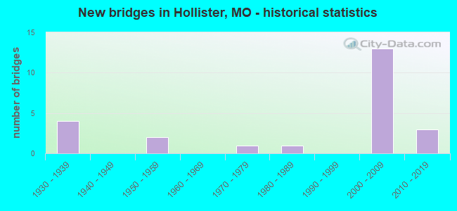
- New bridges - historical statistics
- 41930-1939
- 21950-1959
- 11970-1979
- 11980-1989
- 132000-2009
- 32010-2019

- Reconstructed bridges - Historical Statistics
- 21980-1989
- 01990-1999
- 12000-2009
- 12010-2019


- Bridge Condition - Deck
- 8.3%Very good
- 41.7%Good
- 25.0%Satisfactory
- 8.3%Fair
- 8.3%Poor
- 8.3%Serious

- Bridge Condition - Superstructure
- 8.3%Excellent
- 25.0%Very good
- 16.7%Good
- 16.7%Satisfactory
- 8.3%Fair
- 25.0%Poor

- Bridge Condition - Substructure
- 16.7%Excellent
- 16.7%Very good
- 33.3%Good
- 8.3%Satisfactory
- 16.7%Fair
- 8.3%Poor

- Bridge Condition - Channel
- 10.0%Very good
- 70.0%Good
- 20.0%Satisfactory

- Bridge Condition - Culverts
- 66.7%Good
- 33.3%Satisfactory
Find on map >> Show street view
Structure Number: 3049, Location: S 8 T 22 N R 21 W (Lat: 36.618653, Lng: -93.225336), Route carried "on" structure: Business State highway 65, Year Built: 2005, Status: Open, Structure Length: 10.88m (35.70ft), Average Daily Traffic: 10,630 (year 2021), Truck Traffic: 2%, Average Future Daily Traffic: 24,981 (year 2041), Design Load: HS 20, Features Intersected: US 65
Minimum Vertical Clearance: 30+ m (98+ ft), Kilometerpoint: 5.023, Lanes on structure: 5, Lanes under structure: 4, Owner: State Highway Agency, Approaching Roadway Width: 18.3m (60.0ft), Skew: 4 degrees, Material/Design: Steel continuous, Design/Construction: Stringer/Multi-beam, Number Of Spans In Main Unit: 4, Length of Maximum Span: 36.6m (120.1ft), Curb-To-Curb Width: 19.8m (65.0ft), Out-to-Out Width: 20.6m (67.6ft)
Condition: Deck: Good, Superstructure: Satisfactory, Substructure: Good, Operating Rating: 64.8 metric tons, Method Used To Determine Operating Rating: Load Factor (LF), Inventory Rating: 38.7 metric tons, Method Used To Determine Inventory Rating: Load Factor (LF), Structural Evaluation: Equal to present minimum criteria, Deck Geometry: Meets minimum limits, Underclear: Better than present minimum criteria, Approach Roadway Alignment: Equal to present desirable criteria, Designated Inspection Frequency: Every 24 months, Inspection Date: June 2020, Deck Structure Type: Concrete Cast-file-Place, Wearing Surface/Protective System: Wearing Surface: Monolithic Concrete, Deck Protection: Epoxy Coated Reinforcing
Find on map >> Show street view
Structure Number: 30491, Location: S 17 T 22 N R 21 W (Lat: 36.610503, Lng: -93.232392), Route carried "on" structure: US 65, Year Built: 2005, Status: Open, Structure Length: 11.08m (36.35ft), Average Daily Traffic: 14,376 (year 2021), Truck Traffic: 8%, Average Future Daily Traffic: 25,158 (year 2041), Design Load: HS 25 or greater, Features Intersected: RP BU65E TO US65S, RP
Minimum Vertical Clearance: 30+ m (98+ ft), Kilometerpoint: 489.446, Lanes on structure: 2, Lanes under structure: 10, Base Highway Network: Yes, Owner: State Highway Agency, Approaching Roadway Width: 11.6m (38.1ft), Material/Design: Steel continuous, Design/Construction: Stringer/Multi-beam, Number Of Spans In Main Unit: 3, Length of Maximum Span: 53.6m (175.9ft), Curb-To-Curb Width: 11.6m (38.1ft), Out-to-Out Width: 12.4m (40.7ft)
Condition: Deck: Good, Superstructure: Very good, Substructure: Excellent, Operating Rating: 85.5 metric tons, Method Used To Determine Operating Rating: Load Factor (LF), Inventory Rating: 51.3 metric tons, Method Used To Determine Inventory Rating: Load Factor (LF), Structural Evaluation: Equal to present desirable criteria, Deck Geometry: Equal to present minimum criteria, Underclear: Superior to present desirable criteria, Approach Roadway Alignment: Equal to present desirable criteria, Designated Inspection Frequency: Every 24 months, Inspection Date: June 2020, Deck Structure Type: Concrete Cast-file-Place, Wearing Surface/Protective System: Wearing Surface: Monolithic Concrete, Deck Protection: Epoxy Coated Reinforcing
Find on map >> Show street view
Structure Number: 30492, Location: S 17 T 22 N R 21 W (Lat: 36.610389, Lng: -93.232144), Route carried "on" structure: US 65, Year Built: 2005, Status: Open, Structure Length: 11.08m (36.35ft), Average Daily Traffic: 10,209 (year 2021), Truck Traffic: 17%, Average Future Daily Traffic: 17,866 (year 2041), Design Load: HS 25 or greater, Features Intersected: RP BU65E TO US65N, RP
Minimum Vertical Clearance: 30+ m (98+ ft), Kilometerpoint: 14.256, Lanes on structure: 2, Lanes under structure: 10, Base Highway Network: Yes, Owner: State Highway Agency, Approaching Roadway Width: 11.6m (38.1ft), Material/Design: Steel continuous, Design/Construction: Stringer/Multi-beam, Number Of Spans In Main Unit: 3, Length of Maximum Span: 53.6m (175.9ft), Curb-To-Curb Width: 11.6m (38.1ft), Out-to-Out Width: 12.4m (40.7ft)
Condition: Deck: Satisfactory, Superstructure: Excellent, Substructure: Excellent, Operating Rating: 85.5 metric tons, Method Used To Determine Operating Rating: Load Factor (LF), Inventory Rating: 51.3 metric tons, Method Used To Determine Inventory Rating: Load Factor (LF), Structural Evaluation: Superior to present desirable criteria, Deck Geometry: Equal to present minimum criteria, Underclear: Superior to present desirable criteria, Approach Roadway Alignment: Equal to present desirable criteria, Designated Inspection Frequency: Every 24 months, Inspection Date: June 2020, Deck Structure Type: Concrete Cast-file-Place, Wearing Surface/Protective System: Wearing Surface: Monolithic Concrete, Deck Protection: Epoxy Coated Reinforcing
Find on map >> Show street view
Structure Number: 30493, Location: S 17 T 22 N R 21 W (Lat: 36.610075, Lng: -93.229931), Route carried "on" structure: City street , Year Built: 2004, Status: Open, Structure Length: 0.64m (2.10ft), Average Daily Traffic: 890 (year 2021), Truck Traffic: 5%, Average Future Daily Traffic: 1,869 (year 2041), Design Load: HS 25 or greater, Features Intersected: UNNAMED TRIBUTARY, Facility Carried by Structure: INDUSTRIAL PARK DR
Minimum Vertical Clearance: 30+ m (98+ ft), Kilometerpoint: 0.320, Lanes on structure: 6, Owner: State Highway Agency, Approaching Roadway Width: 23.8m (78.1ft), Skew: 4 degrees, Material/Design: Concrete continuous, Design/Construction: Culvert, Number Of Spans In Main Unit: 2, Length of Maximum Span: 2.1m (6.9ft)
Condition: Channel: Satisfactory, Culverts: Good, Inventory Rating: 64.8 metric tons, Method Used To Determine Inventory Rating: Load Factor (LF), Structural Evaluation: Better than present minimum criteria, Waterway Adequacy: Superior to present desirable criteria, Approach Roadway Alignment: Equal to present desirable criteria, Designated Inspection Frequency: Every 24 months, Inspection Date: April 2021
Find on map >> Show street view
Structure Number: 31302, Location: S 9 T 22 N R 21 W (Lat: 36.624639, Lng: -93.215917), Route carried "on" structure: City street , Year Built: 2001, Status: Open, Structure Length: 4.04m (13.25ft), Average Daily Traffic: 1,000 (year 2021), Truck Traffic: 10%, Average Future Daily Traffic: 2,000 (year 2041), Features Intersected: TURKEY CR, Facility Carried by Structure: ST. JAMES ST
Minimum Vertical Clearance: 30+ m (98+ ft), Kilometerpoint: 0.000, Lanes on structure: 2, Owner: City or Municipal Highway Agency, Approaching Roadway Width: 8.5m (27.9ft), Material/Design: Concrete continuous, Design/Construction: Culvert, Number Of Spans In Main Unit: 3, Length of Maximum Span: 13.6m (44.6ft), Curb or Sidewalk Widths: Left: 0.2m (0.7ft), Right: 1.7m (5.6ft), Curb-To-Curb Width: 8.5m (27.9ft), Out-to-Out Width: 10.4m (34.1ft)
Condition: Channel: Good, Culverts: Good, Operating Rating: 54.0 metric tons, Method Used To Determine Operating Rating: Load Factor (LF), Inventory Rating: 32.4 metric tons, Method Used To Determine Inventory Rating: Load Factor (LF), Structural Evaluation: Better than present minimum criteria, Deck Geometry: Somewhat better than minimum adequacy, Waterway Adequacy: Equal to present desirable criteria, Approach Roadway Alignment: Equal to present desirable criteria, Designated Inspection Frequency: Every 24 months, Inspection Date: Febuary 2021
Find on map >> Show street view
Structure Number: 32105, Location: S 19 T 22 N R 21 W (Lat: 36.593947, Lng: -93.258386), Route carried "on" structure: County highway , Year Built: 1933, Status: Open, Structure Length: 1.19m (3.90ft), Average Daily Traffic: 4,928 (year 2021), Truck Traffic: 10%, Average Future Daily Traffic: 9,856 (year 2041), Design Load: H 10, Features Intersected: SHORT CR, Facility Carried by Structure: OLD HISTORIC 165
Minimum Vertical Clearance: 30+ m (98+ ft), Kilometerpoint: 0.000, Lanes on structure: 2, Owner: County Highway Agency, Approaching Roadway Width: 7.0m (23.0ft), Skew: 1 degrees, Material/Design: Concrete continuous, Design/Construction: Culvert, Number Of Spans In Main Unit: 3, Length of Maximum Span: 3.7m (12.1ft), Curb-To-Curb Width: 10.4m (34.1ft), Out-to-Out Width: 11.0m (36.1ft)
Condition: Channel: Good, Culverts: Satisfactory, Operating Rating: 35.1 metric tons, Method Used To Determine Operating Rating: Load Factor (LF), Inventory Rating: 20.7 metric tons, Method Used To Determine Inventory Rating: Load Factor (LF), Structural Evaluation: Somewhat better than minimum adequacy, Deck Geometry: Somewhat better than minimum adequacy, Waterway Adequacy: Equal to present desirable criteria, Approach Roadway Alignment: Equal to present desirable criteria, Designated Inspection Frequency: Every 24 months, Inspection Date: Febuary 2021
Find on map >> Show street view
Structure Number: 33573, Location: S 19 T 22 N R 21 W (Lat: 36.592719, Lng: -93.255581), Route carried "on" structure: City street , Year Built: 1970, Status: Open, Structure Length: 0.61m (2.00ft), Average Daily Traffic: 80 (year 2021), Truck Traffic: 10%, Average Future Daily Traffic: 156 (year 2041), Features Intersected: TRIB TO SHORT CR, Facility Carried by Structure: BRIAR CLIFF RD
Minimum Vertical Clearance: 30+ m (98+ ft), Kilometerpoint: 0.000, Lanes on structure: 2, Owner: County Highway Agency, Approaching Roadway Width: 6.4m (21.0ft), Material/Design: Steel, Design/Construction: Stringer/Multi-beam, Number Of Spans In Main Unit: 1, Length of Maximum Span: 6.1m (20.0ft), Curb-To-Curb Width: 5.8m (19.0ft), Out-to-Out Width: 6.1m (20.0ft)
Condition: Deck: Satisfactory, Superstructure: Good, Substructure: Good, Channel: Good, Operating Rating: 36.0 metric tons, Method Used To Determine Operating Rating: Load Factor (LF), Inventory Rating: 21.6 metric tons, Method Used To Determine Inventory Rating: Load Factor (LF), Structural Evaluation: Equal to present minimum criteria, Deck Geometry: Meets minimum limits, Waterway Adequacy: Better than present minimum criteria, Approach Roadway Alignment: Equal to present desirable criteria, Designated Inspection Frequency: Every 24 months, Inspection Date: Febuary 2021, Deck Structure Type: Concrete Cast-file-Place, Wearing Surface/Protective System: Wearing Surface: Monolithic Concrete
Find on map >> Show street view
Structure Number: 34419, Location: S 9 T 22 N R 21 W (Lat: 36.617978, Lng: -93.218700), Route carried "on" structure: City street , Year Built: 1980, Status: Open, Structure Length: 1.27m (4.17ft), Average Daily Traffic: 600 (year 2021), Truck Traffic: 10%, Average Future Daily Traffic: 1,200 (year 2041), Features Intersected: BR OF TURKEY CR, Facility Carried by Structure: MAPLE ST
Minimum Vertical Clearance: 30+ m (98+ ft), Kilometerpoint: 0.000, Lanes on structure: 2, Owner: County Highway Agency, Approaching Roadway Width: 7.3m (24.0ft), Skew: 4 degrees, Material/Design: Concrete, Design/Construction: Slab, Number Of Spans In Main Unit: 2, Length of Maximum Span: 6.1m (20.0ft), Curb-To-Curb Width: 7.0m (23.0ft), Out-to-Out Width: 7.3m (24.0ft)
Condition: Deck: Good, Superstructure: Good, Substructure: Good, Channel: Good, Operating Rating: 31.5 metric tons, Method Used To Determine Operating Rating: Field evaluation and documented engineering judgment, Inventory Rating: 18.0 metric tons, Method Used To Determine Inventory Rating: Field evaluation and documented engineering judgment, Structural Evaluation: Somewhat better than minimum adequacy, Deck Geometry: Meets minimum limits, Waterway Adequacy: Equal to present desirable criteria, Approach Roadway Alignment: Equal to present minimum criteria, Designated Inspection Frequency: Every 24 months, Inspection Date: Febuary 2021, Deck Structure Type: Concrete Cast-file-Place, Wearing Surface/Protective System: Wearing Surface: Bituminous
Find on map >> Show street view
Structure Number: 34931, Location: S 7 T 21 N R 21 W (Lat: 36.537611, Lng: -93.264444), Route carried "on" structure: County highway 207, Year Built: 2014, Status: Open, Structure Length: 1.05m (3.44ft), Average Daily Traffic: 50 (year 2021), Truck Traffic: 10%, Average Future Daily Traffic: 100 (year 2041), Design Load: HS 20, Features Intersected: ESTATE DR, Facility Carried by Structure: TOP OF THE ROCK RD
Minimum Vertical Clearance: 30+ m (98+ ft), Kilometerpoint: 1.287, Lanes on structure: 2, Lanes under structure: 2, Owner: County Highway Agency, Approaching Roadway Width: 9.1m (29.9ft), Skew: 1 degrees, Material/Design: Steel, Design/Construction: Stringer/Multi-beam, Number Of Spans In Main Unit: 1, Length of Maximum Span: 9.8m (32.2ft), Curb-To-Curb Width: 9.8m (32.2ft), Out-to-Out Width: 9.8m (32.2ft)
Condition: Deck: Very good, Superstructure: Very good, Substructure: Very good, Operating Rating: 34.2 metric tons, Method Used To Determine Operating Rating: Load Factor (LF), Inventory Rating: 20.7 metric tons, Method Used To Determine Inventory Rating: Load Factor (LF), Structural Evaluation: Equal to present minimum criteria, Deck Geometry: Equal to present desirable criteria, Underclear: Meets minimum limits, Approach Roadway Alignment: Equal to present desirable criteria, Designated Inspection Frequency: Every 24 months, Inspection Date: Febuary 2021, Deck Structure Type: Concrete Cast-file-Place, Wearing Surface/Protective System: Wearing Surface: Monolithic Concrete
Find on map >> Show street view
Structure Number: 36042, Location: S 11 T 22 N R 21 W (Lat: 36.626514, Lng: -93.185917), Route carried "on" structure: County highway 121, Year Built: 2019, Status: Open, Structure Length: 8.38m (27.49ft), Average Daily Traffic: 3,000 (year 2021), Truck Traffic: 10%, Average Future Daily Traffic: 6,000 (year 2041), Design Load: HS 20, Features Intersected: COON CR, Facility Carried by Structure: COON CREEK RD
Minimum Vertical Clearance: 30+ m (98+ ft), Kilometerpoint: 1.287, Lanes on structure: 2, Owner: County Highway Agency, Approaching Roadway Width: 9.0m (29.5ft), Skew: 3 degrees, Material/Design: Steel continuous, Design/Construction: Stringer/Multi-beam, Number Of Spans In Main Unit: 3, Length of Maximum Span: 29.0m (95.1ft), Curb-To-Curb Width: 9.6m (31.5ft), Out-to-Out Width: 10.2m (33.5ft)
Condition: Deck: Good, Superstructure: Very good, Substructure: Very good, Channel: Very good, Operating Rating: 50.4 metric tons, Method Used To Determine Operating Rating: Load Factor (LF), Inventory Rating: 38.7 metric tons, Method Used To Determine Inventory Rating: Load Factor (LF), Structural Evaluation: Equal to present desirable criteria, Deck Geometry: Meets minimum limits, Waterway Adequacy: Superior to present desirable criteria, Approach Roadway Alignment: Somewhat better than minimum adequacy, Designated Inspection Frequency: Every 24 months, Inspection Date: Febuary 2021, Deck Structure Type: Concrete Cast-file-Place, Wearing Surface/Protective System: Wearing Surface: Monolithic Concrete, Deck Protection: Epoxy Coated Reinforcing
Find on map >> Show street view
Structure Number: 418, Location: S 15 T 21 N R 22 W (Lat: 36.526997, Lng: -93.303358), Route carried "on" structure: State highway 86, Year Built: 1956, Year Reconstructed: 2005, Status: Open, Structure Length: 47.88m (157.09ft), Average Daily Traffic: 9,789 (year 2021), Truck Traffic: 10%, Average Future Daily Traffic: 23,004 (year 2041), Design Load: H 15, Features Intersected: TABLE ROCK LK
Minimum Vertical Clearance: 4.83m (15.85ft), Kilometerpoint: 171.165, Lanes on structure: 2, Base Highway Network: Yes, Owner: State Highway Agency, Approaching Roadway Width: 6.4m (21.0ft), Material/Design: Steel continuous, Design/Construction: Truss - Thru, Number Of Spans In Main Unit: 3, Number Of Approach Spans: 4, Length of Maximum Span: 146.3m (480.0ft), Curb-To-Curb Width: 6.7m (22.0ft), Out-to-Out Width: 8.4m (27.6ft)
Condition: Deck: Serious, Superstructure: Poor, Substructure: Fair, Channel: Good, Operating Rating: 31.5 metric tons, Method Used To Determine Operating Rating: Load Factor (LF), Inventory Rating: 18.9 metric tons, Method Used To Determine Inventory Rating: Load Factor (LF), Structural Evaluation: Meets minimum limits, Deck Geometry: High priority of replacement, Waterway Adequacy: Equal to present desirable criteria, Approach Roadway Alignment: Equal to present minimum criteria, Length Of Structure Improvement: 4.79m (15.72ft), Designated Inspection Frequency: Every 24 months, Critical Feature Inspection Frequency: Every 24 months, Underwater Inspection Frequency: Every 60 months, Other Special Inspection Frequency: Every 24 months, Inspection Date: July 2021, Critical Feature Inspection Date: July 2021, Underwater Inspection Date: September 2021, Other Special Inspection Date: July 2021, Bridge Improvement Cost: $18,442,000, Roadway Improvement Cost: $1,844,000, Total Project Cost: $27,663,000 ( Estimate for 2022), Deck Structure Type: Concrete Cast-file-Place, Wearing Surface/Protective System: Wearing Surface: Epoxy Overlay
Find on map >> Show street view
Structure Number: 473, Location: S 4 T 22 N R 21 W (Lat: 36.639514, Lng: -93.210558), Route carried "on" structure: State highway 76, Year Built: 1953, Status: Open, Structure Length: 4.82m (15.81ft), Average Daily Traffic: 20,571 (year 2021), Truck Traffic: 3%, Average Future Daily Traffic: 48,342 (year 2041), Design Load: H 15, Features Intersected: COON CR
Minimum Vertical Clearance: 30+ m (98+ ft), Kilometerpoint: 177.336, Lanes on structure: 2, Owner: State Highway Agency, Approaching Roadway Width: 6.4m (21.0ft), Skew: 2 degrees, Material/Design: Concrete, Design/Construction: Tee Beam, Number Of Spans In Main Unit: 3, Length of Maximum Span: 16.0m (52.5ft), Curb-To-Curb Width: 7.9m (25.9ft), Out-to-Out Width: 9.2m (30.2ft)
Condition: Deck: Satisfactory, Superstructure: Fair, Substructure: Satisfactory, Channel: Good, Operating Rating: 32.4 metric tons, Method Used To Determine Operating Rating: Load Factor (LF), Inventory Rating: 19.8 metric tons, Method Used To Determine Inventory Rating: Load Factor (LF), Structural Evaluation: Somewhat better than minimum adequacy, Deck Geometry: High priority of replacement, Waterway Adequacy: Equal to present desirable criteria, Approach Roadway Alignment: Equal to present minimum criteria, Length Of Structure Improvement: 0.58m (1.90ft), Designated Inspection Frequency: Every 24 months, Inspection Date: June 2020, Bridge Improvement Cost: $729,000, Roadway Improvement Cost: $73,000, Total Project Cost: $1,094,000 ( Estimate for 2022), Deck Structure Type: Concrete Cast-file-Place, Wearing Surface/Protective System: Wearing Surface: Bituminous
Find on map >> Show street view
Structure Number: 5492, Location: S 4 T 22 N R 21 W (Lat: 36.636086, Lng: -93.215189), Route carried "on" structure: State highway 76, Year Built: 1931, Year Reconstructed: 2010, Status: Open, Structure Length: 33.13m (108.69ft), Average Daily Traffic: 12,492 (year 2021), Truck Traffic: 2%, Average Future Daily Traffic: 29,356 (year 2041), Design Load: H 15, Features Intersected: MNA RR, WHITE RVR
Minimum Vertical Clearance: 30+ m (98+ ft), Kilometerpoint: 176.325, Lanes on structure: 2, Owner: State Highway Agency, Approaching Roadway Width: 8.8m (28.9ft), Material/Design: Concrete continuous, Design/Construction: Arch - Deck, Number Of Spans In Main Unit: 5, Number Of Approach Spans: 2, Length of Maximum Span: 59.4m (194.9ft), Curb or Sidewalk Widths: Left: 0.0m, Right: 1.5m (4.9ft), Curb-To-Curb Width: 9.1m (29.9ft), Out-to-Out Width: 9.8m (32.2ft)
Condition: Deck: Good, Superstructure: Satisfactory, Substructure: Good, Channel: Satisfactory, Operating Rating: 27.9 metric tons, Method Used To Determine Operating Rating: Load Factor (LF), Inventory Rating: 12.6 metric tons, Method Used To Determine Inventory Rating: Load Factor (LF), Structural Evaluation: High priority of replacement, Deck Geometry: Meets minimum limits, Underclear: Equal to present minimum criteria, Waterway Adequacy: Equal to present desirable criteria, Approach Roadway Alignment: Meets minimum limits, Length Of Structure Improvement: 3.31m (10.86ft), Designated Inspection Frequency: Every 24 months, Underwater Inspection Frequency: Every 60 months, Inspection Date: November 2021, Underwater Inspection Date: August 2021, Bridge Improvement Cost: $5,328,000, Roadway Improvement Cost: $533,000, Total Project Cost: $7,992,000 ( Estimate for 2022), Deck Structure Type: Concrete Cast-file-Place, Wearing Surface/Protective System: Wearing Surface: Monolithic Concrete, Deck Protection: Epoxy Coated Reinforcing
Find on map >> Show street view
Structure Number: 5493, Location: S 9 T 22 N R 22 W (Lat: 36.621442, Lng: -93.215497), Route carried "on" structure: Business State highway 65, Year Built: 1937, Year Reconstructed: 1986, Status: Open, Structure Length: 6.04m (19.82ft), Average Daily Traffic: 10,630 (year 2021), Truck Traffic: 2%, Average Future Daily Traffic: 24,981 (year 2041), Design Load: H 15, Features Intersected: CST DOWNING ST, CST OL
Minimum Vertical Clearance: 30+ m (98+ ft), Kilometerpoint: 4.035, Lanes on structure: 2, Lanes under structure: 4, Owner: State Highway Agency, Approaching Roadway Width: 6.7m (22.0ft), Skew: 3 degrees, Material/Design: Concrete, Design/Construction: Tee Beam, Number Of Spans In Main Unit: 5, Length of Maximum Span: 13.0m (42.7ft), Curb or Sidewalk Widths: Left: 1.5m (4.9ft), Right: 0.0m, Curb-To-Curb Width: 7.6m (24.9ft), Out-to-Out Width: 9.9m (32.5ft)
Condition: Deck: Fair, Superstructure: Poor, Substructure: Poor, Operating Rating: 54.0 metric tons, Method Used To Determine Operating Rating: Load Factor (LF), Inventory Rating: 32.4 metric tons, Method Used To Determine Inventory Rating: Load Factor (LF), Structural Evaluation: Meets minimum limits, Deck Geometry: High priority of replacement, Underclear: High priority of replacement, Approach Roadway Alignment: Equal to present minimum criteria, Length Of Structure Improvement: 0.71m (2.33ft), Designated Inspection Frequency: Every 12 months, Inspection Date: June 2021, Bridge Improvement Cost: $895,000, Roadway Improvement Cost: $89,000, Total Project Cost: $1,342,000 ( Estimate for 2022), Deck Structure Type: Concrete Cast-file-Place, Wearing Surface/Protective System: Wearing Surface: Bituminous
Find on map >> Show street view
Structure Number: 5518, Location: S 9 T 22 N R 21 W (Lat: 36.628600, Lng: -93.218431), Route carried "on" structure: Business State highway 65, Year Built: 1937, Year Reconstructed: 1986, Status: Open, Structure Length: 8.02m (26.31ft), Average Daily Traffic: 10,630 (year 2021), Truck Traffic: 2%, Average Future Daily Traffic: 24,981 (year 2041), Design Load: H 15, Features Intersected: TURKEY CR
Minimum Vertical Clearance: 30+ m (98+ ft), Kilometerpoint: 3.006, Lanes on structure: 2, Owner: State Highway Agency, Approaching Roadway Width: 7.3m (24.0ft), Skew: 3 degrees, Material/Design: Concrete, Design/Construction: Tee Beam, Number Of Spans In Main Unit: 5, Length of Maximum Span: 16.0m (52.5ft), Curb or Sidewalk Widths: Left: 1.5m (4.9ft), Right: 1.5m (4.9ft), Curb-To-Curb Width: 7.3m (24.0ft), Out-to-Out Width: 11.7m (38.4ft)
Condition: Deck: Poor, Superstructure: Poor, Substructure: Fair, Channel: Good, Operating Rating: 47.7 metric tons, Method Used To Determine Operating Rating: Load Factor (LF), Inventory Rating: 28.8 metric tons, Method Used To Determine Inventory Rating: Load Factor (LF), Structural Evaluation: Meets minimum limits, Deck Geometry: High priority of replacement, Waterway Adequacy: Equal to present desirable criteria, Approach Roadway Alignment: Equal to present minimum criteria, Length Of Structure Improvement: 0.90m (2.95ft), Designated Inspection Frequency: Every 24 months, Inspection Date: June 2020, Bridge Improvement Cost: $1,133,000, Roadway Improvement Cost: $113,000, Total Project Cost: $1,699,000 ( Estimate for 2022), Deck Structure Type: Concrete Cast-file-Place, Wearing Surface/Protective System: Wearing Surface: Bituminous
Find on map >> Show street view
Structure Number: 3049, Location: S 8 T 22 N R 21 W (Lat: 36.618653, Lng: -93.225336), Route carried "under" structure: US 65, Year Built: 2005, Structure Length: 0. m, Average Daily Traffic: 13,729 (year 2021), Truck Traffic: 11%, Features Intersected: US 65
Minimum Vertical Clearance: 5.51m (18.08ft), Kilometerpoint: 15.437, Lanes on structure: 5, Lanes under structure: 2, Material/Design: Steel continuous, Design/Construction: Stringer/Multi-beam, Length of Maximum Span: 36.6m (120.1ft)
Find on map >> Show street view
Structure Number: 3049, Location: S 8 T 22 N R 21 W (Lat: 36.618653, Lng: -93.225336), Route carried "under" structure: US 65, Year Built: 2005, Structure Length: 0. m, Average Daily Traffic: 14,376 (year 2021), Truck Traffic: 8%, Features Intersected: US 65
Minimum Vertical Clearance: 5.18m (16.99ft), Kilometerpoint: 488.390, Lanes on structure: 5, Lanes under structure: 2, Material/Design: Steel continuous, Design/Construction: Stringer/Multi-beam, Length of Maximum Span: 36.6m (120.1ft)
Find on map >> Show street view
Structure Number: 30491, Location: S 17 T 22 N R 21 W (Lat: 36.610503, Lng: -93.232392), Route carried "under" structure: Ramp State highway , Year Built: 2005, Structure Length: 0. m, Average Daily Traffic: 3,261 (year 2021), Truck Traffic: 5%, Features Intersected: RP BU65E TO US65S, Facility Carried by Structure: US 65 S
Minimum Vertical Clearance: 5.44m (17.85ft), Kilometerpoint: 0.016, Lanes on structure: 2, Lanes under structure: 2, Material/Design: Steel continuous, Design/Construction: Stringer/Multi-beam, Length of Maximum Span: 53.6m (175.9ft)
Find on map >> Show street view
Structure Number: 30491, Location: S 17 T 22 N R 21 W (Lat: 36.610503, Lng: -93.232392), Route carried "under" structure: Ramp State highway , Year Built: 2005, Structure Length: 0. m, Average Daily Traffic: 5,300 (year 2021), Truck Traffic: 5%, Features Intersected: RP US65S TO BU65E, Facility Carried by Structure: US 65 S
Minimum Vertical Clearance: 5.44m (17.85ft), Kilometerpoint: 0.325, Lanes on structure: 2, Lanes under structure: 2, Material/Design: Steel continuous, Design/Construction: Stringer/Multi-beam, Length of Maximum Span: 53.6m (175.9ft)
Find on map >> Show street view
Structure Number: 30491, Location: S 17 T 22 N R 21 W (Lat: 36.610503, Lng: -93.232392), Route carried "under" structure: Business State highway 65, Year Built: 2005, Structure Length: 0. m, Average Daily Traffic: 935 (year 2021), Truck Traffic: 5%, Features Intersected: BU 65
Minimum Vertical Clearance: 5.41m (17.75ft), Kilometerpoint: 6.643, Lanes on structure: 2, Lanes under structure: 6, Material/Design: Steel continuous, Design/Construction: Stringer/Multi-beam, Length of Maximum Span: 53.6m (175.9ft)
Find on map >> Show street view
Structure Number: 30492, Location: S 17 T 22 N R 21 W (Lat: 36.610389, Lng: -93.232144), Route carried "under" structure: Ramp State highway , Year Built: 2005, Structure Length: 0. m, Average Daily Traffic: 1,217 (year 2021), Truck Traffic: 10%, Features Intersected: RP US65N TO BU65W, Facility Carried by Structure: US 65 N
Minimum Vertical Clearance: 5.44m (17.85ft), Kilometerpoint: 0.423, Lanes on structure: 2, Lanes under structure: 2, Material/Design: Steel continuous, Design/Construction: Stringer/Multi-beam, Length of Maximum Span: 53.6m (175.9ft)
Find on map >> Show street view
Structure Number: 30492, Location: S 17 T 22 N R 21 W (Lat: 36.610389, Lng: -93.232144), Route carried "under" structure: Ramp State highway , Year Built: 2005, Structure Length: 0. m, Average Daily Traffic: 4,708 (year 2021), Truck Traffic: 5%, Features Intersected: RP BU65E TO US65N, Facility Carried by Structure: US 65 N
Minimum Vertical Clearance: 5.44m (17.85ft), Kilometerpoint: 0.013, Lanes on structure: 2, Lanes under structure: 2, Material/Design: Steel continuous, Design/Construction: Stringer/Multi-beam, Length of Maximum Span: 53.6m (175.9ft)
Find on map >> Show street view
Structure Number: 30492, Location: S 17 T 22 N R 21 W (Lat: 36.610389, Lng: -93.232144), Route carried "under" structure: Business State highway 65, Year Built: 2005, Structure Length: 0. m, Average Daily Traffic: 935 (year 2021), Truck Traffic: 5%, Features Intersected: BU 65
Minimum Vertical Clearance: 5.39m (17.68ft), Kilometerpoint: 6.669, Lanes on structure: 2, Lanes under structure: 6, Material/Design: Steel continuous, Design/Construction: Stringer/Multi-beam, Length of Maximum Span: 53.6m (175.9ft)
Find on map >> Show street view
Structure Number: 34931, Location: S 7 T 21 N R 21 W (Lat: 36.537611, Lng: -93.264444), Route carried "under" structure: County highway , Year Built: 2014, Structure Length: 0. m, Average Daily Traffic: 50 (year 2021), Truck Traffic: 10%, Features Intersected: ESTATE DR, Facility Carried by Structure: TOP OF THE ROCK RD
Minimum Vertical Clearance: 4.72m (15.49ft), Kilometerpoint: 0.000, Lanes on structure: 2, Lanes under structure: 2, Material/Design: Steel, Design/Construction: Stringer/Multi-beam, Length of Maximum Span: 9.8m (32.2ft)