Bridge Statistics for Holt, Michigan (MI)
Condition, Traffic, Stress, Structural Evaluation, Project Costs
- National Bridge Inventory (NBI) Statistics
- 32Number of bridges
- 266ft / 81.3mTotal length
- $1,066,000Total costs
- 518,485Total average daily traffic
- 45,063Total average daily truck traffic
- National Bridge Inventory (NBI) Registered Bridges for Holt
- No street view available for this location
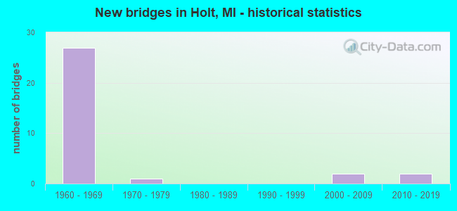
- New bridges - historical statistics
- 271960-1969
- 11970-1979
- 22000-2009
- 22010-2019
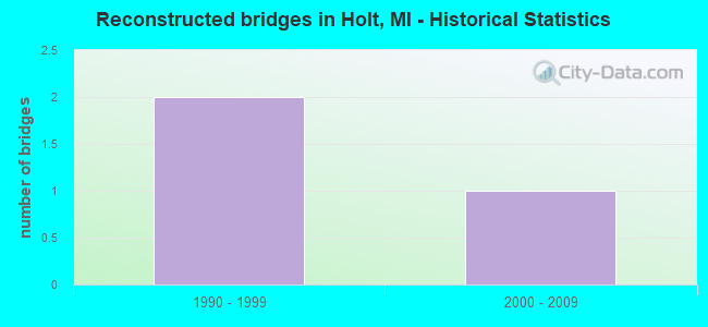
- Reconstructed bridges - Historical Statistics
- 21990-1999
- 12000-2009
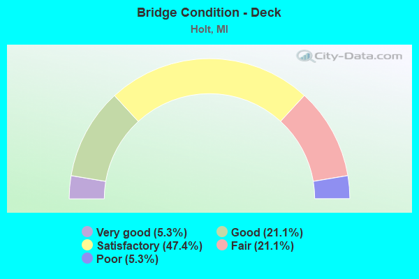
- Bridge Condition - Deck
- 5.3%Very good
- 21.1%Good
- 47.4%Satisfactory
- 21.1%Fair
- 5.3%Poor
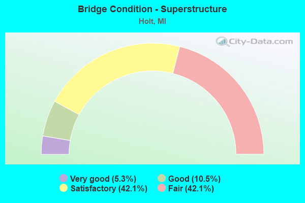
- Bridge Condition - Superstructure
- 5.3%Very good
- 10.5%Good
- 42.1%Satisfactory
- 42.1%Fair
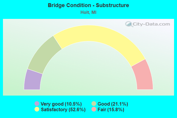
- Bridge Condition - Substructure
- 10.5%Very good
- 21.1%Good
- 52.6%Satisfactory
- 15.8%Fair
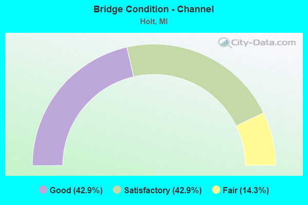
- Bridge Condition - Channel
- 42.9%Good
- 42.9%Satisfactory
- 14.3%Fair
Find on map >> Show street view
Structure Number: 2306, Location: 1.5 MI S OF HOLT RD (Lat: 42.618625, Lng: -84.622725), Route carried "on" structure: State highway 99, Year Built: 1978, Status: Open, Structure Length: 0.94m (3.08ft), Average Daily Traffic: 4,238 (year 2007), Truck Traffic: 4%, Average Future Daily Traffic: 5,508 (year 2018), Design Load: HS 25 or greater, Features Intersected: SKINNER DRAIN
Minimum Vertical Clearance: 30.48m (100.00ft), Kilometerpoint: 8.979, Lanes on structure: 3, Base Highway Network: Yes (Inventory Route: 192, Subroute: 2), Owner: State Highway Agency, Approaching Roadway Width: 13.4m (44.0ft), Skew: 3 degrees, Material/Design: Steel, Design/Construction: Stringer/Multi-beam, Number Of Spans In Main Unit: 1, Length of Maximum Span: 9.4m (30.8ft), Curb-To-Curb Width: 16.8m (55.1ft), Out-to-Out Width: 17.6m (57.7ft)
Condition: Deck: Satisfactory, Superstructure: Fair, Substructure: Satisfactory, Channel: Fair, Operating Rating: 77.1 metric tons, Method Used To Determine Operating Rating: Load Factor (LF) rating reported by rating factor (RF) method using MS18 loading, Inventory Rating: 46.3 metric tons, Method Used To Determine Inventory Rating: Load Factor (LF) rating reported by rating factor (RF) method using MS18 loading, Structural Evaluation: Somewhat better than minimum adequacy, Deck Geometry: Superior to present desirable criteria, Waterway Adequacy: Equal to present desirable criteria, Approach Roadway Alignment: Equal to present desirable criteria, Designated Inspection Frequency: Every 24 months, Inspection Date: May 2021, Deck Structure Type: Concrete Cast-file-Place, Wearing Surface/Protective System: Wearing Surface: Monolithic Concrete
Find on map >> Show street view
Structure Number: 3716, Location: 2.7 MI N OF M-36 (Lat: 42.632636, Lng: -84.476786), Route carried "on" structure: US 127, Year Built: 1966, Status: Open, Structure Length: 2.80m (9.19ft), Average Daily Traffic: 13,964 (year 2007), Truck Traffic: 8%, Average Future Daily Traffic: 16,862 (year 2018), Design Load: HS 20, Features Intersected: SYCAMORE CREEK
Minimum Vertical Clearance: 30.48m (100.00ft), Kilometerpoint: 24.233, Lanes on structure: 2, Base Highway Network: Yes (Inventory Route: 35, Subroute: 6), Owner: State Highway Agency, Approaching Roadway Width: 12.8m (42.0ft), Material/Design: Prestressed concrete, Design/Construction: Stringer/Multi-beam, Number Of Spans In Main Unit: 3, Length of Maximum Span: 9.4m (30.8ft), Curb or Sidewalk Widths: Left: 0.2m (0.7ft), Right: 0.2m (0.7ft), Curb-To-Curb Width: 12.2m (40.0ft), Out-to-Out Width: 12.9m (42.3ft)
Condition: Deck: Satisfactory, Superstructure: Fair, Substructure: Fair, Channel: Satisfactory, Operating Rating: 81.3 metric tons, Method Used To Determine Operating Rating: Load Factor (LF) rating reported by rating factor (RF) method using MS18 loading, Inventory Rating: 48.6 metric tons, Method Used To Determine Inventory Rating: Load Factor (LF) rating reported by rating factor (RF) method using MS18 loading, Structural Evaluation: Somewhat better than minimum adequacy, Deck Geometry: Better than present minimum criteria, Waterway Adequacy: Equal to present desirable criteria, Approach Roadway Alignment: Equal to present desirable criteria, Designated Inspection Frequency: Every 24 months, Inspection Date: June 2020, Deck Structure Type: Concrete Cast-file-Place, Wearing Surface/Protective System: Wearing Surface: Latex Concrete
Find on map >> Show street view
Structure Number: 3719, Location: 1.5 MI N OF M-36 (Lat: 42.619236, Lng: -84.475850), Route carried "on" structure: US 127, Year Built: 1966, Status: Open, Structure Length: 5.42m (17.78ft), Average Daily Traffic: 13,964 (year 2007), Truck Traffic: 8%, Average Future Daily Traffic: 16,862 (year 2018), Design Load: HS 20, Features Intersected: CONRAIL
Minimum Vertical Clearance: 30.48m (100.00ft), Kilometerpoint: 22.734, Lanes on structure: 2, Base Highway Network: Yes (Inventory Route: 35, Subroute: 9), Owner: State Highway Agency, Approaching Roadway Width: 12.8m (42.0ft), Skew: 3 degrees, Material/Design: Steel, Design/Construction: Stringer/Multi-beam, Number Of Spans In Main Unit: 3, Length of Maximum Span: 19.8m (65.0ft), Curb or Sidewalk Widths: Left: 0.2m (0.7ft), Right: 0.2m (0.7ft), Curb-To-Curb Width: 12.2m (40.0ft), Out-to-Out Width: 12.9m (42.3ft)
Condition: Deck: Satisfactory, Superstructure: Fair, Substructure: Good, Operating Rating: 63.8 metric tons, Method Used To Determine Operating Rating: Load Factor (LF) rating reported by rating factor (RF) method using MS18 loading, Inventory Rating: 38.2 metric tons, Method Used To Determine Inventory Rating: Load Factor (LF) rating reported by rating factor (RF) method using MS18 loading, Structural Evaluation: Somewhat better than minimum adequacy, Deck Geometry: Better than present minimum criteria, Approach Roadway Alignment: Equal to present desirable criteria, Length Of Structure Improvement: 5.43m (17.81ft), Designated Inspection Frequency: Every 24 months, Inspection Date: June 2020, Bridge Improvement Cost: $141,000, Roadway Improvement Cost: $10,000, Total Project Cost: $112,000, Deck Structure Type: Concrete Cast-file-Place, Wearing Surface/Protective System: Wearing Surface: Latex Concrete
Find on map >> Show street view
Structure Number: 3722, Location: 1.2 MI N OF M-36 (Lat: 42.611153, Lng: -84.473756), Route carried "on" structure: County highway , Year Built: 1966, Status: Open, Structure Length: 6.74m (22.11ft), Average Daily Traffic: 1,000 (year 1997), Truck Traffic: 1%, Average Future Daily Traffic: 1,150 (year 2017), Design Load: H 15, Features Intersected: US-127, Facility Carried by Structure: HARPER RD
Minimum Vertical Clearance: 30.48m (100.00ft), Kilometerpoint: 4.044, Lanes on structure: 2, Lanes under structure: 4, Owner: State Highway Agency, Approaching Roadway Width: 10.9m (35.8ft), Skew: 2 degrees, Material/Design: Steel, Design/Construction: Stringer/Multi-beam, Number Of Spans In Main Unit: 4, Length of Maximum Span: 23.7m (77.8ft), Curb or Sidewalk Widths: Left: 0.6m (2.0ft), Right: 0.6m (2.0ft), Curb-To-Curb Width: 8.5m (27.9ft), Out-to-Out Width: 10.4m (34.1ft)
Condition: Deck: Fair, Superstructure: Satisfactory, Substructure: Satisfactory, Operating Rating: 70.0 metric tons, Method Used To Determine Operating Rating: Load Factor (LF) rating reported by rating factor (RF) method using MS18 loading, Inventory Rating: 41.8 metric tons, Method Used To Determine Inventory Rating: Load Factor (LF) rating reported by rating factor (RF) method using MS18 loading, Structural Evaluation: Equal to present minimum criteria, Deck Geometry: Somewhat better than minimum adequacy, Underclear: High priority of corrective action, Approach Roadway Alignment: Equal to present desirable criteria, Designated Inspection Frequency: Every 24 months, Inspection Date: June 2020, Bridge Improvement Cost: $105,000, Deck Structure Type: Concrete Cast-file-Place, Wearing Surface/Protective System: Wearing Surface: Integral Concrete
Find on map >> Show street view
Structure Number: 3723, Location: 3.4 MI N OF M-36 (Lat: 42.640275, Lng: -84.478483), Route carried "on" structure: County highway 3366, Year Built: 1966, Year Reconstructed: 2014, Status: Open, Structure Length: 7.60m (24.93ft), Average Daily Traffic: 5,500 (year 1997), Truck Traffic: 1%, Average Future Daily Traffic: 6,325 (year 2017), Design Load: H 20, Features Intersected: US-127, Facility Carried by Structure: HOLT RD
Minimum Vertical Clearance: 5.03m (16.50ft), Kilometerpoint: 10.205, Lanes on structure: 4, Lanes under structure: 4, Owner: State Highway Agency, Approaching Roadway Width: 19.2m (63.0ft), Material/Design: Steel, Design/Construction: Stringer/Multi-beam, Number Of Spans In Main Unit: 4, Length of Maximum Span: 27.7m (90.9ft), Curb-To-Curb Width: 15.8m (51.8ft), Out-to-Out Width: 17.8m (58.4ft)
Condition: Deck: Satisfactory, Superstructure: Satisfactory, Substructure: Satisfactory, Operating Rating: 64.2 metric tons, Method Used To Determine Operating Rating: Load Factor (LF) rating reported by rating factor (RF) method using MS18 loading, Inventory Rating: 38.2 metric tons, Method Used To Determine Inventory Rating: Load Factor (LF) rating reported by rating factor (RF) method using MS18 loading, Structural Evaluation: Equal to present minimum criteria, Deck Geometry: Meets minimum limits, Underclear: Somewhat better than minimum adequacy, Approach Roadway Alignment: Equal to present desirable criteria, Designated Inspection Frequency: Every 24 months, Inspection Date: July 2020, Bridge Improvement Cost: $248,000, Deck Structure Type: Concrete Cast-file-Place, Wearing Surface/Protective System: Wearing Surface: Latex Concrete
Find on map >> Show street view
Structure Number: 3724, Location: 2.0 MI S OF I-96 (Lat: 42.654867, Lng: -84.475958), Route carried "on" structure: US 127, Year Built: 1966, Status: Open, Structure Length: 3.29m (10.79ft), Average Daily Traffic: 16,286 (year 2007), Truck Traffic: 8%, Average Future Daily Traffic: 19,219 (year 2018), Design Load: HS 20, Features Intersected: WILLOUGHBY RD
Minimum Vertical Clearance: 30.48m (100.00ft), Kilometerpoint: 26.745, Lanes on structure: 2, Lanes under structure: 2, Base Highway Network: Yes (Inventory Route: 35, Subroute: 6), Owner: State Highway Agency, Approaching Roadway Width: 12.2m (40.0ft), Material/Design: Steel, Design/Construction: Stringer/Multi-beam, Number Of Spans In Main Unit: 3, Length of Maximum Span: 14.0m (45.9ft), Curb or Sidewalk Widths: Left: 0.2m (0.7ft), Right: 0.2m (0.7ft), Curb-To-Curb Width: 12.2m (40.0ft), Out-to-Out Width: 12.9m (42.3ft)
Condition: Deck: Satisfactory, Superstructure: Satisfactory, Substructure: Satisfactory, Operating Rating: 67.1 metric tons, Method Used To Determine Operating Rating: Load Factor (LF) rating reported by rating factor (RF) method using MS18 loading, Inventory Rating: 40.2 metric tons, Method Used To Determine Inventory Rating: Load Factor (LF) rating reported by rating factor (RF) method using MS18 loading, Structural Evaluation: Equal to present minimum criteria, Deck Geometry: Better than present minimum criteria, Underclear: Meets minimum limits, Approach Roadway Alignment: Equal to present desirable criteria, Length Of Structure Improvement: 3.29m (10.79ft), Designated Inspection Frequency: Every 24 months, Inspection Date: July 2020, Bridge Improvement Cost: $90,000, Roadway Improvement Cost: $6,000, Total Project Cost: $72,000, Deck Structure Type: Concrete Cast-file-Place, Wearing Surface/Protective System: Wearing Surface: Latex Concrete
Find on map >> Show street view
Structure Number: 3725, Location: 2.0 MI S OF I-96 (Lat: 42.654878, Lng: -84.475181), Route carried "on" structure: US 127, Year Built: 1966, Status: Open, Structure Length: 3.29m (10.79ft), Average Daily Traffic: 16,286 (year 2007), Truck Traffic: 8%, Average Future Daily Traffic: 19,219 (year 2018), Design Load: HS 20, Features Intersected: WILLOUGHBY RD
Minimum Vertical Clearance: 30.48m (100.00ft), Kilometerpoint: 26.751, Lanes on structure: 2, Lanes under structure: 2, Base Highway Network: Yes (Inventory Route: 35, Subroute: 9), Owner: State Highway Agency, Approaching Roadway Width: 12.5m (41.0ft), Material/Design: Steel, Design/Construction: Stringer/Multi-beam, Number Of Spans In Main Unit: 3, Length of Maximum Span: 14.0m (45.9ft), Curb or Sidewalk Widths: Left: 0.2m (0.7ft), Right: 0.2m (0.7ft), Curb-To-Curb Width: 12.2m (40.0ft), Out-to-Out Width: 12.9m (42.3ft)
Condition: Deck: Fair, Superstructure: Satisfactory, Substructure: Satisfactory, Operating Rating: 67.7 metric tons, Method Used To Determine Operating Rating: Load Factor (LF) rating reported by rating factor (RF) method using MS18 loading, Inventory Rating: 40.8 metric tons, Method Used To Determine Inventory Rating: Load Factor (LF) rating reported by rating factor (RF) method using MS18 loading, Structural Evaluation: Equal to present minimum criteria, Deck Geometry: Better than present minimum criteria, Underclear: Meets minimum limits, Approach Roadway Alignment: Equal to present desirable criteria, Length Of Structure Improvement: 3.29m (10.79ft), Designated Inspection Frequency: Every 24 months, Inspection Date: July 2020, Bridge Improvement Cost: $90,000, Roadway Improvement Cost: $6,000, Total Project Cost: $72,000, Deck Structure Type: Concrete Cast-file-Place, Wearing Surface/Protective System: Wearing Surface: Integral Concrete
Find on map >> Show street view
Structure Number: 3726, Location: 0.7 MI S OF I-96 (Lat: 42.669089, Lng: -84.483942), Route carried "on" structure: US 127, Year Built: 1966, Status: Open, Structure Length: 4.23m (13.88ft), Average Daily Traffic: 16,286 (year 2007), Truck Traffic: 8%, Average Future Daily Traffic: 19,219 (year 2018), Design Load: HS 20, Features Intersected: COLLEGE RD
Minimum Vertical Clearance: 30.48m (100.00ft), Kilometerpoint: 28.794, Lanes on structure: 2, Lanes under structure: 2, Base Highway Network: Yes (Inventory Route: 35, Subroute: 6), Owner: State Highway Agency, Approaching Roadway Width: 12.5m (41.0ft), Material/Design: Steel, Design/Construction: Stringer/Multi-beam, Number Of Spans In Main Unit: 3, Length of Maximum Span: 20.7m (67.9ft), Curb or Sidewalk Widths: Left: 0.2m (0.7ft), Right: 0.2m (0.7ft), Curb-To-Curb Width: 12.2m (40.0ft), Out-to-Out Width: 12.9m (42.3ft)
Condition: Deck: Fair, Superstructure: Fair, Substructure: Satisfactory, Operating Rating: 65.8 metric tons, Method Used To Determine Operating Rating: Load Factor (LF) rating reported by rating factor (RF) method using MS18 loading, Inventory Rating: 39.5 metric tons, Method Used To Determine Inventory Rating: Load Factor (LF) rating reported by rating factor (RF) method using MS18 loading, Structural Evaluation: Somewhat better than minimum adequacy, Deck Geometry: Better than present minimum criteria, Underclear: Better than present minimum criteria, Approach Roadway Alignment: Equal to present desirable criteria, Length Of Structure Improvement: 4.24m (13.91ft), Designated Inspection Frequency: Every 24 months, Inspection Date: July 2020, Bridge Improvement Cost: $113,000, Roadway Improvement Cost: $8,000, Total Project Cost: $92,000, Deck Structure Type: Concrete Cast-file-Place, Wearing Surface/Protective System: Wearing Surface: Latex Concrete
Find on map >> Show street view
Structure Number: 3727, Location: 0.7 MI S OF I-96 (Lat: 42.669369, Lng: -84.483942), Route carried "on" structure: US 127, Year Built: 1966, Status: Open, Structure Length: 4.08m (13.39ft), Average Daily Traffic: 16,286 (year 2007), Truck Traffic: 8%, Average Future Daily Traffic: 19,219 (year 2018), Design Load: HS 20, Features Intersected: COLLEGE RD
Minimum Vertical Clearance: 30.48m (100.00ft), Kilometerpoint: 28.889, Lanes on structure: 2, Lanes under structure: 2, Base Highway Network: Yes (Inventory Route: 35, Subroute: 9), Owner: State Highway Agency, Approaching Roadway Width: 12.8m (42.0ft), Material/Design: Steel, Design/Construction: Stringer/Multi-beam, Number Of Spans In Main Unit: 3, Length of Maximum Span: 20.7m (67.9ft), Curb or Sidewalk Widths: Left: 0.2m (0.7ft), Right: 0.2m (0.7ft), Curb-To-Curb Width: 12.2m (40.0ft), Out-to-Out Width: 12.9m (42.3ft)
Condition: Deck: Fair, Superstructure: Fair, Substructure: Satisfactory, Operating Rating: 63.8 metric tons, Method Used To Determine Operating Rating: Load Factor (LF) rating reported by rating factor (RF) method using MS18 loading, Inventory Rating: 38.2 metric tons, Method Used To Determine Inventory Rating: Load Factor (LF) rating reported by rating factor (RF) method using MS18 loading, Structural Evaluation: Somewhat better than minimum adequacy, Deck Geometry: Better than present minimum criteria, Underclear: Equal to present minimum criteria, Approach Roadway Alignment: Equal to present desirable criteria, Length Of Structure Improvement: 4.09m (13.42ft), Designated Inspection Frequency: Every 24 months, Inspection Date: July 2020, Bridge Improvement Cost: $110,000, Roadway Improvement Cost: $8,000, Total Project Cost: $90,000, Deck Structure Type: Concrete Cast-file-Place, Wearing Surface/Protective System: Wearing Surface: Latex Concrete
Find on map >> Show street view
Structure Number: 3821, Location: 5.0 MI S OF LANSING (Lat: 42.665494, Lng: -84.518967), Route carried "on" structure: Interstate 96, Year Built: 1962, Status: Open, Structure Length: 4.30m (14.11ft), Average Daily Traffic: 22,885 (year 2014), Truck Traffic: 11%, Average Future Daily Traffic: 26,317 (year 2034), Design Load: HS 20+Mod, Features Intersected: JACKSON AND LANSING RR
Minimum Vertical Clearance: 30.48m (100.00ft), Kilometerpoint: 7.107, Lanes on structure: 2, Base Highway Network: Yes (Inventory Route: 33, Subroute: 4), Owner: State Highway Agency, Approaching Roadway Width: 13.1m (43.0ft), Material/Design: Prestressed concrete, Design/Construction: Stringer/Multi-beam, Number Of Spans In Main Unit: 3, Length of Maximum Span: 13.9m (45.6ft), Curb-To-Curb Width: 11.7m (38.4ft), Out-to-Out Width: 13.3m (43.6ft)
Condition: Deck: Satisfactory, Superstructure: Satisfactory, Substructure: Satisfactory, Operating Rating: 67.4 metric tons, Method Used To Determine Operating Rating: Load Factor (LF) rating reported by rating factor (RF) method using MS18 loading, Inventory Rating: 40.5 metric tons, Method Used To Determine Inventory Rating: Load Factor (LF) rating reported by rating factor (RF) method using MS18 loading, Structural Evaluation: Equal to present minimum criteria, Deck Geometry: Equal to present minimum criteria, Approach Roadway Alignment: Equal to present desirable criteria, Designated Inspection Frequency: Every 24 months, Inspection Date: August 2020, Deck Structure Type: Concrete Cast-file-Place, Wearing Surface/Protective System: Wearing Surface: Latex Concrete
Find on map >> Show street view
Structure Number: 3822, Location: 5.0 MI S OF LANSING (Lat: 42.665753, Lng: -84.519119), Route carried "on" structure: Interstate 96, Year Built: 1962, Status: Open, Structure Length: 4.30m (14.11ft), Average Daily Traffic: 22,885 (year 2014), Truck Traffic: 11%, Average Future Daily Traffic: 26,317 (year 2034), Design Load: HS 20+Mod, Features Intersected: JACKSON AND LANSING RR
Minimum Vertical Clearance: 30.48m (100.00ft), Kilometerpoint: 7.096, Lanes on structure: 2, Base Highway Network: Yes (Inventory Route: 33, Subroute: 10), Owner: State Highway Agency, Approaching Roadway Width: 13.1m (43.0ft), Material/Design: Prestressed concrete, Design/Construction: Stringer/Multi-beam, Number Of Spans In Main Unit: 3, Length of Maximum Span: 13.9m (45.6ft), Curb-To-Curb Width: 11.7m (38.4ft), Out-to-Out Width: 13.3m (43.6ft)
Condition: Deck: Satisfactory, Superstructure: Satisfactory, Substructure: Satisfactory, Operating Rating: 67.4 metric tons, Method Used To Determine Operating Rating: Load Factor (LF) rating reported by rating factor (RF) method using MS18 loading, Inventory Rating: 40.5 metric tons, Method Used To Determine Inventory Rating: Load Factor (LF) rating reported by rating factor (RF) method using MS18 loading, Structural Evaluation: Equal to present minimum criteria, Deck Geometry: Equal to present minimum criteria, Approach Roadway Alignment: Equal to present desirable criteria, Designated Inspection Frequency: Every 24 months, Inspection Date: August 2020, Bridge Improvement Cost: $517,000, Deck Structure Type: Concrete Cast-file-Place, Wearing Surface/Protective System: Wearing Surface: Latex Concrete
Find on map >> Show street view
Structure Number: 3824, Location: I-96 & I-496/US127 INTRCH (Lat: 42.674900, Lng: -84.495131), Route carried "on" structure: Interstate 496, Year Built: 1963, Year Reconstructed: 1997, Status: Open, Structure Length: 4.33m (14.21ft), Average Daily Traffic: 20,400 (year 2020), Truck Traffic: 8%, Average Future Daily Traffic: 22,538 (year 2040), Design Load: HS 25 or greater, Features Intersected: I-96 EB
Minimum Vertical Clearance: 30.48m (100.00ft), Kilometerpoint: 30.083, Lanes on structure: 3, Lanes under structure: 3, Base Highway Network: Yes (Inventory Route: 35, Subroute: 9), Owner: State Highway Agency, Approaching Roadway Width: 15.8m (51.8ft), Material/Design: Prestressed concrete, Design/Construction: Box Beam or Girders - Single/Spread, Number Of Spans In Main Unit: 3, Length of Maximum Span: 21.2m (69.6ft), Curb-To-Curb Width: 13.6m (44.6ft), Out-to-Out Width: 14.6m (47.9ft)
Condition: Deck: Good, Superstructure: Satisfactory, Substructure: Satisfactory, Operating Rating: 78.4 metric tons, Method Used To Determine Operating Rating: Load Factor (LF) rating reported by rating factor (RF) method using MS18 loading, Inventory Rating: 33.7 metric tons, Method Used To Determine Inventory Rating: Load Factor (LF) rating reported by rating factor (RF) method using MS18 loading, Structural Evaluation: Equal to present minimum criteria, Deck Geometry: High priority of corrective action, Underclear: Equal to present minimum criteria, Approach Roadway Alignment: Equal to present desirable criteria, Designated Inspection Frequency: Every 24 months, Inspection Date: September 2020, Deck Structure Type: Concrete Cast-file-Place, Wearing Surface/Protective System: Wearing Surface: Epoxy Overlay, Deck Protection: Epoxy Coated Reinforcing
Find on map >> Show street view
Structure Number: 3826, Location: 5.3 MI SE OF LANSING (Lat: 42.677542, Lng: -84.483986), Route carried "on" structure: County highway 3329, Year Built: 1963, Status: Temporarily open, Structure Length: 6.52m (21.39ft), Average Daily Traffic: 5,200 (year 1995), Truck Traffic: 14%, Average Future Daily Traffic: 24,947 (year 2015), Design Load: H 15, Features Intersected: I-96, Facility Carried by Structure: COLLEGE RD
Minimum Vertical Clearance: 30.48m (100.00ft), Kilometerpoint: 17.037, Lanes on structure: 2, Lanes under structure: 5, Owner: State Highway Agency, Approaching Roadway Width: 11.2m (36.7ft), Material/Design: Prestressed concrete, Design/Construction: Stringer/Multi-beam, Number Of Spans In Main Unit: 4, Length of Maximum Span: 21.3m (69.9ft), Curb-To-Curb Width: 9.5m (31.2ft), Out-to-Out Width: 10.6m (34.8ft)
Condition: Deck: Poor, Superstructure: Fair, Substructure: Fair, Operating Rating: 70.3 metric tons, Method Used To Determine Operating Rating: Load Factor (LF) rating reported by rating factor (RF) method using MS18 loading, Inventory Rating: 39.2 metric tons, Method Used To Determine Inventory Rating: Load Factor (LF) rating reported by rating factor (RF) method using MS18 loading, Structural Evaluation: Somewhat better than minimum adequacy, Deck Geometry: Meets minimum limits, Underclear: Meets minimum limits, Approach Roadway Alignment: Equal to present minimum criteria, Designated Inspection Frequency: Every 24 months, Other Special Inspection Frequency: Every 24 months, Inspection Date: September 2020, Other Special Inspection Date: September 2021, Deck Structure Type: Concrete Cast-file-Place, Wearing Surface/Protective System: Wearing Surface: Monolithic Concrete
Find on map >> Show street view
Structure Number: 3834, Location: I-96 & I-496/US127 INTRCH (Lat: 42.675800, Lng: -84.495647), Route carried "on" structure: Interstate 496, Year Built: 1963, Year Reconstructed: 1997, Status: Open, Structure Length: 4.58m (15.03ft), Average Daily Traffic: 20,400 (year 2020), Truck Traffic: 8%, Average Future Daily Traffic: 22,538 (year 2040), Design Load: HS 25 or greater, Features Intersected: I-96 WB
Minimum Vertical Clearance: 30.48m (100.00ft), Kilometerpoint: 13.612, Lanes on structure: 3, Lanes under structure: 3, Base Highway Network: Yes (Inventory Route: 35, Subroute: 1), Owner: State Highway Agency, Approaching Roadway Width: 16.1m (52.8ft), Skew: 1 degrees, Material/Design: Prestressed concrete, Design/Construction: Box Beam or Girders - Single/Spread, Number Of Spans In Main Unit: 3, Length of Maximum Span: 22.2m (72.8ft), Curb-To-Curb Width: 13.6m (44.6ft), Out-to-Out Width: 14.6m (47.9ft)
Condition: Deck: Good, Superstructure: Satisfactory, Substructure: Good, Operating Rating: 60.3 metric tons, Method Used To Determine Operating Rating: Load Factor (LF) rating reported by rating factor (RF) method using MS18 loading, Inventory Rating: 17.5 metric tons, Method Used To Determine Inventory Rating: Load Factor (LF) rating reported by rating factor (RF) method using MS18 loading, Structural Evaluation: Meets minimum limits, Deck Geometry: High priority of corrective action, Underclear: Meets minimum limits, Approach Roadway Alignment: Equal to present desirable criteria, Designated Inspection Frequency: Every 24 months, Inspection Date: September 2020, Deck Structure Type: Concrete Cast-file-Place, Wearing Surface/Protective System: Wearing Surface: Epoxy Overlay, Deck Protection: Epoxy Coated Reinforcing
Find on map >> Show street view
Structure Number: 3835, Location: I-96 & I-496/US127 INTRCH (Lat: 42.674692, Lng: -84.495606), Route carried "on" structure: Interstate 496, Year Built: 1966, Status: Open, Structure Length: 4.22m (13.85ft), Average Daily Traffic: 16,286 (year 2007), Truck Traffic: 8%, Average Future Daily Traffic: 19,219 (year 2018), Design Load: HS 25 or greater, Features Intersected: I-96 EB
Minimum Vertical Clearance: 30.48m (100.00ft), Kilometerpoint: 30.023, Lanes on structure: 3, Lanes under structure: 3, Base Highway Network: Yes (Inventory Route: 35, Subroute: 6), Owner: State Highway Agency, Approaching Roadway Width: 15.5m (50.9ft), Material/Design: Steel, Design/Construction: Stringer/Multi-beam, Number Of Spans In Main Unit: 3, Length of Maximum Span: 21.1m (69.2ft), Curb-To-Curb Width: 13.5m (44.3ft), Out-to-Out Width: 14.7m (48.2ft)
Condition: Deck: Satisfactory, Superstructure: Fair, Substructure: Good, Operating Rating: 91.4 metric tons, Method Used To Determine Operating Rating: Load Factor (LF), Inventory Rating: 54.8 metric tons, Method Used To Determine Inventory Rating: Load Factor (LF), Structural Evaluation: Somewhat better than minimum adequacy, Deck Geometry: High priority of replacement, Underclear: Somewhat better than minimum adequacy, Approach Roadway Alignment: Equal to present desirable criteria, Designated Inspection Frequency: Every 24 months, Inspection Date: September 2020, Deck Structure Type: Concrete Cast-file-Place, Wearing Surface/Protective System: Wearing Surface: Epoxy Overlay
Find on map >> Show street view
Structure Number: 3862, Location: 8 MILES W OF MASON (Lat: 42.582164, Lng: -84.601133), Route carried "on" structure: County highway 3350, Year Built: 2017, Status: Open, Structure Length: 5.03m (16.50ft), Average Daily Traffic: 4,300 (year 2019), Truck Traffic: 4%, Average Future Daily Traffic: 5,250 (year 2039), Design Load: Greater than HL93, Features Intersected: GRAND RIVER, Facility Carried by Structure: COLUMBIA ROAD
Minimum Vertical Clearance: 30.48m (100.00ft), Kilometerpoint: 0.177, Lanes on structure: 2, Base Highway Network: Yes, Owner: County Highway Agency, Approaching Roadway Width: 9.8m (32.2ft), Material/Design: Steel, Design/Construction: Truss - Thru, Number Of Spans In Main Unit: 1, Length of Maximum Span: 48.8m (160.1ft), Curb-To-Curb Width: 9.8m (32.2ft), Out-to-Out Width: 10.7m (35.1ft)
Condition: Deck: Very good, Superstructure: Very good, Substructure: Very good, Channel: Good, Operating Rating: 54.4 metric tons, Method Used To Determine Operating Rating: Load and Resistance Factor Rating (LRFR) rating reported by rating factor(RF) method using HL-93 loadings, Inventory Rating: 41.8 metric tons, Method Used To Determine Inventory Rating: Load and Resistance Factor Rating (LRFR) rating reported by rating factor(RF) method using HL-93 loadings, Structural Evaluation: Equal to present desirable criteria, Deck Geometry: Meets minimum limits, Waterway Adequacy: Equal to present desirable criteria, Approach Roadway Alignment: Equal to present desirable criteria, Length Of Structure Improvement: 4.82m (15.81ft), Designated Inspection Frequency: Every 24 months, Critical Feature Inspection Frequency: Every 24 months, Inspection Date: July 2021, Critical Feature Inspection Date: July 2021, Bridge Improvement Cost: $484,000, Roadway Improvement Cost: $8,000, Total Project Cost: $492,000, Deck Structure Type: Concrete Cast-file-Place, Wearing Surface/Protective System: Wearing Surface: Monolithic Concrete, Deck Protection: Epoxy Coated Reinforcing
Find on map >> Show street view
Structure Number: 3867, Location: 1 MILE EAST OF HOLT (Lat: 42.640225, Lng: -84.482542), Route carried "on" structure: County highway 3366, Year Built: 1965, Status: Open, Structure Length: 3.20m (10.50ft), Average Daily Traffic: 6,600 (year 2019), Average Future Daily Traffic: 8,060 (year 2039), Design Load: HS 20, Features Intersected: SYCAMORE CREEK, Facility Carried by Structure: HOLT ROAD
Minimum Vertical Clearance: 30.48m (100.00ft), Kilometerpoint: 9.872, Lanes on structure: 4, Base Highway Network: Yes (Inventory Route: 35, Subroute: 7), Owner: County Highway Agency, Approaching Roadway Width: 19.5m (64.0ft), Material/Design: Prestressed concrete, Design/Construction: Stringer/Multi-beam, Number Of Spans In Main Unit: 3, Length of Maximum Span: 10.6m (34.8ft), Curb or Sidewalk Widths: Left: 0.6m (2.0ft), Right: 0.6m (2.0ft), Curb-To-Curb Width: 15.9m (52.2ft), Out-to-Out Width: 17.8m (58.4ft)
Condition: Deck: Good, Superstructure: Fair, Substructure: Fair, Channel: Satisfactory, Operating Rating: 47.6 metric tons, Method Used To Determine Operating Rating: Load Factor (LF) rating reported by rating factor (RF) method using MS18 loading, Inventory Rating: 28.5 metric tons, Method Used To Determine Inventory Rating: Load Factor (LF) rating reported by rating factor (RF) method using MS18 loading, Structural Evaluation: Somewhat better than minimum adequacy, Deck Geometry: Meets minimum limits, Waterway Adequacy: Equal to present desirable criteria, Approach Roadway Alignment: Equal to present desirable criteria, Length Of Structure Improvement: 3.20m (10.50ft), Designated Inspection Frequency: Every 24 months, Inspection Date: May 2021, Bridge Improvement Cost: $136,000, Total Project Cost: $136,000, Deck Structure Type: Concrete Cast-file-Place, Wearing Surface/Protective System: Wearing Surface: Monolithic Concrete
Find on map >> Show street view
Structure Number: 3875, Location: 1 MI E & 2 MI N OF HOLT (Lat: 42.667708, Lng: -84.483964), Route carried "on" structure: County highway 2003, Year Built: 2006, Status: Open, Structure Length: 2.76m (9.06ft), Average Daily Traffic: 6,875 (year 2019), Average Future Daily Traffic: 8,390 (year 2039), Design Load: HS 20, Features Intersected: SYCAMORE CREEK, Facility Carried by Structure: COLLEGE ROAD
Minimum Vertical Clearance: 30.48m (100.00ft), Kilometerpoint: 15.967, Lanes on structure: 2, Owner: County Highway Agency, Approaching Roadway Width: 12.2m (40.0ft), Material/Design: Prestressed concrete, Design/Construction: Box Beam or Girders - Multiple, Number Of Spans In Main Unit: 1, Length of Maximum Span: 26.8m (87.9ft), Curb-To-Curb Width: 12.2m (40.0ft), Out-to-Out Width: 12.9m (42.3ft)
Condition: Deck: Satisfactory, Superstructure: Good, Substructure: Good, Channel: Good, Inventory Rating: 53.1 metric tons, Method Used To Determine Inventory Rating: Load Factor (LF), Structural Evaluation: Better than present minimum criteria, Deck Geometry: Somewhat better than minimum adequacy, Waterway Adequacy: Equal to present desirable criteria, Approach Roadway Alignment: Equal to present desirable criteria, Designated Inspection Frequency: Every 24 months, Inspection Date: May 2021, Deck Structure Type: Concrete Cast-file-Place, Wearing Surface/Protective System: Wearing Surface: Monolithic Concrete, Deck Protection: Epoxy Coated Reinforcing
Find on map >> Show street view
Structure Number: 389, Location: 2.1 MI NE OF HOLT (Lat: 42.654878, Lng: -84.478678), Route carried "on" structure: County highway , Year Built: 2011, Status: Open, Structure Length: 2.56m (8.40ft), Average Daily Traffic: 1,560 (year 2010), Truck Traffic: 1%, Average Future Daily Traffic: 2,320 (year 2030), Design Load: Greater than HL93, Features Intersected: SYCAMORE CREEK, Facility Carried by Structure: WILLOUGHBY ROAD
Minimum Vertical Clearance: 30.48m (100.00ft), Kilometerpoint: 7.073, Lanes on structure: 2, Owner: County Highway Agency, Approaching Roadway Width: 8.5m (27.9ft), Skew: 1 degrees, Material/Design: Prestressed concrete, Design/Construction: Box Beam or Girders - Multiple, Number Of Spans In Main Unit: 1, Length of Maximum Span: 25.2m (82.7ft), Curb-To-Curb Width: 8.8m (28.9ft), Out-to-Out Width: 9.6m (31.5ft)
Condition: Deck: Good, Superstructure: Good, Substructure: Very good, Channel: Satisfactory, Operating Rating: 69.7 metric tons, Method Used To Determine Operating Rating: Load and Resistance Factor Rating (LRFR) rating reported by rating factor(RF) method using HL-93 loadings, Inventory Rating: 44.4 metric tons, Method Used To Determine Inventory Rating: Load and Resistance Factor Rating (LRFR) rating reported by rating factor(RF) method using HL-93 loadings, Structural Evaluation: Better than present minimum criteria, Deck Geometry: Somewhat better than minimum adequacy, Waterway Adequacy: Equal to present desirable criteria, Approach Roadway Alignment: Equal to present desirable criteria, Designated Inspection Frequency: Every 24 months, Inspection Date: October 2021, Deck Structure Type: Concrete Cast-file-Place, Wearing Surface/Protective System: Wearing Surface: Monolithic Concrete, Deck Protection: Epoxy Coated Reinforcing
Find on map >> Show street view
Structure Number: 5418, Location: SEC. 26 ELBA TWP. (Lat: 42.991742, Lng: -83.367458), Route carried "on" structure: ServiceCounty highway , Year Built: 1960, Status: Open, Structure Length: 1.06m (3.48ft), Average Daily Traffic: 225 (year 2018), Average Future Daily Traffic: 275 (year 2038), Design Load: H 20, Features Intersected: FARMERS CREEK, Facility Carried by Structure: MERWIN ROAD
Minimum Vertical Clearance: 30.48m (100.00ft), Kilometerpoint: 4.955, Lanes on structure: 2, Owner: County Highway Agency, Approaching Roadway Width: 9.1m (29.9ft), Material/Design: Steel, Design/Construction: Culvert, Number Of Spans In Main Unit: 2, Length of Maximum Span: 4.5m (14.8ft)
Condition: Channel: Good, Culverts: Satisfactory, Operating Rating: 97.2 metric tons, Method Used To Determine Operating Rating: Load Factor (LF) rating reported by rating factor (RF) method using MS18 loading, Inventory Rating: 78.4 metric tons, Method Used To Determine Inventory Rating: Load Factor (LF) rating reported by rating factor (RF) method using MS18 loading, Structural Evaluation: Equal to present minimum criteria, Waterway Adequacy: Equal to present desirable criteria, Approach Roadway Alignment: Better than present minimum criteria, Designated Inspection Frequency: Every 24 months, Inspection Date: June 2021
Find on map >> Show street view
Structure Number: 3722, Location: 1.2 MI N OF M-36 (Lat: 42.611153, Lng: -84.473756), Route carried "under" structure: US 127, Year Built: 1966, Structure Length: 0. m, Average Daily Traffic: 27,928 (year 2007), Truck Traffic: 8%, Features Intersected: US-127, Facility Carried by Structure: HARPER RD
Minimum Vertical Clearance: 4.55m (14.93ft), Kilometerpoint: 21.804, Lanes on structure: 2, Lanes under structure: 4, Material/Design: Steel, Design/Construction: Stringer/Multi-beam, Length of Maximum Span: 23.7m (77.8ft)
Find on map >> Show street view
Structure Number: 3723, Location: 3.4 MI N OF M-36 (Lat: 42.640275, Lng: -84.478483), Route carried "under" structure: US 127, Year Built: 1966, Structure Length: 0. m, Average Daily Traffic: 40,800 (year 2020), Truck Traffic: 8%, Features Intersected: US-127, Facility Carried by Structure: HOLT RD
Minimum Vertical Clearance: 5.05m (16.57ft), Kilometerpoint: 25.103, Lanes on structure: 4, Lanes under structure: 4, Material/Design: Steel, Design/Construction: Stringer/Multi-beam, Length of Maximum Span: 27.7m (90.9ft)
Find on map >> Show street view
Structure Number: 3724, Location: 2.0 MI S OF I-96 (Lat: 42.654867, Lng: -84.475958), Route carried "under" structure: County highway , Year Built: 1966, Structure Length: 0. m, Average Daily Traffic: 1,400 (year 1997), Truck Traffic: 1%, Features Intersected: WILLOUGHBY RD, Facility Carried by Structure: US-127 SB
Minimum Vertical Clearance: 4.29m (14.07ft), Kilometerpoint: 7.297, Lanes on structure: 2, Lanes under structure: 2, Material/Design: Steel, Design/Construction: Stringer/Multi-beam, Length of Maximum Span: 14.0m (45.9ft)
Find on map >> Show street view
Structure Number: 3725, Location: 2.0 MI S OF I-96 (Lat: 42.654878, Lng: -84.475181), Route carried "under" structure: County highway , Year Built: 1966, Structure Length: 0. m, Average Daily Traffic: 1,400 (year 1997), Truck Traffic: 1%, Features Intersected: WILLOUGHBY RD, Facility Carried by Structure: US-127 NB
Minimum Vertical Clearance: 4.29m (14.07ft), Kilometerpoint: 7.360, Lanes on structure: 2, Lanes under structure: 2, Material/Design: Steel, Design/Construction: Stringer/Multi-beam, Length of Maximum Span: 14.0m (45.9ft)
Find on map >> Show street view
Structure Number: 3726, Location: 0.7 MI S OF I-96 (Lat: 42.669089, Lng: -84.483942), Route carried "under" structure: County highway 3329, Year Built: 1966, Structure Length: 0. m, Average Daily Traffic: 5,200 (year 1995), Truck Traffic: 3%, Features Intersected: COLLEGE RD, Facility Carried by Structure: US-127 SB
Minimum Vertical Clearance: 4.75m (15.58ft), Kilometerpoint: 16.102, Lanes on structure: 2, Lanes under structure: 2, Material/Design: Steel, Design/Construction: Stringer/Multi-beam, Length of Maximum Span: 20.7m (67.9ft)
Find on map >> Show street view
Structure Number: 3727, Location: 0.7 MI S OF I-96 (Lat: 42.669369, Lng: -84.483942), Route carried "under" structure: County highway 3329, Year Built: 1966, Structure Length: 0. m, Average Daily Traffic: 5,200 (year 1995), Truck Traffic: 1%, Features Intersected: COLLEGE RD, Facility Carried by Structure: US-127 NB
Minimum Vertical Clearance: 4.47m (14.67ft), Kilometerpoint: 16.133, Lanes on structure: 2, Lanes under structure: 2, Material/Design: Steel, Design/Construction: Stringer/Multi-beam, Length of Maximum Span: 20.7m (67.9ft)
Find on map >> Show street view
Structure Number: 3824, Location: I-96 & I-496/US127 INTRCH (Lat: 42.674900, Lng: -84.495131), Route carried "under" structure: Interstate 96, Year Built: 1963, Structure Length: 0. m, Average Daily Traffic: 26,002 (year 2007), Truck Traffic: 10%, Features Intersected: I-96 EB
Minimum Vertical Clearance: 5.13m (16.83ft), Kilometerpoint: 9.323, Lanes on structure: 3, Lanes under structure: 3, Material/Design: Prestressed concrete, Design/Construction: Box Beam or Girders - Single/Spread, Length of Maximum Span: 21.2m (69.6ft)
Find on map >> Show street view
Structure Number: 3825, Location: I-96 & I-496/US127 INTRCH (Lat: 42.677178, Lng: -84.492789), Route carried "under" structure: Interstate 96, Year Built: 2008, Structure Length: 0. m, Average Daily Traffic: 52,000 (year 2007), Truck Traffic: 9%, Features Intersected: I-96 WB
Minimum Vertical Clearance: 5.18m (16.99ft), Kilometerpoint: 0.663, Lanes on structure: 2, Lanes under structure: 2, Material/Design: Steel continuous, Design/Construction: Stringer/Multi-beam, Length of Maximum Span: 55.0m (180.4ft)
Find on map >> Show street view
Structure Number: 3826, Location: 5.3 MI SE OF LANSING (Lat: 42.677542, Lng: -84.483986), Route carried "under" structure: Interstate 96, Year Built: 1963, Structure Length: 0. m, Average Daily Traffic: 52,004 (year 2007), Truck Traffic: 10%, Features Intersected: I-96, Facility Carried by Structure: COLLEGE RD
Minimum Vertical Clearance: 4.93m (16.17ft), Kilometerpoint: 10.299, Lanes on structure: 2, Lanes under structure: 5, Material/Design: Prestressed concrete, Design/Construction: Stringer/Multi-beam, Length of Maximum Span: 21.3m (69.9ft)
Find on map >> Show street view
Structure Number: 3834, Location: I-96 & I-496/US127 INTRCH (Lat: 42.675800, Lng: -84.495647), Route carried "under" structure: Interstate 96, Year Built: 1963, Structure Length: 0. m, Average Daily Traffic: 26,002 (year 2007), Truck Traffic: 10%, Features Intersected: I-96 WB
Minimum Vertical Clearance: 5.08m (16.67ft), Kilometerpoint: 9.330, Lanes on structure: 3, Lanes under structure: 3, Material/Design: Prestressed concrete, Design/Construction: Box Beam or Girders - Single/Spread, Length of Maximum Span: 22.2m (72.8ft)
Find on map >> Show street view
Structure Number: 3835, Location: I-96 & I-496/US127 INTRCH (Lat: 42.674692, Lng: -84.495606), Route carried "under" structure: Interstate 96, Year Built: 1966, Structure Length: 0. m, Average Daily Traffic: 26,186 (year 2013), Truck Traffic: 10%, Features Intersected: I-96 EB
Minimum Vertical Clearance: 30+ m (98+ ft), Kilometerpoint: 9.278, Lanes on structure: 3, Lanes under structure: 3, Material/Design: Steel, Design/Construction: Stringer/Multi-beam, Length of Maximum Span: 21.1m (69.2ft)
Find on map >> Show street view
Structure Number: 3836, Location: I-96 & I-496/US127 INTRCH (Lat: 42.675497, Lng: -84.496125), Route carried "under" structure: Interstate 96, Year Built: 1966, Structure Length: 0. m, Average Daily Traffic: 22,937 (year 2007), Truck Traffic: 15%, Features Intersected: I-96 WB
Minimum Vertical Clearance: 4.93m (16.17ft), Kilometerpoint: 9.277, Lanes on structure: 3, Lanes under structure: 3, Material/Design: Steel, Design/Construction: Stringer/Multi-beam, Length of Maximum Span: 21.6m (70.9ft)