Bridge Statistics for Holtville, Alabama (AL)
Condition, Traffic, Stress, Structural Evaluation, Project Costs
- National Bridge Inventory (NBI) Statistics
- 17Number of bridges
- 302ft / 91.8mTotal length
- $24,765,000Total costs
- 16,426Total average daily traffic
- 1,110Total average daily truck traffic
- 19,861Total future (year 2030) average daily traffic
- National Bridge Inventory (NBI) Registered Bridges for Holtville
- No street view available for this location
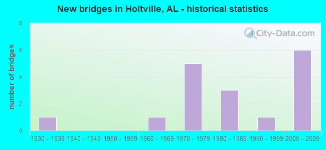
- New bridges - historical statistics
- 11930-1939
- 11960-1969
- 51970-1979
- 31980-1989
- 11990-1999
- 62000-2009


- Bridge Condition - Deck
- 6.3%Very good
- 81.3%Good
- 6.3%Satisfactory
- 6.3%Poor

- Bridge Condition - Superstructure
- 6.3%Very good
- 75.0%Good
- 18.8%Satisfactory

- Bridge Condition - Substructure
- 6.3%Very good
- 62.5%Good
- 31.3%Satisfactory

- Bridge Condition - Channel
- 29.4%Very good
- 64.7%Good
- 5.9%Satisfactory
Find on map >> Show street view
Structure Number: 8298, Location: 1.2 MI E OF AL 143 (Lat: 32.579511, Lng: -86.310292), Route carried "on" structure: County highway 23, Year Built: 1970, Status: Open, Structure Length: 4.05m (13.29ft), Average Daily Traffic: 1,000 (year 1998), Truck Traffic: 20%, Average Future Daily Traffic: 1,130 (year 2031), Design Load: H 15, Features Intersected: CALLOWAY CREEK, Facility Carried by Structure: Ceaserville Road
Minimum Vertical Clearance: 30+ m (98+ ft), Kilometerpoint: 0.010, Lanes on structure: 2, Owner: County Highway Agency, Approaching Roadway Width: 6.7m (22.0ft), Material/Design: Concrete, Design/Construction: Channel Beam, Number Of Spans In Main Unit: 7, Length of Maximum Span: 5.8m (19.0ft), Curb-To-Curb Width: 7.5m (24.6ft), Out-to-Out Width: 7.9m (25.9ft)
Condition: Deck: Good, Superstructure: Good, Substructure: Good, Channel: Good, Operating Rating: 45.9 metric tons, Method Used To Determine Operating Rating: Load Factor (LF), Inventory Rating: 27.5 metric tons, Method Used To Determine Inventory Rating: Load Factor (LF), Structural Evaluation: Equal to present minimum criteria, Deck Geometry: Meets minimum limits, Waterway Adequacy: Equal to present desirable criteria, Approach Roadway Alignment: Better than present minimum criteria, Length Of Structure Improvement: 5.01m (16.44ft), Designated Inspection Frequency: Every 24 months, Inspection Date: September 2021, Bridge Improvement Cost: $859,000, Roadway Improvement Cost: $86,000, Total Project Cost: $945,000 ( Estimate for 2022), Deck Structure Type: Concrete Precast Panels
Find on map >> Show street view
Structure Number: 8868, Location: 8.0 MI.N OF AL 14 (Lat: 32.616667, Lng: -86.276667), Route carried "on" structure: State highway 111, Year Built: 1966, Status: Open, Structure Length: 20.33m (66.70ft), Average Daily Traffic: 5,020 (year 2013), Truck Traffic: 6%, Average Future Daily Traffic: 5,658 (year 2033), Design Load: HS 20, Features Intersected: LAKE JORDAN
Minimum Vertical Clearance: 30+ m (98+ ft), Kilometerpoint: 12.743, Lanes on structure: 2, Owner: State Highway Agency, Approaching Roadway Width: 12.8m (42.0ft), Navigation Control: Yes ( Vertical Clearance: 12.8m (42.0ft), Horizontal Clearance: 45.7m (149.9ft)), Material/Design: Steel continuous, Design/Construction: Girder and Floorbeam System, Number Of Spans In Main Unit: 3, Number Of Approach Spans: 6, Length of Maximum Span: 54.9m (180.1ft), Curb-To-Curb Width: 8.5m (27.9ft), Out-to-Out Width: 9.4m (30.8ft)
Condition: Deck: Poor, Superstructure: Satisfactory, Substructure: Satisfactory, Channel: Satisfactory, Operating Rating: 43.4 metric tons, Method Used To Determine Operating Rating: Load Factor (LF), Inventory Rating: 25.9 metric tons, Method Used To Determine Inventory Rating: Load Factor (LF), Structural Evaluation: Equal to present minimum criteria, Deck Geometry: Meets minimum limits, Waterway Adequacy: Superior to present desirable criteria, Approach Roadway Alignment: Better than present minimum criteria, Length Of Structure Improvement: 20.33m (66.70ft), Designated Inspection Frequency: Every 24 months, Critical Feature Inspection Frequency: Every 24 months, Underwater Inspection Frequency: Every 24 months, Other Special Inspection Frequency: Every 12 months, Inspection Date: September 2021, Critical Feature Inspection Date: September 2021, Underwater Inspection Date: September 2021, Other Special Inspection Date: September 2021, Bridge Improvement Cost: $4,182,000, Roadway Improvement Cost: $418,000, Total Project Cost: $4,600,000 ( Estimate for 2022), Deck Structure Type: Concrete Cast-file-Place
Find on map >> Show street view
Structure Number: 11632, Location: 9.7MI.S.COOSA CO. LINE (Lat: 32.635361, Lng: -86.240489), Route carried "on" structure: US 231, Year Built: 1976, Status: Open, Structure Length: 12.65m (41.50ft), Average Daily Traffic: 5,960 (year 2013), Truck Traffic: 7%, Average Future Daily Traffic: 7,432 (year 2033), Design Load: HS 20, Features Intersected: LAKE JORDAN
Minimum Vertical Clearance: 30+ m (98+ ft), Kilometerpoint: 274.393, Lanes on structure: 2, Base Highway Network: Yes, Owner: State Highway Agency, Approaching Roadway Width: 12.2m (40.0ft), Material/Design: Steel continuous, Design/Construction: Stringer/Multi-beam, Number Of Spans In Main Unit: 4, Number Of Approach Spans: 1, Length of Maximum Span: 85.6m (280.8ft), Curb-To-Curb Width: 13.4m (44.0ft), Out-to-Out Width: 14.3m (46.9ft)
Condition: Deck: Satisfactory, Superstructure: Satisfactory, Substructure: Good, Channel: Good, Operating Rating: 57.0 metric tons, Method Used To Determine Operating Rating: Allowable Stress (AS), Inventory Rating: 36.0 metric tons, Method Used To Determine Inventory Rating: Allowable Stress (AS), Structural Evaluation: Equal to present minimum criteria, Deck Geometry: Equal to present minimum criteria, Waterway Adequacy: Superior to present desirable criteria, Approach Roadway Alignment: Better than present minimum criteria, Length Of Structure Improvement: 13.48m (44.23ft), Designated Inspection Frequency: Every 24 months, Underwater Inspection Frequency: Every 24 months, Inspection Date: August 2020, Underwater Inspection Date: October 2021, Bridge Improvement Cost: $4,253,000, Roadway Improvement Cost: $425,000, Total Project Cost: $4,678,000 ( Estimate for 2022), Deck Structure Type: Concrete Cast-file-Place
Find on map >> Show street view
Structure Number: 1177, Location: SEC 10 T19N R17E (Lat: 32.636667, Lng: -86.360000), Route carried "on" structure: County highway , Year Built: 1977, Status: Open, Structure Length: 2.90m (9.51ft), Average Daily Traffic: 88 (year 2005), Average Future Daily Traffic: 96 (year 2030), Design Load: H 15, Features Intersected: CALLOWAY CREEK N, Facility Carried by Structure: Chase Drive
Minimum Vertical Clearance: 30+ m (98+ ft), Kilometerpoint: 0.010, Lanes on structure: 2, Owner: County Highway Agency, Approaching Roadway Width: 8.5m (27.9ft), Material/Design: Concrete, Design/Construction: Channel Beam, Number Of Spans In Main Unit: 5, Length of Maximum Span: 5.8m (19.0ft), Curb-To-Curb Width: 7.9m (25.9ft), Out-to-Out Width: 8.5m (27.9ft)
Condition: Deck: Good, Superstructure: Good, Substructure: Satisfactory, Channel: Very good, Operating Rating: 45.9 metric tons, Method Used To Determine Operating Rating: Load Factor (LF), Inventory Rating: 27.5 metric tons, Method Used To Determine Inventory Rating: Load Factor (LF), Structural Evaluation: Equal to present minimum criteria, Deck Geometry: Equal to present minimum criteria, Waterway Adequacy: Equal to present desirable criteria, Approach Roadway Alignment: Superior to present desirable criteria, Length Of Structure Improvement: 3.81m (12.50ft), Designated Inspection Frequency: Every 24 months, Inspection Date: Febuary 2021, Bridge Improvement Cost: $706,000, Roadway Improvement Cost: $71,000, Total Project Cost: $777,000 ( Estimate for 2022), Deck Structure Type: Concrete Precast Panels, Wearing Surface/Protective System: Wearing Surface: Bituminous
Find on map >> Show street view
Structure Number: 11807, Location: SEC 22 T19N R17E (Lat: 32.610000, Lng: -86.346667), Route carried "on" structure: County highway 19, Year Built: 1977, Status: Open, Structure Length: 4.05m (13.29ft), Average Daily Traffic: 500 (year 1998), Truck Traffic: 10%, Average Future Daily Traffic: 520 (year 2031), Design Load: H 15, Features Intersected: HURRICANE BRANCH, Facility Carried by Structure: CO RD NO 259
Minimum Vertical Clearance: 30+ m (98+ ft), Kilometerpoint: 0.010, Lanes on structure: 2, Owner: County Highway Agency, Approaching Roadway Width: 8.5m (27.9ft), Material/Design: Concrete, Design/Construction: Channel Beam, Number Of Spans In Main Unit: 7, Length of Maximum Span: 5.8m (19.0ft), Curb-To-Curb Width: 7.9m (25.9ft), Out-to-Out Width: 8.5m (27.9ft)
Condition: Deck: Good, Superstructure: Satisfactory, Substructure: Satisfactory, Channel: Good, Operating Rating: 45.9 metric tons, Method Used To Determine Operating Rating: Load Factor (LF), Inventory Rating: 27.5 metric tons, Method Used To Determine Inventory Rating: Load Factor (LF), Structural Evaluation: Equal to present minimum criteria, Deck Geometry: Somewhat better than minimum adequacy, Waterway Adequacy: Equal to present desirable criteria, Approach Roadway Alignment: Better than present minimum criteria, Length Of Structure Improvement: 5.01m (16.44ft), Designated Inspection Frequency: Every 24 months, Inspection Date: October 2021, Bridge Improvement Cost: $928,000, Roadway Improvement Cost: $93,000, Total Project Cost: $1,021,000 ( Estimate for 2022), Deck Structure Type: Concrete Precast Panels, Wearing Surface/Protective System: Wearing Surface: Bituminous
Find on map >> Show street view
Structure Number: 11994, Location: SEC 23 T19N R17E (Lat: 32.616667, Lng: -86.331667), Route carried "on" structure: County highway 19, Year Built: 1978, Status: Open, Structure Length: 4.05m (13.29ft), Average Daily Traffic: 500 (year 1998), Truck Traffic: 15%, Average Future Daily Traffic: 600 (year 2031), Design Load: H 15, Features Intersected: CALLOWAY CREEK, Facility Carried by Structure: CO RD 259
Minimum Vertical Clearance: 30+ m (98+ ft), Kilometerpoint: 0.010, Lanes on structure: 2, Owner: County Highway Agency, Approaching Roadway Width: 8.5m (27.9ft), Material/Design: Concrete, Design/Construction: Channel Beam, Number Of Spans In Main Unit: 7, Length of Maximum Span: 5.8m (19.0ft), Curb-To-Curb Width: 7.9m (25.9ft), Out-to-Out Width: 8.5m (27.9ft)
Condition: Deck: Good, Superstructure: Good, Substructure: Good, Channel: Good, Operating Rating: 45.9 metric tons, Method Used To Determine Operating Rating: Load Factor (LF), Inventory Rating: 27.5 metric tons, Method Used To Determine Inventory Rating: Load Factor (LF), Structural Evaluation: Equal to present minimum criteria, Deck Geometry: Somewhat better than minimum adequacy, Waterway Adequacy: Equal to present desirable criteria, Approach Roadway Alignment: Better than present minimum criteria, Length Of Structure Improvement: 5.01m (16.44ft), Designated Inspection Frequency: Every 24 months, Inspection Date: October 2021, Bridge Improvement Cost: $927,000, Roadway Improvement Cost: $93,000, Total Project Cost: $1,020,000 ( Estimate for 2022), Deck Structure Type: Concrete Precast Panels, Wearing Surface/Protective System: Wearing Surface: Bituminous
Find on map >> Show street view
Structure Number: 13415, Location: SEC 8 T19N R17E (Lat: 32.641667, Lng: -86.380000), Route carried "on" structure: County highway 274, Year Built: 1984, Status: Open, Structure Length: 1.74m (5.71ft), Average Daily Traffic: 30 (year 2005), Average Future Daily Traffic: 50 (year 2030), Design Load: H 15, Features Intersected: CALLOWAY CREEK, Facility Carried by Structure: Foreman Road
Minimum Vertical Clearance: 30+ m (98+ ft), Kilometerpoint: 0.010, Lanes on structure: 2, Owner: County Highway Agency, Approaching Roadway Width: 8.5m (27.9ft), Material/Design: Concrete, Design/Construction: Channel Beam, Number Of Spans In Main Unit: 3, Length of Maximum Span: 5.8m (19.0ft), Curb-To-Curb Width: 7.9m (25.9ft), Out-to-Out Width: 8.5m (27.9ft)
Condition: Deck: Good, Superstructure: Good, Substructure: Good, Channel: Good, Operating Rating: 45.9 metric tons, Method Used To Determine Operating Rating: Load Factor (LF), Inventory Rating: 27.5 metric tons, Method Used To Determine Inventory Rating: Load Factor (LF), Structural Evaluation: Equal to present minimum criteria, Deck Geometry: Equal to present minimum criteria, Waterway Adequacy: Equal to present desirable criteria, Approach Roadway Alignment: Better than present minimum criteria, Length Of Structure Improvement: 2.44m (8.01ft), Designated Inspection Frequency: Every 24 months, Inspection Date: Febuary 2021, Bridge Improvement Cost: $452,000, Roadway Improvement Cost: $45,000, Total Project Cost: $497,000 ( Estimate for 2022), Deck Structure Type: Concrete Precast Panels, Wearing Surface/Protective System: Wearing Surface: Bituminous
Find on map >> Show street view
Structure Number: 13706, Location: SEC 4 T19N R17E (Lat: 32.660000, Lng: -86.363333), Route carried "on" structure: County highway 265, Year Built: 1985, Status: Open, Structure Length: 1.16m (3.81ft), Average Daily Traffic: 100 (year 2005), Average Future Daily Traffic: 90 (year 2032), Design Load: H 20, Features Intersected: SHOAL CREEK, Facility Carried by Structure: COUNTY ROAD NO 26
Minimum Vertical Clearance: 30+ m (98+ ft), Kilometerpoint: 0.010, Lanes on structure: 2, Owner: County Highway Agency, Approaching Roadway Width: 8.5m (27.9ft), Material/Design: Concrete, Design/Construction: Culvert, Number Of Spans In Main Unit: 3, Length of Maximum Span: 3.7m (12.1ft)
Condition: Channel: Good, Culverts: Good, Operating Rating: 78.6 metric tons, Method Used To Determine Operating Rating: Load Factor (LF), Inventory Rating: 47.1 metric tons, Method Used To Determine Inventory Rating: Load Factor (LF), Structural Evaluation: Better than present minimum criteria, Waterway Adequacy: Equal to present desirable criteria, Approach Roadway Alignment: Better than present minimum criteria, Length Of Structure Improvement: 1.83m (6.00ft), Designated Inspection Frequency: Every 24 months, Inspection Date: January 2021, Bridge Improvement Cost: $444,000, Roadway Improvement Cost: $44,000, Total Project Cost: $488,000 ( Estimate for 2022)
Find on map >> Show street view
Structure Number: 13707, Location: SEC 4 T19N R17E (Lat: 32.658333, Lng: -86.363333), Route carried "on" structure: County highway 265, Year Built: 1985, Status: Open, Structure Length: 5.21m (17.09ft), Average Daily Traffic: 100 (year 2004), Average Future Daily Traffic: 90 (year 2032), Design Load: H 15, Features Intersected: SHOAL CREEK, Facility Carried by Structure: COUNTY ROAD NO 26
Minimum Vertical Clearance: 30+ m (98+ ft), Kilometerpoint: 0.010, Lanes on structure: 2, Owner: County Highway Agency, Approaching Roadway Width: 8.5m (27.9ft), Material/Design: Concrete, Design/Construction: Channel Beam, Number Of Spans In Main Unit: 9, Length of Maximum Span: 5.8m (19.0ft), Curb-To-Curb Width: 7.9m (25.9ft), Out-to-Out Width: 8.5m (27.9ft)
Condition: Deck: Good, Superstructure: Good, Substructure: Satisfactory, Channel: Good, Operating Rating: 45.9 metric tons, Method Used To Determine Operating Rating: Load Factor (LF), Inventory Rating: 27.5 metric tons, Method Used To Determine Inventory Rating: Load Factor (LF), Structural Evaluation: Equal to present minimum criteria, Deck Geometry: Equal to present minimum criteria, Waterway Adequacy: Equal to present desirable criteria, Approach Roadway Alignment: Equal to present minimum criteria, Length Of Structure Improvement: 6.23m (20.44ft), Designated Inspection Frequency: Every 24 months, Inspection Date: January 2021, Bridge Improvement Cost: $1,154,000, Roadway Improvement Cost: $115,000, Total Project Cost: $1,269,000 ( Estimate for 2022), Deck Structure Type: Concrete Precast Panels, Wearing Surface/Protective System: Wearing Surface: Bituminous
Find on map >> Show street view
Structure Number: 15071, Location: SEC 29 T20N R17E (Lat: 32.688953, Lng: -86.383825), Route carried "on" structure: County highway , Year Built: 1990, Status: Open, Structure Length: 1.16m (3.81ft), Average Daily Traffic: 15 (year 2005), Average Future Daily Traffic: 25 (year 2030), Design Load: HS 20, Features Intersected: TAN TROUGH CREEK, Facility Carried by Structure: CO RD 442
Minimum Vertical Clearance: 30+ m (98+ ft), Kilometerpoint: 0.010, Lanes on structure: 2, Owner: County Highway Agency, Approaching Roadway Width: 8.5m (27.9ft), Material/Design: Concrete, Design/Construction: Channel Beam, Number Of Spans In Main Unit: 2, Length of Maximum Span: 5.8m (19.0ft), Curb-To-Curb Width: 8.5m (27.9ft), Out-to-Out Width: 9.1m (29.9ft)
Condition: Deck: Good, Superstructure: Good, Substructure: Good, Channel: Good, Operating Rating: 47.4 metric tons, Method Used To Determine Operating Rating: Load Factor (LF), Inventory Rating: 28.4 metric tons, Method Used To Determine Inventory Rating: Load Factor (LF), Structural Evaluation: Better than present minimum criteria, Deck Geometry: Better than present minimum criteria, Waterway Adequacy: Equal to present desirable criteria, Approach Roadway Alignment: Equal to present minimum criteria, Length Of Structure Improvement: 1.83m (6.00ft), Designated Inspection Frequency: Every 24 months, Inspection Date: Febuary 2021, Bridge Improvement Cost: $377,000, Roadway Improvement Cost: $38,000, Total Project Cost: $415,000 ( Estimate for 2022), Deck Structure Type: Concrete Precast Panels
Find on map >> Show street view
Structure Number: 15272, Location: 1.0MI N OF AL 111 (Lat: 32.650075, Lng: -86.316842), Route carried "on" structure: County highway 23, Year Built: 1930, Year Reconstructed: 1991, Status: Posted for load, Structure Length: 10.61m (34.81ft), Average Daily Traffic: 1,400 (year 1998), Truck Traffic: 2%, Average Future Daily Traffic: 1,580 (year 2031), Design Load: H 15, Features Intersected: SHOAL CREEK EMBANKMENT
Minimum Vertical Clearance: 30+ m (98+ ft), Kilometerpoint: 0.010, Lanes on structure: 2, Owner: County Highway Agency, Approaching Roadway Width: 9.1m (29.9ft), Material/Design: Steel, Design/Construction: Stringer/Multi-beam, Number Of Spans In Main Unit: 6, Length of Maximum Span: 17.6m (57.7ft), Curb-To-Curb Width: 8.5m (27.9ft), Out-to-Out Width: 9.2m (30.2ft)
Condition: Deck: Good, Superstructure: Good, Substructure: Satisfactory, Channel: Good, Operating Rating: 32.7 metric tons, Method Used To Determine Operating Rating: Load Factor (LF), Inventory Rating: 19.6 metric tons, Method Used To Determine Inventory Rating: Load Factor (LF), Structural Evaluation: Somewhat better than minimum adequacy, Deck Geometry: Somewhat better than minimum adequacy, Waterway Adequacy: Better than present minimum criteria, Approach Roadway Alignment: Better than present minimum criteria, Bridge Posting: Required (Relationship of Operating Rating to Maximum Legal Load: 10.0 - 19.9% below), Length Of Structure Improvement: 11.52m (37.80ft), Designated Inspection Frequency: Every 24 months, Underwater Inspection Frequency: Every 48 months, Other Special Inspection Frequency: Every 12 months, Inspection Date: January 2022, Underwater Inspection Date: August 2018, Other Special Inspection Date: December 2021, Bridge Improvement Cost: $2,369,000, Roadway Improvement Cost: $237,000, Total Project Cost: $2,606,000 ( Estimate for 2022), Deck Structure Type: Concrete Cast-file-Place
Find on map >> Show street view
Structure Number: 17993, Location: 1.1 M. W. OF AL. 143 (Lat: 32.616722, Lng: -86.333444), Route carried "on" structure: County highway 257, Year Built: 2001, Status: Open, Structure Length: 1.74m (5.71ft), Average Daily Traffic: 60 (year 2001), Average Future Daily Traffic: 80 (year 2031), Design Load: HS 20, Features Intersected: CALLOWAY CREEK, Facility Carried by Structure: Fern Road
Minimum Vertical Clearance: 30+ m (98+ ft), Kilometerpoint: 0.010, Lanes on structure: 2, Owner: County Highway Agency, Approaching Roadway Width: 9.1m (29.9ft), Material/Design: Concrete, Design/Construction: Channel Beam, Number Of Spans In Main Unit: 3, Length of Maximum Span: 5.8m (19.0ft), Curb-To-Curb Width: 8.5m (27.9ft), Out-to-Out Width: 9.3m (30.5ft)
Condition: Deck: Good, Superstructure: Good, Substructure: Good, Channel: Good, Operating Rating: 70.0 metric tons, Method Used To Determine Operating Rating: Load Factor (LF), Inventory Rating: 41.9 metric tons, Method Used To Determine Inventory Rating: Load Factor (LF), Structural Evaluation: Better than present minimum criteria, Deck Geometry: Better than present minimum criteria, Waterway Adequacy: Better than present minimum criteria, Approach Roadway Alignment: Better than present minimum criteria, Length Of Structure Improvement: 2.44m (8.01ft), Designated Inspection Frequency: Every 24 months, Inspection Date: October 2021, Bridge Improvement Cost: $502,000, Roadway Improvement Cost: $50,000, Total Project Cost: $552,000 ( Estimate for 2022), Deck Structure Type: Concrete Precast Panels
Find on map >> Show street view
Structure Number: 18014, Location: 1 MI E OF AL 143 (Lat: 32.616667, Lng: -86.333333), Route carried "on" structure: County highway 284, Year Built: 2001, Status: Open, Structure Length: 1.74m (5.71ft), Average Daily Traffic: 220 (year 2000), Average Future Daily Traffic: 330 (year 2031), Design Load: HS 20, Features Intersected: CALLOWAY CREEK, Facility Carried by Structure: Carpenter Road
Minimum Vertical Clearance: 30.18m (99.02ft), Kilometerpoint: 0.010, Lanes on structure: 2, Owner: County Highway Agency, Approaching Roadway Width: 8.5m (27.9ft), Material/Design: Concrete, Design/Construction: Channel Beam, Number Of Spans In Main Unit: 3, Length of Maximum Span: 5.8m (19.0ft), Curb-To-Curb Width: 8.5m (27.9ft), Out-to-Out Width: 9.1m (29.9ft)
Condition: Deck: Good, Superstructure: Good, Substructure: Good, Channel: Very good, Operating Rating: 70.0 metric tons, Method Used To Determine Operating Rating: Load Factor (LF), Inventory Rating: 41.9 metric tons, Method Used To Determine Inventory Rating: Load Factor (LF), Structural Evaluation: Better than present minimum criteria, Deck Geometry: Equal to present minimum criteria, Waterway Adequacy: Equal to present desirable criteria, Approach Roadway Alignment: Better than present minimum criteria, Length Of Structure Improvement: 2.44m (8.01ft), Designated Inspection Frequency: Every 24 months, Inspection Date: October 2021, Bridge Improvement Cost: $502,000, Roadway Improvement Cost: $50,000, Total Project Cost: $552,000 ( Estimate for 2022), Deck Structure Type: Concrete Precast Panels
Find on map >> Show street view
Structure Number: 19257, Location: SEC 33 T20N R17E (Lat: 32.671114, Lng: -86.376756), Route carried "on" structure: County highway 277, Year Built: 2005, Status: Open, Structure Length: 2.90m (9.51ft), Average Daily Traffic: 30 (year 2005), Average Future Daily Traffic: 50 (year 2030), Design Load: HS 20, Features Intersected: TAN TROUGH CREEK, Facility Carried by Structure: LOCUST LEVEL RD.
Minimum Vertical Clearance: 30.18m (99.02ft), Kilometerpoint: 0.000, Lanes on structure: 2, Owner: County Highway Agency, Approaching Roadway Width: 8.5m (27.9ft), Material/Design: Concrete, Design/Construction: Channel Beam, Number Of Spans In Main Unit: 5, Length of Maximum Span: 5.8m (19.0ft), Curb-To-Curb Width: 8.5m (27.9ft), Out-to-Out Width: 9.3m (30.5ft)
Condition: Deck: Good, Superstructure: Good, Substructure: Good, Channel: Very good, Operating Rating: 62.4 metric tons, Method Used To Determine Operating Rating: Load Factor (LF), Inventory Rating: 37.4 metric tons, Method Used To Determine Inventory Rating: Load Factor (LF), Structural Evaluation: Better than present minimum criteria, Deck Geometry: Better than present minimum criteria, Waterway Adequacy: Better than present minimum criteria, Approach Roadway Alignment: Better than present minimum criteria, Length Of Structure Improvement: 3.81m (12.50ft), Designated Inspection Frequency: Every 24 months, Inspection Date: Febuary 2021, Bridge Improvement Cost: $783,000, Roadway Improvement Cost: $78,000, Total Project Cost: $861,000 ( Estimate for 2022), Deck Structure Type: Concrete Precast Panels
Find on map >> Show street view
Structure Number: 19258, Location: SEC 13 T20N R17E (Lat: 32.676892, Lng: -86.401719), Route carried "on" structure: County highway 442, Year Built: 2005, Status: Open, Structure Length: 2.32m (7.61ft), Average Daily Traffic: 30 (year 2005), Average Future Daily Traffic: 50 (year 2030), Design Load: HS 20, Features Intersected: WOLF CREEK, Facility Carried by Structure: POSSUM TROT RD.
Minimum Vertical Clearance: 30.18m (99.02ft), Kilometerpoint: 0.000, Lanes on structure: 2, Owner: County Highway Agency, Approaching Roadway Width: 8.5m (27.9ft), Material/Design: Concrete, Design/Construction: Channel Beam, Number Of Spans In Main Unit: 4, Length of Maximum Span: 5.8m (19.0ft), Curb-To-Curb Width: 8.5m (27.9ft), Out-to-Out Width: 9.3m (30.5ft)
Condition: Deck: Good, Superstructure: Good, Substructure: Good, Channel: Good, Operating Rating: 62.4 metric tons, Method Used To Determine Operating Rating: Load Factor (LF), Inventory Rating: 37.4 metric tons, Method Used To Determine Inventory Rating: Load Factor (LF), Structural Evaluation: Better than present minimum criteria, Deck Geometry: Better than present minimum criteria, Waterway Adequacy: Better than present minimum criteria, Approach Roadway Alignment: Better than present minimum criteria, Length Of Structure Improvement: 3.15m (10.33ft), Designated Inspection Frequency: Every 24 months, Inspection Date: Febuary 2021, Bridge Improvement Cost: $648,000, Roadway Improvement Cost: $65,000, Total Project Cost: $713,000 ( Estimate for 2022), Deck Structure Type: Concrete Precast Panels
Find on map >> Show street view
Structure Number: 19259, Location: SEC 22 T20N R17E (Lat: 32.700286, Lng: -86.360172), Route carried "on" structure: County highway 437, Year Built: 2005, Status: Open, Structure Length: 1.74m (5.71ft), Average Daily Traffic: 40 (year 2005), Average Future Daily Traffic: 50 (year 2032), Design Load: HS 20, Features Intersected: NO NAME CREEK, Facility Carried by Structure: COOSA RIVER RD.
Minimum Vertical Clearance: 30.18m (99.02ft), Kilometerpoint: 0.000, Lanes on structure: 2, Owner: County Highway Agency, Approaching Roadway Width: 8.5m (27.9ft), Material/Design: Concrete, Design/Construction: Channel Beam, Number Of Spans In Main Unit: 3, Length of Maximum Span: 5.8m (19.0ft), Curb-To-Curb Width: 8.5m (27.9ft), Out-to-Out Width: 9.3m (30.5ft)
Condition: Deck: Good, Superstructure: Good, Substructure: Good, Channel: Very good, Operating Rating: 62.4 metric tons, Method Used To Determine Operating Rating: Load Factor (LF), Inventory Rating: 37.4 metric tons, Method Used To Determine Inventory Rating: Load Factor (LF), Structural Evaluation: Better than present minimum criteria, Deck Geometry: Better than present minimum criteria, Waterway Adequacy: Equal to present desirable criteria, Approach Roadway Alignment: Equal to present minimum criteria, Length Of Structure Improvement: 2.44m (8.01ft), Designated Inspection Frequency: Every 24 months, Inspection Date: January 2021, Bridge Improvement Cost: $502,000, Roadway Improvement Cost: $50,000, Total Project Cost: $552,000 ( Estimate for 2022), Deck Structure Type: Steel plate
Find on map >> Show street view
Structure Number: 19659, Location: SEC 32 T20N R18E (Lat: 32.678333, Lng: -86.298333), Route carried "on" structure: County highway 29, Year Built: 2009, Status: Open, Structure Length: 13.41m (44.00ft), Average Daily Traffic: 1,333 (year 2009), Truck Traffic: 3%, Average Future Daily Traffic: 2,030 (year 2030), Design Load: HS 20, Features Intersected: WEOKA CREEK, Facility Carried by Structure: Titus Road
Minimum Vertical Clearance: 30+ m (98+ ft), Kilometerpoint: 0.000, Lanes on structure: 2, Owner: County Highway Agency, Approaching Roadway Width: 8.5m (27.9ft), Material/Design: Prestressed concrete, Design/Construction: Stringer/Multi-beam, Number Of Spans In Main Unit: 4, Length of Maximum Span: 33.5m (109.9ft), Curb-To-Curb Width: 8.5m (27.9ft), Out-to-Out Width: 9.4m (30.8ft)
Condition: Deck: Very good, Superstructure: Very good, Substructure: Very good, Channel: Very good, Operating Rating: 73.9 metric tons, Method Used To Determine Operating Rating: Load Factor (LF), Inventory Rating: 47.4 metric tons, Method Used To Determine Inventory Rating: Load Factor (LF), Structural Evaluation: Equal to present desirable criteria, Deck Geometry: Somewhat better than minimum adequacy, Waterway Adequacy: Somewhat better than minimum adequacy, Approach Roadway Alignment: Somewhat better than minimum adequacy, Length Of Structure Improvement: 14.22m (46.65ft), Designated Inspection Frequency: Every 24 months, Underwater Inspection Frequency: Every 48 months, Inspection Date: July 2021, Underwater Inspection Date: August 2018, Bridge Improvement Cost: $2,926,000, Roadway Improvement Cost: $293,000, Total Project Cost: $3,219,000 ( Estimate for 2022), Deck Structure Type: Concrete Cast-file-Place