Bridge Statistics for Homeacre-Lyndora, Pennsylvania (PA)
Condition, Traffic, Stress, Structural Evaluation, Project Costs
- National Bridge Inventory (NBI) Statistics
- 28Number of bridges
- 174ft / 53.1mTotal length
- $5,228,000Total costs
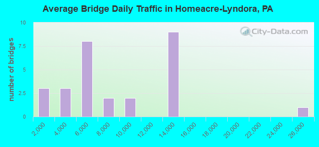
- 219,103Total average daily traffic
- 16,258Total average daily truck traffic
- National Bridge Inventory (NBI) Registered Bridges for Homeacre-Lyndora
- No street view available for this location

- New bridges - historical statistics
- 31930-1939
- 171960-1969
- 11970-1979
- 11980-1989
- 21990-1999
- 32000-2009
- 12010-2019
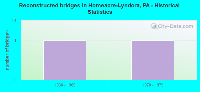
- Reconstructed bridges - Historical Statistics
- 11960-1969
- 11970-1979
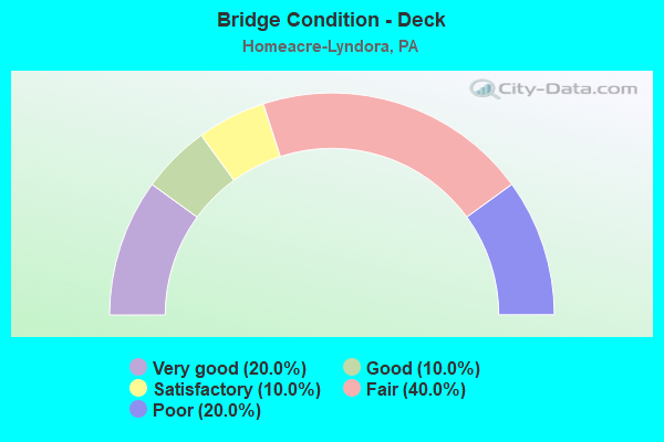
- Bridge Condition - Deck
- 20.0%Very good
- 10.0%Good
- 10.0%Satisfactory
- 40.0%Fair
- 20.0%Poor
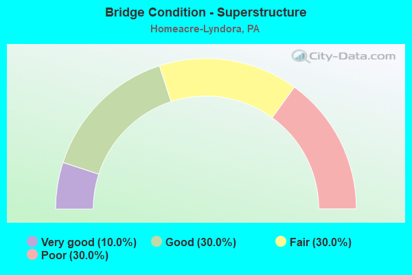
- Bridge Condition - Superstructure
- 10.0%Very good
- 30.0%Good
- 30.0%Fair
- 30.0%Poor
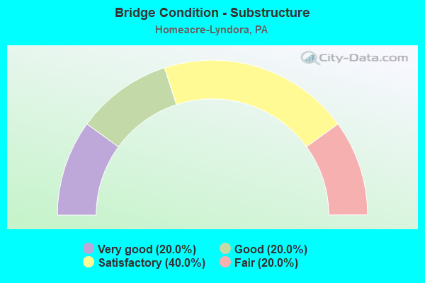
- Bridge Condition - Substructure
- 20.0%Very good
- 20.0%Good
- 40.0%Satisfactory
- 20.0%Fair
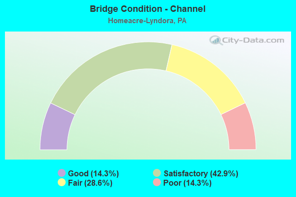
- Bridge Condition - Channel
- 14.3%Good
- 42.9%Satisfactory
- 28.6%Fair
- 14.3%Poor
Find on map >> Show street view
Structure Number: 7844, Location: KARNS CROSSING (Lat: 40.870967, Lng: -79.876269), Route carried "on" structure: State highway 68, Year Built: 1937, Year Reconstructed: 1984, Status: Open, Structure Length: 26.46m (86.81ft), Average Daily Traffic: 9,829 (year 2022), Truck Traffic: 6%, Average Future Daily Traffic: 11,730 (year 2032), Design Load: HS 20+Mod, Features Intersected: B&LE,B&P RRS;CONNOQUE CR
Minimum Vertical Clearance: 4.90m (16.08ft), Kilometerpoint: 32.631, Lanes on structure: 2, Base Highway Network: Yes, Owner: State Highway Agency, Approaching Roadway Width: 10.4m (34.1ft), Skew: 3 degrees, Material/Design: Steel, Design/Construction: Truss - Thru, Number Of Spans In Main Unit: 2, Number Of Approach Spans: 10, Length of Maximum Span: 51.2m (168.0ft), Curb or Sidewalk Widths: Left: 0.2m (0.7ft), Right: 0.2m (0.7ft), Curb-To-Curb Width: 10.4m (34.1ft), Out-to-Out Width: 10.9m (35.8ft)
Condition: Deck: Poor, Superstructure: Poor, Substructure: Fair, Channel: Good, Operating Rating: 65.3 metric tons, Method Used To Determine Operating Rating: Load Factor (LF), Inventory Rating: 39.0 metric tons, Method Used To Determine Inventory Rating: Load Factor (LF), Structural Evaluation: Meets minimum limits, Deck Geometry: Meets minimum limits, Underclear: High priority of corrective action, Waterway Adequacy: Superior to present desirable criteria, Approach Roadway Alignment: Better than present minimum criteria, Length Of Structure Improvement: 26.90m (88.25ft), Designated Inspection Frequency: Every 24 months, Critical Feature Inspection Frequency: Every 24 months, Other Special Inspection Frequency: Every 6 months, Inspection Date: May 2021, Critical Feature Inspection Date: May 2021, Other Special Inspection Date: November 2021, Bridge Improvement Cost: $324,000, Roadway Improvement Cost: $953,000, Total Project Cost: $4,368,000, Deck Structure Type: Concrete Cast-file-Place, Wearing Surface/Protective System: Wearing Surface: Monolithic Concrete, Deck Protection: Epoxy Coated Reinforcing
Find on map >> Show street view
Structure Number: 7845, Location: CONNOQUEN ARCH (Lat: 40.872561, Lng: -79.874594), Route carried "on" structure: State highway 68, Year Built: 1937, Year Reconstructed: 1960, Status: Open, Structure Length: 1.04m (3.41ft), Average Daily Traffic: 9,830 (year 2022), Truck Traffic: 6%, Average Future Daily Traffic: 11,732 (year 2032), Design Load: HS 20, Features Intersected: CONNOQUENESSING CREEK
Minimum Vertical Clearance: 30+ m (98+ ft), Kilometerpoint: 32.977, Lanes on structure: 4, Base Highway Network: Yes, Owner: State Highway Agency, Approaching Roadway Width: 9.4m (30.8ft), Material/Design: Concrete, Design/Construction: Culvert, Number Of Spans In Main Unit: 2, Length of Maximum Span: 10.4m (34.1ft)
Condition: Channel: Satisfactory, Culverts: Satisfactory, Operating Rating: 49.0 metric tons, Method Used To Determine Operating Rating: Field evaluation and documented engineering judgment, Inventory Rating: 32.7 metric tons, Method Used To Determine Inventory Rating: Field evaluation and documented engineering judgment, Structural Evaluation: Equal to present minimum criteria, Waterway Adequacy: Superior to present desirable criteria, Approach Roadway Alignment: Equal to present desirable criteria, Length Of Structure Improvement: 3.00m (9.84ft), Designated Inspection Frequency: Every 48 months, Inspection Date: May 2020, Bridge Improvement Cost: $41,000, Roadway Improvement Cost: $121,000, Total Project Cost: $555,000
Find on map >> Show street view
Structure Number: 7951, Location: MERIDIAN ROAD WB (Lat: 40.884500, Lng: -79.966858), Route carried "on" structure: US 422, Year Built: 1992, Status: Open, Structure Length: 9.14m (29.99ft), Average Daily Traffic: 12,258 (year 2022), Truck Traffic: 8%, Average Future Daily Traffic: 14,725 (year 2032), Design Load: HS 25 or greater, Features Intersected: SR3007 & LT CONNOQ CR
Minimum Vertical Clearance: 30+ m (98+ ft), Kilometerpoint: 19.916, Lanes on structure: 2, Lanes under structure: 2, Base Highway Network: Yes, Owner: State Highway Agency, Approaching Roadway Width: 10.4m (34.1ft), Skew: 30 degrees, Material/Design: Steel continuous, Design/Construction: Stringer/Multi-beam, Number Of Spans In Main Unit: 3, Length of Maximum Span: 45.7m (149.9ft), Curb or Sidewalk Widths: Left: 0.2m (0.7ft), Right: 0.2m (0.7ft), Curb-To-Curb Width: 10.4m (34.1ft), Out-to-Out Width: 11.5m (37.7ft)
Condition: Deck: Satisfactory, Superstructure: Good, Substructure: Good, Channel: Satisfactory, Operating Rating: 78.0 metric tons, Method Used To Determine Operating Rating: Load Factor (LF), Inventory Rating: 46.3 metric tons, Method Used To Determine Inventory Rating: Load Factor (LF), Structural Evaluation: Better than present minimum criteria, Deck Geometry: Meets minimum limits, Underclear: Superior to present desirable criteria, Waterway Adequacy: Superior to present desirable criteria, Approach Roadway Alignment: Equal to present desirable criteria, Length Of Structure Improvement: 10.10m (33.14ft), Designated Inspection Frequency: Every 48 months, Inspection Date: September 2018, Deck Structure Type: Concrete Cast-file-Place, Wearing Surface/Protective System: Wearing Surface: Epoxy Overlay, Membrane: Epoxy, Deck Protection: Epoxy Coated Reinforcing
Find on map >> Show street view
Structure Number: 7952, Location: WEST OF BUTLER (Lat: 40.882228, Lng: -79.952028), Route carried "on" structure: US 422, Year Built: 1962, Status: Open, Structure Length: 3.23m (10.60ft), Average Daily Traffic: 24,649 (year 2022), Truck Traffic: 9%, Average Future Daily Traffic: 28,817 (year 2032), Design Load: HS 20, Features Intersected: SR 0356
Minimum Vertical Clearance: 30+ m (98+ ft), Kilometerpoint: 21.395, Lanes on structure: 4, Lanes under structure: 4, Base Highway Network: Yes, Owner: State Highway Agency, Approaching Roadway Width: 21.0m (68.9ft), Skew: 20 degrees, Material/Design: Prestressed concrete, Design/Construction: Box Beam or Girders - Multiple, Number Of Spans In Main Unit: 2, Length of Maximum Span: 15.5m (50.9ft), Curb or Sidewalk Widths: Left: 0.5m (1.6ft), Right: 0.5m (1.6ft), Curb-To-Curb Width: 25.6m (84.0ft), Out-to-Out Width: 27.3m (89.6ft)
Condition: Deck: Fair, Superstructure: Fair, Substructure: Fair, Operating Rating: 71.7 metric tons, Method Used To Determine Operating Rating: Load Factor (LF), Inventory Rating: 30.8 metric tons, Method Used To Determine Inventory Rating: Load Factor (LF), Structural Evaluation: Somewhat better than minimum adequacy, Deck Geometry: Superior to present desirable criteria, Underclear: High priority of corrective action, Approach Roadway Alignment: Equal to present desirable criteria, Length Of Structure Improvement: 3.20m (10.50ft), Designated Inspection Frequency: Every 24 months, Inspection Date: December 2021, Deck Structure Type: Concrete Cast-file-Place, Wearing Surface/Protective System: Wearing Surface: Bituminous, Membrane: Preformed Fabric
Find on map >> Show street view
Structure Number: 7953, Location: DUFFY ROAD (Lat: 40.881581, Lng: -79.940811), Route carried "on" structure: State highway , Year Built: 1962, Status: Open, Structure Length: 2.16m (7.09ft), Average Daily Traffic: 7,393 (year 2022), Truck Traffic: 8%, Average Future Daily Traffic: 8,673 (year 2032), Design Load: HS 20, Features Intersected: SR0422 EB&WB, Facility Carried by Structure: SR3039
Minimum Vertical Clearance: 30+ m (98+ ft), Kilometerpoint: 0.000, Lanes on structure: 2, Lanes under structure: 4, Owner: State Highway Agency, Approaching Roadway Width: 12.2m (40.0ft), Material/Design: Prestressed concrete, Design/Construction: Box Beam or Girders - Single/Spread, Number Of Spans In Main Unit: 1, Length of Maximum Span: 20.7m (67.9ft), Curb or Sidewalk Widths: Left: 0.5m (1.6ft), Right: 0.5m (1.6ft), Curb-To-Curb Width: 12.2m (40.0ft), Out-to-Out Width: 13.9m (45.6ft)
Condition: Deck: Fair, Superstructure: Fair, Substructure: Satisfactory, Operating Rating: 63.5 metric tons, Method Used To Determine Operating Rating: Load Factor (LF), Inventory Rating: 23.6 metric tons, Method Used To Determine Inventory Rating: Load Factor (LF), Structural Evaluation: Somewhat better than minimum adequacy, Deck Geometry: Somewhat better than minimum adequacy, Underclear: High priority of corrective action, Approach Roadway Alignment: Equal to present desirable criteria, Length Of Structure Improvement: 2.80m (9.19ft), Designated Inspection Frequency: Every 24 months, Inspection Date: July 2020, Deck Structure Type: Concrete Cast-file-Place, Wearing Surface/Protective System: Wearing Surface: Bituminous
Find on map >> Show street view
Structure Number: 8059, Location: BUTLER (Lat: 40.855528, Lng: -79.919108), Route carried "on" structure: State highway , Year Built: 1961, Status: Open, Structure Length: 0.67m (2.20ft), Average Daily Traffic: 7,747 (year 2020), Truck Traffic: 4%, Average Future Daily Traffic: 11,100 (year 2032), Design Load: H 20, Features Intersected: WEST BUTLER CREEK, Facility Carried by Structure: SR3002
Minimum Vertical Clearance: 30+ m (98+ ft), Kilometerpoint: 4.751, Lanes on structure: 2, Owner: State Highway Agency, Approaching Roadway Width: 9.8m (32.2ft), Skew: 4 degrees, Material/Design: Concrete, Design/Construction: Slab, Number Of Spans In Main Unit: 1, Length of Maximum Span: 4.6m (15.1ft), Curb or Sidewalk Widths: Left: 0.5m (1.6ft), Right: 1.5m (4.9ft), Curb-To-Curb Width: 9.8m (32.2ft), Out-to-Out Width: 12.2m (40.0ft)
Condition: Deck: Good, Superstructure: Good, Substructure: Satisfactory, Channel: Poor, Operating Rating: 49.9 metric tons, Method Used To Determine Operating Rating: Load Factor (LF), Inventory Rating: 29.9 metric tons, Method Used To Determine Inventory Rating: Load Factor (LF), Structural Evaluation: Equal to present minimum criteria, Deck Geometry: Meets minimum limits, Waterway Adequacy: Equal to present minimum criteria, Approach Roadway Alignment: Better than present minimum criteria, Length Of Structure Improvement: 1.30m (4.27ft), Designated Inspection Frequency: Every 24 months, Inspection Date: August 2021, Deck Structure Type: Concrete Cast-file-Place, Wearing Surface/Protective System: Wearing Surface: Bituminous
Find on map >> Show street view
Structure Number: 8069, Location: EAST OF MT CHESTNUT (Lat: 40.889061, Lng: -79.961944), Route carried "on" structure: State highway , Year Built: 1938, Status: Open, Structure Length: 0.64m (2.10ft), Average Daily Traffic: 4,639 (year 2022), Truck Traffic: 3%, Average Future Daily Traffic: 5,581 (year 2032), Design Load: H 20, Features Intersected: CROOKED RUN, Facility Carried by Structure: SR 3007
Minimum Vertical Clearance: 30+ m (98+ ft), Kilometerpoint: 17.754, Lanes on structure: 2, Owner: State Highway Agency, Approaching Roadway Width: 5.8m (19.0ft), Skew: 1 degrees, Material/Design: Concrete, Design/Construction: Slab, Number Of Spans In Main Unit: 1, Length of Maximum Span: 5.5m (18.0ft), Curb or Sidewalk Widths: Left: 0.2m (0.7ft), Right: 0.2m (0.7ft), Curb-To-Curb Width: 7.1m (23.3ft), Out-to-Out Width: 8.1m (26.6ft)
Condition: Deck: Poor, Superstructure: Poor, Substructure: Satisfactory, Channel: Fair, Operating Rating: 52.6 metric tons, Method Used To Determine Operating Rating: Load Factor (LF), Inventory Rating: 30.8 metric tons, Method Used To Determine Inventory Rating: Load Factor (LF), Structural Evaluation: Meets minimum limits, Deck Geometry: High priority of replacement, Waterway Adequacy: Equal to present desirable criteria, Approach Roadway Alignment: Better than present minimum criteria, Length Of Structure Improvement: 0.80m (2.62ft), Designated Inspection Frequency: Every 24 months, Inspection Date: November 2021, Bridge Improvement Cost: $15,000, Roadway Improvement Cost: $75,000, Total Project Cost: $206,000, Deck Structure Type: Concrete Cast-file-Place, Wearing Surface/Protective System: Wearing Surface: Bituminous
Find on map >> Show street view
Structure Number: 8109, Location: NW OF BUTLER (Lat: 40.882408, Lng: -79.956275), Route carried "on" structure: State highway , Year Built: 1962, Status: Open, Structure Length: 2.16m (7.09ft), Average Daily Traffic: 2,157 (year 2021), Truck Traffic: 1%, Average Future Daily Traffic: 3,070 (year 2032), Design Load: HS 20, Features Intersected: SR0422 EB&WB, Facility Carried by Structure: SR 3031
Minimum Vertical Clearance: 30+ m (98+ ft), Kilometerpoint: 1.627, Lanes on structure: 2, Lanes under structure: 4, Owner: State Highway Agency, Approaching Roadway Width: 5.8m (19.0ft), Material/Design: Prestressed concrete, Design/Construction: Box Beam or Girders - Single/Spread, Number Of Spans In Main Unit: 1, Length of Maximum Span: 20.7m (67.9ft), Curb or Sidewalk Widths: Left: 0.5m (1.6ft), Right: 0.5m (1.6ft), Curb-To-Curb Width: 8.6m (28.2ft), Out-to-Out Width: 10.2m (33.5ft)
Condition: Deck: Fair, Superstructure: Poor, Substructure: Good, Operating Rating: 68.0 metric tons, Method Used To Determine Operating Rating: Load Factor (LF), Inventory Rating: 18.1 metric tons, Method Used To Determine Inventory Rating: Load Factor (LF), Structural Evaluation: Meets minimum limits, Deck Geometry: Meets minimum limits, Underclear: High priority of corrective action, Approach Roadway Alignment: Equal to present desirable criteria, Length Of Structure Improvement: 3.00m (9.84ft), Designated Inspection Frequency: Every 24 months, Other Special Inspection Frequency: Every 3 months, Inspection Date: September 2021, Other Special Inspection Date: November 2021, Bridge Improvement Cost: $7,000, Roadway Improvement Cost: $22,000, Total Project Cost: $99,000, Deck Structure Type: Concrete Cast-file-Place, Wearing Surface/Protective System: Wearing Surface: Monolithic Concrete, Deck Protection: Epoxy Coated Reinforcing
Find on map >> Show street view
Structure Number: 8153, Location: 0.35 MI SW of SR 422 (Lat: 40.879958, Lng: -79.968792), Route carried "on" structure: City street , Year Built: 1980, Status: Open, Structure Length: 1.19m (3.90ft), Average Daily Traffic: 750 (year 2015), Truck Traffic: 9%, Average Future Daily Traffic: 800 (year 2035), Design Load: HS 20, Features Intersected: LITTLE CONNOQUEN CR, Facility Carried by Structure: GREENWOOD DRIVE
Minimum Vertical Clearance: 30+ m (98+ ft), Kilometerpoint: 0.000, Lanes on structure: 2, Owner: Town or Township Highway Agency, Approaching Roadway Width: 6.7m (22.0ft), Material/Design: Prestressed concrete, Design/Construction: Box Beam or Girders - Multiple, Number Of Spans In Main Unit: 1, Length of Maximum Span: 11.6m (38.1ft), Curb-To-Curb Width: 8.6m (28.2ft), Out-to-Out Width: 9.7m (31.8ft)
Condition: Deck: Fair, Superstructure: Fair, Substructure: Satisfactory, Channel: Fair, Operating Rating: 49.9 metric tons, Method Used To Determine Operating Rating: Load Factor (LF), Inventory Rating: 16.3 metric tons, Method Used To Determine Inventory Rating: Load Factor (LF), Structural Evaluation: Meets minimum limits, Deck Geometry: Somewhat better than minimum adequacy, Waterway Adequacy: Better than present minimum criteria, Approach Roadway Alignment: Equal to present desirable criteria, Length Of Structure Improvement: 1.80m (5.91ft), Designated Inspection Frequency: Every 24 months, Inspection Date: November 2019, Deck Structure Type: Other, Wearing Surface/Protective System: Wearing Surface: Bituminous
Find on map >> Show street view
Structure Number: 45472, Location: 1 mi. West of SR 0008 (Lat: 40.879139, Lng: -79.915289), Route carried "on" structure: State highway , Year Built: 2009, Status: Open, Structure Length: 4.79m (15.72ft), Average Daily Traffic: 2,500 (year 2020), Truck Traffic: 5%, Average Future Daily Traffic: 4,174 (year 2032), Design Load: HL 93, Features Intersected: SR 0422 EB & WB, Facility Carried by Structure: SR 4001
Minimum Vertical Clearance: 30+ m (98+ ft), Kilometerpoint: 0.874, Lanes on structure: 2, Lanes under structure: 4, Owner: State Highway Agency, Approaching Roadway Width: 8.5m (27.9ft), Skew: 2 degrees, Material/Design: Prestressed concrete, Design/Construction: Stringer/Multi-beam, Number Of Spans In Main Unit: 1, Length of Maximum Span: 45.7m (149.9ft), Curb or Sidewalk Widths: Left: 0.1m (0.3ft), Right: 0.1m (0.3ft), Curb-To-Curb Width: 10.4m (34.1ft), Out-to-Out Width: 11.4m (37.4ft)
Condition: Deck: Very good, Superstructure: Good, Substructure: Very good, Operating Rating: 77.1 metric tons, Method Used To Determine Operating Rating: Load and Resistance Factor (LRFR), Inventory Rating: 46.3 metric tons, Method Used To Determine Inventory Rating: Load and Resistance Factor (LRFR), Structural Evaluation: Better than present minimum criteria, Deck Geometry: Somewhat better than minimum adequacy, Underclear: High priority of corrective action, Approach Roadway Alignment: Equal to present desirable criteria, Designated Inspection Frequency: Every 48 months, Inspection Date: September 2021, Deck Structure Type: Concrete Cast-file-Place, Wearing Surface/Protective System: Wearing Surface: Monolithic Concrete, Deck Protection: Epoxy Coated Reinforcing
Find on map >> Show street view
Structure Number: 53229, Location: 0.1 Mi W SR 38 (Lat: 40.885294, Lng: -79.876281), Route carried "on" structure: State highway , Year Built: 2016, Status: Open, Structure Length: 1.58m (5.18ft), Average Daily Traffic: 1,747 (year 2022), Truck Traffic: 3%, Average Future Daily Traffic: 1,677 (year 2032), Design Load: HL 93, Features Intersected: CONNOQUENESSING CREEK, Facility Carried by Structure: SR 1016
Minimum Vertical Clearance: 30+ m (98+ ft), Kilometerpoint: 0.000, Lanes on structure: 2, Owner: State Highway Agency, Approaching Roadway Width: 5.5m (18.0ft), Material/Design: Steel, Design/Construction: Stringer/Multi-beam, Number Of Spans In Main Unit: 1, Length of Maximum Span: 14.9m (48.9ft), Curb-To-Curb Width: 7.5m (24.6ft), Out-to-Out Width: 8.4m (27.6ft)
Condition: Deck: Very good, Superstructure: Very good, Substructure: Very good, Channel: Satisfactory, Operating Rating: 66.1 metric tons, Method Used To Determine Operating Rating: Assigned ratings based on Load and Resistance Factor Design (LRFD) reported by rating factor (RF) using HL93 loadings, Inventory Rating: 51.2 metric tons, Method Used To Determine Inventory Rating: Assigned ratings based on Load and Resistance Factor Design (LRFD) reported by rating factor (RF) using HL93 loadings, Structural Evaluation: Equal to present desirable criteria, Deck Geometry: Meets minimum limits, Waterway Adequacy: Better than present minimum criteria, Approach Roadway Alignment: Better than present minimum criteria, Designated Inspection Frequency: Every 48 months, Inspection Date: January 2020, Deck Structure Type: Concrete Cast-file-Place, Wearing Surface/Protective System: Wearing Surface: Monolithic Concrete, Deck Protection: Epoxy Coated Reinforcing
Find on map >> Show street view
Structure Number: 7782, Location: BON AIRE (Lat: 40.879853, Lng: -79.897525), Route carried "under" structure: US 422, Year Built: 1960, Structure Length: 0. m, Average Daily Traffic: 12,391 (year 2022), Truck Traffic: 10%, Features Intersected: SR0422 EB&WB, Facility Carried by Structure: SR0008 NB&SB
Minimum Vertical Clearance: 6.10m (20.01ft), Kilometerpoint: 26.044, Lanes on structure: 3, Lanes under structure: 3, Material/Design: Prestressed concrete, Design/Construction: Box Beam or Girders - Single/Spread, Length of Maximum Span: 27.7m (90.9ft)
Find on map >> Show street view
Structure Number: 7782, Location: BON AIRE (Lat: 40.879853, Lng: -79.897525), Route carried "under" structure: US 422, Year Built: 1960, Structure Length: 0. m, Average Daily Traffic: 12,258 (year 2022), Truck Traffic: 8%, Features Intersected: SR0422 EB&WB, Facility Carried by Structure: SR0008 NB&SB
Minimum Vertical Clearance: 5.59m (18.34ft), Kilometerpoint: 26.031, Lanes on structure: 3, Lanes under structure: 3, Material/Design: Prestressed concrete, Design/Construction: Box Beam or Girders - Single/Spread, Length of Maximum Span: 27.7m (90.9ft)
Find on map >> Show street view
Structure Number: 795, Location: MERIDIAN ROAD EB (Lat: 40.884361, Lng: -79.966956), Route carried "under" structure: State highway , Year Built: 1970, Structure Length: 0. m, Average Daily Traffic: 4,639 (year 2022), Truck Traffic: 3%, Features Intersected: SR3007 & LIT CONNOQ CR, Facility Carried by Structure: SR0422 EB
Minimum Vertical Clearance: 18.29m (60.01ft), Kilometerpoint: 17.109, Lanes on structure: 2, Lanes under structure: 2, Material/Design: Steel continuous, Design/Construction: Girder and Floorbeam System, Length of Maximum Span: 45.7m (149.9ft)
Find on map >> Show street view
Structure Number: 7951, Location: MERIDIAN ROAD WB (Lat: 40.884500, Lng: -79.966858), Route carried "under" structure: State highway , Year Built: 1992, Structure Length: 0. m, Average Daily Traffic: 4,639 (year 2022), Truck Traffic: 3%, Features Intersected: SR3007 & LT CONNOQ CR, Facility Carried by Structure: SR0422 WB
Minimum Vertical Clearance: 16.07m (52.72ft), Kilometerpoint: 17.109, Lanes on structure: 2, Lanes under structure: 2, Material/Design: Steel continuous, Design/Construction: Stringer/Multi-beam, Length of Maximum Span: 45.7m (149.9ft)
Find on map >> Show street view
Structure Number: 7952, Location: WEST OF BUTLER (Lat: 40.882228, Lng: -79.952028), Route carried "under" structure: State highway 356, Year Built: 1962, Structure Length: 0. m, Average Daily Traffic: 5,351 (year 2022), Truck Traffic: 5%, Features Intersected: SR 0356, Facility Carried by Structure: SR0422
Minimum Vertical Clearance: 4.51m (14.80ft), Kilometerpoint: 30.484, Lanes on structure: 4, Lanes under structure: 3, Material/Design: Prestressed concrete, Design/Construction: Box Beam or Girders - Multiple, Length of Maximum Span: 15.5m (50.9ft)
Find on map >> Show street view
Structure Number: 7952, Location: WEST OF BUTLER (Lat: 40.882228, Lng: -79.952028), Route carried "under" structure: State highway , Year Built: 1962, Structure Length: 0. m, Average Daily Traffic: 5,247 (year 2022), Truck Traffic: 5%, Features Intersected: SR 0356, Facility Carried by Structure: SR0422
Minimum Vertical Clearance: 4.55m (14.93ft), Kilometerpoint: 0.000, Lanes on structure: 4, Lanes under structure: 3, Material/Design: Prestressed concrete, Design/Construction: Box Beam or Girders - Multiple, Length of Maximum Span: 15.5m (50.9ft)
Find on map >> Show street view
Structure Number: 7952, Location: WEST OF BUTLER (Lat: 40.882228, Lng: -79.952028), Route carried "under" structure: State highway , Year Built: 1962, Structure Length: 0. m, Average Daily Traffic: 3,701 (year 2022), Truck Traffic: 5%, Features Intersected: SR 0356, Facility Carried by Structure: SR0422
Minimum Vertical Clearance: 4.54m (14.90ft), Kilometerpoint: 0.000, Lanes on structure: 4, Lanes under structure: 1, Material/Design: Prestressed concrete, Design/Construction: Box Beam or Girders - Multiple, Length of Maximum Span: 15.5m (50.9ft)
Find on map >> Show street view
Structure Number: 7952, Location: WEST OF BUTLER (Lat: 40.882228, Lng: -79.952028), Route carried "under" structure: State highway 356, Year Built: 1962, Structure Length: 0. m, Average Daily Traffic: 4,055 (year 2022), Truck Traffic: 6%, Features Intersected: SR 0356, Facility Carried by Structure: SR0422
Minimum Vertical Clearance: 4.61m (15.12ft), Kilometerpoint: 30.484, Lanes on structure: 4, Lanes under structure: 1, Material/Design: Prestressed concrete, Design/Construction: Box Beam or Girders - Multiple, Length of Maximum Span: 15.5m (50.9ft)
Find on map >> Show street view
Structure Number: 7953, Location: DUFFY ROAD (Lat: 40.881581, Lng: -79.940811), Route carried "under" structure: US 422, Year Built: 1962, Structure Length: 0. m, Average Daily Traffic: 12,391 (year 2022), Truck Traffic: 10%, Features Intersected: SR0422 EB&WB, Facility Carried by Structure: SR3039
Minimum Vertical Clearance: 5.23m (17.16ft), Kilometerpoint: 22.354, Lanes on structure: 2, Lanes under structure: 2, Material/Design: Prestressed concrete, Design/Construction: Box Beam or Girders - Single/Spread, Length of Maximum Span: 20.7m (67.9ft)
Find on map >> Show street view
Structure Number: 7953, Location: DUFFY ROAD (Lat: 40.881581, Lng: -79.940811), Route carried "under" structure: US 422, Year Built: 1962, Structure Length: 0. m, Average Daily Traffic: 12,258 (year 2022), Truck Traffic: 8%, Features Intersected: SR0422 EB&WB, Facility Carried by Structure: SR3039
Minimum Vertical Clearance: 4.79m (15.72ft), Kilometerpoint: 22.346, Lanes on structure: 2, Lanes under structure: 2, Material/Design: Prestressed concrete, Design/Construction: Box Beam or Girders - Single/Spread, Length of Maximum Span: 20.7m (67.9ft)
Find on map >> Show street view
Structure Number: 7957, Location: SHEARER (Lat: 40.874375, Lng: -79.876939), Route carried "under" structure: City street , Year Built: 1960, Structure Length: 0. m, Average Daily Traffic: 100 (year 2008), Truck Traffic: 5%, Features Intersected: CONNOQ CR;DELWOOD RD;RR, Facility Carried by Structure: SR0422 EB&WB
Minimum Vertical Clearance: 6.07m (19.91ft), Kilometerpoint: 0.000, Lanes on structure: 3, Lanes under structure: 2, Material/Design: Steel continuous, Design/Construction: Stringer/Multi-beam, Length of Maximum Span: 45.4m (149.0ft)
Find on map >> Show street view
Structure Number: 7958, Location: MORGANS (Lat: 40.873639, Lng: -79.873675), Route carried "under" structure: State highway 68, Year Built: 1960, Structure Length: 0. m, Average Daily Traffic: 4,638 (year 2022), Truck Traffic: 5%, Features Intersected: SR0068 EB&WB, Facility Carried by Structure: SR0422 EB&WB
Minimum Vertical Clearance: 5.00m (16.40ft), Kilometerpoint: 32.977, Lanes on structure: 2, Lanes under structure: 2, Material/Design: Prestressed concrete, Design/Construction: Box Beam or Girders - Multiple, Length of Maximum Span: 25.6m (84.0ft)
Find on map >> Show street view
Structure Number: 7958, Location: MORGANS (Lat: 40.873639, Lng: -79.873675), Route carried "under" structure: State highway 68, Year Built: 1960, Structure Length: 0. m, Average Daily Traffic: 4,638 (year 2022), Truck Traffic: 5%, Features Intersected: SR0068 EB&WB, Facility Carried by Structure: SR0422 EB&WB
Minimum Vertical Clearance: 5.31m (17.42ft), Kilometerpoint: 32.977, Lanes on structure: 2, Lanes under structure: 2, Material/Design: Prestressed concrete, Design/Construction: Box Beam or Girders - Multiple, Length of Maximum Span: 25.6m (84.0ft)
Find on map >> Show street view
Structure Number: 8109, Location: NW OF BUTLER (Lat: 40.882408, Lng: -79.956275), Route carried "under" structure: US 422, Year Built: 1962, Structure Length: 0. m, Average Daily Traffic: 12,258 (year 2022), Truck Traffic: 8%, Features Intersected: SR0422 EB&WB, Facility Carried by Structure: SR 3031
Minimum Vertical Clearance: 4.58m (15.03ft), Kilometerpoint: 20.635, Lanes on structure: 2, Lanes under structure: 2, Material/Design: Prestressed concrete, Design/Construction: Box Beam or Girders - Single/Spread, Length of Maximum Span: 20.7m (67.9ft)
Find on map >> Show street view
Structure Number: 8109, Location: NW OF BUTLER (Lat: 40.882408, Lng: -79.956275), Route carried "under" structure: US 422, Year Built: 1962, Structure Length: 0. m, Average Daily Traffic: 12,391 (year 2022), Truck Traffic: 10%, Features Intersected: SR0422 EB&WB, Facility Carried by Structure: SR 3031
Minimum Vertical Clearance: 4.50m (14.76ft), Kilometerpoint: 20.643, Lanes on structure: 2, Lanes under structure: 2, Material/Design: Prestressed concrete, Design/Construction: Box Beam or Girders - Single/Spread, Length of Maximum Span: 20.7m (67.9ft)
Find on map >> Show street view
Structure Number: 45472, Location: 1 mi. West of SR 0008 (Lat: 40.879139, Lng: -79.915289), Route carried "under" structure: US 422, Year Built: 2009, Structure Length: 0. m, Average Daily Traffic: 12,391 (year 2022), Truck Traffic: 10%, Features Intersected: SR 0422 EB & WB, Facility Carried by Structure: SR 4001
Minimum Vertical Clearance: 7.51m (24.64ft), Kilometerpoint: 23.847, Lanes on structure: 2, Lanes under structure: 2, Material/Design: Prestressed concrete, Design/Construction: Stringer/Multi-beam, Length of Maximum Span: 45.7m (149.9ft)
Find on map >> Show street view
Structure Number: 45472, Location: 1 mi. West of SR 0008 (Lat: 40.879139, Lng: -79.915289), Route carried "under" structure: US 422, Year Built: 2009, Structure Length: 0. m, Average Daily Traffic: 12,258 (year 2022), Truck Traffic: 8%, Features Intersected: SR 0422 EB & WB, Facility Carried by Structure: SR 4001
Minimum Vertical Clearance: 7.22m (23.69ft), Kilometerpoint: 23.873, Lanes on structure: 2, Lanes under structure: 2, Material/Design: Prestressed concrete, Design/Construction: Stringer/Multi-beam, Length of Maximum Span: 45.7m (149.9ft)