Bridge Statistics for Homewood, Alabama (AL)
Condition, Traffic, Stress, Structural Evaluation, Project Costs
- National Bridge Inventory (NBI) Statistics
- 45Number of bridges
- 587ft / 179mTotal length
- $84,825,000Total costs
- 1,119,517Total average daily traffic
- 85,864Total average daily truck traffic
- National Bridge Inventory (NBI) Registered Bridges for Homewood
- No street view available for this location
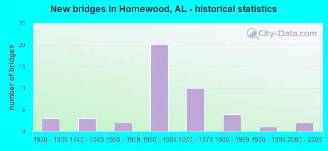
- New bridges - historical statistics
- 31930-1939
- 31940-1949
- 21950-1959
- 201960-1969
- 101970-1979
- 41980-1989
- 11990-1999
- 22000-2009
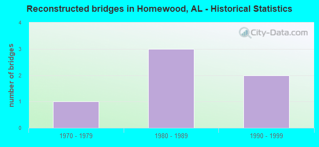
- Reconstructed bridges - Historical Statistics
- 11970-1979
- 31980-1989
- 21990-1999
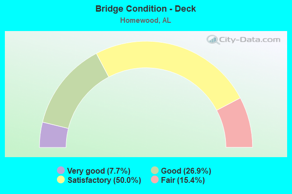
- Bridge Condition - Deck
- 7.7%Very good
- 26.9%Good
- 50.0%Satisfactory
- 15.4%Fair
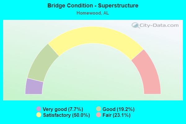
- Bridge Condition - Superstructure
- 7.7%Very good
- 19.2%Good
- 50.0%Satisfactory
- 23.1%Fair
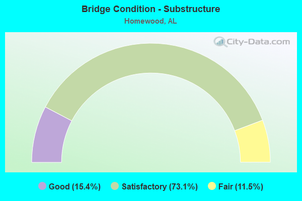
- Bridge Condition - Substructure
- 15.4%Good
- 73.1%Satisfactory
- 11.5%Fair
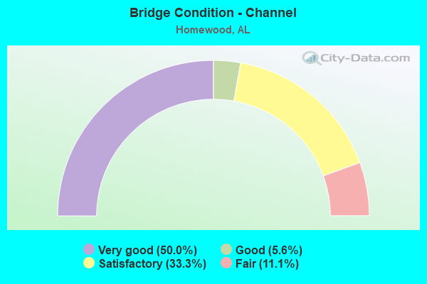
- Bridge Condition - Channel
- 50.0%Very good
- 5.6%Good
- 33.3%Satisfactory
- 11.1%Fair
Find on map >> Show street view
Structure Number: 871, Location: 1000' W COLUMBIANA RD (Lat: 33.449400, Lng: -86.812950), Route carried "on" structure: County highway 558, Year Built: 1930, Status: Open, Structure Length: 5.30m (17.39ft), Average Daily Traffic: 475 (year 2021), Truck Traffic: 2%, Average Future Daily Traffic: 665 (year 2041), Design Load: H 15, Features Intersected: SHADES CREEK, Facility Carried by Structure: OLD COLUMBIANA RD
Minimum Vertical Clearance: 30+ m (98+ ft), Kilometerpoint: 0.010, Lanes on structure: 2, Owner: County Highway Agency, Approaching Roadway Width: 5.8m (19.0ft), Material/Design: Concrete, Design/Construction: Tee Beam, Number Of Spans In Main Unit: 6, Length of Maximum Span: 7.9m (25.9ft), Curb or Sidewalk Widths: Left: 0.1m (0.3ft), Right: 0.1m (0.3ft), Curb-To-Curb Width: 6.1m (20.0ft), Out-to-Out Width: 6.8m (22.3ft)
Condition: Deck: Fair, Superstructure: Fair, Substructure: Fair, Channel: Fair, Operating Rating: 50.6 metric tons, Method Used To Determine Operating Rating: Load Factor (LF), Inventory Rating: 30.3 metric tons, Method Used To Determine Inventory Rating: Load Factor (LF), Structural Evaluation: Somewhat better than minimum adequacy, Deck Geometry: High priority of corrective action, Waterway Adequacy: Equal to present minimum criteria, Approach Roadway Alignment: Somewhat better than minimum adequacy, Length Of Structure Improvement: 6.33m (20.77ft), Designated Inspection Frequency: Every 24 months, Inspection Date: May 2021, Bridge Improvement Cost: $955,000, Roadway Improvement Cost: $96,000, Total Project Cost: $1,051,000 ( Estimate for 2022), Deck Structure Type: Concrete Cast-file-Place, Wearing Surface/Protective System: Wearing Surface: Bituminous
Find on map >> Show street view
Structure Number: 2647, Location: .1 MI. SO. AL 149 (Lat: 33.466389, Lng: -86.777500), Route carried "on" structure: US 31, Year Built: 1942, Status: Open, Structure Length: 9.69m (31.79ft), Average Daily Traffic: 30,220 (year 2021), Truck Traffic: 5%, Average Future Daily Traffic: 38,820 (year 2041), Design Load: H 20, Features Intersected: SHADES CK
Minimum Vertical Clearance: 30+ m (98+ ft), Kilometerpoint: 435.376, Lanes on structure: 4, Base Highway Network: Yes, Owner: State Highway Agency, Approaching Roadway Width: 22.6m (74.1ft), Skew: 20 degrees, Material/Design: Concrete, Design/Construction: Tee Beam, Number Of Spans In Main Unit: 6, Length of Maximum Span: 15.8m (51.8ft), Curb or Sidewalk Widths: Left: 1.2m (3.9ft), Right: 1.2m (3.9ft), Curb-To-Curb Width: 15.4m (50.5ft), Out-to-Out Width: 17.7m (58.1ft)
Condition: Deck: Fair, Superstructure: Fair, Substructure: Fair, Channel: Satisfactory, Operating Rating: 47.9 metric tons, Method Used To Determine Operating Rating: Load Factor (LF), Inventory Rating: 28.8 metric tons, Method Used To Determine Inventory Rating: Load Factor (LF), Structural Evaluation: Somewhat better than minimum adequacy, Deck Geometry: Meets minimum limits, Waterway Adequacy: Superior to present desirable criteria, Approach Roadway Alignment: Somewhat better than minimum adequacy, Length Of Structure Improvement: 10.63m (34.88ft), Designated Inspection Frequency: Every 24 months, Inspection Date: May 2021, Bridge Improvement Cost: $4,228,000, Roadway Improvement Cost: $423,000, Total Project Cost: $4,651,000 ( Estimate for 2022), Deck Structure Type: Concrete Cast-file-Place, Wearing Surface/Protective System: Wearing Surface: Bituminous
Find on map >> Show street view
Structure Number: 2648, Location: AL 149 INTERCHANGE (Lat: 33.467778, Lng: -86.777500), Route carried "on" structure: US 31, Year Built: 1942, Status: Open, Structure Length: 4.24m (13.91ft), Average Daily Traffic: 30,220 (year 2020), Truck Traffic: 5%, Average Future Daily Traffic: 38,820 (year 2040), Design Load: H 20, Features Intersected: AL 149
Minimum Vertical Clearance: 30+ m (98+ ft), Kilometerpoint: 435.488, Lanes on structure: 4, Lanes under structure: 4, Base Highway Network: Yes, Owner: State Highway Agency, Approaching Roadway Width: 22.9m (75.1ft), Skew: 20 degrees, Material/Design: Concrete, Design/Construction: Arch - Deck, Number Of Spans In Main Unit: 1, Length of Maximum Span: 21.3m (69.9ft), Curb or Sidewalk Widths: Left: 1.3m (4.3ft), Right: 1.3m (4.3ft), Curb-To-Curb Width: 15.3m (50.2ft), Out-to-Out Width: 17.7m (58.1ft)
Condition: Deck: Fair, Superstructure: Fair, Substructure: Satisfactory, Operating Rating: 59.3 metric tons, Method Used To Determine Operating Rating: Load Factor (LF), Inventory Rating: 35.6 metric tons, Method Used To Determine Inventory Rating: Load Factor (LF), Structural Evaluation: Somewhat better than minimum adequacy, Deck Geometry: High priority of corrective action, Underclear: High priority of corrective action, Approach Roadway Alignment: Better than present minimum criteria, Length Of Structure Improvement: 5.21m (17.09ft), Designated Inspection Frequency: Every 24 months, Inspection Date: September 2020, Bridge Improvement Cost: $2,072,000, Roadway Improvement Cost: $207,000, Total Project Cost: $2,279,000 ( Estimate for 2022), Deck Structure Type: Concrete Cast-file-Place, Wearing Surface/Protective System: Wearing Surface: Bituminous
Find on map >> Show street view
Structure Number: 6426, Location: 1500' S LAKESHORE DR (Lat: 33.450347, Lng: -86.811053), Route carried "on" structure: County highway 501, Year Built: 1958, Status: Open, Structure Length: 4.96m (16.27ft), Average Daily Traffic: 14,680 (year 2021), Truck Traffic: 20%, Average Future Daily Traffic: 20,525 (year 2041), Design Load: H 20, Features Intersected: SHADES CREEK, Facility Carried by Structure: SB COLUMBIANA RD
Minimum Vertical Clearance: 30+ m (98+ ft), Kilometerpoint: 0.010, Lanes on structure: 2, Owner: County Highway Agency, Approaching Roadway Width: 9.8m (32.2ft), Material/Design: Concrete, Design/Construction: Tee Beam, Number Of Spans In Main Unit: 4, Length of Maximum Span: 11.3m (37.1ft), Curb-To-Curb Width: 8.5m (27.9ft), Out-to-Out Width: 9.8m (32.2ft)
Condition: Deck: Satisfactory, Superstructure: Satisfactory, Substructure: Satisfactory, Channel: Satisfactory, Operating Rating: 54.2 metric tons, Method Used To Determine Operating Rating: Load Factor (LF), Inventory Rating: 32.5 metric tons, Method Used To Determine Inventory Rating: Load Factor (LF), Structural Evaluation: Equal to present minimum criteria, Deck Geometry: High priority of corrective action, Waterway Adequacy: Equal to present minimum criteria, Approach Roadway Alignment: Better than present minimum criteria, Length Of Structure Improvement: 5.98m (19.62ft), Designated Inspection Frequency: Every 24 months, Inspection Date: June 2021, Bridge Improvement Cost: $1,312,000, Roadway Improvement Cost: $131,000, Total Project Cost: $1,443,000 ( Estimate for 2022), Deck Structure Type: Concrete Cast-file-Place
Find on map >> Show street view
Structure Number: 7079, Location: INT SAULTER * BROADWAY (Lat: 33.466667, Lng: -86.800000), Route carried "on" structure: City street , Year Built: 1960, Status: Open, Structure Length: 1.16m (3.81ft), Average Daily Traffic: 5,055 (year 2020), Truck Traffic: 1%, Average Future Daily Traffic: 9,977 (year 2040), Design Load: H 15, Features Intersected: GRIFFIN BROOK, Facility Carried by Structure: SAULTER RD
Minimum Vertical Clearance: 30+ m (98+ ft), Kilometerpoint: 0.800, Lanes on structure: 2, Owner: City or Municipal Highway Agency, Approaching Roadway Width: 8.2m (26.9ft), Skew: 2 degrees, Material/Design: Concrete, Design/Construction: Tee Beam, Number Of Spans In Main Unit: 1, Length of Maximum Span: 11.6m (38.1ft), Curb-To-Curb Width: 8.1m (26.6ft), Out-to-Out Width: 8.3m (27.2ft)
Condition: Deck: Fair, Superstructure: Fair, Substructure: Satisfactory, Channel: Very good, Operating Rating: 43.5 metric tons, Method Used To Determine Operating Rating: Field evaluation and documented engineering judgment, Inventory Rating: 32.7 metric tons, Method Used To Determine Inventory Rating: Field evaluation and documented engineering judgment, Structural Evaluation: Somewhat better than minimum adequacy, Deck Geometry: High priority of replacement, Waterway Adequacy: Somewhat better than minimum adequacy, Approach Roadway Alignment: Better than present minimum criteria, Length Of Structure Improvement: 1.83m (6.00ft), Designated Inspection Frequency: Every 24 months, Inspection Date: September 2020, Bridge Improvement Cost: $339,000, Roadway Improvement Cost: $34,000, Total Project Cost: $373,000 ( Estimate for 2022), Deck Structure Type: Concrete Precast Panels, Wearing Surface/Protective System: Wearing Surface: Bituminous
Find on map >> Show street view
Structure Number: 8323, Location: US 280 * LANE PK RAMP (Lat: 33.483333, Lng: -86.780000), Route carried "on" structure: Ramp US 280, Year Built: 1964, Status: Open, Structure Length: 6.46m (21.19ft), Average Daily Traffic: 6,655 (year 2021), Truck Traffic: 6%, Average Future Daily Traffic: 8,753 (year 2041), Design Load: HS 20, Features Intersected: LANE PARK RAMP, Facility Carried by Structure: AL - 38 WEST
Minimum Vertical Clearance: 30+ m (98+ ft), Kilometerpoint: 0.563, Lanes on structure: 3, Lanes under structure: 2, Base Highway Network: Yes, Owner: State Highway Agency, Approaching Roadway Width: 12.2m (40.0ft), Skew: 4 degrees, Material/Design: Steel, Design/Construction: Stringer/Multi-beam, Number Of Spans In Main Unit: 3, Length of Maximum Span: 24.4m (80.1ft), Curb-To-Curb Width: 14.6m (47.9ft), Out-to-Out Width: 15.5m (50.9ft)
Condition: Deck: Satisfactory, Superstructure: Fair, Substructure: Satisfactory, Operating Rating: 57.0 metric tons, Method Used To Determine Operating Rating: Load Factor (LF), Inventory Rating: 34.1 metric tons, Method Used To Determine Inventory Rating: Load Factor (LF), Structural Evaluation: Somewhat better than minimum adequacy, Deck Geometry: Better than present minimum criteria, Underclear: Meets minimum limits, Approach Roadway Alignment: Equal to present desirable criteria, Length Of Structure Improvement: 7.50m (24.61ft), Designated Inspection Frequency: Every 24 months, Inspection Date: July 2021, Bridge Improvement Cost: $2,623,000, Roadway Improvement Cost: $262,000, Total Project Cost: $2,885,000 ( Estimate for 2022), Deck Structure Type: Concrete Cast-file-Place
Find on map >> Show street view
Structure Number: 8325, Location: US 280 * HOLLYWOOD BLVD (Lat: 33.482400, Lng: -86.777800), Route carried "on" structure: County highway , Year Built: 1964, Status: Open, Structure Length: 7.01m (23.00ft), Average Daily Traffic: 1,800 (year 2020), Truck Traffic: 1%, Average Future Daily Traffic: 2,024 (year 2040), Design Load: HS 20, Features Intersected: AL - 38 (US 280), Facility Carried by Structure: HOLLYWOOD BLVD
Minimum Vertical Clearance: 30+ m (98+ ft), Kilometerpoint: 0.010, Lanes on structure: 2, Lanes under structure: 5, Owner: State Highway Agency, Approaching Roadway Width: 8.5m (27.9ft), Skew: 2 degrees, Material/Design: Steel, Design/Construction: Stringer/Multi-beam, Number Of Spans In Main Unit: 4, Length of Maximum Span: 18.3m (60.0ft), Curb-To-Curb Width: 8.5m (27.9ft), Out-to-Out Width: 9.9m (32.5ft)
Condition: Deck: Satisfactory, Superstructure: Satisfactory, Substructure: Satisfactory, Operating Rating: 77.2 metric tons, Method Used To Determine Operating Rating: Load Factor (LF), Inventory Rating: 46.2 metric tons, Method Used To Determine Inventory Rating: Load Factor (LF), Structural Evaluation: Equal to present minimum criteria, Deck Geometry: Somewhat better than minimum adequacy, Underclear: Meets minimum limits, Approach Roadway Alignment: Better than present minimum criteria, Length Of Structure Improvement: 8.04m (26.38ft), Designated Inspection Frequency: Every 24 months, Inspection Date: May 2020, Bridge Improvement Cost: $1,765,000, Roadway Improvement Cost: $177,000, Total Project Cost: $1,942,000 ( Estimate for 2022), Deck Structure Type: Concrete Cast-file-Place
Find on map >> Show street view
Structure Number: 8326, Location: US 280 * AL 149 (Lat: 33.474167, Lng: -86.767222), Route carried "on" structure: US 280, Year Built: 1964, Year Reconstructed: 1998, Status: Open, Structure Length: 7.68m (25.20ft), Average Daily Traffic: 33,735 (year 2021), Truck Traffic: 6%, Average Future Daily Traffic: 44,374 (year 2041), Design Load: HS 20, Features Intersected: AL 149
Minimum Vertical Clearance: 30+ m (98+ ft), Kilometerpoint: 2.124, Lanes on structure: 4, Lanes under structure: 4, Base Highway Network: Yes, Owner: State Highway Agency, Approaching Roadway Width: 13.1m (43.0ft), Skew: 3 degrees, Material/Design: Steel, Design/Construction: Stringer/Multi-beam, Number Of Spans In Main Unit: 4, Length of Maximum Span: 19.2m (63.0ft), Curb-To-Curb Width: 11.0m (36.1ft), Out-to-Out Width: 18.7m (61.4ft)
Condition: Deck: Satisfactory, Superstructure: Satisfactory, Substructure: Satisfactory, Operating Rating: 88.9 metric tons, Method Used To Determine Operating Rating: Load Factor (LF), Inventory Rating: 65.0 metric tons, Method Used To Determine Inventory Rating: Load Factor (LF), Structural Evaluation: Equal to present minimum criteria, Deck Geometry: High priority of replacement, Underclear: High priority of corrective action, Approach Roadway Alignment: Equal to present desirable criteria, Length Of Structure Improvement: 8.70m (28.54ft), Designated Inspection Frequency: Every 24 months, Inspection Date: June 2021, Bridge Improvement Cost: $3,638,000, Roadway Improvement Cost: $364,000, Total Project Cost: $4,002,000 ( Estimate for 2022), Deck Structure Type: Concrete Cast-file-Place
Find on map >> Show street view
Structure Number: 8327, Location: US 280 * AL 149 (Lat: 33.474167, Lng: -86.767222), Route carried "on" structure: US 280, Year Built: 1964, Year Reconstructed: 1998, Status: Open, Structure Length: 7.68m (25.20ft), Average Daily Traffic: 33,735 (year 2021), Truck Traffic: 6%, Average Future Daily Traffic: 44,374 (year 2041), Design Load: HS 20, Features Intersected: AL 149
Minimum Vertical Clearance: 30+ m (98+ ft), Kilometerpoint: 2.124, Lanes on structure: 3, Lanes under structure: 4, Base Highway Network: Yes, Owner: State Highway Agency, Approaching Roadway Width: 12.2m (40.0ft), Skew: 3 degrees, Material/Design: Steel, Design/Construction: Stringer/Multi-beam, Number Of Spans In Main Unit: 4, Length of Maximum Span: 19.2m (63.0ft), Curb-To-Curb Width: 12.8m (42.0ft), Out-to-Out Width: 20.9m (68.6ft)
Condition: Deck: Satisfactory, Superstructure: Satisfactory, Substructure: Satisfactory, Operating Rating: 71.6 metric tons, Method Used To Determine Operating Rating: Load Factor (LF), Inventory Rating: 42.8 metric tons, Method Used To Determine Inventory Rating: Load Factor (LF), Structural Evaluation: Equal to present minimum criteria, Deck Geometry: Meets minimum limits, Underclear: Equal to present minimum criteria, Approach Roadway Alignment: Equal to present desirable criteria, Length Of Structure Improvement: 8.70m (28.54ft), Designated Inspection Frequency: Every 24 months, Inspection Date: June 2021, Bridge Improvement Cost: $4,056,000, Roadway Improvement Cost: $406,000, Total Project Cost: $4,462,000 ( Estimate for 2022), Deck Structure Type: Concrete Cast-file-Place
Find on map >> Show street view
Structure Number: 8934, Location: OXMOOR (Lat: 33.433061, Lng: -86.841558), Route carried "on" structure: County highway 503, Year Built: 1965, Status: Posted for load, Structure Length: 5.18m (16.99ft), Average Daily Traffic: 15,830 (year 2021), Truck Traffic: 10%, Average Future Daily Traffic: 22,000 (year 2041), Design Load: H 20, Features Intersected: SHADES CREEK, Facility Carried by Structure: WEST OXMOOR ROAD
Minimum Vertical Clearance: 30+ m (98+ ft), Kilometerpoint: 0.010, Lanes on structure: 2, Owner: County Highway Agency, Approaching Roadway Width: 6.9m (22.6ft), Material/Design: Concrete, Design/Construction: Channel Beam, Number Of Spans In Main Unit: 5, Length of Maximum Span: 10.4m (34.1ft), Curb or Sidewalk Widths: Left: 0.4m (1.3ft), Right: 0.4m (1.3ft), Curb-To-Curb Width: 8.2m (26.9ft), Out-to-Out Width: 9.1m (29.9ft)
Condition: Deck: Satisfactory, Superstructure: Satisfactory, Substructure: Satisfactory, Channel: Satisfactory, Operating Rating: 37.6 metric tons, Method Used To Determine Operating Rating: Load Factor (LF), Inventory Rating: 21.5 metric tons, Method Used To Determine Inventory Rating: Load Factor (LF), Structural Evaluation: Somewhat better than minimum adequacy, Deck Geometry: High priority of replacement, Waterway Adequacy: Better than present minimum criteria, Approach Roadway Alignment: Better than present minimum criteria, Bridge Posting: Required (Relationship of Operating Rating to Maximum Legal Load: 0.1 - 9.9% below), Length Of Structure Improvement: 6.21m (20.37ft), Designated Inspection Frequency: Every 24 months, Other Special Inspection Frequency: Every 12 months, Inspection Date: August 2021, Other Special Inspection Date: August 2021, Bridge Improvement Cost: $1,234,000, Roadway Improvement Cost: $123,000, Total Project Cost: $1,357,000 ( Estimate for 2022), Deck Structure Type: Concrete Precast Panels, Wearing Surface/Protective System: Wearing Surface: Bituminous
Find on map >> Show street view
Structure Number: 9966, Location: US 31 * US 280 INTERCHANG (Lat: 33.484722, Lng: -86.786667), Route carried "on" structure: US 31, Year Built: 1969, Status: Open, Structure Length: 7.50m (24.61ft), Average Daily Traffic: 16,400 (year 2021), Truck Traffic: 5%, Average Future Daily Traffic: 21,067 (year 2041), Design Load: HS 20, Features Intersected: ROSEDALE DRIVE, Facility Carried by Structure: AL - 3 SOUTH
Minimum Vertical Clearance: 5.41m (17.75ft), Kilometerpoint: 437.822, Lanes on structure: 2, Lanes under structure: 4, Owner: State Highway Agency, Approaching Roadway Width: 13.4m (44.0ft), Material/Design: Steel, Design/Construction: Stringer/Multi-beam, Number Of Spans In Main Unit: 4, Length of Maximum Span: 21.6m (70.9ft), Curb-To-Curb Width: 11.2m (36.7ft), Out-to-Out Width: 11.6m (38.1ft)
Condition: Deck: Satisfactory, Superstructure: Satisfactory, Substructure: Fair, Operating Rating: 81.9 metric tons, Method Used To Determine Operating Rating: Load Factor (LF), Inventory Rating: 49.1 metric tons, Method Used To Determine Inventory Rating: Load Factor (LF), Structural Evaluation: Somewhat better than minimum adequacy, Deck Geometry: Equal to present minimum criteria, Underclear: High priority of corrective action, Approach Roadway Alignment: Equal to present desirable criteria, Length Of Structure Improvement: 8.52m (27.95ft), Designated Inspection Frequency: Every 24 months, Inspection Date: April 2021, Bridge Improvement Cost: $2,221,000, Roadway Improvement Cost: $222,000, Total Project Cost: $2,443,000 ( Estimate for 2022), Deck Structure Type: Concrete Cast-file-Place
Find on map >> Show street view
Structure Number: 9967, Location: US 31 * US 280 INTR (Lat: 33.483333, Lng: -86.786667), Route carried "on" structure: US 31, Year Built: 1969, Status: Open, Structure Length: 7.50m (24.61ft), Average Daily Traffic: 16,400 (year 2021), Truck Traffic: 5%, Average Future Daily Traffic: 21,067 (year 2041), Design Load: HS 20, Features Intersected: RAMP A * US 280, Facility Carried by Structure: AL - 3 NORTH
Minimum Vertical Clearance: 4.93m (16.17ft), Kilometerpoint: 437.822, Lanes on structure: 2, Lanes under structure: 4, Owner: State Highway Agency, Approaching Roadway Width: 13.4m (44.0ft), Material/Design: Steel, Design/Construction: Stringer/Multi-beam, Number Of Spans In Main Unit: 4, Length of Maximum Span: 21.6m (70.9ft), Curb-To-Curb Width: 12.6m (41.3ft), Out-to-Out Width: 13.1m (43.0ft)
Condition: Deck: Satisfactory, Superstructure: Satisfactory, Substructure: Satisfactory, Operating Rating: 86.2 metric tons, Method Used To Determine Operating Rating: Load Factor (LF), Inventory Rating: 51.6 metric tons, Method Used To Determine Inventory Rating: Load Factor (LF), Structural Evaluation: Equal to present minimum criteria, Deck Geometry: Better than present minimum criteria, Underclear: Meets minimum limits, Approach Roadway Alignment: Equal to present desirable criteria, Length Of Structure Improvement: 8.52m (27.95ft), Designated Inspection Frequency: Every 24 months, Inspection Date: March 2021, Bridge Improvement Cost: $2,513,000, Roadway Improvement Cost: $251,000, Total Project Cost: $2,764,000 ( Estimate for 2022), Deck Structure Type: Concrete Cast-file-Place, Wearing Surface/Protective System: Wearing Surface: Bituminous
Find on map >> Show street view
Structure Number: 9968, Location: US 31 * US 280 INTR (Lat: 33.483333, Lng: -86.786667), Route carried "on" structure: Ramp US 31, Year Built: 1969, Status: Open, Structure Length: 26.82m (87.99ft), Average Daily Traffic: 7,976 (year 2021), Truck Traffic: 3%, Average Future Daily Traffic: 10,245 (year 2041), Design Load: HS 20, Features Intersected: US 31 * US 280, Facility Carried by Structure: AL - 3 SO RAMP
Minimum Vertical Clearance: 30+ m (98+ ft), Kilometerpoint: 437.903, Lanes on structure: 2, Lanes under structure: 8, Owner: State Highway Agency, Approaching Roadway Width: 11.9m (39.0ft), Material/Design: Steel continuous, Design/Construction: Stringer/Multi-beam, Number Of Spans In Main Unit: 2, Number Of Approach Spans: 10, Length of Maximum Span: 30.8m (101.0ft), Curb-To-Curb Width: 12.0m (39.4ft), Out-to-Out Width: 12.4m (40.7ft)
Condition: Deck: Satisfactory, Superstructure: Satisfactory, Substructure: Satisfactory, Operating Rating: 45.7 metric tons, Method Used To Determine Operating Rating: Load Factor (LF), Inventory Rating: 27.4 metric tons, Method Used To Determine Inventory Rating: Load Factor (LF), Structural Evaluation: Equal to present minimum criteria, Deck Geometry: Superior to present desirable criteria, Underclear: High priority of corrective action, Approach Roadway Alignment: Somewhat better than minimum adequacy, Length Of Structure Improvement: 26.82m (87.99ft), Designated Inspection Frequency: Every 24 months, Inspection Date: April 2021, Bridge Improvement Cost: $7,356,000, Roadway Improvement Cost: $736,000, Total Project Cost: $8,092,000 ( Estimate for 2022), Deck Structure Type: Concrete Cast-file-Place
Find on map >> Show street view
Structure Number: 10185, Location: I 65 * WEST VALLEY AVE (Lat: 33.469500, Lng: -86.828300), Route carried "on" structure: City street , Year Built: 1970, Status: Open, Structure Length: 8.69m (28.51ft), Average Daily Traffic: 12,500 (year 2020), Truck Traffic: 2%, Average Future Daily Traffic: 18,000 (year 2040), Design Load: HS 20, Features Intersected: I - 65, Facility Carried by Structure: WEST VALLEY AVE
Minimum Vertical Clearance: 30+ m (98+ ft), Kilometerpoint: 0.010, Lanes on structure: 4, Lanes under structure: 6, Owner: State Highway Agency, Approaching Roadway Width: 13.4m (44.0ft), Material/Design: Steel continuous, Design/Construction: Stringer/Multi-beam, Number Of Spans In Main Unit: 4, Length of Maximum Span: 24.4m (80.1ft), Curb-To-Curb Width: 13.4m (44.0ft), Out-to-Out Width: 13.9m (45.6ft)
Condition: Deck: Satisfactory, Superstructure: Satisfactory, Substructure: Satisfactory, Operating Rating: 59.4 metric tons, Method Used To Determine Operating Rating: Load Factor (LF), Inventory Rating: 35.6 metric tons, Method Used To Determine Inventory Rating: Load Factor (LF), Structural Evaluation: Equal to present minimum criteria, Deck Geometry: High priority of replacement, Underclear: Equal to present minimum criteria, Approach Roadway Alignment: Equal to present desirable criteria, Length Of Structure Improvement: 9.67m (31.73ft), Designated Inspection Frequency: Every 24 months, Inspection Date: June 2020, Bridge Improvement Cost: $2,984,000, Roadway Improvement Cost: $298,000, Total Project Cost: $3,282,000 ( Estimate for 2022), Deck Structure Type: Concrete Cast-file-Place
Find on map >> Show street view
Structure Number: 13569, Location: US 31 * BROOKWOOD HOSP (Lat: 33.463014, Lng: -86.779392), Route carried "on" structure: Business City street , Year Built: 1985, Status: Open, Structure Length: 5.97m (19.59ft), Average Daily Traffic: 3,800 (year 2020), Truck Traffic: 1%, Average Future Daily Traffic: 5,100 (year 2040), Design Load: HS 20, Features Intersected: AL - 3 (US 31), Facility Carried by Structure: MEDICAL CENTER DR
Minimum Vertical Clearance: 30+ m (98+ ft), Kilometerpoint: 0.010, Lanes on structure: 3, Lanes under structure: 4, Owner: State Highway Agency, Approaching Roadway Width: 14.6m (47.9ft), Material/Design: Prestressed concrete, Design/Construction: Stringer/Multi-beam, Number Of Spans In Main Unit: 1, Number Of Approach Spans: 2, Length of Maximum Span: 29.3m (96.1ft), Curb-To-Curb Width: 14.6m (47.9ft), Out-to-Out Width: 15.5m (50.9ft)
Condition: Deck: Good, Superstructure: Satisfactory, Substructure: Satisfactory, Operating Rating: 60.1 metric tons, Method Used To Determine Operating Rating: Load Factor (LF), Inventory Rating: 35.9 metric tons, Method Used To Determine Inventory Rating: Load Factor (LF), Structural Evaluation: Equal to present minimum criteria, Deck Geometry: Somewhat better than minimum adequacy, Underclear: Equal to present minimum criteria, Approach Roadway Alignment: Equal to present desirable criteria, Length Of Structure Improvement: 7.01m (23.00ft), Designated Inspection Frequency: Every 24 months, Inspection Date: October 2020, Bridge Improvement Cost: $2,453,000, Roadway Improvement Cost: $245,000, Total Project Cost: $2,698,000 ( Estimate for 2022), Deck Structure Type: Concrete Cast-file-Place
Find on map >> Show street view
Structure Number: 14425, Location: I 65 * SHADE CREEK (Lat: 33.445894, Lng: -86.818261), Route carried "on" structure: Interstate 65, Year Built: 1972, Year Reconstructed: 1988, Status: Open, Structure Length: 17.37m (56.99ft), Average Daily Traffic: 60,340 (year 2020), Truck Traffic: 10%, Average Future Daily Traffic: 76,446 (year 2040), Design Load: HS 20, Features Intersected: SHADES CREEK
Minimum Vertical Clearance: 30+ m (98+ ft), Kilometerpoint: 410.119, Lanes on structure: 4, Base Highway Network: Yes, Owner: State Highway Agency, Approaching Roadway Width: 20.7m (67.9ft), Skew: 3 degrees, Material/Design: Steel, Design/Construction: Stringer/Multi-beam, Number Of Spans In Main Unit: 8, Length of Maximum Span: 24.4m (80.1ft), Curb-To-Curb Width: 20.7m (67.9ft), Out-to-Out Width: 22.4m (73.5ft)
Condition: Deck: Satisfactory, Superstructure: Satisfactory, Substructure: Satisfactory, Channel: Satisfactory, Operating Rating: 48.7 metric tons, Method Used To Determine Operating Rating: Load Factor (LF), Inventory Rating: 29.2 metric tons, Method Used To Determine Inventory Rating: Load Factor (LF), Structural Evaluation: Equal to present minimum criteria, Deck Geometry: Equal to present minimum criteria, Waterway Adequacy: Equal to present desirable criteria, Approach Roadway Alignment: Better than present minimum criteria, Length Of Structure Improvement: 18.08m (59.32ft), Designated Inspection Frequency: Every 24 months, Inspection Date: October 2020, Bridge Improvement Cost: $9,051,000, Roadway Improvement Cost: $905,000, Total Project Cost: $9,956,000 ( Estimate for 2022), Deck Structure Type: Concrete Cast-file-Place
Find on map >> Show street view
Structure Number: 14426, Location: I 65 * SHADE CREEK (Lat: 33.445911, Lng: -86.817967), Route carried "on" structure: Interstate 65, Year Built: 1972, Year Reconstructed: 1988, Status: Open, Structure Length: 17.37m (56.99ft), Average Daily Traffic: 60,340 (year 2020), Truck Traffic: 10%, Average Future Daily Traffic: 76,446 (year 2040), Design Load: HS 20, Features Intersected: SHADES CREEK
Minimum Vertical Clearance: 30+ m (98+ ft), Kilometerpoint: 410.119, Lanes on structure: 3, Base Highway Network: Yes, Owner: State Highway Agency, Approaching Roadway Width: 24.4m (80.1ft), Skew: 3 degrees, Material/Design: Steel, Design/Construction: Stringer/Multi-beam, Number Of Spans In Main Unit: 8, Length of Maximum Span: 24.4m (80.1ft), Curb-To-Curb Width: 24.4m (80.1ft), Out-to-Out Width: 26.1m (85.6ft)
Condition: Deck: Good, Superstructure: Satisfactory, Substructure: Satisfactory, Channel: Satisfactory, Operating Rating: 51.3 metric tons, Method Used To Determine Operating Rating: Load Factor (LF), Inventory Rating: 30.8 metric tons, Method Used To Determine Inventory Rating: Load Factor (LF), Structural Evaluation: Equal to present minimum criteria, Deck Geometry: Superior to present desirable criteria, Waterway Adequacy: Equal to present desirable criteria, Approach Roadway Alignment: Equal to present desirable criteria, Length Of Structure Improvement: 18.08m (59.32ft), Designated Inspection Frequency: Every 24 months, Inspection Date: September 2020, Bridge Improvement Cost: $10,539,000, Roadway Improvement Cost: $1,054,000, Total Project Cost: $11,593,000 ( Estimate for 2022), Deck Structure Type: Concrete Cast-file-Place
Find on map >> Show street view
Structure Number: 14427, Location: I65*RALEIGH AVE. (Lat: 33.458442, Lng: -86.820475), Route carried "on" structure: Interstate 65, Year Built: 1972, Year Reconstructed: 1988, Status: Open, Structure Length: 6.77m (22.21ft), Average Daily Traffic: 123,190 (year 2020), Truck Traffic: 10%, Average Future Daily Traffic: 156,073 (year 2040), Design Load: HS 20, Features Intersected: RALEIGH AVE.
Minimum Vertical Clearance: 30+ m (98+ ft), Kilometerpoint: 411.550, Lanes on structure: 6, Lanes under structure: 2, Base Highway Network: Yes, Owner: State Highway Agency, Approaching Roadway Width: 30.5m (100.1ft), Skew: 30 degrees, Material/Design: Steel continuous, Design/Construction: Stringer/Multi-beam, Number Of Spans In Main Unit: 3, Length of Maximum Span: 26.2m (86.0ft), Curb-To-Curb Width: 30.3m (99.4ft), Out-to-Out Width: 33.3m (109.3ft)
Condition: Deck: Satisfactory, Superstructure: Fair, Substructure: Satisfactory, Operating Rating: 52.3 metric tons, Method Used To Determine Operating Rating: Load Factor (LF), Inventory Rating: 31.4 metric tons, Method Used To Determine Inventory Rating: Load Factor (LF), Structural Evaluation: Somewhat better than minimum adequacy, Deck Geometry: Superior to present desirable criteria, Underclear: Superior to present desirable criteria, Approach Roadway Alignment: Equal to present desirable criteria, Length Of Structure Improvement: 7.81m (25.62ft), Designated Inspection Frequency: Every 24 months, Inspection Date: April 2020, Bridge Improvement Cost: $5,834,000, Roadway Improvement Cost: $583,000, Total Project Cost: $6,417,000 ( Estimate for 2022), Deck Structure Type: Concrete Cast-file-Place
Find on map >> Show street view
Structure Number: 14784, Location: LAKE SHORE DR * I 65 (Lat: 33.449900, Lng: -86.818400), Route carried "on" structure: City street , Year Built: 1989, Status: Open, Structure Length: 8.84m (29.00ft), Average Daily Traffic: 11,000 (year 2020), Truck Traffic: 2%, Average Future Daily Traffic: 18,000 (year 2040), Design Load: HS 20, Features Intersected: I - 65, Facility Carried by Structure: LAKE SHORE DRIVE
Minimum Vertical Clearance: 7.56m (24.80ft), Kilometerpoint: 0.010, Lanes on structure: 6, Lanes under structure: 7, Owner: State Highway Agency, Approaching Roadway Width: 26.5m (86.9ft), Material/Design: Prestressed concrete, Design/Construction: Stringer/Multi-beam, Number Of Spans In Main Unit: 2, Number Of Approach Spans: 1, Length of Maximum Span: 27.4m (89.9ft), Curb-To-Curb Width: 25.6m (84.0ft), Out-to-Out Width: 26.5m (86.9ft)
Condition: Deck: Satisfactory, Superstructure: Satisfactory, Substructure: Satisfactory, Operating Rating: 51.6 metric tons, Method Used To Determine Operating Rating: Load Factor (LF), Inventory Rating: 28.8 metric tons, Method Used To Determine Inventory Rating: Load Factor (LF), Structural Evaluation: Equal to present minimum criteria, Deck Geometry: Somewhat better than minimum adequacy, Underclear: Meets minimum limits, Approach Roadway Alignment: Equal to present desirable criteria, Length Of Structure Improvement: 9.82m (32.22ft), Designated Inspection Frequency: Every 24 months, Inspection Date: May 2020, Bridge Improvement Cost: $5,789,000, Roadway Improvement Cost: $579,000, Total Project Cost: $6,368,000 ( Estimate for 2022), Deck Structure Type: Concrete Cast-file-Place
Find on map >> Show street view
Structure Number: 15846, Location: 0.2 MI S OXMOOR RD (Lat: 33.472925, Lng: -86.799875), Route carried "on" structure: City street 14, Year Built: 1952, Status: Open, Structure Length: 0.73m (2.40ft), Average Daily Traffic: 636 (year 2020), Truck Traffic: 1%, Average Future Daily Traffic: 976 (year 2040), Design Load: H 20, Features Intersected: GRIFFIN CRK., Facility Carried by Structure: WEST GLENNWOOD DR
Minimum Vertical Clearance: 30+ m (98+ ft), Kilometerpoint: 0.000, Lanes on structure: 2, Owner: City or Municipal Highway Agency, Approaching Roadway Width: 7.0m (23.0ft), Material/Design: Concrete, Design/Construction: Channel Beam, Number Of Spans In Main Unit: 1, Length of Maximum Span: 7.3m (24.0ft), Curb or Sidewalk Widths: Left: 0.9m (3.0ft), Right: 0.9m (3.0ft), Curb-To-Curb Width: 7.1m (23.3ft), Out-to-Out Width: 9.4m (30.8ft)
Condition: Deck: Good, Superstructure: Good, Substructure: Satisfactory, Channel: Very good, Operating Rating: 43.5 metric tons, Method Used To Determine Operating Rating: Field evaluation and documented engineering judgment, Inventory Rating: 32.7 metric tons, Method Used To Determine Inventory Rating: Field evaluation and documented engineering judgment, Structural Evaluation: Equal to present minimum criteria, Deck Geometry: Meets minimum limits, Waterway Adequacy: Better than present minimum criteria, Approach Roadway Alignment: Better than present minimum criteria, Length Of Structure Improvement: 1.38m (4.53ft), Designated Inspection Frequency: Every 24 months, Inspection Date: September 2020, Bridge Improvement Cost: $293,000, Roadway Improvement Cost: $29,000, Total Project Cost: $322,000 ( Estimate for 2022), Deck Structure Type: Concrete Precast Panels, Wearing Surface/Protective System: Wearing Surface: Bituminous
Find on map >> Show street view
Structure Number: 15847, Location: 0.3MI. E. OXMOOR RD (Lat: 33.451667, Lng: -86.840000), Route carried "on" structure: City street , Year Built: 1976, Status: Open, Structure Length: 1.04m (3.41ft), Average Daily Traffic: 1,586 (year 2020), Truck Traffic: 1%, Average Future Daily Traffic: 2,458 (year 2040), Design Load: HS 20, Features Intersected: STREAM, Facility Carried by Structure: W.HOMEWOOD PK.RD.
Minimum Vertical Clearance: 30+ m (98+ ft), Kilometerpoint: 0.000, Lanes on structure: 2, Owner: City or Municipal Highway Agency, Approaching Roadway Width: 7.3m (24.0ft), Material/Design: Concrete, Design/Construction: Channel Beam, Number Of Spans In Main Unit: 1, Length of Maximum Span: 10.4m (34.1ft), Curb-To-Curb Width: 7.4m (24.3ft), Out-to-Out Width: 7.4m (24.3ft)
Condition: Deck: Good, Superstructure: Good, Substructure: Satisfactory, Channel: Satisfactory, Operating Rating: 42.6 metric tons, Method Used To Determine Operating Rating: Load Factor (LF), Inventory Rating: 25.5 metric tons, Method Used To Determine Inventory Rating: Load Factor (LF), Structural Evaluation: Equal to present minimum criteria, Deck Geometry: Meets minimum limits, Waterway Adequacy: Better than present minimum criteria, Approach Roadway Alignment: Equal to present minimum criteria, Length Of Structure Improvement: 1.71m (5.61ft), Designated Inspection Frequency: Every 24 months, Inspection Date: September 2020, Bridge Improvement Cost: $281,000, Roadway Improvement Cost: $28,000, Total Project Cost: $309,000 ( Estimate for 2022), Deck Structure Type: Concrete Precast Panels, Wearing Surface/Protective System: Wearing Surface: Bituminous
Find on map >> Show street view
Structure Number: 15848, Location: 0.08MI. W. W.GLENNWOOD DR (Lat: 33.471667, Lng: -86.801667), Route carried "on" structure: City street , Year Built: 1937, Status: Open, Structure Length: 0.67m (2.20ft), Average Daily Traffic: 3,521 (year 2020), Truck Traffic: 1%, Average Future Daily Traffic: 10,715 (year 2040), Design Load: H 15, Features Intersected: STREAM, Facility Carried by Structure: ROSELAND DR
Minimum Vertical Clearance: 30+ m (98+ ft), Kilometerpoint: 0.000, Lanes on structure: 2, Owner: City or Municipal Highway Agency, Approaching Roadway Width: 11.0m (36.1ft), Skew: 2 degrees, Material/Design: Concrete, Design/Construction: Slab, Number Of Spans In Main Unit: 2, Length of Maximum Span: 3.4m (11.2ft), Curb or Sidewalk Widths: Left: 2.2m (7.2ft), Right: 2.2m (7.2ft), Curb-To-Curb Width: 11.0m (36.1ft), Out-to-Out Width: 15.8m (51.8ft)
Condition: Deck: Good, Superstructure: Good, Substructure: Satisfactory, Channel: Very good, Operating Rating: 43.5 metric tons, Method Used To Determine Operating Rating: Field evaluation and documented engineering judgment, Inventory Rating: 32.7 metric tons, Method Used To Determine Inventory Rating: Field evaluation and documented engineering judgment, Structural Evaluation: Equal to present minimum criteria, Deck Geometry: Somewhat better than minimum adequacy, Waterway Adequacy: Better than present minimum criteria, Approach Roadway Alignment: Equal to present desirable criteria, Length Of Structure Improvement: 1.30m (4.27ft), Designated Inspection Frequency: Every 24 months, Inspection Date: September 2020, Bridge Improvement Cost: $464,000, Roadway Improvement Cost: $46,000, Total Project Cost: $510,000 ( Estimate for 2022), Deck Structure Type: Concrete Cast-file-Place, Wearing Surface/Protective System: Wearing Surface: Bituminous
Find on map >> Show street view
Structure Number: 15849, Location: 0.5 MI. S. HILLMOOR LN (Lat: 33.451811, Lng: -86.834258), Route carried "on" structure: City street , Year Built: 1960, Year Reconstructed: 1984, Status: Open, Structure Length: 0.67m (2.20ft), Average Daily Traffic: 545 (year 2020), Truck Traffic: 1%, Average Future Daily Traffic: 848 (year 2040), Design Load: HS 15, Features Intersected: STREAM, Facility Carried by Structure: SHERBROOK DR
Minimum Vertical Clearance: 30+ m (98+ ft), Kilometerpoint: 0.000, Lanes on structure: 2, Owner: City or Municipal Highway Agency, Approaching Roadway Width: 7.0m (23.0ft), Material/Design: Concrete, Design/Construction: Culvert, Number Of Spans In Main Unit: 2, Length of Maximum Span: 4.0m (13.1ft)
Condition: Channel: Very good, Culverts: Good, Operating Rating: 57.1 metric tons, Method Used To Determine Operating Rating: Load Factor (LF), Inventory Rating: 29.2 metric tons, Method Used To Determine Inventory Rating: Load Factor (LF), Structural Evaluation: Better than present minimum criteria, Waterway Adequacy: Better than present minimum criteria, Approach Roadway Alignment: Equal to present minimum criteria, Length Of Structure Improvement: 1.30m (4.27ft), Designated Inspection Frequency: Every 24 months, Inspection Date: September 2020, Bridge Improvement Cost: $375,000, Roadway Improvement Cost: $38,000, Total Project Cost: $413,000 ( Estimate for 2022)
Find on map >> Show street view
Structure Number: 1585, Location: .2 MI S LAKESHORE DR (Lat: 33.467181, Lng: -86.776700), Route carried "on" structure: City street , Year Built: 1969, Status: Open, Structure Length: 4.15m (13.62ft), Average Daily Traffic: 9,765 (year 2020), Truck Traffic: 1%, Average Future Daily Traffic: 16,010 (year 2040), Design Load: H 20, Features Intersected: SHADES CRK, Facility Carried by Structure: BROOKWOOD BLVD
Minimum Vertical Clearance: 30+ m (98+ ft), Kilometerpoint: 0.000, Lanes on structure: 2, Owner: City or Municipal Highway Agency, Approaching Roadway Width: 12.2m (40.0ft), Material/Design: Concrete, Design/Construction: Channel Beam, Number Of Spans In Main Unit: 4, Length of Maximum Span: 10.4m (34.1ft), Curb-To-Curb Width: 13.3m (43.6ft), Out-to-Out Width: 13.9m (45.6ft)
Condition: Deck: Good, Superstructure: Good, Substructure: Good, Channel: Good, Operating Rating: 40.4 metric tons, Method Used To Determine Operating Rating: Load Factor (LF), Inventory Rating: 24.2 metric tons, Method Used To Determine Inventory Rating: Load Factor (LF), Structural Evaluation: Somewhat better than minimum adequacy, Deck Geometry: Somewhat better than minimum adequacy, Waterway Adequacy: Better than present minimum criteria, Approach Roadway Alignment: Better than present minimum criteria, Length Of Structure Improvement: 5.11m (16.77ft), Designated Inspection Frequency: Every 24 months, Inspection Date: September 2020, Bridge Improvement Cost: $1,577,000, Roadway Improvement Cost: $158,000, Total Project Cost: $1,735,000 ( Estimate for 2022), Deck Structure Type: Concrete Precast Panels, Wearing Surface/Protective System: Wearing Surface: Bituminous
Find on map >> Show street view
Structure Number: 15851, Location: 0.3MI.E.OXMOOR RD. (Lat: 33.451186, Lng: -86.835525), Route carried "on" structure: City street , Year Built: 1970, Status: Open, Structure Length: 1.04m (3.41ft), Average Daily Traffic: 1,466 (year 2020), Truck Traffic: 1%, Average Future Daily Traffic: 2,723 (year 2040), Design Load: H 20, Features Intersected: STREAM, Facility Carried by Structure: W.HOMEWOOD PK.DR.
Minimum Vertical Clearance: 30+ m (98+ ft), Kilometerpoint: 0.000, Lanes on structure: 2, Owner: City or Municipal Highway Agency, Approaching Roadway Width: 7.3m (24.0ft), Material/Design: Concrete, Design/Construction: Channel Beam, Number Of Spans In Main Unit: 1, Length of Maximum Span: 10.4m (34.1ft), Curb or Sidewalk Widths: Left: 0.2m (0.7ft), Right: 0.2m (0.7ft), Curb-To-Curb Width: 6.8m (22.3ft), Out-to-Out Width: 7.4m (24.3ft)
Condition: Deck: Good, Superstructure: Good, Substructure: Good, Channel: Very good, Operating Rating: 46.6 metric tons, Method Used To Determine Operating Rating: Load Factor (LF), Inventory Rating: 23.5 metric tons, Method Used To Determine Inventory Rating: Load Factor (LF), Structural Evaluation: Equal to present minimum criteria, Deck Geometry: High priority of corrective action, Waterway Adequacy: Equal to present desirable criteria, Approach Roadway Alignment: Better than present minimum criteria, Length Of Structure Improvement: 1.71m (5.61ft), Designated Inspection Frequency: Every 24 months, Inspection Date: September 2020, Bridge Improvement Cost: $281,000, Roadway Improvement Cost: $28,000, Total Project Cost: $309,000 ( Estimate for 2022), Deck Structure Type: Concrete Precast Panels, Wearing Surface/Protective System: Wearing Surface: Bituminous
Find on map >> Show street view
Structure Number: 15852, Location: 0.2MI.E. OXMOOR RD (Lat: 33.446933, Lng: -86.838258), Route carried "on" structure: City street , Year Built: 1972, Status: Open, Structure Length: 0.63m (2.07ft), Average Daily Traffic: 2,282 (year 2020), Truck Traffic: 45%, Average Future Daily Traffic: 3,738 (year 2040), Design Load: H 20, Features Intersected: STREAM, Facility Carried by Structure: SNOW DR
Minimum Vertical Clearance: 30+ m (98+ ft), Kilometerpoint: 0.000, Lanes on structure: 2, Owner: City or Municipal Highway Agency, Approaching Roadway Width: 7.6m (24.9ft), Material/Design: Concrete, Design/Construction: Culvert, Number Of Spans In Main Unit: 2, Length of Maximum Span: 3.0m (9.8ft)
Condition: Channel: Fair, Culverts: Good, Operating Rating: 88.9 metric tons, Method Used To Determine Operating Rating: Load Factor (LF), Inventory Rating: 57.5 metric tons, Method Used To Determine Inventory Rating: Load Factor (LF), Structural Evaluation: Better than present minimum criteria, Waterway Adequacy: Better than present minimum criteria, Approach Roadway Alignment: Equal to present desirable criteria, Length Of Structure Improvement: 1.24m (4.07ft), Designated Inspection Frequency: Every 24 months, Inspection Date: September 2020, Bridge Improvement Cost: $359,000, Roadway Improvement Cost: $36,000, Total Project Cost: $395,000 ( Estimate for 2022)
Find on map >> Show street view
Structure Number: 17051, Location: .1 MI S CARR AVE (Lat: 33.461375, Lng: -86.815903), Route carried "on" structure: City street , Year Built: 1930, Status: Open, Structure Length: 0.76m (2.49ft), Average Daily Traffic: 7,126 (year 2020), Truck Traffic: 10%, Average Future Daily Traffic: 13,236 (year 2040), Design Load: HS 15, Features Intersected: N FORK GRIFFIN CRK, Facility Carried by Structure: OLD COLUMBIANA RD
Minimum Vertical Clearance: 30+ m (98+ ft), Kilometerpoint: 0.000, Lanes on structure: 2, Owner: City or Municipal Highway Agency, Approaching Roadway Width: 7.3m (24.0ft), Material/Design: Concrete, Design/Construction: Culvert, Number Of Spans In Main Unit: 1, Length of Maximum Span: 7.6m (24.9ft), Curb-To-Curb Width: 5.9m (19.4ft), Out-to-Out Width: 6.9m (22.6ft)
Condition: Channel: Very good, Culverts: Good, Operating Rating: 32.7 metric tons, Method Used To Determine Operating Rating: Field evaluation and documented engineering judgment, Inventory Rating: 23.6 metric tons, Method Used To Determine Inventory Rating: Field evaluation and documented engineering judgment, Structural Evaluation: Somewhat better than minimum adequacy, Deck Geometry: High priority of replacement, Waterway Adequacy: Better than present minimum criteria, Approach Roadway Alignment: Equal to present minimum criteria, Length Of Structure Improvement: 1.41m (4.63ft), Designated Inspection Frequency: Every 24 months, Inspection Date: September 2020, Bridge Improvement Cost: $180,000, Roadway Improvement Cost: $18,000, Total Project Cost: $198,000 ( Estimate for 2022), Deck Structure Type: Concrete Cast-file-Place, Wearing Surface/Protective System: Wearing Surface: Bituminous
Find on map >> Show street view
Structure Number: 18568, Location: HOMEWEOOD PARK (Lat: 33.475078, Lng: -86.798939), Route carried "on" structure: City street , Year Built: 1998, Status: Open, Structure Length: 0.61m (2.00ft), Average Daily Traffic: 9,600 (year 2020), Truck Traffic: 1%, Average Future Daily Traffic: 16,717 (year 2040), Design Load: HS 20, Features Intersected: GRIFFIN BROOK, Facility Carried by Structure: OXMOOR ROAD
Minimum Vertical Clearance: 30+ m (98+ ft), Kilometerpoint: 0.000, Lanes on structure: 2, Owner: City or Municipal Highway Agency, Approaching Roadway Width: 11.0m (36.1ft), Skew: 1 degrees, Material/Design: Concrete, Design/Construction: Culvert, Number Of Spans In Main Unit: 1, Length of Maximum Span: 6.1m (20.0ft), Curb or Sidewalk Widths: Left: 1.2m (3.9ft), Right: 1.2m (3.9ft)
Condition: Channel: Very good, Culverts: Good, Operating Rating: 47.9 metric tons, Method Used To Determine Operating Rating: Load Factor (LF), Inventory Rating: 29.9 metric tons, Method Used To Determine Inventory Rating: Load Factor (LF), Structural Evaluation: Better than present minimum criteria, Waterway Adequacy: Equal to present desirable criteria, Approach Roadway Alignment: Equal to present desirable criteria, Length Of Structure Improvement: 1.22m (4.00ft), Designated Inspection Frequency: Every 24 months, Inspection Date: September 2020, Bridge Improvement Cost: $1,577,000, Roadway Improvement Cost: $158,000, Total Project Cost: $1,735,000 ( Estimate for 2022)
Find on map >> Show street view
Structure Number: 1857, Location: DGEWOOD BLVD * HILLWOOD D (Lat: 33.483333, Lng: -86.800000), Route carried "on" structure: City street , Year Built: 2001, Status: Open, Structure Length: 1.22m (4.00ft), Average Daily Traffic: 874 (year 2020), Truck Traffic: 1%, Average Future Daily Traffic: 1,579 (year 2040), Design Load: HS 20, Features Intersected: GRIFFIN BROOK, Facility Carried by Structure: EDGEWOOD BLVD
Minimum Vertical Clearance: 30+ m (98+ ft), Kilometerpoint: 0.000, Lanes on structure: 2, Owner: City or Municipal Highway Agency, Approaching Roadway Width: 9.8m (32.2ft), Skew: 1 degrees, Material/Design: Concrete, Design/Construction: Box Beam or Girders - Multiple, Number Of Spans In Main Unit: 1, Length of Maximum Span: 12.2m (40.0ft), Curb or Sidewalk Widths: Left: 1.2m (3.9ft), Right: 1.2m (3.9ft), Curb-To-Curb Width: 7.9m (25.9ft), Out-to-Out Width: 9.8m (32.2ft)
Condition: Deck: Very good, Superstructure: Very good, Substructure: Good, Channel: Very good, Operating Rating: 63.7 metric tons, Method Used To Determine Operating Rating: Load Factor (LF), Inventory Rating: 38.1 metric tons, Method Used To Determine Inventory Rating: Load Factor (LF), Structural Evaluation: Better than present minimum criteria, Deck Geometry: Somewhat better than minimum adequacy, Waterway Adequacy: Equal to present desirable criteria, Approach Roadway Alignment: Equal to present minimum criteria, Length Of Structure Improvement: 1.89m (6.20ft), Designated Inspection Frequency: Every 24 months, Inspection Date: September 2020, Bridge Improvement Cost: $415,000, Roadway Improvement Cost: $42,000, Total Project Cost: $457,000 ( Estimate for 2022), Deck Structure Type: Concrete Cast-file-Place
Find on map >> Show street view
Structure Number: 19373, Location: E.LINWOOD DR AND PRIMROSE (Lat: 33.470578, Lng: -86.802508), Route carried "on" structure: City street , Year Built: 2002, Status: Open, Structure Length: 0.98m (3.22ft), Average Daily Traffic: 400 (year 2020), Truck Traffic: 1%, Average Future Daily Traffic: 560 (year 2040), Design Load: HS 20, Features Intersected: GRIFFIN BROOK, Facility Carried by Structure: EAST LINWOOD DRIVE
Minimum Vertical Clearance: 30+ m (98+ ft), Kilometerpoint: 0.000, Lanes on structure: 2, Owner: City or Municipal Highway Agency, Approaching Roadway Width: 6.4m (21.0ft), Material/Design: Concrete, Design/Construction: Channel Beam, Number Of Spans In Main Unit: 1, Length of Maximum Span: 9.8m (32.2ft), Curb-To-Curb Width: 8.5m (27.9ft), Out-to-Out Width: 9.4m (30.8ft)
Condition: Deck: Very good, Superstructure: Very good, Substructure: Good, Channel: Very good, Operating Rating: 76.9 metric tons, Method Used To Determine Operating Rating: Load Factor (LF), Inventory Rating: 46.2 metric tons, Method Used To Determine Inventory Rating: Load Factor (LF), Structural Evaluation: Better than present minimum criteria, Deck Geometry: Equal to present minimum criteria, Waterway Adequacy: Equal to present minimum criteria, Approach Roadway Alignment: Equal to present desirable criteria, Length Of Structure Improvement: 1.64m (5.38ft), Designated Inspection Frequency: Every 24 months, Inspection Date: September 2020, Bridge Improvement Cost: $349,000, Roadway Improvement Cost: $35,000, Total Project Cost: $384,000 ( Estimate for 2022), Deck Structure Type: Concrete Cast-file-Place
Find on map >> Show street view
Structure Number: 2648, Location: AL 149 INTERCHANGE (Lat: 33.467778, Lng: -86.777500), Route carried "under" structure: State highway 149, Year Built: 1942, Structure Length: 0. m, Average Daily Traffic: 26,070 (year 2020), Truck Traffic: 3%, Features Intersected: AL 149, Facility Carried by Structure: US 31
Minimum Vertical Clearance: 4.21m (13.81ft), Kilometerpoint: 1.447, Lanes on structure: 4, Lanes under structure: 4, Material/Design: Concrete, Design/Construction: Arch - Deck, Length of Maximum Span: 21.3m (69.9ft)
Find on map >> Show street view
Structure Number: 8325, Location: US 280 * HOLLYWOOD BLVD (Lat: 33.482400, Lng: -86.777800), Route carried "under" structure: US 280, Year Built: 1964, Structure Length: 0. m, Average Daily Traffic: 90,750 (year 2020), Truck Traffic: 8%, Features Intersected: AL - 38 (US 280), Facility Carried by Structure: HOLLYWOOD BLVD
Minimum Vertical Clearance: 4.93m (16.17ft), Kilometerpoint: 2.449, Lanes on structure: 2, Lanes under structure: 5, Material/Design: Steel, Design/Construction: Stringer/Multi-beam, Length of Maximum Span: 18.3m (60.0ft)
Find on map >> Show street view
Structure Number: 8326, Location: US 280 * AL 149 (Lat: 33.474167, Lng: -86.767222), Route carried "under" structure: State highway 149, Year Built: 1964, Structure Length: 0. m, Average Daily Traffic: 24,770 (year 2021), Truck Traffic: 3%, Features Intersected: AL 149, Facility Carried by Structure: US 280
Minimum Vertical Clearance: 4.88m (16.01ft), Kilometerpoint: 0.079, Lanes on structure: 4, Lanes under structure: 4, Material/Design: Steel, Design/Construction: Stringer/Multi-beam, Length of Maximum Span: 19.2m (63.0ft)
Find on map >> Show street view
Structure Number: 8327, Location: US 280 * AL 149 (Lat: 33.474167, Lng: -86.767222), Route carried "under" structure: State highway 149, Year Built: 1964, Structure Length: 0. m, Average Daily Traffic: 24,770 (year 2021), Truck Traffic: 3%, Features Intersected: AL 149, Facility Carried by Structure: US 280
Minimum Vertical Clearance: 4.85m (15.91ft), Kilometerpoint: 0.079, Lanes on structure: 3, Lanes under structure: 4, Material/Design: Steel, Design/Construction: Stringer/Multi-beam, Length of Maximum Span: 19.2m (63.0ft)
Find on map >> Show street view
Structure Number: 9966, Location: US 31 * US 280 INTERCHANG (Lat: 33.484722, Lng: -86.786667), Route carried "under" structure: Ramp US 280, Year Built: 1969, Structure Length: 0. m, Average Daily Traffic: 6,655 (year 2021), Truck Traffic: 6%, Features Intersected: ROSEDALE DRIVE, Facility Carried by Structure: AL - 3 SOUTH
Minimum Vertical Clearance: 4.98m (16.34ft), Kilometerpoint: 0.002, Lanes on structure: 2, Lanes under structure: 4, Material/Design: Steel, Design/Construction: Stringer/Multi-beam, Length of Maximum Span: 21.6m (70.9ft)
Find on map >> Show street view
Structure Number: 9967, Location: US 31 * US 280 INTR (Lat: 33.483333, Lng: -86.786667), Route carried "under" structure: US 280, Year Built: 1969, Structure Length: 0. m, Average Daily Traffic: 66,550 (year 2021), Truck Traffic: 6%, Features Intersected: RAMP A * US 280, Facility Carried by Structure: AL - 3 NORTH
Minimum Vertical Clearance: 4.98m (16.34ft), Kilometerpoint: 0.003, Lanes on structure: 2, Lanes under structure: 4, Material/Design: Steel, Design/Construction: Stringer/Multi-beam, Length of Maximum Span: 21.6m (70.9ft)
Find on map >> Show street view
Structure Number: 9968, Location: US 31 * US 280 INTR (Lat: 33.483333, Lng: -86.786667), Route carried "under" structure: Ramp US 31, Year Built: 1969, Structure Length: 0. m, Average Daily Traffic: 3,280 (year 2021), Truck Traffic: 5%, Features Intersected: US 31 * US 280, Facility Carried by Structure: AL - 3 SO RAMP
Minimum Vertical Clearance: 4.98m (16.34ft), Kilometerpoint: 437.822, Lanes on structure: 2, Lanes under structure: 1, Material/Design: Steel continuous, Design/Construction: Stringer/Multi-beam, Length of Maximum Span: 30.8m (101.0ft)
Find on map >> Show street view
Structure Number: 9968, Location: US 31 * US 280 INTR (Lat: 33.483333, Lng: -86.786667), Route carried "under" structure: US 280, Year Built: 1969, Structure Length: 0. m, Average Daily Traffic: 66,550 (year 2021), Truck Traffic: 6%, Features Intersected: US 31 * US 280, Facility Carried by Structure: AL - 3 SO RAMP
Minimum Vertical Clearance: 4.98m (16.34ft), Kilometerpoint: 0.002, Lanes on structure: 2, Lanes under structure: 4, Material/Design: Steel continuous, Design/Construction: Stringer/Multi-beam, Length of Maximum Span: 30.8m (101.0ft)
Find on map >> Show street view
Structure Number: 9968, Location: US 31 * US 280 INTR (Lat: 33.483333, Lng: -86.786667), Route carried "under" structure: Ramp US 31, Year Built: 1969, Structure Length: 0. m, Average Daily Traffic: 3,280 (year 2013), Truck Traffic: 5%, Features Intersected: US 31 * US 280, Facility Carried by Structure: AL - 3 SO RAMP
Minimum Vertical Clearance: 7.80m (25.59ft), Kilometerpoint: 437.822, Lanes on structure: 2, Lanes under structure: 1, Material/Design: Steel continuous, Design/Construction: Stringer/Multi-beam, Length of Maximum Span: 30.8m (101.0ft)
Find on map >> Show street view
Structure Number: 9968, Location: US 31 * US 280 INTR (Lat: 33.483333, Lng: -86.786667), Route carried "under" structure: Ramp US 31, Year Built: 1969, Structure Length: 0. m, Average Daily Traffic: 3,280 (year 2013), Truck Traffic: 5%, Features Intersected: US 31 * US 280, Facility Carried by Structure: AL - 3 SO RAMP
Minimum Vertical Clearance: 6.04m (19.82ft), Kilometerpoint: 437.822, Lanes on structure: 2, Lanes under structure: 1, Material/Design: Steel continuous, Design/Construction: Stringer/Multi-beam, Length of Maximum Span: 30.8m (101.0ft)
Find on map >> Show street view
Structure Number: 10185, Location: I 65 * WEST VALLEY AVE (Lat: 33.469500, Lng: -86.828300), Route carried "under" structure: Interstate 65, Year Built: 1970, Structure Length: 0. m, Average Daily Traffic: 126,780 (year 2020), Truck Traffic: 10%, Features Intersected: I - 65, Facility Carried by Structure: WEST VALLEY AVE
Minimum Vertical Clearance: 5.28m (17.32ft), Kilometerpoint: 412.954, Lanes on structure: 4, Lanes under structure: 6, Material/Design: Steel continuous, Design/Construction: Stringer/Multi-beam, Length of Maximum Span: 24.4m (80.1ft)
Find on map >> Show street view
Structure Number: 13569, Location: US 31 * BROOKWOOD HOSP (Lat: 33.463014, Lng: -86.779392), Route carried "under" structure: US 31, Year Built: 1985, Structure Length: 0. m, Average Daily Traffic: 30,340 (year 2020), Truck Traffic: 5%, Features Intersected: AL - 3 (US 31), Facility Carried by Structure: MEDICAL CENTER DR
Minimum Vertical Clearance: 5.24m (17.19ft), Kilometerpoint: 434.925, Lanes on structure: 3, Lanes under structure: 4, Material/Design: Prestressed concrete, Design/Construction: Stringer/Multi-beam, Length of Maximum Span: 29.3m (96.1ft)
Find on map >> Show street view
Structure Number: 14423, Location: I 65 * FORREST BROOK DR (Lat: 33.438908, Lng: -86.823414), Route carried "under" structure: ServiceCity street , Year Built: 1972, Structure Length: 0. m, Average Daily Traffic: 500 (year 2018), Truck Traffic: 8%, Features Intersected: FORREST BROOK DRIVE, Facility Carried by Structure: I 65
Minimum Vertical Clearance: 6.45m (21.16ft), Kilometerpoint: 0.000, Lanes on structure: 3, Lanes under structure: 2, Material/Design: Steel continuous, Design/Construction: Stringer/Multi-beam, Length of Maximum Span: 28.3m (92.8ft)
Find on map >> Show street view
Structure Number: 14427, Location: I65*RALEIGH AVE. (Lat: 33.458442, Lng: -86.820475), Route carried "under" structure: City street , Year Built: 1972, Structure Length: 0. m, Average Daily Traffic: 600 (year 2020), Truck Traffic: 8%, Features Intersected: RALEIGH AVE., Facility Carried by Structure: I65
Minimum Vertical Clearance: 5.52m (18.11ft), Kilometerpoint: 0.000, Lanes on structure: 6, Lanes under structure: 2, Material/Design: Steel continuous, Design/Construction: Stringer/Multi-beam, Length of Maximum Span: 26.2m (86.0ft)
Find on map >> Show street view
Structure Number: 14784, Location: LAKE SHORE DR * I 65 (Lat: 33.449900, Lng: -86.818400), Route carried "under" structure: Interstate 65, Year Built: 1989, Structure Length: 0. m, Average Daily Traffic: 123,190 (year 2020), Truck Traffic: 10%, Features Intersected: I - 65, Facility Carried by Structure: LAKE SHORE DRIVE
Minimum Vertical Clearance: 5.21m (17.09ft), Kilometerpoint: 410.537, Lanes on structure: 6, Lanes under structure: 7, Material/Design: Prestressed concrete, Design/Construction: Stringer/Multi-beam, Length of Maximum Span: 27.4m (89.9ft)