Bridge Statistics for Honokaa, Hawaii (HI)
Condition, Traffic, Stress, Structural Evaluation, Project Costs
- National Bridge Inventory (NBI) Statistics
- 25Number of bridges
- 197ft / 60.0mTotal length
- $10,012,000Total costs
- 61,880Total average daily traffic
- 3,628Total average daily truck traffic
- 69,927Total future (year 2025) average daily traffic
- National Bridge Inventory (NBI) Registered Bridges for Honokaa
- No street view available for this location
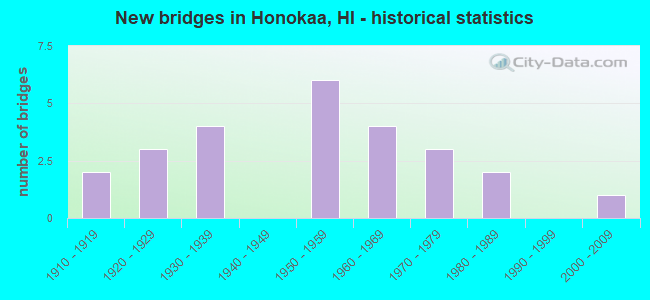
- New bridges - historical statistics
- 21910-1919
- 31920-1929
- 41930-1939
- 61950-1959
- 41960-1969
- 31970-1979
- 21980-1989
- 12000-2009


- Bridge Condition - Deck
- 40.0%Good
- 40.0%Satisfactory
- 20.0%Fair

- Bridge Condition - Superstructure
- 40.0%Good
- 40.0%Satisfactory
- 15.0%Fair
- 5.0%Poor

- Bridge Condition - Substructure
- 60.0%Good
- 20.0%Satisfactory
- 20.0%Fair

- Bridge Condition - Channel
- 28.0%Very good
- 28.0%Good
- 20.0%Satisfactory
- 24.0%Fair

- Bridge Condition - Culverts
- 20.0%Very good
- 40.0%Good
- 40.0%Satisfactory
Find on map >> Show street view
Structure Number: 1000190305585, Location: 0.98MI W/PAKALANA ST (Lat: 20.070506, Lng: -155.479061), Route carried "on" structure: US 19, Year Built: 1963, Status: Open, Structure Length: 5.06m (16.60ft), Average Daily Traffic: 8,600 (year 2017), Truck Traffic: 5%, Average Future Daily Traffic: 7,746 (year 2025), Design Load: HS 20, Features Intersected: NIENIE STRM, Facility Carried by Structure: HAWAII BELT RD
Minimum Vertical Clearance: 30+ m (98+ ft), Kilometerpoint: 70.375, Lanes on structure: 2, Base Highway Network: Yes, Owner: State Highway Agency, Approaching Roadway Width: 12.2m (40.0ft), Material/Design: Concrete, Design/Construction: Box Beam or Girders - Multiple, Number Of Spans In Main Unit: 2, Length of Maximum Span: 24.4m (80.1ft), Curb or Sidewalk Widths: Left: 1.2m (3.9ft), Right: 0.6m (2.0ft), Curb-To-Curb Width: 8.5m (27.9ft), Out-to-Out Width: 11.0m (36.1ft)
Condition: Deck: Satisfactory, Superstructure: Satisfactory, Substructure: Satisfactory, Channel: Very good, Operating Rating: 36.3 metric tons, Method Used To Determine Operating Rating: Load and Resistance Factor Rating (LRFR) rating reported by rating factor(RF) method using HL-93 loadings, Inventory Rating: 27.9 metric tons, Method Used To Determine Inventory Rating: Load and Resistance Factor Rating (LRFR) rating reported by rating factor(RF) method using HL-93 loadings, Structural Evaluation: Equal to present minimum criteria, Deck Geometry: High priority of replacement, Waterway Adequacy: Equal to present minimum criteria, Approach Roadway Alignment: Better than present minimum criteria, Length Of Structure Improvement: 6.08m (19.95ft), Designated Inspection Frequency: Every 24 months, Inspection Date: March 2020, Roadway Improvement Cost: $55,000, Total Project Cost: $823,000, Deck Structure Type: Concrete Cast-file-Place
Find on map >> Show street view
Structure Number: 1000190305755, Location: 0.72MI E/PAKALANA ST (Lat: 20.068483, Lng: -155.453767), Route carried "on" structure: US 19, Year Built: 1953, Status: Open, Structure Length: 0.82m (2.69ft), Average Daily Traffic: 7,100 (year 2017), Truck Traffic: 5%, Average Future Daily Traffic: 5,720 (year 2025), Design Load: HS 20, Features Intersected: KAHAUPU STRM, Facility Carried by Structure: HAWAII BELT RD
Minimum Vertical Clearance: 30+ m (98+ ft), Kilometerpoint: 67.639, Lanes on structure: 2, Base Highway Network: Yes, Owner: State Highway Agency, Approaching Roadway Width: 11.0m (36.1ft), Material/Design: Concrete continuous, Design/Construction: Culvert, Number Of Spans In Main Unit: 2, Length of Maximum Span: 4.0m (13.1ft), Curb-To-Curb Width: 11.0m (36.1ft), Out-to-Out Width: 11.7m (38.4ft)
Condition: Channel: Fair, Culverts: Satisfactory, Operating Rating: 42.6 metric tons, Method Used To Determine Operating Rating: Allowable Stress (AS), Inventory Rating: 19.1 metric tons, Method Used To Determine Inventory Rating: Allowable Stress (AS), Structural Evaluation: Meets minimum limits, Deck Geometry: Meets minimum limits, Waterway Adequacy: Better than present minimum criteria, Approach Roadway Alignment: Equal to present minimum criteria, Designated Inspection Frequency: Every 24 months, Inspection Date: March 2020, Roadway Improvement Cost: $14,000, Total Project Cost: $213,000, Deck Structure Type: Concrete Cast-file-Place
Find on map >> Show street view
Structure Number: 1000190305863, Location: 0.83MI E/MAMANE ST (Lat: 20.067319, Lng: -155.438058), Route carried "on" structure: US 19, Year Built: 1959, Status: Open, Structure Length: 6.61m (21.69ft), Average Daily Traffic: 7,200 (year 2017), Truck Traffic: 9%, Average Future Daily Traffic: 6,969 (year 2025), Design Load: HS 20, Features Intersected: KAHAWAILIILII STRM, Facility Carried by Structure: HAWAII BELT RD
Minimum Vertical Clearance: 30+ m (98+ ft), Kilometerpoint: 65.853, Lanes on structure: 2, Base Highway Network: Yes, Owner: State Highway Agency, Approaching Roadway Width: 12.2m (40.0ft), Skew: 3 degrees, Material/Design: Concrete continuous, Design/Construction: Box Beam or Girders - Multiple, Number Of Spans In Main Unit: 3, Length of Maximum Span: 32.6m (107.0ft), Curb or Sidewalk Widths: Left: 1.2m (3.9ft), Right: 1.2m (3.9ft), Curb-To-Curb Width: 8.5m (27.9ft), Out-to-Out Width: 11.7m (38.4ft)
Condition: Deck: Good, Superstructure: Satisfactory, Substructure: Good, Channel: Very good, Operating Rating: 41.1 metric tons, Method Used To Determine Operating Rating: Load and Resistance Factor Rating (LRFR) rating reported by rating factor(RF) method using HL-93 loadings, Inventory Rating: 31.8 metric tons, Method Used To Determine Inventory Rating: Load and Resistance Factor Rating (LRFR) rating reported by rating factor(RF) method using HL-93 loadings, Structural Evaluation: Equal to present minimum criteria, Deck Geometry: Meets minimum limits, Waterway Adequacy: Better than present minimum criteria, Approach Roadway Alignment: Better than present minimum criteria, Designated Inspection Frequency: Every 24 months, Inspection Date: March 2020, Roadway Improvement Cost: $73,000, Total Project Cost: $1,101,000, Deck Structure Type: Concrete Cast-file-Place
Find on map >> Show street view
Structure Number: 1000190306021, Location: 2.41MI E/MAMANE ST (Lat: 20.061472, Lng: -155.414758), Route carried "on" structure: US 19, Year Built: 1959, Status: Open, Structure Length: 10.09m (33.10ft), Average Daily Traffic: 7,200 (year 2017), Truck Traffic: 9%, Average Future Daily Traffic: 6,969 (year 2025), Design Load: HS 20, Features Intersected: KALOPA STRM, Facility Carried by Structure: HAWAII BELT RD
Minimum Vertical Clearance: 30+ m (98+ ft), Kilometerpoint: 63.294, Lanes on structure: 2, Base Highway Network: Yes, Owner: State Highway Agency, Approaching Roadway Width: 12.2m (40.0ft), Material/Design: Concrete continuous, Design/Construction: Box Beam or Girders - Multiple, Number Of Spans In Main Unit: 3, Length of Maximum Span: 38.1m (125.0ft), Curb or Sidewalk Widths: Left: 1.2m (3.9ft), Right: 1.2m (3.9ft), Curb-To-Curb Width: 8.5m (27.9ft), Out-to-Out Width: 11.7m (38.4ft)
Condition: Deck: Good, Superstructure: Satisfactory, Substructure: Good, Channel: Very good, Operating Rating: 36.3 metric tons, Method Used To Determine Operating Rating: Load and Resistance Factor Rating (LRFR) rating reported by rating factor(RF) method using HL-93 loadings, Inventory Rating: 28.2 metric tons, Method Used To Determine Inventory Rating: Load and Resistance Factor Rating (LRFR) rating reported by rating factor(RF) method using HL-93 loadings, Structural Evaluation: Equal to present minimum criteria, Deck Geometry: Meets minimum limits, Waterway Adequacy: Better than present minimum criteria, Approach Roadway Alignment: Better than present minimum criteria, Designated Inspection Frequency: Every 24 months, Inspection Date: March 2020, Roadway Improvement Cost: $106,000, Total Project Cost: $1,585,000, Deck Structure Type: Concrete Cast-file-Place, Wearing Surface/Protective System: Wearing Surface: Bituminous
Find on map >> Show street view
Structure Number: 1000190306165, Location: 3.85MI E/MAMANE ST (Lat: 20.051056, Lng: -155.396014), Route carried "on" structure: US 19, Year Built: 1959, Status: Open, Structure Length: 2.59m (8.50ft), Average Daily Traffic: 7,200 (year 2017), Truck Traffic: 9%, Average Future Daily Traffic: 6,969 (year 2025), Design Load: HS 20, Features Intersected: KAUMOALII STRM, Facility Carried by Structure: HAWAII BELT RD
Minimum Vertical Clearance: 30+ m (98+ ft), Kilometerpoint: 61.025, Lanes on structure: 2, Base Highway Network: Yes, Owner: State Highway Agency, Approaching Roadway Width: 11.6m (38.1ft), Material/Design: Concrete continuous, Design/Construction: Tee Beam, Number Of Spans In Main Unit: 2, Length of Maximum Span: 12.2m (40.0ft), Curb or Sidewalk Widths: Left: 1.2m (3.9ft), Right: 1.2m (3.9ft), Curb-To-Curb Width: 8.5m (27.9ft), Out-to-Out Width: 11.7m (38.4ft)
Condition: Deck: Satisfactory, Superstructure: Satisfactory, Substructure: Good, Channel: Very good, Operating Rating: 61.2 metric tons, Method Used To Determine Operating Rating: Load and Resistance Factor Rating (LRFR) rating reported by rating factor(RF) method using HL-93 loadings, Inventory Rating: 47.0 metric tons, Method Used To Determine Inventory Rating: Load and Resistance Factor Rating (LRFR) rating reported by rating factor(RF) method using HL-93 loadings, Structural Evaluation: Equal to present minimum criteria, Deck Geometry: High priority of replacement, Waterway Adequacy: Equal to present desirable criteria, Approach Roadway Alignment: Equal to present minimum criteria, Length Of Structure Improvement: 3.49m (11.45ft), Designated Inspection Frequency: Every 24 months, Inspection Date: March 2020, Roadway Improvement Cost: $33,000, Total Project Cost: $502,000, Deck Structure Type: Concrete Cast-file-Place, Wearing Surface/Protective System: Wearing Surface: Bituminous
Find on map >> Show street view
Structure Number: 100019030628, Location: 5.00MI E/MAMANE ST (Lat: 20.045153, Lng: -155.379342), Route carried "on" structure: US 19, Year Built: 1959, Status: Open, Structure Length: 5.79m (19.00ft), Average Daily Traffic: 7,200 (year 2017), Truck Traffic: 9%, Average Future Daily Traffic: 7,410 (year 2025), Design Load: HS 20, Features Intersected: WAIPUNAHINA STRM, Facility Carried by Structure: HAWAII BELT RD
Minimum Vertical Clearance: 30+ m (98+ ft), Kilometerpoint: 59.142, Lanes on structure: 2, Base Highway Network: Yes, Owner: State Highway Agency, Approaching Roadway Width: 12.2m (40.0ft), Material/Design: Concrete continuous, Design/Construction: Box Beam or Girders - Multiple, Number Of Spans In Main Unit: 2, Length of Maximum Span: 28.0m (91.9ft), Curb or Sidewalk Widths: Left: 1.2m (3.9ft), Right: 1.2m (3.9ft), Curb-To-Curb Width: 8.5m (27.9ft), Out-to-Out Width: 11.7m (38.4ft)
Condition: Deck: Good, Superstructure: Satisfactory, Substructure: Good, Channel: Very good, Operating Rating: 38.2 metric tons, Method Used To Determine Operating Rating: Load and Resistance Factor Rating (LRFR) rating reported by rating factor(RF) method using HL-93 loadings, Inventory Rating: 29.5 metric tons, Method Used To Determine Inventory Rating: Load and Resistance Factor Rating (LRFR) rating reported by rating factor(RF) method using HL-93 loadings, Structural Evaluation: Equal to present minimum criteria, Deck Geometry: High priority of replacement, Waterway Adequacy: Better than present minimum criteria, Approach Roadway Alignment: Better than present minimum criteria, Length Of Structure Improvement: 6.83m (22.41ft), Designated Inspection Frequency: Every 24 months, Inspection Date: March 2020, Roadway Improvement Cost: $66,000, Total Project Cost: $983,000, Deck Structure Type: Concrete Cast-file-Place, Wearing Surface/Protective System: Wearing Surface: Bituminous
Find on map >> Show street view
Structure Number: 1002400500044, Location: 0.44MI/WAIPIO VLLY LO PT (Lat: 20.115661, Lng: -155.577967), Route carried "on" structure: US 240, Year Built: 1979, Status: Open, Structure Length: 3.05m (10.01ft), Average Daily Traffic: 980 (year 2017), Truck Traffic: 2%, Average Future Daily Traffic: 2,443 (year 2025), Design Load: HS 20, Features Intersected: WAIULILI STRM, Facility Carried by Structure: HONOKAA-WAIPIO RD
Minimum Vertical Clearance: 30+ m (98+ ft), Kilometerpoint: 14.773, Lanes on structure: 2, Owner: State Highway Agency, Approaching Roadway Width: 11.0m (36.1ft), Skew: 5 degrees, Material/Design: Prestressed concrete, Design/Construction: Girder and Floorbeam System, Number Of Spans In Main Unit: 1, Length of Maximum Span: 30.5m (100.1ft), Curb-To-Curb Width: 11.0m (36.1ft), Out-to-Out Width: 12.0m (39.4ft)
Condition: Deck: Good, Superstructure: Good, Substructure: Satisfactory, Channel: Good, Operating Rating: 43.5 metric tons, Method Used To Determine Operating Rating: Allowable Stress (AS), Inventory Rating: 30.8 metric tons, Method Used To Determine Inventory Rating: Allowable Stress (AS), Structural Evaluation: Equal to present minimum criteria, Deck Geometry: Better than present minimum criteria, Waterway Adequacy: Better than present minimum criteria, Approach Roadway Alignment: Equal to present desirable criteria, Designated Inspection Frequency: Every 24 months, Inspection Date: March 2020, Deck Structure Type: Concrete Cast-file-Place
Find on map >> Show street view
Structure Number: 1002400500194, Location: 0.85MI E/CEMETARY RD (Lat: 20.113619, Lng: -155.556181), Route carried "on" structure: Spur US 240, Year Built: 1972, Status: Open, Structure Length: 2.04m (6.69ft), Average Daily Traffic: 1,800 (year 2017), Truck Traffic: 2%, Average Future Daily Traffic: 2,750 (year 2025), Design Load: HS 20, Features Intersected: WAIPUNAHOE STRM, Facility Carried by Structure: HONOKAA-PAAHAU RD
Minimum Vertical Clearance: 30+ m (98+ ft), Kilometerpoint: 12.440, Lanes on structure: 2, Owner: State Highway Agency, Approaching Roadway Width: 12.2m (40.0ft), Material/Design: Prestressed concrete, Design/Construction: Stringer/Multi-beam, Number Of Spans In Main Unit: 1, Length of Maximum Span: 19.8m (65.0ft), Curb-To-Curb Width: 11.0m (36.1ft), Out-to-Out Width: 12.0m (39.4ft)
Condition: Deck: Satisfactory, Superstructure: Good, Substructure: Good, Channel: Good, Operating Rating: 39.0 metric tons, Method Used To Determine Operating Rating: Allowable Stress (AS), Inventory Rating: 22.7 metric tons, Method Used To Determine Inventory Rating: Allowable Stress (AS), Structural Evaluation: Equal to present minimum criteria, Deck Geometry: Equal to present minimum criteria, Waterway Adequacy: Better than present minimum criteria, Approach Roadway Alignment: Better than present minimum criteria, Designated Inspection Frequency: Every 24 months, Inspection Date: March 2020, Roadway Improvement Cost: $28,000, Total Project Cost: $413,000, Deck Structure Type: Concrete Cast-file-Place
Find on map >> Show street view
Structure Number: 1002400500282, Location: 1.74MI E/CEMETARY RD (Lat: 20.109092, Lng: -155.543475), Route carried "on" structure: Spur US 240, Year Built: 1971, Status: Open, Structure Length: 3.51m (11.52ft), Average Daily Traffic: 1,800 (year 2017), Truck Traffic: 2%, Average Future Daily Traffic: 2,443 (year 2025), Design Load: HS 20, Features Intersected: WAIKALOA STRM, Facility Carried by Structure: HONOKAA-PAAHAU RD
Minimum Vertical Clearance: 30+ m (98+ ft), Kilometerpoint: 11.024, Lanes on structure: 2, Owner: State Highway Agency, Approaching Roadway Width: 11.0m (36.1ft), Material/Design: Prestressed concrete, Design/Construction: Stringer/Multi-beam, Number Of Spans In Main Unit: 2, Length of Maximum Span: 17.4m (57.1ft), Curb-To-Curb Width: 11.0m (36.1ft), Out-to-Out Width: 12.0m (39.4ft)
Condition: Deck: Good, Superstructure: Good, Substructure: Good, Channel: Good, Operating Rating: 51.7 metric tons, Method Used To Determine Operating Rating: Allowable Stress (AS), Inventory Rating: 29.0 metric tons, Method Used To Determine Inventory Rating: Allowable Stress (AS), Structural Evaluation: Better than present minimum criteria, Deck Geometry: Equal to present minimum criteria, Waterway Adequacy: Better than present minimum criteria, Approach Roadway Alignment: Equal to present minimum criteria, Designated Inspection Frequency: Every 24 months, Inspection Date: March 2020, Deck Structure Type: Concrete Cast-file-Place
Find on map >> Show street view
Structure Number: 1002400500691, Location: 1.14MI W/KAHILI ST (Lat: 20.084414, Lng: -155.491153), Route carried "on" structure: Spur US 240, Year Built: 1966, Status: Open, Structure Length: 1.55m (5.09ft), Average Daily Traffic: 1,800 (year 2017), Truck Traffic: 2%, Average Future Daily Traffic: 2,443 (year 2025), Design Load: HS 20, Features Intersected: KAINAPAHOA STRM, Facility Carried by Structure: HONOKAA-PAAHAU RD
Minimum Vertical Clearance: 30+ m (98+ ft), Kilometerpoint: 4.458, Lanes on structure: 2, Owner: State Highway Agency, Approaching Roadway Width: 11.0m (36.1ft), Material/Design: Steel, Design/Construction: Culvert, Number Of Spans In Main Unit: 3, Length of Maximum Span: 4.3m (14.1ft), Curb-To-Curb Width: 11.0m (36.1ft), Out-to-Out Width: 12.0m (39.4ft)
Condition: Channel: Satisfactory, Culverts: Good, Operating Rating: 45.4 metric tons, Method Used To Determine Operating Rating: Allowable Stress (AS), Inventory Rating: 32.7 metric tons, Method Used To Determine Inventory Rating: Allowable Stress (AS), Structural Evaluation: Better than present minimum criteria, Deck Geometry: Equal to present minimum criteria, Waterway Adequacy: Meets minimum limits, Approach Roadway Alignment: Equal to present minimum criteria, Designated Inspection Frequency: Every 24 months, Inspection Date: March 2020, Total Project Cost: $598,000, Deck Structure Type: Concrete Cast-file-Place
Find on map >> Show street view
Structure Number: 1002400500733, Location: 0.72MI W/KAHILI ST (Lat: 20.083572, Lng: -155.485342), Route carried "on" structure: Spur US 240, Year Built: 1966, Status: Open, Structure Length: 0.73m (2.40ft), Average Daily Traffic: 1,800 (year 2017), Truck Traffic: 2%, Average Future Daily Traffic: 2,443 (year 2025), Design Load: HS 20, Features Intersected: AHUALOA STRM, Facility Carried by Structure: HONOKAA-PAAHAU RD
Minimum Vertical Clearance: 30+ m (98+ ft), Kilometerpoint: 3.782, Lanes on structure: 2, Owner: State Highway Agency, Approaching Roadway Width: 11.0m (36.1ft), Material/Design: Steel, Design/Construction: Culvert, Number Of Spans In Main Unit: 2, Length of Maximum Span: 3.0m (9.8ft), Curb-To-Curb Width: 11.0m (36.1ft), Out-to-Out Width: 12.0m (39.4ft)
Condition: Channel: Very good, Culverts: Good, Operating Rating: 45.4 metric tons, Method Used To Determine Operating Rating: Allowable Stress (AS), Inventory Rating: 30.8 metric tons, Method Used To Determine Inventory Rating: Allowable Stress (AS), Structural Evaluation: Better than present minimum criteria, Deck Geometry: Equal to present minimum criteria, Waterway Adequacy: Better than present minimum criteria, Approach Roadway Alignment: Equal to present minimum criteria, Designated Inspection Frequency: Every 24 months, Inspection Date: March 2020
Find on map >> Show street view
Structure Number: 1002400500771, Location: 0.49MI W/LEHUA AVE (Lat: 20.080914, Lng: -155.476464), Route carried "on" structure: Spur US 240, Year Built: 1967, Status: Open, Structure Length: 2.44m (8.01ft), Average Daily Traffic: 1,800 (year 2017), Truck Traffic: 2%, Average Future Daily Traffic: 4,996 (year 2025), Design Load: HS 20, Features Intersected: NIENIE STRM, Facility Carried by Structure: HONOKAA-PAAHAU RD
Minimum Vertical Clearance: 30+ m (98+ ft), Kilometerpoint: 3.154, Lanes on structure: 2, Owner: State Highway Agency, Approaching Roadway Width: 11.0m (36.1ft), Material/Design: Concrete continuous, Design/Construction: Tee Beam, Number Of Spans In Main Unit: 1, Length of Maximum Span: 22.9m (75.1ft), Curb or Sidewalk Widths: Left: 1.2m (3.9ft), Right: 0.6m (2.0ft), Curb-To-Curb Width: 8.5m (27.9ft), Out-to-Out Width: 11.0m (36.1ft)
Condition: Deck: Satisfactory, Superstructure: Good, Substructure: Good, Channel: Good, Operating Rating: 51.5 metric tons, Method Used To Determine Operating Rating: Load and Resistance Factor Rating (LRFR) rating reported by rating factor(RF) method using HL-93 loadings, Inventory Rating: 39.9 metric tons, Method Used To Determine Inventory Rating: Load and Resistance Factor Rating (LRFR) rating reported by rating factor(RF) method using HL-93 loadings, Structural Evaluation: Better than present minimum criteria, Deck Geometry: Somewhat better than minimum adequacy, Waterway Adequacy: Better than present minimum criteria, Approach Roadway Alignment: Equal to present minimum criteria, Designated Inspection Frequency: Every 24 months, Inspection Date: March 2020, Roadway Improvement Cost: $30,000, Total Project Cost: $447,000, Deck Structure Type: Concrete Cast-file-Place
Find on map >> Show street view
Structure Number: 1002400500949, Location: 0.19MI W/MAMALAHOA HWY (Lat: 20.070783, Lng: -155.451872), Route carried "on" structure: Spur US 240, Year Built: 1953, Status: Open, Structure Length: 0.82m (2.69ft), Average Daily Traffic: 2,600 (year 2017), Truck Traffic: 2%, Average Future Daily Traffic: 4,625 (year 2025), Design Load: HS 20, Features Intersected: KAHAUPU STRM, Facility Carried by Structure: HONOKAA-PAAHAU RD
Minimum Vertical Clearance: 30+ m (98+ ft), Kilometerpoint: 0.306, Lanes on structure: 2, Owner: State Highway Agency, Approaching Roadway Width: 11.0m (36.1ft), Material/Design: Concrete continuous, Design/Construction: Culvert, Number Of Spans In Main Unit: 2, Length of Maximum Span: 3.7m (12.1ft), Curb-To-Curb Width: 43.1m (141.4ft), Out-to-Out Width: 44.1m (144.7ft)
Condition: Channel: Very good, Culverts: Satisfactory, Operating Rating: 43.5 metric tons, Method Used To Determine Operating Rating: Allowable Stress (AS), Inventory Rating: 24.5 metric tons, Method Used To Determine Inventory Rating: Allowable Stress (AS), Structural Evaluation: Equal to present minimum criteria, Deck Geometry: Superior to present desirable criteria, Waterway Adequacy: Better than present minimum criteria, Approach Roadway Alignment: Equal to present minimum criteria, Designated Inspection Frequency: Every 24 months, Inspection Date: March 2020, Roadway Improvement Cost: $53,000, Total Project Cost: $802,000
Find on map >> Show street view
Structure Number: 1440001100006, Location: TMK 4-4-09:9 (Lat: 20.050186, Lng: -155.419861), Route carried "on" structure: County highway , Year Built: 1930, Status: Posted for load, Structure Length: 0.70m (2.30ft), Average Daily Traffic: 40 (year 1980), Average Future Daily Traffic: 50 (year 2025), Features Intersected: KALOPA/WAIKAALULU GLH, Facility Carried by Structure: KAAPAHU RD
Minimum Vertical Clearance: 30+ m (98+ ft), Kilometerpoint: 0.000, Lanes on structure: 1, Owner: County Highway Agency, Approaching Roadway Width: 4.6m (15.1ft), Material/Design: Wood or Timber, Design/Construction: Stringer/Multi-beam, Number Of Spans In Main Unit: 1, Length of Maximum Span: 6.1m (20.0ft), Curb-To-Curb Width: 4.2m (13.8ft), Out-to-Out Width: 4.9m (16.1ft)
Condition: Deck: Satisfactory, Superstructure: Satisfactory, Substructure: Fair, Channel: Satisfactory, Operating Rating: 18.5 metric tons, Method Used To Determine Operating Rating: Load and Resistance Factor Rating (LRFR) rating reported by rating factor(RF) method using HL-93 loadings, Inventory Rating: 14.3 metric tons, Method Used To Determine Inventory Rating: Load and Resistance Factor Rating (LRFR) rating reported by rating factor(RF) method using HL-93 loadings, Structural Evaluation: Meets minimum limits, Deck Geometry: Somewhat better than minimum adequacy, Waterway Adequacy: Better than present minimum criteria, Approach Roadway Alignment: Equal to present minimum criteria, Bridge Posting: Required (Relationship of Operating Rating to Maximum Legal Load: > 39.9% below), Designated Inspection Frequency: Every 24 months, Inspection Date: July 2020, Total Project Cost: $150,000, Deck Structure Type: Wood or Timber, Wearing Surface/Protective System: Wearing Surface: Wood or Timber
Find on map >> Show street view
Structure Number: 1440001100007, Location: TMK 4-4-08:2 (Lat: 20.051281, Lng: -155.421431), Route carried "on" structure: County highway , Year Built: 1919, Status: Open, Structure Length: 1.46m (4.79ft), Average Daily Traffic: 40 (year 1981), Average Future Daily Traffic: 50 (year 2025), Features Intersected: KALOPA/KALOPA GLH, Facility Carried by Structure: KALOPA
Minimum Vertical Clearance: 30+ m (98+ ft), Kilometerpoint: 0.000, Lanes on structure: 1, Owner: County Highway Agency, Approaching Roadway Width: 6.1m (20.0ft), Material/Design: Concrete continuous, Design/Construction: Stringer/Multi-beam, Number Of Spans In Main Unit: 2, Length of Maximum Span: 6.1m (20.0ft), Curb-To-Curb Width: 4.3m (14.1ft), Out-to-Out Width: 4.9m (16.1ft)
Condition: Deck: Satisfactory, Superstructure: Satisfactory, Substructure: Satisfactory, Channel: Fair, Operating Rating: 55.1 metric tons, Method Used To Determine Operating Rating: Load and Resistance Factor Rating (LRFR) rating reported by rating factor(RF) method using HL-93 loadings, Inventory Rating: 42.4 metric tons, Method Used To Determine Inventory Rating: Load and Resistance Factor Rating (LRFR) rating reported by rating factor(RF) method using HL-93 loadings, Structural Evaluation: Equal to present minimum criteria, Deck Geometry: Equal to present minimum criteria, Waterway Adequacy: Equal to present minimum criteria, Approach Roadway Alignment: Equal to present minimum criteria, Length Of Structure Improvement: 2.14m (7.02ft), Designated Inspection Frequency: Every 24 months, Inspection Date: July 2020, Roadway Improvement Cost: $17,000, Total Project Cost: $258,000, Deck Structure Type: Concrete Cast-file-Place, Wearing Surface/Protective System: Wearing Surface: Bituminous
Find on map >> Show street view
Structure Number: 1440001100008, Location: TMK 4-4-02:6 (Lat: 20.059694, Lng: -155.413625), Route carried "on" structure: County highway , Year Built: 1930, Status: Posted for load, Structure Length: 1.55m (5.09ft), Average Daily Traffic: 40 (year 1981), Average Future Daily Traffic: 50 (year 2025), Features Intersected: MAMALAHOA/WAIKAALULU GLH, Facility Carried by Structure: MAMALAHOA
Minimum Vertical Clearance: 30+ m (98+ ft), Kilometerpoint: 0.000, Lanes on structure: 1, Owner: County Highway Agency, Approaching Roadway Width: 5.2m (17.1ft), Material/Design: Wood or Timber, Design/Construction: Stringer/Multi-beam, Number Of Spans In Main Unit: 3, Length of Maximum Span: 6.1m (20.0ft), Curb-To-Curb Width: 4.8m (15.7ft), Out-to-Out Width: 5.5m (18.0ft)
Condition: Deck: Fair, Superstructure: Satisfactory, Substructure: Fair, Channel: Fair, Operating Rating: 27.9 metric tons, Method Used To Determine Operating Rating: Load and Resistance Factor Rating (LRFR) rating reported by rating factor(RF) method using HL-93 loadings, Inventory Rating: 21.7 metric tons, Method Used To Determine Inventory Rating: Load and Resistance Factor Rating (LRFR) rating reported by rating factor(RF) method using HL-93 loadings, Structural Evaluation: Somewhat better than minimum adequacy, Deck Geometry: Equal to present desirable criteria, Waterway Adequacy: Equal to present minimum criteria, Approach Roadway Alignment: Equal to present minimum criteria, Bridge Posting: Required (Relationship of Operating Rating to Maximum Legal Load: > 39.9% below), Designated Inspection Frequency: Every 24 months, Inspection Date: July 2020, Total Project Cost: $300,000, Deck Structure Type: Wood or Timber, Wearing Surface/Protective System: Wearing Surface: Wood or Timber
Find on map >> Show street view
Structure Number: 1440001100009, Location: TMK 4-4-02:7 (Lat: 20.058156, Lng: -155.417897), Route carried "on" structure: County highway , Year Built: 1930, Status: Posted for load, Structure Length: 1.62m (5.31ft), Average Daily Traffic: 90 (year 1981), Average Future Daily Traffic: 113 (year 2025), Features Intersected: MAMALAHOA/KALOPA GLH, Facility Carried by Structure: MAMALAHOA
Minimum Vertical Clearance: 30+ m (98+ ft), Kilometerpoint: 0.000, Lanes on structure: 1, Owner: County Highway Agency, Approaching Roadway Width: 7.0m (23.0ft), Material/Design: Wood or Timber, Design/Construction: Stringer/Multi-beam, Number Of Spans In Main Unit: 3, Length of Maximum Span: 4.6m (15.1ft), Curb-To-Curb Width: 4.5m (14.8ft), Out-to-Out Width: 4.9m (16.1ft)
Condition: Deck: Satisfactory, Superstructure: Good, Substructure: Fair, Channel: Fair, Operating Rating: 11.7 metric tons, Method Used To Determine Operating Rating: Load and Resistance Factor Rating (LRFR) rating reported by rating factor(RF) method using HL-93 loadings, Inventory Rating: 9.1 metric tons, Method Used To Determine Inventory Rating: Load and Resistance Factor Rating (LRFR) rating reported by rating factor(RF) method using HL-93 loadings, Structural Evaluation: High priority of corrective action, Deck Geometry: Equal to present minimum criteria, Waterway Adequacy: Equal to present desirable criteria, Approach Roadway Alignment: Equal to present minimum criteria, Bridge Posting: Required (Relationship of Operating Rating to Maximum Legal Load: > 39.9% below), Designated Inspection Frequency: Every 24 months, Inspection Date: July 2020, Total Project Cost: $441,000, Deck Structure Type: Aluminum, Wearing Surface/Protective System: Deck Protection: Other
Find on map >> Show street view
Structure Number: 144000110001, Location: TMK 4-4-04:4 (Lat: 20.065197, Lng: -155.439256), Route carried "on" structure: County highway , Year Built: 1919, Status: Open, Structure Length: 0.98m (3.22ft), Average Daily Traffic: 90 (year 1981), Average Future Daily Traffic: 113 (year 2025), Features Intersected: PAAUHAU/KAHAWAILIILII GL, Facility Carried by Structure: PAAUHAU
Minimum Vertical Clearance: 30+ m (98+ ft), Kilometerpoint: 0.000, Lanes on structure: 1, Owner: County Highway Agency, Approaching Roadway Width: 6.4m (21.0ft), Material/Design: Concrete, Design/Construction: Stringer/Multi-beam, Number Of Spans In Main Unit: 1, Length of Maximum Span: 7.9m (25.9ft), Curb-To-Curb Width: 5.5m (18.0ft), Out-to-Out Width: 6.1m (20.0ft)
Condition: Deck: Fair, Superstructure: Fair, Substructure: Good, Channel: Good, Operating Rating: 24.0 metric tons, Method Used To Determine Operating Rating: Load and Resistance Factor Rating (LRFR) rating reported by rating factor(RF) method using HL-93 loadings, Inventory Rating: 18.5 metric tons, Method Used To Determine Inventory Rating: Load and Resistance Factor Rating (LRFR) rating reported by rating factor(RF) method using HL-93 loadings, Structural Evaluation: Somewhat better than minimum adequacy, Deck Geometry: Meets minimum limits, Waterway Adequacy: Better than present minimum criteria, Approach Roadway Alignment: Equal to present minimum criteria, Length Of Structure Improvement: 1.65m (5.41ft), Designated Inspection Frequency: Every 24 months, Inspection Date: March 2020, Roadway Improvement Cost: $13,000, Total Project Cost: $199,000, Deck Structure Type: Concrete Cast-file-Place, Wearing Surface/Protective System: Wearing Surface: Bituminous
Find on map >> Show street view
Structure Number: 1460001100001, Location: TMK 4-6-07:49 (Lat: 20.065078, Lng: -155.481025), Route carried "on" structure: Alternate County highway , Year Built: 1923, Status: Open, Structure Length: 1.52m (4.99ft), Average Daily Traffic: 800 (year 1981), Average Future Daily Traffic: 1,000 (year 2025), Features Intersected: MAMALAHOA/NIENIE GLH, Facility Carried by Structure: MAMALAHOA
Minimum Vertical Clearance: 30+ m (98+ ft), Kilometerpoint: 0.000, Lanes on structure: 1, Owner: County Highway Agency, Approaching Roadway Width: 5.5m (18.0ft), Material/Design: Concrete continuous, Design/Construction: Stringer/Multi-beam, Number Of Spans In Main Unit: 2, Length of Maximum Span: 7.6m (24.9ft), Curb-To-Curb Width: 5.5m (18.0ft), Out-to-Out Width: 6.1m (20.0ft)
Condition: Deck: Fair, Superstructure: Poor, Substructure: Good, Channel: Satisfactory, Operating Rating: 29.5 metric tons, Method Used To Determine Operating Rating: Load and Resistance Factor Rating (LRFR) rating reported by rating factor(RF) method using HL-93 loadings, Inventory Rating: 23.0 metric tons, Method Used To Determine Inventory Rating: Load and Resistance Factor Rating (LRFR) rating reported by rating factor(RF) method using HL-93 loadings, Structural Evaluation: Meets minimum limits, Deck Geometry: High priority of replacement, Waterway Adequacy: Better than present minimum criteria, Approach Roadway Alignment: Equal to present minimum criteria, Designated Inspection Frequency: Every 24 months, Inspection Date: June 2020, Total Project Cost: $245,000, Deck Structure Type: Concrete Cast-file-Place, Wearing Surface/Protective System: Wearing Surface: Bituminous
Find on map >> Show street view
Structure Number: 1460001100002, Location: TMK 4-6-07:25 (Lat: 20.061942, Lng: -155.493064), Route carried "on" structure: Alternate County highway , Year Built: 1923, Status: Posted for load, Structure Length: 0.76m (2.49ft), Average Daily Traffic: 800 (year 1981), Average Future Daily Traffic: 1,000 (year 2025), Features Intersected: MAMALAHOA/AHUALOA #2, Facility Carried by Structure: MAMALAHOA
Minimum Vertical Clearance: 30+ m (98+ ft), Kilometerpoint: 0.000, Lanes on structure: 1, Owner: County Highway Agency, Approaching Roadway Width: 5.8m (19.0ft), Skew: 1 degrees, Material/Design: Concrete, Design/Construction: Stringer/Multi-beam, Number Of Spans In Main Unit: 1, Length of Maximum Span: 6.7m (22.0ft), Curb-To-Curb Width: 5.5m (18.0ft), Out-to-Out Width: 6.1m (20.0ft)
Condition: Deck: Satisfactory, Superstructure: Fair, Substructure: Fair, Channel: Fair, Operating Rating: 25.9 metric tons, Method Used To Determine Operating Rating: Load and Resistance Factor Rating (LRFR) rating reported by rating factor(RF) method using HL-93 loadings, Inventory Rating: 20.1 metric tons, Method Used To Determine Inventory Rating: Load and Resistance Factor Rating (LRFR) rating reported by rating factor(RF) method using HL-93 loadings, Structural Evaluation: Somewhat better than minimum adequacy, Deck Geometry: High priority of replacement, Waterway Adequacy: Equal to present minimum criteria, Approach Roadway Alignment: Equal to present desirable criteria, Bridge Posting: Required (Relationship of Operating Rating to Maximum Legal Load: 0.1 - 9.9% below), Designated Inspection Frequency: Every 24 months, Inspection Date: June 2020, Total Project Cost: $170,000, Deck Structure Type: Concrete Cast-file-Place, Wearing Surface/Protective System: Wearing Surface: Bituminous
Find on map >> Show street view
Structure Number: 1460001100003, Location: TMK 4-6-08:20 (Lat: 20.061178, Lng: -155.497606), Route carried "on" structure: Alternate County highway , Year Built: 1982, Status: Open, Structure Length: 1.94m (6.36ft), Average Daily Traffic: 200 (year 1982), Average Future Daily Traffic: 250 (year 2025), Design Load: HS 20, Features Intersected: MAMALAHOA/AHUALOA #1, Facility Carried by Structure: OLD MAMALAHOA HWY
Minimum Vertical Clearance: 30+ m (98+ ft), Kilometerpoint: 0.000, Lanes on structure: 2, Owner: County Highway Agency, Approaching Roadway Width: 7.6m (24.9ft), Skew: 2 degrees, Material/Design: Prestressed concrete, Design/Construction: Stringer/Multi-beam, Number Of Spans In Main Unit: 1, Length of Maximum Span: 18.3m (60.0ft), Curb-To-Curb Width: 8.5m (27.9ft), Out-to-Out Width: 9.1m (29.9ft)
Condition: Deck: Good, Superstructure: Good, Substructure: Good, Channel: Fair, Operating Rating: 33.7 metric tons, Method Used To Determine Operating Rating: Load and Resistance Factor Rating (LRFR) rating reported by rating factor(RF) method using HL-93 loadings, Inventory Rating: 26.2 metric tons, Method Used To Determine Inventory Rating: Load and Resistance Factor Rating (LRFR) rating reported by rating factor(RF) method using HL-93 loadings, Structural Evaluation: Equal to present minimum criteria, Deck Geometry: Equal to present minimum criteria, Waterway Adequacy: Better than present minimum criteria, Approach Roadway Alignment: Equal to present desirable criteria, Designated Inspection Frequency: Every 24 months, Inspection Date: June 2020, Deck Structure Type: Concrete Cast-file-Place, Wearing Surface/Protective System: Wearing Surface: Monolithic Concrete
Find on map >> Show street view
Structure Number: 1460001100004, Location: TMK 4-6-09:36 (Lat: 20.054931, Lng: -155.506722), Route carried "on" structure: Alternate County highway , Year Built: 1925, Status: Open, Structure Length: 0.73m (2.40ft), Average Daily Traffic: 600 (year 1981), Average Future Daily Traffic: 750 (year 2025), Features Intersected: MAMALAHOA/KEAA KAUKAU, Facility Carried by Structure: MAMALAHOA
Minimum Vertical Clearance: 30+ m (98+ ft), Kilometerpoint: 0.000, Lanes on structure: 1, Owner: County Highway Agency, Approaching Roadway Width: 5.8m (19.0ft), Material/Design: Concrete continuous, Design/Construction: Slab, Number Of Spans In Main Unit: 2, Length of Maximum Span: 3.7m (12.1ft), Curb-To-Curb Width: 5.5m (18.0ft), Out-to-Out Width: 6.1m (20.0ft)
Condition: Deck: Fair, Superstructure: Fair, Substructure: Satisfactory, Channel: Satisfactory, Operating Rating: 37.6 metric tons, Method Used To Determine Operating Rating: Load and Resistance Factor Rating (LRFR) rating reported by rating factor(RF) method using HL-93 loadings, Inventory Rating: 29.2 metric tons, Method Used To Determine Inventory Rating: Load and Resistance Factor Rating (LRFR) rating reported by rating factor(RF) method using HL-93 loadings, Structural Evaluation: Somewhat better than minimum adequacy, Deck Geometry: High priority of replacement, Waterway Adequacy: Better than present minimum criteria, Approach Roadway Alignment: Equal to present minimum criteria, Length Of Structure Improvement: 1.37m (4.49ft), Designated Inspection Frequency: Every 24 months, Inspection Date: June 2020, Roadway Improvement Cost: $11,000, Total Project Cost: $166,000, Deck Structure Type: Concrete Cast-file-Place, Wearing Surface/Protective System: Wearing Surface: Bituminous
Find on map >> Show street view
Structure Number: 1460001100005, Location: TMK 4-6-11:35 (Lat: 20.051567, Lng: -155.517506), Route carried "on" structure: County highway , Year Built: 2001, Status: Posted for load, Structure Length: 1.83m (6.00ft), Average Daily Traffic: 700 (year 1985), Average Future Daily Traffic: 875 (year 2025), Features Intersected: MAMALAHOA/INOIONO GLH, Facility Carried by Structure: MAMALAHOA
Minimum Vertical Clearance: 30+ m (98+ ft), Kilometerpoint: 0.000, Lanes on structure: 1, Owner: County Highway Agency, Approaching Roadway Width: 8.5m (27.9ft), Material/Design: Prestressed concrete, Design/Construction: Stringer/Multi-beam, Number Of Spans In Main Unit: 1, Length of Maximum Span: 17.7m (58.1ft), Curb-To-Curb Width: 8.5m (27.9ft), Out-to-Out Width: 9.4m (30.8ft)
Condition: Deck: Good, Superstructure: Good, Substructure: Good, Channel: Satisfactory, Operating Rating: 24.3 metric tons, Method Used To Determine Operating Rating: Load and Resistance Factor Rating (LRFR) rating reported by rating factor(RF) method using HL-93 loadings, Inventory Rating: 22.4 metric tons, Method Used To Determine Inventory Rating: Load and Resistance Factor Rating (LRFR) rating reported by rating factor(RF) method using HL-93 loadings, Structural Evaluation: Somewhat better than minimum adequacy, Deck Geometry: Somewhat better than minimum adequacy, Waterway Adequacy: Better than present minimum criteria, Approach Roadway Alignment: Equal to present desirable criteria, Bridge Posting: Required (Relationship of Operating Rating to Maximum Legal Load: 0.1 - 9.9% below), Designated Inspection Frequency: Every 24 months, Inspection Date: May 2020, Total Project Cost: $446,000, Deck Structure Type: Concrete Cast-file-Place, Wearing Surface/Protective System: Wearing Surface: Bituminous
Find on map >> Show street view
Structure Number: 1460001100006, Location: TMK 4-6-07:23 (Lat: 20.066353, Lng: -155.493994), Route carried "on" structure: County highway , Year Built: 1984, Status: Open, Structure Length: 1.04m (3.41ft), Average Daily Traffic: 700 (year 1985), Average Future Daily Traffic: 875 (year 2025), Design Load: HS 20, Features Intersected: AHUALOA SCH RD/RELIEF, Facility Carried by Structure: KAPUNA RD
Minimum Vertical Clearance: 30+ m (98+ ft), Kilometerpoint: 0.000, Lanes on structure: 2, Owner: County Highway Agency, Approaching Roadway Width: 6.4m (21.0ft), Skew: 1 degrees, Material/Design: Concrete, Design/Construction: Culvert, Number Of Spans In Main Unit: 3, Length of Maximum Span: 3.4m (11.2ft), Curb-To-Curb Width: 7.9m (25.9ft), Out-to-Out Width: 8.7m (28.5ft)
Condition: Channel: Good, Culverts: Very good, Operating Rating: 74.2 metric tons, Method Used To Determine Operating Rating: Load and Resistance Factor Rating (LRFR) rating reported by rating factor(RF) method using HL-93 loadings, Inventory Rating: 57.3 metric tons, Method Used To Determine Inventory Rating: Load and Resistance Factor Rating (LRFR) rating reported by rating factor(RF) method using HL-93 loadings, Structural Evaluation: Equal to present desirable criteria, Deck Geometry: Somewhat better than minimum adequacy, Waterway Adequacy: Equal to present minimum criteria, Approach Roadway Alignment: Equal to present desirable criteria, Designated Inspection Frequency: Every 24 months, Inspection Date: July 2020, Deck Structure Type: Concrete Cast-file-Place, Wearing Surface/Protective System: Wearing Surface: Monolithic Concrete
Find on map >> Show street view
Structure Number: 1460001100008, Location: TMK 4-6-09:44 (Lat: 20.050347, Lng: -155.507283), Route carried "on" structure: County highway , Year Built: 1930, Status: Posted for load, Structure Length: 0.76m (2.49ft), Average Daily Traffic: 700 (year 1985), Average Future Daily Traffic: 875 (year 2025), Features Intersected: 0.35MI/KEAA KAUKAU, Facility Carried by Structure: KAHANA DR
Minimum Vertical Clearance: 30+ m (98+ ft), Kilometerpoint: 0.000, Lanes on structure: 1, Owner: County Highway Agency, Approaching Roadway Width: 3.7m (12.1ft), Skew: 2 degrees, Material/Design: Wood or Timber, Design/Construction: Stringer/Multi-beam, Number Of Spans In Main Unit: 2, Length of Maximum Span: 6.7m (22.0ft), Curb-To-Curb Width: 3.5m (11.5ft), Out-to-Out Width: 3.7m (12.1ft)
Condition: Deck: Good, Superstructure: Good, Substructure: Good, Channel: Good, Operating Rating: 9.7 metric tons, Method Used To Determine Operating Rating: Load and Resistance Factor Rating (LRFR) rating reported by rating factor(RF) method using HL-93 loadings, Inventory Rating: 7.5 metric tons, Method Used To Determine Inventory Rating: Load and Resistance Factor Rating (LRFR) rating reported by rating factor(RF) method using HL-93 loadings, Structural Evaluation: High priority of corrective action, Deck Geometry: High priority of replacement, Waterway Adequacy: Better than present minimum criteria, Approach Roadway Alignment: Better than present minimum criteria, Bridge Posting: Required (Relationship of Operating Rating to Maximum Legal Load: > 39.9% below), Length Of Structure Improvement: 1.41m (4.63ft), Designated Inspection Frequency: Every 24 months, Inspection Date: May 2021, Roadway Improvement Cost: $11,000, Total Project Cost: $170,000, Deck Structure Type: Wood or Timber, Wearing Surface/Protective System: Wearing Surface: Wood or Timber