Bridge Statistics for Hooksett, New Hampshire (NH)
Condition, Traffic, Stress, Structural Evaluation, Project Costs
- National Bridge Inventory (NBI) Statistics
- 15Number of bridges
- 144ft / 44.4mTotal length
- $25,136,000Total costs
- 373,233Total average daily traffic
- 32,048Total average daily truck traffic
- National Bridge Inventory (NBI) Registered Bridges for Hooksett
- No street view available for this location
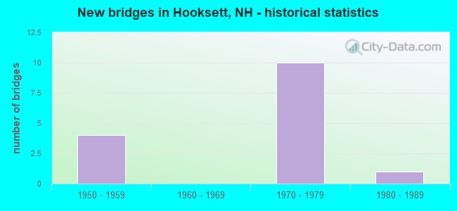
- New bridges - historical statistics
- 41950-1959
- 101970-1979
- 11980-1989

- Reconstructed bridges - Historical Statistics
- 21970-1979
- 11980-1989
- 01990-1999
- 22000-2009
- 12010-2019


- Bridge Condition - Deck
- 14.3%Very good
- 42.9%Good
- 42.9%Satisfactory

- Bridge Condition - Superstructure
- 57.1%Good
- 42.9%Satisfactory

- Bridge Condition - Substructure
- 85.7%Good
- 14.3%Satisfactory
Find on map >> Show street view
Structure Number: 128006800099, Location: AT JCT. WITH FEET. (Lat: 43.056022, Lng: -71.471433), Route carried "on" structure: Ramp Other road 93, Year Built: 1976, Year Reconstructed: 1992, Status: Open, Structure Length: 8.17m (26.80ft), Average Daily Traffic: 658 (year 2020), Truck Traffic: 9%, Average Future Daily Traffic: 973 (year 2042), Design Load: HS 20+Mod, Features Intersected: FEE TPK
Minimum Vertical Clearance: 30+ m (98+ ft), Kilometerpoint: 0.964, Lanes on structure: 1, Lanes under structure: 7, Base Highway Network: Yes, Owner: State Toll Authority, Approaching Roadway Width: 8.2m (26.9ft), Skew: 1 degrees, Material/Design: Steel continuous, Design/Construction: Stringer/Multi-beam, Number Of Spans In Main Unit: 2, Length of Maximum Span: 43.6m (143.0ft), Curb or Sidewalk Widths: Left: 0.1m (0.3ft), Right: 0.1m (0.3ft), Curb-To-Curb Width: 8.2m (26.9ft), Out-to-Out Width: 9.4m (30.8ft)
Condition: Deck: Good, Superstructure: Satisfactory, Substructure: Good, Operating Rating: 46.2 metric tons, Method Used To Determine Operating Rating: Load Factor (LF), Inventory Rating: 27.8 metric tons, Method Used To Determine Inventory Rating: Load Factor (LF), Structural Evaluation: Equal to present minimum criteria, Deck Geometry: Superior to present desirable criteria, Underclear: Equal to present minimum criteria, Approach Roadway Alignment: Equal to present desirable criteria, Length Of Structure Improvement: 8.17m (26.80ft), Designated Inspection Frequency: Every 24 months, Inspection Date: June 2020, Bridge Improvement Cost: $2,718,000, Roadway Improvement Cost: $200,000, Total Project Cost: $3,142,000 ( Estimate for 2022), Deck Structure Type: Concrete Cast-file-Place, Wearing Surface/Protective System: Wearing Surface: Bituminous, Membrane: Preformed Fabric
Find on map >> Show street view
Structure Number: 128006900162, Location: .5 MI SO. BOW TL (Lat: 43.102503, Lng: -71.474975), Route carried "on" structure: City street , Year Built: 1978, Year Reconstructed: 2006, Status: Open, Structure Length: 8.32m (27.30ft), Average Daily Traffic: 1,999 (year 2020), Truck Traffic: 4%, Average Future Daily Traffic: 2,958 (year 2042), Design Load: HS 20+Mod, Features Intersected: I-93,FEE TPK, Facility Carried by Structure: PINE STREET
Minimum Vertical Clearance: 30+ m (98+ ft), Kilometerpoint: 0.764, Lanes on structure: 2, Lanes under structure: 6, Owner: State Toll Authority, Approaching Roadway Width: 13.7m (44.9ft), Skew: 4 degrees, Material/Design: Steel continuous, Design/Construction: Stringer/Multi-beam, Number Of Spans In Main Unit: 2, Length of Maximum Span: 44.2m (145.0ft), Curb or Sidewalk Widths: Left: 1.5m (4.9ft), Right: 0.2m (0.7ft), Curb-To-Curb Width: 13.1m (43.0ft), Out-to-Out Width: 15.5m (50.9ft)
Condition: Deck: Satisfactory, Superstructure: Satisfactory, Substructure: Good, Operating Rating: 44.7 metric tons, Method Used To Determine Operating Rating: Field evaluation and documented engineering judgment, Inventory Rating: 32.7 metric tons, Method Used To Determine Inventory Rating: Field evaluation and documented engineering judgment, Structural Evaluation: Equal to present minimum criteria, Deck Geometry: Better than present minimum criteria, Underclear: Somewhat better than minimum adequacy, Approach Roadway Alignment: Equal to present desirable criteria, Length Of Structure Improvement: 8.32m (27.30ft), Designated Inspection Frequency: Every 24 months, Inspection Date: June 2020, Bridge Improvement Cost: $2,718,000, Roadway Improvement Cost: $200,000, Total Project Cost: $3,142,000 ( Estimate for 2022), Deck Structure Type: Concrete Cast-file-Place, Wearing Surface/Protective System: Wearing Surface: Bituminous, Membrane: Preformed Fabric
Find on map >> Show street view
Structure Number: 128007100114, Location: 2.2 MI NO. MANCHESTER TL (Lat: 43.069111, Lng: -71.471747), Route carried "on" structure: Interstate 93, Year Built: 1956, Year Reconstructed: 1976, Status: Open, Structure Length: 1.01m (3.31ft), Average Daily Traffic: 65,699 (year 2020), Truck Traffic: 9%, Average Future Daily Traffic: 97,234 (year 2042), Design Load: HS 20, Features Intersected: CROSS ROAD
Minimum Vertical Clearance: 30+ m (98+ ft), Kilometerpoint: 45.945, Lanes on structure: 7, Lanes under structure: 2, Base Highway Network: Yes, Toll: On toll road, Owner: State Toll Authority, Approaching Roadway Width: 42.4m (139.1ft), Skew: 30 degrees, Material/Design: Concrete, Design/Construction: Frame, Number Of Spans In Main Unit: 1, Length of Maximum Span: 9.1m (29.9ft), Curb or Sidewalk Widths: Left: 0.2m (0.7ft), Right: 0.2m (0.7ft), Curb-To-Curb Width: 42.4m (139.1ft), Out-to-Out Width: 44.2m (145.0ft)
Condition: Deck: Good, Superstructure: Good, Substructure: Good, Operating Rating: 81.6 metric tons, Method Used To Determine Operating Rating: Load Factor (LF), Inventory Rating: 48.8 metric tons, Method Used To Determine Inventory Rating: Load Factor (LF), Structural Evaluation: Better than present minimum criteria, Deck Geometry: Superior to present desirable criteria, Underclear: High priority of replacement, Approach Roadway Alignment: Equal to present desirable criteria, Length Of Structure Improvement: 1.01m (3.31ft), Designated Inspection Frequency: Every 24 months, Inspection Date: June 2020, Bridge Improvement Cost: $2,718,000, Roadway Improvement Cost: $200,000, Total Project Cost: $3,142,000 ( Estimate for 2022), Deck Structure Type: Concrete Cast-file-Place, Wearing Surface/Protective System: Wearing Surface: Bituminous, Membrane: Preformed Fabric
Find on map >> Show street view
Structure Number: 128007100134, Location: 2.5 MI N. MANCHESTER T.L (Lat: 43.083117, Lng: -71.473208), Route carried "on" structure: Interstate 93, Year Built: 1978, Year Reconstructed: 2012, Status: Open, Structure Length: 2.10m (6.89ft), Average Daily Traffic: 69,552 (year 2020), Truck Traffic: 9%, Average Future Daily Traffic: 102,936 (year 2042), Design Load: HS 20+Mod, Features Intersected: HACKETT HILL ROAD
Minimum Vertical Clearance: 30+ m (98+ ft), Kilometerpoint: 47.506, Lanes on structure: 11, Lanes under structure: 2, Base Highway Network: Yes, Toll: On toll road, Owner: State Toll Authority, Approaching Roadway Width: 34.4m (112.9ft), Skew: 30 degrees, Material/Design: Steel, Design/Construction: Stringer/Multi-beam, Number Of Spans In Main Unit: 1, Length of Maximum Span: 20.1m (65.9ft), Curb-To-Curb Width: 81.7m (268.0ft), Out-to-Out Width: 90.8m (297.9ft)
Condition: Deck: Satisfactory, Superstructure: Good, Substructure: Satisfactory, Operating Rating: 50.8 metric tons, Method Used To Determine Operating Rating: Load Factor (LF), Inventory Rating: 29.9 metric tons, Method Used To Determine Inventory Rating: Load Factor (LF), Structural Evaluation: Equal to present minimum criteria, Deck Geometry: Superior to present desirable criteria, Underclear: Somewhat better than minimum adequacy, Approach Roadway Alignment: Equal to present desirable criteria, Length Of Structure Improvement: 2.10m (6.89ft), Designated Inspection Frequency: Every 24 months, Inspection Date: June 2020, Bridge Improvement Cost: $2,718,000, Roadway Improvement Cost: $200,000, Total Project Cost: $3,142,000 ( Estimate for 2022), Deck Structure Type: Concrete Cast-file-Place, Wearing Surface/Protective System: Wearing Surface: Bituminous, Membrane: Preformed Fabric
Find on map >> Show street view
Structure Number: 128007100138, Location: 2.7 MI NO MANCHESTER TL (Lat: 43.086278, Lng: -71.473936), Route carried "on" structure: Interstate 93, Year Built: 1957, Year Reconstructed: 1978, Status: Open, Structure Length: 1.43m (4.69ft), Average Daily Traffic: 64,039 (year 2020), Truck Traffic: 9%, Average Future Daily Traffic: 94,777 (year 2042), Design Load: HS 20, Features Intersected: RAMP A-B
Minimum Vertical Clearance: 30+ m (98+ ft), Kilometerpoint: 47.864, Lanes on structure: 16, Lanes under structure: 2, Base Highway Network: Yes, Toll: On toll road, Owner: State Toll Authority, Approaching Roadway Width: 35.4m (116.1ft), Material/Design: Concrete, Design/Construction: Frame, Number Of Spans In Main Unit: 1, Length of Maximum Span: 12.2m (40.0ft), Curb or Sidewalk Widths: Left: 1.8m (5.9ft), Right: 1.5m (4.9ft), Curb-To-Curb Width: 42.1m (138.1ft), Out-to-Out Width: 122.5m (401.9ft)
Condition: Deck: Satisfactory, Superstructure: Satisfactory, Substructure: Good, Operating Rating: 89.8 metric tons, Method Used To Determine Operating Rating: Load Factor (LF), Inventory Rating: 60.2 metric tons, Method Used To Determine Inventory Rating: Load Factor (LF), Structural Evaluation: Equal to present minimum criteria, Deck Geometry: High priority of replacement, Underclear: High priority of replacement, Approach Roadway Alignment: Equal to present desirable criteria, Length Of Structure Improvement: 1.43m (4.69ft), Designated Inspection Frequency: Every 24 months, Inspection Date: June 2020, Bridge Improvement Cost: $2,718,000, Roadway Improvement Cost: $200,000, Total Project Cost: $3,142,000 ( Estimate for 2022), Deck Structure Type: Concrete Cast-file-Place, Wearing Surface/Protective System: Wearing Surface: Bituminous, Membrane: Preformed Fabric
Find on map >> Show street view
Structure Number: 128007200136, Location: 2.6 M NORTH MANCHESTER TL (Lat: 43.085664, Lng: -71.472567), Route carried "on" structure: Other road 93, Year Built: 1978, Year Reconstructed: 2015, Status: Open, Structure Length: 2.07m (6.79ft), Average Daily Traffic: 500 (year 2014), Truck Traffic: 9%, Average Future Daily Traffic: 740 (year 2042), Design Load: HS 20+Mod, Features Intersected: I-93 NB OFF RAMP, Facility Carried by Structure: ACCESS ROAD
Minimum Vertical Clearance: 30+ m (98+ ft), Kilometerpoint: 0.288, Lanes on structure: 2, Lanes under structure: 2, Owner: State Toll Authority, Approaching Roadway Width: 8.8m (28.9ft), Skew: 1 degrees, Material/Design: Steel, Design/Construction: Stringer/Multi-beam, Number Of Spans In Main Unit: 1, Length of Maximum Span: 18.9m (62.0ft), Curb or Sidewalk Widths: Left: 0.2m (0.7ft), Right: 0.2m (0.7ft), Curb-To-Curb Width: 8.1m (26.6ft), Out-to-Out Width: 9.4m (30.8ft)
Condition: Deck: Very good, Superstructure: Good, Substructure: Good, Operating Rating: 56.8 metric tons, Method Used To Determine Operating Rating: Load and Resistance Factor (LRFR), Inventory Rating: 43.9 metric tons, Method Used To Determine Inventory Rating: Load and Resistance Factor (LRFR), Structural Evaluation: Better than present minimum criteria, Deck Geometry: Somewhat better than minimum adequacy, Underclear: Equal to present minimum criteria, Approach Roadway Alignment: Equal to present desirable criteria, Length Of Structure Improvement: 2.07m (6.79ft), Designated Inspection Frequency: Every 24 months, Inspection Date: June 2020, Bridge Improvement Cost: $2,718,000, Roadway Improvement Cost: $200,000, Total Project Cost: $3,142,000 ( Estimate for 2022), Deck Structure Type: Concrete Cast-file-Place, Wearing Surface/Protective System: Wearing Surface: Bituminous, Membrane: Preformed Fabric, Deck Protection: Epoxy Coated Reinforcing
Find on map >> Show street view
Structure Number: 128008000148, Location: 0.7 MI N JCT US 3 (Lat: 43.095419, Lng: -71.464436), Route carried "on" structure: City street , Year Built: 1976, Status: Open, Structure Length: 20.57m (67.49ft), Average Daily Traffic: 16,199 (year 2020), Truck Traffic: 4%, Average Future Daily Traffic: 23,974 (year 2042), Design Load: HS 20+Mod, Features Intersected: MERRIMACK RIVER,PAR,RD, Facility Carried by Structure: MAIN STREET
Minimum Vertical Clearance: 30+ m (98+ ft), Kilometerpoint: 0.227, Lanes on structure: 2, Lanes under structure: 2, Base Highway Network: Yes, Owner: State Highway Agency, Approaching Roadway Width: 10.4m (34.1ft), Skew: 1 degrees, Material/Design: Steel continuous, Design/Construction: Stringer/Multi-beam, Number Of Spans In Main Unit: 5, Length of Maximum Span: 53.3m (174.9ft), Curb or Sidewalk Widths: Left: 1.5m (4.9ft), Right: 0.2m (0.7ft), Curb-To-Curb Width: 10.4m (34.1ft), Out-to-Out Width: 12.8m (42.0ft)
Condition: Deck: Good, Superstructure: Good, Substructure: Good, Channel: Good, Operating Rating: 41.9 metric tons, Method Used To Determine Operating Rating: Load and Resistance Factor (LRFR), Inventory Rating: 32.4 metric tons, Method Used To Determine Inventory Rating: Load and Resistance Factor (LRFR), Structural Evaluation: Better than present minimum criteria, Deck Geometry: Meets minimum limits, Underclear: High priority of replacement, Waterway Adequacy: Superior to present desirable criteria, Approach Roadway Alignment: Equal to present desirable criteria, Length Of Structure Improvement: 20.57m (67.49ft), Designated Inspection Frequency: Every 24 months, Underwater Inspection Frequency: Every 60 months, Inspection Date: June 2020, Underwater Inspection Date: June 2020, Bridge Improvement Cost: $2,718,000, Roadway Improvement Cost: $200,000, Total Project Cost: $3,142,000 ( Estimate for 2022), Deck Structure Type: Concrete Cast-file-Place, Wearing Surface/Protective System: Wearing Surface: Bituminous, Membrane: Preformed Fabric
Find on map >> Show street view
Structure Number: 128010000166, Location: 0.7 MI S OF ALLENSTOWN TL (Lat: 43.107506, Lng: -71.448133), Route carried "on" structure: US 3, Year Built: 1981, Status: Open, Structure Length: 0.70m (2.30ft), Average Daily Traffic: 12,535 (year 2020), Truck Traffic: 7%, Average Future Daily Traffic: 18,551 (year 2042), Design Load: HS 20+Mod, Features Intersected: HEADS POND
Minimum Vertical Clearance: 30+ m (98+ ft), Kilometerpoint: 54.520, Lanes on structure: 2, Base Highway Network: Yes, Owner: State Highway Agency, Approaching Roadway Width: 13.4m (44.0ft), Skew: 2 degrees, Material/Design: Concrete, Design/Construction: Culvert, Number Of Spans In Main Unit: 1, Length of Maximum Span: 6.1m (20.0ft)
Condition: Channel: Good, Culverts: Satisfactory, Operating Rating: 89.8 metric tons, Method Used To Determine Operating Rating: Load Factor (LF), Inventory Rating: 64.3 metric tons, Method Used To Determine Inventory Rating: Load Factor (LF), Structural Evaluation: Equal to present minimum criteria, Waterway Adequacy: Equal to present desirable criteria, Approach Roadway Alignment: Equal to present desirable criteria, Length Of Structure Improvement: 0.70m (2.30ft), Designated Inspection Frequency: Every 24 months, Inspection Date: June 2020, Bridge Improvement Cost: $2,718,000, Roadway Improvement Cost: $200,000, Total Project Cost: $3,142,000 ( Estimate for 2022)
Find on map >> Show street view
Structure Number: 128006800099, Location: AT JCT. WITH FEET. (Lat: 43.056022, Lng: -71.471433), Route carried "under" structure: Interstate 93, Year Built: 1976, Structure Length: 0. m, Average Daily Traffic: 55,000 (year 2014), Truck Traffic: 9%, Features Intersected: FEE TPK
Minimum Vertical Clearance: 5.00m (16.40ft), Kilometerpoint: 0.000, Lanes on structure: 1, Lanes under structure: 7, Toll: On toll road, Material/Design: Steel continuous, Design/Construction: Stringer/Multi-beam, Length of Maximum Span: 43.6m (143.0ft)
Find on map >> Show street view
Structure Number: 128006900162, Location: .5 MI SO. BOW TL (Lat: 43.102503, Lng: -71.474975), Route carried "under" structure: Interstate 93, Year Built: 1978, Structure Length: 0. m, Average Daily Traffic: 73,052 (year 2015), Truck Traffic: 9%, Features Intersected: I-93,FEE TPK, Facility Carried by Structure: PINE STREET
Minimum Vertical Clearance: 5.06m (16.60ft), Kilometerpoint: 0.000, Lanes on structure: 2, Lanes under structure: 6, Toll: On toll road, Material/Design: Steel continuous, Design/Construction: Stringer/Multi-beam, Length of Maximum Span: 44.2m (145.0ft)
Find on map >> Show street view
Structure Number: 128007100114, Location: 2.2 MI NO. MANCHESTER TL (Lat: 43.069111, Lng: -71.471747), Route carried "under" structure: City street , Year Built: 1956, Structure Length: 0. m, Average Daily Traffic: 1,300 (year 2013), Truck Traffic: 2%, Features Intersected: CROSS ROAD, Facility Carried by Structure: I-93,FEE TPK
Minimum Vertical Clearance: 4.19m (13.75ft), Kilometerpoint: 0.000, Lanes on structure: 7, Lanes under structure: 2, Material/Design: Concrete, Design/Construction: Frame, Length of Maximum Span: 9.1m (29.9ft)
Find on map >> Show street view
Structure Number: 128007100134, Location: 2.5 MI N. MANCHESTER T.L (Lat: 43.083117, Lng: -71.473208), Route carried "under" structure: City street , Year Built: 1978, Structure Length: 0. m, Average Daily Traffic: 2,800 (year 2014), Truck Traffic: 2%, Features Intersected: HACKETT HILL ROAD, Facility Carried by Structure: I-93,FEE TPK RAMP
Minimum Vertical Clearance: 4.39m (14.40ft), Kilometerpoint: 0.000, Lanes on structure: 11, Lanes under structure: 2, Material/Design: Steel, Design/Construction: Stringer/Multi-beam, Length of Maximum Span: 20.1m (65.9ft)
Find on map >> Show street view
Structure Number: 128007100138, Location: 2.7 MI NO MANCHESTER TL (Lat: 43.086278, Lng: -71.473936), Route carried "under" structure: Ramp Interstate 93, Year Built: 1957, Structure Length: 0. m, Average Daily Traffic: 4,800 (year 1994), Truck Traffic: 9%, Features Intersected: RAMP A-B
Minimum Vertical Clearance: 5.00m (16.40ft), Kilometerpoint: 0.000, Lanes on structure: 16, Lanes under structure: 2, Toll: On toll road, Material/Design: Concrete, Design/Construction: Frame, Length of Maximum Span: 12.2m (40.0ft)
Find on map >> Show street view
Structure Number: 128007200136, Location: 2.6 M NORTH MANCHESTER TL (Lat: 43.085664, Lng: -71.472567), Route carried "under" structure: Ramp Interstate 93R, Year Built: 1978, Structure Length: 0. m, Average Daily Traffic: 4,100 (year 2014), Truck Traffic: 9%, Features Intersected: I-93 NB OFF RAMP, Facility Carried by Structure: ACCESS ROAD
Minimum Vertical Clearance: 5.00m (16.40ft), Kilometerpoint: 0.000, Lanes on structure: 2, Lanes under structure: 1, Toll: On toll road, Material/Design: Steel, Design/Construction: Stringer/Multi-beam, Length of Maximum Span: 18.9m (62.0ft)
Find on map >> Show street view
Structure Number: 128008000148, Location: 0.7 MI N JCT US 3 (Lat: 43.095419, Lng: -71.464436), Route carried "under" structure: City street , Year Built: 1976, Structure Length: 0. m, Average Daily Traffic: 1,000 (year 2015), Features Intersected: MERRIMACK RIVER,PAR,RD, Facility Carried by Structure: MAIN STREET
Minimum Vertical Clearance: 4.37m (14.34ft), Kilometerpoint: 0.000, Lanes on structure: 2, Lanes under structure: 2, Material/Design: Steel continuous, Design/Construction: Stringer/Multi-beam, Length of Maximum Span: 53.3m (174.9ft)