Bridge Statistics for Hoosick, New York (NY)
Condition, Traffic, Stress, Structural Evaluation, Project Costs
- National Bridge Inventory (NBI) Statistics
- 22Number of bridges
- 207ft / 63.2mTotal length
- $42,729,000Total costs
- 72,520Total average daily traffic
- 7,209Total average daily truck traffic
- National Bridge Inventory (NBI) Registered Bridges for Hoosick
- No street view available for this location
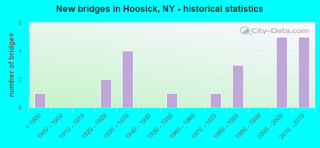
- New bridges - historical statistics
- 1Before 1900
- 21920-1929
- 41930-1939
- 11950-1959
- 11970-1979
- 31980-1989
- 52000-2009
- 52010-2019
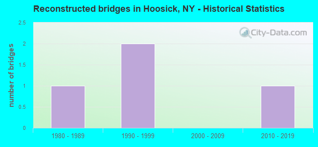
- Reconstructed bridges - Historical Statistics
- 11980-1989
- 21990-1999
- 02000-2009
- 12010-2019
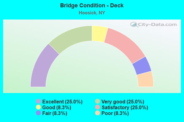
- Bridge Condition - Deck
- 25.0%Excellent
- 25.0%Very good
- 8.3%Good
- 25.0%Satisfactory
- 8.3%Fair
- 8.3%Poor
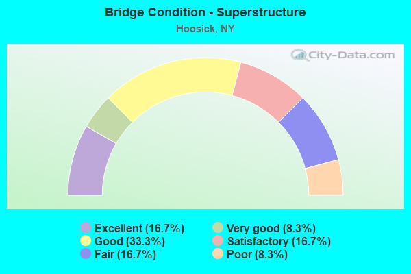
- Bridge Condition - Superstructure
- 16.7%Excellent
- 8.3%Very good
- 33.3%Good
- 16.7%Satisfactory
- 16.7%Fair
- 8.3%Poor
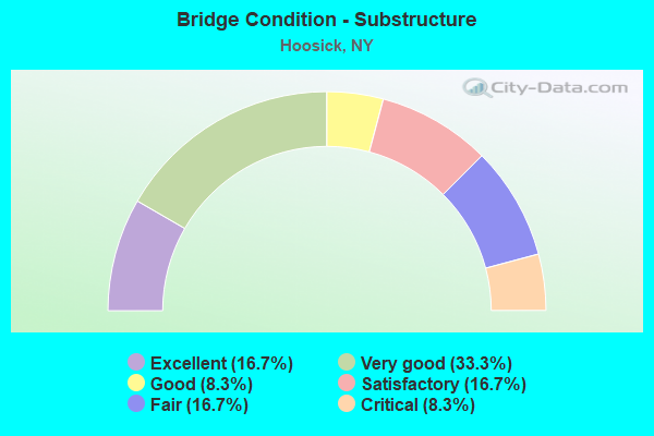
- Bridge Condition - Substructure
- 16.7%Excellent
- 33.3%Very good
- 8.3%Good
- 16.7%Satisfactory
- 16.7%Fair
- 8.3%Critical

- Bridge Condition - Channel
- 7.7%Excellent
- 15.4%Very good
- 15.4%Good
- 30.8%Satisfactory
- 23.1%Fair
- 7.7%Poor
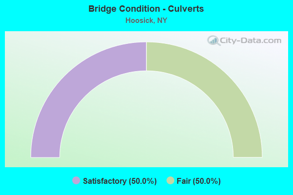
- Bridge Condition - Culverts
- 50.0%Satisfactory
- 50.0%Fair
Find on map >> Show street view
Structure Number: 100429, Location: .1 MI NE JCT SH 7 & SH 22 (Lat: 42.847483, Lng: -73.350608), Route carried "on" structure: State highway 7, Year Built: 1987, Status: Open, Structure Length: 2.47m (8.10ft), Average Daily Traffic: 6,362 (year 2020), Truck Traffic: 13%, Average Future Daily Traffic: 7,127 (year 2040), Design Load: HS 20, Features Intersected: SHINGLE HLLOW BRK
Minimum Vertical Clearance: 30+ m (98+ ft), Kilometerpoint: 33.709, Lanes on structure: 2, Base Highway Network: Yes, Owner: State Highway Agency, Approaching Roadway Width: 12.2m (40.0ft), Skew: 4 degrees, Material/Design: Prestressed concrete, Design/Construction: Box Beam or Girders - Multiple, Number Of Spans In Main Unit: 1, Length of Maximum Span: 23.7m (77.8ft), Curb-To-Curb Width: 13.8m (45.3ft), Out-to-Out Width: 14.8m (48.6ft)
Condition: Deck: Satisfactory, Superstructure: Satisfactory, Substructure: Satisfactory, Channel: Satisfactory, Operating Rating: 92.3 metric tons, Method Used To Determine Operating Rating: Load and Resistance Factor Rating (LRFR) rating reported by rating factor(RF) method using HL-93 loadings, Inventory Rating: 55.7 metric tons, Method Used To Determine Inventory Rating: Load and Resistance Factor Rating (LRFR) rating reported by rating factor(RF) method using HL-93 loadings, Structural Evaluation: Equal to present minimum criteria, Deck Geometry: Superior to present desirable criteria, Waterway Adequacy: Somewhat better than minimum adequacy, Approach Roadway Alignment: Equal to present desirable criteria, Length Of Structure Improvement: 2.46m (8.07ft), Designated Inspection Frequency: Every 24 months, Inspection Date: April 2021, Bridge Improvement Cost: $1,522,000, Roadway Improvement Cost: $891,000, Total Project Cost: $2,413,000 ( Estimate for 2021), Deck Structure Type: Concrete Cast-file-Place, Wearing Surface/Protective System: Wearing Surface: Bituminous
Find on map >> Show street view
Structure Number: 10043, Location: .5 MI SW JCT SH 7 & SH 22 (Lat: 42.852581, Lng: -73.346272), Route carried "on" structure: State highway 7, Year Built: 1932, Year Reconstructed: 1987, Status: Open, Structure Length: 0.73m (2.40ft), Average Daily Traffic: 8,238 (year 2014), Truck Traffic: 10%, Average Future Daily Traffic: 9,229 (year 2040), Design Load: HS 20, Features Intersected: SHINGLE HLLOW BRK
Minimum Vertical Clearance: 30+ m (98+ ft), Kilometerpoint: 34.449, Lanes on structure: 3, Base Highway Network: Yes, Owner: State Highway Agency, Approaching Roadway Width: 16.5m (54.1ft), Material/Design: Concrete continuous, Design/Construction: Culvert, Number Of Spans In Main Unit: 2, Length of Maximum Span: 3.3m (10.8ft)
Condition: Channel: Poor, Culverts: Fair, Inventory Rating: 79.8 metric tons, Method Used To Determine Inventory Rating: Load Factor (LF), Structural Evaluation: Somewhat better than minimum adequacy, Waterway Adequacy: Somewhat better than minimum adequacy, Approach Roadway Alignment: Equal to present desirable criteria, Length Of Structure Improvement: 0.73m (2.40ft), Designated Inspection Frequency: Every 24 months, Inspection Date: March 2021, Bridge Improvement Cost: $212,000, Roadway Improvement Cost: $124,000, Total Project Cost: $337,000 ( Estimate for 2021)
Find on map >> Show street view
Structure Number: 100431, Location: RT 7 0.7 MI SE HOOSICK (Lat: 42.856753, Lng: -73.340161), Route carried "on" structure: State highway 7, Year Built: 2010, Status: Open, Structure Length: 15.48m (50.79ft), Average Daily Traffic: 6,534 (year 2015), Truck Traffic: 10%, Average Future Daily Traffic: 7,320 (year 2040), Design Load: HS 20, Features Intersected: HOOSIC RIVER
Minimum Vertical Clearance: 30+ m (98+ ft), Kilometerpoint: 35.060, Lanes on structure: 2, Base Highway Network: Yes, Owner: State Highway Agency, Approaching Roadway Width: 11.9m (39.0ft), Material/Design: Prestressed concrete continuous, Design/Construction: Tee Beam, Number Of Spans In Main Unit: 4, Length of Maximum Span: 41.3m (135.5ft), Curb-To-Curb Width: 12.0m (39.4ft), Out-to-Out Width: 13.0m (42.7ft)
Condition: Deck: Very good, Superstructure: Good, Substructure: Very good, Channel: Good, Operating Rating: 60.0 metric tons, Method Used To Determine Operating Rating: Load Factor (LF), Inventory Rating: 39.0 metric tons, Method Used To Determine Inventory Rating: Load Factor (LF), Structural Evaluation: Better than present minimum criteria, Deck Geometry: Somewhat better than minimum adequacy, Waterway Adequacy: Equal to present desirable criteria, Approach Roadway Alignment: Equal to present desirable criteria, Length Of Structure Improvement: 15.48m (50.79ft), Designated Inspection Frequency: Every 24 months, Inspection Date: August 2020, Bridge Improvement Cost: $5,381,000, Roadway Improvement Cost: $3,151,000, Total Project Cost: $8,532,000 ( Estimate for 2021), Deck Structure Type: Concrete Cast-file-Place, Wearing Surface/Protective System: Wearing Surface: Integral Concrete, Deck Protection: Epoxy Coated Reinforcing
Find on map >> Show street view
Structure Number: 100432, Location: RT 7 0.5 MI SE HOOSICK (Lat: 42.859411, Lng: -73.335556), Route carried "on" structure: State highway 7, Year Built: 1989, Status: Open, Structure Length: 1.04m (3.41ft), Average Daily Traffic: 6,534 (year 2015), Truck Traffic: 10%, Average Future Daily Traffic: 7,320 (year 2040), Design Load: HS 20, Features Intersected: HOOSIC OVERFLOW
Minimum Vertical Clearance: 30+ m (98+ ft), Kilometerpoint: 35.575, Lanes on structure: 2, Base Highway Network: Yes, Owner: State Highway Agency, Approaching Roadway Width: 12.2m (40.0ft), Skew: 4 degrees, Material/Design: Steel, Design/Construction: Culvert, Number Of Spans In Main Unit: 1, Length of Maximum Span: 7.3m (24.0ft)
Condition: Channel: Good, Culverts: Fair, Operating Rating: 75.7 metric tons, Method Used To Determine Operating Rating: Field evaluation and documented engineering judgment, Inventory Rating: 19.6 metric tons, Method Used To Determine Inventory Rating: Field evaluation and documented engineering judgment, Structural Evaluation: Meets minimum limits, Waterway Adequacy: Equal to present minimum criteria, Approach Roadway Alignment: Equal to present desirable criteria, Length Of Structure Improvement: 1.00m (3.28ft), Designated Inspection Frequency: Every 24 months, Inspection Date: July 2021, Bridge Improvement Cost: $216,000, Roadway Improvement Cost: $127,000, Total Project Cost: $343,000 ( Estimate for 2021)
Find on map >> Show street view
Structure Number: 100433, Location: RTE 7-0.2 MI SE HOOSICK (Lat: 42.861344, Lng: -73.331264), Route carried "on" structure: State highway 7, Year Built: 1986, Status: Open, Structure Length: 4.85m (15.91ft), Average Daily Traffic: 6,534 (year 2015), Truck Traffic: 10%, Average Future Daily Traffic: 7,320 (year 2040), Design Load: HS 20, Features Intersected: SPRG TERM/B & M
Minimum Vertical Clearance: 30+ m (98+ ft), Kilometerpoint: 36.009, Lanes on structure: 2, Base Highway Network: Yes, Owner: State Highway Agency, Approaching Roadway Width: 12.2m (40.0ft), Skew: 1 degrees, Material/Design: Prestressed concrete continuous, Design/Construction: Box Beam or Girders - Multiple, Number Of Spans In Main Unit: 3, Length of Maximum Span: 19.5m (64.0ft), Curb-To-Curb Width: 11.9m (39.0ft), Out-to-Out Width: 12.9m (42.3ft)
Condition: Deck: Fair, Superstructure: Satisfactory, Substructure: Good, Operating Rating: 50.8 metric tons, Method Used To Determine Operating Rating: Load Factor (LF), Inventory Rating: 29.9 metric tons, Method Used To Determine Inventory Rating: Load Factor (LF), Structural Evaluation: Equal to present minimum criteria, Deck Geometry: Somewhat better than minimum adequacy, Underclear: Meets minimum limits, Approach Roadway Alignment: Equal to present desirable criteria, Length Of Structure Improvement: 4.84m (15.88ft), Designated Inspection Frequency: Every 24 months, Inspection Date: June 2020, Bridge Improvement Cost: $1,601,000, Roadway Improvement Cost: $938,000, Total Project Cost: $2,539,000 ( Estimate for 2021), Deck Structure Type: Concrete Cast-file-Place, Wearing Surface/Protective System: Wearing Surface: Monolithic Concrete, Deck Protection: Epoxy Coated Reinforcing
Find on map >> Show street view
Structure Number: 100434, Location: 0.1 MI NW HOOSICK ON SH 7 (Lat: 42.863569, Lng: -73.324181), Route carried "on" structure: State highway 7, Year Built: 1956, Status: Open, Structure Length: 0.76m (2.49ft), Average Daily Traffic: 6,534 (year 2015), Truck Traffic: 10%, Average Future Daily Traffic: 7,320 (year 2040), Features Intersected: BROWNS BROOK
Minimum Vertical Clearance: 30+ m (98+ ft), Kilometerpoint: 36.653, Lanes on structure: 2, Base Highway Network: Yes, Owner: State Highway Agency, Approaching Roadway Width: 10.4m (34.1ft), Skew: 2 degrees, Material/Design: Concrete, Design/Construction: Culvert, Number Of Spans In Main Unit: 1, Length of Maximum Span: 7.3m (24.0ft)
Condition: Channel: Satisfactory, Culverts: Satisfactory, Operating Rating: 81.6 metric tons, Method Used To Determine Operating Rating: Load Factor (LF), Inventory Rating: 48.1 metric tons, Method Used To Determine Inventory Rating: Load Factor (LF), Structural Evaluation: Equal to present minimum criteria, Waterway Adequacy: Somewhat better than minimum adequacy, Approach Roadway Alignment: Equal to present desirable criteria, Length Of Structure Improvement: 0.76m (2.49ft), Designated Inspection Frequency: Every 24 months, Inspection Date: July 2020, Bridge Improvement Cost: $139,000, Roadway Improvement Cost: $82,000, Total Project Cost: $221,000 ( Estimate for 2021), Wearing Surface/Protective System: Wearing Surface: Bituminous
Find on map >> Show street view
Structure Number: 1017, Location: 0.2 MI S JCT RTS 67 & 22 (Lat: 42.926744, Lng: -73.344214), Route carried "on" structure: State highway 22, Year Built: 2018, Status: Open, Structure Length: 8.50m (27.89ft), Average Daily Traffic: 4,261 (year 2018), Truck Traffic: 12%, Average Future Daily Traffic: 4,544 (year 2040), Design Load: HL 93, Features Intersected: FACTORY HILL ROAD, WALLO
Minimum Vertical Clearance: 30+ m (98+ ft), Kilometerpoint: 51.826, Lanes on structure: 2, Lanes under structure: 2, Base Highway Network: Yes, Owner: State Highway Agency, Approaching Roadway Width: 12.2m (40.0ft), Material/Design: Steel continuous, Design/Construction: Stringer/Multi-beam, Number Of Spans In Main Unit: 2, Length of Maximum Span: 46.9m (153.9ft), Curb or Sidewalk Widths: Left: 1.7m (5.6ft), Right: 0.0m, Curb-To-Curb Width: 12.2m (40.0ft), Out-to-Out Width: 15.0m (49.2ft)
Condition: Deck: Excellent, Superstructure: Excellent, Substructure: Excellent, Channel: Very good, Operating Rating: 98.7 metric tons, Method Used To Determine Operating Rating: Field evaluation and documented engineering judgment, Inventory Rating: 40.8 metric tons, Method Used To Determine Inventory Rating: Field evaluation and documented engineering judgment, Structural Evaluation: Superior to present desirable criteria, Deck Geometry: Equal to present minimum criteria, Underclear: Meets minimum limits, Waterway Adequacy: Equal to present desirable criteria, Approach Roadway Alignment: Equal to present desirable criteria, Length Of Structure Improvement: 8.50m (27.89ft), Designated Inspection Frequency: Every 24 months, Underwater Inspection Frequency: Every 60 months, Inspection Date: May 2020, Underwater Inspection Date: May 2018, Bridge Improvement Cost: $2,911,000, Roadway Improvement Cost: $1,705,000, Total Project Cost: $4,616,000 ( Estimate for 2021), Deck Structure Type: Concrete Cast-file-Place, Wearing Surface/Protective System: Wearing Surface: Integral Concrete, Deck Protection: Epoxy Coated Reinforcing
Find on map >> Show street view
Structure Number: 101702, Location: .5 MI W JCT SH 22 & SH 67 (Lat: 42.930333, Lng: -73.349328), Route carried "on" structure: State highway 22, Year Built: 1976, Status: Open, Structure Length: 0.76m (2.49ft), Average Daily Traffic: 4,382 (year 2016), Truck Traffic: 8%, Average Future Daily Traffic: 4,673 (year 2040), Design Load: HS 20, Features Intersected: LITTL WHITE CREEK
Minimum Vertical Clearance: 30+ m (98+ ft), Kilometerpoint: 52.711, Lanes on structure: 2, Base Highway Network: Yes, Owner: State Highway Agency, Approaching Roadway Width: 10.4m (34.1ft), Material/Design: Steel, Design/Construction: Culvert, Number Of Spans In Main Unit: 1, Length of Maximum Span: 6.7m (22.0ft)
Condition: Channel: Fair, Culverts: Satisfactory, Operating Rating: 77.3 metric tons, Method Used To Determine Operating Rating: Field evaluation and documented engineering judgment, Inventory Rating: 32.7 metric tons, Method Used To Determine Inventory Rating: Field evaluation and documented engineering judgment, Structural Evaluation: Equal to present minimum criteria, Waterway Adequacy: Meets minimum limits, Approach Roadway Alignment: Equal to present desirable criteria, Length Of Structure Improvement: 0.76m (2.49ft), Designated Inspection Frequency: Every 24 months, Inspection Date: August 2020, Bridge Improvement Cost: $139,000, Roadway Improvement Cost: $82,000, Total Project Cost: $221,000 ( Estimate for 2021), Wearing Surface/Protective System: Wearing Surface: Bituminous
Find on map >> Show street view
Structure Number: 102925, Location: EAGLE BR.RT.67&HOOSIC RIV (Lat: 42.951408, Lng: -73.390833), Route carried "on" structure: State highway 67, Year Built: 1933, Year Reconstructed: 2010, Status: Open, Structure Length: 5.24m (17.19ft), Average Daily Traffic: 2,185 (year 2018), Truck Traffic: 8%, Average Future Daily Traffic: 2,330 (year 2040), Features Intersected: HOOSIC RIVER
Minimum Vertical Clearance: 4.45m (14.60ft), Kilometerpoint: 0.000, Lanes on structure: 2, Base Highway Network: Yes, Owner: State Highway Agency, Approaching Roadway Width: 7.3m (24.0ft), Skew: 3 degrees, Material/Design: Steel, Design/Construction: Truss - Thru, Number Of Spans In Main Unit: 1, Length of Maximum Span: 50.2m (164.7ft), Curb or Sidewalk Widths: Left: 0.0m, Right: 1.8m (5.9ft), Curb-To-Curb Width: 7.3m (24.0ft), Out-to-Out Width: 8.0m (26.2ft)
Condition: Deck: Satisfactory, Superstructure: Fair, Substructure: Satisfactory, Channel: Satisfactory, Operating Rating: 56.1 metric tons, Method Used To Determine Operating Rating: Load and Resistance Factor Rating (LRFR) rating reported by rating factor(RF) method using HL-93 loadings, Inventory Rating: 43.4 metric tons, Method Used To Determine Inventory Rating: Load and Resistance Factor Rating (LRFR) rating reported by rating factor(RF) method using HL-93 loadings, Structural Evaluation: Somewhat better than minimum adequacy, Deck Geometry: High priority of replacement, Waterway Adequacy: Somewhat better than minimum adequacy, Approach Roadway Alignment: Meets minimum limits, Length Of Structure Improvement: 5.24m (17.19ft), Designated Inspection Frequency: Every 24 months, Critical Feature Inspection Frequency: Every 24 months, Inspection Date: June 2021, Critical Feature Inspection Date: June 2021, Bridge Improvement Cost: $4,198,000, Roadway Improvement Cost: $2,458,000, Total Project Cost: $6,656,000 ( Estimate for 2021), Deck Structure Type: Concrete Cast-file-Place, Wearing Surface/Protective System: Wearing Surface: Integral Concrete, Deck Protection: Epoxy Coated Reinforcing
Find on map >> Show street view
Structure Number: 107731, Location: SH 7 - BENNINGTON BYPASS (Lat: 42.886381, Lng: -73.282025), Route carried "on" structure: State highway 915, Year Built: 2001, Status: Open, Structure Length: 2.74m (8.99ft), Average Daily Traffic: 6,519 (year 2019), Truck Traffic: 14%, Average Future Daily Traffic: 7,303 (year 2040), Design Load: HS 25 or greater, Features Intersected: DAILEY ACCESS RD
Minimum Vertical Clearance: 30+ m (98+ ft), Kilometerpoint: 1.046, Lanes on structure: 3, Lanes under structure: 2, Base Highway Network: Yes, Owner: State Highway Agency, Approaching Roadway Width: 15.5m (50.9ft), Skew: 2 degrees, Material/Design: Steel, Design/Construction: Stringer/Multi-beam, Number Of Spans In Main Unit: 1, Length of Maximum Span: 26.8m (87.9ft), Curb-To-Curb Width: 15.4m (50.5ft), Out-to-Out Width: 16.6m (54.5ft)
Condition: Deck: Very good, Superstructure: Good, Substructure: Very good, Operating Rating: 70.8 metric tons, Method Used To Determine Operating Rating: Load Factor (LF), Inventory Rating: 40.8 metric tons, Method Used To Determine Inventory Rating: Load Factor (LF), Structural Evaluation: Better than present minimum criteria, Deck Geometry: Equal to present minimum criteria, Underclear: High priority of corrective action, Approach Roadway Alignment: Equal to present desirable criteria, Length Of Structure Improvement: 2.74m (8.99ft), Designated Inspection Frequency: Every 24 months, Inspection Date: August 2021, Bridge Improvement Cost: $1,507,000, Roadway Improvement Cost: $883,000, Total Project Cost: $2,390,000 ( Estimate for 2021), Deck Structure Type: Concrete Cast-file-Place, Wearing Surface/Protective System: Wearing Surface: Integral Concrete, Deck Protection: Epoxy Coated Reinforcing
Find on map >> Show street view
Structure Number: 107732, Location: SH 7 - BENNINGTON BYPASS (Lat: 42.883558, Lng: -73.283892), Route carried "on" structure: State highway 915, Year Built: 2001, Status: Open, Structure Length: 4.60m (15.09ft), Average Daily Traffic: 6,519 (year 2019), Truck Traffic: 14%, Average Future Daily Traffic: 7,303 (year 2040), Design Load: HS 25 or greater, Features Intersected: FARMERS INN ROAD
Minimum Vertical Clearance: 30+ m (98+ ft), Kilometerpoint: 0.708, Lanes on structure: 3, Lanes under structure: 2, Base Highway Network: Yes, Owner: State Highway Agency, Approaching Roadway Width: 15.5m (50.9ft), Skew: 4 degrees, Material/Design: Steel, Design/Construction: Stringer/Multi-beam, Number Of Spans In Main Unit: 1, Length of Maximum Span: 45.1m (148.0ft), Curb-To-Curb Width: 15.4m (50.5ft), Out-to-Out Width: 16.6m (54.5ft)
Condition: Deck: Satisfactory, Superstructure: Good, Substructure: Very good, Operating Rating: 74.4 metric tons, Method Used To Determine Operating Rating: Load Factor (LF), Inventory Rating: 43.5 metric tons, Method Used To Determine Inventory Rating: Load Factor (LF), Structural Evaluation: Better than present minimum criteria, Deck Geometry: Equal to present minimum criteria, Underclear: High priority of corrective action, Approach Roadway Alignment: Equal to present desirable criteria, Length Of Structure Improvement: 4.60m (15.09ft), Designated Inspection Frequency: Every 24 months, Inspection Date: August 2021, Bridge Improvement Cost: $2,241,000, Roadway Improvement Cost: $1,312,000, Total Project Cost: $3,554,000 ( Estimate for 2021), Deck Structure Type: Concrete Cast-file-Place, Wearing Surface/Protective System: Wearing Surface: Integral Concrete, Deck Protection: Epoxy Coated Reinforcing
Find on map >> Show street view
Structure Number: 220162, Location: 2.3 MI N OF HOOSICK FALLS (Lat: 42.936431, Lng: -73.336969), Route carried "on" structure: Other road , Year Built: 2014, Status: Open, Structure Length: 1.16m (3.81ft), Average Daily Traffic: 419 (year 2018), Truck Traffic: 8%, Average Future Daily Traffic: 587 (year 2038), Features Intersected: WHITE CREEK, Facility Carried by Structure: WHITE CREEK ROAD
Minimum Vertical Clearance: 30+ m (98+ ft), Kilometerpoint: 0.998, Lanes on structure: 2, Owner: Town or Township Highway Agency, Approaching Roadway Width: 8.4m (27.6ft), Skew: 1 degrees, Material/Design: Concrete, Design/Construction: Frame, Number Of Spans In Main Unit: 1, Length of Maximum Span: 11.0m (36.1ft), Curb-To-Curb Width: 8.4m (27.6ft), Out-to-Out Width: 9.4m (30.8ft)
Condition: Deck: Excellent, Superstructure: Excellent, Substructure: Very good, Channel: Excellent, Operating Rating: 47.2 metric tons, Method Used To Determine Operating Rating: Load Factor (LF), Inventory Rating: 28.1 metric tons, Method Used To Determine Inventory Rating: Load Factor (LF), Structural Evaluation: Better than present minimum criteria, Deck Geometry: Somewhat better than minimum adequacy, Waterway Adequacy: Equal to present minimum criteria, Approach Roadway Alignment: Equal to present desirable criteria, Length Of Structure Improvement: 1.15m (3.77ft), Designated Inspection Frequency: Every 24 months, Inspection Date: May 2021, Bridge Improvement Cost: $358,000, Roadway Improvement Cost: $210,000, Total Project Cost: $567,000 ( Estimate for 2021)
Find on map >> Show street view
Structure Number: 220163, Location: 1.9MI NE OF HOOSICK FALLS (Lat: 42.922925, Lng: -73.322711), Route carried "on" structure: Other road , Year Built: 2003, Status: Open, Structure Length: 4.11m (13.48ft), Average Daily Traffic: 250 (year 2020), Truck Traffic: 6%, Average Future Daily Traffic: 350 (year 2040), Design Load: HS 25 or greater, Features Intersected: WALLOOMSAC RIVER, Facility Carried by Structure: COTTRELL ROAD
Minimum Vertical Clearance: 30+ m (98+ ft), Kilometerpoint: 0.193, Lanes on structure: 2, Owner: Town or Township Highway Agency, Approaching Roadway Width: 7.3m (24.0ft), Material/Design: Steel, Design/Construction: Stringer/Multi-beam, Number Of Spans In Main Unit: 1, Length of Maximum Span: 39.6m (129.9ft), Curb-To-Curb Width: 7.2m (23.6ft), Out-to-Out Width: 8.2m (26.9ft)
Condition: Deck: Excellent, Superstructure: Very good, Substructure: Fair, Channel: Fair, Operating Rating: 79.8 metric tons, Method Used To Determine Operating Rating: Load Factor (LF), Inventory Rating: 47.2 metric tons, Method Used To Determine Inventory Rating: Load Factor (LF), Structural Evaluation: Somewhat better than minimum adequacy, Deck Geometry: Meets minimum limits, Waterway Adequacy: Somewhat better than minimum adequacy, Approach Roadway Alignment: Somewhat better than minimum adequacy, Length Of Structure Improvement: 4.11m (13.48ft), Designated Inspection Frequency: Every 24 months, Inspection Date: June 2021, Bridge Improvement Cost: $816,000, Roadway Improvement Cost: $478,000, Total Project Cost: $1,293,000 ( Estimate for 2021), Deck Structure Type: Concrete Cast-file-Place, Wearing Surface/Protective System: Wearing Surface: Integral Concrete, Deck Protection: Epoxy Coated Reinforcing
Find on map >> Show street view
Structure Number: 220164, Location: 3MI NE OF HOOSICK FALLS (Lat: 42.934528, Lng: -73.300283), Route carried "on" structure: Other road , Year Built: 2010, Status: Open, Structure Length: 3.44m (11.29ft), Average Daily Traffic: 30 (year 2018), Truck Traffic: 9%, Average Future Daily Traffic: 42 (year 2038), Features Intersected: WALLOOMSAC RIVER, Facility Carried by Structure: CARETAKERS ROAD
Minimum Vertical Clearance: 30+ m (98+ ft), Kilometerpoint: 0.193, Lanes on structure: 1, Owner: Town or Township Highway Agency, Approaching Roadway Width: 4.9m (16.1ft), Material/Design: Steel, Design/Construction: Truss - Thru, Number Of Spans In Main Unit: 1, Length of Maximum Span: 34.1m (111.9ft), Curb-To-Curb Width: 4.3m (14.1ft), Out-to-Out Width: 5.8m (19.0ft)
Condition: Deck: Very good, Superstructure: Good, Substructure: Excellent, Channel: Very good, Operating Rating: 48.6 metric tons, Method Used To Determine Operating Rating: Load and Resistance Factor Rating (LRFR) rating reported by rating factor(RF) method using HL-93 loadings, Inventory Rating: 42.1 metric tons, Method Used To Determine Inventory Rating: Load and Resistance Factor Rating (LRFR) rating reported by rating factor(RF) method using HL-93 loadings, Structural Evaluation: Better than present minimum criteria, Deck Geometry: Equal to present minimum criteria, Waterway Adequacy: Equal to present desirable criteria, Approach Roadway Alignment: Somewhat better than minimum adequacy, Length Of Structure Improvement: 3.44m (11.29ft), Designated Inspection Frequency: Every 24 months, Critical Feature Inspection Frequency: Every 24 months, Inspection Date: April 2020, Critical Feature Inspection Date: April 2020, Bridge Improvement Cost: $1,398,000, Roadway Improvement Cost: $819,000, Total Project Cost: $2,216,000 ( Estimate for 2021), Deck Structure Type: Concrete Cast-file-Place, Wearing Surface/Protective System: Wearing Surface: Integral Concrete, Deck Protection: Epoxy Coated Reinforcing
Find on map >> Show street view
Structure Number: 220165, Location: 6MI NE OF HOOSICK FALLS (Lat: 42.939614, Lng: -73.284594), Route carried "on" structure: Other road , Year Built: 1920, Year Reconstructed: 1990, Status: Posted for load, Structure Length: 2.47m (8.10ft), Average Daily Traffic: 149 (year 2020), Truck Traffic: 6%, Average Future Daily Traffic: 209 (year 2040), Design Load: HS 20, Features Intersected: WALLOOMSAC RIVER, Facility Carried by Structure: COTTRELL ROAD
Minimum Vertical Clearance: 30+ m (98+ ft), Kilometerpoint: 4.682, Lanes on structure: 1, Owner: Town or Township Highway Agency, Approaching Roadway Width: 6.1m (20.0ft), Material/Design: Steel, Design/Construction: Truss - Thru, Number Of Spans In Main Unit: 1, Length of Maximum Span: 24.3m (79.7ft), Curb-To-Curb Width: 6.1m (20.0ft), Out-to-Out Width: 6.1m (20.0ft)
Condition: Deck: Poor, Superstructure: Poor, Substructure: Critical, Channel: Fair, Operating Rating: 8.2 metric tons, Method Used To Determine Operating Rating: Load Factor (LF), Inventory Rating: 4.5 metric tons, Method Used To Determine Inventory Rating: Load Factor (LF), Structural Evaluation: High priority of replacement, Deck Geometry: Meets minimum limits, Waterway Adequacy: Meets minimum limits, Approach Roadway Alignment: High priority of corrective action, Bridge Posting: Required (Relationship of Operating Rating to Maximum Legal Load: > 39.9% below), Length Of Structure Improvement: 2.46m (8.07ft), Designated Inspection Frequency: Every 12 months, Critical Feature Inspection Frequency: Every 12 months, Underwater Inspection Frequency: Every 60 months, Inspection Date: May 2021, Critical Feature Inspection Date: May 2021, Underwater Inspection Date: July 2021, Bridge Improvement Cost: $1,566,000, Roadway Improvement Cost: $917,000, Total Project Cost: $2,482,000 ( Estimate for 2021), Deck Structure Type: Wood or Timber, Wearing Surface/Protective System: Wearing Surface: Bituminous, Membrane: Other
Find on map >> Show street view
Structure Number: 330348, Location: .2 MILE NORTH OF BUSKIRK (Lat: 42.958086, Lng: -73.433067), Route carried "on" structure: County highway , Year Built: 1850, Year Reconstructed: 2004, Status: Posted for load, Structure Length: 4.88m (16.01ft), Average Daily Traffic: 737 (year 2016), Truck Traffic: 3%, Average Future Daily Traffic: 1,032 (year 2036), Features Intersected: HOOSIC RIVER, Facility Carried by Structure: COUNTY ROAD 103
Minimum Vertical Clearance: 3.84m (12.60ft), Kilometerpoint: 0.000, Lanes on structure: 1, Owner: County Highway Agency, Approaching Roadway Width: 5.8m (19.0ft), Material/Design: Wood or Timber, Design/Construction: Truss - Thru, Number Of Spans In Main Unit: 1, Length of Maximum Span: 46.3m (151.9ft), Curb-To-Curb Width: 4.7m (15.4ft), Out-to-Out Width: 6.7m (22.0ft)
Condition: Deck: Good, Superstructure: Fair, Substructure: Fair, Channel: Satisfactory, Operating Rating: 10.9 metric tons, Method Used To Determine Operating Rating: Field evaluation and documented engineering judgment, Inventory Rating: 10.9 metric tons, Method Used To Determine Inventory Rating: Field evaluation and documented engineering judgment, Structural Evaluation: High priority of corrective action, Deck Geometry: High priority of replacement, Waterway Adequacy: Meets minimum limits, Approach Roadway Alignment: Equal to present minimum criteria, Bridge Posting: Required (Relationship of Operating Rating to Maximum Legal Load: > 39.9% below), Length Of Structure Improvement: 4.87m (15.98ft), Designated Inspection Frequency: Every 12 months, Critical Feature Inspection Frequency: Every 12 months, Underwater Inspection Frequency: Every 60 months, Inspection Date: September 2021, Critical Feature Inspection Date: September 2021, Underwater Inspection Date: June 2019, Bridge Improvement Cost: $2,743,000, Roadway Improvement Cost: $1,606,000, Total Project Cost: $4,349,000 ( Estimate for 2021), Deck Structure Type: Wood or Timber, Wearing Surface/Protective System: Wearing Surface: Wood or Timber
Find on map >> Show street view
Structure Number: 1017, Location: 0.2 MI S JCT RTS 67 & 22 (Lat: 42.926744, Lng: -73.344214), Route carried "under" structure: Other road , Year Built: 2018, Structure Length: 0. m, Features Intersected: FACTORY HILL ROAD, WALLO, Facility Carried by Structure: RTE 22
Minimum Vertical Clearance: 5.08m (16.67ft), Kilometerpoint: 0.000, Lanes on structure: 2, Lanes under structure: 2, Material/Design: Steel continuous, Design/Construction: Stringer/Multi-beam, Length of Maximum Span: 46.9m (153.9ft)
Find on map >> Show street view
Structure Number: 107731, Location: SH 7 - BENNINGTON BYPASS (Lat: 42.886381, Lng: -73.282025), Route carried "under" structure: Business Other road , Year Built: 2001, Structure Length: 0. m, Average Daily Traffic: 100 (year 2021), Features Intersected: DAILEY ACCESS RD, Facility Carried by Structure: RTE 915
Minimum Vertical Clearance: 5.94m (19.49ft), Kilometerpoint: 0.000, Lanes on structure: 3, Lanes under structure: 2, Material/Design: Steel, Design/Construction: Stringer/Multi-beam, Length of Maximum Span: 26.8m (87.9ft)
Find on map >> Show street view
Structure Number: 107732, Location: SH 7 - BENNINGTON BYPASS (Lat: 42.883558, Lng: -73.283892), Route carried "under" structure: Other road , Year Built: 2001, Structure Length: 0. m, Average Daily Traffic: 200 (year 2021), Features Intersected: FARMERS INN ROAD, Facility Carried by Structure: RTE 915
Minimum Vertical Clearance: 6.10m (20.01ft), Kilometerpoint: 0.000, Lanes on structure: 3, Lanes under structure: 2, Material/Design: Steel, Design/Construction: Stringer/Multi-beam, Length of Maximum Span: 45.1m (148.0ft)
Find on map >> Show street view
Structure Number: 701701, Location: .1 MI S JCT SH 22 & SH 67 (Lat: 42.927336, Lng: -73.343519), Route carried "under" structure: State highway 22, Year Built: 1932, Structure Length: 0. m, Average Daily Traffic: 2,784 (year 1999), Features Intersected: RTE 22, Facility Carried by Structure: VERMONT RAILWAY
Minimum Vertical Clearance: 4.42m (14.50ft), Kilometerpoint: 52.132, Lanes under structure: 2, Material/Design: Steel, Design/Construction: Girder and Floorbeam System, Length of Maximum Span: 19.5m (64.0ft)
Find on map >> Show street view
Structure Number: 702928, Location: 3.7 MI E JCT RTS 67 & 22 (Lat: 42.939353, Lng: -73.282500), Route carried "under" structure: State highway 67, Year Built: 1939, Structure Length: 0. m, Average Daily Traffic: 3,100 (year 1979), Features Intersected: RTE 67, WALOOMSAC RIVER, Facility Carried by Structure: VERMONT RAILWAY
Minimum Vertical Clearance: 10.99m (36.06ft), Kilometerpoint: 8.850, Lanes under structure: 2, Material/Design: Steel, Length of Maximum Span: 44.5m (146.0ft)
Find on map >> Show street view
Structure Number: 771474, Location: 3 MI. NE OF HOOSICK FALLS (Lat: 42.935331, Lng: -73.298706), Route carried "under" structure: Other road , Year Built: 1920, Structure Length: 0. m, Average Daily Traffic: 149 (year 2020), Truck Traffic: 6%, Features Intersected: COTTRELL ROAD, Facility Carried by Structure: VERMONT RAILWAY
Minimum Vertical Clearance: 3.50m (11.48ft), Kilometerpoint: 3.186, Lanes under structure: 2, Material/Design: Steel, Design/Construction: Stringer/Multi-beam, Length of Maximum Span: 12.4m (40.7ft)