Bridge Statistics for Hopewell, New Jersey (NJ)
Condition, Traffic, Stress, Structural Evaluation, Project Costs
- National Bridge Inventory (NBI) Statistics
- 14Number of bridges
- 92ft / 28.1mTotal length
- $11,646,000Total costs
- 103,494Total average daily traffic
- 5,254Total average daily truck traffic
- 125,175Total future (year 2037) average daily traffic
- National Bridge Inventory (NBI) Registered Bridges for Hopewell
- No street view available for this location
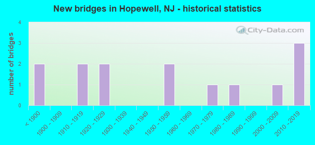
- New bridges - historical statistics
- 2Before 1900
- 21910-1919
- 21920-1929
- 21950-1959
- 11970-1979
- 11980-1989
- 12000-2009
- 32010-2019

- Reconstructed bridges - Historical Statistics
- 11920-1929
- 01930-1939
- 01940-1949
- 01950-1959
- 01960-1969
- 11970-1979
- 01980-1989
- 01990-1999
- 52000-2009
- 12010-2019


- Bridge Condition - Deck
- 33.3%Very good
- 50.0%Good
- 8.3%Satisfactory
- 8.3%Poor

- Bridge Condition - Superstructure
- 15.4%Excellent
- 30.8%Very good
- 30.8%Good
- 23.1%Poor

- Bridge Condition - Substructure
- 15.4%Very good
- 46.2%Good
- 23.1%Satisfactory
- 15.4%Fair

- Bridge Condition - Channel
- 10.0%Very good
- 30.0%Good
- 50.0%Satisfactory
- 10.0%Fair
Find on map >> Show street view
Structure Number: 100WE74, Location: 100 YARDS SW OF NJ 31 (Lat: 40.392450, Lng: -74.834919), Route carried "on" structure: City street , Year Built: 1840, Year Reconstructed: 1920, Status: Posted for load, Structure Length: 1.22m (4.00ft), Average Daily Traffic: 1,238 (year 2021), Average Future Daily Traffic: 1,511 (year 2041), Features Intersected: PETERS BROOK, Facility Carried by Structure: WOODSVILLE ROAD
Minimum Vertical Clearance: 30+ m (98+ ft), Kilometerpoint: 0.000, Lanes on structure: 2, Owner: County Highway Agency, Approaching Roadway Width: 4.9m (16.1ft), Material/Design: Masonry, Design/Construction: Arch - Deck, Number Of Spans In Main Unit: 2, Length of Maximum Span: 5.5m (18.0ft), Curb-To-Curb Width: 7.3m (24.0ft), Out-to-Out Width: 8.2m (26.9ft)
Condition: Superstructure: Poor, Substructure: Fair, Channel: Satisfactory, Operating Rating: 44.5 metric tons, Method Used To Determine Operating Rating: Field evaluation and documented engineering judgment, Inventory Rating: 26.3 metric tons, Method Used To Determine Inventory Rating: Field evaluation and documented engineering judgment, Structural Evaluation: Meets minimum limits, Deck Geometry: Meets minimum limits, Waterway Adequacy: Better than present minimum criteria, Approach Roadway Alignment: Better than present minimum criteria, Bridge Posting: Required (Relationship of Operating Rating to Maximum Legal Load: 0.1 - 9.9% below), Length Of Structure Improvement: 1.22m (4.00ft), Designated Inspection Frequency: Every 24 months, Other Special Inspection Frequency: Every 12 months, Inspection Date: April 2021, Other Special Inspection Date: April 2021, Bridge Improvement Cost: $384,000, Roadway Improvement Cost: $50,000, Total Project Cost: $622,000 ( Estimate for 2021)
Find on map >> Show street view
Structure Number: 1010151, Location: 7.25MI N.OF PENNGTN CRCLE (Lat: 40.392489, Lng: -74.834439), Route carried "on" structure: State highway 31, Year Built: 1927, Year Reconstructed: 2018, Status: Open, Structure Length: 1.43m (4.69ft), Average Daily Traffic: 16,358 (year 2020), Truck Traffic: 7%, Average Future Daily Traffic: 19,631 (year 2040), Design Load: HL 93, Features Intersected: PETERS BROOK
Minimum Vertical Clearance: 30+ m (98+ ft), Kilometerpoint: 21.469, Lanes on structure: 2, Base Highway Network: Yes, Owner: State Highway Agency, Approaching Roadway Width: 12.2m (40.0ft), Skew: 4 degrees, Material/Design: Steel, Design/Construction: Stringer/Multi-beam, Number Of Spans In Main Unit: 1, Length of Maximum Span: 12.8m (42.0ft), Curb-To-Curb Width: 12.2m (40.0ft), Out-to-Out Width: 13.3m (43.6ft)
Condition: Deck: Very good, Superstructure: Excellent, Substructure: Good, Channel: Good, Operating Rating: 96.9 metric tons, Method Used To Determine Operating Rating: Load and Resistance Factor Rating (LRFR) rating reported by rating factor(RF) method using HL-93 loadings, Inventory Rating: 96.9 metric tons, Method Used To Determine Inventory Rating: Load and Resistance Factor Rating (LRFR) rating reported by rating factor(RF) method using HL-93 loadings, Structural Evaluation: Better than present minimum criteria, Deck Geometry: Somewhat better than minimum adequacy, Waterway Adequacy: Equal to present minimum criteria, Approach Roadway Alignment: Equal to present desirable criteria, Length Of Structure Improvement: 1.40m (4.59ft), Designated Inspection Frequency: Every 24 months, Inspection Date: June 2020, Bridge Improvement Cost: $336,000, Roadway Improvement Cost: $50,000, Total Project Cost: $425,000 ( Estimate for 2016), Deck Structure Type: Concrete Precast Panels, Wearing Surface/Protective System: Wearing Surface: Latex Concrete, Deck Protection: Epoxy Coated Reinforcing
Find on map >> Show street view
Structure Number: 1100038, Location: 1.03 mile North of Rt. 31 (Lat: 40.365089, Lng: -74.787031), Route carried "on" structure: County highway 654, Year Built: 2007, Status: Open, Structure Length: 3.54m (11.61ft), Average Daily Traffic: 4,270 (year 2021), Truck Traffic: 3%, Average Future Daily Traffic: 5,210 (year 2041), Design Load: HS 25 or greater, Features Intersected: STONY BROOK, Facility Carried by Structure: PENN-HOPEWELL ROAD
Minimum Vertical Clearance: 30+ m (98+ ft), Kilometerpoint: 1.674, Lanes on structure: 2, Owner: County Highway Agency, Approaching Roadway Width: 14.6m (47.9ft), Skew: 6 degrees, Material/Design: Steel, Design/Construction: Stringer/Multi-beam, Number Of Spans In Main Unit: 1, Length of Maximum Span: 33.2m (108.9ft), Curb or Sidewalk Widths: Left: 0.0m, Right: 1.8m (5.9ft), Curb-To-Curb Width: 14.6m (47.9ft), Out-to-Out Width: 17.3m (56.8ft)
Condition: Deck: Good, Superstructure: Good, Substructure: Fair, Channel: Satisfactory, Operating Rating: 59.9 metric tons, Method Used To Determine Operating Rating: Load Factor (LF), Inventory Rating: 35.4 metric tons, Method Used To Determine Inventory Rating: Load Factor (LF), Structural Evaluation: Somewhat better than minimum adequacy, Deck Geometry: Superior to present desirable criteria, Waterway Adequacy: Equal to present desirable criteria, Approach Roadway Alignment: Equal to present minimum criteria, Designated Inspection Frequency: Every 24 months, Inspection Date: Febuary 2021, Deck Structure Type: Concrete Cast-file-Place, Wearing Surface/Protective System: Wearing Surface: Monolithic Concrete, Deck Protection: Epoxy Coated Reinforcing
Find on map >> Show street view
Structure Number: 1100042, Location: 0.5 MI EAST OF CO. 569 (Lat: 40.392519, Lng: -74.749400), Route carried "on" structure: County highway 518, Year Built: 2019, Status: Open, Structure Length: 1.37m (4.49ft), Average Daily Traffic: 10,433 (year 2021), Truck Traffic: 3%, Average Future Daily Traffic: 12,519 (year 2041), Design Load: HL 93, Features Intersected: BEDEN'S BROOK
Minimum Vertical Clearance: 30+ m (98+ ft), Kilometerpoint: 17.719, Lanes on structure: 2, Owner: County Highway Agency, Approaching Roadway Width: 11.6m (38.1ft), Material/Design: Concrete, Design/Construction: Slab, Number Of Spans In Main Unit: 1, Length of Maximum Span: 11.9m (39.0ft), Curb or Sidewalk Widths: Left: 1.5m (4.9ft), Right: 0.0m, Curb-To-Curb Width: 11.6m (38.1ft), Out-to-Out Width: 13.9m (45.6ft)
Condition: Deck: Good, Superstructure: Good, Substructure: Very good, Channel: Fair, Operating Rating: 46.7 metric tons, Method Used To Determine Operating Rating: Load and Resistance Factor Rating (LRFR) rating reported by rating factor(RF) method using HL-93 loadings, Inventory Rating: 36.0 metric tons, Method Used To Determine Inventory Rating: Load and Resistance Factor Rating (LRFR) rating reported by rating factor(RF) method using HL-93 loadings, Structural Evaluation: Better than present minimum criteria, Deck Geometry: Somewhat better than minimum adequacy, Waterway Adequacy: Better than present minimum criteria, Approach Roadway Alignment: Equal to present desirable criteria, Designated Inspection Frequency: Every 24 months, Inspection Date: July 2021, Bridge Improvement Cost: $269,000, Roadway Improvement Cost: $100,000, Total Project Cost: $641,000 ( Estimate for 2015), Deck Structure Type: Concrete Precast Panels, Wearing Surface/Protective System: Wearing Surface: Other, Deck Protection: Galvanized Reinforcing
Find on map >> Show street view
Structure Number: 1100072, Location: 0.24 MI EAST of RT NJ 31 (Lat: 40.373981, Lng: -74.794000), Route carried "on" structure: Other road , Year Built: 1885, Year Reconstructed: 2011, Status: Closed, Structure Length: 3.11m (10.20ft), Average Daily Traffic: 336 (year 2017), Truck Traffic: 3%, Average Future Daily Traffic: 403 (year 2037), Features Intersected: STONY BROOK, Facility Carried by Structure: MINE ROAD
Minimum Vertical Clearance: 3.75m (12.30ft), Kilometerpoint: 0.000, Lanes on structure: 1, Owner: County Highway Agency, Approaching Roadway Width: 6.1m (20.0ft), Material/Design: Aluminum, Iron, Design/Construction: Truss - Thru, Number Of Spans In Main Unit: 1, Length of Maximum Span: 30.8m (101.0ft), Curb-To-Curb Width: 5.1m (16.7ft), Out-to-Out Width: 5.2m (17.1ft)
Condition: Deck: Good, Superstructure: Poor, Substructure: Satisfactory, Channel: Good, Operating Rating: 7.3 metric tons, Method Used To Determine Operating Rating: Allowable Stress (AS), Inventory Rating: 5.4 metric tons, Method Used To Determine Inventory Rating: Allowable Stress (AS), Waterway Adequacy: Equal to present minimum criteria, Approach Roadway Alignment: Equal to present minimum criteria, Bridge Posting: Required (Relationship of Operating Rating to Maximum Legal Load: > 39.9% below), Length Of Structure Improvement: 3.90m (12.80ft), Designated Inspection Frequency: Every 24 months, Critical Feature Inspection Frequency: Every 24 months, Other Special Inspection Frequency: Every 12 months, Inspection Date: April 2021, Critical Feature Inspection Date: April 2017, Other Special Inspection Date: March 2018, Bridge Improvement Cost: $1,464,000, Roadway Improvement Cost: $200,000, Total Project Cost: $2,434,000 ( Estimate for 2017), Deck Structure Type: Open Grating
Find on map >> Show street view
Structure Number: 1102302, Location: 0.21 mile E of Rt 31 (Lat: 40.383681, Lng: -74.815050), Route carried "on" structure: County highway 518, Year Built: 1959, Year Reconstructed: 2014, Status: Open, Structure Length: 3.69m (12.11ft), Average Daily Traffic: 5,440 (year 2021), Truck Traffic: 4%, Average Future Daily Traffic: 6,635 (year 2041), Design Load: HS 25 or greater, Features Intersected: STONY BROOK
Minimum Vertical Clearance: 30+ m (98+ ft), Kilometerpoint: 11.941, Lanes on structure: 2, Base Highway Network: Yes, Owner: County Highway Agency, Approaching Roadway Width: 12.2m (40.0ft), Skew: 5 degrees, Material/Design: Steel continuous, Design/Construction: Stringer/Multi-beam, Number Of Spans In Main Unit: 2, Length of Maximum Span: 18.0m (59.1ft), Curb or Sidewalk Widths: Left: 0.2m (0.7ft), Right: 0.2m (0.7ft), Curb-To-Curb Width: 12.2m (40.0ft), Out-to-Out Width: 13.4m (44.0ft)
Condition: Deck: Very good, Superstructure: Very good, Substructure: Good, Channel: Satisfactory, Structural Evaluation: Better than present minimum criteria, Deck Geometry: Somewhat better than minimum adequacy, Waterway Adequacy: Equal to present desirable criteria, Approach Roadway Alignment: Equal to present desirable criteria, Designated Inspection Frequency: Every 24 months, Inspection Date: Febuary 2021, Deck Structure Type: Concrete Cast-file-Place, Wearing Surface/Protective System: Wearing Surface: Monolithic Concrete, Deck Protection: Epoxy Coated Reinforcing
Find on map >> Show street view
Structure Number: 1102392, Location: WOODSVILLE-.3MI SE RT 518 (Lat: 40.377231, Lng: -74.825531), Route carried "on" structure: County highway 612, Year Built: 1981, Status: Open, Structure Length: 0.67m (2.20ft), Average Daily Traffic: 1,389 (year 2021), Truck Traffic: 3%, Average Future Daily Traffic: 1,666 (year 2041), Design Load: HS 20+Mod, Features Intersected: WOODSVILLE BROOK, Facility Carried by Structure: MARSHALLS CRNR RD
Minimum Vertical Clearance: 30+ m (98+ ft), Kilometerpoint: 0.756, Lanes on structure: 2, Owner: County Highway Agency, Approaching Roadway Width: 9.1m (29.9ft), Skew: 1 degrees, Material/Design: Concrete, Design/Construction: Culvert, Number Of Spans In Main Unit: 1, Length of Maximum Span: 6.7m (22.0ft), Curb or Sidewalk Widths: Left: 1.7m (5.6ft), Right: 1.6m (5.2ft), Curb-To-Curb Width: 8.0m (26.2ft), Out-to-Out Width: 12.2m (40.0ft)
Condition: Channel: Satisfactory, Culverts: Satisfactory, Operating Rating: 55.3 metric tons, Method Used To Determine Operating Rating: Load Factor (LF), Inventory Rating: 32.7 metric tons, Method Used To Determine Inventory Rating: Load Factor (LF), Structural Evaluation: Equal to present minimum criteria, Deck Geometry: Meets minimum limits, Waterway Adequacy: Better than present minimum criteria, Approach Roadway Alignment: Better than present minimum criteria, Designated Inspection Frequency: Every 24 months, Inspection Date: Febuary 2021
Find on map >> Show street view
Structure Number: 1102393, Location: 450 ft East of US 31 (Lat: 40.383361, Lng: -74.817950), Route carried "on" structure: County highway 518, Year Built: 1959, Year Reconstructed: 2006, Status: Open, Structure Length: 0.85m (2.79ft), Average Daily Traffic: 5,440 (year 2021), Truck Traffic: 4%, Average Future Daily Traffic: 6,635 (year 2041), Design Load: HS 20+Mod, Features Intersected: WOODSVILLE BROOK
Minimum Vertical Clearance: 30+ m (98+ ft), Kilometerpoint: 11.700, Lanes on structure: 2, Base Highway Network: Yes, Owner: County Highway Agency, Approaching Roadway Width: 14.7m (48.2ft), Skew: 1 degrees, Material/Design: Concrete, Design/Construction: Slab, Number Of Spans In Main Unit: 1, Length of Maximum Span: 7.6m (24.9ft), Curb or Sidewalk Widths: Left: 0.0m, Right: 1.4m (4.6ft), Curb-To-Curb Width: 14.7m (48.2ft), Out-to-Out Width: 16.9m (55.4ft)
Condition: Deck: Satisfactory, Superstructure: Good, Substructure: Good, Channel: Very good, Operating Rating: 57.2 metric tons, Method Used To Determine Operating Rating: Load Factor (LF), Inventory Rating: 33.6 metric tons, Method Used To Determine Inventory Rating: Load Factor (LF), Structural Evaluation: Better than present minimum criteria, Deck Geometry: Superior to present desirable criteria, Waterway Adequacy: Superior to present desirable criteria, Approach Roadway Alignment: Equal to present desirable criteria, Designated Inspection Frequency: Every 24 months, Inspection Date: Febuary 2021, Deck Structure Type: Concrete Cast-file-Place, Wearing Surface/Protective System: Wearing Surface: Monolithic Concrete
Find on map >> Show street view
Structure Number: 1102503, Location: 2.32 MI N. OF Clevland Rd (Lat: 40.381250, Lng: -74.752531), Route carried "on" structure: County highway 569, Year Built: 1973, Status: Open, Structure Length: 1.04m (3.41ft), Average Daily Traffic: 6,240 (year 2021), Truck Traffic: 4%, Average Future Daily Traffic: 7,610 (year 2040), Design Load: HS 20, Features Intersected: BEDENS BROOK
Minimum Vertical Clearance: 30+ m (98+ ft), Kilometerpoint: 12.601, Lanes on structure: 2, Base Highway Network: Yes, Owner: County Highway Agency, Approaching Roadway Width: 9.1m (29.9ft), Material/Design: Prestressed concrete, Design/Construction: Box Beam or Girders - Multiple, Number Of Spans In Main Unit: 1, Length of Maximum Span: 9.4m (30.8ft), Curb-To-Curb Width: 7.0m (23.0ft), Out-to-Out Width: 10.1m (33.1ft)
Condition: Deck: Poor, Superstructure: Poor, Substructure: Satisfactory, Channel: Satisfactory, Operating Rating: 29.0 metric tons, Method Used To Determine Operating Rating: Load Factor (LF), Inventory Rating: 17.2 metric tons, Method Used To Determine Inventory Rating: Load Factor (LF), Structural Evaluation: Meets minimum limits, Deck Geometry: High priority of replacement, Waterway Adequacy: Equal to present minimum criteria, Approach Roadway Alignment: Equal to present desirable criteria, Length Of Structure Improvement: 1.22m (4.00ft), Designated Inspection Frequency: Every 24 months, Inspection Date: Febuary 2021, Bridge Improvement Cost: $662,000, Roadway Improvement Cost: $100,000, Total Project Cost: $828,000 ( Estimate for 2021), Deck Structure Type: Concrete Precast Panels, Wearing Surface/Protective System: Wearing Surface: Bituminous
Find on map >> Show street view
Structure Number: 111915, Location: 1.0 MI NORTH OF CR 546 (Lat: 40.318111, Lng: -74.796969), Route carried "on" structure: State highway 31, Year Built: 2018, Status: Open, Structure Length: 3.35m (10.99ft), Average Daily Traffic: 20,584 (year 2020), Truck Traffic: 6%, Average Future Daily Traffic: 24,701 (year 2040), Design Load: HL 93, Features Intersected: TRENTON LINE (CSX RR)
Minimum Vertical Clearance: 30+ m (98+ ft), Kilometerpoint: 11.298, Lanes on structure: 2, Base Highway Network: Yes, Owner: State Highway Agency, Approaching Roadway Width: 15.8m (51.8ft), Skew: 3 degrees, Material/Design: Steel, Design/Construction: Stringer/Multi-beam, Number Of Spans In Main Unit: 1, Length of Maximum Span: 31.7m (104.0ft), Curb or Sidewalk Widths: Left: 1.5m (4.9ft), Right: 1.5m (4.9ft), Curb-To-Curb Width: 15.8m (51.8ft), Out-to-Out Width: 19.7m (64.6ft)
Condition: Deck: Very good, Superstructure: Excellent, Substructure: Very good, Operating Rating: 68.4 metric tons, Method Used To Determine Operating Rating: Load and Resistance Factor Rating (LRFR) rating reported by rating factor(RF) method using HL-93 loadings, Inventory Rating: 52.5 metric tons, Method Used To Determine Inventory Rating: Load and Resistance Factor Rating (LRFR) rating reported by rating factor(RF) method using HL-93 loadings, Structural Evaluation: Equal to present desirable criteria, Deck Geometry: Superior to present desirable criteria, Underclear: Superior to present desirable criteria, Approach Roadway Alignment: Equal to present desirable criteria, Length Of Structure Improvement: 4.63m (15.19ft), Designated Inspection Frequency: Every 24 months, Inspection Date: December 2020, Bridge Improvement Cost: $4,118,000, Roadway Improvement Cost: $618,000, Total Project Cost: $6,419,000 ( Estimate for 2016), Deck Structure Type: Concrete Cast-file-Place, Wearing Surface/Protective System: Wearing Surface: Monolithic Concrete, Deck Protection: Epoxy Coated Reinforcing
Find on map >> Show street view
Structure Number: 1119156, Location: 4.2 MI S OF 31-202 JCT (Lat: 40.382950, Lng: -74.817831), Route carried "on" structure: State highway 31, Year Built: 1929, Year Reconstructed: 2006, Status: Open, Structure Length: 1.16m (3.81ft), Average Daily Traffic: 19,320 (year 2020), Truck Traffic: 7%, Average Future Daily Traffic: 23,574 (year 2040), Design Load: HS 20, Features Intersected: STONY BROOK
Minimum Vertical Clearance: 30.45m (99.90ft), Kilometerpoint: 19.650, Lanes on structure: 4, Base Highway Network: Yes, Owner: State Highway Agency, Approaching Roadway Width: 21.2m (69.6ft), Skew: 22 degrees, Material/Design: Prestressed concrete, Design/Construction: Slab, Number Of Spans In Main Unit: 1, Length of Maximum Span: 10.4m (34.1ft), Curb-To-Curb Width: 21.2m (69.6ft), Out-to-Out Width: 22.4m (73.5ft)
Condition: Deck: Good, Superstructure: Very good, Substructure: Good, Channel: Good, Inventory Rating: 56.2 metric tons, Method Used To Determine Inventory Rating: Load Factor (LF), Structural Evaluation: Better than present minimum criteria, Deck Geometry: Superior to present desirable criteria, Waterway Adequacy: Equal to present minimum criteria, Approach Roadway Alignment: Equal to present desirable criteria, Designated Inspection Frequency: Every 24 months, Inspection Date: May 2020, Deck Structure Type: Concrete Cast-file-Place, Wearing Surface/Protective System: Wearing Surface: Monolithic Concrete
Find on map >> Show street view
Structure Number: 115016, Location: 2.6MI OF NW I295&NJ31 JCT (Lat: 40.327500, Lng: -74.796350), Route carried "on" structure: City street , Year Built: 1914, Year Reconstructed: 1975, Status: Open, Structure Length: 2.38m (7.81ft), Average Daily Traffic: 6,042 (year 2021), Truck Traffic: 3%, Average Future Daily Traffic: 7,372 (year 2041), Design Load: HS 20+Mod, Features Intersected: TRENTON LINE (CSXT), Facility Carried by Structure: W. DELAWARE AVENUE
Minimum Vertical Clearance: 30+ m (98+ ft), Kilometerpoint: 0.628, Lanes on structure: 2, Maintenance Responsibility: State Highway Agency, Approaching Roadway Width: 9.1m (29.9ft), Skew: 1 degrees, Material/Design: Wood or Timber, Design/Construction: Stringer/Multi-beam, Number Of Spans In Main Unit: 3, Length of Maximum Span: 10.1m (33.1ft), Curb or Sidewalk Widths: Left: 1.4m (4.6ft), Right: 1.4m (4.6ft), Curb-To-Curb Width: 9.0m (29.5ft), Out-to-Out Width: 12.3m (40.4ft)
Condition: Deck: Good, Superstructure: Good, Substructure: Satisfactory, Operating Rating: 31.8 metric tons, Method Used To Determine Operating Rating: Allowable Stress (AS), Inventory Rating: 20.0 metric tons, Method Used To Determine Inventory Rating: Allowable Stress (AS), Structural Evaluation: Somewhat better than minimum adequacy, Deck Geometry: High priority of replacement, Underclear: Meets minimum limits, Approach Roadway Alignment: Equal to present minimum criteria, Length Of Structure Improvement: 2.38m (7.81ft), Designated Inspection Frequency: Every 24 months, Inspection Date: October 2021, Bridge Improvement Cost: $87,000, Roadway Improvement Cost: $53,000, Total Project Cost: $277,000 ( Estimate for 2021), Deck Structure Type: Wood or Timber, Wearing Surface/Protective System: Wearing Surface: Bituminous
Find on map >> Show street view
Structure Number: 1150162, Location: 0.2 Miles North of CR 654 (Lat: 40.383150, Lng: -74.780450), Route carried "on" structure: City street , Year Built: 2011, Status: Open, Structure Length: 2.16m (7.09ft), Average Daily Traffic: 1,205 (year 2021), Truck Traffic: 1%, Average Future Daily Traffic: 1,470 (year 2041), Design Load: HL 93, Features Intersected: TRENTON LINE (CSX), Facility Carried by Structure: VAN DYKE ROAD
Minimum Vertical Clearance: 30+ m (98+ ft), Kilometerpoint: 0.000, Lanes on structure: 2, Owner: County Highway Agency, Approaching Roadway Width: 7.3m (24.0ft), Material/Design: Steel, Design/Construction: Stringer/Multi-beam, Number Of Spans In Main Unit: 1, Length of Maximum Span: 19.2m (63.0ft), Curb-To-Curb Width: 7.3m (24.0ft), Out-to-Out Width: 8.4m (27.6ft)
Condition: Deck: Good, Superstructure: Very good, Substructure: Good, Operating Rating: 82.0 metric tons, Method Used To Determine Operating Rating: Load and Resistance Factor Rating (LRFR) rating reported by rating factor(RF) method using HL-93 loadings, Inventory Rating: 63.2 metric tons, Method Used To Determine Inventory Rating: Load and Resistance Factor Rating (LRFR) rating reported by rating factor(RF) method using HL-93 loadings, Structural Evaluation: Better than present minimum criteria, Deck Geometry: Meets minimum limits, Underclear: Equal to present desirable criteria, Approach Roadway Alignment: Meets minimum limits, Designated Inspection Frequency: Every 24 months, Inspection Date: March 2021, Deck Structure Type: Concrete Precast Panels, Wearing Surface/Protective System: Deck Protection: Epoxy Coated Reinforcing
Find on map >> Show street view
Structure Number: 1150163, Location: 0.2 MI NORTH OF CR 518 (Lat: 40.391400, Lng: -74.763589), Route carried "on" structure: City street , Year Built: 1918, Year Reconstructed: 2011, Status: Open, Structure Length: 2.16m (7.09ft), Average Daily Traffic: 5,199 (year 2021), Truck Traffic: 3%, Average Future Daily Traffic: 6,238 (year 2041), Design Load: HL 93, Features Intersected: CSXT TRENTON LINE, Facility Carried by Structure: GREENWOOD AVENUE
Minimum Vertical Clearance: 30+ m (98+ ft), Kilometerpoint: 1.159, Lanes on structure: 2, Owner: County Highway Agency, Approaching Roadway Width: 7.3m (24.0ft), Material/Design: Steel, Design/Construction: Stringer/Multi-beam, Number Of Spans In Main Unit: 1, Length of Maximum Span: 19.5m (64.0ft), Curb or Sidewalk Widths: Left: 1.9m (6.2ft), Right: 2.4m (7.9ft), Curb-To-Curb Width: 7.4m (24.3ft), Out-to-Out Width: 13.0m (42.7ft)
Condition: Deck: Very good, Superstructure: Very good, Substructure: Good, Operating Rating: 57.0 metric tons, Method Used To Determine Operating Rating: Load and Resistance Factor Rating (LRFR) rating reported by rating factor(RF) method using HL-93 loadings, Inventory Rating: 44.1 metric tons, Method Used To Determine Inventory Rating: Load and Resistance Factor Rating (LRFR) rating reported by rating factor(RF) method using HL-93 loadings, Structural Evaluation: Better than present minimum criteria, Deck Geometry: High priority of replacement, Underclear: Somewhat better than minimum adequacy, Approach Roadway Alignment: Meets minimum limits, Designated Inspection Frequency: Every 24 months, Inspection Date: March 2021, Deck Structure Type: Concrete Precast Panels, Wearing Surface/Protective System: Wearing Surface: Monolithic Concrete, Deck Protection: Epoxy Coated Reinforcing