Bridge Statistics for Hopewell, Pennsylvania (PA)
Condition, Traffic, Stress, Structural Evaluation, Project Costs
- National Bridge Inventory (NBI) Statistics
- 20Number of bridges
- 171ft / 51.9mTotal length
- $9,901,000Total costs
- 33,949Total average daily traffic
- 2,211Total average daily truck traffic
- 50,364Total future (year 2030) average daily traffic
- National Bridge Inventory (NBI) Registered Bridges for Hopewell
- No street view available for this location
- New bridges - historical statistics
- 2Before 1900
- 51930-1939
- 51950-1959
- 11960-1969
- 11980-1989
- 22000-2009
- 32010-2019
- 12020-2022
- Reconstructed bridges - Historical Statistics
- 11970-1979
- 21980-1989
- 11990-1999
- 32000-2009
- Bridge Condition - Deck
- 6.3%Excellent
- 18.8%Very good
- 25.0%Good
- 25.0%Satisfactory
- 6.3%Fair
- 12.5%Poor
- 6.3%Serious
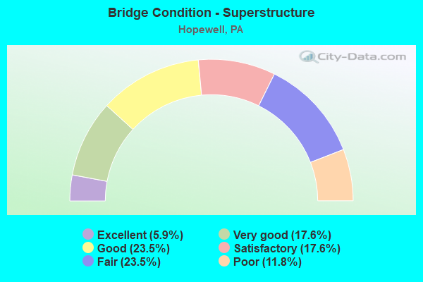
- Bridge Condition - Superstructure
- 5.9%Excellent
- 17.6%Very good
- 23.5%Good
- 17.6%Satisfactory
- 23.5%Fair
- 11.8%Poor
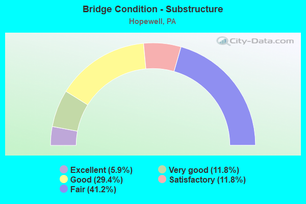
- Bridge Condition - Substructure
- 5.9%Excellent
- 11.8%Very good
- 29.4%Good
- 11.8%Satisfactory
- 41.2%Fair
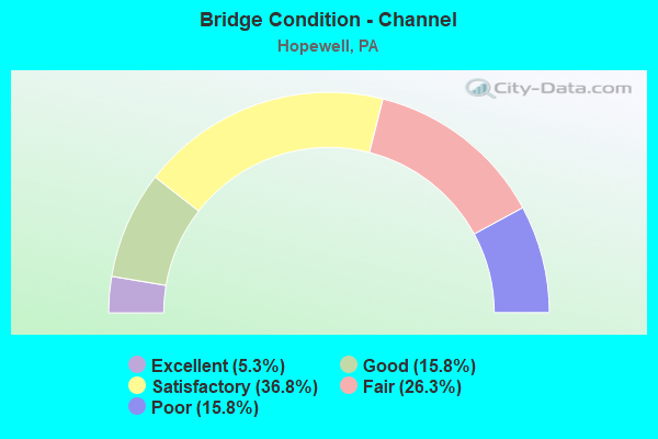
- Bridge Condition - Channel
- 5.3%Excellent
- 15.8%Good
- 36.8%Satisfactory
- 26.3%Fair
- 15.8%Poor
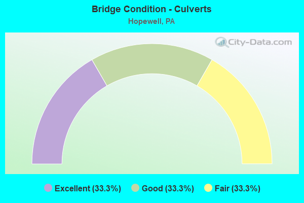
- Bridge Condition - Culverts
- 33.3%Excellent
- 33.3%Good
- 33.3%Fair
Find on map >> Show street view
Structure Number: 1924, Location: 0.3 MI. N.W. OF SR 4002 (Lat: 40.498322, Lng: -79.978942), Route carried "on" structure: State highway , Year Built: 1931, Status: Open, Structure Length: 1.16m (3.81ft), Average Daily Traffic: 11,703 (year 2021), Truck Traffic: 6%, Average Future Daily Traffic: 17,328 (year 2032), Features Intersected: GIRTYS RUN, Facility Carried by Structure: BABCOCK BLVD
Minimum Vertical Clearance: 30+ m (98+ ft), Kilometerpoint: 3.064, Lanes on structure: 2, Base Highway Network: Yes, Owner: State Highway Agency, Approaching Roadway Width: 12.2m (40.0ft), Skew: 4 degrees, Material/Design: Concrete, Design/Construction: Frame, Number Of Spans In Main Unit: 1, Length of Maximum Span: 10.7m (35.1ft), Curb or Sidewalk Widths: Left: 1.2m (3.9ft), Right: 1.7m (5.6ft), Curb-To-Curb Width: 9.6m (31.5ft), Out-to-Out Width: 11.6m (38.1ft)
Condition: Superstructure: Fair, Substructure: Fair, Channel: Fair, Operating Rating: 49.0 metric tons, Method Used To Determine Operating Rating: Field evaluation and documented engineering judgment, Inventory Rating: 32.7 metric tons, Method Used To Determine Inventory Rating: Field evaluation and documented engineering judgment, Structural Evaluation: Somewhat better than minimum adequacy, Deck Geometry: High priority of corrective action, Waterway Adequacy: Equal to present minimum criteria, Approach Roadway Alignment: Equal to present desirable criteria, Length Of Structure Improvement: 1.20m (3.94ft), Designated Inspection Frequency: Every 24 months, Inspection Date: Febuary 2020, Bridge Improvement Cost: $8,000, Roadway Improvement Cost: $25,000, Total Project Cost: $109,000
Find on map >> Show street view
Structure Number: 3727, Location: 200' S.W. OF TWP.RD.370 (Lat: 40.532283, Lng: -80.434483), Route carried "on" structure: State highway , Year Built: 1934, Year Reconstructed: 2009, Status: Open, Structure Length: 0.85m (2.79ft), Average Daily Traffic: 285 (year 2022), Truck Traffic: 9%, Average Future Daily Traffic: 513 (year 2032), Design Load: HS 20, Features Intersected: LITTLE SERVICE RUN, Facility Carried by Structure: KENDALL HARSHAV RD
Minimum Vertical Clearance: 30+ m (98+ ft), Kilometerpoint: 9.112, Lanes on structure: 2, Owner: State Highway Agency, Approaching Roadway Width: 8.5m (27.9ft), Skew: 3 degrees, Material/Design: Concrete, Design/Construction: Slab, Number Of Spans In Main Unit: 1, Length of Maximum Span: 7.0m (23.0ft), Curb-To-Curb Width: 7.9m (25.9ft), Out-to-Out Width: 10.4m (34.1ft)
Condition: Deck: Good, Superstructure: Good, Substructure: Good, Channel: Satisfactory, Operating Rating: 74.4 metric tons, Method Used To Determine Operating Rating: Load Factor (LF), Inventory Rating: 44.5 metric tons, Method Used To Determine Inventory Rating: Load Factor (LF), Structural Evaluation: Better than present minimum criteria, Deck Geometry: Somewhat better than minimum adequacy, Waterway Adequacy: Better than present minimum criteria, Approach Roadway Alignment: Better than present minimum criteria, Length Of Structure Improvement: 0.90m (2.95ft), Designated Inspection Frequency: Every 24 months, Inspection Date: April 2021, Bridge Improvement Cost: $10,000, Roadway Improvement Cost: $30,000, Total Project Cost: $137,000, Deck Structure Type: Concrete Cast-file-Place, Wearing Surface/Protective System: Wearing Surface: Monolithic Concrete, Deck Protection: Epoxy Coated Reinforcing
Find on map >> Show street view
Structure Number: 4139, Location: 0.6 MILE SOUTH OF TR 26 (Lat: 40.131564, Lng: -78.266361), Route carried "on" structure: State highway 915, Year Built: 1959, Year Reconstructed: 2009, Status: Open, Structure Length: 2.99m (9.81ft), Average Daily Traffic: 767 (year 2020), Truck Traffic: 6%, Average Future Daily Traffic: 1,006 (year 2032), Design Load: HL 93, Features Intersected: SANDY RUN
Minimum Vertical Clearance: 30+ m (98+ ft), Kilometerpoint: 9.024, Lanes on structure: 2, Owner: State Highway Agency, Approaching Roadway Width: 9.1m (29.9ft), Skew: 6 degrees, Material/Design: Prestressed concrete, Design/Construction: Box Beam or Girders - Single/Spread, Number Of Spans In Main Unit: 2, Length of Maximum Span: 14.0m (45.9ft), Curb or Sidewalk Widths: Left: 0.2m (0.7ft), Right: 0.2m (0.7ft), Curb-To-Curb Width: 9.8m (32.2ft), Out-to-Out Width: 10.8m (35.4ft)
Condition: Deck: Good, Superstructure: Very good, Substructure: Fair, Channel: Fair, Operating Rating: 61.7 metric tons, Method Used To Determine Operating Rating: Load and Resistance Factor (LRFR), Inventory Rating: 43.5 metric tons, Method Used To Determine Inventory Rating: Load and Resistance Factor (LRFR), Structural Evaluation: Somewhat better than minimum adequacy, Deck Geometry: Equal to present minimum criteria, Waterway Adequacy: Equal to present desirable criteria, Approach Roadway Alignment: Equal to present desirable criteria, Length Of Structure Improvement: 3.70m (12.14ft), Designated Inspection Frequency: Every 24 months, Inspection Date: March 2021, Bridge Improvement Cost: $89,000, Roadway Improvement Cost: $264,000, Total Project Cost: $1,206,000, Deck Structure Type: Concrete Cast-file-Place, Wearing Surface/Protective System: Wearing Surface: Epoxy Overlay, Deck Protection: Epoxy Coated Reinforcing
Find on map >> Show street view
Structure Number: 4198, Location: 1.3 MILE EAST OF CYPHER (Lat: 40.091508, Lng: -78.293939), Route carried "on" structure: State highway , Year Built: 1937, Year Reconstructed: 2004, Status: Open, Structure Length: 7.22m (23.69ft), Average Daily Traffic: 158 (year 2022), Truck Traffic: 11%, Average Future Daily Traffic: 399 (year 2032), Design Load: HS 25 or greater, Features Intersected: RAYSTOWN BR.JUNIATA RIV., Facility Carried by Structure: SR 1020
Minimum Vertical Clearance: 30+ m (98+ ft), Kilometerpoint: 2.704, Lanes on structure: 2, Owner: State Highway Agency, Approaching Roadway Width: 6.4m (21.0ft), Material/Design: Steel, Design/Construction: Truss - Thru, Number Of Spans In Main Unit: 2, Length of Maximum Span: 35.4m (116.1ft), Curb or Sidewalk Widths: Left: 0.2m (0.7ft), Right: 0.2m (0.7ft), Curb-To-Curb Width: 6.1m (20.0ft), Out-to-Out Width: 6.9m (22.6ft)
Condition: Deck: Satisfactory, Superstructure: Satisfactory, Substructure: Good, Channel: Satisfactory, Operating Rating: 69.9 metric tons, Method Used To Determine Operating Rating: Allowable Stress (AS), Inventory Rating: 45.4 metric tons, Method Used To Determine Inventory Rating: Allowable Stress (AS), Structural Evaluation: Equal to present minimum criteria, Deck Geometry: Meets minimum limits, Waterway Adequacy: Better than present minimum criteria, Approach Roadway Alignment: Meets minimum limits, Length Of Structure Improvement: 8.99m (29.49ft), Designated Inspection Frequency: Every 24 months, Critical Feature Inspection Frequency: Every 24 months, Inspection Date: April 2020, Critical Feature Inspection Date: April 2020, Bridge Improvement Cost: $219,000, Roadway Improvement Cost: $644,000, Total Project Cost: $2,953,000, Deck Structure Type: Concrete Cast-file-Place, Wearing Surface/Protective System: Wearing Surface: Monolithic Concrete, Deck Protection: Epoxy Coated Reinforcing
Find on map >> Show street view
Structure Number: 42, Location: 2.8 MILE EAST OF SR 1009 (Lat: 40.077750, Lng: -78.286247), Route carried "on" structure: State highway , Year Built: 1950, Status: Open, Structure Length: 1.77m (5.81ft), Average Daily Traffic: 158 (year 2022), Truck Traffic: 11%, Average Future Daily Traffic: 399 (year 2032), Design Load: HS 20, Features Intersected: SHERMAN VALLEY RUN, Facility Carried by Structure: SR 1020
Minimum Vertical Clearance: 30+ m (98+ ft), Kilometerpoint: 4.857, Lanes on structure: 2, Owner: State Highway Agency, Approaching Roadway Width: 6.1m (20.0ft), Skew: 4 degrees, Material/Design: Steel, Design/Construction: Stringer/Multi-beam, Number Of Spans In Main Unit: 1, Length of Maximum Span: 16.5m (54.1ft), Curb or Sidewalk Widths: Left: 0.2m (0.7ft), Right: 0.2m (0.7ft), Curb-To-Curb Width: 6.7m (22.0ft), Out-to-Out Width: 7.3m (24.0ft)
Condition: Deck: Fair, Superstructure: Fair, Substructure: Fair, Channel: Poor, Operating Rating: 58.1 metric tons, Method Used To Determine Operating Rating: Load Factor (LF), Inventory Rating: 34.5 metric tons, Method Used To Determine Inventory Rating: Load Factor (LF), Structural Evaluation: Somewhat better than minimum adequacy, Deck Geometry: Meets minimum limits, Waterway Adequacy: Better than present minimum criteria, Approach Roadway Alignment: Equal to present desirable criteria, Length Of Structure Improvement: 2.10m (6.89ft), Designated Inspection Frequency: Every 24 months, Inspection Date: March 2021, Bridge Improvement Cost: $63,000, Roadway Improvement Cost: $264,000, Total Project Cost: $845,000, Deck Structure Type: Closed Grating, Wearing Surface/Protective System: Wearing Surface: Bituminous, Membrane: Preformed Fabric
Find on map >> Show street view
Structure Number: 4202, Location: 3.0 MILE EAST OF SR 1009 (Lat: 40.077064, Lng: -78.283442), Route carried "on" structure: State highway , Year Built: 1950, Status: Open, Structure Length: 1.37m (4.49ft), Average Daily Traffic: 158 (year 2022), Truck Traffic: 11%, Average Future Daily Traffic: 399 (year 2032), Design Load: H 20, Features Intersected: SHERMAN VALLEY RUN, Facility Carried by Structure: SR 1020
Minimum Vertical Clearance: 30+ m (98+ ft), Kilometerpoint: 5.259, Lanes on structure: 2, Owner: State Highway Agency, Approaching Roadway Width: 6.4m (21.0ft), Skew: 4 degrees, Material/Design: Concrete, Design/Construction: Tee Beam, Number Of Spans In Main Unit: 1, Length of Maximum Span: 12.8m (42.0ft), Curb or Sidewalk Widths: Left: 0.3m (1.0ft), Right: 0.3m (1.0ft), Curb-To-Curb Width: 7.3m (24.0ft), Out-to-Out Width: 8.4m (27.6ft)
Condition: Deck: Satisfactory, Superstructure: Fair, Substructure: Fair, Channel: Poor, Operating Rating: 47.2 metric tons, Method Used To Determine Operating Rating: Load Factor (LF), Inventory Rating: 28.1 metric tons, Method Used To Determine Inventory Rating: Load Factor (LF), Structural Evaluation: Somewhat better than minimum adequacy, Deck Geometry: Somewhat better than minimum adequacy, Waterway Adequacy: Better than present minimum criteria, Approach Roadway Alignment: Better than present minimum criteria, Length Of Structure Improvement: 1.70m (5.58ft), Designated Inspection Frequency: Every 24 months, Inspection Date: March 2021, Bridge Improvement Cost: $56,000, Roadway Improvement Cost: $264,000, Total Project Cost: $750,000, Deck Structure Type: Concrete Cast-file-Place, Wearing Surface/Protective System: Wearing Surface: Bituminous, Membrane: Preformed Fabric
Find on map >> Show street view
Structure Number: 4495, Location: 1 MI.NW.OF HOPEWELL (Lat: 40.139589, Lng: -78.275881), Route carried "on" structure: City street , Year Built: 1930, Year Reconstructed: 1977, Status: Posted for load, Structure Length: 3.87m (12.70ft), Average Daily Traffic: 62 (year 2021), Truck Traffic: 1%, Average Future Daily Traffic: 87 (year 2041), Design Load: H 15, Features Intersected: YELLOW CREEK, Facility Carried by Structure: T526,Polecat Hlw R
Minimum Vertical Clearance: 30+ m (98+ ft), Kilometerpoint: 0.000, Lanes on structure: 2, Owner: County Highway Agency, Approaching Roadway Width: 4.6m (15.1ft), Material/Design: Steel, Design/Construction: Stringer/Multi-beam, Number Of Spans In Main Unit: 2, Length of Maximum Span: 18.6m (61.0ft), Curb-To-Curb Width: 6.0m (19.7ft), Out-to-Out Width: 6.2m (20.3ft)
Condition: Deck: Poor, Superstructure: Fair, Substructure: Good, Channel: Good, Operating Rating: 23.6 metric tons, Method Used To Determine Operating Rating: Load Factor (LF), Inventory Rating: 13.6 metric tons, Method Used To Determine Inventory Rating: Load Factor (LF), Structural Evaluation: Meets minimum limits, Deck Geometry: Meets minimum limits, Waterway Adequacy: Better than present minimum criteria, Approach Roadway Alignment: Equal to present desirable criteria, Bridge Posting: Required (Relationship of Operating Rating to Maximum Legal Load: > 39.9% below), Length Of Structure Improvement: 4.70m (15.42ft), Designated Inspection Frequency: Every 24 months, Other Special Inspection Frequency: Every 12 months, Inspection Date: June 2021, Other Special Inspection Date: June 2021, Bridge Improvement Cost: $25,000, Roadway Improvement Cost: $73,000, Total Project Cost: $335,000, Deck Structure Type: Wood or Timber, Wearing Surface/Protective System: Wearing Surface: Bituminous
Find on map >> Show street view
Structure Number: 4496, Location: 1 MI.SE.OF YELLOW CREEK (Lat: 40.124286, Lng: -78.317133), Route carried "on" structure: City street , Year Built: 1884, Year Reconstructed: 1994, Status: Posted for load, Structure Length: 3.02m (9.91ft), Average Daily Traffic: 45 (year 2021), Average Future Daily Traffic: 48 (year 2041), Design Load: H 10, Features Intersected: YELLOW CREEK, Facility Carried by Structure: T539,St Paul Ch Rd
Minimum Vertical Clearance: 2.97m (9.74ft), Kilometerpoint: 0.000, Lanes on structure: 1, Owner: County Highway Agency, Approaching Roadway Width: 3.4m (11.2ft), Material/Design: Steel, Design/Construction: Stringer/Multi-beam, Number Of Spans In Main Unit: 1, Length of Maximum Span: 28.3m (92.8ft), Curb or Sidewalk Widths: Left: 0.2m (0.7ft), Right: 0.2m (0.7ft), Curb-To-Curb Width: 3.2m (10.5ft), Out-to-Out Width: 3.9m (12.8ft)
Condition: Deck: Good, Superstructure: Good, Substructure: Good, Channel: Fair, Operating Rating: 35.4 metric tons, Method Used To Determine Operating Rating: Load Factor (LF), Inventory Rating: 22.7 metric tons, Method Used To Determine Inventory Rating: Load Factor (LF), Structural Evaluation: Equal to present minimum criteria, Deck Geometry: High priority of replacement, Waterway Adequacy: Equal to present desirable criteria, Approach Roadway Alignment: Meets minimum limits, Bridge Posting: Required (Relationship of Operating Rating to Maximum Legal Load: 0.1 - 9.9% below), Length Of Structure Improvement: 3.80m (12.47ft), Designated Inspection Frequency: Every 24 months, Other Special Inspection Frequency: Every 12 months, Inspection Date: March 2021, Other Special Inspection Date: March 2021, Bridge Improvement Cost: $92,000, Roadway Improvement Cost: $272,000, Total Project Cost: $1,247,000, Deck Structure Type: Wood or Timber, Wearing Surface/Protective System: Wearing Surface: Wood or Timber
Find on map >> Show street view
Structure Number: 4497, Location: 3 MI.SE.OF LOYSBURG (Lat: 40.135889, Lng: -78.328292), Route carried "on" structure: City street , Year Built: 1980, Status: Posted for load, Structure Length: 2.41m (7.91ft), Average Daily Traffic: 60 (year 2021), Truck Traffic: 1%, Average Future Daily Traffic: 45 (year 2041), Design Load: HS 20, Features Intersected: YELLOW CREEK, Facility Carried by Structure: T557,Yellow Crk Dr
Minimum Vertical Clearance: 30+ m (98+ ft), Kilometerpoint: 0.000, Lanes on structure: 2, Owner: County Highway Agency, Approaching Roadway Width: 4.6m (15.1ft), Material/Design: Steel, Design/Construction: Stringer/Multi-beam, Number Of Spans In Main Unit: 1, Length of Maximum Span: 23.5m (77.1ft), Curb-To-Curb Width: 6.2m (20.3ft), Out-to-Out Width: 6.4m (21.0ft)
Condition: Deck: Serious, Superstructure: Poor, Substructure: Satisfactory, Channel: Good, Operating Rating: 23.6 metric tons, Method Used To Determine Operating Rating: Allowable Stress (AS), Inventory Rating: 17.2 metric tons, Method Used To Determine Inventory Rating: Allowable Stress (AS), Structural Evaluation: Meets minimum limits, Deck Geometry: Somewhat better than minimum adequacy, Waterway Adequacy: Better than present minimum criteria, Approach Roadway Alignment: Meets minimum limits, Bridge Posting: Required (Relationship of Operating Rating to Maximum Legal Load: 30.0 - 39.9% below), Length Of Structure Improvement: 3.10m (10.17ft), Designated Inspection Frequency: Every 24 months, Other Special Inspection Frequency: Every 12 months, Inspection Date: June 2021, Other Special Inspection Date: June 2021, Bridge Improvement Cost: $22,000, Roadway Improvement Cost: $64,000, Total Project Cost: $292,000, Deck Structure Type: Wood or Timber, Wearing Surface/Protective System: Wearing Surface: Bituminous
Find on map >> Show street view
Structure Number: 4498, Location: .5 MI.NW.HOPEWELL (Lat: 40.138100, Lng: -78.271297), Route carried "on" structure: City street , Year Built: 1889, Year Reconstructed: 2011, Status: Posted for load, Structure Length: 3.17m (10.40ft), Average Daily Traffic: 20 (year 2021), Truck Traffic: 1%, Average Future Daily Traffic: 25 (year 2041), Design Load: H 10, Features Intersected: YELLOW CREEK, Facility Carried by Structure: T-655, Langdon Dr
Minimum Vertical Clearance: 4.11m (13.48ft), Kilometerpoint: 0.000, Lanes on structure: 1, Owner: County Highway Agency, Approaching Roadway Width: 2.7m (8.9ft), Material/Design: Steel, Design/Construction: Truss - Thru, Number Of Spans In Main Unit: 1, Length of Maximum Span: 31.1m (102.0ft), Curb-To-Curb Width: 3.5m (11.5ft), Out-to-Out Width: 4.0m (13.1ft)
Condition: Deck: Very good, Superstructure: Good, Substructure: Fair, Channel: Satisfactory, Operating Rating: 20.0 metric tons, Method Used To Determine Operating Rating: Load Factor (LF), Inventory Rating: 14.5 metric tons, Method Used To Determine Inventory Rating: Load Factor (LF), Structural Evaluation: Meets minimum limits, Deck Geometry: High priority of replacement, Waterway Adequacy: Equal to present desirable criteria, Approach Roadway Alignment: Meets minimum limits, Bridge Posting: Required (Relationship of Operating Rating to Maximum Legal Load: > 39.9% below), Length Of Structure Improvement: 4.00m (13.12ft), Designated Inspection Frequency: Every 24 months, Critical Feature Inspection Frequency: Every 24 months, Other Special Inspection Frequency: Every 12 months, Inspection Date: August 2020, Critical Feature Inspection Date: August 2021, Other Special Inspection Date: August 2021, Bridge Improvement Cost: $96,000, Roadway Improvement Cost: $283,000, Total Project Cost: $1,297,000, Deck Structure Type: Open Grating
Find on map >> Show street view
Structure Number: 19226, Location: DIAMONDVILLE NO.1 (Lat: 40.662947, Lng: -78.968894), Route carried "on" structure: State highway , Year Built: 1935, Status: Open, Structure Length: 2.62m (8.60ft), Average Daily Traffic: 437 (year 2022), Truck Traffic: 6%, Average Future Daily Traffic: 515 (year 2032), Design Load: H 20, Features Intersected: TWO LICK CREEK, Facility Carried by Structure: SR1012
Minimum Vertical Clearance: 30+ m (98+ ft), Kilometerpoint: 14.809, Lanes on structure: 2, Owner: State Highway Agency, Approaching Roadway Width: 5.5m (18.0ft), Material/Design: Concrete, Design/Construction: Tee Beam, Number Of Spans In Main Unit: 2, Length of Maximum Span: 12.8m (42.0ft), Curb or Sidewalk Widths: Left: 0.2m (0.7ft), Right: 0.2m (0.7ft), Curb-To-Curb Width: 7.1m (23.3ft), Out-to-Out Width: 7.9m (25.9ft)
Condition: Deck: Poor, Superstructure: Poor, Substructure: Fair, Channel: Fair, Operating Rating: 53.5 metric tons, Method Used To Determine Operating Rating: Load Factor (LF), Inventory Rating: 31.8 metric tons, Method Used To Determine Inventory Rating: Load Factor (LF), Structural Evaluation: Meets minimum limits, Deck Geometry: Meets minimum limits, Waterway Adequacy: Better than present minimum criteria, Approach Roadway Alignment: Somewhat better than minimum adequacy, Length Of Structure Improvement: 2.60m (8.53ft), Designated Inspection Frequency: Every 24 months, Inspection Date: August 2020, Bridge Improvement Cost: $25,000, Roadway Improvement Cost: $72,000, Total Project Cost: $332,000, Deck Structure Type: Concrete Cast-file-Place, Wearing Surface/Protective System: Wearing Surface: Bituminous
Find on map >> Show street view
Structure Number: 28275, Location: GULPH MILLS INTERC.34K04 (Lat: 40.067781, Lng: -75.343419), Route carried "on" structure: Ramp State highway , Year Built: 1950, Status: Open, Structure Length: 0.85m (2.79ft), Average Daily Traffic: 11,094 (year 2022), Truck Traffic: 7%, Average Future Daily Traffic: 17,965 (year 2032), Design Load: HS 20, Features Intersected: GULPH CREEK / 3367-F10, Facility Carried by Structure: RAMPS B & C OFF
Minimum Vertical Clearance: 30+ m (98+ ft), Kilometerpoint: 0.000, Lanes on structure: 2, Base Highway Network: Yes, Owner: State Highway Agency, Approaching Roadway Width: 11.6m (38.1ft), Skew: 21 degrees, Material/Design: Concrete, Design/Construction: Culvert, Number Of Spans In Main Unit: 1, Length of Maximum Span: 7.6m (24.9ft)
Condition: Channel: Poor, Culverts: Fair, Operating Rating: 66.2 metric tons, Method Used To Determine Operating Rating: Field evaluation and documented engineering judgment, Inventory Rating: 32.7 metric tons, Method Used To Determine Inventory Rating: Field evaluation and documented engineering judgment, Structural Evaluation: Somewhat better than minimum adequacy, Waterway Adequacy: Superior to present desirable criteria, Approach Roadway Alignment: Equal to present desirable criteria, Length Of Structure Improvement: 1.50m (4.92ft), Designated Inspection Frequency: Every 24 months, Inspection Date: August 2021
Find on map >> Show street view
Structure Number: 31031, Location: I-81 RAMP M OVER PA 309 (Lat: 40.881836, Lng: -76.001567), Route carried "on" structure: Ramp State highway , Year Built: 1967, Year Reconstructed: 1987, Status: Open, Structure Length: 4.57m (14.99ft), Average Daily Traffic: 4,344 (year 2021), Truck Traffic: 7%, Average Future Daily Traffic: 4,829 (year 2032), Design Load: HL 93, Features Intersected: PA 309, Facility Carried by Structure: SR 8017 (RAMP M)
Minimum Vertical Clearance: 30+ m (98+ ft), Kilometerpoint: 0.000, Lanes on structure: 4, Lanes under structure: 10, Base Highway Network: Yes, Owner: State Highway Agency, Approaching Roadway Width: 15.5m (50.9ft), Skew: 30 degrees, Material/Design: Prestressed concrete, Design/Construction: Stringer/Multi-beam, Number Of Spans In Main Unit: 3, Length of Maximum Span: 24.1m (79.1ft), Curb-To-Curb Width: 14.5m (47.6ft), Out-to-Out Width: 16.3m (53.5ft)
Condition: Deck: Good, Superstructure: Good, Substructure: Satisfactory, Operating Rating: 49.9 metric tons, Method Used To Determine Operating Rating: Assigned ratings based on Load and Resistance Factor Design (LRFD) reported in metric tons, Inventory Rating: 23.6 metric tons, Method Used To Determine Inventory Rating: Assigned ratings based on Load and Resistance Factor Design (LRFD) reported in metric tons, Structural Evaluation: Somewhat better than minimum adequacy, Deck Geometry: High priority of replacement, Underclear: High priority of corrective action, Approach Roadway Alignment: Equal to present desirable criteria, Length Of Structure Improvement: 5.50m (18.04ft), Designated Inspection Frequency: Every 24 months, Inspection Date: January 2020, Bridge Improvement Cost: $21,000, Roadway Improvement Cost: $63,000, Total Project Cost: $287,000, Deck Structure Type: Concrete Cast-file-Place, Wearing Surface/Protective System: Wearing Surface: Latex Concrete
Find on map >> Show street view
Structure Number: 33009, Location: 0.5 MI SW OF MORRIS RUN (Lat: 41.662639, Lng: -77.039597), Route carried "on" structure: State highway , Year Built: 1959, Status: Open, Structure Length: 1.16m (3.81ft), Average Daily Traffic: 974 (year 2022), Truck Traffic: 5%, Average Future Daily Traffic: 1,265 (year 2032), Features Intersected: OVER MORRIS RUN, Facility Carried by Structure: SR 2014
Minimum Vertical Clearance: 30+ m (98+ ft), Kilometerpoint: 2.068, Lanes on structure: 2, Owner: State Highway Agency, Approaching Roadway Width: 6.7m (22.0ft), Skew: 4 degrees, Material/Design: Concrete, Design/Construction: Tee Beam, Number Of Spans In Main Unit: 1, Length of Maximum Span: 11.0m (36.1ft), Curb or Sidewalk Widths: Left: 0.1m (0.3ft), Right: 0.1m (0.3ft), Curb-To-Curb Width: 11.6m (38.1ft), Out-to-Out Width: 12.7m (41.7ft)
Condition: Deck: Satisfactory, Superstructure: Satisfactory, Substructure: Fair, Channel: Fair, Operating Rating: 54.4 metric tons, Method Used To Determine Operating Rating: Load Factor (LF), Inventory Rating: 32.7 metric tons, Method Used To Determine Inventory Rating: Load Factor (LF), Structural Evaluation: Somewhat better than minimum adequacy, Deck Geometry: Better than present minimum criteria, Waterway Adequacy: Superior to present desirable criteria, Approach Roadway Alignment: Better than present minimum criteria, Length Of Structure Improvement: 1.20m (3.94ft), Designated Inspection Frequency: Every 24 months, Inspection Date: September 2021, Bridge Improvement Cost: $8,000, Roadway Improvement Cost: $50,000, Total Project Cost: $111,000, Deck Structure Type: Concrete Cast-file-Place, Wearing Surface/Protective System: Wearing Surface: Bituminous
Find on map >> Show street view
Structure Number: 42609, Location: 1.4 MILE EAST OF SR 1009 (Lat: 40.090842, Lng: -78.295483), Route carried "on" structure: State highway , Year Built: 2004, Status: Open, Structure Length: 0.73m (2.40ft), Average Daily Traffic: 158 (year 2022), Truck Traffic: 11%, Average Future Daily Traffic: 399 (year 2032), Design Load: HL 93, Features Intersected: PIPERS RUN, Facility Carried by Structure: SR 1020
Minimum Vertical Clearance: 30+ m (98+ ft), Kilometerpoint: 2.704, Lanes on structure: 2, Owner: State Highway Agency, Approaching Roadway Width: 7.3m (24.0ft), Skew: 4 degrees, Material/Design: Concrete, Design/Construction: Frame, Number Of Spans In Main Unit: 1, Length of Maximum Span: 7.3m (24.0ft), Curb or Sidewalk Widths: Left: 0.2m (0.7ft), Right: 0.2m (0.7ft), Curb-To-Curb Width: 9.1m (29.9ft), Out-to-Out Width: 10.2m (33.5ft)
Condition: Deck: Satisfactory, Superstructure: Satisfactory, Substructure: Good, Channel: Satisfactory, Operating Rating: 86.2 metric tons, Method Used To Determine Operating Rating: Load Factor (LF), Inventory Rating: 51.7 metric tons, Method Used To Determine Inventory Rating: Load Factor (LF), Structural Evaluation: Equal to present minimum criteria, Deck Geometry: Equal to present minimum criteria, Waterway Adequacy: Better than present minimum criteria, Approach Roadway Alignment: Equal to present desirable criteria, Length Of Structure Improvement: 1.40m (4.59ft), Designated Inspection Frequency: Every 48 months, Inspection Date: May 2019, Deck Structure Type: Concrete Cast-file-Place, Wearing Surface/Protective System: Wearing Surface: Bituminous, Membrane: Preformed Fabric, Deck Protection: Epoxy Coated Reinforcing
Find on map >> Show street view
Structure Number: 45571, Location: 49 FEET SOUTH OF SR 1019 (Lat: 40.143967, Lng: -78.296647), Route carried "on" structure: State highway 26, Year Built: 2009, Status: Open, Structure Length: 0.76m (2.49ft), Average Daily Traffic: 1,811 (year 2020), Truck Traffic: 8%, Average Future Daily Traffic: 3,257 (year 2032), Design Load: HL 93, Features Intersected: BANK RUN
Minimum Vertical Clearance: 30+ m (98+ ft), Kilometerpoint: 57.936, Lanes on structure: 2, Base Highway Network: Yes, Owner: State Highway Agency, Approaching Roadway Width: 8.5m (27.9ft), Skew: 1 degrees, Material/Design: Concrete, Design/Construction: Culvert, Number Of Spans In Main Unit: 1, Length of Maximum Span: 7.3m (24.0ft), Curb-To-Curb Width: 12.2m (40.0ft), Out-to-Out Width: 19.6m (64.3ft)
Condition: Channel: Satisfactory, Culverts: Good, Operating Rating: 57.2 metric tons, Method Used To Determine Operating Rating: Load and Resistance Factor (LRFR), Inventory Rating: 43.5 metric tons, Method Used To Determine Inventory Rating: Load and Resistance Factor (LRFR), Structural Evaluation: Better than present minimum criteria, Deck Geometry: Better than present minimum criteria, Waterway Adequacy: Equal to present minimum criteria, Approach Roadway Alignment: Equal to present desirable criteria, Designated Inspection Frequency: Every 48 months, Inspection Date: March 2019, Wearing Surface/Protective System: Wearing Surface: Bituminous, Membrane: Preformed Fabric, Deck Protection: Epoxy Coated Reinforcing
Find on map >> Show street view
Structure Number: 47355, Location: 2.9 MILE EAST OF SR 1009 (Lat: 40.076278, Lng: -78.285267), Route carried "on" structure: State highway , Year Built: 2012, Status: Open, Structure Length: 1.13m (3.71ft), Average Daily Traffic: 158 (year 2022), Truck Traffic: 11%, Average Future Daily Traffic: 399 (year 2032), Design Load: HL 93, Features Intersected: SHERMAN VALLEY RUN, Facility Carried by Structure: SR 1020
Minimum Vertical Clearance: 30+ m (98+ ft), Kilometerpoint: 4.857, Lanes on structure: 2, Owner: State Highway Agency, Approaching Roadway Width: 7.3m (24.0ft), Material/Design: Prestressed concrete, Design/Construction: Slab, Number Of Spans In Main Unit: 1, Length of Maximum Span: 11.0m (36.1ft), Curb-To-Curb Width: 7.5m (24.6ft), Out-to-Out Width: 8.6m (28.2ft)
Condition: Deck: Very good, Superstructure: Very good, Substructure: Very good, Channel: Good, Operating Rating: 72.6 metric tons, Method Used To Determine Operating Rating: Assigned ratings based on Load and Resistance Factor Design (LRFD) reported by rating factor (RF) using HL93 loadings, Inventory Rating: 37.3 metric tons, Method Used To Determine Inventory Rating: Assigned ratings based on Load and Resistance Factor Design (LRFD) reported by rating factor (RF) using HL93 loadings, Structural Evaluation: Equal to present desirable criteria, Deck Geometry: Somewhat better than minimum adequacy, Waterway Adequacy: Equal to present desirable criteria, Approach Roadway Alignment: Equal to present desirable criteria, Designated Inspection Frequency: Every 48 months, Inspection Date: June 2019, Wearing Surface/Protective System: Wearing Surface: Bituminous, Membrane: Preformed Fabric, Deck Protection: Epoxy Coated Reinforcing
Find on map >> Show street view
Structure Number: 54086, Location: 2 MI EAST OF SR 26 (Lat: 40.097800, Lng: -78.316472), Route carried "on" structure: State highway , Year Built: 2018, Status: Open, Structure Length: 1.74m (5.71ft), Average Daily Traffic: 586 (year 2020), Truck Traffic: 1%, Average Future Daily Traffic: 464 (year 2032), Design Load: HL 93, Features Intersected: PIPERS RUN, Facility Carried by Structure: Cypher Rd
Minimum Vertical Clearance: 30+ m (98+ ft), Kilometerpoint: 0.014, Lanes on structure: 2, Owner: State Highway Agency, Maintenance Responsibility: Private, Approaching Roadway Width: 7.9m (25.9ft), Skew: 1 degrees, Material/Design: Prestressed concrete, Design/Construction: Box Beam or Girders - Single/Spread, Number Of Spans In Main Unit: 1, Length of Maximum Span: 16.2m (53.1ft), Curb-To-Curb Width: 9.1m (29.9ft), Out-to-Out Width: 9.8m (32.2ft)
Condition: Deck: Excellent, Superstructure: Very good, Substructure: Very good, Channel: Satisfactory, Operating Rating: 70.6 metric tons, Method Used To Determine Operating Rating: Assigned ratings based on Load and Resistance Factor Design (LRFD) reported by rating factor (RF) using HL93 loadings, Inventory Rating: 54.4 metric tons, Method Used To Determine Inventory Rating: Assigned ratings based on Load and Resistance Factor Design (LRFD) reported by rating factor (RF) using HL93 loadings, Structural Evaluation: Equal to present desirable criteria, Deck Geometry: Equal to present minimum criteria, Waterway Adequacy: Better than present minimum criteria, Approach Roadway Alignment: Equal to present minimum criteria, Designated Inspection Frequency: Every 24 months, Inspection Date: July 2021, Deck Structure Type: Concrete Cast-file-Place, Wearing Surface/Protective System: Wearing Surface: Integral Concrete, Deck Protection: Epoxy Coated Reinforcing
Find on map >> Show street view
Structure Number: 57355, Location: 378 FEET SOUTH OF TR 26 (Lat: 40.137611, Lng: -78.267278), Route carried "on" structure: State highway 915, Year Built: 2019, Status: Open, Structure Length: 9.45m (31.00ft), Average Daily Traffic: 767 (year 2020), Truck Traffic: 6%, Average Future Daily Traffic: 800 (year 2030), Design Load: HL 93, Features Intersected: RAYSTOWN BR JUNIATA RIV
Minimum Vertical Clearance: 30+ m (98+ ft), Kilometerpoint: 9.386, Lanes on structure: 2, Owner: State Highway Agency, Approaching Roadway Width: 9.1m (29.9ft), Material/Design: Prestressed concrete, Design/Construction: Stringer/Multi-beam, Number Of Spans In Main Unit: 3, Length of Maximum Span: 31.7m (104.0ft), Curb or Sidewalk Widths: Left: 0.0m, Right: 1.5m (4.9ft), Curb-To-Curb Width: 9.1m (29.9ft), Out-to-Out Width: 12.0m (39.4ft)
Condition: Deck: Very good, Superstructure: Excellent, Substructure: Excellent, Channel: Excellent, Operating Rating: 46.0 metric tons, Method Used To Determine Operating Rating: Assigned ratings based on Load and Resistance Factor Design (LRFD) reported by rating factor (RF) using HL93 loadings, Inventory Rating: 35.3 metric tons, Method Used To Determine Inventory Rating: Assigned ratings based on Load and Resistance Factor Design (LRFD) reported by rating factor (RF) using HL93 loadings, Structural Evaluation: Superior to present desirable criteria, Deck Geometry: Equal to present minimum criteria, Waterway Adequacy: Superior to present desirable criteria, Approach Roadway Alignment: Equal to present desirable criteria, Length Of Structure Improvement: 9.40m (30.84ft), Designated Inspection Frequency: Every 24 months, Inspection Date: August 2020, Deck Structure Type: Concrete Cast-file-Place, Wearing Surface/Protective System: Wearing Surface: Monolithic Concrete, Deck Protection: Epoxy Coated Reinforcing
Find on map >> Show street view
Structure Number: 68425, Location: 170 FEET EAST OF PA 915 (Lat: 40.129444, Lng: -78.248064), Route carried "on" structure: State highway , Year Built: 2021, Status: Open, Structure Length: 1.10m (3.61ft), Average Daily Traffic: 204 (year 2022), Truck Traffic: 2%, Average Future Daily Traffic: 222 (year 2032), Design Load: HL 93, Features Intersected: SANDY RUN, Facility Carried by Structure: T134 LONGS RUN RD
Minimum Vertical Clearance: 30+ m (98+ ft), Kilometerpoint: 0.000, Lanes on structure: 2, Owner: State Highway Agency, Approaching Roadway Width: 7.3m (24.0ft), Material/Design: Concrete, Design/Construction: Culvert, Number Of Spans In Main Unit: 1, Length of Maximum Span: 11.0m (36.1ft)
Condition: Channel: Satisfactory, Culverts: Excellent, Operating Rating: 58.3 metric tons, Method Used To Determine Operating Rating: Assigned ratings based on Load and Resistance Factor Design (LRFD) reported by rating factor (RF) using HL93 loadings, Inventory Rating: 45.4 metric tons, Method Used To Determine Inventory Rating: Assigned ratings based on Load and Resistance Factor Design (LRFD) reported by rating factor (RF) using HL93 loadings, Structural Evaluation: Superior to present desirable criteria, Waterway Adequacy: Better than present minimum criteria, Approach Roadway Alignment: Equal to present desirable criteria, Length Of Structure Improvement: 1.10m (3.61ft), Designated Inspection Frequency: Every 24 months, Inspection Date: October 2021