Bridge Statistics for Hopewell, Virginia (VA)
Condition, Traffic, Stress, Structural Evaluation, Project Costs
- National Bridge Inventory (NBI) Statistics
- 29Number of bridges
- 774ft / 236mTotal length
- $720,000Total costs
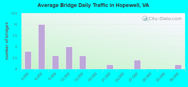
- 264,800Total average daily traffic
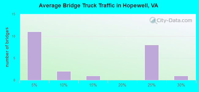
- 33,375Total average daily truck traffic
- National Bridge Inventory (NBI) Registered Bridges for Hopewell
- No street view available for this location
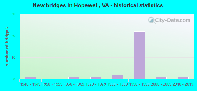
- New bridges - historical statistics
- 11940-1949
- 11960-1969
- 11970-1979
- 21980-1989
- 221990-1999
- 12000-2009
- 12010-2019
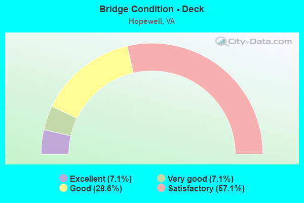
- Bridge Condition - Deck
- 7.1%Excellent
- 7.1%Very good
- 28.6%Good
- 57.1%Satisfactory
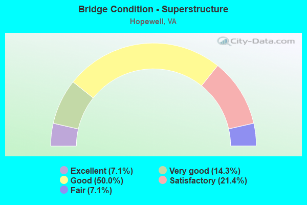
- Bridge Condition - Superstructure
- 7.1%Excellent
- 14.3%Very good
- 50.0%Good
- 21.4%Satisfactory
- 7.1%Fair
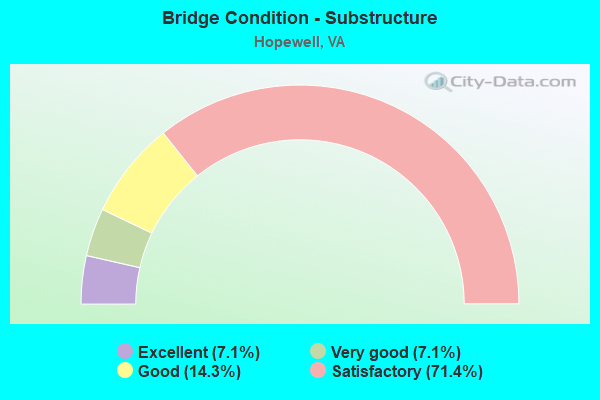
- Bridge Condition - Substructure
- 7.1%Excellent
- 7.1%Very good
- 14.3%Good
- 71.4%Satisfactory
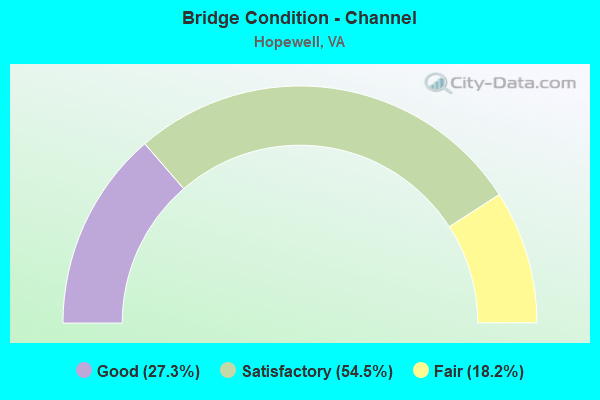
- Bridge Condition - Channel
- 27.3%Good
- 54.5%Satisfactory
- 18.2%Fair
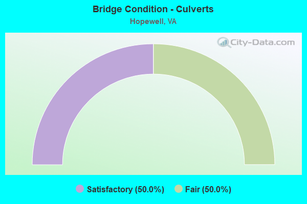
- Bridge Condition - Culverts
- 50.0%Satisfactory
- 50.0%Fair
Find on map >> Show street view
Structure Number: 1403, Location: 0.02Fr HopeCL &1.88 To106 (Lat: 37.289392, Lng: -77.259897), Route carried "on" structure: State highway 10, Year Built: 1974, Status: Open, Structure Length: 30.01m (98.46ft), Average Daily Traffic: 4,128 (year 2020), Truck Traffic: 5%, Average Future Daily Traffic: 5,781 (year 2040), Design Load: HS 20+Mod, Features Intersected: BAILEY CREEK, Facility Carried by Structure: JAMES RIVER ROAD
Minimum Vertical Clearance: 30+ m (98+ ft), Kilometerpoint: 43.739, Lanes on structure: 2, Base Highway Network: Yes, Owner: State Highway Agency, Approaching Roadway Width: 12.2m (40.0ft), Material/Design: Prestressed concrete, Design/Construction: Stringer/Multi-beam, Number Of Spans In Main Unit: 15, Length of Maximum Span: 20.0m (65.6ft), Curb-To-Curb Width: 11.6m (38.1ft), Out-to-Out Width: 12.8m (42.0ft)
Condition: Deck: Satisfactory, Superstructure: Satisfactory, Substructure: Satisfactory, Channel: Satisfactory, Operating Rating: 87.1 metric tons, Method Used To Determine Operating Rating: Load and Resistance Factor (LRFR), Inventory Rating: 57.2 metric tons, Method Used To Determine Inventory Rating: Load and Resistance Factor (LRFR), Structural Evaluation: Equal to present minimum criteria, Deck Geometry: Better than present minimum criteria, Waterway Adequacy: Equal to present desirable criteria, Approach Roadway Alignment: Equal to present desirable criteria, Designated Inspection Frequency: Every 24 months, Underwater Inspection Frequency: Every 60 months, Inspection Date: May 2020, Underwater Inspection Date: May 2020, Deck Structure Type: Concrete Cast-file-Place
Find on map >> Show street view
Structure Number: 14061, Location: .29 TO 646 & .01 SCL HOPE (Lat: 37.273694, Lng: -77.289028), Route carried "on" structure: State highway 156, Year Built: 1948, Status: Open, Structure Length: 2.99m (9.81ft), Average Daily Traffic: 8,767 (year 2020), Truck Traffic: 4%, Average Future Daily Traffic: 10,346 (year 2040), Design Load: H 20, Features Intersected: BAILEYS CREEK, Facility Carried by Structure: PRINCE GEORGE DR.
Minimum Vertical Clearance: 30+ m (98+ ft), Kilometerpoint: 26.005, Lanes on structure: 2, Owner: State Highway Agency, Approaching Roadway Width: 8.5m (27.9ft), Material/Design: Concrete, Design/Construction: Tee Beam, Number Of Spans In Main Unit: 3, Length of Maximum Span: 10.1m (33.1ft), Curb-To-Curb Width: 8.0m (26.2ft), Out-to-Out Width: 9.0m (29.5ft)
Condition: Deck: Satisfactory, Superstructure: Satisfactory, Substructure: Satisfactory, Channel: Satisfactory, Operating Rating: 42.7 metric tons, Method Used To Determine Operating Rating: Load Factor (LF), Inventory Rating: 25.4 metric tons, Method Used To Determine Inventory Rating: Load Factor (LF), Structural Evaluation: Equal to present minimum criteria, Deck Geometry: High priority of replacement, Waterway Adequacy: Equal to present desirable criteria, Approach Roadway Alignment: Equal to present desirable criteria, Length Of Structure Improvement: 2.99m (9.81ft), Designated Inspection Frequency: Every 24 months, Underwater Inspection Frequency: Every 60 months, Inspection Date: October 2021, Underwater Inspection Date: April 2019, Bridge Improvement Cost: $300,000, Roadway Improvement Cost: $50,000, Total Project Cost: $390,000, Deck Structure Type: Concrete Cast-file-Place, Wearing Surface/Protective System: Wearing Surface: Bituminous, Membrane: Preformed Fabric
Find on map >> Show street view
Structure Number: 14069, Location: PRNC GEO & CHRLS CTY CLS (Lat: 37.312611, Lng: -77.222750), Route carried "on" structure: State highway 156, Year Built: 1967, Status: Open, Structure Length: 136.04m (446.33ft), Average Daily Traffic: 5,968 (year 2020), Truck Traffic: 10%, Average Future Daily Traffic: 6,565 (year 2040), Design Load: HS 20+Mod, Features Intersected: JAMES RIVER
Minimum Vertical Clearance: 4.85m (15.91ft), Kilometerpoint: 38.230, Lanes on structure: 2, Owner: State Highway Agency, Approaching Roadway Width: 9.1m (29.9ft), Navigation Control: Yes ( Vertical Clearance: 44.1m (144.7ft), Horizontal Clearance: 91.4m (299.9ft)), Material/Design: Steel, Design/Construction: Movable - Lift, Number Of Spans In Main Unit: 1, Number Of Approach Spans: 65, Length of Maximum Span: 110.8m (363.5ft), Curb or Sidewalk Widths: Left: 0.5m (1.6ft), Right: 0.5m (1.6ft), Curb-To-Curb Width: 7.9m (25.9ft), Out-to-Out Width: 8.8m (28.9ft)
Condition: Deck: Satisfactory, Superstructure: Fair, Substructure: Satisfactory, Channel: Satisfactory, Operating Rating: 52.7 metric tons, Method Used To Determine Operating Rating: Load Factor (LF), Inventory Rating: 31.6 metric tons, Method Used To Determine Inventory Rating: Load Factor (LF), Structural Evaluation: Somewhat better than minimum adequacy, Deck Geometry: High priority of corrective action, Waterway Adequacy: Equal to present desirable criteria, Approach Roadway Alignment: Equal to present desirable criteria, Length Of Structure Improvement: 136.03m (446.29ft), Designated Inspection Frequency: Every 24 months, Critical Feature Inspection Frequency: Every 12 months, Underwater Inspection Frequency: Every 48 months, Inspection Date: July 2021, Critical Feature Inspection Date: July 2021, Underwater Inspection Date: July 2021, Bridge Improvement Cost: $250,000, Roadway Improvement Cost: $50,000, Total Project Cost: $330,000, Deck Structure Type: Concrete Cast-file-Place, Wearing Surface/Protective System: Wearing Surface: Epoxy Overlay
Find on map >> Show street view
Structure Number: 14128, Location: 1.43 Fr 630 & 0.01 To 647 (Lat: 37.253681, Lng: -77.299886), Route carried "on" structure: County highway 646, Year Built: 1984, Status: Open, Structure Length: 0.85m (2.79ft), Average Daily Traffic: 6,746 (year 2020), Truck Traffic: 2%, Average Future Daily Traffic: 7,421 (year 2040), Design Load: HS 20+Mod, Features Intersected: SOUTHERLY RUN, Facility Carried by Structure: MIDDLE ROAD
Minimum Vertical Clearance: 30+ m (98+ ft), Kilometerpoint: 2.309, Lanes on structure: 2, Owner: State Highway Agency, Approaching Roadway Width: 7.3m (24.0ft), Skew: 2 degrees, Material/Design: Concrete, Design/Construction: Culvert, Number Of Spans In Main Unit: 3, Length of Maximum Span: 2.4m (7.9ft)
Condition: Channel: Satisfactory, Culverts: Satisfactory, Operating Rating: 54.4 metric tons, Method Used To Determine Operating Rating: Field evaluation and documented engineering judgment, Inventory Rating: 32.7 metric tons, Method Used To Determine Inventory Rating: Field evaluation and documented engineering judgment, Structural Evaluation: Equal to present minimum criteria, Waterway Adequacy: Equal to present minimum criteria, Approach Roadway Alignment: Equal to present minimum criteria, Designated Inspection Frequency: Every 24 months, Inspection Date: November 2020
Find on map >> Show street view
Structure Number: 20471, Location: 0010LAPRADE A00107TH AVE (Lat: 37.298619, Lng: -77.290475), Route carried "on" structure: City street , Year Built: 1985, Status: Open, Structure Length: 7.07m (23.20ft), Average Daily Traffic: 9,847 (year 2020), Truck Traffic: 4%, Average Future Daily Traffic: 11,689 (year 2040), Design Load: HS 20+Mod, Features Intersected: NS RAILWAY, Facility Carried by Structure: 6TH AVENUE
Minimum Vertical Clearance: 30+ m (98+ ft), Kilometerpoint: 0.402, Lanes on structure: 4, Owner: City or Municipal Highway Agency, Approaching Roadway Width: 15.8m (51.8ft), Material/Design: Steel continuous, Design/Construction: Stringer/Multi-beam, Number Of Spans In Main Unit: 3, Length of Maximum Span: 36.0m (118.1ft), Curb or Sidewalk Widths: Left: 2.4m (7.9ft), Right: 2.4m (7.9ft), Curb-To-Curb Width: 15.8m (51.8ft), Out-to-Out Width: 21.0m (68.9ft)
Condition: Deck: Good, Superstructure: Good, Substructure: Good, Operating Rating: 61.2 metric tons, Method Used To Determine Operating Rating: Load Factor (LF), Inventory Rating: 36.9 metric tons, Method Used To Determine Inventory Rating: Load Factor (LF), Structural Evaluation: Better than present minimum criteria, Deck Geometry: Meets minimum limits, Underclear: Equal to present minimum criteria, Approach Roadway Alignment: Equal to present minimum criteria, Designated Inspection Frequency: Every 24 months, Inspection Date: May 2021, Deck Structure Type: Concrete Cast-file-Place, Wearing Surface/Protective System: Wearing Surface: Monolithic Concrete, Deck Protection: Epoxy Coated Reinforcing
Find on map >> Show street view
Structure Number: 23234, Location: 3.05 Fr 144 & .3 WCL HPWL (Lat: 37.298767, Lng: -77.334297), Route carried "on" structure: County highway 645, Year Built: 1991, Status: Open, Structure Length: 9.46m (31.04ft), Average Daily Traffic: 6,700 (year 2020), Truck Traffic: 4%, Average Future Daily Traffic: 8,419 (year 2040), Design Load: HS 20+Mod, Features Intersected: INTERSTATE-295, Facility Carried by Structure: RIVER ROAD
Minimum Vertical Clearance: 30+ m (98+ ft), Kilometerpoint: 8.238, Lanes on structure: 2, Lanes under structure: 6, Owner: State Highway Agency, Approaching Roadway Width: 10.1m (33.1ft), Skew: 2 degrees, Material/Design: Steel continuous, Design/Construction: Stringer/Multi-beam, Number Of Spans In Main Unit: 2, Number Of Approach Spans: 2, Length of Maximum Span: 35.1m (115.2ft), Curb-To-Curb Width: 9.9m (32.5ft), Out-to-Out Width: 10.9m (35.8ft)
Condition: Deck: Good, Superstructure: Satisfactory, Substructure: Satisfactory, Operating Rating: 63.5 metric tons, Method Used To Determine Operating Rating: Load and Resistance Factor (LRFR), Inventory Rating: 49.0 metric tons, Method Used To Determine Inventory Rating: Load and Resistance Factor (LRFR), Structural Evaluation: Equal to present minimum criteria, Deck Geometry: Meets minimum limits, Underclear: Better than present minimum criteria, Approach Roadway Alignment: Equal to present desirable criteria, Designated Inspection Frequency: Every 24 months, Inspection Date: November 2021, Deck Structure Type: Concrete Cast-file-Place, Wearing Surface/Protective System: Deck Protection: Epoxy Coated Reinforcing
Find on map >> Show street view
Structure Number: 23271, Location: 3.52Fr ChestCo&3.4 To 106 (Lat: 37.266689, Lng: -77.322514), Route carried "on" structure: Interstate 295, Year Built: 1991, Status: Open, Structure Length: 6.46m (21.19ft), Average Daily Traffic: 9,489 (year 2020), Truck Traffic: 25%, Average Future Daily Traffic: 13,285 (year 2040), Design Load: HS 20+Mod, Features Intersected: ROUTE 36
Minimum Vertical Clearance: 30+ m (98+ ft), Kilometerpoint: 69.621, Lanes on structure: 4, Lanes under structure: 8, Base Highway Network: Yes, Owner: State Highway Agency, Approaching Roadway Width: 21.6m (70.9ft), Material/Design: Steel continuous, Design/Construction: Stringer/Multi-beam, Number Of Spans In Main Unit: 2, Length of Maximum Span: 32.0m (105.0ft), Curb-To-Curb Width: 21.5m (70.5ft), Out-to-Out Width: 22.5m (73.8ft)
Condition: Deck: Satisfactory, Superstructure: Good, Substructure: Satisfactory, Inventory Rating: 78.0 metric tons, Method Used To Determine Inventory Rating: Load and Resistance Factor (LRFR), Structural Evaluation: Equal to present minimum criteria, Deck Geometry: Better than present minimum criteria, Underclear: Equal to present minimum criteria, Approach Roadway Alignment: Equal to present desirable criteria, Designated Inspection Frequency: Every 24 months, Inspection Date: October 2021, Deck Structure Type: Concrete Cast-file-Place, Wearing Surface/Protective System: Deck Protection: Epoxy Coated Reinforcing
Find on map >> Show street view
Structure Number: 23277, Location: 3.52Fr Chest Co&3.4To106 (Lat: 37.266956, Lng: -77.322325), Route carried "on" structure: Interstate 295, Year Built: 1991, Status: Open, Structure Length: 6.46m (21.19ft), Average Daily Traffic: 9,586 (year 2020), Truck Traffic: 22%, Average Future Daily Traffic: 13,420 (year 2040), Design Load: HS 20+Mod, Features Intersected: ROUTE 36
Minimum Vertical Clearance: 30+ m (98+ ft), Kilometerpoint: 69.621, Lanes on structure: 3, Lanes under structure: 8, Base Highway Network: Yes, Owner: State Highway Agency, Approaching Roadway Width: 16.2m (53.1ft), Material/Design: Steel continuous, Design/Construction: Stringer/Multi-beam, Number Of Spans In Main Unit: 2, Length of Maximum Span: 32.0m (105.0ft), Curb-To-Curb Width: 16.0m (52.5ft), Out-to-Out Width: 17.0m (55.8ft)
Condition: Deck: Satisfactory, Superstructure: Good, Substructure: Satisfactory, Inventory Rating: 69.9 metric tons, Method Used To Determine Inventory Rating: Load and Resistance Factor (LRFR), Structural Evaluation: Equal to present minimum criteria, Deck Geometry: Equal to present minimum criteria, Underclear: Equal to present minimum criteria, Approach Roadway Alignment: Equal to present desirable criteria, Designated Inspection Frequency: Every 24 months, Inspection Date: October 2021, Deck Structure Type: Concrete Cast-file-Place, Wearing Surface/Protective System: Deck Protection: Epoxy Coated Reinforcing
Find on map >> Show street view
Structure Number: 23281, Location: 0.20 MI. FR. I-295 SBL (Lat: 37.267372, Lng: -77.325156), Route carried "on" structure: Ramp Interstate 295, Year Built: 1991, Status: Open, Structure Length: 6.53m (21.42ft), Average Daily Traffic: 5,819 (year 2020), Average Future Daily Traffic: 8,147 (year 2040), Design Load: HS 20+Mod, Features Intersected: WESTERN ST & NS RWY
Minimum Vertical Clearance: 30+ m (98+ ft), Kilometerpoint: 0.000, Lanes on structure: 1, Lanes under structure: 2, Base Highway Network: Yes, Owner: State Highway Agency, Approaching Roadway Width: 8.8m (28.9ft), Skew: 2 degrees, Material/Design: Steel continuous, Design/Construction: Stringer/Multi-beam, Number Of Spans In Main Unit: 2, Length of Maximum Span: 33.2m (108.9ft), Curb-To-Curb Width: 8.7m (28.5ft), Out-to-Out Width: 9.7m (31.8ft)
Condition: Deck: Good, Superstructure: Good, Substructure: Satisfactory, Operating Rating: 89.8 metric tons, Method Used To Determine Operating Rating: Load and Resistance Factor (LRFR), Inventory Rating: 68.9 metric tons, Method Used To Determine Inventory Rating: Load and Resistance Factor (LRFR), Structural Evaluation: Equal to present minimum criteria, Deck Geometry: Superior to present desirable criteria, Underclear: High priority of corrective action, Approach Roadway Alignment: Equal to present desirable criteria, Designated Inspection Frequency: Every 24 months, Inspection Date: October 2021, Deck Structure Type: Concrete Cast-file-Place, Wearing Surface/Protective System: Deck Protection: Epoxy Coated Reinforcing
Find on map >> Show street view
Structure Number: 23283, Location: 0.20 MI. FR. RTE. 36 WBL (Lat: 37.268744, Lng: -77.322822), Route carried "on" structure: Ramp Interstate 295, Year Built: 1991, Status: Open, Structure Length: 6.11m (20.05ft), Average Daily Traffic: 2,313 (year 2020), Average Future Daily Traffic: 3,238 (year 2040), Design Load: HS 20+Mod, Features Intersected: WESTERN ST & NS RWY
Minimum Vertical Clearance: 30+ m (98+ ft), Kilometerpoint: 0.000, Lanes on structure: 1, Lanes under structure: 2, Base Highway Network: Yes, Owner: State Highway Agency, Approaching Roadway Width: 8.8m (28.9ft), Skew: 3 degrees, Material/Design: Steel continuous, Design/Construction: Stringer/Multi-beam, Number Of Spans In Main Unit: 2, Length of Maximum Span: 29.8m (97.8ft), Curb-To-Curb Width: 8.7m (28.5ft), Out-to-Out Width: 9.7m (31.8ft)
Condition: Deck: Satisfactory, Superstructure: Good, Substructure: Satisfactory, Operating Rating: 90.6 metric tons, Method Used To Determine Operating Rating: Load and Resistance Factor (LRFR), Inventory Rating: 67.1 metric tons, Method Used To Determine Inventory Rating: Load and Resistance Factor (LRFR), Structural Evaluation: Equal to present minimum criteria, Deck Geometry: Superior to present desirable criteria, Underclear: Meets minimum limits, Approach Roadway Alignment: Equal to present desirable criteria, Designated Inspection Frequency: Every 24 months, Inspection Date: October 2021, Deck Structure Type: Concrete Cast-file-Place, Wearing Surface/Protective System: Deck Protection: Epoxy Coated Reinforcing
Find on map >> Show street view
Structure Number: 23287, Location: 3.31 Fr Chstfd &.14 To 36 (Lat: 37.269283, Lng: -77.326742), Route carried "on" structure: Interstate 295, Year Built: 1991, Status: Open, Structure Length: 1.19m (3.90ft), Average Daily Traffic: 19,075 (year 2020), Truck Traffic: 22%, Average Future Daily Traffic: 25,725 (year 2040), Design Load: HS 20+Mod, Features Intersected: CABIN CREEK
Minimum Vertical Clearance: 30+ m (98+ ft), Kilometerpoint: 69.284, Lanes on structure: 6, Base Highway Network: Yes, Owner: State Highway Agency, Approaching Roadway Width: 40.5m (132.9ft), Skew: 4 degrees, Material/Design: Concrete, Design/Construction: Culvert, Number Of Spans In Main Unit: 3, Length of Maximum Span: 1.8m (5.9ft)
Condition: Channel: Good, Culverts: Satisfactory, Operating Rating: 89.8 metric tons, Method Used To Determine Operating Rating: Field evaluation and documented engineering judgment, Inventory Rating: 89.8 metric tons, Method Used To Determine Inventory Rating: Field evaluation and documented engineering judgment, Structural Evaluation: Equal to present minimum criteria, Waterway Adequacy: Equal to present desirable criteria, Approach Roadway Alignment: Equal to present desirable criteria, Designated Inspection Frequency: Every 24 months, Inspection Date: July 2021
Find on map >> Show street view
Structure Number: 23288, Location: 1.66-Chstfd & 1.64 TO 36 (Lat: 37.290419, Lng: -77.329736), Route carried "on" structure: Interstate 295, Year Built: 1991, Status: Open, Structure Length: 0.94m (3.08ft), Average Daily Traffic: 14,664 (year 2020), Truck Traffic: 21%, Average Future Daily Traffic: 20,530 (year 2040), Design Load: H 20, Features Intersected: STREAM
Minimum Vertical Clearance: 30+ m (98+ ft), Kilometerpoint: 66.629, Lanes on structure: 3, Base Highway Network: Yes, Owner: State Highway Agency, Approaching Roadway Width: 17.7m (58.1ft), Material/Design: Steel, Design/Construction: Culvert, Number Of Spans In Main Unit: 3, Length of Maximum Span: 2.1m (6.9ft)
Condition: Channel: Fair, Culverts: Fair, Operating Rating: 54.4 metric tons, Method Used To Determine Operating Rating: Field evaluation and documented engineering judgment, Inventory Rating: 32.7 metric tons, Method Used To Determine Inventory Rating: Field evaluation and documented engineering judgment, Structural Evaluation: Somewhat better than minimum adequacy, Waterway Adequacy: Equal to present desirable criteria, Approach Roadway Alignment: Equal to present desirable criteria, Designated Inspection Frequency: Every 24 months, Inspection Date: December 2021
Find on map >> Show street view
Structure Number: 23289, Location: 1.64-CHSFLD & 1.90-RT.36 (Lat: 37.291081, Lng: -77.328536), Route carried "on" structure: Interstate 295, Year Built: 1991, Status: Open, Structure Length: 1.92m (6.30ft), Average Daily Traffic: 14,221 (year 2020), Truck Traffic: 21%, Average Future Daily Traffic: 19,909 (year 2040), Design Load: H 20, Features Intersected: BULL HILL RUN
Minimum Vertical Clearance: 30+ m (98+ ft), Kilometerpoint: 66.548, Lanes on structure: 3, Base Highway Network: Yes, Owner: State Highway Agency, Approaching Roadway Width: 17.7m (58.1ft), Skew: 3 degrees, Material/Design: Concrete, Design/Construction: Culvert, Number Of Spans In Main Unit: 4, Length of Maximum Span: 2.7m (8.9ft)
Condition: Channel: Satisfactory, Culverts: Fair, Operating Rating: 89.8 metric tons, Method Used To Determine Operating Rating: Field evaluation and documented engineering judgment, Inventory Rating: 89.8 metric tons, Method Used To Determine Inventory Rating: Field evaluation and documented engineering judgment, Structural Evaluation: Somewhat better than minimum adequacy, Waterway Adequacy: Equal to present desirable criteria, Approach Roadway Alignment: Equal to present desirable criteria, Designated Inspection Frequency: Every 24 months, Inspection Date: June 2021
Find on map >> Show street view
Structure Number: 2329, Location: 2.01-CHSTFD & 1.29-RT. 36 (Lat: 37.285647, Lng: -77.329347), Route carried "on" structure: Interstate 295, Year Built: 1991, Status: Open, Structure Length: 1.31m (4.30ft), Average Daily Traffic: 14,664 (year 2020), Truck Traffic: 20%, Average Future Daily Traffic: 20,530 (year 2040), Design Load: H 20, Features Intersected: BULL HILL RUN
Minimum Vertical Clearance: 30+ m (98+ ft), Kilometerpoint: 67.192, Lanes on structure: 3, Base Highway Network: Yes, Owner: State Highway Agency, Approaching Roadway Width: 17.7m (58.1ft), Skew: 4 degrees, Material/Design: Steel, Design/Construction: Culvert, Number Of Spans In Main Unit: 3, Length of Maximum Span: 2.1m (6.9ft)
Condition: Channel: Fair, Culverts: Fair, Operating Rating: 54.4 metric tons, Method Used To Determine Operating Rating: Field evaluation and documented engineering judgment, Inventory Rating: 32.7 metric tons, Method Used To Determine Inventory Rating: Field evaluation and documented engineering judgment, Structural Evaluation: Somewhat better than minimum adequacy, Waterway Adequacy: Equal to present desirable criteria, Approach Roadway Alignment: Equal to present desirable criteria, Designated Inspection Frequency: Every 24 months, Inspection Date: June 2021
Find on map >> Show street view
Structure Number: 23291, Location: 0.40 Fr 36 &0.29 To WLAve (Lat: 37.266739, Lng: -77.325250), Route carried "on" structure: City street , Year Built: 1991, Status: Open, Structure Length: 1.65m (5.41ft), Average Daily Traffic: 3,238 (year 2020), Truck Traffic: 1%, Average Future Daily Traffic: 3,404 (year 2040), Design Load: HS 20+Mod, Features Intersected: CABIN CREEK, Facility Carried by Structure: WESTERN ST. & NSRR
Minimum Vertical Clearance: 30+ m (98+ ft), Kilometerpoint: 0.000, Lanes on structure: 2, Owner: State Highway Agency, Approaching Roadway Width: 9.1m (29.9ft), Skew: 3 degrees, Material/Design: Concrete, Design/Construction: Culvert, Number Of Spans In Main Unit: 4, Length of Maximum Span: 3.0m (9.8ft)
Condition: Channel: Satisfactory, Culverts: Satisfactory, Operating Rating: 54.4 metric tons, Method Used To Determine Operating Rating: Field evaluation and documented engineering judgment, Inventory Rating: 32.7 metric tons, Method Used To Determine Inventory Rating: Field evaluation and documented engineering judgment, Structural Evaluation: Equal to present minimum criteria, Waterway Adequacy: Equal to present desirable criteria, Approach Roadway Alignment: Equal to present desirable criteria, Designated Inspection Frequency: Every 24 months, Inspection Date: August 2021
Find on map >> Show street view
Structure Number: 23403, Location: 0.50 Fr 36 & 6.10 To 460 (Lat: 37.261994, Lng: -77.315544), Route carried "on" structure: Interstate 295, Year Built: 1991, Status: Open, Structure Length: 2.87m (9.42ft), Average Daily Traffic: 9,586 (year 2020), Truck Traffic: 22%, Average Future Daily Traffic: 13,420 (year 2040), Design Load: HS 20+Mod, Features Intersected: BRANDYWINE DRIVE
Minimum Vertical Clearance: 30+ m (98+ ft), Kilometerpoint: 69.782, Lanes on structure: 2, Lanes under structure: 2, Base Highway Network: Yes, Owner: State Highway Agency, Approaching Roadway Width: 12.5m (41.0ft), Material/Design: Steel, Design/Construction: Stringer/Multi-beam, Number Of Spans In Main Unit: 1, Length of Maximum Span: 27.4m (89.9ft), Curb-To-Curb Width: 12.3m (40.4ft), Out-to-Out Width: 13.4m (44.0ft)
Condition: Deck: Satisfactory, Superstructure: Good, Substructure: Satisfactory, Operating Rating: 89.8 metric tons, Method Used To Determine Operating Rating: Load and Resistance Factor (LRFR), Inventory Rating: 86.2 metric tons, Method Used To Determine Inventory Rating: Load and Resistance Factor (LRFR), Structural Evaluation: Equal to present minimum criteria, Deck Geometry: Better than present minimum criteria, Underclear: Somewhat better than minimum adequacy, Approach Roadway Alignment: Equal to present desirable criteria, Designated Inspection Frequency: Every 24 months, Inspection Date: March 2022, Deck Structure Type: Concrete Cast-file-Place, Wearing Surface/Protective System: Deck Protection: Epoxy Coated Reinforcing
Find on map >> Show street view
Structure Number: 23404, Location: 0.50 Fr 36 & 6.10 To 460 (Lat: 37.261817, Lng: -77.315842), Route carried "on" structure: Interstate 295, Year Built: 1991, Status: Open, Structure Length: 2.87m (9.42ft), Average Daily Traffic: 9,489 (year 2020), Truck Traffic: 22%, Average Future Daily Traffic: 13,285 (year 2040), Design Load: HS 20+Mod, Features Intersected: BRANDYWINE DRIVE
Minimum Vertical Clearance: 30+ m (98+ ft), Kilometerpoint: 69.863, Lanes on structure: 3, Lanes under structure: 2, Base Highway Network: Yes, Owner: State Highway Agency, Approaching Roadway Width: 18.0m (59.1ft), Material/Design: Steel, Design/Construction: Stringer/Multi-beam, Number Of Spans In Main Unit: 1, Length of Maximum Span: 27.4m (89.9ft), Curb or Sidewalk Widths: Left: 0.2m (0.7ft), Right: 0.2m (0.7ft), Curb-To-Curb Width: 17.8m (58.4ft), Out-to-Out Width: 18.8m (61.7ft)
Condition: Deck: Satisfactory, Superstructure: Good, Substructure: Satisfactory, Operating Rating: 89.8 metric tons, Method Used To Determine Operating Rating: Load and Resistance Factor (LRFR), Inventory Rating: 89.8 metric tons, Method Used To Determine Inventory Rating: Load and Resistance Factor (LRFR), Structural Evaluation: Equal to present minimum criteria, Deck Geometry: Better than present minimum criteria, Underclear: Somewhat better than minimum adequacy, Approach Roadway Alignment: Equal to present desirable criteria, Designated Inspection Frequency: Every 24 months, Inspection Date: March 2022, Deck Structure Type: Concrete Cast-file-Place, Wearing Surface/Protective System: Deck Protection: Epoxy Coated Reinforcing
Find on map >> Show street view
Structure Number: 24875, Location: 1.24 Fr 156 & 1.19 To 644 (Lat: 37.288664, Lng: -77.258606), Route carried "on" structure: State highway 10, Year Built: 1997, Status: Open, Structure Length: 6.93m (22.74ft), Average Daily Traffic: 4,280 (year 2020), Truck Traffic: 5%, Average Future Daily Traffic: 4,960 (year 2040), Design Load: HS 20+Mod, Features Intersected: BAILEYS CREEK, Facility Carried by Structure: JAMES RIVER DRIVE
Minimum Vertical Clearance: 30+ m (98+ ft), Kilometerpoint: 43.876, Lanes on structure: 2, Base Highway Network: Yes, Owner: State Highway Agency, Approaching Roadway Width: 9.1m (29.9ft), Skew: 3 degrees, Material/Design: Steel, Design/Construction: Stringer/Multi-beam, Number Of Spans In Main Unit: 3, Length of Maximum Span: 22.4m (73.5ft), Curb-To-Curb Width: 9.1m (29.9ft), Out-to-Out Width: 10.2m (33.5ft)
Condition: Deck: Good, Superstructure: Very good, Substructure: Good, Channel: Good, Operating Rating: 80.7 metric tons, Method Used To Determine Operating Rating: Load and Resistance Factor (LRFR), Inventory Rating: 62.6 metric tons, Method Used To Determine Inventory Rating: Load and Resistance Factor (LRFR), Structural Evaluation: Better than present minimum criteria, Deck Geometry: Meets minimum limits, Waterway Adequacy: Equal to present desirable criteria, Approach Roadway Alignment: Equal to present desirable criteria, Designated Inspection Frequency: Every 24 months, Underwater Inspection Frequency: Every 60 months, Inspection Date: December 2020, Underwater Inspection Date: December 2020, Deck Structure Type: Concrete Cast-file-Place, Wearing Surface/Protective System: Deck Protection: Epoxy Coated Reinforcing
Find on map >> Show street view
Structure Number: 27108, Location: .50 WCL HOPEW .51 MESA DR (Lat: 37.295017, Lng: -77.321872), Route carried "on" structure: City street , Year Built: 2007, Status: Open, Structure Length: 0.73m (2.40ft), Average Daily Traffic: 4,439 (year 2020), Truck Traffic: 2%, Average Future Daily Traffic: 5,776 (year 2040), Design Load: HS 20+Mod, Features Intersected: CABIN CREEK, Facility Carried by Structure: RIVER ROAD
Minimum Vertical Clearance: 30+ m (98+ ft), Kilometerpoint: 0.805, Lanes on structure: 3, Owner: City or Municipal Highway Agency, Approaching Roadway Width: 13.4m (44.0ft), Skew: 20 degrees, Material/Design: Concrete, Design/Construction: Arch - Deck, Number Of Spans In Main Unit: 1, Length of Maximum Span: 7.3m (24.0ft), Curb or Sidewalk Widths: Left: 1.5m (4.9ft), Right: 1.5m (4.9ft), Curb-To-Curb Width: 18.3m (60.0ft), Out-to-Out Width: 34.3m (112.5ft)
Condition: Deck: Very good, Superstructure: Very good, Substructure: Very good, Channel: Good, Operating Rating: 75.6 metric tons, Method Used To Determine Operating Rating: Load Factor (LF), Inventory Rating: 47.7 metric tons, Method Used To Determine Inventory Rating: Load Factor (LF), Structural Evaluation: Equal to present desirable criteria, Deck Geometry: Superior to present desirable criteria, Waterway Adequacy: Equal to present desirable criteria, Approach Roadway Alignment: Equal to present desirable criteria, Designated Inspection Frequency: Every 24 months, Inspection Date: May 2021
Find on map >> Show street view
Structure Number: 30965, Location: .01 FR RIVERVIEW (Lat: 37.308806, Lng: -77.274833), Route carried "on" structure: City street , Year Built: 2017, Status: Open, Structure Length: 3.26m (10.70ft), Average Daily Traffic: 1,000 (year 2014), Average Future Daily Traffic: 1,400 (year 2035), Design Load: HL 93, Features Intersected: NS RAILWAY SPUR LINE, Facility Carried by Structure: E BROADWAY AVENUE
Minimum Vertical Clearance: 30+ m (98+ ft), Kilometerpoint: 0.000, Lanes on structure: 2, Owner: City or Municipal Highway Agency, Approaching Roadway Width: 5.8m (19.0ft), Material/Design: Steel continuous, Design/Construction: Stringer/Multi-beam, Number Of Spans In Main Unit: 3, Length of Maximum Span: 11.0m (36.1ft), Curb or Sidewalk Widths: Left: 0.0m, Right: 1.5m (4.9ft), Curb-To-Curb Width: 5.8m (19.0ft), Out-to-Out Width: 7.9m (25.9ft)
Condition: Deck: Excellent, Superstructure: Excellent, Substructure: Excellent, Operating Rating: 60.0 metric tons, Method Used To Determine Operating Rating: Load and Resistance Factor (LRFR), Inventory Rating: 46.3 metric tons, Method Used To Determine Inventory Rating: Load and Resistance Factor (LRFR), Structural Evaluation: Superior to present desirable criteria, Underclear: Equal to present minimum criteria, Approach Roadway Alignment: Meets minimum limits, Designated Inspection Frequency: Every 24 months, Inspection Date: May 2021, Deck Structure Type: Concrete Cast-file-Place, Wearing Surface/Protective System: Wearing Surface: Epoxy Overlay, Deck Protection: Epoxy Coated Reinforcing
Find on map >> Show street view
Structure Number: 23234, Location: 3.05 Fr 144 & .3 WCL HPWL (Lat: 37.298767, Lng: -77.334297), Route carried "under" structure: Interstate 295, Year Built: 1991, Structure Length: 0. m, Average Daily Traffic: 35,000 (year 2018), Truck Traffic: 22%, Features Intersected: INTERSTATE-295, Facility Carried by Structure: RIVER ROAD
Minimum Vertical Clearance: 5.61m (18.41ft), Kilometerpoint: 65.663, Lanes on structure: 2, Lanes under structure: 6, Material/Design: Steel continuous, Design/Construction: Stringer/Multi-beam, Length of Maximum Span: 35.1m (115.2ft)
Find on map >> Show street view
Structure Number: 23271, Location: 3.52Fr ChestCo&3.4 To 106 (Lat: 37.266689, Lng: -77.322514), Route carried "under" structure: State highway 36, Year Built: 1991, Structure Length: 0. m, Average Daily Traffic: 24,000 (year 2020), Truck Traffic: 3%, Features Intersected: ROUTE 36, Facility Carried by Structure: SBL I-295
Minimum Vertical Clearance: 5.66m (18.57ft), Kilometerpoint: 20.611, Lanes on structure: 4, Lanes under structure: 8, Material/Design: Steel continuous, Design/Construction: Stringer/Multi-beam, Length of Maximum Span: 32.0m (105.0ft)
Find on map >> Show street view
Structure Number: 23277, Location: 3.52Fr Chest Co&3.4To106 (Lat: 37.266956, Lng: -77.322325), Route carried "under" structure: State highway 36, Year Built: 1991, Structure Length: 0. m, Average Daily Traffic: 24,000 (year 2020), Truck Traffic: 3%, Features Intersected: ROUTE 36, Facility Carried by Structure: NBL ROUTE 0295
Minimum Vertical Clearance: 5.84m (19.16ft), Kilometerpoint: 20.611, Lanes on structure: 3, Lanes under structure: 8, Material/Design: Steel continuous, Design/Construction: Stringer/Multi-beam, Length of Maximum Span: 32.0m (105.0ft)
Find on map >> Show street view
Structure Number: 23278, Location: 3.35 MI. FR. CHESTFLD. CO (Lat: 37.268150, Lng: -77.324294), Route carried "under" structure: City street , Year Built: 1991, Structure Length: 0. m, Average Daily Traffic: 3,200 (year 2020), Features Intersected: WESTERN ST & NS RWY, Facility Carried by Structure: NBL ROUTE 0295
Minimum Vertical Clearance: 9.55m (31.33ft), Kilometerpoint: 0.000, Lanes on structure: 2, Lanes under structure: 2, Material/Design: Steel continuous, Design/Construction: Stringer/Multi-beam, Length of Maximum Span: 30.2m (99.1ft)
Find on map >> Show street view
Structure Number: 23279, Location: 3.35 MI. FR. CHESTFEILD (Lat: 37.267928, Lng: -77.324536), Route carried "under" structure: City street , Year Built: 1991, Structure Length: 0. m, Average Daily Traffic: 3,200 (year 2020), Features Intersected: WESTERN ST & NS RWY, Facility Carried by Structure: SBL ROUTE 0295
Minimum Vertical Clearance: 9.83m (32.25ft), Kilometerpoint: 0.000, Lanes on structure: 3, Lanes under structure: 2, Material/Design: Steel continuous, Design/Construction: Stringer/Multi-beam, Length of Maximum Span: 30.2m (99.1ft)
Find on map >> Show street view
Structure Number: 23281, Location: 0.20 MI. FR. I-295 SBL (Lat: 37.267372, Lng: -77.325156), Route carried "under" structure: City street , Year Built: 1991, Structure Length: 0. m, Average Daily Traffic: 3,200 (year 2020), Truck Traffic: 1%, Features Intersected: WESTERN ST & NS RWY, Facility Carried by Structure: ROUTE 0295 RAMP D
Minimum Vertical Clearance: 8.76m (28.74ft), Kilometerpoint: 0.000, Lanes on structure: 1, Lanes under structure: 2, Material/Design: Steel continuous, Design/Construction: Stringer/Multi-beam, Length of Maximum Span: 33.2m (108.9ft)
Find on map >> Show street view
Structure Number: 23283, Location: 0.20 MI. FR. RTE. 36 WBL (Lat: 37.268744, Lng: -77.322822), Route carried "under" structure: City street , Year Built: 1991, Structure Length: 0. m, Average Daily Traffic: 3,200 (year 2020), Truck Traffic: 1%, Features Intersected: WESTERN ST & NS RWY, Facility Carried by Structure: ROUTE 0295 RAMP A
Minimum Vertical Clearance: 7.47m (24.51ft), Kilometerpoint: 0.000, Lanes on structure: 1, Lanes under structure: 2, Material/Design: Steel continuous, Design/Construction: Stringer/Multi-beam, Length of Maximum Span: 29.8m (97.8ft)
Find on map >> Show street view
Structure Number: 23403, Location: 0.50 Fr 36 & 6.10 To 460 (Lat: 37.261994, Lng: -77.315544), Route carried "under" structure: City street , Year Built: 1991, Structure Length: 0. m, Average Daily Traffic: 2,200 (year 2017), Truck Traffic: 1%, Features Intersected: BRANDYWINE DRIVE, Facility Carried by Structure: INTERSTATE-295 WBL
Minimum Vertical Clearance: 5.46m (17.91ft), Kilometerpoint: 0.113, Lanes on structure: 2, Lanes under structure: 2, Material/Design: Steel, Design/Construction: Stringer/Multi-beam, Length of Maximum Span: 27.4m (89.9ft)
Find on map >> Show street view
Structure Number: 23404, Location: 0.50 Fr 36 & 6.10 To 460 (Lat: 37.261817, Lng: -77.315842), Route carried "under" structure: City street , Year Built: 1991, Structure Length: 0. m, Average Daily Traffic: 2,781 (year 2005), Features Intersected: BRANDYWINE DRIVE, Facility Carried by Structure: INTERSTATE-295 EBL
Minimum Vertical Clearance: 4.65m (15.26ft), Kilometerpoint: 0.113, Lanes on structure: 3, Lanes under structure: 2, Material/Design: Steel, Design/Construction: Stringer/Multi-beam, Length of Maximum Span: 27.4m (89.9ft)