Bridge Statistics for Horn Lake, Mississippi (MS)
Condition, Traffic, Stress, Structural Evaluation, Project Costs
- National Bridge Inventory (NBI) Statistics
- 20Number of bridges
- 217ft / 66.1mTotal length
- $2,999,997,000Total costs
- 334,050Total average daily traffic
- 23,552Total average daily truck traffic
- National Bridge Inventory (NBI) Registered Bridges for Horn Lake
- No street view available for this location
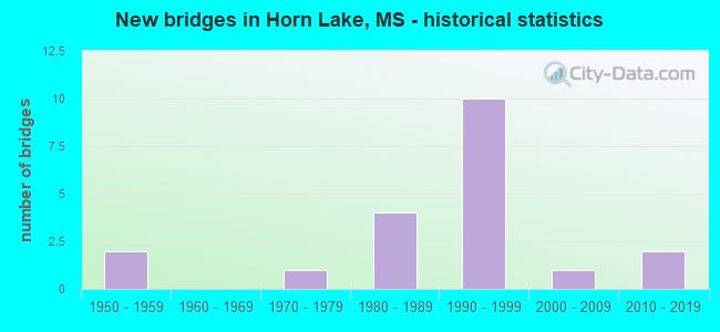
- New bridges - historical statistics
- 21950-1959
- 11970-1979
- 41980-1989
- 101990-1999
- 12000-2009
- 22010-2019


- Bridge Condition - Deck
- 28.6%Very good
- 42.9%Good
- 28.6%Fair

- Bridge Condition - Superstructure
- 28.6%Very good
- 42.9%Good
- 28.6%Fair

- Bridge Condition - Substructure
- 71.4%Good
- 28.6%Satisfactory

- Bridge Condition - Channel
- 26.3%Very good
- 26.3%Good
- 21.1%Satisfactory
- 21.1%Fair
- 5.3%Poor

- Bridge Condition - Culverts
- 25.0%Very good
- 50.0%Good
- 25.0%Satisfactory
Find on map >> Show street view
Structure Number: 11000550172893A, Location: 2.9 MI S TENN ST LINE (Lat: 34.953917, Lng: -89.997967), Route carried "on" structure: Interstate 55, Year Built: 1958, Status: Open, Structure Length: 8.60m (28.22ft), Average Daily Traffic: 33,500 (year 2020), Truck Traffic: 13%, Average Future Daily Traffic: 41,000 (year 2040), Design Load: HS 20+Mod, Features Intersected: HORN LAKE CREEK
Minimum Vertical Clearance: 30+ m (98+ ft), Kilometerpoint: 4.593, Lanes on structure: 2, Base Highway Network: Yes (Inventory Route: 6, Subroute: 1), Owner: State Highway Agency, Approaching Roadway Width: 8.5m (27.9ft), Material/Design: Concrete continuous, Design/Construction: Box Beam or Girders - Single/Spread, Number Of Spans In Main Unit: 3, Number Of Approach Spans: 3, Length of Maximum Span: 20.4m (66.9ft), Curb or Sidewalk Widths: Left: 0.5m (1.6ft), Right: 0.5m (1.6ft), Curb-To-Curb Width: 8.5m (27.9ft), Out-to-Out Width: 9.1m (29.9ft)
Condition: Deck: Fair, Superstructure: Fair, Substructure: Satisfactory, Channel: Fair, Operating Rating: 42.4 metric tons, Method Used To Determine Operating Rating: Load Factor (LF), Inventory Rating: 25.4 metric tons, Method Used To Determine Inventory Rating: Load Factor (LF), Structural Evaluation: Somewhat better than minimum adequacy, Deck Geometry: High priority of corrective action, Waterway Adequacy: Equal to present minimum criteria, Approach Roadway Alignment: Equal to present desirable criteria, Length Of Structure Improvement: 10.97m (35.99ft), Designated Inspection Frequency: Every 24 months, Underwater Inspection Frequency: Every 60 months, Inspection Date: March 2020, Underwater Inspection Date: April 2020, Bridge Improvement Cost: $999,999,000, Roadway Improvement Cost: $102,000,000, Total Project Cost: $999,999,000, Deck Structure Type: Concrete Cast-file-Place
Find on map >> Show street view
Structure Number: 11000550172893B, Location: 2.9 MI S TENN ST LINE (Lat: 34.952978, Lng: -89.997528), Route carried "on" structure: Interstate 55, Year Built: 1958, Status: Open, Structure Length: 8.60m (28.22ft), Average Daily Traffic: 33,500 (year 2020), Truck Traffic: 13%, Average Future Daily Traffic: 41,000 (year 2040), Design Load: HS 20+Mod, Features Intersected: HORN LAKE CREEK
Minimum Vertical Clearance: 30+ m (98+ ft), Kilometerpoint: 31.389, Lanes on structure: 2, Base Highway Network: Yes (Inventory Route: 6, Subroute: 2), Owner: State Highway Agency, Approaching Roadway Width: 8.5m (27.9ft), Material/Design: Concrete continuous, Design/Construction: Box Beam or Girders - Single/Spread, Number Of Spans In Main Unit: 3, Number Of Approach Spans: 3, Length of Maximum Span: 20.4m (66.9ft), Curb or Sidewalk Widths: Left: 0.5m (1.6ft), Right: 0.5m (1.6ft), Curb-To-Curb Width: 8.5m (27.9ft), Out-to-Out Width: 9.1m (29.9ft)
Condition: Deck: Fair, Superstructure: Fair, Substructure: Satisfactory, Channel: Fair, Operating Rating: 42.4 metric tons, Method Used To Determine Operating Rating: Load Factor (LF), Inventory Rating: 25.4 metric tons, Method Used To Determine Inventory Rating: Load Factor (LF), Structural Evaluation: Somewhat better than minimum adequacy, Deck Geometry: High priority of corrective action, Waterway Adequacy: Equal to present minimum criteria, Approach Roadway Alignment: Equal to present desirable criteria, Length Of Structure Improvement: 10.97m (35.99ft), Designated Inspection Frequency: Every 24 months, Underwater Inspection Frequency: Every 60 months, Inspection Date: March 2020, Underwater Inspection Date: April 2020, Bridge Improvement Cost: $999,999,000, Roadway Improvement Cost: $102,000,000, Total Project Cost: $999,999,000, Deck Structure Type: Concrete Cast-file-Place
Find on map >> Show street view
Structure Number: 21000510172957, Location: 0.1 MI S SR 302 (Lat: 34.961736, Lng: -90.016500), Route carried "on" structure: US 51, Year Built: 1981, Status: Open, Structure Length: 0.91m (2.99ft), Average Daily Traffic: 16,000 (year 2020), Truck Traffic: 7%, Average Future Daily Traffic: 18,000 (year 2040), Design Load: HS 20, Features Intersected: STREAM
Minimum Vertical Clearance: 30+ m (98+ ft), Kilometerpoint: 27.148, Lanes on structure: 5, Base Highway Network: Yes (Inventory Route: 5, Subroute: 1), Owner: State Highway Agency, Approaching Roadway Width: 22.9m (75.1ft), Skew: 4 degrees, Material/Design: Concrete, Design/Construction: Culvert, Number Of Spans In Main Unit: 2, Length of Maximum Span: 4.6m (15.1ft)
Condition: Channel: Good, Culverts: Good, Operating Rating: 80.3 metric tons, Method Used To Determine Operating Rating: Load Factor (LF), Inventory Rating: 48.1 metric tons, Method Used To Determine Inventory Rating: Load Factor (LF), Structural Evaluation: Better than present minimum criteria, Waterway Adequacy: Equal to present desirable criteria, Approach Roadway Alignment: Equal to present desirable criteria, Designated Inspection Frequency: Every 24 months, Inspection Date: June 2020
Find on map >> Show street view
Structure Number: 21000510172959, Location: 0.1 MI N SR 302 (Lat: 34.964750, Lng: -90.016453), Route carried "on" structure: US 51, Year Built: 1980, Status: Open, Structure Length: 10.12m (33.20ft), Average Daily Traffic: 23,000 (year 2020), Truck Traffic: 4%, Average Future Daily Traffic: 25,000 (year 2040), Design Load: HS 20, Features Intersected: HORN LAKE CREEK
Minimum Vertical Clearance: 30+ m (98+ ft), Kilometerpoint: 27.483, Lanes on structure: 5, Base Highway Network: Yes (Inventory Route: 5, Subroute: 1), Owner: State Highway Agency, Approaching Roadway Width: 19.3m (63.3ft), Material/Design: Prestressed concrete, Design/Construction: Stringer/Multi-beam, Number Of Spans In Main Unit: 5, Number Of Approach Spans: 2, Length of Maximum Span: 15.2m (49.9ft), Curb or Sidewalk Widths: Left: 0.0m, Right: 1.7m (5.6ft), Curb-To-Curb Width: 19.3m (63.3ft), Out-to-Out Width: 22.1m (72.5ft)
Condition: Deck: Good, Superstructure: Very good, Substructure: Good, Channel: Very good, Operating Rating: 48.0 metric tons, Method Used To Determine Operating Rating: Load Factor (LF), Inventory Rating: 28.8 metric tons, Method Used To Determine Inventory Rating: Load Factor (LF), Structural Evaluation: Better than present minimum criteria, Deck Geometry: Meets minimum limits, Waterway Adequacy: Equal to present desirable criteria, Approach Roadway Alignment: Equal to present desirable criteria, Designated Inspection Frequency: Every 24 months, Inspection Date: December 2020, Deck Structure Type: Concrete Cast-file-Place
Find on map >> Show street view
Structure Number: 31003010170263, Location: 8.4 MI N SR 304 (Lat: 34.928719, Lng: -90.096058), Route carried "on" structure: State highway 301, Year Built: 1998, Status: Open, Structure Length: 8.59m (28.18ft), Average Daily Traffic: 3,400 (year 2020), Truck Traffic: 10%, Average Future Daily Traffic: 3,600 (year 2040), Design Load: HS 20, Features Intersected: JOHNSON CREEK
Minimum Vertical Clearance: 30+ m (98+ ft), Kilometerpoint: 23.010, Lanes on structure: 2, Base Highway Network: Yes (Inventory Route: 30, Subroute: 1), Owner: State Highway Agency, Approaching Roadway Width: 13.4m (44.0ft), Skew: 2 degrees, Material/Design: Prestressed concrete, Design/Construction: Stringer/Multi-beam, Number Of Spans In Main Unit: 1, Number Of Approach Spans: 5, Length of Maximum Span: 24.4m (80.1ft), Curb-To-Curb Width: 13.4m (44.0ft), Out-to-Out Width: 14.3m (46.9ft)
Condition: Deck: Very good, Superstructure: Good, Substructure: Good, Channel: Satisfactory, Operating Rating: 61.0 metric tons, Method Used To Determine Operating Rating: Load Factor (LF), Inventory Rating: 29.8 metric tons, Method Used To Determine Inventory Rating: Load Factor (LF), Structural Evaluation: Better than present minimum criteria, Deck Geometry: Better than present minimum criteria, Waterway Adequacy: Equal to present desirable criteria, Approach Roadway Alignment: Equal to present desirable criteria, Designated Inspection Frequency: Every 48 months, Inspection Date: April 2018, Deck Structure Type: Concrete Cast-file-Place
Find on map >> Show street view
Structure Number: 31003020170054, Location: 2.2 MI W US 51 (Lat: 34.962639, Lng: -90.055125), Route carried "on" structure: State highway 302, Year Built: 1994, Status: Open, Structure Length: 0.64m (2.10ft), Average Daily Traffic: 26,000 (year 2020), Truck Traffic: 4%, Average Future Daily Traffic: 29,000 (year 2040), Design Load: HS 20, Features Intersected: STREAM
Minimum Vertical Clearance: 30+ m (98+ ft), Kilometerpoint: 8.465, Lanes on structure: 5, Base Highway Network: Yes (Inventory Route: 30, Subroute: 1), Owner: State Highway Agency, Approaching Roadway Width: 19.5m (64.0ft), Skew: 1 degrees, Material/Design: Concrete, Design/Construction: Culvert, Number Of Spans In Main Unit: 2, Length of Maximum Span: 3.0m (9.8ft)
Condition: Channel: Good, Culverts: Very good, Operating Rating: 47.4 metric tons, Method Used To Determine Operating Rating: Load Factor (LF), Inventory Rating: 28.4 metric tons, Method Used To Determine Inventory Rating: Load Factor (LF), Structural Evaluation: Better than present minimum criteria, Waterway Adequacy: Equal to present desirable criteria, Approach Roadway Alignment: Equal to present desirable criteria, Designated Inspection Frequency: Every 24 months, Inspection Date: August 2021
Find on map >> Show street view
Structure Number: 31003020170063, Location: 1.3 MI W US 51 (Lat: 34.962622, Lng: -90.039214), Route carried "on" structure: State highway 302, Year Built: 1994, Status: Open, Structure Length: 3.66m (12.01ft), Average Daily Traffic: 26,000 (year 2020), Truck Traffic: 4%, Average Future Daily Traffic: 29,000 (year 2040), Design Load: HS 20, Features Intersected: COWPEN CREEK
Minimum Vertical Clearance: 30+ m (98+ ft), Kilometerpoint: 9.918, Lanes on structure: 5, Base Highway Network: Yes (Inventory Route: 30, Subroute: 1), Owner: State Highway Agency, Approaching Roadway Width: 18.3m (60.0ft), Material/Design: Prestressed concrete continuous, Design/Construction: Stringer/Multi-beam, Number Of Spans In Main Unit: 3, Length of Maximum Span: 12.2m (40.0ft), Curb or Sidewalk Widths: Left: 0.0m, Right: 1.5m (4.9ft), Curb-To-Curb Width: 18.3m (60.0ft), Out-to-Out Width: 20.9m (68.6ft)
Condition: Deck: Good, Superstructure: Very good, Substructure: Good, Channel: Very good, Operating Rating: 62.5 metric tons, Method Used To Determine Operating Rating: Load Factor (LF), Inventory Rating: 37.4 metric tons, Method Used To Determine Inventory Rating: Load Factor (LF), Structural Evaluation: Better than present minimum criteria, Deck Geometry: High priority of replacement, Waterway Adequacy: Equal to present desirable criteria, Approach Roadway Alignment: Equal to present desirable criteria, Length Of Structure Improvement: 4.75m (15.58ft), Designated Inspection Frequency: Every 24 months, Inspection Date: August 2021, Bridge Improvement Cost: $575,000,000, Roadway Improvement Cost: $58,000,000, Total Project Cost: $999,999,000, Deck Structure Type: Concrete Cast-file-Place
Find on map >> Show street view
Structure Number: 31003020170069, Location: 0.7 MI W US 51 (Lat: 34.962642, Lng: -90.028997), Route carried "on" structure: State highway 302, Year Built: 1994, Status: Open, Structure Length: 0.64m (2.10ft), Average Daily Traffic: 35,000 (year 2020), Truck Traffic: 3%, Average Future Daily Traffic: 38,000 (year 2040), Design Load: HS 20, Features Intersected: STREAM
Minimum Vertical Clearance: 30+ m (98+ ft), Kilometerpoint: 10.852, Lanes on structure: 5, Base Highway Network: Yes (Inventory Route: 30, Subroute: 1), Owner: State Highway Agency, Approaching Roadway Width: 19.5m (64.0ft), Skew: 1 degrees, Material/Design: Concrete, Design/Construction: Culvert, Number Of Spans In Main Unit: 2, Length of Maximum Span: 3.0m (9.8ft)
Condition: Channel: Good, Culverts: Very good, Operating Rating: 45.9 metric tons, Method Used To Determine Operating Rating: Load Factor (LF), Inventory Rating: 27.9 metric tons, Method Used To Determine Inventory Rating: Load Factor (LF), Structural Evaluation: Better than present minimum criteria, Waterway Adequacy: Equal to present desirable criteria, Approach Roadway Alignment: Equal to present desirable criteria, Designated Inspection Frequency: Every 24 months, Inspection Date: August 2021
Find on map >> Show street view
Structure Number: 31003020170071, Location: 0.5 MI W US 51 (Lat: 34.962639, Lng: -90.024581), Route carried "on" structure: State highway 302, Year Built: 1994, Status: Open, Structure Length: 1.01m (3.31ft), Average Daily Traffic: 35,000 (year 2020), Truck Traffic: 3%, Average Future Daily Traffic: 38,000 (year 2040), Design Load: HS 20, Features Intersected: STREAM
Minimum Vertical Clearance: 30+ m (98+ ft), Kilometerpoint: 11.254, Lanes on structure: 5, Base Highway Network: Yes (Inventory Route: 30, Subroute: 1), Owner: State Highway Agency, Approaching Roadway Width: 19.5m (64.0ft), Material/Design: Concrete, Design/Construction: Culvert, Number Of Spans In Main Unit: 2, Length of Maximum Span: 4.9m (16.1ft)
Condition: Channel: Very good, Culverts: Very good, Inventory Rating: 65.7 metric tons, Method Used To Determine Inventory Rating: Load Factor (LF), Structural Evaluation: Equal to present desirable criteria, Waterway Adequacy: Equal to present desirable criteria, Approach Roadway Alignment: Equal to present desirable criteria, Designated Inspection Frequency: Every 24 months, Inspection Date: August 2021
Find on map >> Show street view
Structure Number: 31003020170073, Location: 0.3 MI W US 51 (Lat: 34.962636, Lng: -90.020786), Route carried "on" structure: State highway 302, Year Built: 1994, Status: Open, Structure Length: 0.64m (2.10ft), Average Daily Traffic: 35,000 (year 2020), Truck Traffic: 3%, Average Future Daily Traffic: 38,000 (year 2040), Design Load: HS 20, Features Intersected: STREAM
Minimum Vertical Clearance: 30+ m (98+ ft), Kilometerpoint: 11.602, Lanes on structure: 5, Base Highway Network: Yes (Inventory Route: 30, Subroute: 1), Owner: State Highway Agency, Approaching Roadway Width: 19.5m (64.0ft), Material/Design: Concrete, Design/Construction: Culvert, Number Of Spans In Main Unit: 2, Length of Maximum Span: 3.0m (9.8ft)
Condition: Channel: Good, Culverts: Good, Operating Rating: 65.7 metric tons, Method Used To Determine Operating Rating: Load Factor (LF), Inventory Rating: 39.6 metric tons, Method Used To Determine Inventory Rating: Load Factor (LF), Structural Evaluation: Better than present minimum criteria, Waterway Adequacy: Equal to present desirable criteria, Approach Roadway Alignment: Equal to present desirable criteria, Designated Inspection Frequency: Every 24 months, Inspection Date: August 2021
Find on map >> Show street view
Structure Number: 31003020170077, Location: 0.1 MI E US 51 (Lat: 34.962658, Lng: -90.014664), Route carried "on" structure: State highway 302, Year Built: 1986, Status: Open, Structure Length: 5.55m (18.21ft), Average Daily Traffic: 34,000 (year 2020), Truck Traffic: 4%, Average Future Daily Traffic: 38,000 (year 2040), Design Load: HS 20, Features Intersected: HORN LAKE CREEK
Minimum Vertical Clearance: 30+ m (98+ ft), Kilometerpoint: 12.159, Lanes on structure: 5, Base Highway Network: Yes (Inventory Route: 30, Subroute: 1), Owner: State Highway Agency, Approaching Roadway Width: 19.3m (63.3ft), Material/Design: Prestressed concrete, Design/Construction: Stringer/Multi-beam, Number Of Spans In Main Unit: 1, Number Of Approach Spans: 3, Length of Maximum Span: 18.3m (60.0ft), Curb or Sidewalk Widths: Left: 0.0m, Right: 1.7m (5.6ft), Curb-To-Curb Width: 19.3m (63.3ft), Out-to-Out Width: 22.4m (73.5ft)
Condition: Deck: Very good, Superstructure: Good, Substructure: Good, Channel: Satisfactory, Operating Rating: 53.2 metric tons, Method Used To Determine Operating Rating: Load Factor (LF), Inventory Rating: 28.7 metric tons, Method Used To Determine Inventory Rating: Load Factor (LF), Structural Evaluation: Better than present minimum criteria, Deck Geometry: Meets minimum limits, Waterway Adequacy: Equal to present desirable criteria, Approach Roadway Alignment: Equal to present desirable criteria, Designated Inspection Frequency: Every 24 months, Inspection Date: August 2021, Deck Structure Type: Concrete Cast-file-Place
Find on map >> Show street view
Structure Number: SA1700000000002, Location: SEC 20 T 1S R 6W (Lat: 34.988383, Lng: -89.862767), Route carried "on" structure: County highway 679, Year Built: 1996, Status: Open, Structure Length: 0.80m (2.62ft), Average Daily Traffic: 1,000 (year 2020), Truck Traffic: 20%, Average Future Daily Traffic: 1,500 (year 2040), Design Load: HS 20, Features Intersected: UNNAMED CREEK, Facility Carried by Structure: OLD CRAFT ROAD
Minimum Vertical Clearance: 30+ m (98+ ft), Kilometerpoint: 0.160, Lanes on structure: 2, Owner: County Highway Agency, Approaching Roadway Width: 6.7m (22.0ft), Material/Design: Concrete, Design/Construction: Culvert, Number Of Spans In Main Unit: 2, Length of Maximum Span: 3.7m (12.1ft)
Condition: Channel: Satisfactory, Culverts: Good, Operating Rating: 42.5 metric tons, Method Used To Determine Operating Rating: Load Factor (LF), Inventory Rating: 25.5 metric tons, Method Used To Determine Inventory Rating: Load Factor (LF), Structural Evaluation: Equal to present minimum criteria, Waterway Adequacy: Equal to present minimum criteria, Approach Roadway Alignment: Equal to present desirable criteria, Designated Inspection Frequency: Every 24 months, Inspection Date: April 2021
Find on map >> Show street view
Structure Number: SA1700000000011, Location: SEC 29 T 1S R 8W B (Lat: 34.977150, Lng: -90.077233), Route carried "on" structure: County highway 1008, Year Built: 1986, Status: Open, Structure Length: 0.80m (2.62ft), Average Daily Traffic: 1,000 (year 2020), Truck Traffic: 20%, Average Future Daily Traffic: 1,500 (year 2040), Design Load: HS 20, Features Intersected: UNNAMED DITCH, Facility Carried by Structure: DESOTO ROAD
Minimum Vertical Clearance: 30+ m (98+ ft), Kilometerpoint: 1.448, Lanes on structure: 2, Owner: County Highway Agency, Approaching Roadway Width: 9.1m (29.9ft), Material/Design: Concrete, Design/Construction: Culvert, Number Of Spans In Main Unit: 2, Length of Maximum Span: 3.7m (12.1ft)
Condition: Channel: Fair, Culverts: Satisfactory, Operating Rating: 51.6 metric tons, Method Used To Determine Operating Rating: Load Factor (LF), Inventory Rating: 31.1 metric tons, Method Used To Determine Inventory Rating: Load Factor (LF), Structural Evaluation: Equal to present minimum criteria, Waterway Adequacy: Equal to present minimum criteria, Approach Roadway Alignment: Equal to present desirable criteria, Designated Inspection Frequency: Every 24 months, Inspection Date: April 2021
Find on map >> Show street view
Structure Number: SA1700000000012, Location: SEC 34 T 1S R 8W B (Lat: 34.948183, Lng: -90.038300), Route carried "on" structure: City street 9227, Year Built: 1977, Status: Open, Structure Length: 1.07m (3.51ft), Average Daily Traffic: 15,000 (year 2020), Truck Traffic: 20%, Average Future Daily Traffic: 22,500 (year 2040), Design Load: HS 20, Features Intersected: COWPEN CREEK, Facility Carried by Structure: NAIL ROAD
Minimum Vertical Clearance: 30+ m (98+ ft), Kilometerpoint: 5.288, Lanes on structure: 5, Owner: City or Municipal Highway Agency, Approaching Roadway Width: 21.2m (69.6ft), Material/Design: Concrete, Design/Construction: Culvert, Number Of Spans In Main Unit: 2, Length of Maximum Span: 4.9m (16.1ft)
Condition: Channel: Fair, Culverts: Satisfactory, Operating Rating: 54.6 metric tons, Method Used To Determine Operating Rating: Load Factor (LF), Inventory Rating: 32.7 metric tons, Method Used To Determine Inventory Rating: Load Factor (LF), Structural Evaluation: Equal to present minimum criteria, Waterway Adequacy: Better than present minimum criteria, Approach Roadway Alignment: Equal to present desirable criteria, Designated Inspection Frequency: Every 24 months, Inspection Date: April 2021
Find on map >> Show street view
Structure Number: SA1700000000032, Location: SEC 3 T 2S R 8W B (Lat: 34.933567, Lng: -90.032783), Route carried "on" structure: City street 7867, Year Built: 1991, Status: Open, Structure Length: 0.82m (2.69ft), Average Daily Traffic: 4,000 (year 2020), Truck Traffic: 20%, Average Future Daily Traffic: 6,000 (year 2040), Design Load: HS 20, Features Intersected: COWPEN CREEK, Facility Carried by Structure: CHURCH ROAD
Minimum Vertical Clearance: 30+ m (98+ ft), Kilometerpoint: 5.760, Lanes on structure: 2, Owner: City or Municipal Highway Agency, Approaching Roadway Width: 9.1m (29.9ft), Material/Design: Concrete, Design/Construction: Culvert, Number Of Spans In Main Unit: 2, Length of Maximum Span: 3.7m (12.1ft), Curb or Sidewalk Widths: Left: 0.2m (0.7ft), Right: 0.2m (0.7ft)
Condition: Channel: Poor, Culverts: Satisfactory, Operating Rating: 71.6 metric tons, Method Used To Determine Operating Rating: Load Factor (LF), Inventory Rating: 42.8 metric tons, Method Used To Determine Inventory Rating: Load Factor (LF), Structural Evaluation: Equal to present minimum criteria, Waterway Adequacy: Equal to present minimum criteria, Approach Roadway Alignment: Equal to present desirable criteria, Designated Inspection Frequency: Every 24 months, Inspection Date: April 2021
Find on map >> Show street view
Structure Number: SA1700000000034, Location: SEC 6 T 2S R 8W B (Lat: 34.933333, Lng: -90.087250), Route carried "on" structure: City street 7867, Year Built: 1993, Status: Open, Structure Length: 1.34m (4.40ft), Average Daily Traffic: 4,000 (year 2020), Truck Traffic: 20%, Average Future Daily Traffic: 6,000 (year 2040), Design Load: HS 20, Features Intersected: JOHNSON CREEK, Facility Carried by Structure: CHURCH ROAD
Minimum Vertical Clearance: 30+ m (98+ ft), Kilometerpoint: 0.800, Lanes on structure: 2, Owner: City or Municipal Highway Agency, Approaching Roadway Width: 7.3m (24.0ft), Skew: 3 degrees, Material/Design: Concrete, Design/Construction: Culvert, Number Of Spans In Main Unit: 2, Length of Maximum Span: 5.5m (18.0ft)
Condition: Channel: Satisfactory, Culverts: Good, Operating Rating: 60.5 metric tons, Method Used To Determine Operating Rating: Load Factor (LF), Inventory Rating: 36.3 metric tons, Method Used To Determine Inventory Rating: Load Factor (LF), Structural Evaluation: Better than present minimum criteria, Waterway Adequacy: Equal to present minimum criteria, Approach Roadway Alignment: Equal to present desirable criteria, Designated Inspection Frequency: Every 24 months, Inspection Date: April 2021
Find on map >> Show street view
Structure Number: SA1700000000111, Location: SEC 36 T 1S R 8W (Lat: 34.954233, Lng: -90.006183), Route carried "on" structure: City street 131, Year Built: 2002, Status: Open, Structure Length: 9.88m (32.41ft), Average Daily Traffic: 3,000 (year 2018), Truck Traffic: 8%, Average Future Daily Traffic: 4,500 (year 2038), Design Load: HS 20, Features Intersected: HORN LAKE CREEK, Facility Carried by Structure: INTERSTATE BLVD.
Minimum Vertical Clearance: 30+ m (98+ ft), Kilometerpoint: 1.480, Lanes on structure: 6, Owner: City or Municipal Highway Agency, Approaching Roadway Width: 24.4m (80.1ft), Skew: 22 degrees, Material/Design: Prestressed concrete, Design/Construction: Stringer/Multi-beam, Number Of Spans In Main Unit: 3, Length of Maximum Span: 35.1m (115.2ft), Curb or Sidewalk Widths: Left: 1.9m (6.2ft), Right: 1.9m (6.2ft), Curb-To-Curb Width: 29.3m (96.1ft), Out-to-Out Width: 33.1m (108.6ft)
Condition: Deck: Good, Superstructure: Good, Substructure: Good, Channel: Good, Operating Rating: 43.2 metric tons, Method Used To Determine Operating Rating: Allowable Stress (AS), Inventory Rating: 32.4 metric tons, Method Used To Determine Inventory Rating: Allowable Stress (AS), Structural Evaluation: Better than present minimum criteria, Deck Geometry: Superior to present desirable criteria, Waterway Adequacy: Better than present minimum criteria, Approach Roadway Alignment: Equal to present desirable criteria, Designated Inspection Frequency: Every 24 months, Inspection Date: May 2020, Deck Structure Type: Concrete Cast-file-Place, Wearing Surface/Protective System: Wearing Surface: Monolithic Concrete
Find on map >> Show street view
Structure Number: SA170000000A013, Location: SEC 34 T 1S R 8W (Lat: 34.951389, Lng: -90.040556), Route carried "on" structure: Alternate County highway 2000, Year Built: 2015, Status: Open, Structure Length: 1.17m (3.84ft), Average Daily Traffic: 1,500 (year 2020), Truck Traffic: 20%, Average Future Daily Traffic: 2,250 (year 2040), Design Load: HS 20, Features Intersected: COWPEN CREEK, Facility Carried by Structure: VALLEYBROOK DRIVE
Minimum Vertical Clearance: 30+ m (98+ ft), Kilometerpoint: 0.321, Lanes on structure: 2, Owner: City or Municipal Highway Agency, Approaching Roadway Width: 12.8m (42.0ft), Material/Design: Concrete, Design/Construction: Culvert, Number Of Spans In Main Unit: 2, Length of Maximum Span: 5.5m (18.0ft)
Condition: Channel: Very good, Culverts: Good, Operating Rating: 53.9 metric tons, Method Used To Determine Operating Rating: Load Factor (LF), Inventory Rating: 32.4 metric tons, Method Used To Determine Inventory Rating: Load Factor (LF), Structural Evaluation: Better than present minimum criteria, Waterway Adequacy: Better than present minimum criteria, Approach Roadway Alignment: Equal to present minimum criteria, Designated Inspection Frequency: Every 24 months, Inspection Date: April 2021
Find on map >> Show street view
Structure Number: SA170000000A014, Location: SEC 34 T 1S R 8W (Lat: 34.956731, Lng: -90.041694), Route carried "on" structure: Alternate County highway 2001, Year Built: 2018, Status: Open, Structure Length: 1.30m (4.27ft), Average Daily Traffic: 750 (year 2017), Truck Traffic: 8%, Average Future Daily Traffic: 1,125 (year 2037), Design Load: HS 20, Features Intersected: COWPEN CREEK, Facility Carried by Structure: MEADOWBROOK DR
Minimum Vertical Clearance: 30+ m (98+ ft), Kilometerpoint: 0.482, Lanes on structure: 2, Owner: City or Municipal Highway Agency, Approaching Roadway Width: 12.8m (42.0ft), Material/Design: Concrete, Design/Construction: Culvert, Number Of Spans In Main Unit: 2, Length of Maximum Span: 6.1m (20.0ft)
Condition: Channel: Very good, Culverts: Good, Inventory Rating: 53.7 metric tons, Method Used To Determine Inventory Rating: Load Factor (LF), Structural Evaluation: Better than present minimum criteria, Waterway Adequacy: Equal to present desirable criteria, Approach Roadway Alignment: Equal to present desirable criteria, Designated Inspection Frequency: Every 24 months, Inspection Date: July 2019
Find on map >> Show street view
Structure Number: SA1700000000033, Location: SEC 3 T 2S R 8W (Lat: 34.933533, Lng: -90.024689), Route carried "under" structure: County highway 21, Year Built: 1991, Structure Length: 0. m, Average Daily Traffic: 3,400 (year 2004), Truck Traffic: 8%, Features Intersected: CHURCH ROAD, Facility Carried by Structure: ICG RAILROAD
Minimum Vertical Clearance: 4.16m (13.65ft), Kilometerpoint: 13.518, Lanes under structure: 2, Material/Design: Steel, Design/Construction: Stringer/Multi-beam, Length of Maximum Span: 12.2m (40.0ft)