Bridge Statistics for Horse Pasture, Virginia (VA)
Condition, Traffic, Stress, Structural Evaluation, Project Costs
- National Bridge Inventory (NBI) Statistics
- 27Number of bridges
- 266ft / 80.7mTotal length
- $80,863,000Total costs
- 120,881Total average daily traffic
- 13,616Total average daily truck traffic
- National Bridge Inventory (NBI) Registered Bridges for Horse Pasture
- No street view available for this location
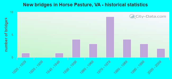
- New bridges - historical statistics
- 11920-1929
- 11940-1949
- 41950-1959
- 31960-1969
- 91970-1979
- 41980-1989
- 31990-1999
- 22000-2009


- Bridge Condition - Deck
- 5.9%Excellent
- 5.9%Very good
- 47.1%Good
- 41.2%Satisfactory

- Bridge Condition - Superstructure
- 5.9%Excellent
- 11.8%Very good
- 47.1%Good
- 29.4%Satisfactory
- 5.9%Fair

- Bridge Condition - Substructure
- 5.9%Very good
- 58.8%Good
- 23.5%Satisfactory
- 11.8%Fair

- Bridge Condition - Channel
- 31.3%Very good
- 31.3%Good
- 18.8%Satisfactory
- 12.5%Fair
- 6.3%Poor

- Bridge Condition - Culverts
- 75.0%Satisfactory
- 25.0%Fair
Find on map >> Show street view
Structure Number: 10044, Location: .10-Rte877; 0.0-Rte875 (Lat: 36.643892, Lng: -79.919714), Route carried "on" structure: US 58, Year Built: 1949, Status: Open, Structure Length: 0.88m (2.89ft), Average Daily Traffic: 9,460 (year 2020), Truck Traffic: 7%, Average Future Daily Traffic: 10,406 (year 2040), Design Load: HS 20, Features Intersected: Grassy Creek
Minimum Vertical Clearance: 30+ m (98+ ft), Kilometerpoint: 421.357, Lanes on structure: 4, Base Highway Network: Yes, Owner: State Highway Agency, Approaching Roadway Width: 18.3m (60.0ft), Skew: 9 degrees, Material/Design: Concrete, Design/Construction: Culvert, Number Of Spans In Main Unit: 2, Length of Maximum Span: 4.3m (14.1ft)
Condition: Channel: Fair, Culverts: Satisfactory, Operating Rating: 54.4 metric tons, Method Used To Determine Operating Rating: Load Factor (LF), Inventory Rating: 32.7 metric tons, Method Used To Determine Inventory Rating: Load Factor (LF), Structural Evaluation: Equal to present minimum criteria, Waterway Adequacy: Somewhat better than minimum adequacy, Approach Roadway Alignment: Equal to present desirable criteria, Length Of Structure Improvement: 0.88m (2.89ft), Designated Inspection Frequency: Every 24 months, Inspection Date: July 2021, Bridge Improvement Cost: $774,000, Roadway Improvement Cost: $271,000, Total Project Cost: $2,592,000 ( Estimate for 2020)
Find on map >> Show street view
Structure Number: 10046, Location: .4-Rte. 876; .2-Rte. 602 (Lat: 36.653144, Lng: -79.894464), Route carried "on" structure: Business US 58, Year Built: 1950, Status: Open, Structure Length: 0.99m (3.25ft), Average Daily Traffic: 7,258 (year 2020), Truck Traffic: 2%, Average Future Daily Traffic: 7,984 (year 2040), Design Load: HS 20, Features Intersected: Preston Branch
Minimum Vertical Clearance: 30+ m (98+ ft), Kilometerpoint: 2.142, Lanes on structure: 4, Base Highway Network: Yes, Owner: State Highway Agency, Approaching Roadway Width: 14.6m (47.9ft), Skew: 23 degrees, Material/Design: Concrete, Design/Construction: Culvert, Number Of Spans In Main Unit: 3, Length of Maximum Span: 3.2m (10.5ft)
Condition: Channel: Poor, Culverts: Fair, Operating Rating: 54.4 metric tons, Method Used To Determine Operating Rating: Field evaluation and documented engineering judgment, Inventory Rating: 32.7 metric tons, Method Used To Determine Inventory Rating: Field evaluation and documented engineering judgment, Structural Evaluation: Somewhat better than minimum adequacy, Waterway Adequacy: Meets minimum limits, Approach Roadway Alignment: Equal to present desirable criteria, Length Of Structure Improvement: 0.99m (3.25ft), Designated Inspection Frequency: Every 12 months, Inspection Date: July 2021, Bridge Improvement Cost: $1,293,000, Roadway Improvement Cost: $452,000, Total Project Cost: $4,330,000 ( Estimate for 2020)
Find on map >> Show street view
Structure Number: 10083, Location: 7.78-220B&57;2.35-220 BUS (Lat: 36.648200, Lng: -79.914894), Route carried "on" structure: Bypass US 220, Year Built: 1976, Status: Open, Structure Length: 7.35m (24.11ft), Average Daily Traffic: 6,758 (year 2020), Truck Traffic: 16%, Average Future Daily Traffic: 9,461 (year 2040), Design Load: HS 20+Mod, Features Intersected: RTE 58
Minimum Vertical Clearance: 30+ m (98+ ft), Kilometerpoint: 16.790, Lanes on structure: 2, Lanes under structure: 6, Base Highway Network: Yes, Owner: State Highway Agency, Approaching Roadway Width: 9.8m (32.2ft), Material/Design: Steel continuous, Design/Construction: Stringer/Multi-beam, Number Of Spans In Main Unit: 2, Number Of Approach Spans: 2, Length of Maximum Span: 26.2m (86.0ft), Curb-To-Curb Width: 11.6m (38.1ft), Out-to-Out Width: 12.8m (42.0ft)
Condition: Deck: Satisfactory, Superstructure: Satisfactory, Substructure: Satisfactory, Operating Rating: 73.5 metric tons, Method Used To Determine Operating Rating: Load and Resistance Factor (LRFR), Inventory Rating: 56.2 metric tons, Method Used To Determine Inventory Rating: Load and Resistance Factor (LRFR), Structural Evaluation: Equal to present minimum criteria, Deck Geometry: Equal to present minimum criteria, Underclear: Better than present minimum criteria, Approach Roadway Alignment: Equal to present desirable criteria, Designated Inspection Frequency: Every 24 months, Inspection Date: March 2020, Deck Structure Type: Concrete Cast-file-Place, Wearing Surface/Protective System: Wearing Surface: Latex Concrete
Find on map >> Show street view
Structure Number: 10085, Location: 7.87-57&220B :2.35-220 BS (Lat: 36.648378, Lng: -79.914703), Route carried "on" structure: Bypass US 220, Year Built: 1976, Status: Open, Structure Length: 7.37m (24.18ft), Average Daily Traffic: 6,758 (year 2020), Truck Traffic: 16%, Average Future Daily Traffic: 9,461 (year 2040), Design Load: HS 20+Mod, Features Intersected: RTE 58
Minimum Vertical Clearance: 30+ m (98+ ft), Kilometerpoint: 16.790, Lanes on structure: 3, Lanes under structure: 6, Base Highway Network: Yes, Owner: State Highway Agency, Approaching Roadway Width: 13.4m (44.0ft), Skew: 1 degrees, Material/Design: Steel continuous, Design/Construction: Stringer/Multi-beam, Number Of Spans In Main Unit: 2, Number Of Approach Spans: 2, Length of Maximum Span: 26.2m (86.0ft), Curb-To-Curb Width: 15.2m (49.9ft), Out-to-Out Width: 16.5m (54.1ft)
Condition: Deck: Satisfactory, Superstructure: Satisfactory, Substructure: Fair, Operating Rating: 72.6 metric tons, Method Used To Determine Operating Rating: Load and Resistance Factor (LRFR), Inventory Rating: 56.2 metric tons, Method Used To Determine Inventory Rating: Load and Resistance Factor (LRFR), Structural Evaluation: Somewhat better than minimum adequacy, Deck Geometry: Meets minimum limits, Underclear: Better than present minimum criteria, Approach Roadway Alignment: Equal to present desirable criteria, Designated Inspection Frequency: Every 24 months, Inspection Date: March 2020, Deck Structure Type: Concrete Cast-file-Place, Wearing Surface/Protective System: Wearing Surface: Epoxy Overlay
Find on map >> Show street view
Structure Number: 10096, Location: 0.03-Rte58; 0.78-End Mt (Lat: 36.656275, Lng: -79.892414), Route carried "on" structure: County highway 602, Year Built: 1985, Status: Open, Structure Length: 0.61m (2.00ft), Average Daily Traffic: 112 (year 2018), Average Future Daily Traffic: 124 (year 2040), Design Load: H 20, Features Intersected: Preston Branch
Minimum Vertical Clearance: 30+ m (98+ ft), Kilometerpoint: 0.048, Lanes on structure: 2, Owner: State Highway Agency, Approaching Roadway Width: 6.1m (20.0ft), Material/Design: Steel, Design/Construction: Culvert, Number Of Spans In Main Unit: 2, Length of Maximum Span: 2.7m (8.9ft)
Condition: Channel: Good, Culverts: Satisfactory, Operating Rating: 89.8 metric tons, Method Used To Determine Operating Rating: Field evaluation and documented engineering judgment, Inventory Rating: 89.8 metric tons, Method Used To Determine Inventory Rating: Field evaluation and documented engineering judgment, Structural Evaluation: Equal to present minimum criteria, Waterway Adequacy: Better than present minimum criteria, Approach Roadway Alignment: Equal to present desirable criteria, Length Of Structure Improvement: 0.61m (2.00ft), Designated Inspection Frequency: Every 24 months, Inspection Date: January 2022, Bridge Improvement Cost: $302,000, Roadway Improvement Cost: $76,000, Total Project Cost: $968,000 ( Estimate for 2022)
Find on map >> Show street view
Structure Number: 10115, Location: 1.80 Rt 695; 0.95 Rt 693 (Lat: 36.568022, Lng: -79.986336), Route carried "on" structure: County highway 629, Year Built: 1960, Status: Open, Structure Length: 6.71m (22.01ft), Average Daily Traffic: 76 (year 2018), Average Future Daily Traffic: 84 (year 2040), Design Load: HS 15, Features Intersected: North Mayo River
Minimum Vertical Clearance: 30+ m (98+ ft), Kilometerpoint: 8.206, Lanes on structure: 2, Owner: State Highway Agency, Approaching Roadway Width: 5.5m (18.0ft), Skew: 2 degrees, Material/Design: Steel, Design/Construction: Stringer/Multi-beam, Number Of Spans In Main Unit: 3, Length of Maximum Span: 22.6m (74.1ft), Curb or Sidewalk Widths: Left: 0.5m (1.6ft), Right: 0.5m (1.6ft), Curb-To-Curb Width: 7.3m (24.0ft), Out-to-Out Width: 8.3m (27.2ft)
Condition: Deck: Satisfactory, Superstructure: Good, Substructure: Satisfactory, Channel: Good, Operating Rating: 49.9 metric tons, Method Used To Determine Operating Rating: Load and Resistance Factor (LRFR), Inventory Rating: 38.1 metric tons, Method Used To Determine Inventory Rating: Load and Resistance Factor (LRFR), Structural Evaluation: Equal to present minimum criteria, Deck Geometry: Equal to present minimum criteria, Waterway Adequacy: Better than present minimum criteria, Approach Roadway Alignment: Equal to present minimum criteria, Length Of Structure Improvement: 6.71m (22.01ft), Designated Inspection Frequency: Every 24 months, Inspection Date: Febuary 2022, Bridge Improvement Cost: $3,311,000, Roadway Improvement Cost: $828,000, Total Project Cost: $10,594,000 ( Estimate for 2022), Deck Structure Type: Concrete Cast-file-Place, Wearing Surface/Protective System: Wearing Surface: Epoxy Overlay
Find on map >> Show street view
Structure Number: 10116, Location: 0.30 Rt 58E; 1.13 Rt 58W (Lat: 36.611228, Lng: -80.030922), Route carried "on" structure: County highway 630, Year Built: 1922, Status: Open, Structure Length: 4.08m (13.39ft), Average Daily Traffic: 82 (year 2018), Average Future Daily Traffic: 99 (year 2040), Features Intersected: North Mayo River
Minimum Vertical Clearance: 30+ m (98+ ft), Kilometerpoint: 0.483, Lanes on structure: 1, Owner: State Highway Agency, Approaching Roadway Width: 4.3m (14.1ft), Material/Design: Prestressed concrete, Design/Construction: Box Beam or Girders - Multiple, Number Of Spans In Main Unit: 1, Number Of Approach Spans: 2, Length of Maximum Span: 22.7m (74.5ft), Curb or Sidewalk Widths: Left: 0.1m (0.3ft), Right: 0.1m (0.3ft), Curb-To-Curb Width: 4.7m (15.4ft), Out-to-Out Width: 4.7m (15.4ft)
Condition: Deck: Very good, Superstructure: Very good, Substructure: Satisfactory, Channel: Very good, Operating Rating: 60.8 metric tons, Method Used To Determine Operating Rating: Load and Resistance Factor (LRFR), Inventory Rating: 47.2 metric tons, Method Used To Determine Inventory Rating: Load and Resistance Factor (LRFR), Structural Evaluation: Equal to present minimum criteria, Deck Geometry: Better than present minimum criteria, Waterway Adequacy: Better than present minimum criteria, Approach Roadway Alignment: Equal to present desirable criteria, Length Of Structure Improvement: 4.08m (13.39ft), Designated Inspection Frequency: Every 24 months, Inspection Date: October 2020, Bridge Improvement Cost: $1,251,000, Roadway Improvement Cost: $313,000, Total Project Cost: $4,004,000 ( Estimate for 2020), Wearing Surface/Protective System: Wearing Surface: Bituminous
Find on map >> Show street view
Structure Number: 10122, Location: 0.65 Rt 686; 0.20 Rt 685 (Lat: 36.628822, Lng: -79.880875), Route carried "on" structure: County highway 641, Year Built: 1977, Status: Open, Structure Length: 6.34m (20.80ft), Average Daily Traffic: 2,461 (year 2020), Truck Traffic: 5%, Average Future Daily Traffic: 3,445 (year 2040), Features Intersected: 58 & 220
Minimum Vertical Clearance: 30+ m (98+ ft), Kilometerpoint: 3.686, Lanes on structure: 2, Lanes under structure: 6, Owner: State Highway Agency, Approaching Roadway Width: 7.3m (24.0ft), Skew: 1 degrees, Material/Design: Steel continuous, Design/Construction: Stringer/Multi-beam, Number Of Spans In Main Unit: 2, Length of Maximum Span: 33.2m (108.9ft), Curb-To-Curb Width: 8.5m (27.9ft), Out-to-Out Width: 9.8m (32.2ft)
Condition: Deck: Good, Superstructure: Good, Substructure: Good, Operating Rating: 72.6 metric tons, Method Used To Determine Operating Rating: Load and Resistance Factor (LRFR), Inventory Rating: 56.2 metric tons, Method Used To Determine Inventory Rating: Load and Resistance Factor (LRFR), Structural Evaluation: Better than present minimum criteria, Deck Geometry: Meets minimum limits, Underclear: Somewhat better than minimum adequacy, Approach Roadway Alignment: Equal to present minimum criteria, Length Of Structure Improvement: 6.71m (22.01ft), Designated Inspection Frequency: Every 24 months, Inspection Date: January 2021, Bridge Improvement Cost: $4,326,000, Roadway Improvement Cost: $1,082,000, Total Project Cost: $13,844,000 ( Estimate for 2019), Deck Structure Type: Concrete Cast-file-Place, Wearing Surface/Protective System: Wearing Surface: Epoxy Overlay
Find on map >> Show street view
Structure Number: 1016, Location: 1.30-Rte692; 0.60-Rte781 (Lat: 36.580814, Lng: -79.926803), Route carried "on" structure: County highway 688, Year Built: 1983, Status: Open, Structure Length: 0.98m (3.22ft), Average Daily Traffic: 285 (year 2020), Truck Traffic: 5%, Average Future Daily Traffic: 306 (year 2040), Features Intersected: Marrowbone Creek
Minimum Vertical Clearance: 30+ m (98+ ft), Kilometerpoint: 8.245, Lanes on structure: 2, Owner: State Highway Agency, Approaching Roadway Width: 5.5m (18.0ft), Material/Design: Concrete, Design/Construction: Slab, Number Of Spans In Main Unit: 1, Length of Maximum Span: 9.1m (29.9ft), Curb or Sidewalk Widths: Left: 0.5m (1.6ft), Right: 0.5m (1.6ft), Curb-To-Curb Width: 8.1m (26.6ft), Out-to-Out Width: 9.1m (29.9ft)
Condition: Deck: Satisfactory, Superstructure: Satisfactory, Substructure: Good, Channel: Very good, Operating Rating: 89.8 metric tons, Method Used To Determine Operating Rating: Load and Resistance Factor (LRFR), Inventory Rating: 88.9 metric tons, Method Used To Determine Inventory Rating: Load and Resistance Factor (LRFR), Structural Evaluation: Equal to present minimum criteria, Deck Geometry: Somewhat better than minimum adequacy, Waterway Adequacy: Equal to present minimum criteria, Approach Roadway Alignment: Meets minimum limits, Length Of Structure Improvement: 0.98m (3.22ft), Designated Inspection Frequency: Every 24 months, Inspection Date: January 2022, Bridge Improvement Cost: $512,000, Roadway Improvement Cost: $128,000, Total Project Cost: $1,638,000 ( Estimate for 2020), Deck Structure Type: Concrete Cast-file-Place, Wearing Surface/Protective System: Deck Protection: Epoxy Coated Reinforcing
Find on map >> Show street view
Structure Number: 10161, Location: 0.27 Rt 695; 3.05 Rt 692 (Lat: 36.585567, Lng: -79.994739), Route carried "on" structure: County highway 688, Year Built: 1966, Status: Open, Structure Length: 1.25m (4.10ft), Average Daily Traffic: 211 (year 2018), Average Future Daily Traffic: 234 (year 2040), Design Load: HS 20+Mod, Features Intersected: Horse Pasture Creek
Minimum Vertical Clearance: 30+ m (98+ ft), Kilometerpoint: 0.422, Lanes on structure: 2, Owner: State Highway Agency, Approaching Roadway Width: 5.5m (18.0ft), Skew: 1 degrees, Material/Design: Concrete, Design/Construction: Box Beam or Girders - Multiple, Number Of Spans In Main Unit: 1, Length of Maximum Span: 11.5m (37.7ft), Curb or Sidewalk Widths: Left: 0.1m (0.3ft), Right: 0.1m (0.3ft), Curb-To-Curb Width: 7.3m (24.0ft), Out-to-Out Width: 7.7m (25.3ft)
Condition: Deck: Excellent, Superstructure: Excellent, Substructure: Very good, Channel: Very good, Operating Rating: 59.9 metric tons, Method Used To Determine Operating Rating: Load and Resistance Factor (LRFR), Inventory Rating: 46.3 metric tons, Method Used To Determine Inventory Rating: Load and Resistance Factor (LRFR), Structural Evaluation: Equal to present desirable criteria, Deck Geometry: Somewhat better than minimum adequacy, Waterway Adequacy: Somewhat better than minimum adequacy, Approach Roadway Alignment: Equal to present minimum criteria, Length Of Structure Improvement: 1.25m (4.10ft), Designated Inspection Frequency: Every 24 months, Inspection Date: October 2021, Bridge Improvement Cost: $659,000, Roadway Improvement Cost: $165,000, Total Project Cost: $2,109,000 ( Estimate for 2020), Wearing Surface/Protective System: Wearing Surface: Bituminous
Find on map >> Show street view
Structure Number: 10165, Location: 0.30-Rte698; 0.25-Rte972 (Lat: 36.631603, Lng: -80.005247), Route carried "on" structure: County highway 695, Year Built: 1957, Status: Open, Structure Length: 1.68m (5.51ft), Average Daily Traffic: 297 (year 2020), Truck Traffic: 4%, Average Future Daily Traffic: 327 (year 2040), Design Load: HS 15, Features Intersected: Horse Pasture Creek
Minimum Vertical Clearance: 30+ m (98+ ft), Kilometerpoint: 15.092, Lanes on structure: 2, Owner: State Highway Agency, Approaching Roadway Width: 5.5m (18.0ft), Skew: 3 degrees, Material/Design: Steel, Design/Construction: Stringer/Multi-beam, Number Of Spans In Main Unit: 1, Length of Maximum Span: 15.0m (49.2ft), Curb or Sidewalk Widths: Left: 0.8m (2.6ft), Right: 0.8m (2.6ft), Curb-To-Curb Width: 7.3m (24.0ft), Out-to-Out Width: 8.8m (28.9ft)
Condition: Deck: Good, Superstructure: Satisfactory, Substructure: Good, Channel: Very good, Operating Rating: 49.0 metric tons, Method Used To Determine Operating Rating: Load and Resistance Factor (LRFR), Inventory Rating: 37.2 metric tons, Method Used To Determine Inventory Rating: Load and Resistance Factor (LRFR), Structural Evaluation: Equal to present minimum criteria, Deck Geometry: Somewhat better than minimum adequacy, Waterway Adequacy: Somewhat better than minimum adequacy, Approach Roadway Alignment: Equal to present desirable criteria, Length Of Structure Improvement: 1.68m (5.51ft), Designated Inspection Frequency: Every 24 months, Inspection Date: March 2020, Bridge Improvement Cost: $880,000, Roadway Improvement Cost: $220,000, Total Project Cost: $2,815,000 ( Estimate for 2020), Deck Structure Type: Concrete Cast-file-Place, Wearing Surface/Protective System: Wearing Surface: Epoxy Overlay
Find on map >> Show street view
Structure Number: 10166, Location: 0.39 Rt 688; 1.90 Rt 629 (Lat: 36.583511, Lng: -80.001850), Route carried "on" structure: County highway 695, Year Built: 1958, Status: Open, Structure Length: 5.78m (18.96ft), Average Daily Traffic: 269 (year 2015), Average Future Daily Traffic: 303 (year 2040), Design Load: HS 15, Features Intersected: North Mayo River
Minimum Vertical Clearance: 30+ m (98+ ft), Kilometerpoint: 8.198, Lanes on structure: 2, Owner: State Highway Agency, Approaching Roadway Width: 5.5m (18.0ft), Material/Design: Steel, Design/Construction: Stringer/Multi-beam, Number Of Spans In Main Unit: 3, Length of Maximum Span: 19.1m (62.7ft), Curb or Sidewalk Widths: Left: 0.5m (1.6ft), Right: 0.5m (1.6ft), Curb-To-Curb Width: 7.3m (24.0ft), Out-to-Out Width: 8.3m (27.2ft)
Condition: Deck: Good, Superstructure: Good, Substructure: Good, Channel: Satisfactory, Operating Rating: 46.3 metric tons, Method Used To Determine Operating Rating: Load and Resistance Factor (LRFR), Inventory Rating: 35.4 metric tons, Method Used To Determine Inventory Rating: Load and Resistance Factor (LRFR), Structural Evaluation: Better than present minimum criteria, Deck Geometry: Somewhat better than minimum adequacy, Waterway Adequacy: Better than present minimum criteria, Approach Roadway Alignment: Equal to present desirable criteria, Length Of Structure Improvement: 5.78m (18.96ft), Designated Inspection Frequency: Every 24 months, Inspection Date: Febuary 2020, Bridge Improvement Cost: $3,039,000, Roadway Improvement Cost: $760,000, Total Project Cost: $9,725,000 ( Estimate for 2020), Deck Structure Type: Concrete Cast-file-Place, Wearing Surface/Protective System: Wearing Surface: Epoxy Overlay
Find on map >> Show street view
Structure Number: 10167, Location: 0.94 Rt 629; 0.85 Rt 631 (Lat: 36.555589, Lng: -80.021575), Route carried "on" structure: County highway 695, Year Built: 1958, Status: Open, Structure Length: 5.78m (18.96ft), Average Daily Traffic: 227 (year 2015), Average Future Daily Traffic: 273 (year 2040), Design Load: HS 15, Features Intersected: South Mayo River
Minimum Vertical Clearance: 30+ m (98+ ft), Kilometerpoint: 2.245, Lanes on structure: 2, Owner: State Highway Agency, Approaching Roadway Width: 5.5m (18.0ft), Material/Design: Steel, Design/Construction: Stringer/Multi-beam, Number Of Spans In Main Unit: 3, Length of Maximum Span: 18.7m (61.4ft), Curb or Sidewalk Widths: Left: 0.5m (1.6ft), Right: 0.5m (1.6ft), Curb-To-Curb Width: 7.3m (24.0ft), Out-to-Out Width: 8.3m (27.2ft)
Condition: Deck: Satisfactory, Superstructure: Satisfactory, Substructure: Good, Channel: Good, Operating Rating: 46.3 metric tons, Method Used To Determine Operating Rating: Load and Resistance Factor (LRFR), Inventory Rating: 35.4 metric tons, Method Used To Determine Inventory Rating: Load and Resistance Factor (LRFR), Structural Evaluation: Equal to present minimum criteria, Deck Geometry: Somewhat better than minimum adequacy, Waterway Adequacy: Better than present minimum criteria, Approach Roadway Alignment: Equal to present desirable criteria, Length Of Structure Improvement: 5.78m (18.96ft), Designated Inspection Frequency: Every 24 months, Inspection Date: Febuary 2022, Bridge Improvement Cost: $2,857,000, Roadway Improvement Cost: $714,000, Total Project Cost: $9,141,000 ( Estimate for 2020), Deck Structure Type: Concrete Cast-file-Place
Find on map >> Show street view
Structure Number: 10171, Location: 0.12-Rte58; 0.05-end Main (Lat: 36.616272, Lng: -80.033381), Route carried "on" structure: County highway 699, Year Built: 1966, Status: Posted for load, Structure Length: 1.68m (5.51ft), Average Daily Traffic: 10 (year 2015), Average Future Daily Traffic: 12 (year 2040), Features Intersected: North Mayo River
Minimum Vertical Clearance: 30+ m (98+ ft), Kilometerpoint: 0.177, Lanes on structure: 1, Base Highway Network: Yes, Owner: State Highway Agency, Approaching Roadway Width: 3.0m (9.8ft), Material/Design: Steel, Design/Construction: Stringer/Multi-beam, Number Of Spans In Main Unit: 1, Length of Maximum Span: 16.0m (52.5ft), Curb or Sidewalk Widths: Left: 0.2m (0.7ft), Right: 0.2m (0.7ft), Curb-To-Curb Width: 3.4m (11.2ft), Out-to-Out Width: 3.6m (11.8ft)
Condition: Deck: Satisfactory, Superstructure: Fair, Substructure: Fair, Channel: Fair, Operating Rating: 22.7 metric tons, Method Used To Determine Operating Rating: Load Factor (LF), Inventory Rating: 13.6 metric tons, Method Used To Determine Inventory Rating: Load Factor (LF), Structural Evaluation: Meets minimum limits, Deck Geometry: High priority of corrective action, Waterway Adequacy: Equal to present minimum criteria, Approach Roadway Alignment: Equal to present minimum criteria, Bridge Posting: Required (Relationship of Operating Rating to Maximum Legal Load: > 39.9% below), Length Of Structure Improvement: 1.68m (5.51ft), Designated Inspection Frequency: Every 24 months, Inspection Date: August 2021, Bridge Improvement Cost: $510,000, Roadway Improvement Cost: $128,000, Total Project Cost: $1,633,000 ( Estimate for 2021), Deck Structure Type: Wood or Timber
Find on map >> Show street view
Structure Number: 10178, Location: 1.85 Rt 58 &0.40 RT 781 (Lat: 36.642761, Lng: -79.900589), Route carried "on" structure: County highway 752, Year Built: 1977, Status: Open, Structure Length: 4.75m (15.58ft), Average Daily Traffic: 764 (year 2018), Average Future Daily Traffic: 848 (year 2040), Features Intersected: RTES 58EB & 220SB
Minimum Vertical Clearance: 30+ m (98+ ft), Kilometerpoint: 0.597, Lanes on structure: 2, Lanes under structure: 2, Owner: State Highway Agency, Approaching Roadway Width: 6.1m (20.0ft), Skew: 1 degrees, Material/Design: Steel, Design/Construction: Stringer/Multi-beam, Number Of Spans In Main Unit: 3, Length of Maximum Span: 21.8m (71.5ft), Curb-To-Curb Width: 7.9m (25.9ft), Out-to-Out Width: 9.1m (29.9ft)
Condition: Deck: Satisfactory, Superstructure: Good, Substructure: Good, Operating Rating: 74.4 metric tons, Method Used To Determine Operating Rating: Load and Resistance Factor (LRFR), Inventory Rating: 57.2 metric tons, Method Used To Determine Inventory Rating: Load and Resistance Factor (LRFR), Structural Evaluation: Better than present minimum criteria, Deck Geometry: Somewhat better than minimum adequacy, Underclear: Equal to present minimum criteria, Approach Roadway Alignment: Equal to present desirable criteria, Designated Inspection Frequency: Every 24 months, Inspection Date: January 2021, Deck Structure Type: Concrete Cast-file-Place, Wearing Surface/Protective System: Wearing Surface: Epoxy Overlay
Find on map >> Show street view
Structure Number: 10208, Location: 0.70 Rt 684; 0.10 Rt 1713 (Lat: 36.664989, Lng: -79.927525), Route carried "on" structure: County highway 1714, Year Built: 1983, Status: Posted for load, Structure Length: 6.04m (19.82ft), Average Daily Traffic: 718 (year 2015), Average Future Daily Traffic: 808 (year 2040), Design Load: HS 20+Mod, Features Intersected: 220 Bypass
Minimum Vertical Clearance: 30+ m (98+ ft), Kilometerpoint: 1.046, Lanes on structure: 2, Lanes under structure: 4, Owner: State Highway Agency, Approaching Roadway Width: 5.8m (19.0ft), Material/Design: Steel continuous, Design/Construction: Stringer/Multi-beam, Number Of Spans In Main Unit: 2, Length of Maximum Span: 30.2m (99.1ft), Curb-To-Curb Width: 9.3m (30.5ft), Out-to-Out Width: 10.3m (33.8ft)
Condition: Deck: Good, Superstructure: Good, Substructure: Satisfactory, Operating Rating: 47.2 metric tons, Method Used To Determine Operating Rating: Load and Resistance Factor (LRFR), Inventory Rating: 36.3 metric tons, Method Used To Determine Inventory Rating: Load and Resistance Factor (LRFR), Structural Evaluation: Equal to present minimum criteria, Deck Geometry: Equal to present minimum criteria, Underclear: Somewhat better than minimum adequacy, Approach Roadway Alignment: Equal to present desirable criteria, Designated Inspection Frequency: Every 24 months, Inspection Date: August 2020, Deck Structure Type: Concrete Cast-file-Place, Wearing Surface/Protective System: Deck Protection: Epoxy Coated Reinforcing
Find on map >> Show street view
Structure Number: 23494, Location: 0.01-RT 58; 0.05-RT 829 (Lat: 36.645311, Lng: -79.920178), Route carried "on" structure: County highway 875, Year Built: 1992, Status: Open, Structure Length: 0.64m (2.10ft), Average Daily Traffic: 203 (year 2018), Average Future Daily Traffic: 278 (year 2040), Design Load: HS 20, Features Intersected: Grassy Creek
Minimum Vertical Clearance: 30+ m (98+ ft), Kilometerpoint: 0.161, Lanes on structure: 2, Owner: State Highway Agency, Approaching Roadway Width: 6.1m (20.0ft), Material/Design: Concrete, Design/Construction: Culvert, Number Of Spans In Main Unit: 2, Length of Maximum Span: 3.0m (9.8ft)
Condition: Channel: Satisfactory, Culverts: Satisfactory, Operating Rating: 73.5 metric tons, Method Used To Determine Operating Rating: Load Factor (LF), Inventory Rating: 43.5 metric tons, Method Used To Determine Inventory Rating: Load Factor (LF), Structural Evaluation: Equal to present minimum criteria, Waterway Adequacy: Better than present minimum criteria, Approach Roadway Alignment: Equal to present minimum criteria, Length Of Structure Improvement: 0.64m (2.10ft), Designated Inspection Frequency: Every 24 months, Inspection Date: September 2020, Bridge Improvement Cost: $302,000, Roadway Improvement Cost: $76,000, Total Project Cost: $983,000 ( Estimate for 2020)
Find on map >> Show street view
Structure Number: 24096, Location: 0.18 RT 759; 0.63 Rt 695 (Lat: 36.622492, Lng: -79.996983), Route carried "on" structure: US 58, Year Built: 1994, Status: Open, Structure Length: 3.35m (10.99ft), Average Daily Traffic: 3,425 (year 2020), Truck Traffic: 7%, Average Future Daily Traffic: 4,796 (year 2040), Design Load: HS 20+Mod, Features Intersected: Horse Pasture Creek
Minimum Vertical Clearance: 30+ m (98+ ft), Kilometerpoint: 413.610, Lanes on structure: 2, Base Highway Network: Yes, Owner: State Highway Agency, Approaching Roadway Width: 7.3m (24.0ft), Skew: 1 degrees, Material/Design: Steel continuous, Design/Construction: Stringer/Multi-beam, Number Of Spans In Main Unit: 3, Length of Maximum Span: 15.2m (49.9ft), Curb or Sidewalk Widths: Left: 0.5m (1.6ft), Right: 0.5m (1.6ft), Curb-To-Curb Width: 12.2m (40.0ft), Out-to-Out Width: 13.2m (43.3ft)
Condition: Deck: Good, Superstructure: Very good, Substructure: Good, Channel: Very good, Operating Rating: 89.8 metric tons, Method Used To Determine Operating Rating: Load and Resistance Factor (LRFR), Inventory Rating: 82.6 metric tons, Method Used To Determine Inventory Rating: Load and Resistance Factor (LRFR), Structural Evaluation: Better than present minimum criteria, Deck Geometry: Better than present minimum criteria, Waterway Adequacy: Equal to present desirable criteria, Approach Roadway Alignment: Equal to present desirable criteria, Length Of Structure Improvement: 3.35m (10.99ft), Designated Inspection Frequency: Every 24 months, Inspection Date: November 2021, Bridge Improvement Cost: $2,497,000, Roadway Improvement Cost: $874,000, Total Project Cost: $8,240,000 ( Estimate for 2021), Deck Structure Type: Concrete Cast-file-Place, Wearing Surface/Protective System: Wearing Surface: Epoxy Overlay, Deck Protection: Epoxy Coated Reinforcing
Find on map >> Show street view
Structure Number: 24414, Location: 0.18-Rte759; 0.63-Rte695 (Lat: 36.622289, Lng: -79.996969), Route carried "on" structure: US 58, Year Built: 1995, Status: Open, Structure Length: 3.35m (10.99ft), Average Daily Traffic: 3,425 (year 2020), Truck Traffic: 7%, Average Future Daily Traffic: 4,796 (year 2040), Design Load: HS 20+Mod, Features Intersected: Horse Pasture Creek
Minimum Vertical Clearance: 30+ m (98+ ft), Kilometerpoint: 413.610, Lanes on structure: 2, Base Highway Network: Yes, Owner: State Highway Agency, Approaching Roadway Width: 7.3m (24.0ft), Skew: 1 degrees, Material/Design: Steel continuous, Design/Construction: Stringer/Multi-beam, Number Of Spans In Main Unit: 3, Length of Maximum Span: 15.2m (49.9ft), Curb or Sidewalk Widths: Left: 0.5m (1.6ft), Right: 0.5m (1.6ft), Curb-To-Curb Width: 12.2m (40.0ft), Out-to-Out Width: 13.1m (43.0ft)
Condition: Deck: Good, Superstructure: Good, Substructure: Good, Channel: Good, Operating Rating: 89.8 metric tons, Method Used To Determine Operating Rating: Load and Resistance Factor (LRFR), Inventory Rating: 82.6 metric tons, Method Used To Determine Inventory Rating: Load and Resistance Factor (LRFR), Structural Evaluation: Better than present minimum criteria, Deck Geometry: Better than present minimum criteria, Waterway Adequacy: Equal to present desirable criteria, Approach Roadway Alignment: Equal to present desirable criteria, Length Of Structure Improvement: 3.35m (10.99ft), Designated Inspection Frequency: Every 24 months, Inspection Date: November 2021, Bridge Improvement Cost: $2,499,000, Roadway Improvement Cost: $875,000, Total Project Cost: $8,247,000 ( Estimate for 2021), Deck Structure Type: Concrete Cast-file-Place, Wearing Surface/Protective System: Deck Protection: Epoxy Coated Reinforcing
Find on map >> Show street view
Structure Number: 25597, Location: 0.60-Rt 630; 0.20-Rt 699 (Lat: 36.613469, Lng: -80.035883), Route carried "on" structure: US 58, Year Built: 2001, Status: Open, Structure Length: 5.62m (18.44ft), Average Daily Traffic: 2,746 (year 2020), Truck Traffic: 7%, Average Future Daily Traffic: 3,844 (year 2040), Design Load: HS 20+Mod, Features Intersected: North Mayo River, Facility Carried by Structure: A L Philptt HWY
Minimum Vertical Clearance: 30+ m (98+ ft), Kilometerpoint: 409.957, Lanes on structure: 2, Base Highway Network: Yes, Owner: State Highway Agency, Approaching Roadway Width: 7.3m (24.0ft), Skew: 1 degrees, Material/Design: Prestressed concrete continuous, Design/Construction: Stringer/Multi-beam, Number Of Spans In Main Unit: 3, Length of Maximum Span: 21.9m (71.9ft), Curb-To-Curb Width: 12.2m (40.0ft), Out-to-Out Width: 13.2m (43.3ft)
Condition: Deck: Good, Superstructure: Good, Substructure: Good, Channel: Satisfactory, Operating Rating: 71.7 metric tons, Method Used To Determine Operating Rating: Load and Resistance Factor (LRFR), Inventory Rating: 54.4 metric tons, Method Used To Determine Inventory Rating: Load and Resistance Factor (LRFR), Structural Evaluation: Better than present minimum criteria, Deck Geometry: Better than present minimum criteria, Waterway Adequacy: Equal to present desirable criteria, Approach Roadway Alignment: Equal to present desirable criteria, Designated Inspection Frequency: Every 24 months, Inspection Date: September 2020, Deck Structure Type: Concrete Cast-file-Place, Wearing Surface/Protective System: Deck Protection: Epoxy Coated Reinforcing
Find on map >> Show street view
Structure Number: 25599, Location: 0.60-Rt 630;0.20-Rt 699 (Lat: 36.613347, Lng: -80.035708), Route carried "on" structure: US 58, Year Built: 2000, Status: Open, Structure Length: 5.47m (17.95ft), Average Daily Traffic: 2,746 (year 2020), Truck Traffic: 7%, Average Future Daily Traffic: 3,844 (year 2040), Design Load: HS 20+Mod, Features Intersected: North Mayo River
Minimum Vertical Clearance: 30+ m (98+ ft), Kilometerpoint: 409.925, Lanes on structure: 2, Base Highway Network: Yes, Owner: State Highway Agency, Approaching Roadway Width: 7.3m (24.0ft), Skew: 1 degrees, Material/Design: Prestressed concrete continuous, Design/Construction: Stringer/Multi-beam, Number Of Spans In Main Unit: 3, Length of Maximum Span: 21.9m (71.9ft), Curb-To-Curb Width: 12.2m (40.0ft), Out-to-Out Width: 13.2m (43.3ft)
Condition: Deck: Good, Superstructure: Good, Substructure: Good, Channel: Good, Operating Rating: 74.4 metric tons, Method Used To Determine Operating Rating: Load and Resistance Factor (LRFR), Inventory Rating: 57.2 metric tons, Method Used To Determine Inventory Rating: Load and Resistance Factor (LRFR), Structural Evaluation: Better than present minimum criteria, Deck Geometry: Better than present minimum criteria, Waterway Adequacy: Equal to present desirable criteria, Approach Roadway Alignment: Equal to present desirable criteria, Designated Inspection Frequency: Every 24 months, Inspection Date: September 2020, Deck Structure Type: Concrete Cast-file-Place, Wearing Surface/Protective System: Deck Protection: Epoxy Coated Reinforcing
Find on map >> Show street view
Structure Number: 10083, Location: 7.78-220B&57;2.35-220 BUS (Lat: 36.648200, Lng: -79.914894), Route carried "under" structure: US 58, Year Built: 1976, Structure Length: 0. m, Average Daily Traffic: 4,798 (year 2008), Truck Traffic: 2%, Features Intersected: RTE 58, Facility Carried by Structure: SBL ROUTE 0220
Minimum Vertical Clearance: 5.49m (18.01ft), Kilometerpoint: 0.080, Lanes on structure: 2, Lanes under structure: 6, Material/Design: Steel continuous, Design/Construction: Stringer/Multi-beam, Length of Maximum Span: 26.2m (86.0ft)
Find on map >> Show street view
Structure Number: 10085, Location: 7.87-57&220B :2.35-220 BS (Lat: 36.648378, Lng: -79.914703), Route carried "under" structure: US 58, Year Built: 1976, Structure Length: 0. m, Average Daily Traffic: 4,798 (year 2008), Truck Traffic: 2%, Features Intersected: RTE 58, Facility Carried by Structure: NBL ROUTE 0220
Minimum Vertical Clearance: 5.39m (17.68ft), Kilometerpoint: 0.113, Lanes on structure: 3, Lanes under structure: 6, Material/Design: Steel continuous, Design/Construction: Stringer/Multi-beam, Length of Maximum Span: 26.2m (86.0ft)
Find on map >> Show street view
Structure Number: 10122, Location: 0.65 Rt 686; 0.20 Rt 685 (Lat: 36.628822, Lng: -79.880875), Route carried "under" structure: Bypass US 58, Year Built: 1977, Structure Length: 0. m, Average Daily Traffic: 15,998 (year 2008), Truck Traffic: 15%, Features Intersected: 58 & 220, Facility Carried by Structure: JOSEPH MRTN HWY641
Minimum Vertical Clearance: 5.51m (18.08ft), Kilometerpoint: 12.920, Lanes on structure: 2, Lanes under structure: 6, Material/Design: Steel continuous, Design/Construction: Stringer/Multi-beam, Length of Maximum Span: 33.2m (108.9ft)
Find on map >> Show street view
Structure Number: 10178, Location: 1.85 Rt 58 &0.40 RT 781 (Lat: 36.642761, Lng: -79.900589), Route carried "under" structure: Bypass US 58, Year Built: 1977, Structure Length: 0. m, Average Daily Traffic: 15,998 (year 2008), Truck Traffic: 15%, Features Intersected: RTES 58EB & 220SB, Facility Carried by Structure: Cameron Rd 752
Minimum Vertical Clearance: 5.56m (18.24ft), Kilometerpoint: 15.286, Lanes on structure: 2, Lanes under structure: 2, Material/Design: Steel, Design/Construction: Stringer/Multi-beam, Length of Maximum Span: 21.8m (71.5ft)
Find on map >> Show street view
Structure Number: 1018, Location: 1.80 Rt 58; 0.45 Rt 781 (Lat: 36.643183, Lng: -79.899856), Route carried "under" structure: Bypass US 58, Year Built: 1977, Structure Length: 0. m, Average Daily Traffic: 15,998 (year 2008), Truck Traffic: 15%, Features Intersected: 58 WBL 220 NBL Bypass, Facility Carried by Structure: Cameron Rd 752
Minimum Vertical Clearance: 5.16m (16.93ft), Kilometerpoint: 15.286, Lanes on structure: 2, Lanes under structure: 2, Material/Design: Steel, Design/Construction: Stringer/Multi-beam, Length of Maximum Span: 21.8m (71.5ft)
Find on map >> Show street view
Structure Number: 10208, Location: 0.70 Rt 684; 0.10 Rt 1713 (Lat: 36.664989, Lng: -79.927525), Route carried "under" structure: Bypass US 220, Year Built: 1983, Structure Length: 0. m, Average Daily Traffic: 15,000 (year 2017), Truck Traffic: 15%, Features Intersected: 220 Bypass, Facility Carried by Structure: Parkway Drive 1714
Minimum Vertical Clearance: 6.83m (22.41ft), Kilometerpoint: 19.067, Lanes on structure: 2, Lanes under structure: 4, Material/Design: Steel continuous, Design/Construction: Stringer/Multi-beam, Length of Maximum Span: 30.2m (99.1ft)