Bridge Statistics for Horseheads, New York (NY)
Condition, Traffic, Stress, Structural Evaluation, Project Costs
- National Bridge Inventory (NBI) Statistics
- 40Number of bridges
- 344ft / 105mTotal length
- $87,564,000Total costs
- 362,698Total average daily traffic
- 43,855Total average daily truck traffic
- National Bridge Inventory (NBI) Registered Bridges for Horseheads
- No street view available for this location
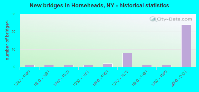
- New bridges - historical statistics
- 11920-1929
- 11930-1939
- 11940-1949
- 11950-1959
- 21960-1969
- 81970-1979
- 11980-1989
- 11990-1999
- 242000-2009
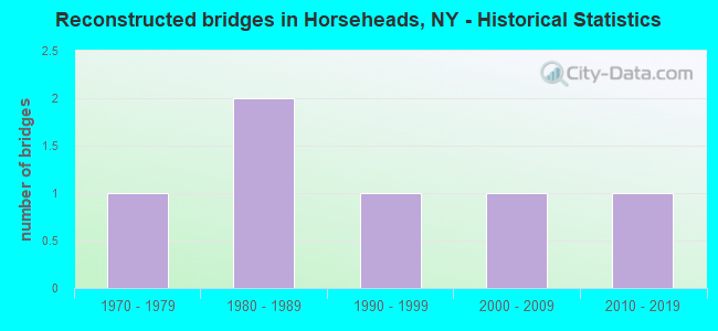
- Reconstructed bridges - Historical Statistics
- 11970-1979
- 21980-1989
- 11990-1999
- 12000-2009
- 12010-2019
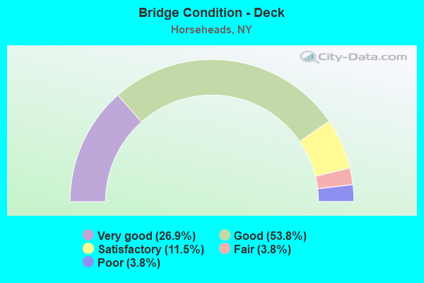
- Bridge Condition - Deck
- 26.9%Very good
- 53.8%Good
- 11.5%Satisfactory
- 3.8%Fair
- 3.8%Poor
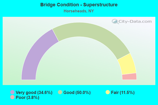
- Bridge Condition - Superstructure
- 34.6%Very good
- 50.0%Good
- 11.5%Fair
- 3.8%Poor
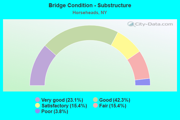
- Bridge Condition - Substructure
- 23.1%Very good
- 42.3%Good
- 15.4%Satisfactory
- 15.4%Fair
- 3.8%Poor
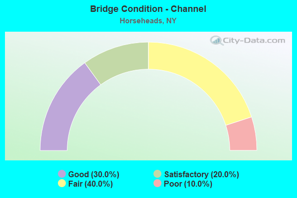
- Bridge Condition - Channel
- 30.0%Good
- 20.0%Satisfactory
- 40.0%Fair
- 10.0%Poor
Find on map >> Show street view
Structure Number: 10108, Location: 0.3 MI NW JCT RTS 17 +352 (Lat: 42.146506, Lng: -76.805908), Route carried "on" structure: Interstate 86, Year Built: 1955, Status: Open, Structure Length: 1.34m (4.40ft), Average Daily Traffic: 27,500 (year 2018), Truck Traffic: 14%, Average Future Daily Traffic: 42,215 (year 2040), Design Load: HS 20, Features Intersected: LATTA BROOK
Minimum Vertical Clearance: 30+ m (98+ ft), Kilometerpoint: 14.465, Lanes on structure: 5, Base Highway Network: Yes, Owner: State Highway Agency, Approaching Roadway Width: 25.6m (84.0ft), Skew: 31 degrees, Material/Design: Concrete, Design/Construction: Culvert, Number Of Spans In Main Unit: 2, Length of Maximum Span: 6.0m (19.7ft)
Condition: Channel: Fair, Culverts: Fair, Operating Rating: 59.0 metric tons, Method Used To Determine Operating Rating: Load Factor (LF), Inventory Rating: 35.4 metric tons, Method Used To Determine Inventory Rating: Load Factor (LF), Structural Evaluation: Somewhat better than minimum adequacy, Waterway Adequacy: Equal to present minimum criteria, Approach Roadway Alignment: Equal to present desirable criteria, Length Of Structure Improvement: 1.34m (4.40ft), Designated Inspection Frequency: Every 24 months, Inspection Date: April 2020, Bridge Improvement Cost: $1,022,000, Roadway Improvement Cost: $599,000, Total Project Cost: $1,621,000 ( Estimate for 2021), Wearing Surface/Protective System: Wearing Surface: Bituminous
Find on map >> Show street view
Structure Number: 104597, Location: .5 MI S JCT SR 17 & SR 14 (Lat: 42.156842, Lng: -76.837089), Route carried "on" structure: State highway 14, Year Built: 1985, Status: Open, Structure Length: 8.81m (28.90ft), Average Daily Traffic: 15,537 (year 2019), Truck Traffic: 4%, Average Future Daily Traffic: 15,610 (year 2040), Design Load: HS 20, Features Intersected: NORFOLK SOUTHERN
Minimum Vertical Clearance: 30+ m (98+ ft), Kilometerpoint: 20.676, Lanes on structure: 4, Base Highway Network: Yes, Owner: State Highway Agency, Approaching Roadway Width: 21.3m (69.9ft), Skew: 34 degrees, Material/Design: Prestressed concrete continuous, Design/Construction: Box Beam or Girders - Multiple, Number Of Spans In Main Unit: 3, Length of Maximum Span: 31.0m (101.7ft), Curb-To-Curb Width: 21.4m (70.2ft), Out-to-Out Width: 23.2m (76.1ft)
Condition: Deck: Good, Superstructure: Fair, Substructure: Fair, Operating Rating: 70.8 metric tons, Method Used To Determine Operating Rating: Load Factor (LF), Inventory Rating: 30.8 metric tons, Method Used To Determine Inventory Rating: Load Factor (LF), Structural Evaluation: Somewhat better than minimum adequacy, Deck Geometry: Superior to present desirable criteria, Underclear: Somewhat better than minimum adequacy, Approach Roadway Alignment: Equal to present desirable criteria, Length Of Structure Improvement: 8.80m (28.87ft), Designated Inspection Frequency: Every 24 months, Inspection Date: June 2021, Bridge Improvement Cost: $4,711,000, Roadway Improvement Cost: $2,759,000, Total Project Cost: $7,469,000 ( Estimate for 2021), Deck Structure Type: Concrete Cast-file-Place, Wearing Surface/Protective System: Wearing Surface: Bituminous
Find on map >> Show street view
Structure Number: 1053281, Location: JCT RTS 14 + 17 + 328 (Lat: 42.160614, Lng: -76.838369), Route carried "on" structure: Interstate 86, Year Built: 1970, Status: Open, Structure Length: 4.85m (15.91ft), Average Daily Traffic: 17,582 (year 2015), Truck Traffic: 18%, Design Load: HS 20+Mod, Features Intersected: RTE 14
Minimum Vertical Clearance: 30+ m (98+ ft), Kilometerpoint: 11.038, Lanes on structure: 3, Lanes under structure: 6, Base Highway Network: Yes, Owner: State Highway Agency, Approaching Roadway Width: 13.1m (43.0ft), Skew: 3 degrees, Material/Design: Steel, Design/Construction: Stringer/Multi-beam, Number Of Spans In Main Unit: 1, Length of Maximum Span: 45.7m (149.9ft), Curb-To-Curb Width: 13.9m (45.6ft), Out-to-Out Width: 14.8m (48.6ft)
Condition: Deck: Satisfactory, Superstructure: Good, Substructure: Satisfactory, Operating Rating: 77.1 metric tons, Method Used To Determine Operating Rating: Load Factor (LF), Inventory Rating: 46.3 metric tons, Method Used To Determine Inventory Rating: Load Factor (LF), Structural Evaluation: Equal to present minimum criteria, Deck Geometry: Meets minimum limits, Underclear: High priority of corrective action, Approach Roadway Alignment: Equal to present desirable criteria, Length Of Structure Improvement: 4.84m (15.88ft), Designated Inspection Frequency: Every 24 months, Inspection Date: September 2020, Bridge Improvement Cost: $2,529,000, Roadway Improvement Cost: $1,481,000, Total Project Cost: $4,010,000 ( Estimate for 2021), Deck Structure Type: Concrete Cast-file-Place, Wearing Surface/Protective System: Wearing Surface: Epoxy Overlay
Find on map >> Show street view
Structure Number: 1053282, Location: JCT RTS 14 + 17 + 328 (Lat: 42.160386, Lng: -76.838414), Route carried "on" structure: Interstate 86, Year Built: 1970, Status: Open, Structure Length: 4.85m (15.91ft), Average Daily Traffic: 15,989 (year 2018), Truck Traffic: 13%, Average Future Daily Traffic: 24,544 (year 2040), Design Load: HS 20+Mod, Features Intersected: RTE 14
Minimum Vertical Clearance: 30+ m (98+ ft), Kilometerpoint: 11.022, Lanes on structure: 2, Lanes under structure: 6, Base Highway Network: Yes, Owner: State Highway Agency, Approaching Roadway Width: 12.2m (40.0ft), Skew: 3 degrees, Material/Design: Steel, Design/Construction: Stringer/Multi-beam, Number Of Spans In Main Unit: 1, Length of Maximum Span: 45.7m (149.9ft), Curb-To-Curb Width: 12.5m (41.0ft), Out-to-Out Width: 13.4m (44.0ft)
Condition: Deck: Satisfactory, Superstructure: Good, Substructure: Fair, Operating Rating: 63.5 metric tons, Method Used To Determine Operating Rating: Load and Resistance Factor Rating (LRFR) rating reported by rating factor(RF) method using HL-93 loadings, Inventory Rating: 48.9 metric tons, Method Used To Determine Inventory Rating: Load and Resistance Factor Rating (LRFR) rating reported by rating factor(RF) method using HL-93 loadings, Structural Evaluation: Somewhat better than minimum adequacy, Deck Geometry: Better than present minimum criteria, Underclear: High priority of corrective action, Approach Roadway Alignment: Equal to present desirable criteria, Length Of Structure Improvement: 4.84m (15.88ft), Designated Inspection Frequency: Every 24 months, Inspection Date: September 2020, Bridge Improvement Cost: $2,295,000, Roadway Improvement Cost: $1,344,000, Total Project Cost: $3,638,000 ( Estimate for 2021), Deck Structure Type: Concrete Cast-file-Place, Wearing Surface/Protective System: Wearing Surface: Epoxy Overlay
Find on map >> Show street view
Structure Number: 105453, Location: .3 MI S JCT SR 13 & SR 17 (Lat: 42.147622, Lng: -76.805742), Route carried "on" structure: County highway , Year Built: 1967, Year Reconstructed: 2013, Status: Open, Structure Length: 5.97m (19.59ft), Average Daily Traffic: 1,623 (year 2020), Truck Traffic: 6%, Average Future Daily Traffic: 2,008 (year 2040), Design Load: HS 20+Mod, Features Intersected: 86I 14 6201 3038 (WB),, Facility Carried by Structure: LATTA BROOK ROAD
Minimum Vertical Clearance: 30+ m (98+ ft), Kilometerpoint: 0.772, Lanes on structure: 2, Lanes under structure: 5, Owner: State Highway Agency, Approaching Roadway Width: 10.7m (35.1ft), Skew: 1 degrees, Material/Design: Steel, Design/Construction: Stringer/Multi-beam, Number Of Spans In Main Unit: 2, Length of Maximum Span: 28.9m (94.8ft), Curb-To-Curb Width: 9.1m (29.9ft), Out-to-Out Width: 10.6m (34.8ft)
Condition: Deck: Good, Superstructure: Fair, Substructure: Satisfactory, Operating Rating: 63.0 metric tons, Method Used To Determine Operating Rating: Load Factor (LF), Inventory Rating: 37.7 metric tons, Method Used To Determine Inventory Rating: Load Factor (LF), Structural Evaluation: Somewhat better than minimum adequacy, Deck Geometry: Somewhat better than minimum adequacy, Underclear: High priority of corrective action, Approach Roadway Alignment: Equal to present desirable criteria, Length Of Structure Improvement: 5.97m (19.59ft), Designated Inspection Frequency: Every 24 months, Inspection Date: October 2021, Bridge Improvement Cost: $1,763,000, Roadway Improvement Cost: $1,032,000, Total Project Cost: $2,795,000 ( Estimate for 2021), Deck Structure Type: Concrete Cast-file-Place, Wearing Surface/Protective System: Wearing Surface: Integral Concrete
Find on map >> Show street view
Structure Number: 1054629, Location: 0.2 MI W JCT RTS 14 + 17 (Lat: 42.161986, Lng: -76.846758), Route carried "on" structure: County highway 962, Year Built: 1970, Status: Open, Structure Length: 9.39m (30.81ft), Average Daily Traffic: 15,822 (year 2020), Truck Traffic: 4%, Average Future Daily Traffic: 15,896 (year 2040), Design Load: HS 20+Mod, Features Intersected: 86I 17 62051065 (WB), RT
Minimum Vertical Clearance: 30+ m (98+ ft), Kilometerpoint: 0.402, Lanes on structure: 5, Lanes under structure: 6, Base Highway Network: Yes, Owner: State Highway Agency, Approaching Roadway Width: 19.8m (65.0ft), Skew: 34 degrees, Material/Design: Steel, Design/Construction: Stringer/Multi-beam, Number Of Spans In Main Unit: 2, Length of Maximum Span: 45.7m (149.9ft), Curb-To-Curb Width: 23.0m (75.5ft), Out-to-Out Width: 28.3m (92.8ft)
Condition: Deck: Satisfactory, Superstructure: Good, Substructure: Fair, Operating Rating: 74.4 metric tons, Method Used To Determine Operating Rating: Load Factor (LF), Inventory Rating: 44.5 metric tons, Method Used To Determine Inventory Rating: Load Factor (LF), Structural Evaluation: Somewhat better than minimum adequacy, Deck Geometry: Equal to present minimum criteria, Underclear: Equal to present minimum criteria, Approach Roadway Alignment: Equal to present desirable criteria, Length Of Structure Improvement: 9.38m (30.77ft), Designated Inspection Frequency: Every 24 months, Inspection Date: October 2021, Bridge Improvement Cost: $7,792,000, Roadway Improvement Cost: $4,563,000, Total Project Cost: $12,355,000 ( Estimate for 2021), Deck Structure Type: Concrete Cast-file-Place, Wearing Surface/Protective System: Wearing Surface: Monolithic Concrete
Find on map >> Show street view
Structure Number: 1078141, Location: 1.1 MI W JCT RTE 17 & 13 (Lat: 42.159189, Lng: -76.827792), Route carried "on" structure: Interstate 86, Year Built: 2007, Status: Open, Structure Length: 1.43m (4.69ft), Average Daily Traffic: 12,806 (year 2010), Truck Traffic: 21%, Design Load: HL 93, Features Intersected: NORFOLK SOUTHERN
Minimum Vertical Clearance: 30+ m (98+ ft), Kilometerpoint: 11.907, Lanes on structure: 3, Base Highway Network: Yes, Owner: State Highway Agency, Approaching Roadway Width: 15.8m (51.8ft), Material/Design: Prestressed concrete, Design/Construction: Box Beam or Girders - Multiple, Number Of Spans In Main Unit: 1, Length of Maximum Span: 13.1m (43.0ft), Curb-To-Curb Width: 15.8m (51.8ft), Out-to-Out Width: 16.8m (55.1ft)
Condition: Deck: Good, Superstructure: Good, Substructure: Good, Operating Rating: 84.0 metric tons, Method Used To Determine Operating Rating: Load Factor (LF), Inventory Rating: 65.0 metric tons, Method Used To Determine Inventory Rating: Load Factor (LF), Structural Evaluation: Better than present minimum criteria, Deck Geometry: Somewhat better than minimum adequacy, Underclear: Equal to present minimum criteria, Approach Roadway Alignment: Equal to present desirable criteria, Length Of Structure Improvement: 1.43m (4.69ft), Designated Inspection Frequency: Every 24 months, Inspection Date: June 2021, Bridge Improvement Cost: $1,575,000, Roadway Improvement Cost: $923,000, Total Project Cost: $2,498,000 ( Estimate for 2021), Deck Structure Type: Concrete Cast-file-Place, Wearing Surface/Protective System: Wearing Surface: Monolithic Concrete, Deck Protection: Epoxy Coated Reinforcing
Find on map >> Show street view
Structure Number: 1078142, Location: 1.1 MI W JCT RTE 13 & 17 (Lat: 42.159031, Lng: -76.827828), Route carried "on" structure: Interstate 86, Year Built: 2007, Status: Open, Structure Length: 1.37m (4.49ft), Average Daily Traffic: 14,948 (year 2018), Truck Traffic: 13%, Average Future Daily Traffic: 22,946 (year 2040), Design Load: HL 93, Features Intersected: Norfolk Southern
Minimum Vertical Clearance: 30+ m (98+ ft), Kilometerpoint: 11.891, Lanes on structure: 3, Base Highway Network: Yes, Owner: State Highway Agency, Approaching Roadway Width: 15.8m (51.8ft), Material/Design: Prestressed concrete, Design/Construction: Box Beam or Girders - Multiple, Number Of Spans In Main Unit: 1, Length of Maximum Span: 13.1m (43.0ft), Curb-To-Curb Width: 15.8m (51.8ft), Out-to-Out Width: 16.7m (54.8ft)
Condition: Deck: Good, Superstructure: Good, Substructure: Good, Operating Rating: 88.0 metric tons, Method Used To Determine Operating Rating: Load Factor (LF), Inventory Rating: 68.0 metric tons, Method Used To Determine Inventory Rating: Load Factor (LF), Structural Evaluation: Better than present minimum criteria, Deck Geometry: Somewhat better than minimum adequacy, Underclear: Equal to present minimum criteria, Approach Roadway Alignment: Equal to present desirable criteria, Length Of Structure Improvement: 1.37m (4.49ft), Designated Inspection Frequency: Every 24 months, Inspection Date: June 2021, Bridge Improvement Cost: $1,547,000, Roadway Improvement Cost: $906,000, Total Project Cost: $2,452,000 ( Estimate for 2021), Deck Structure Type: Concrete Cast-file-Place, Wearing Surface/Protective System: Wearing Surface: Monolithic Concrete, Deck Protection: Epoxy Coated Reinforcing
Find on map >> Show street view
Structure Number: 107815, Location: 1.1 MI W JCT RTE 13 & 17 (Lat: 42.158933, Lng: -76.827925), Route carried "on" structure: ServiceState highway 86, Year Built: 2007, Status: Open, Structure Length: 1.43m (4.69ft), Average Daily Traffic: 3,816 (year 2020), Truck Traffic: 14%, Average Future Daily Traffic: 5,857 (year 2040), Design Load: HL 93, Features Intersected: NORFOLK-SOUTHERN
Minimum Vertical Clearance: 30+ m (98+ ft), Kilometerpoint: 0.837, Lanes on structure: 1, Owner: State Highway Agency, Approaching Roadway Width: 7.6m (24.9ft), Material/Design: Prestressed concrete, Design/Construction: Box Beam or Girders - Multiple, Number Of Spans In Main Unit: 1, Length of Maximum Span: 13.1m (43.0ft), Curb-To-Curb Width: 7.7m (25.3ft), Out-to-Out Width: 8.7m (28.5ft)
Condition: Deck: Good, Superstructure: Good, Substructure: Good, Operating Rating: 88.0 metric tons, Method Used To Determine Operating Rating: Load Factor (LF), Inventory Rating: 61.0 metric tons, Method Used To Determine Inventory Rating: Load Factor (LF), Structural Evaluation: Better than present minimum criteria, Deck Geometry: High priority of replacement, Underclear: Equal to present minimum criteria, Approach Roadway Alignment: Equal to present desirable criteria, Length Of Structure Improvement: 1.43m (4.69ft), Designated Inspection Frequency: Every 24 months, Inspection Date: June 2021, Bridge Improvement Cost: $805,000, Roadway Improvement Cost: $471,000, Total Project Cost: $1,277,000 ( Estimate for 2021), Deck Structure Type: Concrete Cast-file-Place, Wearing Surface/Protective System: Wearing Surface: Monolithic Concrete, Deck Protection: Epoxy Coated Reinforcing
Find on map >> Show street view
Structure Number: 1078161, Location: .8 MI W JCT RTE 86I & 13 (Lat: 42.157775, Lng: -76.822800), Route carried "on" structure: Interstate 86, Year Built: 2007, Status: Open, Structure Length: 3.51m (11.52ft), Average Daily Traffic: 12,806 (year 2010), Truck Traffic: 21%, Design Load: HL 93, Features Intersected: CENTER STREET
Minimum Vertical Clearance: 30+ m (98+ ft), Kilometerpoint: 11.955, Lanes on structure: 2, Lanes under structure: 4, Base Highway Network: Yes, Owner: State Highway Agency, Approaching Roadway Width: 12.2m (40.0ft), Skew: 2 degrees, Material/Design: Steel, Design/Construction: Stringer/Multi-beam, Number Of Spans In Main Unit: 1, Length of Maximum Span: 33.3m (109.3ft), Curb-To-Curb Width: 12.2m (40.0ft), Out-to-Out Width: 13.7m (44.9ft)
Condition: Deck: Very good, Superstructure: Very good, Substructure: Very good, Operating Rating: 76.0 metric tons, Method Used To Determine Operating Rating: Load Factor (LF), Inventory Rating: 45.0 metric tons, Method Used To Determine Inventory Rating: Load Factor (LF), Structural Evaluation: Equal to present desirable criteria, Deck Geometry: Better than present minimum criteria, Underclear: High priority of corrective action, Approach Roadway Alignment: Equal to present desirable criteria, Length Of Structure Improvement: 3.50m (11.48ft), Designated Inspection Frequency: Every 24 months, Inspection Date: July 2021, Bridge Improvement Cost: $1,910,000, Roadway Improvement Cost: $1,119,000, Total Project Cost: $3,029,000 ( Estimate for 2021), Deck Structure Type: Concrete Cast-file-Place, Wearing Surface/Protective System: Wearing Surface: Integral Concrete, Deck Protection: Epoxy Coated Reinforcing
Find on map >> Show street view
Structure Number: 1078162, Location: .8 M W JCT & 86I & 13 (Lat: 42.157608, Lng: -76.822811), Route carried "on" structure: Interstate 86, Year Built: 2007, Status: Open, Structure Length: 3.47m (11.38ft), Average Daily Traffic: 14,948 (year 2018), Truck Traffic: 13%, Average Future Daily Traffic: 22,946 (year 2040), Design Load: HL 93, Features Intersected: CENTER STREET
Minimum Vertical Clearance: 30+ m (98+ ft), Kilometerpoint: 11.955, Lanes on structure: 2, Lanes under structure: 4, Base Highway Network: Yes, Owner: State Highway Agency, Approaching Roadway Width: 12.2m (40.0ft), Skew: 2 degrees, Material/Design: Steel, Design/Construction: Stringer/Multi-beam, Number Of Spans In Main Unit: 1, Length of Maximum Span: 33.3m (109.3ft), Curb-To-Curb Width: 12.2m (40.0ft), Out-to-Out Width: 13.2m (43.3ft)
Condition: Deck: Very good, Superstructure: Very good, Substructure: Very good, Operating Rating: 78.0 metric tons, Method Used To Determine Operating Rating: Load Factor (LF), Inventory Rating: 47.0 metric tons, Method Used To Determine Inventory Rating: Load Factor (LF), Structural Evaluation: Equal to present desirable criteria, Deck Geometry: Better than present minimum criteria, Underclear: High priority of corrective action, Approach Roadway Alignment: Equal to present desirable criteria, Length Of Structure Improvement: 3.47m (11.38ft), Designated Inspection Frequency: Every 24 months, Inspection Date: July 2021, Bridge Improvement Cost: $1,829,000, Roadway Improvement Cost: $1,071,000, Total Project Cost: $2,901,000 ( Estimate for 2021), Deck Structure Type: Concrete Cast-file-Place, Wearing Surface/Protective System: Wearing Surface: Integral Concrete, Deck Protection: Epoxy Coated Reinforcing
Find on map >> Show street view
Structure Number: 1078171, Location: .7 M W JCT RTE 86I & 13 (Lat: 42.157436, Lng: -76.821508), Route carried "on" structure: Interstate 86, Year Built: 2007, Status: Open, Structure Length: 4.69m (15.39ft), Average Daily Traffic: 12,806 (year 2010), Truck Traffic: 21%, Design Load: HL 93, Features Intersected: GRAND CENTRAL
Minimum Vertical Clearance: 30+ m (98+ ft), Kilometerpoint: 12.389, Lanes on structure: 2, Lanes under structure: 6, Base Highway Network: Yes, Owner: State Highway Agency, Approaching Roadway Width: 12.2m (40.0ft), Skew: 2 degrees, Material/Design: Steel, Design/Construction: Stringer/Multi-beam, Number Of Spans In Main Unit: 1, Length of Maximum Span: 45.4m (149.0ft), Curb-To-Curb Width: 12.2m (40.0ft), Out-to-Out Width: 14.2m (46.6ft)
Condition: Deck: Good, Superstructure: Good, Substructure: Good, Operating Rating: 77.0 metric tons, Method Used To Determine Operating Rating: Load Factor (LF), Inventory Rating: 46.0 metric tons, Method Used To Determine Inventory Rating: Load Factor (LF), Structural Evaluation: Better than present minimum criteria, Deck Geometry: Better than present minimum criteria, Underclear: High priority of corrective action, Approach Roadway Alignment: Equal to present desirable criteria, Length Of Structure Improvement: 4.69m (15.39ft), Designated Inspection Frequency: Every 24 months, Inspection Date: July 2021, Bridge Improvement Cost: $2,425,000, Roadway Improvement Cost: $1,420,000, Total Project Cost: $3,845,000 ( Estimate for 2021), Deck Structure Type: Concrete Cast-file-Place, Wearing Surface/Protective System: Wearing Surface: Integral Concrete, Deck Protection: Epoxy Coated Reinforcing
Find on map >> Show street view
Structure Number: 1078172, Location: .7 MI W JCT RTE 86I & 13 (Lat: 42.157242, Lng: -76.821519), Route carried "on" structure: Interstate 86, Year Built: 2007, Status: Open, Structure Length: 4.69m (15.39ft), Average Daily Traffic: 14,948 (year 2018), Truck Traffic: 13%, Average Future Daily Traffic: 22,946 (year 2040), Design Load: HL 93, Features Intersected: GRAND CENTRAL
Minimum Vertical Clearance: 30+ m (98+ ft), Kilometerpoint: 12.454, Lanes on structure: 2, Lanes under structure: 6, Base Highway Network: Yes, Owner: State Highway Agency, Approaching Roadway Width: 12.2m (40.0ft), Skew: 2 degrees, Material/Design: Steel, Design/Construction: Stringer/Multi-beam, Number Of Spans In Main Unit: 1, Length of Maximum Span: 45.5m (149.3ft), Curb-To-Curb Width: 12.2m (40.0ft), Out-to-Out Width: 13.2m (43.3ft)
Condition: Deck: Good, Superstructure: Good, Substructure: Good, Inventory Rating: 63.0 metric tons, Method Used To Determine Inventory Rating: Load Factor (LF), Structural Evaluation: Better than present minimum criteria, Deck Geometry: Better than present minimum criteria, Underclear: High priority of corrective action, Approach Roadway Alignment: Equal to present desirable criteria, Length Of Structure Improvement: 4.69m (15.39ft), Designated Inspection Frequency: Every 24 months, Inspection Date: July 2021, Bridge Improvement Cost: $2,253,000, Roadway Improvement Cost: $1,319,000, Total Project Cost: $3,572,000 ( Estimate for 2021), Deck Structure Type: Concrete Cast-file-Place, Wearing Surface/Protective System: Wearing Surface: Integral Concrete, Deck Protection: Epoxy Coated Reinforcing
Find on map >> Show street view
Structure Number: 1078181, Location: .4 MI W JCT RTE 86I & 13 (Lat: 42.155672, Lng: -76.814967), Route carried "on" structure: Interstate 86, Year Built: 2007, Status: Open, Structure Length: 3.69m (12.11ft), Average Daily Traffic: 12,806 (year 2010), Truck Traffic: 21%, Design Load: HL 93, Features Intersected: SOUTH MAIN ST
Minimum Vertical Clearance: 30+ m (98+ ft), Kilometerpoint: 12.502, Lanes on structure: 3, Lanes under structure: 4, Base Highway Network: Yes, Owner: State Highway Agency, Approaching Roadway Width: 15.8m (51.8ft), Skew: 1 degrees, Material/Design: Steel, Design/Construction: Stringer/Multi-beam, Number Of Spans In Main Unit: 1, Length of Maximum Span: 35.4m (116.1ft), Curb-To-Curb Width: 15.8m (51.8ft), Out-to-Out Width: 16.8m (55.1ft)
Condition: Deck: Good, Superstructure: Very good, Substructure: Very good, Operating Rating: 68.0 metric tons, Method Used To Determine Operating Rating: Load Factor (LF), Inventory Rating: 41.0 metric tons, Method Used To Determine Inventory Rating: Load Factor (LF), Structural Evaluation: Equal to present desirable criteria, Deck Geometry: Somewhat better than minimum adequacy, Underclear: High priority of corrective action, Approach Roadway Alignment: Equal to present desirable criteria, Length Of Structure Improvement: 3.68m (12.07ft), Designated Inspection Frequency: Every 24 months, Inspection Date: June 2021, Bridge Improvement Cost: $2,434,000, Roadway Improvement Cost: $1,426,000, Total Project Cost: $3,860,000 ( Estimate for 2021), Deck Structure Type: Concrete Cast-file-Place, Wearing Surface/Protective System: Wearing Surface: Integral Concrete, Deck Protection: Epoxy Coated Reinforcing
Find on map >> Show street view
Structure Number: 1078182, Location: .4 MI W JCT RTE 86I & 13 (Lat: 42.155458, Lng: -76.814950), Route carried "on" structure: Interstate 86, Year Built: 2007, Status: Open, Structure Length: 3.63m (11.91ft), Average Daily Traffic: 14,948 (year 2018), Truck Traffic: 13%, Average Future Daily Traffic: 22,946 (year 2040), Features Intersected: SOUTH MAIN ST
Minimum Vertical Clearance: 30+ m (98+ ft), Kilometerpoint: 12.502, Lanes on structure: 2, Lanes under structure: 4, Base Highway Network: Yes, Owner: State Highway Agency, Approaching Roadway Width: 12.2m (40.0ft), Skew: 1 degrees, Material/Design: Steel, Design/Construction: Stringer/Multi-beam, Number Of Spans In Main Unit: 1, Length of Maximum Span: 35.4m (116.1ft), Curb-To-Curb Width: 12.2m (40.0ft), Out-to-Out Width: 13.2m (43.3ft)
Condition: Deck: Very good, Superstructure: Very good, Substructure: Very good, Operating Rating: 79.0 metric tons, Method Used To Determine Operating Rating: Load Factor (LF), Inventory Rating: 47.0 metric tons, Method Used To Determine Inventory Rating: Load Factor (LF), Structural Evaluation: Equal to present desirable criteria, Deck Geometry: Better than present minimum criteria, Underclear: High priority of corrective action, Approach Roadway Alignment: Equal to present desirable criteria, Length Of Structure Improvement: 3.62m (11.88ft), Designated Inspection Frequency: Every 24 months, Inspection Date: June 2021, Bridge Improvement Cost: $1,898,000, Roadway Improvement Cost: $1,112,000, Total Project Cost: $3,010,000 ( Estimate for 2021), Deck Structure Type: Concrete Cast-file-Place, Wearing Surface/Protective System: Wearing Surface: Integral Concrete, Deck Protection: Epoxy Coated Reinforcing
Find on map >> Show street view
Structure Number: 107819, Location: 0.4 MI W JCT RTE 86I 13 (Lat: 42.155108, Lng: -76.811947), Route carried "on" structure: Ramp Interstate 86, Year Built: 2006, Status: Open, Structure Length: 6.00m (19.69ft), Average Daily Traffic: 29,922 (year 2010), Truck Traffic: 21%, Average Future Daily Traffic: 41,891 (year 2030), Design Load: HL 93, Features Intersected: NEWTOWN CREEK
Minimum Vertical Clearance: 30+ m (98+ ft), Kilometerpoint: 13.290, Lanes on structure: 2, Base Highway Network: Yes, Owner: State Highway Agency, Approaching Roadway Width: 14.9m (48.9ft), Skew: 1 degrees, Material/Design: Steel, Design/Construction: Stringer/Multi-beam, Number Of Spans In Main Unit: 1, Length of Maximum Span: 59.0m (193.6ft), Curb-To-Curb Width: 13.7m (44.9ft), Out-to-Out Width: 16.1m (52.8ft)
Condition: Deck: Good, Superstructure: Very good, Substructure: Very good, Channel: Good, Operating Rating: 79.0 metric tons, Method Used To Determine Operating Rating: Load Factor (LF), Inventory Rating: 47.0 metric tons, Method Used To Determine Inventory Rating: Load Factor (LF), Structural Evaluation: Equal to present desirable criteria, Deck Geometry: Superior to present desirable criteria, Waterway Adequacy: Equal to present desirable criteria, Approach Roadway Alignment: Equal to present desirable criteria, Length Of Structure Improvement: 5.94m (19.49ft), Designated Inspection Frequency: Every 24 months, Inspection Date: November 2021, Bridge Improvement Cost: $2,745,000, Roadway Improvement Cost: $1,607,000, Total Project Cost: $4,352,000 ( Estimate for 2021), Deck Structure Type: Concrete Cast-file-Place, Wearing Surface/Protective System: Wearing Surface: Integral Concrete, Deck Protection: Epoxy Coated Reinforcing
Find on map >> Show street view
Structure Number: 1078201, Location: 0.4 MI W JCT RTE 13 & 17 (Lat: 42.154956, Lng: -76.811956), Route carried "on" structure: Interstate 86, Year Built: 2007, Status: Open, Structure Length: 6.04m (19.82ft), Average Daily Traffic: 14,961 (year 2010), Truck Traffic: 21%, Design Load: HL 93, Features Intersected: NEWTOWN CREEK
Minimum Vertical Clearance: 30+ m (98+ ft), Kilometerpoint: 13.226, Lanes on structure: 3, Base Highway Network: Yes, Owner: State Highway Agency, Approaching Roadway Width: 15.8m (51.8ft), Skew: 1 degrees, Material/Design: Steel, Design/Construction: Stringer/Multi-beam, Number Of Spans In Main Unit: 1, Length of Maximum Span: 60.0m (196.9ft), Curb-To-Curb Width: 15.8m (51.8ft), Out-to-Out Width: 16.7m (54.8ft)
Condition: Deck: Good, Superstructure: Good, Substructure: Good, Channel: Good, Operating Rating: 81.0 metric tons, Method Used To Determine Operating Rating: Load Factor (LF), Inventory Rating: 48.0 metric tons, Method Used To Determine Inventory Rating: Load Factor (LF), Structural Evaluation: Better than present minimum criteria, Deck Geometry: Somewhat better than minimum adequacy, Waterway Adequacy: Equal to present desirable criteria, Approach Roadway Alignment: Equal to present desirable criteria, Length Of Structure Improvement: 6.06m (19.88ft), Designated Inspection Frequency: Every 24 months, Inspection Date: November 2021, Bridge Improvement Cost: $3,309,000, Roadway Improvement Cost: $1,938,000, Total Project Cost: $5,247,000 ( Estimate for 2021), Deck Structure Type: Concrete Cast-file-Place, Wearing Surface/Protective System: Wearing Surface: Integral Concrete, Deck Protection: Epoxy Coated Reinforcing
Find on map >> Show street view
Structure Number: 1078202, Location: .4 MI W JCT SR 13 & SR 17 (Lat: 42.154719, Lng: -76.811986), Route carried "on" structure: Interstate 86, Year Built: 2005, Status: Open, Structure Length: 6.07m (19.91ft), Average Daily Traffic: 14,200 (year 2018), Truck Traffic: 14%, Average Future Daily Traffic: 21,798 (year 2040), Design Load: HS 25 or greater, Features Intersected: NEWTOWN CREEK
Minimum Vertical Clearance: 30+ m (98+ ft), Kilometerpoint: 13.226, Lanes on structure: 3, Base Highway Network: Yes, Owner: State Highway Agency, Approaching Roadway Width: 18.3m (60.0ft), Skew: 1 degrees, Material/Design: Steel, Design/Construction: Stringer/Multi-beam, Number Of Spans In Main Unit: 1, Length of Maximum Span: 60.5m (198.5ft), Curb-To-Curb Width: 15.8m (51.8ft), Out-to-Out Width: 16.8m (55.1ft)
Condition: Deck: Good, Superstructure: Good, Substructure: Good, Channel: Satisfactory, Operating Rating: 79.0 metric tons, Method Used To Determine Operating Rating: Load Factor (LF), Inventory Rating: 47.0 metric tons, Method Used To Determine Inventory Rating: Load Factor (LF), Structural Evaluation: Better than present minimum criteria, Deck Geometry: Somewhat better than minimum adequacy, Waterway Adequacy: Equal to present minimum criteria, Approach Roadway Alignment: Equal to present desirable criteria, Length Of Structure Improvement: 6.06m (19.88ft), Designated Inspection Frequency: Every 24 months, Inspection Date: November 2021, Bridge Improvement Cost: $3,814,000, Roadway Improvement Cost: $2,233,000, Total Project Cost: $6,047,000 ( Estimate for 2021), Deck Structure Type: Concrete Cast-file-Place, Wearing Surface/Protective System: Wearing Surface: Integral Concrete, Deck Protection: Epoxy Coated Reinforcing
Find on map >> Show street view
Structure Number: 107821, Location: 0.2 MI W JCT RTE 86I & 13 (Lat: 42.154061, Lng: -76.808108), Route carried "on" structure: Interstate , Year Built: 2007, Status: Open, Structure Length: 2.83m (9.28ft), Average Daily Traffic: 2,206 (year 2020), Truck Traffic: 10%, Average Future Daily Traffic: 3,386 (year 2040), Design Load: HL 93, Features Intersected: RAMP TO SERV RD 86I 620, Facility Carried by Structure: Ramp 13 SB to I86
Minimum Vertical Clearance: 30+ m (98+ ft), Kilometerpoint: 0.451, Lanes on structure: 1, Lanes under structure: 1, Owner: State Highway Agency, Approaching Roadway Width: 7.6m (24.9ft), Skew: 4 degrees, Material/Design: Steel, Design/Construction: Stringer/Multi-beam, Number Of Spans In Main Unit: 1, Length of Maximum Span: 26.0m (85.3ft), Curb-To-Curb Width: 7.5m (24.6ft), Out-to-Out Width: 8.4m (27.6ft)
Condition: Deck: Very good, Superstructure: Very good, Substructure: Good, Inventory Rating: 72.0 metric tons, Method Used To Determine Inventory Rating: Load Factor (LF), Structural Evaluation: Better than present minimum criteria, Deck Geometry: High priority of replacement, Underclear: Somewhat better than minimum adequacy, Approach Roadway Alignment: Equal to present desirable criteria, Length Of Structure Improvement: 2.83m (9.28ft), Designated Inspection Frequency: Every 24 months, Inspection Date: October 2021, Bridge Improvement Cost: $1,181,000, Roadway Improvement Cost: $691,000, Total Project Cost: $1,872,000 ( Estimate for 2021), Deck Structure Type: Concrete Cast-file-Place, Wearing Surface/Protective System: Wearing Surface: Integral Concrete, Deck Protection: Epoxy Coated Reinforcing
Find on map >> Show street view
Structure Number: 107822, Location: JCT SR13+RAMP C OF SR17 (Lat: 42.153414, Lng: -76.807258), Route carried "on" structure: State highway 13, Year Built: 2004, Status: Open, Structure Length: 3.20m (10.50ft), Average Daily Traffic: 4,581 (year 2020), Truck Traffic: 11%, Average Future Daily Traffic: 4,602 (year 2040), Design Load: HS 25 or greater, Features Intersected: Ramp to WB Service Rd 86
Minimum Vertical Clearance: 30+ m (98+ ft), Kilometerpoint: 0.064, Lanes on structure: 2, Lanes under structure: 1, Owner: State Highway Agency, Approaching Roadway Width: 13.1m (43.0ft), Material/Design: Steel, Design/Construction: Stringer/Multi-beam, Number Of Spans In Main Unit: 1, Length of Maximum Span: 30.5m (100.1ft), Curb-To-Curb Width: 13.2m (43.3ft), Out-to-Out Width: 14.2m (46.6ft)
Condition: Deck: Good, Superstructure: Good, Substructure: Very good, Operating Rating: 94.0 metric tons, Method Used To Determine Operating Rating: Load Factor (LF), Inventory Rating: 56.0 metric tons, Method Used To Determine Inventory Rating: Load Factor (LF), Structural Evaluation: Better than present minimum criteria, Deck Geometry: Equal to present minimum criteria, Underclear: Equal to present minimum criteria, Approach Roadway Alignment: Equal to present desirable criteria, Length Of Structure Improvement: 3.20m (10.50ft), Designated Inspection Frequency: Every 24 months, Inspection Date: October 2021, Bridge Improvement Cost: $1,504,000, Roadway Improvement Cost: $881,000, Total Project Cost: $2,385,000 ( Estimate for 2021), Deck Structure Type: Concrete Cast-file-Place, Wearing Surface/Protective System: Wearing Surface: Integral Concrete, Deck Protection: Epoxy Coated Reinforcing
Find on map >> Show street view
Structure Number: 107823, Location: JCT SR13 AND SR17 (Lat: 42.152911, Lng: -76.807931), Route carried "on" structure: Ramp State highway 13, Year Built: 2004, Status: Open, Structure Length: 7.83m (25.69ft), Average Daily Traffic: 4,581 (year 2020), Truck Traffic: 11%, Average Future Daily Traffic: 4,602 (year 2040), Design Load: HS 25 or greater, Features Intersected: 86I 14 62013042, RTE I86
Minimum Vertical Clearance: 30+ m (98+ ft), Kilometerpoint: 0.000, Lanes on structure: 2, Lanes under structure: 5, Base Highway Network: Yes, Owner: State Highway Agency, Approaching Roadway Width: 13.1m (43.0ft), Material/Design: Steel continuous, Design/Construction: Stringer/Multi-beam, Number Of Spans In Main Unit: 2, Length of Maximum Span: 38.4m (126.0ft), Curb-To-Curb Width: 13.4m (44.0ft), Out-to-Out Width: 14.1m (46.3ft)
Condition: Deck: Good, Superstructure: Good, Substructure: Good, Operating Rating: 77.0 metric tons, Method Used To Determine Operating Rating: Load Factor (LF), Inventory Rating: 46.0 metric tons, Method Used To Determine Inventory Rating: Load Factor (LF), Structural Evaluation: Better than present minimum criteria, Deck Geometry: Superior to present desirable criteria, Underclear: Somewhat better than minimum adequacy, Approach Roadway Alignment: Equal to present desirable criteria, Length Of Structure Improvement: 7.83m (25.69ft), Designated Inspection Frequency: Every 24 months, Inspection Date: September 2020, Bridge Improvement Cost: $2,920,000, Roadway Improvement Cost: $1,710,000, Total Project Cost: $4,630,000 ( Estimate for 2021), Deck Structure Type: Concrete Cast-file-Place, Wearing Surface/Protective System: Wearing Surface: Integral Concrete, Deck Protection: Epoxy Coated Reinforcing
Find on map >> Show street view
Structure Number: 10903, Location: 1.0 MI S JCT RTS 17 + 328 (Lat: 42.144025, Lng: -76.830472), Route carried "on" structure: State highway 14, Year Built: 1935, Year Reconstructed: 1975, Status: Open, Structure Length: 0.70m (2.30ft), Average Daily Traffic: 15,537 (year 2019), Truck Traffic: 4%, Average Future Daily Traffic: 15,610 (year 2040), Design Load: HS 20+Mod, Features Intersected: HALDERMAN HOLLOW
Minimum Vertical Clearance: 30+ m (98+ ft), Kilometerpoint: 19.228, Lanes on structure: 2, Base Highway Network: Yes, Owner: State Highway Agency, Approaching Roadway Width: 14.6m (47.9ft), Material/Design: Concrete, Design/Construction: Slab, Number Of Spans In Main Unit: 1, Length of Maximum Span: 6.0m (19.7ft), Curb or Sidewalk Widths: Left: 1.2m (3.9ft), Right: 0.0m, Curb-To-Curb Width: 14.6m (47.9ft), Out-to-Out Width: 16.6m (54.5ft)
Condition: Deck: Fair, Superstructure: Fair, Substructure: Satisfactory, Channel: Satisfactory, Operating Rating: 41.5 metric tons, Method Used To Determine Operating Rating: Load and Resistance Factor Rating (LRFR) rating reported by rating factor(RF) method using HL-93 loadings, Inventory Rating: 32.1 metric tons, Method Used To Determine Inventory Rating: Load and Resistance Factor Rating (LRFR) rating reported by rating factor(RF) method using HL-93 loadings, Structural Evaluation: Somewhat better than minimum adequacy, Deck Geometry: Superior to present desirable criteria, Waterway Adequacy: Equal to present minimum criteria, Approach Roadway Alignment: Equal to present minimum criteria, Length Of Structure Improvement: 0.70m (2.30ft), Designated Inspection Frequency: Every 24 months, Inspection Date: May 2021, Bridge Improvement Cost: $432,000, Roadway Improvement Cost: $253,000, Total Project Cost: $686,000 ( Estimate for 2021), Wearing Surface/Protective System: Wearing Surface: Bituminous
Find on map >> Show street view
Structure Number: 333109, Location: IN HORSEHEADS (Lat: 42.167539, Lng: -76.818742), Route carried "on" structure: County highway , Year Built: 1922, Year Reconstructed: 1988, Status: Open, Structure Length: 2.13m (6.99ft), Average Daily Traffic: 1,528 (year 2020), Truck Traffic: 3%, Average Future Daily Traffic: 1,890 (year 2040), Design Load: HS 20, Features Intersected: NEWTOWN CREEK, Facility Carried by Structure: CR20 EAST FRANKLI
Minimum Vertical Clearance: 30+ m (98+ ft), Kilometerpoint: 0.016, Lanes on structure: 2, Owner: County Highway Agency, Approaching Roadway Width: 7.3m (24.0ft), Material/Design: Prestressed concrete, Design/Construction: Box Beam or Girders - Multiple, Number Of Spans In Main Unit: 1, Length of Maximum Span: 20.1m (65.9ft), Curb-To-Curb Width: 7.4m (24.3ft), Out-to-Out Width: 7.7m (25.3ft)
Condition: Deck: Very good, Superstructure: Very good, Substructure: Satisfactory, Channel: Good, Operating Rating: 48.9 metric tons, Method Used To Determine Operating Rating: Load and Resistance Factor Rating (LRFR) rating reported by rating factor(RF) method using HL-93 loadings, Inventory Rating: 37.6 metric tons, Method Used To Determine Inventory Rating: Load and Resistance Factor Rating (LRFR) rating reported by rating factor(RF) method using HL-93 loadings, Structural Evaluation: Equal to present minimum criteria, Deck Geometry: Meets minimum limits, Waterway Adequacy: Meets minimum limits, Approach Roadway Alignment: Equal to present desirable criteria, Length Of Structure Improvement: 2.13m (6.99ft), Designated Inspection Frequency: Every 24 months, Inspection Date: June 2020, Bridge Improvement Cost: $456,000, Roadway Improvement Cost: $267,000, Total Project Cost: $722,000 ( Estimate for 2021), Wearing Surface/Protective System: Wearing Surface: Bituminous, Membrane: Other
Find on map >> Show street view
Structure Number: 333135, Location: IN NE ELMIRA HEIGHTS (Lat: 42.146683, Lng: -76.812239), Route carried "on" structure: County highway , Year Built: 1990, Status: Open, Structure Length: 2.80m (9.19ft), Average Daily Traffic: 2,364 (year 2020), Truck Traffic: 15%, Average Future Daily Traffic: 2,924 (year 2040), Design Load: HS 20, Features Intersected: NEWTOWN CREEK, Facility Carried by Structure: CR51 LATTA BROOK R
Minimum Vertical Clearance: 30+ m (98+ ft), Kilometerpoint: 0.241, Lanes on structure: 2, Owner: County Highway Agency, Approaching Roadway Width: 9.8m (32.2ft), Skew: 3 degrees, Material/Design: Prestressed concrete, Design/Construction: Box Beam or Girders - Multiple, Number Of Spans In Main Unit: 1, Length of Maximum Span: 27.4m (89.9ft), Curb-To-Curb Width: 9.9m (32.5ft), Out-to-Out Width: 10.2m (33.5ft)
Condition: Deck: Good, Superstructure: Good, Substructure: Good, Channel: Fair, Operating Rating: 89.8 metric tons, Method Used To Determine Operating Rating: Load Factor (LF), Inventory Rating: 62.6 metric tons, Method Used To Determine Inventory Rating: Load Factor (LF), Structural Evaluation: Better than present minimum criteria, Deck Geometry: Meets minimum limits, Waterway Adequacy: Meets minimum limits, Approach Roadway Alignment: Equal to present desirable criteria, Length Of Structure Improvement: 2.80m (9.19ft), Designated Inspection Frequency: Every 24 months, Inspection Date: June 2020, Bridge Improvement Cost: $937,000, Roadway Improvement Cost: $549,000, Total Project Cost: $1,486,000 ( Estimate for 2021), Wearing Surface/Protective System: Wearing Surface: Bituminous, Membrane: Other
Find on map >> Show street view
Structure Number: 333136, Location: 4.3 MI NE OF ELMIRA (Lat: 42.142581, Lng: -76.771372), Route carried "on" structure: County highway , Year Built: 1946, Year Reconstructed: 2001, Status: Open, Structure Length: 0.94m (3.08ft), Average Daily Traffic: 730 (year 2018), Truck Traffic: 5%, Average Future Daily Traffic: 1,022 (year 2038), Features Intersected: LATTA BROOK, Facility Carried by Structure: CR51 LATTA BROOK
Minimum Vertical Clearance: 30+ m (98+ ft), Kilometerpoint: 3.958, Lanes on structure: 2, Owner: County Highway Agency, Approaching Roadway Width: 7.3m (24.0ft), Skew: 4 degrees, Material/Design: Steel, Design/Construction: Stringer/Multi-beam, Number Of Spans In Main Unit: 1, Length of Maximum Span: 8.8m (28.9ft), Curb-To-Curb Width: 8.6m (28.2ft), Out-to-Out Width: 9.5m (31.2ft)
Condition: Deck: Poor, Superstructure: Poor, Substructure: Poor, Channel: Fair, Operating Rating: 73.5 metric tons, Method Used To Determine Operating Rating: Load Factor (LF), Inventory Rating: 43.5 metric tons, Method Used To Determine Inventory Rating: Load Factor (LF), Structural Evaluation: Meets minimum limits, Deck Geometry: Somewhat better than minimum adequacy, Waterway Adequacy: Equal to present desirable criteria, Approach Roadway Alignment: Somewhat better than minimum adequacy, Length Of Structure Improvement: 0.94m (3.08ft), Designated Inspection Frequency: Every 24 months, Inspection Date: March 2021, Bridge Improvement Cost: $465,000, Roadway Improvement Cost: $272,000, Total Project Cost: $737,000 ( Estimate for 2021), Deck Structure Type: Concrete Cast-file-Place, Wearing Surface/Protective System: Wearing Surface: Bituminous
Find on map >> Show street view
Structure Number: 333185, Location: IN HORSEHEADS (Lat: 42.163900, Lng: -76.815356), Route carried "on" structure: Other road , Year Built: 1976, Year Reconstructed: 1993, Status: Open, Structure Length: 2.16m (7.09ft), Average Daily Traffic: 325 (year 2018), Truck Traffic: 2%, Average Future Daily Traffic: 455 (year 2038), Features Intersected: NEWTOWN CREEK, Facility Carried by Structure: MILL STREET
Minimum Vertical Clearance: 30+ m (98+ ft), Kilometerpoint: 0.000, Lanes on structure: 1, Owner: County Highway Agency, Approaching Roadway Width: 4.9m (16.1ft), Material/Design: Prestressed concrete, Design/Construction: Box Beam or Girders - Multiple, Number Of Spans In Main Unit: 1, Length of Maximum Span: 21.0m (68.9ft), Curb-To-Curb Width: 4.9m (16.1ft), Out-to-Out Width: 5.2m (17.1ft)
Condition: Deck: Very good, Superstructure: Very good, Substructure: Good, Channel: Fair, Operating Rating: 59.9 metric tons, Method Used To Determine Operating Rating: Load Factor (LF), Inventory Rating: 35.4 metric tons, Method Used To Determine Inventory Rating: Load Factor (LF), Structural Evaluation: Better than present minimum criteria, Deck Geometry: High priority of replacement, Waterway Adequacy: Meets minimum limits, Approach Roadway Alignment: Equal to present minimum criteria, Length Of Structure Improvement: 2.16m (7.09ft), Designated Inspection Frequency: Every 24 months, Inspection Date: March 2021, Bridge Improvement Cost: $302,000, Roadway Improvement Cost: $177,000, Total Project Cost: $479,000 ( Estimate for 2021), Wearing Surface/Protective System: Wearing Surface: Bituminous, Membrane: Other
Find on map >> Show street view
Structure Number: 335953, Location: 0.10 mi south of CR 51 (Lat: 42.146128, Lng: -76.807478), Route carried "on" structure: County highway , Year Built: 1975, Year Reconstructed: 2010, Status: Open, Structure Length: 1.25m (4.10ft), Average Daily Traffic: 571 (year 2018), Truck Traffic: 3%, Average Future Daily Traffic: 799 (year 2038), Design Load: HL 93, Features Intersected: LATTA BROOK, Facility Carried by Structure: CR77 INDUSTRIAL P
Minimum Vertical Clearance: 30+ m (98+ ft), Kilometerpoint: 0.788, Lanes on structure: 2, Owner: County Highway Agency, Approaching Roadway Width: 7.3m (24.0ft), Material/Design: Wood or Timber, Design/Construction: Slab, Number Of Spans In Main Unit: 2, Length of Maximum Span: 6.0m (19.7ft), Curb-To-Curb Width: 8.8m (28.9ft), Out-to-Out Width: 9.4m (30.8ft)
Condition: Deck: Very good, Superstructure: Very good, Substructure: Fair, Channel: Poor, Operating Rating: 72.6 metric tons, Method Used To Determine Operating Rating: Allowable Stress (AS), Inventory Rating: 52.6 metric tons, Method Used To Determine Inventory Rating: Allowable Stress (AS), Structural Evaluation: Somewhat better than minimum adequacy, Deck Geometry: Somewhat better than minimum adequacy, Waterway Adequacy: Somewhat better than minimum adequacy, Approach Roadway Alignment: Somewhat better than minimum adequacy, Length Of Structure Improvement: 1.24m (4.07ft), Designated Inspection Frequency: Every 24 months, Inspection Date: November 2020, Bridge Improvement Cost: $372,000, Roadway Improvement Cost: $218,000, Total Project Cost: $589,000 ( Estimate for 2021), Wearing Surface/Protective System: Wearing Surface: Bituminous, Membrane: Other
Find on map >> Show street view
Structure Number: 1053281, Location: JCT RTS 14 + 17 + 328 (Lat: 42.160614, Lng: -76.838369), Route carried "under" structure: State highway 14, Year Built: 1970, Structure Length: 0. m, Average Daily Traffic: 11,041 (year 2000), Features Intersected: RTE 14, Facility Carried by Structure: RTE I86
Minimum Vertical Clearance: 4.52m (14.83ft), Kilometerpoint: 9.493, Lanes on structure: 3, Lanes under structure: 6, Material/Design: Steel, Design/Construction: Stringer/Multi-beam, Length of Maximum Span: 45.7m (149.9ft)
Find on map >> Show street view
Structure Number: 1053282, Location: JCT RTS 14 + 17 + 328 (Lat: 42.160386, Lng: -76.838414), Route carried "under" structure: State highway 14, Year Built: 1970, Structure Length: 0. m, Average Daily Traffic: 11,041 (year 2000), Features Intersected: RTE 14, Facility Carried by Structure: RTE I86
Minimum Vertical Clearance: 4.75m (15.58ft), Kilometerpoint: 9.493, Lanes on structure: 2, Lanes under structure: 6, Material/Design: Steel, Design/Construction: Stringer/Multi-beam, Length of Maximum Span: 45.7m (149.9ft)
Find on map >> Show street view
Structure Number: 105453, Location: .3 MI S JCT SR 13 & SR 17 (Lat: 42.147622, Lng: -76.805742), Route carried "under" structure: Interstate 86, Year Built: 1967, Structure Length: 0. m, Average Daily Traffic: 9,853 (year 1998), Features Intersected: 86I 14 6201 3038 (WB),, Facility Carried by Structure: LATTA BROOK ROAD
Minimum Vertical Clearance: 4.93m (16.17ft), Kilometerpoint: 6.162, Lanes on structure: 2, Lanes under structure: 3, Material/Design: Steel, Design/Construction: Stringer/Multi-beam, Length of Maximum Span: 28.9m (94.8ft)
Find on map >> Show street view
Structure Number: 1054629, Location: 0.2 MI W JCT RTS 14 + 17 (Lat: 42.161986, Lng: -76.846758), Route carried "under" structure: Interstate 86, Year Built: 1970, Structure Length: 0. m, Average Daily Traffic: 6,010 (year 1999), Features Intersected: 86I 17 62051065 (WB), RT, Facility Carried by Structure: RTE 962
Minimum Vertical Clearance: 5.00m (16.40ft), Kilometerpoint: 10.298, Lanes on structure: 5, Lanes under structure: 3, Material/Design: Steel, Design/Construction: Stringer/Multi-beam, Length of Maximum Span: 45.7m (149.9ft)
Find on map >> Show street view
Structure Number: 1078161, Location: .8 MI W JCT RTE 86I & 13 (Lat: 42.157775, Lng: -76.822800), Route carried "under" structure: City street , Year Built: 2007, Structure Length: 0. m, Average Daily Traffic: 1,932 (year 2014), Truck Traffic: 3%, Features Intersected: CENTER STREET, Facility Carried by Structure: RTE I86
Minimum Vertical Clearance: 4.57m (14.99ft), Kilometerpoint: 1.030, Lanes on structure: 2, Lanes under structure: 4, Material/Design: Steel, Design/Construction: Stringer/Multi-beam, Length of Maximum Span: 33.3m (109.3ft)
Find on map >> Show street view
Structure Number: 1078162, Location: .8 M W JCT & 86I & 13 (Lat: 42.157608, Lng: -76.822811), Route carried "under" structure: City street , Year Built: 2007, Structure Length: 0. m, Average Daily Traffic: 1,932 (year 2014), Truck Traffic: 3%, Features Intersected: CENTER STREET, Facility Carried by Structure: RTE I86
Minimum Vertical Clearance: 4.67m (15.32ft), Kilometerpoint: 1.030, Lanes on structure: 2, Lanes under structure: 4, Material/Design: Steel, Design/Construction: Stringer/Multi-beam, Length of Maximum Span: 33.3m (109.3ft)
Find on map >> Show street view
Structure Number: 1078171, Location: .7 M W JCT RTE 86I & 13 (Lat: 42.157436, Lng: -76.821508), Route carried "under" structure: City street , Year Built: 2007, Structure Length: 0. m, Average Daily Traffic: 2,231 (year 2019), Truck Traffic: 3%, Features Intersected: GRAND CENTRAL, Facility Carried by Structure: RTE I86
Minimum Vertical Clearance: 4.60m (15.09ft), Kilometerpoint: 0.515, Lanes on structure: 2, Lanes under structure: 6, Material/Design: Steel, Design/Construction: Stringer/Multi-beam, Length of Maximum Span: 45.4m (149.0ft)
Find on map >> Show street view
Structure Number: 1078172, Location: .7 MI W JCT RTE 86I & 13 (Lat: 42.157242, Lng: -76.821519), Route carried "under" structure: City street , Year Built: 2007, Structure Length: 0. m, Average Daily Traffic: 2,231 (year 2019), Truck Traffic: 3%, Features Intersected: GRAND CENTRAL, Facility Carried by Structure: RTE I86
Minimum Vertical Clearance: 4.55m (14.93ft), Kilometerpoint: 0.515, Lanes on structure: 2, Lanes under structure: 6, Material/Design: Steel, Design/Construction: Stringer/Multi-beam, Length of Maximum Span: 45.5m (149.3ft)
Find on map >> Show street view
Structure Number: 1078181, Location: .4 MI W JCT RTE 86I & 13 (Lat: 42.155672, Lng: -76.814967), Route carried "under" structure: Business City street , Year Built: 2007, Structure Length: 0. m, Average Daily Traffic: 3,243 (year 2020), Truck Traffic: 6%, Features Intersected: SOUTH MAIN ST, Facility Carried by Structure: RTE I86
Minimum Vertical Clearance: 4.83m (15.85ft), Kilometerpoint: 1.078, Lanes on structure: 3, Lanes under structure: 4, Material/Design: Steel, Design/Construction: Stringer/Multi-beam, Length of Maximum Span: 35.4m (116.1ft)
Find on map >> Show street view
Structure Number: 1078182, Location: .4 MI W JCT RTE 86I & 13 (Lat: 42.155458, Lng: -76.814950), Route carried "under" structure: Business City street , Year Built: 2007, Structure Length: 0. m, Average Daily Traffic: 3,243 (year 2020), Truck Traffic: 6%, Features Intersected: SOUTH MAIN ST, Facility Carried by Structure: RTE I86
Minimum Vertical Clearance: 4.90m (16.08ft), Kilometerpoint: 1.078, Lanes on structure: 2, Lanes under structure: 4, Material/Design: Steel, Design/Construction: Stringer/Multi-beam, Length of Maximum Span: 35.4m (116.1ft)
Find on map >> Show street view
Structure Number: 107821, Location: 0.2 MI W JCT RTE 86I & 13 (Lat: 42.154061, Lng: -76.808108), Route carried "under" structure: Ramp Interstate , Year Built: 2007, Structure Length: 0. m, Average Daily Traffic: 3,540 (year 2000), Features Intersected: RAMP TO SERV RD 86I 620, Facility Carried by Structure: Ramp 13 SB to I86
Minimum Vertical Clearance: 5.18m (16.99ft), Kilometerpoint: 0.322, Lanes on structure: 1, Lanes under structure: 1, Material/Design: Steel, Design/Construction: Stringer/Multi-beam, Length of Maximum Span: 26.0m (85.3ft)
Find on map >> Show street view
Structure Number: 107822, Location: JCT SR13+RAMP C OF SR17 (Lat: 42.153414, Lng: -76.807258), Route carried "under" structure: Ramp Interstate , Year Built: 2004, Structure Length: 0. m, Features Intersected: Ramp to WB Service Rd 86, Facility Carried by Structure: RTE 13
Minimum Vertical Clearance: 5.97m (19.59ft), Kilometerpoint: 0.483, Lanes on structure: 2, Lanes under structure: 1, Material/Design: Steel, Design/Construction: Stringer/Multi-beam, Length of Maximum Span: 30.5m (100.1ft)
Find on map >> Show street view
Structure Number: 107823, Location: JCT SR13 AND SR17 (Lat: 42.152911, Lng: -76.807931), Route carried "under" structure: State highway 86, Year Built: 2004, Structure Length: 0. m, Average Daily Traffic: 6,010 (year 1999), Features Intersected: 86I 14 62013042, RTE I86, Facility Carried by Structure: RTE 13
Minimum Vertical Clearance: 5.87m (19.26ft), Kilometerpoint: 13.725, Lanes on structure: 2, Lanes under structure: 3, Material/Design: Steel continuous, Design/Construction: Stringer/Multi-beam, Length of Maximum Span: 38.4m (126.0ft)