Bridge Statistics for Houston Lake, Missouri (MO)
Condition, Traffic, Stress, Structural Evaluation, Project Costs
- National Bridge Inventory (NBI) Statistics
- 49Number of bridges
- 436ft / 133mTotal length
- $7,599,000Total costs
- 1,261,690Total average daily traffic
- 89,436Total average daily truck traffic
- National Bridge Inventory (NBI) Registered Bridges for Houston Lake
- No street view available for this location
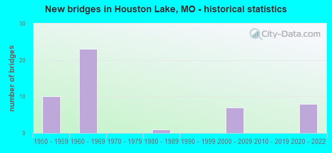
- New bridges - historical statistics
- 101950-1959
- 231960-1969
- 11980-1989
- 72000-2009
- 82020-2022

- Reconstructed bridges - Historical Statistics
- 11960-1969
- 01970-1979
- 91980-1989
- 01990-1999
- 32000-2009


- Bridge Condition - Deck
- 18.2%Excellent
- 9.1%Very good
- 18.2%Good
- 18.2%Satisfactory
- 22.7%Fair
- 4.5%Poor
- 9.1%Serious

- Bridge Condition - Superstructure
- 27.3%Excellent
- 4.5%Very good
- 9.1%Good
- 31.8%Satisfactory
- 18.2%Fair
- 9.1%Serious

- Bridge Condition - Substructure
- 22.7%Excellent
- 9.1%Very good
- 31.8%Good
- 31.8%Satisfactory
- 4.5%Poor

- Bridge Condition - Channel
- 50.0%Very good
- 25.0%Good
- 25.0%Satisfactory
Find on map >> Show street view
Structure Number: 1289, Location: S 18 T 51 N R 33 W (Lat: 39.225114, Lng: -94.650675), Route carried "on" structure: Interstate 29, Year Built: 1967, Year Reconstructed: 1985, Status: Posted for load, Structure Length: 6.37m (20.90ft), Average Daily Traffic: 38,109 (year 2021), Truck Traffic: 6%, Average Future Daily Traffic: 78,123 (year 2041), Design Load: HS 20, Features Intersected: CST NW 72ND ST
Minimum Vertical Clearance: 30+ m (98+ ft), Kilometerpoint: 188.759, Lanes on structure: 3, Lanes under structure: 5, Base Highway Network: Yes, Owner: State Highway Agency, Approaching Roadway Width: 14.6m (47.9ft), Skew: 21 degrees, Material/Design: Concrete continuous, Design/Construction: Slab, Number Of Spans In Main Unit: 4, Length of Maximum Span: 17.7m (58.1ft), Curb or Sidewalk Widths: Left: 0.2m (0.7ft), Right: 0.2m (0.7ft), Curb-To-Curb Width: 14.9m (48.9ft), Out-to-Out Width: 15.8m (51.8ft)
Condition: Deck: Fair, Superstructure: Fair, Substructure: Satisfactory, Operating Rating: 57.6 metric tons, Method Used To Determine Operating Rating: Load Factor (LF), Inventory Rating: 35.1 metric tons, Method Used To Determine Inventory Rating: Load Factor (LF), Structural Evaluation: Somewhat better than minimum adequacy, Deck Geometry: Meets minimum limits, Underclear: Meets minimum limits, Approach Roadway Alignment: Equal to present desirable criteria, Designated Inspection Frequency: Every 24 months, Inspection Date: October 2020, Deck Structure Type: Concrete Cast-file-Place, Wearing Surface/Protective System: Wearing Surface: Bituminous, Membrane: Built-up
Find on map >> Show street view
Structure Number: 129, Location: S 7 T 48 N R 14 W (Lat: 38.966906, Lng: -92.533672), Route carried "on" structure: State highway BB, Year Built: 1958, Status: Open, Structure Length: 7.13m (23.39ft), Average Daily Traffic: 762 (year 2021), Truck Traffic: 10%, Average Future Daily Traffic: 1,334 (year 2041), Design Load: H 15, Features Intersected: IS 70
Minimum Vertical Clearance: 30+ m (98+ ft), Kilometerpoint: 3.645, Lanes on structure: 2, Lanes under structure: 4, Owner: State Highway Agency, Approaching Roadway Width: 7.3m (24.0ft), Skew: 2 degrees, Material/Design: Concrete continuous, Design/Construction: Slab, Number Of Spans In Main Unit: 4, Length of Maximum Span: 19.2m (63.0ft), Curb-To-Curb Width: 7.3m (24.0ft), Out-to-Out Width: 8.1m (26.6ft)
Condition: Deck: Serious, Superstructure: Serious, Substructure: Good, Operating Rating: 36.0 metric tons, Method Used To Determine Operating Rating: Load Factor (LF), Inventory Rating: 21.6 metric tons, Method Used To Determine Inventory Rating: Load Factor (LF), Structural Evaluation: High priority of corrective action, Deck Geometry: Meets minimum limits, Underclear: Meets minimum limits, Approach Roadway Alignment: Equal to present desirable criteria, Length Of Structure Improvement: 0.82m (2.69ft), Designated Inspection Frequency: Every 24 months, Inspection Date: September 2021, Bridge Improvement Cost: $936,000, Roadway Improvement Cost: $94,000, Total Project Cost: $1,404,000 ( Estimate for 2022), Deck Structure Type: Concrete Cast-file-Place, Wearing Surface/Protective System: Wearing Surface: Other
Find on map >> Show street view
Structure Number: 129, Location: S 18 T 51 N R 33 W (Lat: 39.225108, Lng: -94.650481), Route carried "on" structure: Interstate 29, Year Built: 1967, Year Reconstructed: 1985, Status: Posted for load, Structure Length: 6.37m (20.90ft), Average Daily Traffic: 56,646 (year 2021), Truck Traffic: 6%, Average Future Daily Traffic: 116,124 (year 2041), Design Load: HS 20, Features Intersected: CST NW 72ND ST
Minimum Vertical Clearance: 30+ m (98+ ft), Kilometerpoint: 18.355, Lanes on structure: 3, Lanes under structure: 5, Base Highway Network: Yes, Owner: State Highway Agency, Approaching Roadway Width: 14.6m (47.9ft), Skew: 21 degrees, Material/Design: Concrete continuous, Design/Construction: Slab, Number Of Spans In Main Unit: 4, Length of Maximum Span: 17.7m (58.1ft), Curb or Sidewalk Widths: Left: 0.2m (0.7ft), Right: 0.2m (0.7ft), Curb-To-Curb Width: 14.9m (48.9ft), Out-to-Out Width: 15.8m (51.8ft)
Condition: Deck: Fair, Superstructure: Fair, Substructure: Satisfactory, Operating Rating: 57.6 metric tons, Method Used To Determine Operating Rating: Load Factor (LF), Inventory Rating: 35.1 metric tons, Method Used To Determine Inventory Rating: Load Factor (LF), Structural Evaluation: Somewhat better than minimum adequacy, Deck Geometry: Meets minimum limits, Underclear: Meets minimum limits, Approach Roadway Alignment: Equal to present desirable criteria, Designated Inspection Frequency: Every 24 months, Inspection Date: October 2020, Deck Structure Type: Concrete Cast-file-Place, Wearing Surface/Protective System: Wearing Surface: Bituminous, Membrane: Built-up
Find on map >> Show street view
Structure Number: 1383, Location: S 33 T 51 N R 33 W (Lat: 39.190922, Lng: -94.615050), Route carried "on" structure: Ramp State highway , Year Built: 1967, Year Reconstructed: 1991, Status: Open, Structure Length: 9.08m (29.79ft), Average Daily Traffic: 12,735 (year 2021), Truck Traffic: 11%, Average Future Daily Traffic: 26,107 (year 2041), Design Load: HS 20, Features Intersected: IS 29, RP IS29S TO NW GA, Facility Carried by Structure: RP IS29N TO IS635S
Minimum Vertical Clearance: 30+ m (98+ ft), Kilometerpoint: 0.143, Lanes on structure: 2, Lanes under structure: 3, Base Highway Network: Yes, Owner: State Highway Agency, Approaching Roadway Width: 11.6m (38.1ft), Material/Design: Concrete continuous, Design/Construction: Box Beam or Girders - Single/Spread, Number Of Spans In Main Unit: 4, Length of Maximum Span: 27.7m (90.9ft), Curb-To-Curb Width: 9.8m (32.2ft), Out-to-Out Width: 10.6m (34.8ft)
Condition: Deck: Satisfactory, Superstructure: Satisfactory, Substructure: Very good, Operating Rating: 70.2 metric tons, Method Used To Determine Operating Rating: Load Factor (LF), Inventory Rating: 42.3 metric tons, Method Used To Determine Inventory Rating: Load Factor (LF), Structural Evaluation: Equal to present minimum criteria, Deck Geometry: Equal to present minimum criteria, Underclear: Meets minimum limits, Approach Roadway Alignment: Equal to present desirable criteria, Designated Inspection Frequency: Every 24 months, Inspection Date: October 2020, Deck Structure Type: Concrete Cast-file-Place, Wearing Surface/Protective System: Wearing Surface: Bituminous
Find on map >> Show street view
Structure Number: 1384, Location: S 33 T 51 N R 33 W (Lat: 39.191142, Lng: -94.615656), Route carried "on" structure: Interstate 635, Year Built: 1967, Year Reconstructed: 1985, Status: Open, Structure Length: 12.01m (39.40ft), Average Daily Traffic: 26,631 (year 2021), Truck Traffic: 14%, Average Future Daily Traffic: 54,594 (year 2041), Design Load: HS 20, Features Intersected: IS 29, RP IS29N TO IS635
Minimum Vertical Clearance: 30+ m (98+ ft), Kilometerpoint: 5.832, Lanes on structure: 1, Lanes under structure: 5, Base Highway Network: Yes, Owner: State Highway Agency, Approaching Roadway Width: 9.8m (32.2ft), Material/Design: Concrete continuous, Design/Construction: Box Beam or Girders - Single/Spread, Number Of Spans In Main Unit: 5, Length of Maximum Span: 27.7m (90.9ft), Curb-To-Curb Width: 9.8m (32.2ft), Out-to-Out Width: 10.6m (34.8ft)
Condition: Deck: Fair, Superstructure: Fair, Substructure: Satisfactory, Operating Rating: 78.3 metric tons, Method Used To Determine Operating Rating: Load Factor (LF), Inventory Rating: 46.8 metric tons, Method Used To Determine Inventory Rating: Load Factor (LF), Structural Evaluation: Somewhat better than minimum adequacy, Deck Geometry: Meets minimum limits, Underclear: Meets minimum limits, Approach Roadway Alignment: Equal to present desirable criteria, Designated Inspection Frequency: Every 24 months, Inspection Date: October 2020, Deck Structure Type: Concrete Cast-file-Place, Wearing Surface/Protective System: Wearing Surface: Low Slump Concrete
Find on map >> Show street view
Structure Number: 1385, Location: S 33 T 51 N R 33 W (Lat: 39.190042, Lng: -94.614161), Route carried "on" structure: Ramp State highway , Year Built: 1967, Year Reconstructed: 1985, Status: Open, Structure Length: 5.46m (17.91ft), Average Daily Traffic: 3,699 (year 2021), Truck Traffic: 5%, Average Future Daily Traffic: 7,583 (year 2041), Design Load: H 20, Features Intersected: RP IS635N TO IS29S, Facility Carried by Structure: RP IS29S TO NW GAT
Minimum Vertical Clearance: 30+ m (98+ ft), Kilometerpoint: 0.143, Lanes on structure: 1, Lanes under structure: 2, Base Highway Network: Yes, Owner: State Highway Agency, Approaching Roadway Width: 7.9m (25.9ft), Skew: 1 degrees, Material/Design: Concrete continuous, Design/Construction: Slab, Number Of Spans In Main Unit: 3, Length of Maximum Span: 21.3m (69.9ft), Curb-To-Curb Width: 7.3m (24.0ft), Out-to-Out Width: 8.1m (26.6ft)
Condition: Deck: Satisfactory, Superstructure: Satisfactory, Substructure: Good, Operating Rating: 62.1 metric tons, Method Used To Determine Operating Rating: Load Factor (LF), Inventory Rating: 36.9 metric tons, Method Used To Determine Inventory Rating: Load Factor (LF), Structural Evaluation: Equal to present minimum criteria, Deck Geometry: Better than present minimum criteria, Underclear: Equal to present minimum criteria, Approach Roadway Alignment: Equal to present minimum criteria, Designated Inspection Frequency: Every 24 months, Inspection Date: October 2020, Deck Structure Type: Concrete Cast-file-Place, Wearing Surface/Protective System: Wearing Surface: Low Slump Concrete
Find on map >> Show street view
Structure Number: 1441, Location: S 7 T 51 N R 33 W (Lat: 39.246939, Lng: -94.658531), Route carried "on" structure: Interstate 29, Year Built: 1968, Year Reconstructed: 1985, Status: Posted for load, Structure Length: 5.46m (17.91ft), Average Daily Traffic: 33,238 (year 2021), Truck Traffic: 6%, Average Future Daily Traffic: 68,138 (year 2041), Design Load: H 20, Features Intersected: CST NW BARRY RD
Minimum Vertical Clearance: 30+ m (98+ ft), Kilometerpoint: 186.182, Lanes on structure: 3, Lanes under structure: 10, Base Highway Network: Yes, Owner: State Highway Agency, Approaching Roadway Width: 14.6m (47.9ft), Skew: 20 degrees, Material/Design: Concrete continuous, Design/Construction: Slab, Number Of Spans In Main Unit: 4, Length of Maximum Span: 16.5m (54.1ft), Curb or Sidewalk Widths: Left: 0.2m (0.7ft), Right: 0.2m (0.7ft), Curb-To-Curb Width: 14.9m (48.9ft), Out-to-Out Width: 15.8m (51.8ft)
Condition: Deck: Satisfactory, Superstructure: Satisfactory, Substructure: Good, Operating Rating: 51.3 metric tons, Method Used To Determine Operating Rating: Load Factor (LF), Inventory Rating: 30.6 metric tons, Method Used To Determine Inventory Rating: Load Factor (LF), Structural Evaluation: Equal to present minimum criteria, Deck Geometry: Meets minimum limits, Approach Roadway Alignment: Equal to present desirable criteria, Designated Inspection Frequency: Every 24 months, Inspection Date: October 2020, Deck Structure Type: Concrete Cast-file-Place, Wearing Surface/Protective System: Wearing Surface: Low Slump Concrete, Membrane: Built-up
Find on map >> Show street view
Structure Number: 1442, Location: S 7 T 51 N R 33 W (Lat: 39.246975, Lng: -94.658278), Route carried "on" structure: Interstate 29, Year Built: 1968, Year Reconstructed: 1985, Status: Posted for load, Structure Length: 5.46m (17.91ft), Average Daily Traffic: 35,138 (year 2021), Truck Traffic: 6%, Average Future Daily Traffic: 72,033 (year 2041), Design Load: H 20, Features Intersected: CST NW BARRY RD
Minimum Vertical Clearance: 30+ m (98+ ft), Kilometerpoint: 20.954, Lanes on structure: 3, Lanes under structure: 10, Base Highway Network: Yes, Owner: State Highway Agency, Approaching Roadway Width: 14.6m (47.9ft), Skew: 20 degrees, Material/Design: Concrete continuous, Design/Construction: Slab, Number Of Spans In Main Unit: 4, Length of Maximum Span: 16.5m (54.1ft), Curb or Sidewalk Widths: Left: 0.2m (0.7ft), Right: 0.2m (0.7ft), Curb-To-Curb Width: 14.9m (48.9ft), Out-to-Out Width: 15.8m (51.8ft)
Condition: Deck: Satisfactory, Superstructure: Satisfactory, Substructure: Good, Operating Rating: 51.3 metric tons, Method Used To Determine Operating Rating: Load Factor (LF), Inventory Rating: 30.6 metric tons, Method Used To Determine Inventory Rating: Load Factor (LF), Structural Evaluation: Equal to present minimum criteria, Deck Geometry: Meets minimum limits, Approach Roadway Alignment: Equal to present desirable criteria, Designated Inspection Frequency: Every 24 months, Inspection Date: October 2020, Deck Structure Type: Concrete Cast-file-Place, Wearing Surface/Protective System: Wearing Surface: Low Slump Concrete
Find on map >> Show street view
Structure Number: 18929, Location: S 24 T 51 N R 33 W (Lat: 39.190711, Lng: -94.617633), Route carried "on" structure: City street , Year Built: 1960, Year Reconstructed: 1994, Status: Closed, Structure Length: 3.17m (10.40ft), Average Daily Traffic: 120 (year 2020), Truck Traffic: 10%, Average Future Daily Traffic: 228 (year 2040), Features Intersected: DAM SPLWY, Facility Carried by Structure: HOUSTON LAKE DR
Minimum Vertical Clearance: 30+ m (98+ ft), Kilometerpoint: 0.161, Lanes on structure: 1, Owner: City or Municipal Highway Agency, Approaching Roadway Width: 3.4m (11.2ft), Material/Design: Steel continuous, Design/Construction: Stringer/Multi-beam, Number Of Spans In Main Unit: 6, Length of Maximum Span: 5.2m (17.1ft), Curb-To-Curb Width: 3.3m (10.8ft), Out-to-Out Width: 5.1m (16.7ft)
Condition: Deck: Fair, Superstructure: Very good, Substructure: Good, Channel: Very good, Waterway Adequacy: Superior to present desirable criteria, Approach Roadway Alignment: Equal to present minimum criteria, Bridge Posting: Required (Relationship of Operating Rating to Maximum Legal Load: > 39.9% below), Length Of Structure Improvement: 0.40m (1.31ft), Designated Inspection Frequency: Every 24 months, Inspection Date: April 2018, Bridge Improvement Cost: $291,000, Roadway Improvement Cost: $29,000, Total Project Cost: $436,000 ( Estimate for 2022), Deck Structure Type: Wood or Timber, Wearing Surface/Protective System: Wearing Surface: Wood or Timber
Find on map >> Show street view
Structure Number: 31342, Location: S 7 T 50 N R 33 W (Lat: 39.160503, Lng: -94.641081), Route carried "on" structure: Interstate 635, Year Built: 2006, Status: Open, Structure Length: 7.36m (24.15ft), Average Daily Traffic: 24,927 (year 2021), Truck Traffic: 18%, Average Future Daily Traffic: 51,100 (year 2041), Design Load: HS 25 or greater, Features Intersected: CST HORIZONS PKWY
Minimum Vertical Clearance: 30+ m (98+ ft), Kilometerpoint: 4.703, Lanes on structure: 2, Lanes under structure: 8, Base Highway Network: Yes, Owner: State Highway Agency, Approaching Roadway Width: 12.2m (40.0ft), Material/Design: Steel continuous, Design/Construction: Stringer/Multi-beam, Number Of Spans In Main Unit: 4, Length of Maximum Span: 19.7m (64.6ft), Curb-To-Curb Width: 12.2m (40.0ft), Out-to-Out Width: 13.0m (42.7ft)
Condition: Deck: Good, Superstructure: Excellent, Substructure: Very good, Inventory Rating: 63.9 metric tons, Method Used To Determine Inventory Rating: Load Factor (LF), Structural Evaluation: Equal to present desirable criteria, Deck Geometry: Better than present minimum criteria, Approach Roadway Alignment: Equal to present desirable criteria, Designated Inspection Frequency: Every 24 months, Inspection Date: October 2020, Deck Structure Type: Concrete Cast-file-Place, Wearing Surface/Protective System: Wearing Surface: Monolithic Concrete, Deck Protection: Epoxy Coated Reinforcing
Find on map >> Show street view
Structure Number: 31343, Location: S 7 T 50 N R 33 W (Lat: 39.160231, Lng: -94.641078), Route carried "on" structure: Interstate 635, Year Built: 2006, Status: Open, Structure Length: 7.36m (24.15ft), Average Daily Traffic: 23,182 (year 2021), Truck Traffic: 13%, Average Future Daily Traffic: 47,523 (year 2041), Design Load: HS 25 or greater, Features Intersected: CST HORIZONS PKWY
Minimum Vertical Clearance: 30+ m (98+ ft), Kilometerpoint: 1.139, Lanes on structure: 2, Lanes under structure: 8, Base Highway Network: Yes, Owner: State Highway Agency, Approaching Roadway Width: 12.2m (40.0ft), Material/Design: Steel continuous, Design/Construction: Stringer/Multi-beam, Number Of Spans In Main Unit: 4, Length of Maximum Span: 19.7m (64.6ft), Curb-To-Curb Width: 12.2m (40.0ft), Out-to-Out Width: 13.0m (42.7ft)
Condition: Deck: Good, Superstructure: Excellent, Substructure: Excellent, Inventory Rating: 63.9 metric tons, Method Used To Determine Inventory Rating: Load Factor (LF), Structural Evaluation: Superior to present desirable criteria, Deck Geometry: Better than present minimum criteria, Approach Roadway Alignment: Equal to present desirable criteria, Designated Inspection Frequency: Every 24 months, Inspection Date: October 2020, Deck Structure Type: Concrete Cast-file-Place, Wearing Surface/Protective System: Wearing Surface: Monolithic Concrete, Deck Protection: Epoxy Coated Reinforcing
Find on map >> Show street view
Structure Number: 31344, Location: S 8 T 50 N R 33 W (Lat: 39.161467, Lng: -94.641094), Route carried "on" structure: City street , Year Built: 2006, Status: Open, Structure Length: 0.78m (2.56ft), Average Daily Traffic: 2,226 (year 2021), Truck Traffic: 5%, Average Future Daily Traffic: 4,007 (year 2041), Design Load: HS 20, Features Intersected: DRAIN DTCH, Facility Carried by Structure: HORIZONS PKWY S
Minimum Vertical Clearance: 30+ m (98+ ft), Kilometerpoint: 1.587, Lanes on structure: 8, Owner: State Highway Agency, Approaching Roadway Width: 49.8m (163.4ft), Material/Design: Concrete continuous, Design/Construction: Culvert, Number Of Spans In Main Unit: 3, Length of Maximum Span: 2.4m (7.9ft)
Condition: Channel: Very good, Culverts: Excellent, Operating Rating: 87.3 metric tons, Method Used To Determine Operating Rating: Field evaluation and documented engineering judgment, Inventory Rating: 52.2 metric tons, Method Used To Determine Inventory Rating: Field evaluation and documented engineering judgment, Structural Evaluation: Superior to present desirable criteria, Waterway Adequacy: Superior to present desirable criteria, Approach Roadway Alignment: Equal to present desirable criteria, Designated Inspection Frequency: Every 24 months, Inspection Date: December 2020
Find on map >> Show street view
Structure Number: 36508, Location: S 28 T 51 N R 33 W (Lat: 39.196281, Lng: -94.620800), Route carried "on" structure: Interstate 29, Year Built: 2021, Status: Open, Structure Length: 2.18m (7.15ft), Average Daily Traffic: 59,257 (year 2021), Truck Traffic: 6%, Average Future Daily Traffic: 121,477 (year 2041), Features Intersected: CST NW 56TH ST
Minimum Vertical Clearance: 30+ m (98+ ft), Kilometerpoint: 192.933, Lanes on structure: 3, Lanes under structure: 3, Base Highway Network: Yes, Owner: State Highway Agency, Approaching Roadway Width: 16.2m (53.1ft), Material/Design: Prestressed concrete, Design/Construction: Tee Beam, Number Of Spans In Main Unit: 1, Length of Maximum Span: 20.7m (67.9ft), Curb-To-Curb Width: 16.2m (53.1ft), Out-to-Out Width: 17.0m (55.8ft)
Condition: Deck: Excellent, Superstructure: Excellent, Substructure: Excellent, Operating Rating: 97.2 metric tons, Method Used To Determine Operating Rating: Load Factor (LF), Inventory Rating: 48.6 metric tons, Method Used To Determine Inventory Rating: Load Factor (LF), Structural Evaluation: Superior to present desirable criteria, Deck Geometry: Equal to present minimum criteria, Underclear: Meets minimum limits, Approach Roadway Alignment: Equal to present desirable criteria, Designated Inspection Frequency: Every 24 months, Inspection Date: January 2022, Deck Structure Type: Concrete Cast-file-Place, Wearing Surface/Protective System: Wearing Surface: Monolithic Concrete, Deck Protection: Epoxy Coated Reinforcing
Find on map >> Show street view
Structure Number: 36509, Location: S 28 T 1 N R 33 W (Lat: 39.196411, Lng: -94.620639), Route carried "on" structure: Interstate 29, Year Built: 2021, Status: Open, Structure Length: 2.18m (7.15ft), Average Daily Traffic: 122,392 (year 2021), Truck Traffic: 6%, Average Future Daily Traffic: 250,904 (year 2041), Features Intersected: CST NW 56TH ST
Minimum Vertical Clearance: 30+ m (98+ ft), Kilometerpoint: 14.236, Lanes on structure: 4, Lanes under structure: 3, Base Highway Network: Yes, Owner: State Highway Agency, Approaching Roadway Width: 18.6m (61.0ft), Material/Design: Prestressed concrete, Design/Construction: Tee Beam, Number Of Spans In Main Unit: 1, Length of Maximum Span: 20.7m (67.9ft), Curb-To-Curb Width: 18.6m (61.0ft), Out-to-Out Width: 19.1m (62.7ft)
Condition: Deck: Excellent, Superstructure: Excellent, Substructure: Excellent, Inventory Rating: 50.4 metric tons, Method Used To Determine Inventory Rating: Load Factor (LF), Structural Evaluation: Superior to present desirable criteria, Deck Geometry: Meets minimum limits, Underclear: Meets minimum limits, Approach Roadway Alignment: Equal to present desirable criteria, Designated Inspection Frequency: Every 24 months, Inspection Date: January 2022, Deck Structure Type: Concrete Cast-file-Place, Wearing Surface/Protective System: Wearing Surface: Monolithic Concrete, Deck Protection: Epoxy Coated Reinforcing
Find on map >> Show street view
Structure Number: 3651, Location: S 10 T 57 N R 33 W (Lat: 39.768978, Lng: -94.595922), Route carried "on" structure: State highway 6, Year Built: 1987, Status: Open, Structure Length: 2.96m (9.71ft), Average Daily Traffic: 681 (year 2021), Truck Traffic: 15%, Average Future Daily Traffic: 885 (year 2041), Design Load: HS 20, Features Intersected: JORDAN CR
Minimum Vertical Clearance: 30+ m (98+ ft), Kilometerpoint: 18.532, Lanes on structure: 2, Owner: State Highway Agency, Approaching Roadway Width: 6.7m (22.0ft), Skew: 2 degrees, Material/Design: Prestressed concrete continuous, Design/Construction: Tee Beam, Number Of Spans In Main Unit: 3, Length of Maximum Span: 10.0m (32.8ft), Curb or Sidewalk Widths: Left: 0.2m (0.7ft), Right: 0.2m (0.7ft), Curb-To-Curb Width: 10.0m (32.8ft), Out-to-Out Width: 10.8m (35.4ft)
Condition: Deck: Good, Superstructure: Good, Substructure: Good, Channel: Satisfactory, Operating Rating: 57.6 metric tons, Method Used To Determine Operating Rating: Allowable Stress (AS), Inventory Rating: 44.1 metric tons, Method Used To Determine Inventory Rating: Allowable Stress (AS), Structural Evaluation: Better than present minimum criteria, Deck Geometry: Equal to present minimum criteria, Waterway Adequacy: Equal to present desirable criteria, Approach Roadway Alignment: Equal to present desirable criteria, Designated Inspection Frequency: Every 24 months, Inspection Date: December 2021, Deck Structure Type: Concrete Cast-file-Place, Wearing Surface/Protective System: Wearing Surface: Monolithic Concrete
Find on map >> Show street view
Structure Number: 3651, Location: S 33 T 51 N R 33 W (Lat: 39.188919, Lng: -94.606481), Route carried "on" structure: Interstate 29, Year Built: 2021, Status: Not yet open, Structure Length: 2.52m (8.27ft), Average Daily Traffic: 47,666 (year 2021), Truck Traffic: 6%, Average Future Daily Traffic: 97,715 (year 2041), Features Intersected: RT AA
Minimum Vertical Clearance: 30+ m (98+ ft), Kilometerpoint: 194.494, Lanes on structure: 4, Lanes under structure: 3, Base Highway Network: Yes, Owner: State Highway Agency, Approaching Roadway Width: 20.7m (67.9ft), Skew: 1 degrees, Material/Design: Prestressed concrete, Design/Construction: Box Beam or Girders - Single/Spread, Number Of Spans In Main Unit: 1, Length of Maximum Span: 24.1m (79.1ft), Curb-To-Curb Width: 20.7m (67.9ft), Out-to-Out Width: 21.5m (70.5ft)
Condition: Deck: Excellent, Superstructure: Excellent, Substructure: Excellent, Operating Rating: 75.6 metric tons, Method Used To Determine Operating Rating: Load Factor (LF), Inventory Rating: 24.3 metric tons, Method Used To Determine Inventory Rating: Load Factor (LF), Structural Evaluation: Equal to present minimum criteria, Deck Geometry: Equal to present minimum criteria, Underclear: Equal to present minimum criteria, Approach Roadway Alignment: Equal to present desirable criteria, Designated Inspection Frequency: Every 24 months, Inspection Date: January 2021, Deck Structure Type: Concrete Cast-file-Place, Wearing Surface/Protective System: Wearing Surface: Monolithic Concrete, Deck Protection: Epoxy Coated Reinforcing
Find on map >> Show street view
Structure Number: 36511, Location: S 33 T 51 N R 33 W (Lat: 39.189119, Lng: -94.606519), Route carried "on" structure: Interstate 29, Year Built: 2021, Status: Not yet open, Structure Length: 2.52m (8.27ft), Average Daily Traffic: 56,182 (year 2021), Truck Traffic: 6%, Average Future Daily Traffic: 115,173 (year 2041), Features Intersected: RT AA
Minimum Vertical Clearance: 30+ m (98+ ft), Kilometerpoint: 12.715, Lanes on structure: 4, Lanes under structure: 3, Base Highway Network: Yes, Owner: State Highway Agency, Approaching Roadway Width: 20.7m (67.9ft), Skew: 1 degrees, Material/Design: Prestressed concrete, Design/Construction: Box Beam or Girders - Single/Spread, Number Of Spans In Main Unit: 1, Length of Maximum Span: 24.1m (79.1ft), Curb-To-Curb Width: 20.7m (67.9ft), Out-to-Out Width: 21.5m (70.5ft)
Condition: Deck: Excellent, Superstructure: Excellent, Substructure: Excellent, Operating Rating: 75.6 metric tons, Method Used To Determine Operating Rating: Load Factor (LF), Inventory Rating: 24.3 metric tons, Method Used To Determine Inventory Rating: Load Factor (LF), Structural Evaluation: Equal to present minimum criteria, Deck Geometry: Equal to present minimum criteria, Underclear: Equal to present minimum criteria, Approach Roadway Alignment: Equal to present desirable criteria, Designated Inspection Frequency: Every 24 months, Inspection Date: January 2021, Deck Structure Type: Concrete Cast-file-Place, Wearing Surface/Protective System: Wearing Surface: Monolithic Concrete, Deck Protection: Epoxy Coated Reinforcing
Find on map >> Show street view
Structure Number: 6432, Location: S 33 T 51 N R 33 W (Lat: 39.189472, Lng: -94.609608), Route carried "on" structure: Interstate 29, Year Built: 1957, Year Reconstructed: 2007, Status: Posted for load, Structure Length: 5.97m (19.59ft), Average Daily Traffic: 103,848 (year 2021), Truck Traffic: 6%, Average Future Daily Traffic: 212,888 (year 2041), Design Load: HS 20, Features Intersected: LINE CR
Minimum Vertical Clearance: 30+ m (98+ ft), Kilometerpoint: 194.200, Lanes on structure: 8, Base Highway Network: Yes, Owner: State Highway Agency, Approaching Roadway Width: 41.5m (136.2ft), Skew: 21 degrees, Material/Design: Steel continuous, Design/Construction: Stringer/Multi-beam, Number Of Spans In Main Unit: 3, Length of Maximum Span: 21.9m (71.9ft), Curb-To-Curb Width: 42.1m (138.1ft), Out-to-Out Width: 42.9m (140.7ft)
Condition: Deck: Good, Superstructure: Good, Substructure: Satisfactory, Channel: Good, Operating Rating: 58.5 metric tons, Method Used To Determine Operating Rating: Load Factor (LF), Inventory Rating: 35.1 metric tons, Method Used To Determine Inventory Rating: Load Factor (LF), Structural Evaluation: Equal to present minimum criteria, Deck Geometry: Superior to present desirable criteria, Waterway Adequacy: Equal to present desirable criteria, Approach Roadway Alignment: Equal to present desirable criteria, Designated Inspection Frequency: Every 24 months, Inspection Date: October 2020, Deck Structure Type: Concrete Cast-file-Place, Wearing Surface/Protective System: Wearing Surface: Monolithic Concrete, Deck Protection: Epoxy Coated Reinforcing
Find on map >> Show street view
Structure Number: 6433, Location: S 33 T 51 N R 33 W (Lat: 39.188908, Lng: -94.606464), Route carried "on" structure: Interstate 29, Year Built: 1957, Year Reconstructed: 1974, Status: Posted for load, Structure Length: 3.75m (12.30ft), Average Daily Traffic: 103,848 (year 2021), Truck Traffic: 6%, Average Future Daily Traffic: 212,888 (year 2041), Design Load: HS 20, Features Intersected: RT AA
Minimum Vertical Clearance: 30+ m (98+ ft), Kilometerpoint: 194.491, Lanes on structure: 8, Lanes under structure: 2, Base Highway Network: Yes, Owner: State Highway Agency, Approaching Roadway Width: 41.5m (136.2ft), Skew: 21 degrees, Material/Design: Concrete, Design/Construction: Stringer/Multi-beam, Number Of Spans In Main Unit: 3, Length of Maximum Span: 14.5m (47.6ft), Curb-To-Curb Width: 42.1m (138.1ft), Out-to-Out Width: 42.9m (140.7ft)
Condition: Deck: Poor, Superstructure: Serious, Substructure: Poor, Operating Rating: 51.3 metric tons, Method Used To Determine Operating Rating: Load Factor (LF), Inventory Rating: 30.6 metric tons, Method Used To Determine Inventory Rating: Load Factor (LF), Structural Evaluation: High priority of corrective action, Deck Geometry: Superior to present desirable criteria, Underclear: High priority of replacement, Approach Roadway Alignment: Equal to present desirable criteria, Length Of Structure Improvement: 0.47m (1.54ft), Designated Inspection Frequency: Every 12 months, Inspection Date: October 2021, Bridge Improvement Cost: $1,793,000, Roadway Improvement Cost: $179,000, Total Project Cost: $2,689,000 ( Estimate for 2022), Deck Structure Type: Concrete Cast-file-Place, Wearing Surface/Protective System: Wearing Surface: Bituminous
Find on map >> Show street view
Structure Number: 6434, Location: S 23 T 51 N R 33 W (Lat: 39.190169, Lng: -94.613503), Route carried "on" structure: Ramp State highway , Year Built: 1957, Year Reconstructed: 1985, Status: Posted for load, Structure Length: 18.32m (60.10ft), Average Daily Traffic: 3,608 (year 2021), Truck Traffic: 5%, Average Future Daily Traffic: 7,396 (year 2041), Design Load: H 20, Features Intersected: IS 29, RP IS635N TO IS29, Facility Carried by Structure: RP NW GATEWAY AVE
Minimum Vertical Clearance: 30+ m (98+ ft), Kilometerpoint: 0.050, Lanes on structure: 1, Lanes under structure: 8, Base Highway Network: Yes, Owner: State Highway Agency, Approaching Roadway Width: 7.9m (25.9ft), Skew: 5 degrees, Material/Design: Steel continuous, Design/Construction: Stringer/Multi-beam, Number Of Spans In Main Unit: 7, Number Of Approach Spans: 3, Length of Maximum Span: 28.4m (93.2ft), Curb or Sidewalk Widths: Left: 0.2m (0.7ft), Right: 0.2m (0.7ft), Curb-To-Curb Width: 9.1m (29.9ft), Out-to-Out Width: 10.1m (33.1ft)
Condition: Deck: Fair, Superstructure: Fair, Substructure: Satisfactory, Operating Rating: 41.4 metric tons, Method Used To Determine Operating Rating: Load Factor (LF), Inventory Rating: 24.3 metric tons, Method Used To Determine Inventory Rating: Load Factor (LF), Structural Evaluation: Somewhat better than minimum adequacy, Deck Geometry: Superior to present desirable criteria, Underclear: High priority of corrective action, Approach Roadway Alignment: Equal to present minimum criteria, Length Of Structure Improvement: 1.90m (6.23ft), Designated Inspection Frequency: Every 24 months, Inspection Date: August 2021, Bridge Improvement Cost: $1,550,000, Roadway Improvement Cost: $155,000, Total Project Cost: $2,325,000 ( Estimate for 2022), Deck Structure Type: Concrete Cast-file-Place, Wearing Surface/Protective System: Wearing Surface: Bituminous
Find on map >> Show street view
Structure Number: 95, Location: S 28 T 66 N R 15 W (Lat: 40.492719, Lng: -92.578125), Route carried "on" structure: US 136, Year Built: 1958, Status: Open, Structure Length: 5.39m (17.68ft), Average Daily Traffic: 1,325 (year 2021), Truck Traffic: 25%, Average Future Daily Traffic: 1,723 (year 2041), Design Load: H 20, Features Intersected: ABANDONED RR
Minimum Vertical Clearance: 30+ m (98+ ft), Kilometerpoint: 304.807, Lanes on structure: 2, Base Highway Network: Yes, Owner: State Highway Agency, Approaching Roadway Width: 11.0m (36.1ft), Skew: 4 degrees, Material/Design: Steel continuous, Design/Construction: Stringer/Multi-beam, Number Of Spans In Main Unit: 3, Length of Maximum Span: 18.9m (62.0ft), Curb-To-Curb Width: 8.5m (27.9ft), Out-to-Out Width: 10.1m (33.1ft)
Condition: Deck: Serious, Superstructure: Satisfactory, Substructure: Satisfactory, Operating Rating: 40.5 metric tons, Method Used To Determine Operating Rating: Load Factor (LF), Inventory Rating: 24.3 metric tons, Method Used To Determine Inventory Rating: Load Factor (LF), Structural Evaluation: Equal to present minimum criteria, Deck Geometry: Somewhat better than minimum adequacy, Approach Roadway Alignment: Equal to present minimum criteria, Length Of Structure Improvement: 0.64m (2.10ft), Designated Inspection Frequency: Every 24 months, Inspection Date: November 2021, Bridge Improvement Cost: $497,000, Roadway Improvement Cost: $50,000, Total Project Cost: $745,000 ( Estimate for 2022), Deck Structure Type: Concrete Cast-file-Place, Wearing Surface/Protective System: Wearing Surface: Bituminous
Find on map >> Show street view
Structure Number: 95, Location: S 20 T 51 N R 33 W (Lat: 39.210558, Lng: -94.638819), Route carried "on" structure: Interstate 29, Year Built: 1967, Year Reconstructed: 2014, Status: Open, Structure Length: 5.55m (18.21ft), Average Daily Traffic: 44,596 (year 2021), Truck Traffic: 6%, Average Future Daily Traffic: 91,422 (year 2041), Design Load: HS 20, Features Intersected: MO 45
Minimum Vertical Clearance: 30+ m (98+ ft), Kilometerpoint: 190.682, Lanes on structure: 3, Lanes under structure: 5, Base Highway Network: Yes, Owner: State Highway Agency, Approaching Roadway Width: 14.6m (47.9ft), Skew: 23 degrees, Material/Design: Steel continuous, Design/Construction: Stringer/Multi-beam, Number Of Spans In Main Unit: 3, Length of Maximum Span: 23.5m (77.1ft), Curb-To-Curb Width: 14.9m (48.9ft), Out-to-Out Width: 15.8m (51.8ft)
Condition: Deck: Very good, Superstructure: Satisfactory, Substructure: Good, Operating Rating: 56.7 metric tons, Method Used To Determine Operating Rating: Load Factor (LF), Inventory Rating: 34.2 metric tons, Method Used To Determine Inventory Rating: Load Factor (LF), Structural Evaluation: Equal to present minimum criteria, Deck Geometry: Meets minimum limits, Underclear: Meets minimum limits, Approach Roadway Alignment: Equal to present desirable criteria, Designated Inspection Frequency: Every 24 months, Inspection Date: October 2020, Deck Structure Type: Concrete Cast-file-Place, Wearing Surface/Protective System: Wearing Surface: Monolithic Concrete, Membrane: Built-up
Find on map >> Show street view
Structure Number: 951, Location: S 20 T 51 N R 33 W (Lat: 39.210550, Lng: -94.638583), Route carried "on" structure: Interstate 29, Year Built: 1967, Year Reconstructed: 2014, Status: Posted for load, Structure Length: 5.55m (18.21ft), Average Daily Traffic: 63,135 (year 2021), Truck Traffic: 6%, Average Future Daily Traffic: 129,427 (year 2041), Design Load: HS 20, Features Intersected: MO 45
Minimum Vertical Clearance: 30+ m (98+ ft), Kilometerpoint: 16.439, Lanes on structure: 3, Lanes under structure: 5, Base Highway Network: Yes, Owner: State Highway Agency, Approaching Roadway Width: 14.6m (47.9ft), Skew: 23 degrees, Material/Design: Steel continuous, Design/Construction: Stringer/Multi-beam, Number Of Spans In Main Unit: 3, Length of Maximum Span: 23.5m (77.1ft), Curb-To-Curb Width: 14.9m (48.9ft), Out-to-Out Width: 15.8m (51.8ft)
Condition: Deck: Very good, Superstructure: Satisfactory, Substructure: Satisfactory, Operating Rating: 56.7 metric tons, Method Used To Determine Operating Rating: Load Factor (LF), Inventory Rating: 34.2 metric tons, Method Used To Determine Inventory Rating: Load Factor (LF), Structural Evaluation: Equal to present minimum criteria, Deck Geometry: Meets minimum limits, Underclear: Meets minimum limits, Approach Roadway Alignment: Equal to present desirable criteria, Designated Inspection Frequency: Every 24 months, Inspection Date: October 2020, Deck Structure Type: Concrete Cast-file-Place, Wearing Surface/Protective System: Wearing Surface: Monolithic Concrete
Find on map >> Show street view
Structure Number: 1289, Location: S 18 T 51 N R 33 W (Lat: 39.225114, Lng: -94.650675), Route carried "under" structure: City street , Year Built: 1967, Structure Length: 0. m, Average Daily Traffic: 8,332 (year 2021), Truck Traffic: 4%, Features Intersected: CST NW 72ND ST, Facility Carried by Structure: IS 29 S
Minimum Vertical Clearance: 4.57m (14.99ft), Kilometerpoint: 0.772, Lanes on structure: 3, Lanes under structure: 5, Material/Design: Concrete continuous, Design/Construction: Slab, Length of Maximum Span: 17.7m (58.1ft)
Find on map >> Show street view
Structure Number: 129, Location: S 18 T 51 N R 33 W (Lat: 39.225108, Lng: -94.650481), Route carried "under" structure: City street , Year Built: 1967, Structure Length: 0. m, Average Daily Traffic: 8,332 (year 2021), Truck Traffic: 4%, Features Intersected: CST NW 72ND ST, Facility Carried by Structure: IS 29 N
Minimum Vertical Clearance: 4.57m (14.99ft), Kilometerpoint: 0.789, Lanes on structure: 3, Lanes under structure: 5, Material/Design: Concrete continuous, Design/Construction: Slab, Length of Maximum Span: 17.7m (58.1ft)
Find on map >> Show street view
Structure Number: 1383, Location: S 33 T 51 N R 33 W (Lat: 39.190922, Lng: -94.615050), Route carried "under" structure: Ramp State highway , Year Built: 1967, Structure Length: 0. m, Average Daily Traffic: 3,699 (year 2021), Truck Traffic: 5%, Features Intersected: RP IS29S TO NW GATEWAY A, Facility Carried by Structure: RP IS29N TO IS635S
Minimum Vertical Clearance: 4.95m (16.24ft), Kilometerpoint: 0.034, Lanes on structure: 2, Lanes under structure: 1, Material/Design: Concrete continuous, Design/Construction: Box Beam or Girders - Single/Spread, Length of Maximum Span: 27.7m (90.9ft)
Find on map >> Show street view
Structure Number: 1383, Location: S 33 T 51 N R 33 W (Lat: 39.190922, Lng: -94.615050), Route carried "under" structure: Interstate 29, Year Built: 1967, Structure Length: 0. m, Average Daily Traffic: 47,666 (year 2021), Truck Traffic: 6%, Features Intersected: IS 29
Minimum Vertical Clearance: 5.26m (17.26ft), Kilometerpoint: 193.728, Lanes on structure: 2, Lanes under structure: 2, Material/Design: Concrete continuous, Design/Construction: Box Beam or Girders - Single/Spread, Length of Maximum Span: 27.7m (90.9ft)
Find on map >> Show street view
Structure Number: 1384, Location: S 33 T 51 N R 33 W (Lat: 39.191142, Lng: -94.615656), Route carried "under" structure: Interstate 29, Year Built: 1967, Structure Length: 0. m, Average Daily Traffic: 47,666 (year 2021), Truck Traffic: 6%, Features Intersected: IS 29, Facility Carried by Structure: IS 635 N
Minimum Vertical Clearance: 5.84m (19.16ft), Kilometerpoint: 193.669, Lanes on structure: 1, Lanes under structure: 3, Material/Design: Concrete continuous, Design/Construction: Box Beam or Girders - Single/Spread, Length of Maximum Span: 27.7m (90.9ft)
Find on map >> Show street view
Structure Number: 1384, Location: S 33 T 51 N R 33 W (Lat: 39.191142, Lng: -94.615656), Route carried "under" structure: Ramp State highway , Year Built: 1967, Structure Length: 0. m, Average Daily Traffic: 12,735 (year 2021), Truck Traffic: 11%, Features Intersected: RP IS29N TO IS635S, Facility Carried by Structure: IS 635 N
Minimum Vertical Clearance: 5.08m (16.67ft), Kilometerpoint: 0.245, Lanes on structure: 1, Lanes under structure: 2, Material/Design: Concrete continuous, Design/Construction: Box Beam or Girders - Single/Spread, Length of Maximum Span: 27.7m (90.9ft)
Find on map >> Show street view
Structure Number: 1385, Location: S 33 T 51 N R 33 W (Lat: 39.190042, Lng: -94.614161), Route carried "under" structure: Ramp State highway , Year Built: 1967, Structure Length: 0. m, Average Daily Traffic: 11,044 (year 2021), Truck Traffic: 10%, Features Intersected: RP IS635N TO IS29S, Facility Carried by Structure: RP IS29S TO NW GAT
Minimum Vertical Clearance: 5.08m (16.67ft), Kilometerpoint: 0.463, Lanes on structure: 1, Lanes under structure: 2, Material/Design: Concrete continuous, Design/Construction: Slab, Length of Maximum Span: 21.3m (69.9ft)
Find on map >> Show street view
Structure Number: 1441, Location: S 7 T 51 N R 33 W (Lat: 39.246939, Lng: -94.658531), Route carried "under" structure: City street , Year Built: 1968, Structure Length: 0. m, Average Daily Traffic: 7,389 (year 2021), Truck Traffic: 5%, Features Intersected: CST NW BARRY RD, Facility Carried by Structure: IS 29 S
Minimum Vertical Clearance: 4.72m (15.49ft), Kilometerpoint: 6.740, Lanes on structure: 3, Lanes under structure: 5, Material/Design: Concrete continuous, Design/Construction: Slab, Length of Maximum Span: 16.5m (54.1ft)
Find on map >> Show street view
Structure Number: 1441, Location: S 7 T 51 N R 33 W (Lat: 39.246939, Lng: -94.658531), Route carried "under" structure: City street , Year Built: 1968, Structure Length: 0. m, Average Daily Traffic: 11,119 (year 2021), Truck Traffic: 5%, Features Intersected: CST NW BARRY RD, Facility Carried by Structure: IS 29 S
Minimum Vertical Clearance: 4.78m (15.68ft), Kilometerpoint: 6.618, Lanes on structure: 3, Lanes under structure: 5, Material/Design: Concrete continuous, Design/Construction: Slab, Length of Maximum Span: 16.5m (54.1ft)
Find on map >> Show street view
Structure Number: 1442, Location: S 7 T 51 N R 33 W (Lat: 39.246975, Lng: -94.658278), Route carried "under" structure: City street , Year Built: 1968, Structure Length: 0. m, Average Daily Traffic: 11,119 (year 2021), Truck Traffic: 5%, Features Intersected: CST NW BARRY RD, Facility Carried by Structure: IS 29 N
Minimum Vertical Clearance: 4.70m (15.42ft), Kilometerpoint: 6.640, Lanes on structure: 3, Lanes under structure: 5, Material/Design: Concrete continuous, Design/Construction: Slab, Length of Maximum Span: 16.5m (54.1ft)
Find on map >> Show street view
Structure Number: 1442, Location: S 7 T 51 N R 33 W (Lat: 39.246975, Lng: -94.658278), Route carried "under" structure: City street , Year Built: 1968, Structure Length: 0. m, Average Daily Traffic: 7,389 (year 2021), Truck Traffic: 5%, Features Intersected: CST NW BARRY RD, Facility Carried by Structure: IS 29 N
Minimum Vertical Clearance: 4.72m (15.49ft), Kilometerpoint: 6.719, Lanes on structure: 3, Lanes under structure: 5, Material/Design: Concrete continuous, Design/Construction: Slab, Length of Maximum Span: 16.5m (54.1ft)
Find on map >> Show street view
Structure Number: 31342, Location: S 7 T 50 N R 33 W (Lat: 39.160503, Lng: -94.641081), Route carried "under" structure: City street , Year Built: 2006, Structure Length: 0. m, Average Daily Traffic: 1,113 (year 2021), Truck Traffic: 5%, Features Intersected: CST HORIZONS PKWY, Facility Carried by Structure: IS 635 S
Minimum Vertical Clearance: 4.77m (15.65ft), Kilometerpoint: 1.698, Lanes on structure: 2, Lanes under structure: 4, Material/Design: Steel continuous, Design/Construction: Stringer/Multi-beam, Length of Maximum Span: 19.7m (64.6ft)
Find on map >> Show street view
Structure Number: 31343, Location: S 7 T 50 N R 33 W (Lat: 39.160231, Lng: -94.641078), Route carried "under" structure: City street , Year Built: 2006, Structure Length: 0. m, Average Daily Traffic: 1,113 (year 2021), Truck Traffic: 5%, Features Intersected: CST HORIZONS PKWY, Facility Carried by Structure: IS 635 N
Minimum Vertical Clearance: 4.77m (15.65ft), Kilometerpoint: 1.728, Lanes on structure: 2, Lanes under structure: 4, Material/Design: Steel continuous, Design/Construction: Stringer/Multi-beam, Length of Maximum Span: 19.7m (64.6ft)
Find on map >> Show street view
Structure Number: 31343, Location: S 7 T 50 N R 33 W (Lat: 39.160231, Lng: -94.641078), Route carried "under" structure: City street , Year Built: 2006, Structure Length: 0. m, Average Daily Traffic: 1,113 (year 2021), Truck Traffic: 5%, Features Intersected: CST HORIZONS PKWY, Facility Carried by Structure: IS 635 N
Minimum Vertical Clearance: 4.77m (15.65ft), Kilometerpoint: 1.698, Lanes on structure: 2, Lanes under structure: 4, Material/Design: Steel continuous, Design/Construction: Stringer/Multi-beam, Length of Maximum Span: 19.7m (64.6ft)
Find on map >> Show street view
Structure Number: 36508, Location: S 28 T 51 N R 33 W (Lat: 39.196281, Lng: -94.620800), Route carried "under" structure: City street , Year Built: 2021, Structure Length: 0. m, Average Daily Traffic: 2,499 (year 2021), Truck Traffic: 3%, Features Intersected: CST NW 56TH ST, Facility Carried by Structure: IS 29 S
Minimum Vertical Clearance: 5.13m (16.83ft), Kilometerpoint: 2.504, Lanes on structure: 3, Lanes under structure: 3, Material/Design: Prestressed concrete, Design/Construction: Tee Beam, Length of Maximum Span: 20.7m (67.9ft)
Find on map >> Show street view
Structure Number: 36509, Location: S 28 T 1 N R 33 W (Lat: 39.196411, Lng: -94.620639), Route carried "under" structure: City street , Year Built: 2021, Structure Length: 0. m, Average Daily Traffic: 2,499 (year 2021), Truck Traffic: 3%, Features Intersected: CST NW 56TH ST, Facility Carried by Structure: IS 29 N
Minimum Vertical Clearance: 5.16m (16.93ft), Kilometerpoint: 2.523, Lanes on structure: 4, Lanes under structure: 3, Material/Design: Prestressed concrete, Design/Construction: Tee Beam, Length of Maximum Span: 20.7m (67.9ft)
Find on map >> Show street view
Structure Number: 3651, Location: S 33 T 51 N R 33 W (Lat: 39.188919, Lng: -94.606481), Route carried "under" structure: State highway AA, Year Built: 2021, Structure Length: 0. m, Average Daily Traffic: 4,734 (year 2021), Truck Traffic: 11%, Features Intersected: RT AA, Facility Carried by Structure: IS 29 S
Minimum Vertical Clearance: 5.18m (16.99ft), Kilometerpoint: 0.079, Lanes on structure: 4, Lanes under structure: 3, Material/Design: Prestressed concrete, Design/Construction: Box Beam or Girders - Single/Spread, Length of Maximum Span: 24.1m (79.1ft)
Find on map >> Show street view
Structure Number: 36511, Location: S 33 T 51 N R 33 W (Lat: 39.189119, Lng: -94.606519), Route carried "under" structure: State highway AA, Year Built: 2021, Structure Length: 0. m, Average Daily Traffic: 4,734 (year 2021), Truck Traffic: 11%, Features Intersected: RT AA, Facility Carried by Structure: IS 29 N
Minimum Vertical Clearance: 4.88m (16.01ft), Kilometerpoint: 0.056, Lanes on structure: 4, Lanes under structure: 3, Material/Design: Prestressed concrete, Design/Construction: Box Beam or Girders - Single/Spread, Length of Maximum Span: 24.1m (79.1ft)
Find on map >> Show street view
Structure Number: 6433, Location: S 33 T 51 N R 33 W (Lat: 39.188908, Lng: -94.606464), Route carried "under" structure: State highway AA, Year Built: 1957, Structure Length: 0. m, Average Daily Traffic: 4,734 (year 2021), Truck Traffic: 11%, Features Intersected: RT AA, Facility Carried by Structure: IS 29 S
Minimum Vertical Clearance: 4.75m (15.58ft), Kilometerpoint: 0.079, Lanes on structure: 8, Lanes under structure: 2, Material/Design: Concrete, Design/Construction: Stringer/Multi-beam, Length of Maximum Span: 14.5m (47.6ft)
Find on map >> Show street view
Structure Number: 6434, Location: S 23 T 51 N R 33 W (Lat: 39.190169, Lng: -94.613503), Route carried "under" structure: Interstate 29, Year Built: 1957, Structure Length: 0. m, Average Daily Traffic: 47,666 (year 2021), Truck Traffic: 6%, Features Intersected: IS 29, Facility Carried by Structure: RP NW GATEWAY AVE
Minimum Vertical Clearance: 5.54m (18.18ft), Kilometerpoint: 193.878, Lanes on structure: 1, Lanes under structure: 3, Material/Design: Steel continuous, Design/Construction: Stringer/Multi-beam, Length of Maximum Span: 28.4m (93.2ft)
Find on map >> Show street view
Structure Number: 6434, Location: S 23 T 51 N R 33 W (Lat: 39.190169, Lng: -94.613503), Route carried "under" structure: Interstate 29, Year Built: 1957, Structure Length: 0. m, Average Daily Traffic: 56,182 (year 2021), Truck Traffic: 6%, Features Intersected: IS 29, Facility Carried by Structure: RP NW GATEWAY AVE
Minimum Vertical Clearance: 5.54m (18.18ft), Kilometerpoint: 13.391, Lanes on structure: 1, Lanes under structure: 3, Material/Design: Steel continuous, Design/Construction: Stringer/Multi-beam, Length of Maximum Span: 28.4m (93.2ft)
Find on map >> Show street view
Structure Number: 6434, Location: S 23 T 51 N R 33 W (Lat: 39.190169, Lng: -94.613503), Route carried "under" structure: Ramp State highway , Year Built: 1957, Structure Length: 0. m, Average Daily Traffic: 11,044 (year 2021), Truck Traffic: 10%, Features Intersected: RP IS635N TO IS29S, Facility Carried by Structure: RP NW GATEWAY AVE
Minimum Vertical Clearance: 5.54m (18.18ft), Kilometerpoint: 0.518, Lanes on structure: 1, Lanes under structure: 1, Material/Design: Steel continuous, Design/Construction: Stringer/Multi-beam, Length of Maximum Span: 28.4m (93.2ft)
Find on map >> Show street view
Structure Number: 6434, Location: S 23 T 51 N R 33 W (Lat: 39.190169, Lng: -94.613503), Route carried "under" structure: Ramp State highway , Year Built: 1957, Structure Length: 0. m, Average Daily Traffic: 12,735 (year 2021), Truck Traffic: 11%, Features Intersected: RP IS29N TO IS635S, Facility Carried by Structure: RP NW GATEWAY AVE
Minimum Vertical Clearance: 5.54m (18.18ft), Kilometerpoint: 0.068, Lanes on structure: 1, Lanes under structure: 1, Material/Design: Steel continuous, Design/Construction: Stringer/Multi-beam, Length of Maximum Span: 28.4m (93.2ft)
Find on map >> Show street view
Structure Number: 95, Location: S 20 T 51 N R 33 W (Lat: 39.210558, Lng: -94.638819), Route carried "under" structure: State highway 45, Year Built: 1967, Structure Length: 0. m, Average Daily Traffic: 34,985 (year 2021), Truck Traffic: 12%, Features Intersected: MO 45, Facility Carried by Structure: IS 29 S
Minimum Vertical Clearance: 4.72m (15.49ft), Kilometerpoint: 59.369, Lanes on structure: 3, Lanes under structure: 5, Material/Design: Steel continuous, Design/Construction: Stringer/Multi-beam, Length of Maximum Span: 23.5m (77.1ft)
Find on map >> Show street view
Structure Number: 951, Location: S 20 T 51 N R 33 W (Lat: 39.210550, Lng: -94.638583), Route carried "under" structure: State highway 45, Year Built: 1967, Structure Length: 0. m, Average Daily Traffic: 34,985 (year 2021), Truck Traffic: 12%, Features Intersected: MO 45, Facility Carried by Structure: IS 29 N
Minimum Vertical Clearance: 4.62m (15.16ft), Kilometerpoint: 59.390, Lanes on structure: 3, Lanes under structure: 5, Material/Design: Steel continuous, Design/Construction: Stringer/Multi-beam, Length of Maximum Span: 23.5m (77.1ft)