Bridge Statistics for Hudson, Colorado (CO)
Condition, Traffic, Stress, Structural Evaluation, Project Costs
- National Bridge Inventory (NBI) Statistics
- 30Number of bridges
- 243ft / 73.5mTotal length
- $4,000Total costs
- 271,343Total average daily traffic
- 50,163Total average daily truck traffic
- National Bridge Inventory (NBI) Registered Bridges for Hudson
- No street view available for this location
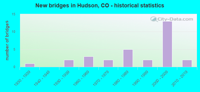
- New bridges - historical statistics
- 11930-1939
- 21950-1959
- 31960-1969
- 21970-1979
- 51980-1989
- 21990-1999
- 132000-2009
- 22010-2019

- Reconstructed bridges - Historical Statistics
- 11970-1979
- 11980-1989
- 01990-1999
- 12000-2009


- Bridge Condition - Deck
- 42.1%Good
- 36.8%Satisfactory
- 15.8%Fair
- 5.3%Poor

- Bridge Condition - Superstructure
- 5.3%Very good
- 47.4%Good
- 31.6%Satisfactory
- 10.5%Fair
- 5.3%Poor

- Bridge Condition - Substructure
- 15.8%Very good
- 47.4%Good
- 31.6%Satisfactory
- 5.3%Fair

- Bridge Condition - Channel
- 70.0%Very good
- 25.0%Good
- 5.0%Satisfactory

- Bridge Condition - Culverts
- 60.0%Good
- 40.0%Satisfactory
Find on map >> Show street view
Structure Number: D-18-B, Location: 3.5 MI E OF JCT I-76 (Lat: 40.073208, Lng: -104.584775), Route carried "on" structure: State highway 52A, Year Built: 1952, Status: Temporarily open, Structure Length: 1.42m (4.66ft), Average Daily Traffic: 2,900 (year 2020), Truck Traffic: 14%, Average Future Daily Traffic: 4,234 (year 2040), Design Load: H 20, Features Intersected: DENVER HUDSON CANAL, Facility Carried by Structure: SH 52 ML
Minimum Vertical Clearance: 30+ m (98+ ft), Kilometerpoint: 52.500, Lanes on structure: 2, Base Highway Network: Yes, Owner: State Highway Agency, Approaching Roadway Width: 7.3m (24.0ft), Skew: 3 degrees, Material/Design: Wood or Timber, Design/Construction: Stringer/Multi-beam, Number Of Spans In Main Unit: 2, Length of Maximum Span: 6.9m (22.6ft), Curb-To-Curb Width: 9.1m (29.9ft), Out-to-Out Width: 9.4m (30.8ft)
Condition: Deck: Poor, Superstructure: Poor, Substructure: Satisfactory, Channel: Very good, Operating Rating: 37.0 metric tons, Method Used To Determine Operating Rating: Allowable Stress (AS), Inventory Rating: 21.5 metric tons, Method Used To Determine Inventory Rating: Allowable Stress (AS), Structural Evaluation: Meets minimum limits, Deck Geometry: Meets minimum limits, Waterway Adequacy: Equal to present desirable criteria, Approach Roadway Alignment: Equal to present desirable criteria, Designated Inspection Frequency: Every 12 months, Inspection Date: March 2021, Deck Structure Type: Wood or Timber, Wearing Surface/Protective System: Wearing Surface: Bituminous
Find on map >> Show street view
Structure Number: D-18-BD, Location: 2.7 MI E OF JCT I-76 (Lat: 40.073161, Lng: -104.597631), Route carried "on" structure: State highway 52A, Year Built: 1965, Status: Open, Structure Length: 0.70m (2.30ft), Average Daily Traffic: 2,900 (year 2020), Truck Traffic: 14%, Average Future Daily Traffic: 4,234 (year 2040), Design Load: HS 20, Features Intersected: BOX ELDER CREEK, Facility Carried by Structure: SH 52 ML
Minimum Vertical Clearance: 30+ m (98+ ft), Kilometerpoint: 51.404, Lanes on structure: 2, Base Highway Network: Yes, Owner: State Highway Agency, Approaching Roadway Width: 7.9m (25.9ft), Skew: 3 degrees, Material/Design: Concrete, Design/Construction: Culvert, Number Of Spans In Main Unit: 1, Length of Maximum Span: 7.0m (23.0ft), Out-to-Out Width: 15.8m (51.8ft)
Condition: Channel: Good, Culverts: Good, Operating Rating: 36.3 metric tons, Method Used To Determine Operating Rating: Field evaluation and documented engineering judgment, Inventory Rating: 32.7 metric tons, Method Used To Determine Inventory Rating: Field evaluation and documented engineering judgment, Structural Evaluation: Better than present minimum criteria, Waterway Adequacy: Better than present minimum criteria, Approach Roadway Alignment: Equal to present desirable criteria, Designated Inspection Frequency: Every 24 months, Inspection Date: March 2021
Find on map >> Show street view
Structure Number: D-18-BO, Location: 5 MI E OF JCT SH 7 (Lat: 40.044583, Lng: -104.671472), Route carried "on" structure: County highway , Year Built: 1983, Status: Posted for load, Structure Length: 14.08m (46.19ft), Average Daily Traffic: 25,000 (year 2018), Average Future Daily Traffic: 115 (year 2025), Design Load: HS 20+Mod, Features Intersected: I 76 ML, BNSF RR, Facility Carried by Structure: COUNTY ROAD 8
Minimum Vertical Clearance: 30+ m (98+ ft), Kilometerpoint: 0.566, Lanes on structure: 2, Lanes under structure: 4, Owner: State Highway Agency, Approaching Roadway Width: 10.4m (34.1ft), Skew: 3 degrees, Material/Design: Steel continuous, Design/Construction: Stringer/Multi-beam, Number Of Spans In Main Unit: 3, Length of Maximum Span: 54.0m (177.2ft), Curb or Sidewalk Widths: Left: 0.4m (1.3ft), Right: 0.4m (1.3ft), Curb-To-Curb Width: 10.4m (34.1ft), Out-to-Out Width: 11.1m (36.4ft)
Condition: Deck: Satisfactory, Superstructure: Good, Substructure: Satisfactory, Operating Rating: 12.6 metric tons, Method Used To Determine Operating Rating: Load Factor (LF), Inventory Rating: 7.1 metric tons, Method Used To Determine Inventory Rating: Load Factor (LF), Structural Evaluation: High priority of corrective action, Deck Geometry: Meets minimum limits, Underclear: Better than present minimum criteria, Approach Roadway Alignment: Equal to present minimum criteria, Bridge Posting: Required (Relationship of Operating Rating to Maximum Legal Load: 20.0 - 29.9% below), Designated Inspection Frequency: Every 24 months, Inspection Date: March 2021, Deck Structure Type: Concrete Cast-file-Place, Wearing Surface/Protective System: Wearing Surface: Bituminous, Membrane: Preformed Fabric
Find on map >> Show street view
Structure Number: D-18-BP, Location: 5.4 MILES NE OF JCT SH 7 (Lat: 40.046153, Lng: -104.670600), Route carried "on" structure: ServiceInterstate 76A, Year Built: 1981, Status: Open, Structure Length: 0.73m (2.40ft), Average Daily Traffic: 23,000 (year 2020), Truck Traffic: 18%, Average Future Daily Traffic: 37,260 (year 2040), Design Load: HS 20, Features Intersected: SEQUINE GULCH SR, Facility Carried by Structure: WEST FRONTAGE ROAD
Minimum Vertical Clearance: 30+ m (98+ ft), Kilometerpoint: 6.399, Lanes on structure: 2, Base Highway Network: Yes, Owner: State Highway Agency, Approaching Roadway Width: 9.1m (29.9ft), Skew: 12 degrees, Material/Design: Concrete, Design/Construction: Culvert, Number Of Spans In Main Unit: 2, Length of Maximum Span: 3.0m (9.8ft), Out-to-Out Width: 18.3m (60.0ft)
Condition: Channel: Very good, Culverts: Good, Operating Rating: 89.8 metric tons, Method Used To Determine Operating Rating: Field evaluation and documented engineering judgment, Inventory Rating: 89.8 metric tons, Method Used To Determine Inventory Rating: Field evaluation and documented engineering judgment, Structural Evaluation: Better than present minimum criteria, Waterway Adequacy: Equal to present desirable criteria, Approach Roadway Alignment: Equal to present desirable criteria, Designated Inspection Frequency: Every 48 months, Inspection Date: January 2019
Find on map >> Show street view
Structure Number: D-18-BQ, Location: 0.2 S OF I76 (Lat: 40.044314, Lng: -104.666297), Route carried "on" structure: ServiceInterstate 76A, Year Built: 1983, Status: Open, Structure Length: 0.73m (2.40ft), Average Daily Traffic: 23,000 (year 2020), Truck Traffic: 18%, Average Future Daily Traffic: 37,260 (year 2040), Design Load: HS 20, Features Intersected: DRAW AR, Facility Carried by Structure: CO RD 8
Minimum Vertical Clearance: 30+ m (98+ ft), Kilometerpoint: 0.248, Lanes on structure: 2, Base Highway Network: Yes, Owner: State Highway Agency, Approaching Roadway Width: 9.1m (29.9ft), Skew: 3 degrees, Material/Design: Concrete, Design/Construction: Culvert, Number Of Spans In Main Unit: 2, Length of Maximum Span: 3.0m (9.8ft), Out-to-Out Width: 18.3m (60.0ft)
Condition: Channel: Good, Culverts: Good, Operating Rating: 36.3 metric tons, Method Used To Determine Operating Rating: Field evaluation and documented engineering judgment, Inventory Rating: 32.7 metric tons, Method Used To Determine Inventory Rating: Field evaluation and documented engineering judgment, Structural Evaluation: Better than present minimum criteria, Waterway Adequacy: Equal to present desirable criteria, Approach Roadway Alignment: Equal to present desirable criteria, Designated Inspection Frequency: Every 48 months, Inspection Date: January 2019
Find on map >> Show street view
Structure Number: D-18-BR, Location: 9.6 MI E OF JCT SH 85 (Lat: 40.074664, Lng: -104.647142), Route carried "on" structure: State highway 52A, Year Built: 2000, Status: Open, Structure Length: 5.59m (18.34ft), Average Daily Traffic: 9,100 (year 2020), Truck Traffic: 14%, Average Future Daily Traffic: 16,107 (year 2040), Design Load: HS 20, Features Intersected: I 76 ML, Facility Carried by Structure: SH 52 ML
Minimum Vertical Clearance: 30+ m (98+ ft), Kilometerpoint: 47.125, Lanes on structure: 3, Lanes under structure: 4, Base Highway Network: Yes, Owner: State Highway Agency, Approaching Roadway Width: 13.4m (44.0ft), Material/Design: Prestressed concrete continuous, Design/Construction: Stringer/Multi-beam, Number Of Spans In Main Unit: 2, Length of Maximum Span: 27.6m (90.6ft), Curb or Sidewalk Widths: Left: 0.0m, Right: 1.5m (4.9ft), Curb-To-Curb Width: 17.9m (58.7ft), Out-to-Out Width: 21.4m (70.2ft)
Condition: Deck: Good, Superstructure: Good, Substructure: Good, Operating Rating: 81.9 metric tons, Method Used To Determine Operating Rating: Load Factor (LF), Inventory Rating: 49.0 metric tons, Method Used To Determine Inventory Rating: Load Factor (LF), Structural Evaluation: Better than present minimum criteria, Deck Geometry: Superior to present desirable criteria, Underclear: Equal to present minimum criteria, Approach Roadway Alignment: Equal to present minimum criteria, Designated Inspection Frequency: Every 24 months, Inspection Date: March 2021, Deck Structure Type: Concrete Precast Panels, Wearing Surface/Protective System: Wearing Surface: Bituminous, Membrane: Preformed Fabric, Deck Protection: Epoxy Coated Reinforcing
Find on map >> Show street view
Structure Number: D-18-BS, Location: 2.4 MI NE OF JCT SH 52 (Lat: 40.098503, Lng: -104.607264), Route carried "on" structure: Interstate 76A, Year Built: 2000, Status: Open, Structure Length: 7.04m (23.10ft), Average Daily Traffic: 10,500 (year 2020), Truck Traffic: 17%, Average Future Daily Traffic: 16,800 (year 2040), Design Load: HS 20, Features Intersected: BOX ELDER CRK FRM ACC. R, Facility Carried by Structure: I 76 ML EBND
Minimum Vertical Clearance: 30+ m (98+ ft), Kilometerpoint: 54.917, Lanes on structure: 3, Lanes under structure: 2, Base Highway Network: Yes, Owner: State Highway Agency, Approaching Roadway Width: 11.6m (38.1ft), Skew: 11 degrees, Material/Design: Prestressed concrete continuous, Design/Construction: Stringer/Multi-beam, Number Of Spans In Main Unit: 3, Length of Maximum Span: 23.0m (75.5ft), Curb-To-Curb Width: 13.8m (45.3ft), Out-to-Out Width: 14.7m (48.2ft)
Condition: Deck: Good, Superstructure: Good, Substructure: Good, Channel: Very good, Inventory Rating: 57.8 metric tons, Method Used To Determine Inventory Rating: Load Factor (LF), Structural Evaluation: Better than present minimum criteria, Deck Geometry: Meets minimum limits, Underclear: High priority of corrective action, Waterway Adequacy: Equal to present desirable criteria, Approach Roadway Alignment: Equal to present desirable criteria, Length Of Structure Improvement: 7.04m (23.10ft), Designated Inspection Frequency: Every 24 months, Inspection Date: Febuary 2021, Bridge Improvement Cost: $1,000, Total Project Cost: $2,000, Deck Structure Type: Concrete Precast Panels, Wearing Surface/Protective System: Wearing Surface: Bituminous, Membrane: Built-up, Deck Protection: Epoxy Coated Reinforcing
Find on map >> Show street view
Structure Number: D-18-BT, Location: 27.9 MI SW OF JCT SH 144 (Lat: 40.098897, Lng: -104.607425), Route carried "on" structure: Interstate 76A, Year Built: 2000, Status: Open, Structure Length: 7.04m (23.10ft), Average Daily Traffic: 10,500 (year 2020), Truck Traffic: 17%, Average Future Daily Traffic: 16,800 (year 2040), Design Load: HS 20, Features Intersected: BOX ELDER CRK FRM. ACCES, Facility Carried by Structure: I 76 ML WBND
Minimum Vertical Clearance: 30+ m (98+ ft), Kilometerpoint: 54.937, Lanes on structure: 3, Lanes under structure: 2, Base Highway Network: Yes, Owner: State Highway Agency, Approaching Roadway Width: 13.8m (45.3ft), Skew: 11 degrees, Material/Design: Prestressed concrete continuous, Design/Construction: Stringer/Multi-beam, Number Of Spans In Main Unit: 3, Length of Maximum Span: 23.0m (75.5ft), Curb-To-Curb Width: 13.8m (45.3ft), Out-to-Out Width: 14.7m (48.2ft)
Condition: Deck: Good, Superstructure: Very good, Substructure: Satisfactory, Channel: Very good, Inventory Rating: 57.8 metric tons, Method Used To Determine Inventory Rating: Load Factor (LF), Structural Evaluation: Equal to present minimum criteria, Deck Geometry: Meets minimum limits, Underclear: High priority of corrective action, Waterway Adequacy: Equal to present desirable criteria, Approach Roadway Alignment: Equal to present desirable criteria, Length Of Structure Improvement: 7.04m (23.10ft), Designated Inspection Frequency: Every 24 months, Inspection Date: Febuary 2021, Bridge Improvement Cost: $1,000, Total Project Cost: $2,000, Deck Structure Type: Concrete Precast Panels, Wearing Surface/Protective System: Wearing Surface: Bituminous, Membrane: Built-up, Deck Protection: Epoxy Coated Reinforcing
Find on map >> Show street view
Structure Number: D-18-BU, Location: 2.8 MI NE OF JCT SH 52 (Lat: 40.101547, Lng: -104.602867), Route carried "on" structure: Interstate 76A, Year Built: 2000, Status: Open, Structure Length: 4.85m (15.91ft), Average Daily Traffic: 10,500 (year 2020), Truck Traffic: 17%, Average Future Daily Traffic: 16,800 (year 2040), Design Load: HS 20, Features Intersected: COUNTY ROAD 49, Facility Carried by Structure: I 76 ML EBND
Minimum Vertical Clearance: 30+ m (98+ ft), Kilometerpoint: 55.423, Lanes on structure: 2, Lanes under structure: 2, Base Highway Network: Yes, Owner: State Highway Agency, Approaching Roadway Width: 11.6m (38.1ft), Skew: 13 degrees, Material/Design: Prestressed concrete continuous, Design/Construction: Stringer/Multi-beam, Number Of Spans In Main Unit: 3, Length of Maximum Span: 9.4m (30.8ft), Curb-To-Curb Width: 11.6m (38.1ft), Out-to-Out Width: 12.5m (41.0ft)
Condition: Deck: Satisfactory, Superstructure: Good, Substructure: Good, Operating Rating: 94.0 metric tons, Method Used To Determine Operating Rating: Load Factor (LF), Inventory Rating: 56.2 metric tons, Method Used To Determine Inventory Rating: Load Factor (LF), Structural Evaluation: Better than present minimum criteria, Deck Geometry: Equal to present minimum criteria, Underclear: Equal to present minimum criteria, Approach Roadway Alignment: Equal to present desirable criteria, Designated Inspection Frequency: Every 24 months, Inspection Date: Febuary 2021, Deck Structure Type: Concrete Precast Panels, Wearing Surface/Protective System: Wearing Surface: Bituminous, Membrane: Built-up, Deck Protection: Epoxy Coated Reinforcing
Find on map >> Show street view
Structure Number: D-18-BV, Location: 4.5 MI W of Keenesburg (Lat: 40.101967, Lng: -104.602911), Route carried "on" structure: Interstate 76A, Year Built: 2000, Status: Open, Structure Length: 4.88m (16.01ft), Average Daily Traffic: 10,500 (year 2020), Truck Traffic: 17%, Average Future Daily Traffic: 16,800 (year 2040), Design Load: HS 20, Features Intersected: COUNTY ROAD 49, Facility Carried by Structure: I 76 ML WBND
Minimum Vertical Clearance: 30+ m (98+ ft), Kilometerpoint: 55.447, Lanes on structure: 2, Lanes under structure: 2, Base Highway Network: Yes, Owner: State Highway Agency, Approaching Roadway Width: 11.6m (38.1ft), Skew: 13 degrees, Material/Design: Prestressed concrete continuous, Design/Construction: Stringer/Multi-beam, Number Of Spans In Main Unit: 3, Length of Maximum Span: 22.0m (72.2ft), Curb-To-Curb Width: 11.6m (38.1ft), Out-to-Out Width: 12.6m (41.3ft)
Condition: Deck: Good, Superstructure: Good, Substructure: Good, Operating Rating: 94.0 metric tons, Method Used To Determine Operating Rating: Load Factor (LF), Inventory Rating: 56.2 metric tons, Method Used To Determine Inventory Rating: Load Factor (LF), Structural Evaluation: Better than present minimum criteria, Deck Geometry: Equal to present minimum criteria, Underclear: Superior to present desirable criteria, Approach Roadway Alignment: Equal to present desirable criteria, Designated Inspection Frequency: Every 24 months, Inspection Date: Febuary 2021, Deck Structure Type: Concrete Precast Panels, Wearing Surface/Protective System: Wearing Surface: Bituminous, Membrane: Preformed Fabric, Deck Protection: Epoxy Coated Reinforcing
Find on map >> Show street view
Structure Number: D-18-BW, Location: 2.4 MI NE OF JCT SH 52 (Lat: 40.098125, Lng: -104.606953), Route carried "on" structure: ServiceInterstate 76A, Year Built: 2000, Status: Open, Structure Length: 7.01m (23.00ft), Average Daily Traffic: 21,000 (year 2020), Truck Traffic: 17%, Average Future Daily Traffic: 33,600 (year 2040), Design Load: HS 20, Features Intersected: BOX ELDER CREEK SR, Facility Carried by Structure: I 76 SERVICE RD
Minimum Vertical Clearance: 30+ m (98+ ft), Kilometerpoint: 2.439, Lanes on structure: 2, Base Highway Network: Yes, Owner: State Highway Agency, Approaching Roadway Width: 7.3m (24.0ft), Skew: 10 degrees, Material/Design: Prestressed concrete continuous, Design/Construction: Stringer/Multi-beam, Number Of Spans In Main Unit: 3, Length of Maximum Span: 23.0m (75.5ft), Curb-To-Curb Width: 8.4m (27.6ft), Out-to-Out Width: 9.3m (30.5ft)
Condition: Deck: Good, Superstructure: Good, Substructure: Good, Channel: Very good, Inventory Rating: 59.8 metric tons, Method Used To Determine Inventory Rating: Load Factor (LF), Structural Evaluation: Better than present minimum criteria, Deck Geometry: High priority of corrective action, Waterway Adequacy: Equal to present desirable criteria, Approach Roadway Alignment: Equal to present desirable criteria, Designated Inspection Frequency: Every 24 months, Inspection Date: Febuary 2021, Deck Structure Type: Concrete Precast Panels, Wearing Surface/Protective System: Wearing Surface: Bituminous, Membrane: Built-up, Deck Protection: Epoxy Coated Reinforcing
Find on map >> Show street view
Structure Number: D-18-B_MINOR, Location: 1.2 MI W OF JCT I 76 (Lat: 40.080481, Lng: -104.667186), Route carried "on" structure: State highway 52A, Year Built: 1970, Status: Open, Structure Length: 0.73m (2.40ft), Average Daily Traffic: 9,100 (year 2020), Truck Traffic: 14%, Average Future Daily Traffic: 16,107 (year 2040), Features Intersected: BEEBE CANAL, Facility Carried by Structure: SH 52 ML
Minimum Vertical Clearance: 30+ m (98+ ft), Kilometerpoint: 45.158, Lanes on structure: 2, Base Highway Network: Yes, Owner: State Highway Agency, Approaching Roadway Width: 8.5m (27.9ft), Material/Design: Steel, Design/Construction: Stringer/Multi-beam, Number Of Spans In Main Unit: 1, Length of Maximum Span: 6.7m (22.0ft), Curb-To-Curb Width: 13.4m (44.0ft), Out-to-Out Width: 14.2m (46.6ft)
Condition: Deck: Good, Superstructure: Good, Substructure: Very good, Channel: Very good, Operating Rating: 50.5 metric tons, Method Used To Determine Operating Rating: Load Factor (LF), Inventory Rating: 30.3 metric tons, Method Used To Determine Inventory Rating: Load Factor (LF), Structural Evaluation: Better than present minimum criteria, Deck Geometry: Equal to present minimum criteria, Waterway Adequacy: Superior to present desirable criteria, Approach Roadway Alignment: Equal to present desirable criteria, Designated Inspection Frequency: Every 24 months, Inspection Date: December 2021, Deck Structure Type: Concrete Cast-file-Place, Wearing Surface/Protective System: Wearing Surface: Bituminous
Find on map >> Show street view
Structure Number: D-18-C, Location: 4.3 MI E OF JCT I-76 (Lat: 40.073200, Lng: -104.567100), Route carried "on" structure: State highway 52A, Year Built: 1952, Status: Open, Structure Length: 1.40m (4.59ft), Average Daily Traffic: 2,900 (year 2020), Truck Traffic: 14%, Average Future Daily Traffic: 4,234 (year 2040), Design Load: H 20, Features Intersected: DENVER HUDSON CANAL, Facility Carried by Structure: SH 52 ML
Minimum Vertical Clearance: 30+ m (98+ ft), Kilometerpoint: 54.008, Lanes on structure: 2, Base Highway Network: Yes, Owner: State Highway Agency, Approaching Roadway Width: 6.7m (22.0ft), Skew: 4 degrees, Material/Design: Wood or Timber, Design/Construction: Stringer/Multi-beam, Number Of Spans In Main Unit: 2, Length of Maximum Span: 6.7m (22.0ft), Curb-To-Curb Width: 9.4m (30.8ft), Out-to-Out Width: 9.8m (32.2ft)
Condition: Deck: Satisfactory, Superstructure: Satisfactory, Substructure: Fair, Channel: Very good, Operating Rating: 36.8 metric tons, Method Used To Determine Operating Rating: Allowable Stress (AS), Inventory Rating: 25.4 metric tons, Method Used To Determine Inventory Rating: Allowable Stress (AS), Structural Evaluation: Somewhat better than minimum adequacy, Deck Geometry: Meets minimum limits, Waterway Adequacy: Equal to present desirable criteria, Approach Roadway Alignment: Equal to present desirable criteria, Designated Inspection Frequency: Every 24 months, Inspection Date: March 2021, Deck Structure Type: Wood or Timber, Wearing Surface/Protective System: Wearing Surface: Bituminous
Find on map >> Show street view
Structure Number: D-18-I, Location: 5.4 MI NE OF JCT SH 7 (Lat: 40.045878, Lng: -104.669347), Route carried "on" structure: Interstate 76A, Year Built: 1935, Year Reconstructed: 1981, Status: Open, Structure Length: 0.64m (2.10ft), Average Daily Traffic: 23,000 (year 2020), Truck Traffic: 18%, Average Future Daily Traffic: 37,260 (year 2040), Design Load: H 15, Features Intersected: SEQUINE GULCH, Facility Carried by Structure: I 76 ML
Minimum Vertical Clearance: 30+ m (98+ ft), Kilometerpoint: 46.850, Lanes on structure: 4, Base Highway Network: Yes, Owner: State Highway Agency, Approaching Roadway Width: 23.2m (76.1ft), Skew: 20 degrees, Material/Design: Concrete, Design/Construction: Culvert, Number Of Spans In Main Unit: 2, Length of Maximum Span: 3.0m (9.8ft), Out-to-Out Width: 44.8m (147.0ft)
Condition: Channel: Very good, Culverts: Satisfactory, Operating Rating: 36.3 metric tons, Method Used To Determine Operating Rating: Allowable Stress (AS), Inventory Rating: 32.7 metric tons, Method Used To Determine Inventory Rating: Allowable Stress (AS), Structural Evaluation: Equal to present minimum criteria, Waterway Adequacy: Equal to present desirable criteria, Approach Roadway Alignment: Equal to present desirable criteria, Designated Inspection Frequency: Every 24 months, Inspection Date: March 2021
Find on map >> Show street view
Structure Number: D-18-P, Location: 3.49 MI NW OF JCT SH 52 (Lat: 40.104750, Lng: -104.593892), Route carried "on" structure: Interstate 76A, Year Built: 1961, Status: Open, Structure Length: 0.88m (2.89ft), Average Daily Traffic: 16,000 (year 2020), Truck Traffic: 19%, Average Future Daily Traffic: 22,560 (year 2040), Design Load: HS 20, Features Intersected: JIM CREEK, Facility Carried by Structure: I 76 ML
Minimum Vertical Clearance: 30+ m (98+ ft), Kilometerpoint: 56.274, Lanes on structure: 6, Base Highway Network: Yes, Owner: State Highway Agency, Approaching Roadway Width: 23.2m (76.1ft), Skew: 13 degrees, Material/Design: Concrete, Design/Construction: Culvert, Number Of Spans In Main Unit: 2, Length of Maximum Span: 4.2m (13.8ft), Out-to-Out Width: 81.2m (266.4ft)
Condition: Channel: Very good, Culverts: Satisfactory, Operating Rating: 36.3 metric tons, Method Used To Determine Operating Rating: Field evaluation and documented engineering judgment, Inventory Rating: 32.7 metric tons, Method Used To Determine Inventory Rating: Field evaluation and documented engineering judgment, Structural Evaluation: Equal to present minimum criteria, Waterway Adequacy: Equal to present desirable criteria, Approach Roadway Alignment: Equal to present desirable criteria, Designated Inspection Frequency: Every 24 months, Inspection Date: Febuary 2021
Find on map >> Show street view
Structure Number: WEL004.0_045.0A, Location: 0.5 Mi E of Co Rd 45 (Lat: 40.015047, Lng: -104.631414), Route carried "on" structure: County highway , Year Built: 2003, Status: Open, Structure Length: 1.17m (3.84ft), Average Daily Traffic: 624 (year 2020), Truck Traffic: 36%, Average Future Daily Traffic: 886 (year 2040), Design Load: HS 20, Features Intersected: Denver Hudson Canal, Facility Carried by Structure: County Road 4
Minimum Vertical Clearance: 30+ m (98+ ft), Kilometerpoint: 5.362, Lanes on structure: 2, Owner: County Highway Agency, Approaching Roadway Width: 6.1m (20.0ft), Material/Design: Steel, Design/Construction: Stringer/Multi-beam, Number Of Spans In Main Unit: 1, Length of Maximum Span: 11.1m (36.4ft), Curb-To-Curb Width: 9.5m (31.2ft), Out-to-Out Width: 9.8m (32.2ft)
Condition: Deck: Satisfactory, Superstructure: Satisfactory, Substructure: Good, Channel: Very good, Operating Rating: 45.4 metric tons, Method Used To Determine Operating Rating: Load Factor (LF), Inventory Rating: 27.2 metric tons, Method Used To Determine Inventory Rating: Load Factor (LF), Structural Evaluation: Equal to present minimum criteria, Deck Geometry: Equal to present minimum criteria, Waterway Adequacy: Equal to present desirable criteria, Approach Roadway Alignment: Equal to present desirable criteria, Designated Inspection Frequency: Every 24 months, Inspection Date: Febuary 2022, Deck Structure Type: Corrugated Steel, Wearing Surface/Protective System: Wearing Surface: Bituminous
Find on map >> Show street view
Structure Number: WEL008.0-041.0A, Location: 0.1 Mi E of CR 41 (Lat: 40.044306, Lng: -104.681417), Route carried "on" structure: County highway , Year Built: 2006, Status: Open, Structure Length: 1.79m (5.87ft), Average Daily Traffic: 2,357 (year 2020), Truck Traffic: 37%, Average Future Daily Traffic: 3,347 (year 2040), Design Load: HS 20, Features Intersected: Beebe Seep Canal, Facility Carried by Structure: County Road 8
Minimum Vertical Clearance: 30+ m (98+ ft), Kilometerpoint: 9.215, Lanes on structure: 2, Owner: County Highway Agency, Approaching Roadway Width: 7.3m (24.0ft), Skew: 1 degrees, Material/Design: Steel, Design/Construction: Stringer/Multi-beam, Number Of Spans In Main Unit: 1, Length of Maximum Span: 17.1m (56.1ft), Curb-To-Curb Width: 10.3m (33.8ft), Out-to-Out Width: 10.6m (34.8ft)
Condition: Deck: Satisfactory, Superstructure: Satisfactory, Substructure: Good, Channel: Satisfactory, Operating Rating: 36.0 metric tons, Method Used To Determine Operating Rating: Load Factor (LF), Inventory Rating: 21.6 metric tons, Method Used To Determine Inventory Rating: Load Factor (LF), Structural Evaluation: Somewhat better than minimum adequacy, Deck Geometry: Meets minimum limits, Waterway Adequacy: Equal to present desirable criteria, Approach Roadway Alignment: Equal to present desirable criteria, Designated Inspection Frequency: Every 24 months, Inspection Date: Febuary 2022, Deck Structure Type: Corrugated Steel, Wearing Surface/Protective System: Wearing Surface: Bituminous
Find on map >> Show street view
Structure Number: WEL008.0-043.0A, Location: 1.4 Mi E of Co Rd 41 (Lat: 40.044192, Lng: -104.651953), Route carried "on" structure: County highway , Year Built: 1974, Year Reconstructed: 1993, Status: Open, Structure Length: 0.92m (3.02ft), Average Daily Traffic: 1,105 (year 2020), Truck Traffic: 30%, Average Future Daily Traffic: 1,569 (year 2040), Design Load: HS 20, Features Intersected: Neres Canal, Facility Carried by Structure: County Road 8
Minimum Vertical Clearance: 30+ m (98+ ft), Kilometerpoint: 1.045, Lanes on structure: 2, Owner: County Highway Agency, Approaching Roadway Width: 7.0m (23.0ft), Material/Design: Steel, Design/Construction: Stringer/Multi-beam, Number Of Spans In Main Unit: 1, Length of Maximum Span: 8.5m (27.9ft), Curb-To-Curb Width: 9.6m (31.5ft), Out-to-Out Width: 9.7m (31.8ft)
Condition: Deck: Fair, Superstructure: Fair, Substructure: Satisfactory, Channel: Good, Operating Rating: 44.7 metric tons, Method Used To Determine Operating Rating: Load Factor (LF), Inventory Rating: 26.9 metric tons, Method Used To Determine Inventory Rating: Load Factor (LF), Structural Evaluation: Somewhat better than minimum adequacy, Deck Geometry: Somewhat better than minimum adequacy, Waterway Adequacy: Equal to present desirable criteria, Approach Roadway Alignment: Equal to present desirable criteria, Designated Inspection Frequency: Every 24 months, Inspection Date: Febuary 2022, Deck Structure Type: Corrugated Steel, Wearing Surface/Protective System: Wearing Surface: Bituminous
Find on map >> Show street view
Structure Number: WEL010.0-051.0A, Location: 0.1 Mi E of Co Rd 51 (Lat: 40.058889, Lng: -104.579000), Route carried "on" structure: County highway , Year Built: 1982, Status: Open, Structure Length: 1.19m (3.90ft), Average Daily Traffic: 74 (year 2020), Truck Traffic: 47%, Average Future Daily Traffic: 105 (year 2040), Design Load: HS 20, Features Intersected: Denver Hudson Canal, Facility Carried by Structure: County Road 10
Minimum Vertical Clearance: 30+ m (98+ ft), Kilometerpoint: 0.459, Lanes on structure: 2, Owner: County Highway Agency, Approaching Roadway Width: 7.6m (24.9ft), Skew: 4 degrees, Material/Design: Steel, Design/Construction: Stringer/Multi-beam, Number Of Spans In Main Unit: 1, Length of Maximum Span: 10.9m (35.8ft), Curb-To-Curb Width: 9.5m (31.2ft), Out-to-Out Width: 9.7m (31.8ft)
Condition: Deck: Satisfactory, Superstructure: Satisfactory, Substructure: Satisfactory, Channel: Good, Operating Rating: 34.3 metric tons, Method Used To Determine Operating Rating: Load Factor (LF), Inventory Rating: 20.6 metric tons, Method Used To Determine Inventory Rating: Load Factor (LF), Structural Evaluation: Somewhat better than minimum adequacy, Deck Geometry: Better than present minimum criteria, Waterway Adequacy: Equal to present desirable criteria, Approach Roadway Alignment: Equal to present desirable criteria, Designated Inspection Frequency: Every 24 months, Inspection Date: Febuary 2022, Deck Structure Type: Corrugated Steel, Wearing Surface/Protective System: Wearing Surface: Gravel
Find on map >> Show street view
Structure Number: WEL022.0_043.0A, Location: 1.5 Mi E of Co Rd 41 (Lat: 40.145944, Lng: -104.650167), Route carried "on" structure: County highway , Year Built: 1994, Year Reconstructed: 2011, Status: Open, Structure Length: 1.25m (4.10ft), Average Daily Traffic: 2,671 (year 2020), Truck Traffic: 32%, Average Future Daily Traffic: 3,793 (year 2040), Design Load: HS 20, Features Intersected: Beebe Seep Canal, Facility Carried by Structure: County Road 22
Minimum Vertical Clearance: 30+ m (98+ ft), Kilometerpoint: 13.702, Lanes on structure: 2, Owner: County Highway Agency, Approaching Roadway Width: 7.3m (24.0ft), Material/Design: Steel, Design/Construction: Stringer/Multi-beam, Number Of Spans In Main Unit: 1, Length of Maximum Span: 11.6m (38.1ft), Curb-To-Curb Width: 9.4m (30.8ft), Out-to-Out Width: 9.8m (32.2ft)
Condition: Deck: Satisfactory, Superstructure: Satisfactory, Substructure: Satisfactory, Channel: Good, Operating Rating: 39.1 metric tons, Method Used To Determine Operating Rating: Load and Resistance Factor (LRFR), Inventory Rating: 30.2 metric tons, Method Used To Determine Inventory Rating: Load and Resistance Factor (LRFR), Structural Evaluation: Equal to present minimum criteria, Deck Geometry: Meets minimum limits, Waterway Adequacy: Equal to present desirable criteria, Approach Roadway Alignment: Equal to present desirable criteria, Designated Inspection Frequency: Every 24 months, Inspection Date: April 2020, Deck Structure Type: Corrugated Steel, Wearing Surface/Protective System: Wearing Surface: Bituminous
Find on map >> Show street view
Structure Number: WEL045.0-006.0A, Location: 1.0 Mi N of Co Rd 6 (Lat: 40.030258, Lng: -104.640800), Route carried "on" structure: County highway , Year Built: 1969, Status: Open, Structure Length: 1.26m (4.13ft), Average Daily Traffic: 2,209 (year 2020), Truck Traffic: 31%, Average Future Daily Traffic: 3,137 (year 2040), Design Load: HS 20, Features Intersected: Hudson Annex Canal, Facility Carried by Structure: County Road 45
Minimum Vertical Clearance: 30+ m (98+ ft), Kilometerpoint: 3.255, Lanes on structure: 2, Owner: County Highway Agency, Approaching Roadway Width: 7.6m (24.9ft), Material/Design: Prestressed concrete, Design/Construction: Tee Beam, Number Of Spans In Main Unit: 1, Length of Maximum Span: 12.0m (39.4ft), Curb-To-Curb Width: 8.3m (27.2ft), Out-to-Out Width: 8.5m (27.9ft)
Condition: Deck: Fair, Superstructure: Fair, Substructure: Good, Channel: Very good, Operating Rating: 36.3 metric tons, Method Used To Determine Operating Rating: Field evaluation and documented engineering judgment, Inventory Rating: 32.7 metric tons, Method Used To Determine Inventory Rating: Field evaluation and documented engineering judgment, Structural Evaluation: Somewhat better than minimum adequacy, Deck Geometry: High priority of corrective action, Waterway Adequacy: Equal to present desirable criteria, Approach Roadway Alignment: Equal to present desirable criteria, Designated Inspection Frequency: Every 24 months, Inspection Date: Febuary 2022, Deck Structure Type: Other, Wearing Surface/Protective System: Wearing Surface: Bituminous
Find on map >> Show street view
Structure Number: WEL045.0_008.0A, Location: 0.4 Mi North of Co Rd 8 (Lat: 40.050650, Lng: -104.640622), Route carried "on" structure: County highway , Year Built: 1998, Status: Open, Structure Length: 1.22m (4.00ft), Average Daily Traffic: 2,076 (year 2020), Truck Traffic: 31%, Average Future Daily Traffic: 2,948 (year 2040), Design Load: HS 20, Features Intersected: Neres Canal, Facility Carried by Structure: County Road 45
Minimum Vertical Clearance: 30+ m (98+ ft), Kilometerpoint: 5.587, Lanes on structure: 2, Owner: County Highway Agency, Approaching Roadway Width: 7.6m (24.9ft), Material/Design: Steel, Design/Construction: Stringer/Multi-beam, Number Of Spans In Main Unit: 1, Length of Maximum Span: 11.7m (38.4ft), Curb-To-Curb Width: 9.7m (31.8ft), Out-to-Out Width: 9.8m (32.2ft)
Condition: Deck: Fair, Superstructure: Satisfactory, Substructure: Good, Channel: Very good, Operating Rating: 49.8 metric tons, Method Used To Determine Operating Rating: Load Factor (LF), Inventory Rating: 29.8 metric tons, Method Used To Determine Inventory Rating: Load Factor (LF), Structural Evaluation: Equal to present minimum criteria, Deck Geometry: Meets minimum limits, Waterway Adequacy: Equal to present desirable criteria, Approach Roadway Alignment: Equal to present desirable criteria, Designated Inspection Frequency: Every 24 months, Inspection Date: Febuary 2022, Deck Structure Type: Corrugated Steel, Wearing Surface/Protective System: Wearing Surface: Bituminous
Find on map >> Show street view
Structure Number: WEL049.0-016.0A, Location: 0.5 mi N of I-76 (Lat: 40.110833, Lng: -104.602861), Route carried "on" structure: County highway , Year Built: 2017, Status: Open, Structure Length: 1.39m (4.56ft), Average Daily Traffic: 12,677 (year 2020), Truck Traffic: 48%, Average Future Daily Traffic: 18,001 (year 2040), Design Load: HL 93, Features Intersected: Jim Creek, Facility Carried by Structure: County Road 49
Minimum Vertical Clearance: 30+ m (98+ ft), Kilometerpoint: 5.270, Lanes on structure: 5, Owner: County Highway Agency, Approaching Roadway Width: 24.4m (80.1ft), Skew: 3 degrees, Material/Design: Prestressed concrete, Design/Construction: Box Beam or Girders - Multiple, Number Of Spans In Main Unit: 1, Length of Maximum Span: 11.5m (37.7ft), Curb-To-Curb Width: 24.4m (80.1ft), Out-to-Out Width: 25.3m (83.0ft)
Condition: Deck: Good, Superstructure: Good, Substructure: Very good, Channel: Very good, Operating Rating: 55.1 metric tons, Method Used To Determine Operating Rating: Load and Resistance Factor Rating (LRFR) rating reported by rating factor(RF) method using HL-93 loadings, Inventory Rating: 42.1 metric tons, Method Used To Determine Inventory Rating: Load and Resistance Factor Rating (LRFR) rating reported by rating factor(RF) method using HL-93 loadings, Structural Evaluation: Better than present minimum criteria, Deck Geometry: Superior to present desirable criteria, Waterway Adequacy: Equal to present desirable criteria, Approach Roadway Alignment: Equal to present desirable criteria, Designated Inspection Frequency: Every 24 months, Inspection Date: Febuary 2022, Deck Structure Type: Concrete Cast-file-Place, Wearing Surface/Protective System: Wearing Surface: Bituminous, Deck Protection: Epoxy Coated Reinforcing
Find on map >> Show street view
Structure Number: WEL049.0-024.0A, Location: 1.3 MI N of CR 22 (Lat: 40.164322, Lng: -104.602897), Route carried "on" structure: County highway , Year Built: 2017, Status: Open, Structure Length: 5.63m (18.47ft), Average Daily Traffic: 11,750 (year 2020), Truck Traffic: 38%, Average Future Daily Traffic: 16,685 (year 2040), Design Load: HL 93, Features Intersected: Box Elder Creek, Facility Carried by Structure: County Road 49
Minimum Vertical Clearance: 30+ m (98+ ft), Kilometerpoint: 5.270, Lanes on structure: 5, Owner: County Highway Agency, Approaching Roadway Width: 24.4m (80.1ft), Material/Design: Prestressed concrete, Design/Construction: Box Beam or Girders - Multiple, Number Of Spans In Main Unit: 4, Length of Maximum Span: 12.9m (42.3ft), Curb-To-Curb Width: 24.4m (80.1ft), Out-to-Out Width: 25.3m (83.0ft)
Condition: Deck: Good, Superstructure: Good, Substructure: Very good, Channel: Very good, Operating Rating: 51.8 metric tons, Method Used To Determine Operating Rating: Load and Resistance Factor Rating (LRFR) rating reported by rating factor(RF) method using HL-93 loadings, Inventory Rating: 38.9 metric tons, Method Used To Determine Inventory Rating: Load and Resistance Factor Rating (LRFR) rating reported by rating factor(RF) method using HL-93 loadings, Structural Evaluation: Better than present minimum criteria, Deck Geometry: Superior to present desirable criteria, Waterway Adequacy: Equal to present desirable criteria, Approach Roadway Alignment: Equal to present desirable criteria, Designated Inspection Frequency: Every 24 months, Inspection Date: Febuary 2022, Deck Structure Type: Concrete Cast-file-Place, Wearing Surface/Protective System: Wearing Surface: Bituminous, Deck Protection: Epoxy Coated Reinforcing
Find on map >> Show street view
Structure Number: D-18-BO, Location: 5 MI E OF JCT SH 7 (Lat: 40.044583, Lng: -104.671472), Route carried "under" structure: Interstate 76A, Year Built: 1983, Structure Length: 0. m, Average Daily Traffic: 25,000 (year 2018), Truck Traffic: 18%, Features Intersected: I 76 ML, BNSF RR, Facility Carried by Structure: COUNTY ROAD 8
Minimum Vertical Clearance: 9.14m (29.99ft), Kilometerpoint: 0.566, Lanes on structure: 2, Lanes under structure: 4, Material/Design: Steel continuous, Design/Construction: Stringer/Multi-beam, Length of Maximum Span: 54.0m (177.2ft)
Find on map >> Show street view
Structure Number: D-18-BR, Location: 9.6 MI E OF JCT SH 85 (Lat: 40.074664, Lng: -104.647142), Route carried "under" structure: Interstate 76A, Year Built: 2000, Structure Length: 0. m, Average Daily Traffic: 8,800 (year 2018), Truck Traffic: 17%, Features Intersected: I 76 ML, Facility Carried by Structure: SH 52 ML
Minimum Vertical Clearance: 5.54m (18.18ft), Kilometerpoint: 47.126, Lanes on structure: 3, Lanes under structure: 4, Material/Design: Prestressed concrete continuous, Design/Construction: Stringer/Multi-beam, Length of Maximum Span: 27.6m (90.6ft)
Find on map >> Show street view
Structure Number: D-18-BS, Location: 2.4 MI NE OF JCT SH 52 (Lat: 40.098503, Lng: -104.607264), Route carried "under" structure: ServiceOther road , Year Built: 2000, Structure Length: 0. m, Average Daily Traffic: 100 (year 2016), Truck Traffic: 20%, Features Intersected: BOX ELDER CRK FRM ACC. R, Facility Carried by Structure: I 76 ML EBND
Minimum Vertical Clearance: 3.20m (10.50ft), Kilometerpoint: 0.000, Lanes on structure: 3, Lanes under structure: 2, Material/Design: Prestressed concrete continuous, Design/Construction: Stringer/Multi-beam, Length of Maximum Span: 23.0m (75.5ft)
Find on map >> Show street view
Structure Number: D-18-BT, Location: 27.9 MI SW OF JCT SH 144 (Lat: 40.098897, Lng: -104.607425), Route carried "under" structure: Other road , Year Built: 2000, Structure Length: 0. m, Average Daily Traffic: 1,000 (year 2018), Truck Traffic: 1%, Features Intersected: BOX ELDER CRK FRM. ACCES, Facility Carried by Structure: I 76 ML WBND
Minimum Vertical Clearance: 16.93m (55.54ft), Kilometerpoint: 0.000, Lanes on structure: 3, Lanes under structure: 2, Material/Design: Prestressed concrete continuous, Design/Construction: Stringer/Multi-beam, Length of Maximum Span: 23.0m (75.5ft)
Find on map >> Show street view
Structure Number: D-18-BU, Location: 2.8 MI NE OF JCT SH 52 (Lat: 40.101547, Lng: -104.602867), Route carried "under" structure: County highway , Year Built: 2000, Structure Length: 0. m, Average Daily Traffic: 1,000 (year 2018), Truck Traffic: 1%, Features Intersected: COUNTY ROAD 49, Facility Carried by Structure: I 76 ML EBND
Minimum Vertical Clearance: 16.93m (55.54ft), Kilometerpoint: 0.000, Lanes on structure: 2, Lanes under structure: 2, Material/Design: Prestressed concrete continuous, Design/Construction: Stringer/Multi-beam, Length of Maximum Span: 9.4m (30.8ft)
Find on map >> Show street view
Structure Number: D-18-BV, Location: 4.5 MI W of Keenesburg (Lat: 40.101967, Lng: -104.602911), Route carried "under" structure: _, Year Built: 2000, Structure Length: 0. m, Features Intersected: COUNTY ROAD 49, Facility Carried by Structure: I 76 ML WBND
Minimum Vertical Clearance: 5.05m (16.57ft), Kilometerpoint: 0.000, Lanes on structure: 2, Lanes under structure: 2, Material/Design: Prestressed concrete continuous, Design/Construction: Stringer/Multi-beam, Length of Maximum Span: 22.0m (72.2ft)