Bridge Statistics for Hudson Lake, Indiana (IN)
Condition, Traffic, Stress, Structural Evaluation, Project Costs
- National Bridge Inventory (NBI) Statistics
- 11Number of bridges
- 89ft / 27.1mTotal length
- 68,442Total average daily traffic
- 12,343Total average daily truck traffic
- National Bridge Inventory (NBI) Registered Bridges for Hudson Lake
- No street view available for this location
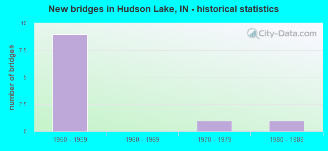
- New bridges - historical statistics
- 91950-1959
- 11970-1979
- 11980-1989

- Reconstructed bridges - Historical Statistics
- 11980-1989
- 11990-1999
- 02000-2009
- 22010-2019


- Bridge Condition - Deck
- 33.3%Excellent
- 50.0%Satisfactory
- 16.7%Fair

- Bridge Condition - Superstructure
- 50.0%Good
- 33.3%Satisfactory
- 16.7%Fair
Find on map >> Show street view
Structure Number: 4745, Location: 08.60 E SR 39 (Lat: 41.723619, Lng: -86.602875), Route carried "on" structure: County highway 500, Year Built: 1956, Year Reconstructed: 1998, Status: Open, Structure Length: 9.30m (30.51ft), Average Daily Traffic: 591 (year 2014), Truck Traffic: 10%, Average Future Daily Traffic: 1,407 (year 2031), Design Load: HS 20, Features Intersected: I-90 EB/WB
Minimum Vertical Clearance: 30+ m (98+ ft), Kilometerpoint: 0.000, Lanes on structure: 2, Lanes under structure: 4, Owner: State Toll Authority, Approaching Roadway Width: 9.1m (29.9ft), Skew: 4 degrees, Material/Design: Steel continuous, Design/Construction: Stringer/Multi-beam, Number Of Spans In Main Unit: 5, Length of Maximum Span: 21.5m (70.5ft), Curb or Sidewalk Widths: Left: 0.3m (1.0ft), Right: 0.3m (1.0ft), Curb-To-Curb Width: 7.9m (25.9ft), Out-to-Out Width: 9.1m (29.9ft)
Condition: Deck: Satisfactory, Superstructure: Satisfactory, Substructure: Good, Operating Rating: 40.5 metric tons, Method Used To Determine Operating Rating: Load and Resistance Factor Rating (LRFR) rating reported by rating factor(RF) method using HL-93 loadings, Inventory Rating: 31.1 metric tons, Method Used To Determine Inventory Rating: Load and Resistance Factor Rating (LRFR) rating reported by rating factor(RF) method using HL-93 loadings, Structural Evaluation: Equal to present minimum criteria, Deck Geometry: Somewhat better than minimum adequacy, Underclear: Somewhat better than minimum adequacy, Approach Roadway Alignment: Equal to present minimum criteria, Designated Inspection Frequency: Every 24 months, Other Special Inspection Frequency: Every 24 months, Inspection Date: July 2021, Other Special Inspection Date: July 2021, Deck Structure Type: Concrete Cast-file-Place, Wearing Surface/Protective System: Wearing Surface: Latex Concrete
Find on map >> Show street view
Structure Number: 4746, Location: 09.66 E SR 39 (Lat: 41.726631, Lng: -86.583450), Route carried "on" structure: Interstate 90, Year Built: 1956, Year Reconstructed: 2018, Status: Open, Structure Length: 3.57m (11.71ft), Average Daily Traffic: 13,580 (year 2015), Truck Traffic: 24%, Average Future Daily Traffic: 26,252 (year 2031), Design Load: HS 20+Mod, Features Intersected: HUNTS ROAD
Minimum Vertical Clearance: 30+ m (98+ ft), Kilometerpoint: 94.243, Lanes on structure: 2, Lanes under structure: 2, Base Highway Network: Yes (, Subroute: 1), Toll: On toll road, Owner: State Toll Authority, Approaching Roadway Width: 12.8m (42.0ft), Material/Design: Steel, Design/Construction: Stringer/Multi-beam, Number Of Spans In Main Unit: 3, Length of Maximum Span: 10.1m (33.1ft), Curb-To-Curb Width: 11.5m (37.7ft), Out-to-Out Width: 12.4m (40.7ft)
Condition: Deck: Excellent, Superstructure: Good, Substructure: Good, Operating Rating: 97.9 metric tons, Method Used To Determine Operating Rating: Load Factor (LF), Inventory Rating: 58.6 metric tons, Method Used To Determine Inventory Rating: Load Factor (LF), Structural Evaluation: Better than present minimum criteria, Deck Geometry: Somewhat better than minimum adequacy, Underclear: Meets minimum limits, Approach Roadway Alignment: Equal to present desirable criteria, Designated Inspection Frequency: Every 24 months, Inspection Date: July 2021, Deck Structure Type: Concrete Cast-file-Place, Wearing Surface/Protective System: Wearing Surface: Latex Concrete
Find on map >> Show street view
Structure Number: 4747, Location: 09.66 E SR 39 (Lat: 41.726839, Lng: -86.583458), Route carried "on" structure: Interstate 90, Year Built: 1956, Year Reconstructed: 2018, Status: Open, Structure Length: 3.57m (11.71ft), Average Daily Traffic: 12,966 (year 2011), Truck Traffic: 24%, Average Future Daily Traffic: 26,252 (year 2031), Design Load: HS 20+Mod, Features Intersected: HUNTS ROAD
Minimum Vertical Clearance: 30+ m (98+ ft), Kilometerpoint: 94.243, Lanes on structure: 2, Lanes under structure: 2, Base Highway Network: Yes (, Subroute: 1), Toll: On toll road, Owner: State Toll Authority, Approaching Roadway Width: 12.8m (42.0ft), Skew: 1 degrees, Material/Design: Steel, Design/Construction: Stringer/Multi-beam, Number Of Spans In Main Unit: 3, Length of Maximum Span: 10.1m (33.1ft), Curb-To-Curb Width: 11.5m (37.7ft), Out-to-Out Width: 12.4m (40.7ft)
Condition: Deck: Excellent, Superstructure: Good, Substructure: Good, Operating Rating: 97.9 metric tons, Method Used To Determine Operating Rating: Load Factor (LF), Inventory Rating: 58.6 metric tons, Method Used To Determine Inventory Rating: Load Factor (LF), Structural Evaluation: Better than present minimum criteria, Deck Geometry: Somewhat better than minimum adequacy, Underclear: High priority of corrective action, Approach Roadway Alignment: Equal to present desirable criteria, Designated Inspection Frequency: Every 24 months, Inspection Date: July 2021, Deck Structure Type: Concrete Cast-file-Place, Wearing Surface/Protective System: Wearing Surface: Latex Concrete
Find on map >> Show street view
Structure Number: 4751, Location: 12.93 E SR 39 (Lat: 41.742161, Lng: -86.524467), Route carried "on" structure: Interstate 90, Year Built: 1956, Year Reconstructed: 1985, Status: Open, Structure Length: 3.57m (11.71ft), Average Daily Traffic: 12,966 (year 2011), Truck Traffic: 24%, Average Future Daily Traffic: 26,252 (year 2031), Design Load: HS 20, Features Intersected: CR 900 E
Minimum Vertical Clearance: 30+ m (98+ ft), Kilometerpoint: 99.506, Lanes on structure: 2, Lanes under structure: 2, Base Highway Network: Yes (, Subroute: 1), Toll: On toll road, Owner: State Toll Authority, Approaching Roadway Width: 12.8m (42.0ft), Skew: 1 degrees, Material/Design: Steel, Design/Construction: Stringer/Multi-beam, Number Of Spans In Main Unit: 3, Length of Maximum Span: 10.4m (34.1ft), Curb-To-Curb Width: 9.8m (32.2ft), Out-to-Out Width: 10.7m (35.1ft)
Condition: Deck: Satisfactory, Superstructure: Satisfactory, Substructure: Good, Operating Rating: 62.0 metric tons, Method Used To Determine Operating Rating: Load Factor (LF), Inventory Rating: 37.1 metric tons, Method Used To Determine Inventory Rating: Load Factor (LF), Structural Evaluation: Equal to present minimum criteria, Deck Geometry: High priority of replacement, Underclear: High priority of corrective action, Approach Roadway Alignment: Equal to present desirable criteria, Designated Inspection Frequency: Every 24 months, Inspection Date: July 2021, Deck Structure Type: Concrete Cast-file-Place, Wearing Surface/Protective System: Wearing Surface: Latex Concrete
Find on map >> Show street view
Structure Number: 4600124, Location: 00.30 N CR 700 N (Lat: 41.713011, Lng: -86.569819), Route carried "on" structure: County highway , Year Built: 1976, Status: Open, Structure Length: 5.36m (17.59ft), Average Daily Traffic: 500 (year 2020), Truck Traffic: 5%, Average Future Daily Traffic: 750 (year 2040), Design Load: HS 20, Features Intersected: NICTD RR, Facility Carried by Structure: EMERY ROAD
Minimum Vertical Clearance: 30+ m (98+ ft), Kilometerpoint: 0.000, Lanes on structure: 2, Owner: County Highway Agency, Approaching Roadway Width: 8.5m (27.9ft), Skew: 2 degrees, Material/Design: Steel continuous, Design/Construction: Stringer/Multi-beam, Number Of Spans In Main Unit: 3, Length of Maximum Span: 19.4m (63.6ft), Curb-To-Curb Width: 8.5m (27.9ft), Out-to-Out Width: 9.4m (30.8ft)
Condition: Deck: Satisfactory, Superstructure: Good, Substructure: Good, Operating Rating: 62.4 metric tons, Method Used To Determine Operating Rating: Load Factor (LF), Inventory Rating: 37.4 metric tons, Method Used To Determine Inventory Rating: Load Factor (LF), Structural Evaluation: Better than present minimum criteria, Deck Geometry: Somewhat better than minimum adequacy, Underclear: Equal to present minimum criteria, Approach Roadway Alignment: Equal to present minimum criteria, Designated Inspection Frequency: Every 24 months, Inspection Date: September 2020, Deck Structure Type: Concrete Cast-file-Place, Wearing Surface/Protective System: Wearing Surface: Bituminous, Membrane: Preformed Fabric
Find on map >> Show street view
Structure Number: 4600154, Location: 00.40 W CR 500 E (Lat: 41.738931, Lng: -86.610589), Route carried "on" structure: County highway 276, Year Built: 1980, Status: Open, Structure Length: 1.77m (5.81ft), Average Daily Traffic: 100 (year 2020), Truck Traffic: 5%, Average Future Daily Traffic: 150 (year 2040), Design Load: HS 20, Features Intersected: TRIBUTARY GALENA RIVER, Facility Carried by Structure: CR 900N
Minimum Vertical Clearance: 30+ m (98+ ft), Kilometerpoint: 0.000, Lanes on structure: 2, Owner: County Highway Agency, Approaching Roadway Width: 6.1m (20.0ft), Material/Design: Prestressed concrete, Design/Construction: Box Beam or Girders - Multiple, Number Of Spans In Main Unit: 1, Length of Maximum Span: 16.9m (55.4ft), Curb-To-Curb Width: 7.2m (23.6ft), Out-to-Out Width: 7.4m (24.3ft)
Condition: Deck: Fair, Superstructure: Fair, Substructure: Good, Channel: Good, Operating Rating: 53.5 metric tons, Method Used To Determine Operating Rating: Load Factor (LF), Inventory Rating: 32.0 metric tons, Method Used To Determine Inventory Rating: Load Factor (LF), Structural Evaluation: Somewhat better than minimum adequacy, Deck Geometry: Somewhat better than minimum adequacy, Waterway Adequacy: Better than present minimum criteria, Approach Roadway Alignment: Equal to present minimum criteria, Designated Inspection Frequency: Every 24 months, Inspection Date: September 2020, Deck Structure Type: Concrete Precast Panels, Wearing Surface/Protective System: Wearing Surface: Bituminous
Find on map >> Show street view
Structure Number: 4745, Location: 08.60 E SR 39 (Lat: 41.723619, Lng: -86.602875), Route carried "under" structure: Interstate 90, Year Built: 1956, Structure Length: 0. m, Average Daily Traffic: 13,580 (year 2015), Truck Traffic: 10%, Features Intersected: I-90 EB, Facility Carried by Structure: CR 500E/NOVITIATE
Minimum Vertical Clearance: 4.98m (16.34ft), Kilometerpoint: 92.537, Lanes on structure: 2, Lanes under structure: 2, Toll: On toll road, Material/Design: Steel continuous, Design/Construction: Stringer/Multi-beam, Length of Maximum Span: 21.5m (70.5ft)
Find on map >> Show street view
Structure Number: 4745, Location: 08.60 E SR 39 (Lat: 41.723619, Lng: -86.602875), Route carried "under" structure: Interstate 90, Year Built: 1956, Structure Length: 0. m, Average Daily Traffic: 13,580 (year 2015), Truck Traffic: 10%, Features Intersected: I-90 WB, Facility Carried by Structure: CR 500E/NOVITIATE
Minimum Vertical Clearance: 4.98m (16.34ft), Kilometerpoint: 92.537, Lanes on structure: 2, Lanes under structure: 2, Toll: On toll road, Material/Design: Steel continuous, Design/Construction: Stringer/Multi-beam, Length of Maximum Span: 21.5m (70.5ft)
Find on map >> Show street view
Structure Number: 4746, Location: 09.66 E SR 39 (Lat: 41.726631, Lng: -86.583450), Route carried "under" structure: County highway , Year Built: 1956, Structure Length: 0. m, Average Daily Traffic: 143 (year 2015), Truck Traffic: 10%, Features Intersected: HUNTS RD, Facility Carried by Structure: I-90 EB
Minimum Vertical Clearance: 4.29m (14.07ft), Kilometerpoint: 0.000, Lanes on structure: 2, Lanes under structure: 2, Material/Design: Steel, Design/Construction: Stringer/Multi-beam, Length of Maximum Span: 10.1m (33.1ft)
Find on map >> Show street view
Structure Number: 4747, Location: 09.66 E SR 39 (Lat: 41.726839, Lng: -86.583458), Route carried "under" structure: County highway , Year Built: 1956, Structure Length: 0. m, Average Daily Traffic: 143 (year 2004), Truck Traffic: 10%, Features Intersected: HUNTS ROAD, Facility Carried by Structure: I-90 WB
Minimum Vertical Clearance: 4.17m (13.68ft), Kilometerpoint: 0.000, Lanes on structure: 2, Lanes under structure: 2, Toll: On toll road, Material/Design: Steel, Design/Construction: Stringer/Multi-beam, Length of Maximum Span: 10.1m (33.1ft)
Find on map >> Show street view
Structure Number: 4751, Location: 12.93 E SR 39 (Lat: 41.742161, Lng: -86.524467), Route carried "under" structure: County highway 900, Year Built: 1956, Structure Length: 0. m, Average Daily Traffic: 293 (year 2004), Truck Traffic: 10%, Features Intersected: CR 900E, Facility Carried by Structure: I-90 WB
Minimum Vertical Clearance: 4.22m (13.85ft), Kilometerpoint: 0.000, Lanes on structure: 2, Lanes under structure: 2, Material/Design: Steel, Design/Construction: Stringer/Multi-beam, Length of Maximum Span: 10.4m (34.1ft)