Bridge Statistics for Hudson, Ohio (OH)
Condition, Traffic, Stress, Structural Evaluation, Project Costs
- National Bridge Inventory (NBI) Statistics
- 39Number of bridges
- 394ft / 120mTotal length
- $1,845,000Total costs
- 463,726Total average daily traffic
- 50,291Total average daily truck traffic
- National Bridge Inventory (NBI) Registered Bridges for Hudson
- No street view available for this location
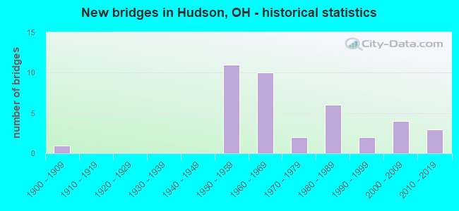
- New bridges - historical statistics
- 11900-1909
- 111950-1959
- 101960-1969
- 21970-1979
- 61980-1989
- 21990-1999
- 42000-2009
- 32010-2019

- Reconstructed bridges - Historical Statistics
- 11970-1979
- 21980-1989
- 11990-1999
- 22000-2009
- 12010-2019


- Bridge Condition - Deck
- 3.7%Excellent
- 25.9%Very good
- 40.7%Good
- 11.1%Satisfactory
- 14.8%Fair
- 3.7%Poor

- Bridge Condition - Superstructure
- 7.4%Excellent
- 29.6%Very good
- 33.3%Good
- 18.5%Satisfactory
- 7.4%Fair
- 3.7%Poor

- Bridge Condition - Substructure
- 7.4%Excellent
- 22.2%Very good
- 55.6%Good
- 3.7%Satisfactory
- 7.4%Fair
- 3.7%Poor

- Bridge Condition - Channel
- 9.5%Excellent
- 33.3%Very good
- 14.3%Good
- 38.1%Satisfactory
- 4.8%Fair

- Bridge Condition - Culverts
- 50.0%Very good
- 25.0%Good
- 25.0%Satisfactory
Find on map >> Show street view
Structure Number: 7700164, Location: 0.86 MI S OF SR 303 (Lat: 41.219889, Lng: -81.489069), Route carried "on" structure: State highway 8, Year Built: 1987, Status: Open, Structure Length: 3.69m (12.11ft), Average Daily Traffic: 23,279 (year 2015), Truck Traffic: 7%, Average Future Daily Traffic: 32,311 (year 2035), Design Load: HS 20+Mod, Features Intersected: OVER REL BARLOW RD CR-12
Minimum Vertical Clearance: 30+ m (98+ ft), Kilometerpoint: 19.087, Lanes on structure: 6, Lanes under structure: 2, Base Highway Network: Yes, Owner: State Highway Agency, Approaching Roadway Width: 33.2m (108.9ft), Skew: 30 degrees, Material/Design: Steel continuous, Design/Construction: Stringer/Multi-beam, Number Of Spans In Main Unit: 3, Length of Maximum Span: 14.9m (48.9ft), Curb-To-Curb Width: 32.5m (106.6ft), Out-to-Out Width: 33.5m (109.9ft)
Condition: Deck: Good, Superstructure: Very good, Substructure: Good, Operating Rating: 42.1 metric tons, Method Used To Determine Operating Rating: Load Factor (LF) rating reported by rating factor (RF) method using MS18 loading, Inventory Rating: 32.4 metric tons, Method Used To Determine Inventory Rating: Load Factor (LF) rating reported by rating factor (RF) method using MS18 loading, Structural Evaluation: Better than present minimum criteria, Deck Geometry: Superior to present desirable criteria, Underclear: Equal to present minimum criteria, Approach Roadway Alignment: Equal to present desirable criteria, Designated Inspection Frequency: Every 24 months, Inspection Date: November 2021, Deck Structure Type: Concrete Cast-file-Place, Wearing Surface/Protective System: Wearing Surface: Integral Concrete, Deck Protection: Epoxy Coated Reinforcing
Find on map >> Show street view
Structure Number: 7710445, Location: 2.63 MI E OF SR 91 (Lat: 41.277089, Lng: -81.409811), Route carried "on" structure: Interstate 480, Year Built: 1965, Status: Open, Structure Length: 3.63m (11.91ft), Average Daily Traffic: 18,425 (year 2015), Truck Traffic: 12%, Average Future Daily Traffic: 25,574 (year 2035), Design Load: HS 20+Mod, Features Intersected: OVER STOW RD CR-106
Minimum Vertical Clearance: 30+ m (98+ ft), Kilometerpoint: 11.990, Lanes on structure: 2, Lanes under structure: 2, Base Highway Network: Yes, Owner: State Highway Agency, Approaching Roadway Width: 7.3m (24.0ft), Material/Design: Concrete continuous, Design/Construction: Slab, Number Of Spans In Main Unit: 3, Length of Maximum Span: 15.2m (49.9ft), Curb-To-Curb Width: 9.1m (29.9ft), Out-to-Out Width: 11.0m (36.1ft)
Condition: Deck: Fair, Superstructure: Satisfactory, Substructure: Good, Operating Rating: 42.1 metric tons, Method Used To Determine Operating Rating: Allowable Stress (AS) rating reported by rating factor (RF) method using MS18 loading, Inventory Rating: 32.4 metric tons, Method Used To Determine Inventory Rating: Allowable Stress (AS) rating reported by rating factor (RF) method using MS18 loading, Structural Evaluation: Equal to present minimum criteria, Deck Geometry: High priority of replacement, Underclear: Equal to present minimum criteria, Approach Roadway Alignment: Equal to present desirable criteria, Designated Inspection Frequency: Every 12 months, Inspection Date: August 2021, Deck Structure Type: Concrete Cast-file-Place, Wearing Surface/Protective System: Wearing Surface: Integral Concrete
Find on map >> Show street view
Structure Number: 7710534, Location: 2.63 MI E OF SR 91 (Lat: 41.276739, Lng: -81.410019), Route carried "on" structure: Interstate 480, Year Built: 1965, Status: Open, Structure Length: 3.63m (11.91ft), Average Daily Traffic: 18,425 (year 2015), Truck Traffic: 12%, Average Future Daily Traffic: 25,574 (year 2035), Design Load: HS 20+Mod, Features Intersected: OVER STOW RD CR-106
Minimum Vertical Clearance: 30+ m (98+ ft), Kilometerpoint: 11.990, Lanes on structure: 2, Lanes under structure: 2, Base Highway Network: Yes, Owner: State Highway Agency, Approaching Roadway Width: 7.3m (24.0ft), Material/Design: Concrete continuous, Design/Construction: Slab, Number Of Spans In Main Unit: 3, Length of Maximum Span: 15.2m (49.9ft), Curb-To-Curb Width: 9.1m (29.9ft), Out-to-Out Width: 11.0m (36.1ft)
Condition: Deck: Fair, Superstructure: Satisfactory, Substructure: Good, Operating Rating: 42.1 metric tons, Method Used To Determine Operating Rating: Allowable Stress (AS) rating reported by rating factor (RF) method using MS18 loading, Inventory Rating: 32.4 metric tons, Method Used To Determine Inventory Rating: Allowable Stress (AS) rating reported by rating factor (RF) method using MS18 loading, Structural Evaluation: Equal to present minimum criteria, Deck Geometry: High priority of replacement, Underclear: Equal to present minimum criteria, Approach Roadway Alignment: Equal to present desirable criteria, Designated Inspection Frequency: Every 12 months, Inspection Date: August 2021, Deck Structure Type: Concrete Cast-file-Place, Wearing Surface/Protective System: Wearing Surface: Integral Concrete
Find on map >> Show street view
Structure Number: 7710569, Location: 3.33 MI E OF SR 91 (Lat: 41.269661, Lng: -81.400731), Route carried "on" structure: County highway C0132, Year Built: 1965, Status: Open, Structure Length: 11.67m (38.29ft), Average Daily Traffic: 1,692 (year 2015), Truck Traffic: 2%, Average Future Daily Traffic: 51,148 (year 2035), Design Load: H 15, Features Intersected: I-480, Facility Carried by Structure: MIDDLETOWN RD # 13
Minimum Vertical Clearance: 30+ m (98+ ft), Kilometerpoint: 5.343, Lanes on structure: 2, Lanes under structure: 4, Owner: State Highway Agency, Approaching Roadway Width: 6.1m (20.0ft), Skew: 4 degrees, Material/Design: Steel continuous, Design/Construction: Stringer/Multi-beam, Number Of Spans In Main Unit: 4, Length of Maximum Span: 33.5m (109.9ft), Curb or Sidewalk Widths: Left: 0.7m (2.3ft), Right: 0.7m (2.3ft), Curb-To-Curb Width: 7.3m (24.0ft), Out-to-Out Width: 9.3m (30.5ft)
Condition: Deck: Good, Superstructure: Good, Substructure: Good, Operating Rating: 32.4 metric tons, Method Used To Determine Operating Rating: Load and Resistance Factor Rating (LRFR) rating reported by rating factor(RF) method using HL-93 loadings, Inventory Rating: 25.9 metric tons, Method Used To Determine Inventory Rating: Load and Resistance Factor Rating (LRFR) rating reported by rating factor(RF) method using HL-93 loadings, Structural Evaluation: Equal to present minimum criteria, Deck Geometry: Meets minimum limits, Underclear: High priority of corrective action, Approach Roadway Alignment: Equal to present desirable criteria, Designated Inspection Frequency: Every 24 months, Inspection Date: September 2021, Deck Structure Type: Concrete Cast-file-Place, Wearing Surface/Protective System: Wearing Surface: Integral Concrete
Find on map >> Show street view
Structure Number: 7710593, Location: 3.78 MI E OF SR 91 (Lat: 41.266050, Lng: -81.393369), Route carried "on" structure: Interstate 480, Year Built: 1965, Status: Open, Structure Length: 7.47m (24.51ft), Average Daily Traffic: 18,425 (year 2015), Truck Traffic: 12%, Average Future Daily Traffic: 25,574 (year 2035), Design Load: HS 20+Mod, Features Intersected: TINKERS CREEK
Minimum Vertical Clearance: 30+ m (98+ ft), Kilometerpoint: 13.840, Lanes on structure: 2, Base Highway Network: Yes, Owner: State Highway Agency, Approaching Roadway Width: 14.0m (45.9ft), Material/Design: Steel continuous, Design/Construction: Stringer/Multi-beam, Number Of Spans In Main Unit: 3, Length of Maximum Span: 28.0m (91.9ft), Curb-To-Curb Width: 12.1m (39.7ft), Out-to-Out Width: 13.4m (44.0ft)
Condition: Deck: Good, Superstructure: Good, Substructure: Good, Channel: Very good, Operating Rating: 42.1 metric tons, Method Used To Determine Operating Rating: Allowable Stress (AS) rating reported by rating factor (RF) method using MS18 loading, Inventory Rating: 32.4 metric tons, Method Used To Determine Inventory Rating: Allowable Stress (AS) rating reported by rating factor (RF) method using MS18 loading, Structural Evaluation: Better than present minimum criteria, Deck Geometry: Equal to present minimum criteria, Waterway Adequacy: Equal to present desirable criteria, Approach Roadway Alignment: Equal to present desirable criteria, Designated Inspection Frequency: Every 24 months, Inspection Date: September 2021, Deck Structure Type: Concrete Cast-file-Place, Wearing Surface/Protective System: Wearing Surface: Integral Concrete
Find on map >> Show street view
Structure Number: 7710623, Location: 3.78 MI E OF SR 91 (Lat: 41.265831, Lng: -81.393550), Route carried "on" structure: Interstate 480, Year Built: 1965, Status: Open, Structure Length: 7.47m (24.51ft), Average Daily Traffic: 18,425 (year 2015), Truck Traffic: 12%, Average Future Daily Traffic: 25,574 (year 2035), Design Load: HS 20, Features Intersected: TINKERS CREEK
Minimum Vertical Clearance: 30+ m (98+ ft), Kilometerpoint: 13.840, Lanes on structure: 2, Base Highway Network: Yes, Owner: State Highway Agency, Approaching Roadway Width: 14.0m (45.9ft), Material/Design: Steel continuous, Design/Construction: Stringer/Multi-beam, Number Of Spans In Main Unit: 3, Length of Maximum Span: 28.0m (91.9ft), Curb-To-Curb Width: 12.1m (39.7ft), Out-to-Out Width: 13.4m (44.0ft)
Condition: Deck: Good, Superstructure: Good, Substructure: Good, Channel: Very good, Operating Rating: 42.1 metric tons, Method Used To Determine Operating Rating: Allowable Stress (AS) rating reported by rating factor (RF) method using MS18 loading, Inventory Rating: 32.4 metric tons, Method Used To Determine Inventory Rating: Allowable Stress (AS) rating reported by rating factor (RF) method using MS18 loading, Structural Evaluation: Better than present minimum criteria, Deck Geometry: Equal to present minimum criteria, Waterway Adequacy: Equal to present desirable criteria, Approach Roadway Alignment: Equal to present desirable criteria, Designated Inspection Frequency: Every 24 months, Inspection Date: September 2021, Deck Structure Type: Concrete Cast-file-Place, Wearing Surface/Protective System: Wearing Surface: Integral Concrete
Find on map >> Show street view
Structure Number: 7729782, Location: 1.2MI EAST OF EXIT 12 (Lat: 41.255331, Lng: -81.472300), Route carried "on" structure: Interstate 80K, Year Built: 1954, Status: Open, Structure Length: 0.98m (3.22ft), Average Daily Traffic: 34,729 (year 2015), Truck Traffic: 14%, Average Future Daily Traffic: 48,204 (year 2035), Design Load: H 20, Features Intersected: BRANDYWINE CREEK, Facility Carried by Structure: I80 TPK
Minimum Vertical Clearance: 30+ m (98+ ft), Kilometerpoint: 15.176, Lanes on structure: 6, Base Highway Network: Yes, Toll: On toll road, Owner: State Toll Authority, Approaching Roadway Width: 37.8m (124.0ft), Skew: 2 degrees, Material/Design: Concrete, Design/Construction: Culvert, Number Of Spans In Main Unit: 2, Length of Maximum Span: 4.3m (14.1ft)
Condition: Channel: Good, Culverts: Satisfactory, Operating Rating: 55.1 metric tons, Method Used To Determine Operating Rating: Load Factor (LF) rating reported by rating factor (RF) method using MS18 loading, Inventory Rating: 35.6 metric tons, Method Used To Determine Inventory Rating: Load Factor (LF) rating reported by rating factor (RF) method using MS18 loading, Structural Evaluation: Equal to present minimum criteria, Waterway Adequacy: Meets minimum limits, Approach Roadway Alignment: Equal to present minimum criteria, Designated Inspection Frequency: Every 12 months, Inspection Date: May 2021
Find on map >> Show street view
Structure Number: 772982, Location: 1.8MI EAST OF EXIT 12 (Lat: 41.254761, Lng: -81.461250), Route carried "on" structure: City street M2656, Year Built: 1954, Year Reconstructed: 1993, Status: Open, Structure Length: 6.80m (22.31ft), Average Daily Traffic: 1,295 (year 2015), Truck Traffic: 5%, Average Future Daily Traffic: 48,204 (year 2035), Design Load: HS 20+Mod, Features Intersected: I80 OHIO TPK, Facility Carried by Structure: PROSPECT RD
Minimum Vertical Clearance: 30+ m (98+ ft), Kilometerpoint: 0.917, Lanes on structure: 2, Lanes under structure: 6, Owner: State Toll Authority, Approaching Roadway Width: 7.9m (25.9ft), Skew: 1 degrees, Material/Design: Steel continuous, Design/Construction: Stringer/Multi-beam, Number Of Spans In Main Unit: 4, Length of Maximum Span: 21.0m (68.9ft), Curb-To-Curb Width: 8.0m (26.2ft), Out-to-Out Width: 9.1m (29.9ft)
Condition: Deck: Good, Superstructure: Good, Substructure: Good, Operating Rating: 90.7 metric tons, Method Used To Determine Operating Rating: Load Factor (LF) rating reported by rating factor (RF) method using MS18 loading, Inventory Rating: 45.4 metric tons, Method Used To Determine Inventory Rating: Load Factor (LF) rating reported by rating factor (RF) method using MS18 loading, Structural Evaluation: Better than present minimum criteria, Deck Geometry: Meets minimum limits, Underclear: High priority of corrective action, Approach Roadway Alignment: Equal to present desirable criteria, Designated Inspection Frequency: Every 24 months, Inspection Date: May 2021, Deck Structure Type: Concrete Cast-file-Place, Wearing Surface/Protective System: Wearing Surface: Monolithic Concrete
Find on map >> Show street view
Structure Number: 7729863, Location: 2.9MI EAST OF EXIT 12 (Lat: 41.254350, Lng: -81.440439), Route carried "on" structure: State highway 91, Year Built: 1954, Year Reconstructed: 1983, Status: Open, Structure Length: 6.22m (20.41ft), Average Daily Traffic: 12,960 (year 2015), Truck Traffic: 7%, Average Future Daily Traffic: 48,204 (year 2035), Design Load: HS 20+Mod, Features Intersected: I80 OHIO TPK
Minimum Vertical Clearance: 7.62m (25.00ft), Kilometerpoint: 25.170, Lanes on structure: 2, Lanes under structure: 6, Base Highway Network: Yes, Owner: State Toll Authority, Approaching Roadway Width: 7.3m (24.0ft), Material/Design: Steel continuous, Design/Construction: Stringer/Multi-beam, Number Of Spans In Main Unit: 4, Length of Maximum Span: 20.1m (65.9ft), Curb-To-Curb Width: 19.0m (62.3ft), Out-to-Out Width: 19.9m (65.3ft)
Condition: Deck: Satisfactory, Superstructure: Good, Substructure: Good, Operating Rating: 58.3 metric tons, Method Used To Determine Operating Rating: Allowable Stress (AS) rating reported by rating factor (RF) method using MS18 loading, Inventory Rating: 35.6 metric tons, Method Used To Determine Inventory Rating: Allowable Stress (AS) rating reported by rating factor (RF) method using MS18 loading, Structural Evaluation: Better than present minimum criteria, Deck Geometry: Superior to present desirable criteria, Underclear: High priority of corrective action, Approach Roadway Alignment: Equal to present desirable criteria, Designated Inspection Frequency: Every 12 months, Inspection Date: June 2021, Deck Structure Type: Concrete Cast-file-Place, Wearing Surface/Protective System: Wearing Surface: Monolithic Concrete, Deck Protection: Epoxy Coated Reinforcing
Find on map >> Show street view
Structure Number: 7729898, Location: 3.9MIEAST OF EXIT 12 (Lat: 41.253350, Lng: -81.421631), Route carried "on" structure: Interstate 80K, Year Built: 1954, Year Reconstructed: 2011, Status: Open, Structure Length: 3.93m (12.89ft), Average Daily Traffic: 34,729 (year 2015), Truck Traffic: 14%, Average Future Daily Traffic: 48,204 (year 2035), Design Load: HS 20, Features Intersected: HUDSON-AURORA RD, Facility Carried by Structure: I80 OH TPK
Minimum Vertical Clearance: 30+ m (98+ ft), Kilometerpoint: 19.409, Lanes on structure: 6, Lanes under structure: 2, Base Highway Network: Yes, Toll: On toll road, Owner: State Toll Authority, Approaching Roadway Width: 36.6m (120.1ft), Skew: 33 degrees, Material/Design: Steel continuous, Design/Construction: Stringer/Multi-beam, Number Of Spans In Main Unit: 3, Length of Maximum Span: 15.5m (50.9ft), Curb-To-Curb Width: 37.5m (123.0ft), Out-to-Out Width: 38.4m (126.0ft)
Condition: Deck: Good, Superstructure: Satisfactory, Substructure: Good, Operating Rating: 74.5 metric tons, Method Used To Determine Operating Rating: Load Factor (LF) rating reported by rating factor (RF) method using MS18 loading, Inventory Rating: 42.1 metric tons, Method Used To Determine Inventory Rating: Load Factor (LF) rating reported by rating factor (RF) method using MS18 loading, Structural Evaluation: Equal to present minimum criteria, Deck Geometry: Superior to present desirable criteria, Underclear: High priority of corrective action, Approach Roadway Alignment: Equal to present desirable criteria, Designated Inspection Frequency: Every 12 months, Inspection Date: May 2021, Deck Structure Type: Concrete Cast-file-Place, Wearing Surface/Protective System: Wearing Surface: Monolithic Concrete, Deck Protection: Epoxy Coated Reinforcing
Find on map >> Show street view
Structure Number: 7729936, Location: 2.5MI WEST OF EXIT 13 (Lat: 41.252581, Lng: -81.411081), Route carried "on" structure: County highway C0106, Year Built: 1954, Year Reconstructed: 1989, Status: Open, Structure Length: 6.19m (20.31ft), Average Daily Traffic: 10,484 (year 2015), Truck Traffic: 5%, Average Future Daily Traffic: 48,204 (year 2035), Design Load: HS 20+Mod, Features Intersected: I80 OHIO TPK, Facility Carried by Structure: STOW RD
Minimum Vertical Clearance: 30+ m (98+ ft), Kilometerpoint: 10.139, Lanes on structure: 2, Lanes under structure: 6, Owner: State Toll Authority, Approaching Roadway Width: 9.1m (29.9ft), Material/Design: Steel continuous, Design/Construction: Stringer/Multi-beam, Number Of Spans In Main Unit: 4, Length of Maximum Span: 20.1m (65.9ft), Curb or Sidewalk Widths: Left: 1.5m (4.9ft), Right: 0.0m, Curb-To-Curb Width: 9.1m (29.9ft), Out-to-Out Width: 11.6m (38.1ft)
Condition: Deck: Good, Superstructure: Good, Substructure: Good, Operating Rating: 58.3 metric tons, Method Used To Determine Operating Rating: Load Factor (LF) rating reported by rating factor (RF) method using MS18 loading, Inventory Rating: 35.6 metric tons, Method Used To Determine Inventory Rating: Load Factor (LF) rating reported by rating factor (RF) method using MS18 loading, Structural Evaluation: Better than present minimum criteria, Deck Geometry: Meets minimum limits, Underclear: High priority of corrective action, Approach Roadway Alignment: Equal to present desirable criteria, Designated Inspection Frequency: Every 24 months, Inspection Date: May 2021, Deck Structure Type: Concrete Cast-file-Place, Wearing Surface/Protective System: Wearing Surface: Monolithic Concrete, Deck Protection: Epoxy Coated Reinforcing
Find on map >> Show street view
Structure Number: 7729979, Location: 1.6MI WEST OF EXIT 187 (Lat: 41.254089, Lng: -81.395381), Route carried "on" structure: Interstate 80K, Year Built: 1954, Year Reconstructed: 1997, Status: Open, Structure Length: 30.11m (98.79ft), Average Daily Traffic: 34,729 (year 2015), Truck Traffic: 14%, Average Future Daily Traffic: 48,204 (year 2035), Design Load: HS 20+Mod, Features Intersected: TINKERS CR & SWAMP, Facility Carried by Structure: I80 OH TPK
Minimum Vertical Clearance: 30+ m (98+ ft), Kilometerpoint: 21.662, Lanes on structure: 6, Base Highway Network: Yes, Toll: On toll road, Owner: State Toll Authority, Approaching Roadway Width: 36.3m (119.1ft), Skew: 30 degrees, Material/Design: Steel continuous, Design/Construction: Stringer/Multi-beam, Number Of Spans In Main Unit: 25, Length of Maximum Span: 11.9m (39.0ft), Curb-To-Curb Width: 37.3m (122.4ft), Out-to-Out Width: 38.2m (125.3ft)
Condition: Deck: Satisfactory, Superstructure: Satisfactory, Substructure: Fair, Channel: Satisfactory, Operating Rating: 68.0 metric tons, Method Used To Determine Operating Rating: Load Factor (LF) rating reported by rating factor (RF) method using MS18 loading, Inventory Rating: 38.9 metric tons, Method Used To Determine Inventory Rating: Load Factor (LF) rating reported by rating factor (RF) method using MS18 loading, Structural Evaluation: Somewhat better than minimum adequacy, Deck Geometry: Superior to present desirable criteria, Waterway Adequacy: Equal to present desirable criteria, Approach Roadway Alignment: Equal to present desirable criteria, Designated Inspection Frequency: Every 12 months, Inspection Date: May 2021, Deck Structure Type: Concrete Cast-file-Place, Wearing Surface/Protective System: Wearing Surface: Monolithic Concrete, Deck Protection: Epoxy Coated Reinforcing
Find on map >> Show street view
Structure Number: 774005, Location: 4700 FT E OF STOW RD (Lat: 41.261900, Lng: -81.394311), Route carried "on" structure: County highway C0039, Year Built: 1965, Status: Open, Structure Length: 2.44m (8.01ft), Average Daily Traffic: 4,730 (year 2018), Truck Traffic: 5%, Average Future Daily Traffic: 6,565 (year 2038), Design Load: H 20, Features Intersected: TINKERS CREEK, Facility Carried by Structure: HUDSON-AURORA RD
Minimum Vertical Clearance: 30+ m (98+ ft), Kilometerpoint: 4.764, Lanes on structure: 2, Owner: County Highway Agency, Approaching Roadway Width: 9.8m (32.2ft), Skew: 1 degrees, Material/Design: Concrete continuous, Design/Construction: Slab, Number Of Spans In Main Unit: 3, Length of Maximum Span: 9.1m (29.9ft), Curb-To-Curb Width: 10.6m (34.8ft), Out-to-Out Width: 11.0m (36.1ft)
Condition: Deck: Good, Superstructure: Good, Substructure: Good, Channel: Good, Operating Rating: 55.1 metric tons, Method Used To Determine Operating Rating: Load Factor (LF) rating reported by rating factor (RF) method using MS18 loading, Inventory Rating: 32.4 metric tons, Method Used To Determine Inventory Rating: Load Factor (LF) rating reported by rating factor (RF) method using MS18 loading, Structural Evaluation: Better than present minimum criteria, Deck Geometry: Somewhat better than minimum adequacy, Waterway Adequacy: Better than present minimum criteria, Approach Roadway Alignment: Equal to present desirable criteria, Designated Inspection Frequency: Every 24 months, Inspection Date: April 2021, Deck Structure Type: Concrete Cast-file-Place, Wearing Surface/Protective System: Wearing Surface: Epoxy Overlay
Find on map >> Show street view
Structure Number: 7740085, Location: 100 FT W WALTERS RD (Lat: 41.260281, Lng: -81.489189), Route carried "on" structure: County highway C0115, Year Built: 1950, Status: Open, Structure Length: 0.98m (3.22ft), Average Daily Traffic: 6,920 (year 2018), Truck Traffic: 1%, Average Future Daily Traffic: 9,605 (year 2038), Design Load: H 15, Features Intersected: BRANDYWINE CREEK, Facility Carried by Structure: E. HINES HILL RD
Minimum Vertical Clearance: 30+ m (98+ ft), Kilometerpoint: 6.582, Lanes on structure: 2, Owner: County Highway Agency, Approaching Roadway Width: 7.9m (25.9ft), Skew: 2 degrees, Material/Design: Concrete, Design/Construction: Slab, Number Of Spans In Main Unit: 1, Length of Maximum Span: 9.5m (31.2ft), Curb-To-Curb Width: 9.3m (30.5ft), Out-to-Out Width: 9.9m (32.5ft)
Condition: Deck: Fair, Superstructure: Fair, Substructure: Fair, Channel: Satisfactory, Operating Rating: 42.1 metric tons, Method Used To Determine Operating Rating: Load Factor (LF) rating reported by rating factor (RF) method using MS18 loading, Inventory Rating: 25.9 metric tons, Method Used To Determine Inventory Rating: Load Factor (LF) rating reported by rating factor (RF) method using MS18 loading, Structural Evaluation: Somewhat better than minimum adequacy, Deck Geometry: High priority of corrective action, Waterway Adequacy: Better than present minimum criteria, Approach Roadway Alignment: Equal to present desirable criteria, Designated Inspection Frequency: Every 12 months, Inspection Date: April 2021, Deck Structure Type: Concrete Cast-file-Place, Wearing Surface/Protective System: Wearing Surface: Bituminous
Find on map >> Show street view
Structure Number: 7740131, Location: 2400 FT W OF HUDSON DR (Lat: 41.217739, Lng: -81.451811), Route carried "on" structure: County highway C0509, Year Built: 1966, Status: Open, Structure Length: 4.21m (13.81ft), Average Daily Traffic: 7,483 (year 2018), Truck Traffic: 7%, Average Future Daily Traffic: 10,386 (year 2038), Design Load: HS 20+Mod, Features Intersected: NORFOLK SOUTHERN RW, Facility Carried by Structure: TEREX RD
Minimum Vertical Clearance: 30+ m (98+ ft), Kilometerpoint: 3.798, Lanes on structure: 2, Owner: County Highway Agency, Approaching Roadway Width: 12.2m (40.0ft), Skew: 1 degrees, Material/Design: Concrete continuous, Design/Construction: Slab, Number Of Spans In Main Unit: 3, Length of Maximum Span: 15.9m (52.2ft), Curb-To-Curb Width: 12.8m (42.0ft), Out-to-Out Width: 14.1m (46.3ft)
Condition: Deck: Very good, Superstructure: Very good, Substructure: Very good, Operating Rating: 64.8 metric tons, Method Used To Determine Operating Rating: Load Factor (LF) rating reported by rating factor (RF) method using MS18 loading, Inventory Rating: 38.9 metric tons, Method Used To Determine Inventory Rating: Load Factor (LF) rating reported by rating factor (RF) method using MS18 loading, Structural Evaluation: Equal to present desirable criteria, Deck Geometry: Somewhat better than minimum adequacy, Underclear: Superior to present desirable criteria, Approach Roadway Alignment: Equal to present desirable criteria, Designated Inspection Frequency: Every 24 months, Inspection Date: April 2021, Deck Structure Type: Concrete Cast-file-Place, Wearing Surface/Protective System: Wearing Surface: Bituminous
Find on map >> Show street view
Structure Number: 774022, Location: 500 FT S OF HUDSON-AURORA (Lat: 41.259931, Lng: -81.407069), Route carried "on" structure: City street 2903, Year Built: 1977, Status: Open, Structure Length: 0.78m (2.56ft), Average Daily Traffic: 150 (year 1988), Truck Traffic: 1%, Average Future Daily Traffic: 208 (year 2008), Design Load: HS 20+Mod, Features Intersected: WAGAR DITCH, Facility Carried by Structure: DILLMAN DR
Minimum Vertical Clearance: 30+ m (98+ ft), Kilometerpoint: 0.177, Lanes on structure: 2, Owner: City or Municipal Highway Agency, Approaching Roadway Width: 7.9m (25.9ft), Material/Design: Prestressed concrete, Design/Construction: Box Beam or Girders - Multiple, Number Of Spans In Main Unit: 1, Length of Maximum Span: 7.4m (24.3ft), Curb-To-Curb Width: 8.5m (27.9ft), Out-to-Out Width: 8.5m (27.9ft)
Condition: Deck: Poor, Superstructure: Poor, Substructure: Good, Channel: Satisfactory, Operating Rating: 97.2 metric tons, Method Used To Determine Operating Rating: Load Factor (LF) rating reported by rating factor (RF) method using MS18 loading, Inventory Rating: 61.6 metric tons, Method Used To Determine Inventory Rating: Load Factor (LF) rating reported by rating factor (RF) method using MS18 loading, Structural Evaluation: Meets minimum limits, Deck Geometry: Equal to present minimum criteria, Waterway Adequacy: Better than present minimum criteria, Approach Roadway Alignment: Equal to present minimum criteria, Designated Inspection Frequency: Every 12 months, Inspection Date: April 2021, Deck Structure Type: Other, Wearing Surface/Protective System: Wearing Surface: Integral Concrete
Find on map >> Show street view
Structure Number: 7740263, Location: 700 FT S OF HUDSON-AURORA (Lat: 41.259669, Lng: -81.404111), Route carried "on" structure: City street 1553, Year Built: 1990, Status: Open, Structure Length: 0.79m (2.59ft), Average Daily Traffic: 600 (year 1988), Truck Traffic: 1%, Average Future Daily Traffic: 833 (year 2008), Design Load: HS 20, Features Intersected: BR. TINKERS CK, Facility Carried by Structure: HUNTINGTON DR
Minimum Vertical Clearance: 30+ m (98+ ft), Kilometerpoint: 0.772, Lanes on structure: 2, Owner: City or Municipal Highway Agency, Approaching Roadway Width: 8.8m (28.9ft), Skew: 2 degrees, Material/Design: Concrete, Design/Construction: Frame, Number Of Spans In Main Unit: 1, Length of Maximum Span: 7.3m (24.0ft), Curb-To-Curb Width: 10.3m (33.8ft), Out-to-Out Width: 10.7m (35.1ft)
Condition: Deck: Good, Superstructure: Good, Substructure: Good, Channel: Fair, Operating Rating: 55.1 metric tons, Method Used To Determine Operating Rating: Load Factor (LF) rating reported by rating factor (RF) method using MS18 loading, Inventory Rating: 32.4 metric tons, Method Used To Determine Inventory Rating: Load Factor (LF) rating reported by rating factor (RF) method using MS18 loading, Structural Evaluation: Better than present minimum criteria, Deck Geometry: Equal to present minimum criteria, Waterway Adequacy: Equal to present desirable criteria, Approach Roadway Alignment: Equal to present desirable criteria, Designated Inspection Frequency: Every 24 months, Inspection Date: April 2021, Deck Structure Type: Concrete Cast-file-Place, Wearing Surface/Protective System: Wearing Surface: Bituminous, Deck Protection: Epoxy Coated Reinforcing
Find on map >> Show street view
Structure Number: 7740298, Location: INTER HUDSON-AURORA&STOW (Lat: 41.261669, Lng: -81.411669), Route carried "on" structure: County highway C0106, Year Built: 1993, Status: Open, Structure Length: 0.79m (2.59ft), Average Daily Traffic: 16,246 (year 2018), Truck Traffic: 5%, Average Future Daily Traffic: 22,549 (year 2038), Design Load: HS 20+Mod, Features Intersected: WAGAR DITCH, Facility Carried by Structure: HUDSON-AURORA&STOW
Minimum Vertical Clearance: 30+ m (98+ ft), Kilometerpoint: 11.056, Lanes on structure: 2, Owner: County Highway Agency, Approaching Roadway Width: 8.5m (27.9ft), Skew: 3 degrees, Material/Design: Concrete, Design/Construction: Culvert, Number Of Spans In Main Unit: 1, Length of Maximum Span: 7.3m (24.0ft)
Condition: Channel: Satisfactory, Culverts: Good, Operating Rating: 58.3 metric tons, Method Used To Determine Operating Rating: Load Factor (LF) rating reported by rating factor (RF) method using MS18 loading, Inventory Rating: 35.6 metric tons, Method Used To Determine Inventory Rating: Load Factor (LF) rating reported by rating factor (RF) method using MS18 loading, Structural Evaluation: Better than present minimum criteria, Waterway Adequacy: Equal to present desirable criteria, Approach Roadway Alignment: Equal to present desirable criteria, Designated Inspection Frequency: Every 24 months, Inspection Date: April 2021
Find on map >> Show street view
Structure Number: 7740301, Location: 400 FT W OF HUDSON ROAD (Lat: 41.202950, Lng: -81.456039), Route carried "on" structure: County highway 145, Year Built: 2003, Status: Open, Structure Length: 1.34m (4.40ft), Average Daily Traffic: 3,113 (year 2018), Truck Traffic: 7%, Average Future Daily Traffic: 4,321 (year 2038), Design Load: HS 20+Mod, Features Intersected: POWERS BROOK, Facility Carried by Structure: SEASONS ROAD
Minimum Vertical Clearance: 30+ m (98+ ft), Kilometerpoint: 3.347, Lanes on structure: 2, Owner: County Highway Agency, Approaching Roadway Width: 9.8m (32.2ft), Material/Design: Concrete, Design/Construction: Culvert, Number Of Spans In Main Unit: 1, Length of Maximum Span: 12.8m (42.0ft)
Condition: Channel: Satisfactory, Culverts: Very good, Operating Rating: 61.6 metric tons, Method Used To Determine Operating Rating: Allowable Stress (AS) rating reported by rating factor (RF) method using MS18 loading, Inventory Rating: 38.9 metric tons, Method Used To Determine Inventory Rating: Allowable Stress (AS) rating reported by rating factor (RF) method using MS18 loading, Structural Evaluation: Equal to present desirable criteria, Waterway Adequacy: Equal to present desirable criteria, Approach Roadway Alignment: Equal to present desirable criteria, Designated Inspection Frequency: Every 24 months, Inspection Date: March 2021
Find on map >> Show street view
Structure Number: 7740328, Location: 200 FT W OF ALLEN RD (Lat: 41.203331, Lng: -81.473331), Route carried "on" structure: County highway 145, Year Built: 2010, Status: Open, Structure Length: 1.46m (4.79ft), Average Daily Traffic: 3,020 (year 2018), Truck Traffic: 7%, Average Future Daily Traffic: 4,192 (year 2038), Design Load: HS 25 or greater, Features Intersected: MUD BROOK, Facility Carried by Structure: SEASONS RD
Minimum Vertical Clearance: 30+ m (98+ ft), Kilometerpoint: 1.931, Lanes on structure: 2, Owner: County Highway Agency, Approaching Roadway Width: 7.9m (25.9ft), Material/Design: Concrete, Design/Construction: Culvert, Number Of Spans In Main Unit: 1, Length of Maximum Span: 14.6m (47.9ft)
Condition: Channel: Very good, Culverts: Very good, Operating Rating: 64.8 metric tons, Method Used To Determine Operating Rating: Load Factor (LF) rating reported by rating factor (RF) method using MS18 loading, Inventory Rating: 38.9 metric tons, Method Used To Determine Inventory Rating: Load Factor (LF) rating reported by rating factor (RF) method using MS18 loading, Structural Evaluation: Equal to present desirable criteria, Waterway Adequacy: Better than present minimum criteria, Approach Roadway Alignment: Equal to present minimum criteria, Designated Inspection Frequency: Every 24 months, Inspection Date: March 2021
Find on map >> Show street view
Structure Number: 7740352, Location: 300 FT E OF MIDDLETON RD (Lat: 41.269311, Lng: -81.392931), Route carried "on" structure: County highway C0012, Year Built: 2015, Status: Open, Structure Length: 2.90m (9.51ft), Average Daily Traffic: 1,566 (year 2018), Truck Traffic: 5%, Average Future Daily Traffic: 2,174 (year 2038), Design Load: HL 93, Features Intersected: TINKERS CREEK, Facility Carried by Structure: RAVENNA RD - CR 12
Minimum Vertical Clearance: 30+ m (98+ ft), Kilometerpoint: 0.080, Lanes on structure: 2, Owner: County Highway Agency, Approaching Roadway Width: 7.3m (24.0ft), Material/Design: Prestressed concrete, Design/Construction: Stringer/Multi-beam, Number Of Spans In Main Unit: 1, Length of Maximum Span: 28.3m (92.8ft), Curb-To-Curb Width: 12.2m (40.0ft), Out-to-Out Width: 12.2m (40.0ft)
Condition: Deck: Very good, Superstructure: Excellent, Substructure: Excellent, Channel: Excellent, Operating Rating: 61.6 metric tons, Method Used To Determine Operating Rating: Load and Resistance Factor Rating (LRFR) rating reported by rating factor(RF) method using HL-93 loadings, Inventory Rating: 45.4 metric tons, Method Used To Determine Inventory Rating: Load and Resistance Factor Rating (LRFR) rating reported by rating factor(RF) method using HL-93 loadings, Structural Evaluation: Superior to present desirable criteria, Deck Geometry: Better than present minimum criteria, Waterway Adequacy: Better than present minimum criteria, Approach Roadway Alignment: Equal to present desirable criteria, Length Of Structure Improvement: 2.90m (9.51ft), Designated Inspection Frequency: Every 24 months, Inspection Date: April 2021, Roadway Improvement Cost: $1,000, Total Project Cost: $2,000, Deck Structure Type: Concrete Cast-file-Place, Wearing Surface/Protective System: Wearing Surface: Monolithic Concrete, Deck Protection: Other Coated Reinforcing
Find on map >> Show street view
Structure Number: 7741022, Location: 3200 FT W OF DARROW RD (Lat: 41.248981, Lng: -81.452011), Route carried "on" structure: City street M0142, Year Built: 1973, Year Reconstructed: 2006, Status: Open, Structure Length: 1.17m (3.84ft), Average Daily Traffic: 150 (year 1988), Truck Traffic: 1%, Average Future Daily Traffic: 208 (year 2008), Design Load: HS 20+Mod, Features Intersected: BR BRANDYWINE CREEK, Facility Carried by Structure: W PROSPECT ST
Minimum Vertical Clearance: 30+ m (98+ ft), Kilometerpoint: 1.770, Lanes on structure: 2, Owner: City or Municipal Highway Agency, Approaching Roadway Width: 6.7m (22.0ft), Material/Design: Steel, Design/Construction: Stringer/Multi-beam, Number Of Spans In Main Unit: 1, Length of Maximum Span: 11.1m (36.4ft), Curb-To-Curb Width: 7.3m (24.0ft), Out-to-Out Width: 7.3m (24.0ft)
Condition: Deck: Satisfactory, Superstructure: Satisfactory, Substructure: Satisfactory, Channel: Satisfactory, Operating Rating: 58.3 metric tons, Method Used To Determine Operating Rating: Load Factor (LF) rating reported by rating factor (RF) method using MS18 loading, Inventory Rating: 35.6 metric tons, Method Used To Determine Inventory Rating: Load Factor (LF) rating reported by rating factor (RF) method using MS18 loading, Structural Evaluation: Equal to present minimum criteria, Deck Geometry: Somewhat better than minimum adequacy, Waterway Adequacy: Better than present minimum criteria, Approach Roadway Alignment: Equal to present desirable criteria, Designated Inspection Frequency: Every 12 months, Inspection Date: April 2021, Deck Structure Type: Corrugated Steel, Wearing Surface/Protective System: Wearing Surface: Bituminous
Find on map >> Show street view
Structure Number: 774103, Location: 500 FT W OF ATTERBURY BLV (Lat: 41.246100, Lng: -81.470431), Route carried "on" structure: County highway C0032, Year Built: 1985, Status: Open, Structure Length: 2.07m (6.79ft), Average Daily Traffic: 5,568 (year 2015), Truck Traffic: 5%, Average Future Daily Traffic: 7,728 (year 2035), Design Load: HS 20+Mod, Features Intersected: BRANDYWINE CREEK, Facility Carried by Structure: D BOSTON MILLS RD
Minimum Vertical Clearance: 30+ m (98+ ft), Kilometerpoint: 14.645, Lanes on structure: 2, Owner: County Highway Agency, Approaching Roadway Width: 8.8m (28.9ft), Material/Design: Prestressed concrete, Design/Construction: Box Beam or Girders - Multiple, Number Of Spans In Main Unit: 1, Length of Maximum Span: 20.1m (65.9ft), Curb-To-Curb Width: 10.4m (34.1ft), Out-to-Out Width: 10.7m (35.1ft)
Condition: Deck: Good, Superstructure: Very good, Substructure: Very good, Channel: Very good, Operating Rating: 51.8 metric tons, Method Used To Determine Operating Rating: Load Factor (LF) rating reported by rating factor (RF) method using MS18 loading, Inventory Rating: 32.4 metric tons, Method Used To Determine Inventory Rating: Load Factor (LF) rating reported by rating factor (RF) method using MS18 loading, Structural Evaluation: Equal to present desirable criteria, Deck Geometry: Meets minimum limits, Waterway Adequacy: Equal to present desirable criteria, Approach Roadway Alignment: Superior to present desirable criteria, Designated Inspection Frequency: Every 24 months, Inspection Date: June 2021, Deck Structure Type: Other, Wearing Surface/Protective System: Wearing Surface: Bituminous
Find on map >> Show street view
Structure Number: 7741049, Location: 100 FT E OF ATTERBURY BLV (Lat: 41.245650, Lng: -81.468331), Route carried "on" structure: County highway C0032, Year Built: 1989, Status: Open, Structure Length: 0.82m (2.69ft), Average Daily Traffic: 5,568 (year 2015), Truck Traffic: 5%, Average Future Daily Traffic: 7,728 (year 2035), Design Load: HS 20, Features Intersected: BRANDYWINE CREEK, Facility Carried by Structure: D BOSTON MILLS RD
Minimum Vertical Clearance: 30+ m (98+ ft), Kilometerpoint: 14.822, Lanes on structure: 2, Owner: County Highway Agency, Approaching Roadway Width: 8.8m (28.9ft), Skew: 3 degrees, Material/Design: Concrete, Design/Construction: Frame, Number Of Spans In Main Unit: 1, Length of Maximum Span: 7.6m (24.9ft), Curb-To-Curb Width: 10.4m (34.1ft), Out-to-Out Width: 10.4m (34.1ft)
Condition: Deck: Good, Superstructure: Good, Substructure: Good, Channel: Very good, Operating Rating: 81.0 metric tons, Method Used To Determine Operating Rating: Load Factor (LF) rating reported by rating factor (RF) method using MS18 loading, Inventory Rating: 48.6 metric tons, Method Used To Determine Inventory Rating: Load Factor (LF) rating reported by rating factor (RF) method using MS18 loading, Structural Evaluation: Better than present minimum criteria, Deck Geometry: Meets minimum limits, Waterway Adequacy: Equal to present desirable criteria, Approach Roadway Alignment: Equal to present desirable criteria, Designated Inspection Frequency: Every 24 months, Inspection Date: June 2021, Deck Structure Type: Concrete Cast-file-Place, Wearing Surface/Protective System: Wearing Surface: Bituminous, Membrane: Preformed Fabric, Deck Protection: Epoxy Coated Reinforcing
Find on map >> Show street view
Structure Number: 7756097, Location: 150 FT N of Old Mill Rd (Lat: 41.285169, Lng: -81.406100), Route carried "on" structure: County highway C0012, Year Built: 2014, Status: Open, Structure Length: 2.64m (8.66ft), Average Daily Traffic: 4,513 (year 2015), Truck Traffic: 5%, Average Future Daily Traffic: 6,264 (year 2035), Design Load: HL 93, Features Intersected: TINKERS CREEK, Facility Carried by Structure: Ravenna Road
Minimum Vertical Clearance: 30+ m (98+ ft), Kilometerpoint: 2.253, Lanes on structure: 2, Owner: County Highway Agency, Approaching Roadway Width: 7.3m (24.0ft), Skew: 2 degrees, Material/Design: Steel, Design/Construction: Stringer/Multi-beam, Number Of Spans In Main Unit: 1, Length of Maximum Span: 25.8m (84.6ft), Curb-To-Curb Width: 10.4m (34.1ft), Out-to-Out Width: 11.4m (37.4ft)
Condition: Deck: Excellent, Superstructure: Excellent, Substructure: Excellent, Channel: Excellent, Operating Rating: 58.3 metric tons, Method Used To Determine Operating Rating: Load and Resistance Factor Rating (LRFR) rating reported by rating factor(RF) method using HL-93 loadings, Inventory Rating: 45.4 metric tons, Method Used To Determine Inventory Rating: Load and Resistance Factor Rating (LRFR) rating reported by rating factor(RF) method using HL-93 loadings, Structural Evaluation: Superior to present desirable criteria, Deck Geometry: Somewhat better than minimum adequacy, Waterway Adequacy: Superior to present desirable criteria, Approach Roadway Alignment: Equal to present desirable criteria, Length Of Structure Improvement: 2.64m (8.66ft), Designated Inspection Frequency: Every 24 months, Inspection Date: January 2021, Total Project Cost: $1,843,000, Deck Structure Type: Concrete Cast-file-Place, Wearing Surface/Protective System: Wearing Surface: Monolithic Concrete, Deck Protection: Epoxy Coated Reinforcing
Find on map >> Show street view
Structure Number: 7767811, Location: 200 FT N OF BOSTON MILLS (Lat: 41.246000, Lng: -81.466500), Route carried "on" structure: City street INGLE, Year Built: 1900, Status: Posted for load, Structure Length: 0.76m (2.49ft), Average Daily Traffic: 5,568 (year 2015), Truck Traffic: 5%, Average Future Daily Traffic: 7,728 (year 2035), Design Load: HS 20, Features Intersected: BRANDYWINE CREEK
Minimum Vertical Clearance: 30+ m (98+ ft), Kilometerpoint: 0.016, Lanes on structure: 2, Owner: City or Municipal Highway Agency, Approaching Roadway Width: 6.1m (20.0ft), Material/Design: Concrete, Design/Construction: Slab, Number Of Spans In Main Unit: 1, Length of Maximum Span: 6.7m (22.0ft), Curb-To-Curb Width: 9.1m (29.9ft), Out-to-Out Width: 10.0m (32.8ft)
Condition: Deck: Fair, Superstructure: Fair, Substructure: Poor, Channel: Satisfactory, Operating Rating: 29.2 metric tons, Method Used To Determine Operating Rating: Load Factor (LF) rating reported by rating factor (RF) method using MS18 loading, Inventory Rating: 16.2 metric tons, Method Used To Determine Inventory Rating: Load Factor (LF) rating reported by rating factor (RF) method using MS18 loading, Structural Evaluation: Meets minimum limits, Deck Geometry: High priority of corrective action, Waterway Adequacy: Equal to present minimum criteria, Approach Roadway Alignment: Equal to present desirable criteria, Bridge Posting: Required (Relationship of Operating Rating to Maximum Legal Load: > 39.9% below), Designated Inspection Frequency: Every 12 months, Inspection Date: April 2021, Deck Structure Type: Concrete Cast-file-Place, Wearing Surface/Protective System: Wearing Surface: Bituminous
Find on map >> Show street view
Structure Number: 7767862, Location: 200 FT S OF BRANDYWINE DR (Lat: 41.250219, Lng: -81.449500), Route carried "on" structure: City street BLACK, Year Built: 1989, Year Reconstructed: 2016, Status: Open, Structure Length: 0.79m (2.59ft), Average Daily Traffic: 110 (year 2007), Truck Traffic: 9%, Average Future Daily Traffic: 153 (year 2027), Design Load: HS 20, Features Intersected: BRANDYWINE CREEK
Minimum Vertical Clearance: 30+ m (98+ ft), Kilometerpoint: 0.048, Lanes on structure: 2, Owner: City or Municipal Highway Agency, Approaching Roadway Width: 7.9m (25.9ft), Material/Design: Concrete, Design/Construction: Arch - Deck, Number Of Spans In Main Unit: 1, Length of Maximum Span: 7.3m (24.0ft), Curb or Sidewalk Widths: Left: 0.0m, Right: 1.5m (4.9ft), Curb-To-Curb Width: 7.9m (25.9ft), Out-to-Out Width: 7.9m (25.9ft)
Condition: Deck: Very good, Superstructure: Very good, Substructure: Very good, Channel: Very good, Operating Rating: 64.8 metric tons, Method Used To Determine Operating Rating: Load Factor (LF) rating reported by rating factor (RF) method using MS18 loading, Inventory Rating: 45.4 metric tons, Method Used To Determine Inventory Rating: Load Factor (LF) rating reported by rating factor (RF) method using MS18 loading, Structural Evaluation: Equal to present desirable criteria, Deck Geometry: Somewhat better than minimum adequacy, Waterway Adequacy: Better than present minimum criteria, Approach Roadway Alignment: Equal to present desirable criteria, Designated Inspection Frequency: Every 24 months, Inspection Date: April 2021, Deck Structure Type: Other, Wearing Surface/Protective System: Wearing Surface: Bituminous
Find on map >> Show street view
Structure Number: 776787, Location: 1400 FT W OF SR91 (Lat: 41.251969, Lng: -81.446169), Route carried "on" structure: City street BRAND, Year Built: 1989, Status: Open, Structure Length: 0.79m (2.59ft), Average Daily Traffic: 110 (year 2007), Truck Traffic: 9%, Average Future Daily Traffic: 153 (year 2027), Design Load: HS 20, Features Intersected: BRANDYWINE CREEK
Minimum Vertical Clearance: 30+ m (98+ ft), Kilometerpoint: 0.064, Lanes on structure: 2, Owner: City or Municipal Highway Agency, Approaching Roadway Width: 7.9m (25.9ft), Material/Design: Concrete, Design/Construction: Arch - Deck, Number Of Spans In Main Unit: 1, Length of Maximum Span: 7.3m (24.0ft), Curb or Sidewalk Widths: Left: 1.8m (5.9ft), Right: 1.5m (4.9ft), Curb-To-Curb Width: 8.0m (26.2ft), Out-to-Out Width: 8.0m (26.2ft)
Condition: Deck: Very good, Superstructure: Very good, Substructure: Very good, Channel: Good, Operating Rating: 64.8 metric tons, Method Used To Determine Operating Rating: Load Factor (LF) rating reported by rating factor (RF) method using MS18 loading, Inventory Rating: 45.4 metric tons, Method Used To Determine Inventory Rating: Load Factor (LF) rating reported by rating factor (RF) method using MS18 loading, Structural Evaluation: Equal to present desirable criteria, Deck Geometry: Somewhat better than minimum adequacy, Waterway Adequacy: Better than present minimum criteria, Approach Roadway Alignment: Equal to present desirable criteria, Designated Inspection Frequency: Every 24 months, Inspection Date: April 2021, Wearing Surface/Protective System: Wearing Surface: Bituminous
Find on map >> Show street view
Structure Number: 7767897, Location: 900 FT W OF SR91 (Lat: 41.242350, Lng: -81.444331), Route carried "on" structure: City street CLINT, Year Built: 2003, Status: Open, Structure Length: 0.79m (2.59ft), Average Daily Traffic: 110 (year 2007), Truck Traffic: 9%, Average Future Daily Traffic: 153 (year 2027), Design Load: HS 20, Features Intersected: BRANDYWINE CREEK
Minimum Vertical Clearance: 30+ m (98+ ft), Kilometerpoint: 0.097, Lanes on structure: 2, Owner: City or Municipal Highway Agency, Approaching Roadway Width: 7.3m (24.0ft), Skew: 1 degrees, Material/Design: Concrete, Design/Construction: Arch - Deck, Number Of Spans In Main Unit: 1, Length of Maximum Span: 7.3m (24.0ft), Curb or Sidewalk Widths: Left: 1.5m (4.9ft), Right: 2.3m (7.5ft), Curb-To-Curb Width: 7.3m (24.0ft), Out-to-Out Width: 7.3m (24.0ft)
Condition: Deck: Very good, Superstructure: Very good, Substructure: Good, Channel: Satisfactory, Operating Rating: 81.0 metric tons, Method Used To Determine Operating Rating: Load Factor (LF) rating reported by rating factor (RF) method using MS18 loading, Inventory Rating: 51.8 metric tons, Method Used To Determine Inventory Rating: Load Factor (LF) rating reported by rating factor (RF) method using MS18 loading, Structural Evaluation: Better than present minimum criteria, Deck Geometry: Somewhat better than minimum adequacy, Waterway Adequacy: Better than present minimum criteria, Approach Roadway Alignment: Equal to present desirable criteria, Designated Inspection Frequency: Every 24 months, Inspection Date: April 2021, Wearing Surface/Protective System: Wearing Surface: Bituminous
Find on map >> Show street view
Structure Number: 7767919, Location: 1700 FT W OF SR91 (Lat: 41.236689, Lng: -81.447219), Route carried "on" structure: City street VETER, Year Built: 2004, Status: Open, Structure Length: 2.07m (6.79ft), Average Daily Traffic: 4,900 (year 2005), Truck Traffic: 5%, Average Future Daily Traffic: 6,801 (year 2025), Design Load: HS 20+Mod, Features Intersected: NORFOLK SOUTHERN RAILROA
Minimum Vertical Clearance: 30+ m (98+ ft), Kilometerpoint: 0.129, Lanes on structure: 2, Owner: City or Municipal Highway Agency, Approaching Roadway Width: 10.4m (34.1ft), Skew: 1 degrees, Material/Design: Prestressed concrete, Design/Construction: Stringer/Multi-beam, Number Of Spans In Main Unit: 1, Length of Maximum Span: 19.2m (63.0ft), Curb or Sidewalk Widths: Left: 1.8m (5.9ft), Right: 1.8m (5.9ft), Curb-To-Curb Width: 10.4m (34.1ft), Out-to-Out Width: 14.6m (47.9ft)
Condition: Deck: Very good, Superstructure: Very good, Substructure: Very good, Operating Rating: 64.8 metric tons, Method Used To Determine Operating Rating: Load Factor (LF) rating reported by rating factor (RF) method using MS18 loading, Inventory Rating: 22.7 metric tons, Method Used To Determine Inventory Rating: Load Factor (LF) rating reported by rating factor (RF) method using MS18 loading, Structural Evaluation: Equal to present minimum criteria, Deck Geometry: Somewhat better than minimum adequacy, Underclear: Superior to present desirable criteria, Approach Roadway Alignment: Equal to present desirable criteria, Designated Inspection Frequency: Every 24 months, Inspection Date: April 2021, Deck Structure Type: Concrete Cast-file-Place, Wearing Surface/Protective System: Wearing Surface: Monolithic Concrete, Membrane: Epoxy, Deck Protection: Epoxy Coated Reinforcing
Find on map >> Show street view
Structure Number: 7767994, Location: NORTH OF BRENTWOOD DRIVE (Lat: 41.249139, Lng: -81.459639), Route carried "on" structure: City street ATTER, Year Built: 2009, Status: Open, Structure Length: 1.04m (3.41ft), Average Daily Traffic: 500 (year 2007), Truck Traffic: 1%, Average Future Daily Traffic: 694 (year 2027), Design Load: HS 25 or greater, Features Intersected: BRANDYWINE CREEK
Minimum Vertical Clearance: 30+ m (98+ ft), Kilometerpoint: 0.032, Lanes on structure: 2, Owner: City or Municipal Highway Agency, Approaching Roadway Width: 7.9m (25.9ft), Skew: 1 degrees, Material/Design: Concrete, Design/Construction: Frame, Number Of Spans In Main Unit: 1, Length of Maximum Span: 9.8m (32.2ft), Curb or Sidewalk Widths: Left: 2.0m (6.6ft), Right: 2.0m (6.6ft), Curb-To-Curb Width: 7.9m (25.9ft), Out-to-Out Width: 16.5m (54.1ft)
Condition: Deck: Very good, Superstructure: Very good, Substructure: Very good, Channel: Very good, Operating Rating: 81.0 metric tons, Method Used To Determine Operating Rating: Load Factor (LF) rating reported by rating factor (RF) method using MS18 loading, Inventory Rating: 45.4 metric tons, Method Used To Determine Inventory Rating: Load Factor (LF) rating reported by rating factor (RF) method using MS18 loading, Structural Evaluation: Equal to present desirable criteria, Deck Geometry: Somewhat better than minimum adequacy, Waterway Adequacy: Superior to present desirable criteria, Approach Roadway Alignment: Equal to present minimum criteria, Designated Inspection Frequency: Every 24 months, Inspection Date: April 2021, Deck Structure Type: Concrete Cast-file-Place, Wearing Surface/Protective System: Wearing Surface: Bituminous
Find on map >> Show street view
Structure Number: 7700164, Location: 0.86 MI S OF SR 303 (Lat: 41.219889, Lng: -81.489069), Route carried "under" structure: County highway 121, Year Built: 1987, Structure Length: 0. m, Average Daily Traffic: 6,651 (year 2015), Truck Traffic: 5%, Features Intersected: SR 8, Facility Carried by Structure: SR 8
Minimum Vertical Clearance: 4.42m (14.50ft), Kilometerpoint: 0.129, Lanes on structure: 6, Lanes under structure: 2, Material/Design: Steel continuous, Design/Construction: Stringer/Multi-beam, Length of Maximum Span: 14.9m (48.9ft)
Find on map >> Show street view
Structure Number: 7710445, Location: 2.63 MI E OF SR 91 (Lat: 41.277089, Lng: -81.409811), Route carried "under" structure: County highway 106, Year Built: 1965, Structure Length: 0. m, Average Daily Traffic: 5,518 (year 2015), Truck Traffic: 5%, Features Intersected: I-480, Facility Carried by Structure: I.R. 480
Minimum Vertical Clearance: 4.88m (16.01ft), Kilometerpoint: 12.875, Lanes on structure: 2, Lanes under structure: 2, Material/Design: Concrete continuous, Design/Construction: Slab, Length of Maximum Span: 15.2m (49.9ft)
Find on map >> Show street view
Structure Number: 7710534, Location: 2.63 MI E OF SR 91 (Lat: 41.276739, Lng: -81.410019), Route carried "under" structure: County highway 106, Year Built: 1965, Structure Length: 0. m, Average Daily Traffic: 5,518 (year 2015), Truck Traffic: 5%, Features Intersected: I-480, Facility Carried by Structure: I.R. 480
Minimum Vertical Clearance: 4.88m (16.01ft), Kilometerpoint: 12.843, Lanes on structure: 2, Lanes under structure: 2, Material/Design: Concrete continuous, Design/Construction: Slab, Length of Maximum Span: 15.2m (49.9ft)
Find on map >> Show street view
Structure Number: 7710569, Location: 3.33 MI E OF SR 91 (Lat: 41.269661, Lng: -81.400731), Route carried "under" structure: Interstate 480, Year Built: 1965, Structure Length: 0. m, Average Daily Traffic: 36,850 (year 2015), Truck Traffic: 12%, Features Intersected: UNDER MIDDLETOWN RD CR13, Facility Carried by Structure: MIDDLETOWN RD # 13
Minimum Vertical Clearance: 4.98m (16.34ft), Kilometerpoint: 13.116, Lanes on structure: 2, Lanes under structure: 4, Material/Design: Steel continuous, Design/Construction: Stringer/Multi-beam, Length of Maximum Span: 33.5m (109.9ft)
Find on map >> Show street view
Structure Number: 772982, Location: 1.8MI EAST OF EXIT 12 (Lat: 41.254761, Lng: -81.461250), Route carried "under" structure: Spur Interstate 80K, Year Built: 1954, Structure Length: 0. m, Average Daily Traffic: 34,729 (year 2015), Truck Traffic: 14%, Features Intersected: PROSPECT RD, Facility Carried by Structure: I80 OH TPK
Minimum Vertical Clearance: 5.21m (17.09ft), Kilometerpoint: 16.077, Lanes on structure: 2, Lanes under structure: 6, Toll: On toll road, Material/Design: Steel continuous, Design/Construction: Stringer/Multi-beam, Length of Maximum Span: 21.0m (68.9ft)
Find on map >> Show street view
Structure Number: 7729863, Location: 2.9MI EAST OF EXIT 12 (Lat: 41.254350, Lng: -81.440439), Route carried "under" structure: Interstate 80K, Year Built: 1954, Structure Length: 0. m, Average Daily Traffic: 34,729 (year 2015), Truck Traffic: 14%, Features Intersected: SR 91, Facility Carried by Structure: I80 OH TPK
Minimum Vertical Clearance: 4.83m (15.85ft), Kilometerpoint: 17.848, Lanes on structure: 2, Lanes under structure: 6, Toll: On toll road, Material/Design: Steel continuous, Design/Construction: Stringer/Multi-beam, Length of Maximum Span: 20.1m (65.9ft)
Find on map >> Show street view
Structure Number: 7729898, Location: 3.9MIEAST OF EXIT 12 (Lat: 41.253350, Lng: -81.421631), Route carried "under" structure: County highway 39, Year Built: 1954, Structure Length: 0. m, Average Daily Traffic: 6,480 (year 2015), Truck Traffic: 5%, Features Intersected: I80 OHIO TPK, Facility Carried by Structure: HUDSON-AURORA RD
Minimum Vertical Clearance: 4.32m (14.17ft), Kilometerpoint: 2.060, Lanes on structure: 6, Lanes under structure: 2, Material/Design: Steel continuous, Design/Construction: Stringer/Multi-beam, Length of Maximum Span: 15.5m (50.9ft)
Find on map >> Show street view
Structure Number: 7729936, Location: 2.5MI WEST OF EXIT 13 (Lat: 41.252581, Lng: -81.411081), Route carried "under" structure: Interstate 80K, Year Built: 1954, Structure Length: 0. m, Average Daily Traffic: 34,729 (year 2015), Truck Traffic: 14%, Features Intersected: STOW RD, Facility Carried by Structure: I80 OH TPK
Minimum Vertical Clearance: 4.47m (14.67ft), Kilometerpoint: 20.310, Lanes on structure: 2, Lanes under structure: 6, Toll: On toll road, Material/Design: Steel continuous, Design/Construction: Stringer/Multi-beam, Length of Maximum Span: 20.1m (65.9ft)