Bridge Statistics for Hudsonville, Michigan (MI)
Condition, Traffic, Stress, Structural Evaluation, Project Costs
- National Bridge Inventory (NBI) Statistics
- 37Number of bridges
- 240ft / 73.3mTotal length
- $68,000Total costs
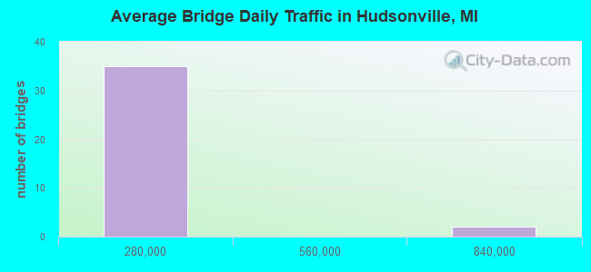
- 1,901,299Total average daily traffic
- 32,411Total average daily truck traffic
- National Bridge Inventory (NBI) Registered Bridges for Hudsonville
- No street view available for this location
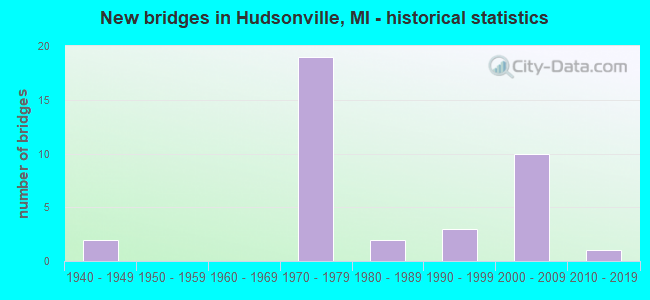
- New bridges - historical statistics
- 21940-1949
- 191970-1979
- 21980-1989
- 31990-1999
- 102000-2009
- 12010-2019
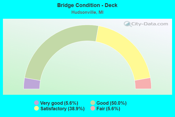
- Bridge Condition - Deck
- 5.6%Very good
- 50.0%Good
- 38.9%Satisfactory
- 5.6%Fair
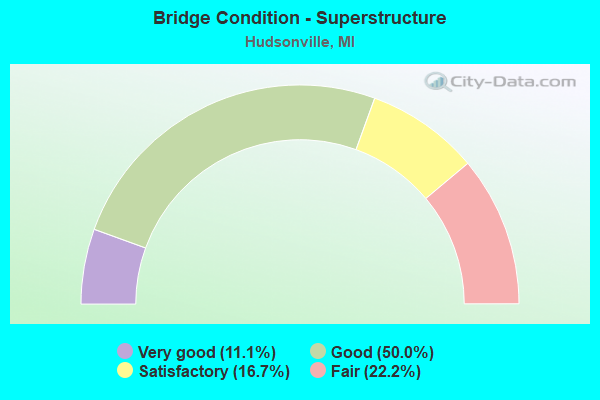
- Bridge Condition - Superstructure
- 11.1%Very good
- 50.0%Good
- 16.7%Satisfactory
- 22.2%Fair
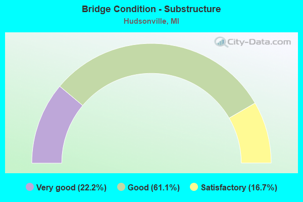
- Bridge Condition - Substructure
- 22.2%Very good
- 61.1%Good
- 16.7%Satisfactory
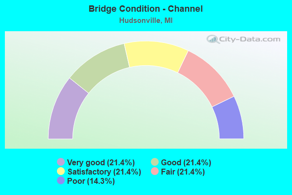
- Bridge Condition - Channel
- 21.4%Very good
- 21.4%Good
- 21.4%Satisfactory
- 21.4%Fair
- 14.3%Poor
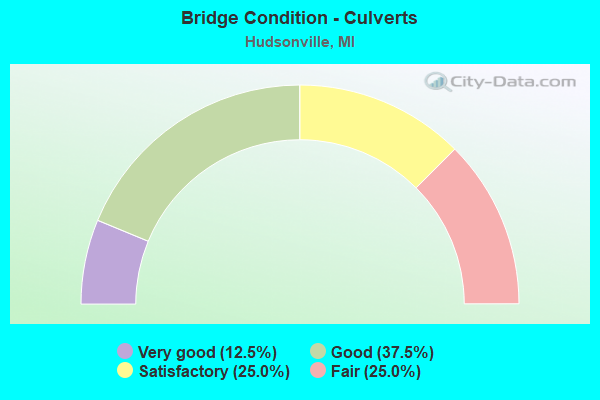
- Bridge Condition - Culverts
- 12.5%Very good
- 37.5%Good
- 25.0%Satisfactory
- 25.0%Fair
Find on map >> Show street view
Structure Number: 895, Location: 3.5 MI SW OF NILES (Lat: 41.808350, Lng: -86.316164), Route carried "on" structure: Ramp US 31, Year Built: 1979, Status: Open, Structure Length: 4.97m (16.31ft), Average Daily Traffic: 8,122 (year 2007), Truck Traffic: 13%, Average Future Daily Traffic: 9,964 (year 2018), Design Load: HS 25 or greater, Features Intersected: AMTRAK RR
Minimum Vertical Clearance: 30.48m (100.00ft), Kilometerpoint: 5.617, Lanes on structure: 2, Owner: State Highway Agency, Approaching Roadway Width: 12.5m (41.0ft), Skew: 1 degrees, Material/Design: Prestressed concrete, Design/Construction: Stringer/Multi-beam, Number Of Spans In Main Unit: 3, Length of Maximum Span: 16.4m (53.8ft), Curb-To-Curb Width: 13.1m (43.0ft), Out-to-Out Width: 13.9m (45.6ft)
Condition: Deck: Satisfactory, Superstructure: Fair, Substructure: Satisfactory, Operating Rating: 81.6 metric tons, Method Used To Determine Operating Rating: Load Factor (LF) rating reported by rating factor (RF) method using MS18 loading, Inventory Rating: 48.9 metric tons, Method Used To Determine Inventory Rating: Load Factor (LF) rating reported by rating factor (RF) method using MS18 loading, Structural Evaluation: Somewhat better than minimum adequacy, Deck Geometry: Superior to present desirable criteria, Underclear: Equal to present minimum criteria, Approach Roadway Alignment: Equal to present desirable criteria, Designated Inspection Frequency: Every 24 months, Inspection Date: May 2020, Deck Structure Type: Concrete Cast-file-Place, Wearing Surface/Protective System: Wearing Surface: Monolithic Concrete, Deck Protection: Epoxy Coated Reinforcing
Find on map >> Show street view
Structure Number: 8712, Location: 4.9 MI SW OF KENT CO LINE (Lat: 42.870025, Lng: -85.862236), Route carried "on" structure: State highway 121, Year Built: 1949, Status: Open, Structure Length: 1.06m (3.48ft), Average Daily Traffic: 12,246 (year 2007), Truck Traffic: 9%, Average Future Daily Traffic: 18,214 (year 2018), Design Load: HS 20, Features Intersected: RUSH CREEK
Minimum Vertical Clearance: 30.48m (100.00ft), Kilometerpoint: 12.717, Lanes on structure: 6, Owner: State Highway Agency, Approaching Roadway Width: 38.1m (125.0ft), Skew: 20 degrees, Material/Design: Steel, Design/Construction: Stringer/Multi-beam, Number Of Spans In Main Unit: 1, Length of Maximum Span: 10.6m (34.8ft), Curb or Sidewalk Widths: Left: 1.8m (5.9ft), Right: 1.8m (5.9ft), Curb-To-Curb Width: 37.2m (122.0ft), Out-to-Out Width: 41.7m (136.8ft)
Condition: Deck: Satisfactory, Superstructure: Satisfactory, Substructure: Good, Channel: Fair, Operating Rating: 72.9 metric tons, Method Used To Determine Operating Rating: Load Factor (LF) rating reported by rating factor (RF) method using MS18 loading, Inventory Rating: 43.7 metric tons, Method Used To Determine Inventory Rating: Load Factor (LF) rating reported by rating factor (RF) method using MS18 loading, Structural Evaluation: Equal to present minimum criteria, Deck Geometry: Superior to present desirable criteria, Waterway Adequacy: Equal to present desirable criteria, Approach Roadway Alignment: Equal to present minimum criteria, Length Of Structure Improvement: 1.07m (3.51ft), Designated Inspection Frequency: Every 24 months, Inspection Date: May 2020, Bridge Improvement Cost: $24,000, Roadway Improvement Cost: $3,000, Total Project Cost: $38,000, Deck Structure Type: Concrete Cast-file-Place, Wearing Surface/Protective System: Wearing Surface: Monolithic Concrete
Find on map >> Show street view
Structure Number: 8713, Location: 3.7 MI SW OF KENT CO LINE (Lat: 42.880381, Lng: -85.843389), Route carried "on" structure: State highway 121, Year Built: 1941, Status: Open, Structure Length: 1.25m (4.10ft), Average Daily Traffic: 7,552 (year 2007), Truck Traffic: 8%, Average Future Daily Traffic: 9,582 (year 2018), Design Load: H 20, Features Intersected: RUSH CREEK
Minimum Vertical Clearance: 30.48m (100.00ft), Kilometerpoint: 14.641, Lanes on structure: 2, Base Highway Network: Yes (Inventory Route: 370, Subroute: 52), Owner: State Highway Agency, Approaching Roadway Width: 12.8m (42.0ft), Material/Design: Steel, Design/Construction: Stringer/Multi-beam, Number Of Spans In Main Unit: 1, Length of Maximum Span: 12.5m (41.0ft), Curb-To-Curb Width: 12.2m (40.0ft), Out-to-Out Width: 13.8m (45.3ft)
Condition: Deck: Satisfactory, Superstructure: Fair, Substructure: Good, Channel: Good, Operating Rating: 54.8 metric tons, Method Used To Determine Operating Rating: Load Factor (LF) rating reported by rating factor (RF) method using MS18 loading, Inventory Rating: 32.7 metric tons, Method Used To Determine Inventory Rating: Load Factor (LF) rating reported by rating factor (RF) method using MS18 loading, Structural Evaluation: Somewhat better than minimum adequacy, Deck Geometry: Better than present minimum criteria, Waterway Adequacy: Equal to present desirable criteria, Approach Roadway Alignment: Equal to present minimum criteria, Length Of Structure Improvement: 1.25m (4.10ft), Designated Inspection Frequency: Every 24 months, Inspection Date: April 2020, Bridge Improvement Cost: $25,000, Roadway Improvement Cost: $3,000, Total Project Cost: $30,000, Deck Structure Type: Concrete Cast-file-Place, Wearing Surface/Protective System: Wearing Surface: Monolithic Concrete
Find on map >> Show street view
Structure Number: 8738, Location: 4.4 MI NE OF I 96 BL (Lat: 42.835267, Lng: -85.900569), Route carried "on" structure: Interstate 196, Year Built: 1971, Status: Open, Structure Length: 3.62m (11.88ft), Average Daily Traffic: 15,999 (year 2007), Truck Traffic: 13%, Average Future Daily Traffic: 21,239 (year 2018), Design Load: HS 20, Features Intersected: 48TH AVE
Minimum Vertical Clearance: 30.48m (100.00ft), Kilometerpoint: 14.227, Lanes on structure: 2, Lanes under structure: 2, Base Highway Network: Yes (Inventory Route: 75, Subroute: 4), Owner: State Highway Agency, Approaching Roadway Width: 13.7m (44.9ft), Skew: 2 degrees, Material/Design: Steel, Design/Construction: Stringer/Multi-beam, Number Of Spans In Main Unit: 3, Length of Maximum Span: 16.4m (53.8ft), Curb-To-Curb Width: 12.8m (42.0ft), Out-to-Out Width: 13.3m (43.6ft)
Condition: Deck: Good, Superstructure: Good, Substructure: Good, Operating Rating: 80.4 metric tons, Method Used To Determine Operating Rating: Load Factor (LF), Inventory Rating: 48.1 metric tons, Method Used To Determine Inventory Rating: Load Factor (LF), Structural Evaluation: Better than present minimum criteria, Deck Geometry: Equal to present desirable criteria, Underclear: Somewhat better than minimum adequacy, Approach Roadway Alignment: Equal to present desirable criteria, Designated Inspection Frequency: Every 24 months, Inspection Date: May 2020, Deck Structure Type: Concrete Cast-file-Place, Wearing Surface/Protective System: Wearing Surface: Monolithic Concrete
Find on map >> Show street view
Structure Number: 8739, Location: 4.4 MI NE I 96 BL (Lat: 42.836453, Lng: -85.900514), Route carried "on" structure: Interstate 196, Year Built: 1971, Status: Open, Structure Length: 3.62m (11.88ft), Average Daily Traffic: 15,999 (year 2007), Truck Traffic: 13%, Average Future Daily Traffic: 21,239 (year 2018), Design Load: HS 20, Features Intersected: 48TH AVE
Minimum Vertical Clearance: 30.48m (100.00ft), Kilometerpoint: 14.345, Lanes on structure: 2, Lanes under structure: 2, Base Highway Network: Yes (Inventory Route: 75, Subroute: 3), Owner: State Highway Agency, Approaching Roadway Width: 13.7m (44.9ft), Skew: 2 degrees, Material/Design: Steel, Design/Construction: Stringer/Multi-beam, Number Of Spans In Main Unit: 3, Length of Maximum Span: 17.0m (55.8ft), Curb-To-Curb Width: 12.8m (42.0ft), Out-to-Out Width: 13.3m (43.6ft)
Condition: Deck: Good, Superstructure: Good, Substructure: Good, Operating Rating: 68.0 metric tons, Method Used To Determine Operating Rating: Load Factor (LF), Inventory Rating: 40.7 metric tons, Method Used To Determine Inventory Rating: Load Factor (LF), Structural Evaluation: Better than present minimum criteria, Deck Geometry: Equal to present desirable criteria, Underclear: Somewhat better than minimum adequacy, Approach Roadway Alignment: Equal to present desirable criteria, Designated Inspection Frequency: Every 24 months, Inspection Date: May 2020, Deck Structure Type: Concrete Cast-file-Place, Wearing Surface/Protective System: Wearing Surface: Monolithic Concrete
Find on map >> Show street view
Structure Number: 874, Location: 1 MI S OF HUDSONVILLE (Lat: 42.848564, Lng: -85.861350), Route carried "on" structure: Interstate 196, Year Built: 1972, Status: Open, Structure Length: 3.66m (12.01ft), Average Daily Traffic: 20,761 (year 2007), Truck Traffic: 12%, Average Future Daily Traffic: 26,499 (year 2018), Design Load: HS 20, Features Intersected: 32ND AVE
Minimum Vertical Clearance: 30.48m (100.00ft), Kilometerpoint: 17.868, Lanes on structure: 2, Lanes under structure: 2, Base Highway Network: Yes (Inventory Route: 75, Subroute: 4), Owner: State Highway Agency, Approaching Roadway Width: 14.3m (46.9ft), Skew: 1 degrees, Material/Design: Steel, Design/Construction: Stringer/Multi-beam, Number Of Spans In Main Unit: 1, Length of Maximum Span: 35.7m (117.1ft), Curb-To-Curb Width: 12.3m (40.4ft), Out-to-Out Width: 13.4m (44.0ft)
Condition: Deck: Good, Superstructure: Satisfactory, Substructure: Satisfactory, Operating Rating: 74.2 metric tons, Method Used To Determine Operating Rating: Load Factor (LF) rating reported by rating factor (RF) method using MS18 loading, Inventory Rating: 44.4 metric tons, Method Used To Determine Inventory Rating: Load Factor (LF) rating reported by rating factor (RF) method using MS18 loading, Structural Evaluation: Equal to present minimum criteria, Deck Geometry: Better than present minimum criteria, Underclear: High priority of corrective action, Approach Roadway Alignment: Equal to present desirable criteria, Designated Inspection Frequency: Every 18 months, Inspection Date: November 2020, Deck Structure Type: Concrete Cast-file-Place, Wearing Surface/Protective System: Wearing Surface: Epoxy Overlay
Find on map >> Show street view
Structure Number: 8741, Location: 1 MI S OF HUDSONVILLE (Lat: 42.848964, Lng: -85.861322), Route carried "on" structure: Interstate 196, Year Built: 1972, Status: Open, Structure Length: 3.66m (12.01ft), Average Daily Traffic: 27,778 (year 2019), Truck Traffic: 13%, Average Future Daily Traffic: 15,700 (year 2039), Design Load: HS 20, Features Intersected: 32ND AVE
Minimum Vertical Clearance: 30.48m (100.00ft), Kilometerpoint: 17.934, Lanes on structure: 2, Lanes under structure: 2, Base Highway Network: Yes (Inventory Route: 75, Subroute: 3), Owner: State Highway Agency, Approaching Roadway Width: 14.3m (46.9ft), Skew: 1 degrees, Material/Design: Steel, Design/Construction: Stringer/Multi-beam, Number Of Spans In Main Unit: 1, Length of Maximum Span: 35.7m (117.1ft), Curb-To-Curb Width: 12.3m (40.4ft), Out-to-Out Width: 13.4m (44.0ft)
Condition: Deck: Good, Superstructure: Fair, Substructure: Satisfactory, Operating Rating: 97.2 metric tons, Method Used To Determine Operating Rating: Load Factor (LF) rating reported by rating factor (RF) method using MS18 loading, Inventory Rating: 65.4 metric tons, Method Used To Determine Inventory Rating: Load Factor (LF) rating reported by rating factor (RF) method using MS18 loading, Structural Evaluation: Somewhat better than minimum adequacy, Deck Geometry: Better than present minimum criteria, Underclear: High priority of corrective action, Approach Roadway Alignment: Equal to present desirable criteria, Designated Inspection Frequency: Every 24 months, Inspection Date: May 2020, Deck Structure Type: Concrete Cast-file-Place, Wearing Surface/Protective System: Wearing Surface: Epoxy Overlay
Find on map >> Show street view
Structure Number: 8742, Location: 2.2 MI N OF JAMESTOWN (Lat: 42.858008, Lng: -85.836364), Route carried "on" structure: Interstate 196, Year Built: 1972, Status: Open, Structure Length: 3.82m (12.53ft), Average Daily Traffic: 20,761 (year 2007), Truck Traffic: 12%, Average Future Daily Traffic: 26,499 (year 2018), Design Load: HS 20, Features Intersected: 22ND AVE
Minimum Vertical Clearance: 30.48m (100.00ft), Kilometerpoint: 20.175, Lanes on structure: 2, Lanes under structure: 2, Base Highway Network: Yes (Inventory Route: 75, Subroute: 4), Owner: State Highway Agency, Approaching Roadway Width: 12.4m (40.7ft), Skew: 2 degrees, Material/Design: Steel, Design/Construction: Stringer/Multi-beam, Number Of Spans In Main Unit: 3, Length of Maximum Span: 17.5m (57.4ft), Curb-To-Curb Width: 12.4m (40.7ft), Out-to-Out Width: 13.4m (44.0ft)
Condition: Deck: Good, Superstructure: Good, Substructure: Good, Operating Rating: 61.6 metric tons, Method Used To Determine Operating Rating: Load Factor (LF) rating reported by rating factor (RF) method using MS18 loading, Inventory Rating: 36.6 metric tons, Method Used To Determine Inventory Rating: Load Factor (LF) rating reported by rating factor (RF) method using MS18 loading, Structural Evaluation: Better than present minimum criteria, Deck Geometry: Better than present minimum criteria, Underclear: Somewhat better than minimum adequacy, Approach Roadway Alignment: Equal to present desirable criteria, Designated Inspection Frequency: Every 24 months, Inspection Date: May 2020, Deck Structure Type: Concrete Cast-file-Place, Wearing Surface/Protective System: Wearing Surface: Epoxy Overlay
Find on map >> Show street view
Structure Number: 8743, Location: 2.2 MI N OF JAMESTOWN (Lat: 42.858433, Lng: -85.836364), Route carried "on" structure: Interstate 196, Year Built: 1972, Year Reconstructed: 2001, Status: Open, Structure Length: 3.96m (12.99ft), Average Daily Traffic: 27,778 (year 2019), Truck Traffic: 13%, Average Future Daily Traffic: 15,700 (year 2039), Design Load: HS 25 or greater, Features Intersected: 22ND AVE
Minimum Vertical Clearance: 30.48m (100.00ft), Kilometerpoint: 20.241, Lanes on structure: 3, Lanes under structure: 2, Base Highway Network: Yes (Inventory Route: 75, Subroute: 3), Owner: State Highway Agency, Approaching Roadway Width: 17.2m (56.4ft), Skew: 3 degrees, Material/Design: Steel, Design/Construction: Stringer/Multi-beam, Number Of Spans In Main Unit: 3, Length of Maximum Span: 18.2m (59.7ft), Curb-To-Curb Width: 18.2m (59.7ft), Out-to-Out Width: 19.0m (62.3ft)
Condition: Deck: Very good, Superstructure: Good, Substructure: Very good, Operating Rating: 89.4 metric tons, Method Used To Determine Operating Rating: Load Factor (LF) rating reported by rating factor (RF) method using MS18 loading, Inventory Rating: 53.5 metric tons, Method Used To Determine Inventory Rating: Load Factor (LF) rating reported by rating factor (RF) method using MS18 loading, Structural Evaluation: Better than present minimum criteria, Deck Geometry: Better than present minimum criteria, Underclear: Somewhat better than minimum adequacy, Approach Roadway Alignment: Equal to present desirable criteria, Designated Inspection Frequency: Every 24 months, Inspection Date: May 2020, Deck Structure Type: Concrete Cast-file-Place, Wearing Surface/Protective System: Wearing Surface: Monolithic Concrete, Deck Protection: Epoxy Coated Reinforcing
Find on map >> Show street view
Structure Number: 8811, Location: 0.75 MILES E OF 48TH AVE (Lat: 42.811103, Lng: -85.886528), Route carried "on" structure: County highway 7010, Year Built: 1980, Status: Open, Structure Length: 0.97m (3.18ft), Average Daily Traffic: 5,810 (year 2020), Average Future Daily Traffic: 10,500 (year 2040), Design Load: HS 20, Features Intersected: KAMPEN-STRUIK DRAIN, Facility Carried by Structure: BYRON ROAD
Minimum Vertical Clearance: 30.48m (100.00ft), Kilometerpoint: 19.561, Lanes on structure: 2, Owner: County Highway Agency, Approaching Roadway Width: 12.2m (40.0ft), Material/Design: Prestressed concrete, Design/Construction: Box Beam or Girders - Multiple, Number Of Spans In Main Unit: 1, Length of Maximum Span: 9.1m (29.9ft), Curb-To-Curb Width: 12.8m (42.0ft), Out-to-Out Width: 12.9m (42.3ft)
Condition: Deck: Fair, Superstructure: Fair, Substructure: Good, Channel: Good, Operating Rating: 60.6 metric tons, Method Used To Determine Operating Rating: Load Factor (LF) rating reported by rating factor (RF) method using MS18 loading, Inventory Rating: 36.3 metric tons, Method Used To Determine Inventory Rating: Load Factor (LF) rating reported by rating factor (RF) method using MS18 loading, Structural Evaluation: Somewhat better than minimum adequacy, Deck Geometry: Somewhat better than minimum adequacy, Waterway Adequacy: Equal to present desirable criteria, Approach Roadway Alignment: Equal to present desirable criteria, Designated Inspection Frequency: Every 24 months, Inspection Date: October 2020, Deck Structure Type: Concrete Precast Panels, Wearing Surface/Protective System: Wearing Surface: Bituminous, Membrane: Preformed Fabric
Find on map >> Show street view
Structure Number: 8883, Location: SECTION 29 GEORGETOWN TWP (Lat: 42.878172, Lng: -85.871456), Route carried "on" structure: County highway , Year Built: 1972, Status: Open, Structure Length: 0.91m (2.99ft), Average Daily Traffic: 4,666 (year 2019), Truck Traffic: 5%, Average Future Daily Traffic: 8,430 (year 2039), Design Load: H 20, Features Intersected: RUSH CREEK, Facility Carried by Structure: 36TH AVENUE
Minimum Vertical Clearance: 30.48m (100.00ft), Kilometerpoint: 2.421, Lanes on structure: 2, Owner: County Highway Agency, Approaching Roadway Width: 12.2m (40.0ft), Material/Design: Steel, Design/Construction: Culvert, Number Of Spans In Main Unit: 3, Length of Maximum Span: 2.4m (7.9ft), Out-to-Out Width: 10.9m (35.8ft)
Condition: Channel: Good, Culverts: Satisfactory, Operating Rating: 35.6 metric tons, Method Used To Determine Operating Rating: Load Factor (LF) rating reported by rating factor (RF) method using MS18 loading, Inventory Rating: 21.4 metric tons, Method Used To Determine Inventory Rating: Load Factor (LF) rating reported by rating factor (RF) method using MS18 loading, Structural Evaluation: Somewhat better than minimum adequacy, Waterway Adequacy: Equal to present minimum criteria, Approach Roadway Alignment: Equal to present minimum criteria, Designated Inspection Frequency: Every 24 months, Inspection Date: December 2020, Wearing Surface/Protective System: Wearing Surface: Bituminous
Find on map >> Show street view
Structure Number: 8893, Location: SECTION 30 JAMESTOWN TWP (Lat: 42.796658, Lng: -85.887228), Route carried "on" structure: County highway , Year Built: 1970, Status: Open, Structure Length: 0.79m (2.59ft), Average Daily Traffic: 620 (year 2020), Truck Traffic: 5%, Average Future Daily Traffic: 1,110 (year 2040), Design Load: H 20, Features Intersected: KAMPEN STRUIK DRAIN, Facility Carried by Structure: PERRY ST
Minimum Vertical Clearance: 30.48m (100.00ft), Kilometerpoint: 6.943, Lanes on structure: 2, Owner: County Highway Agency, Approaching Roadway Width: 8.5m (27.9ft), Material/Design: Prestressed concrete, Design/Construction: Box Beam or Girders - Multiple, Number Of Spans In Main Unit: 1, Length of Maximum Span: 7.6m (24.9ft), Curb-To-Curb Width: 11.0m (36.1ft), Out-to-Out Width: 11.1m (36.4ft)
Condition: Deck: Satisfactory, Superstructure: Satisfactory, Substructure: Good, Channel: Very good, Operating Rating: 67.4 metric tons, Method Used To Determine Operating Rating: Load Factor (LF) rating reported by rating factor (RF) method using MS18 loading, Inventory Rating: 40.5 metric tons, Method Used To Determine Inventory Rating: Load Factor (LF) rating reported by rating factor (RF) method using MS18 loading, Structural Evaluation: Equal to present minimum criteria, Deck Geometry: Better than present minimum criteria, Waterway Adequacy: Equal to present desirable criteria, Approach Roadway Alignment: Equal to present desirable criteria, Designated Inspection Frequency: Every 24 months, Inspection Date: October 2020, Deck Structure Type: Concrete Precast Panels, Wearing Surface/Protective System: Wearing Surface: Bituminous, Membrane: Preformed Fabric
Find on map >> Show street view
Structure Number: 8896, Location: SECTION 30 JAMESTOWN TWP (Lat: 42.785803, Lng: -85.881094), Route carried "on" structure: County highway , Year Built: 1998, Status: Open, Structure Length: 1.83m (6.00ft), Average Daily Traffic: 1,190 (year 2020), Truck Traffic: 5%, Average Future Daily Traffic: 2,150 (year 2040), Design Load: HS 20, Features Intersected: KAMPEN STRUIK DRAIN, Facility Carried by Structure: 40TH AVE
Minimum Vertical Clearance: 30.48m (100.00ft), Kilometerpoint: 3.624, Lanes on structure: 2, Owner: County Highway Agency, Approaching Roadway Width: 11.0m (36.1ft), Material/Design: Prestressed concrete, Design/Construction: Box Beam or Girders - Multiple, Number Of Spans In Main Unit: 1, Length of Maximum Span: 17.9m (58.7ft), Curb-To-Curb Width: 11.0m (36.1ft), Out-to-Out Width: 11.4m (37.4ft)
Condition: Deck: Good, Superstructure: Good, Substructure: Very good, Channel: Very good, Operating Rating: 74.2 metric tons, Method Used To Determine Operating Rating: Load Factor (LF) rating reported by rating factor (RF) method using MS18 loading, Inventory Rating: 44.4 metric tons, Method Used To Determine Inventory Rating: Load Factor (LF) rating reported by rating factor (RF) method using MS18 loading, Structural Evaluation: Better than present minimum criteria, Deck Geometry: Equal to present minimum criteria, Waterway Adequacy: Equal to present desirable criteria, Approach Roadway Alignment: Equal to present desirable criteria, Designated Inspection Frequency: Every 24 months, Inspection Date: October 2020, Deck Structure Type: Concrete Precast Panels, Wearing Surface/Protective System: Wearing Surface: Bituminous, Membrane: Preformed Fabric
Find on map >> Show street view
Structure Number: 8948, Location: HUDSONVILLE (Lat: 42.870908, Lng: -85.862692), Route carried "on" structure: City street 2001, Year Built: 1983, Status: Posted for load, Structure Length: 1.06m (3.48ft), Average Daily Traffic: 750 (year 2004), Truck Traffic: 4%, Average Future Daily Traffic: 1,358 (year 2024), Design Load: HS 20, Features Intersected: BUTTERMILK CREEK, Facility Carried by Structure: VAN BUREN ST
Minimum Vertical Clearance: 30.48m (100.00ft), Kilometerpoint: 7.981, Lanes on structure: 2, Owner: City or Municipal Highway Agency, Approaching Roadway Width: 12.2m (40.0ft), Material/Design: Steel, Design/Construction: Culvert, Number Of Spans In Main Unit: 2, Length of Maximum Span: 4.8m (15.7ft), Curb or Sidewalk Widths: Left: 1.5m (4.9ft), Right: 1.5m (4.9ft)
Condition: Channel: Satisfactory, Culverts: Fair, Operating Rating: 26.9 metric tons, Method Used To Determine Operating Rating: Load and Resistance Factor Rating (LRFR) rating reported by rating factor(RF) method using HL-93 loadings, Inventory Rating: 15.9 metric tons, Method Used To Determine Inventory Rating: Load and Resistance Factor Rating (LRFR) rating reported by rating factor(RF) method using HL-93 loadings, Structural Evaluation: Meets minimum limits, Waterway Adequacy: Equal to present desirable criteria, Approach Roadway Alignment: Equal to present desirable criteria, Bridge Posting: Required (Relationship of Operating Rating to Maximum Legal Load: 20.0 - 29.9% below), Designated Inspection Frequency: Every 24 months, Inspection Date: September 2020
Find on map >> Show street view
Structure Number: 8949, Location: HUDSONVILLE (Lat: 42.880883, Lng: -85.855086), Route carried "on" structure: City street 2001, Year Built: 1990, Status: Open, Structure Length: 1.70m (5.58ft), Average Daily Traffic: 11,262 (year 2004), Truck Traffic: 10%, Average Future Daily Traffic: 20,384 (year 2024), Design Load: HS 20, Features Intersected: RUSH CREEK, Facility Carried by Structure: BALSAM DR
Minimum Vertical Clearance: 30.48m (100.00ft), Kilometerpoint: 1.246, Lanes on structure: 2, Owner: City or Municipal Highway Agency, Approaching Roadway Width: 12.2m (40.0ft), Skew: 1 degrees, Material/Design: Prestressed concrete, Design/Construction: Box Beam or Girders - Multiple, Number Of Spans In Main Unit: 1, Length of Maximum Span: 15.8m (51.8ft), Curb or Sidewalk Widths: Left: 1.5m (4.9ft), Right: 1.5m (4.9ft), Curb-To-Curb Width: 14.3m (46.9ft), Out-to-Out Width: 18.1m (59.4ft)
Condition: Deck: Good, Superstructure: Good, Substructure: Very good, Channel: Fair, Operating Rating: 42.6 metric tons, Method Used To Determine Operating Rating: Load Factor (LF), Inventory Rating: 25.5 metric tons, Method Used To Determine Inventory Rating: Load Factor (LF), Structural Evaluation: Equal to present minimum criteria, Deck Geometry: Superior to present desirable criteria, Waterway Adequacy: Equal to present desirable criteria, Approach Roadway Alignment: Equal to present desirable criteria, Designated Inspection Frequency: Every 24 months, Inspection Date: September 2020, Deck Structure Type: Concrete Cast-file-Place, Wearing Surface/Protective System: Wearing Surface: Monolithic Concrete, Deck Protection: Epoxy Coated Reinforcing
Find on map >> Show street view
Structure Number: 895, Location: IN HUDSONVILLE (Lat: 42.853233, Lng: -85.871903), Route carried "on" structure: City street , Year Built: 1990, Status: Open, Structure Length: 1.03m (3.38ft), Average Daily Traffic: 4,681 (year 2004), Truck Traffic: 5%, Average Future Daily Traffic: 8,454 (year 2024), Design Load: HS 20, Features Intersected: BUTTERMILK CREEK, Facility Carried by Structure: HIGHLAND DRIVE
Minimum Vertical Clearance: 30.48m (100.00ft), Kilometerpoint: 0.879, Lanes on structure: 2, Owner: City or Municipal Highway Agency, Approaching Roadway Width: 12.2m (40.0ft), Material/Design: Concrete, Design/Construction: Culvert, Number Of Spans In Main Unit: 1, Length of Maximum Span: 9.7m (31.8ft), Curb or Sidewalk Widths: Left: 2.4m (7.9ft), Right: 1.5m (4.9ft), Out-to-Out Width: 20.4m (66.9ft)
Condition: Channel: Satisfactory, Culverts: Good, Operating Rating: 66.7 metric tons, Method Used To Determine Operating Rating: Load Factor (LF) rating reported by rating factor (RF) method using MS18 loading, Inventory Rating: 39.9 metric tons, Method Used To Determine Inventory Rating: Load Factor (LF) rating reported by rating factor (RF) method using MS18 loading, Structural Evaluation: Better than present minimum criteria, Waterway Adequacy: Equal to present desirable criteria, Approach Roadway Alignment: Equal to present desirable criteria, Designated Inspection Frequency: Every 24 months, Inspection Date: September 2020
Find on map >> Show street view
Structure Number: 8951, Location: HUDSONVILLE (Lat: 42.871978, Lng: -85.862747), Route carried "on" structure: City street 2001, Year Built: 2015, Status: Open, Structure Length: 0.79m (2.59ft), Average Daily Traffic: 2,446 (year 2014), Truck Traffic: 5%, Average Future Daily Traffic: 4,426 (year 2034), Design Load: Greater than HL93, Features Intersected: BUTTERMILK CREEK, Facility Carried by Structure: OAK STREET
Minimum Vertical Clearance: 30.48m (100.00ft), Kilometerpoint: 0.702, Lanes on structure: 2, Owner: City or Municipal Highway Agency, Approaching Roadway Width: 9.4m (30.8ft), Material/Design: Concrete, Design/Construction: Culvert, Number Of Spans In Main Unit: 1, Length of Maximum Span: 7.3m (24.0ft), Curb or Sidewalk Widths: Left: 1.7m (5.6ft), Right: 1.7m (5.6ft), Curb-To-Curb Width: 9.1m (29.9ft), Out-to-Out Width: 13.2m (43.3ft)
Condition: Channel: Very good, Culverts: Very good, Operating Rating: 49.2 metric tons, Method Used To Determine Operating Rating: Load and Resistance Factor Rating (LRFR) rating reported by rating factor(RF) method using HL-93 loadings, Inventory Rating: 37.9 metric tons, Method Used To Determine Inventory Rating: Load and Resistance Factor Rating (LRFR) rating reported by rating factor(RF) method using HL-93 loadings, Structural Evaluation: Equal to present desirable criteria, Deck Geometry: Meets minimum limits, Waterway Adequacy: Equal to present desirable criteria, Approach Roadway Alignment: Equal to present minimum criteria, Designated Inspection Frequency: Every 24 months, Inspection Date: September 2020, Wearing Surface/Protective System: Wearing Surface: Bituminous
Find on map >> Show street view
Structure Number: 12936, Location: GEORGETOWN TWP SEC 34 (Lat: 42.861975, Lng: -85.820244), Route carried "on" structure: State highway 6, Year Built: 2001, Status: Open, Structure Length: 5.69m (18.67ft), Average Daily Traffic: 16,313 (year 2007), Truck Traffic: 8%, Average Future Daily Traffic: 19,100 (year 2015), Design Load: HS 25 or greater, Features Intersected: I-196 EB
Minimum Vertical Clearance: 30.48m (100.00ft), Kilometerpoint: 0.917, Lanes on structure: 2, Lanes under structure: 2, Base Highway Network: Yes (Inventory Route: 370, Subroute: 7), Owner: State Highway Agency, Approaching Roadway Width: 12.6m (41.3ft), Skew: 5 degrees, Material/Design: Steel, Design/Construction: Stringer/Multi-beam, Number Of Spans In Main Unit: 1, Length of Maximum Span: 53.9m (176.8ft), Curb-To-Curb Width: 13.2m (43.3ft), Out-to-Out Width: 14.2m (46.6ft)
Condition: Deck: Satisfactory, Superstructure: Good, Substructure: Good, Operating Rating: 91.4 metric tons, Method Used To Determine Operating Rating: Load Factor (LF), Inventory Rating: 54.9 metric tons, Method Used To Determine Inventory Rating: Load Factor (LF), Structural Evaluation: Better than present minimum criteria, Deck Geometry: Superior to present desirable criteria, Underclear: Superior to present desirable criteria, Approach Roadway Alignment: Equal to present desirable criteria, Designated Inspection Frequency: Every 24 months, Inspection Date: September 2020, Deck Structure Type: Concrete Cast-file-Place, Wearing Surface/Protective System: Wearing Surface: Monolithic Concrete, Deck Protection: Epoxy Coated Reinforcing
Find on map >> Show street view
Structure Number: 12937, Location: GEORGETOWN TWP SEC 35 (Lat: 42.860125, Lng: -85.816511), Route carried "on" structure: State highway 6, Year Built: 2004, Status: Open, Structure Length: 6.95m (22.80ft), Average Daily Traffic: 700 (year 2001), Truck Traffic: 8%, Average Future Daily Traffic: 700 (year 2015), Design Load: HS 25 or greater, Features Intersected: I-196 WB , RAMP C
Minimum Vertical Clearance: 30.48m (100.00ft), Kilometerpoint: 0.748, Lanes on structure: 1, Lanes under structure: 2, Base Highway Network: Yes (Inventory Route: 370, Subroute: 67), Owner: State Highway Agency, Approaching Roadway Width: 9.3m (30.5ft), Material/Design: Steel, Design/Construction: Box Beam or Girders - Single/Spread, Number Of Spans In Main Unit: 1, Length of Maximum Span: 67.1m (220.1ft), Curb-To-Curb Width: 9.3m (30.5ft), Out-to-Out Width: 10.3m (33.8ft)
Condition: Deck: Good, Superstructure: Very good, Substructure: Good, Inventory Rating: 69.5 metric tons, Method Used To Determine Inventory Rating: Load Factor (LF), Structural Evaluation: Better than present minimum criteria, Deck Geometry: Equal to present minimum criteria, Underclear: Equal to present minimum criteria, Approach Roadway Alignment: Better than present minimum criteria, Designated Inspection Frequency: Every 24 months, Inspection Date: September 2020, Deck Structure Type: Concrete Cast-file-Place, Wearing Surface/Protective System: Wearing Surface: Monolithic Concrete, Deck Protection: Epoxy Coated Reinforcing
Find on map >> Show street view
Structure Number: 12938, Location: GEORGETOWN TWP 35 (Lat: 42.862958, Lng: -85.815189), Route carried "on" structure: Ramp Interstate 196, Year Built: 2004, Status: Open, Structure Length: 8.16m (26.77ft), Average Daily Traffic: 700 (year 2001), Truck Traffic: 8%, Average Future Daily Traffic: 700 (year 2015), Design Load: HS 25 or greater, Features Intersected: I-196 EB
Minimum Vertical Clearance: 30.48m (100.00ft), Kilometerpoint: 0.402, Lanes on structure: 1, Lanes under structure: 2, Owner: State Highway Agency, Approaching Roadway Width: 9.3m (30.5ft), Material/Design: Steel, Design/Construction: Box Beam or Girders - Single/Spread, Number Of Spans In Main Unit: 1, Length of Maximum Span: 79.3m (260.2ft), Curb-To-Curb Width: 9.3m (30.5ft), Out-to-Out Width: 10.3m (33.8ft)
Condition: Deck: Good, Superstructure: Very good, Substructure: Very good, Operating Rating: 90.4 metric tons, Method Used To Determine Operating Rating: Load Factor (LF), Inventory Rating: 54.2 metric tons, Method Used To Determine Inventory Rating: Load Factor (LF), Structural Evaluation: Equal to present desirable criteria, Deck Geometry: Superior to present desirable criteria, Underclear: Superior to present desirable criteria, Approach Roadway Alignment: Better than present minimum criteria, Designated Inspection Frequency: Every 24 months, Inspection Date: September 2020, Deck Structure Type: Concrete Cast-file-Place, Wearing Surface/Protective System: Wearing Surface: Monolithic Concrete, Deck Protection: Epoxy Coated Reinforcing
Find on map >> Show street view
Structure Number: 13055, Location: JAMESTOWN TWP SEC 2 (Lat: 42.856317, Lng: -85.813397), Route carried "on" structure: State highway 6, Year Built: 2002, Status: Open, Structure Length: 5.31m (17.42ft), Average Daily Traffic: 16,313 (year 2007), Truck Traffic: 8%, Average Future Daily Traffic: 19,800 (year 2015), Design Load: HS 25 or greater, Features Intersected: JACKSON ST
Minimum Vertical Clearance: 30.48m (100.00ft), Kilometerpoint: 1.783, Lanes on structure: 3, Lanes under structure: 2, Base Highway Network: Yes (Inventory Route: 370, Subroute: 7), Owner: State Highway Agency, Approaching Roadway Width: 18.3m (60.0ft), Skew: 3 degrees, Material/Design: Prestressed concrete, Design/Construction: Stringer/Multi-beam, Number Of Spans In Main Unit: 3, Length of Maximum Span: 18.1m (59.4ft), Curb-To-Curb Width: 18.0m (59.1ft), Out-to-Out Width: 19.0m (62.3ft)
Condition: Deck: Satisfactory, Superstructure: Good, Substructure: Good, Operating Rating: 68.7 metric tons, Method Used To Determine Operating Rating: Load Factor (LF) rating reported by rating factor (RF) method using MS18 loading, Inventory Rating: 41.1 metric tons, Method Used To Determine Inventory Rating: Load Factor (LF) rating reported by rating factor (RF) method using MS18 loading, Structural Evaluation: Better than present minimum criteria, Deck Geometry: Better than present minimum criteria, Underclear: Somewhat better than minimum adequacy, Approach Roadway Alignment: Superior to present desirable criteria, Designated Inspection Frequency: Every 24 months, Inspection Date: September 2020, Deck Structure Type: Concrete Cast-file-Place, Wearing Surface/Protective System: Wearing Surface: Monolithic Concrete, Deck Protection: Epoxy Coated Reinforcing
Find on map >> Show street view
Structure Number: 13056, Location: JAMESTOWN TWP SEC 2 (Lat: 42.856322, Lng: -85.813978), Route carried "on" structure: State highway 6, Year Built: 2002, Status: Open, Structure Length: 5.31m (17.42ft), Average Daily Traffic: 16,313 (year 2007), Truck Traffic: 8%, Average Future Daily Traffic: 19,800 (year 2015), Design Load: HS 25 or greater, Features Intersected: JACKSON ST
Minimum Vertical Clearance: 30.48m (100.00ft), Kilometerpoint: 1.284, Lanes on structure: 3, Lanes under structure: 2, Base Highway Network: Yes (Inventory Route: 370, Subroute: 6), Owner: State Highway Agency, Approaching Roadway Width: 18.3m (60.0ft), Skew: 3 degrees, Material/Design: Prestressed concrete, Design/Construction: Stringer/Multi-beam, Number Of Spans In Main Unit: 3, Length of Maximum Span: 18.1m (59.4ft), Curb-To-Curb Width: 18.0m (59.1ft), Out-to-Out Width: 19.0m (62.3ft)
Condition: Deck: Satisfactory, Superstructure: Good, Substructure: Good, Operating Rating: 67.4 metric tons, Method Used To Determine Operating Rating: Load Factor (LF) rating reported by rating factor (RF) method using MS18 loading, Inventory Rating: 40.5 metric tons, Method Used To Determine Inventory Rating: Load Factor (LF) rating reported by rating factor (RF) method using MS18 loading, Structural Evaluation: Better than present minimum criteria, Deck Geometry: Better than present minimum criteria, Underclear: Somewhat better than minimum adequacy, Approach Roadway Alignment: Superior to present desirable criteria, Designated Inspection Frequency: Every 24 months, Inspection Date: September 2020, Deck Structure Type: Concrete Cast-file-Place, Wearing Surface/Protective System: Wearing Surface: Monolithic Concrete, Deck Protection: Epoxy Coated Reinforcing
Find on map >> Show street view
Structure Number: 13586, Location: 500 FT W OF 32ND AVENUE (Lat: 42.868397, Lng: -85.863008), Route carried "on" structure: City street , Year Built: 1970, Status: Open, Structure Length: 0.80m (2.62ft), Average Daily Traffic: 500 (year 2010), Truck Traffic: 3%, Average Future Daily Traffic: 700 (year 2030), Design Load: HS 20, Features Intersected: BUTTERMILK CREEK, Facility Carried by Structure: PROSPECT STREET
Minimum Vertical Clearance: 30.48m (100.00ft), Kilometerpoint: 0.167, Lanes on structure: 2, Owner: City or Municipal Highway Agency, Approaching Roadway Width: 11.9m (39.0ft), Material/Design: Steel, Design/Construction: Culvert, Number Of Spans In Main Unit: 2, Length of Maximum Span: 3.7m (12.1ft), Curb or Sidewalk Widths: Left: 2.4m (7.9ft), Right: 2.4m (7.9ft), Curb-To-Curb Width: 11.9m (39.0ft), Out-to-Out Width: 18.3m (60.0ft)
Condition: Channel: Satisfactory, Culverts: Good, Operating Rating: 62.5 metric tons, Method Used To Determine Operating Rating: Load Factor (LF) rating reported by rating factor (RF) method using MS18 loading, Inventory Rating: 57.7 metric tons, Method Used To Determine Inventory Rating: Load Factor (LF) rating reported by rating factor (RF) method using MS18 loading, Structural Evaluation: Better than present minimum criteria, Deck Geometry: Better than present minimum criteria, Waterway Adequacy: Equal to present minimum criteria, Approach Roadway Alignment: Better than present minimum criteria, Designated Inspection Frequency: Every 24 months, Inspection Date: September 2020, Wearing Surface/Protective System: Wearing Surface: Bituminous
Find on map >> Show street view
Structure Number: 13587, Location: 20 FT N OF BARRY STREET (Lat: 42.863894, Lng: -85.861097), Route carried "on" structure: City street , Year Built: 1970, Status: Open, Structure Length: 0.80m (2.62ft), Average Daily Traffic: 15,000 (year 2010), Truck Traffic: 6%, Average Future Daily Traffic: 22,000 (year 2030), Design Load: HS 20, Features Intersected: BUTTERMILK CREEK, Facility Carried by Structure: 32ND AVENUE
Minimum Vertical Clearance: 30.48m (100.00ft), Kilometerpoint: 10.690, Lanes on structure: 4, Base Highway Network: Yes (Inventory Route: 73, Subroute: 8), Owner: City or Municipal Highway Agency, Approaching Roadway Width: 13.4m (44.0ft), Skew: 4 degrees, Material/Design: Steel, Design/Construction: Culvert, Number Of Spans In Main Unit: 2, Length of Maximum Span: 3.7m (12.1ft), Curb or Sidewalk Widths: Left: 0.6m (2.0ft), Right: 0.6m (2.0ft), Curb-To-Curb Width: 13.4m (44.0ft), Out-to-Out Width: 21.3m (69.9ft)
Condition: Channel: Poor, Culverts: Fair, Operating Rating: 97.2 metric tons, Method Used To Determine Operating Rating: Load Factor (LF) rating reported by rating factor (RF) method using MS18 loading, Inventory Rating: 97.2 metric tons, Method Used To Determine Inventory Rating: Load Factor (LF) rating reported by rating factor (RF) method using MS18 loading, Structural Evaluation: Somewhat better than minimum adequacy, Deck Geometry: High priority of replacement, Waterway Adequacy: Equal to present minimum criteria, Approach Roadway Alignment: Better than present minimum criteria, Designated Inspection Frequency: Every 24 months, Inspection Date: September 2020, Wearing Surface/Protective System: Wearing Surface: Bituminous
Find on map >> Show street view
Structure Number: 13588, Location: 0.25 MI S OF CHICAGO DR (Lat: 42.867231, Lng: -85.861331), Route carried "on" structure: City street , Year Built: 1970, Status: Open, Structure Length: 0.80m (2.62ft), Average Daily Traffic: 15,000 (year 2010), Truck Traffic: 6%, Average Future Daily Traffic: 22,000 (year 2030), Design Load: HS 20, Features Intersected: BUTTERMILK CREEK, Facility Carried by Structure: 32ND AVENUE
Minimum Vertical Clearance: 30.48m (100.00ft), Kilometerpoint: 11.029, Lanes on structure: 4, Base Highway Network: Yes (Inventory Route: 73, Subroute: 8), Owner: City or Municipal Highway Agency, Approaching Roadway Width: 13.4m (44.0ft), Skew: 4 degrees, Material/Design: Steel, Design/Construction: Culvert, Number Of Spans In Main Unit: 2, Length of Maximum Span: 3.7m (12.1ft), Curb or Sidewalk Widths: Left: 0.6m (2.0ft), Right: 0.6m (2.0ft), Curb-To-Curb Width: 13.4m (44.0ft), Out-to-Out Width: 21.3m (69.9ft)
Condition: Channel: Fair, Culverts: Satisfactory, Operating Rating: 97.2 metric tons, Method Used To Determine Operating Rating: Load Factor (LF) rating reported by rating factor (RF) method using MS18 loading, Inventory Rating: 97.2 metric tons, Method Used To Determine Inventory Rating: Load Factor (LF) rating reported by rating factor (RF) method using MS18 loading, Structural Evaluation: Equal to present minimum criteria, Deck Geometry: High priority of replacement, Waterway Adequacy: Equal to present minimum criteria, Approach Roadway Alignment: Better than present minimum criteria, Designated Inspection Frequency: Every 24 months, Inspection Date: September 2020, Wearing Surface/Protective System: Wearing Surface: Bituminous
Find on map >> Show street view
Structure Number: 13589, Location: 0.4 MI W OF 32ND AVENUE (Lat: 42.856642, Lng: -85.868939), Route carried "on" structure: City street , Year Built: 1970, Status: Open, Structure Length: 0.80m (2.62ft), Average Daily Traffic: 2,000 (year 2010), Truck Traffic: 5%, Average Future Daily Traffic: 3,000 (year 2030), Design Load: HS 20, Features Intersected: BUTTERMILK CREEK, Facility Carried by Structure: NEW HOLLAND STREET
Minimum Vertical Clearance: 30.48m (100.00ft), Kilometerpoint: 0.798, Lanes on structure: 2, Owner: City or Municipal Highway Agency, Approaching Roadway Width: 7.3m (24.0ft), Material/Design: Steel, Design/Construction: Culvert, Number Of Spans In Main Unit: 2, Length of Maximum Span: 3.7m (12.1ft), Curb or Sidewalk Widths: Left: 0.6m (2.0ft), Right: 0.6m (2.0ft), Curb-To-Curb Width: 7.3m (24.0ft), Out-to-Out Width: 18.3m (60.0ft)
Condition: Channel: Poor, Culverts: Good, Operating Rating: 39.5 metric tons, Method Used To Determine Operating Rating: Load Factor (LF) rating reported by rating factor (RF) method using MS18 loading, Inventory Rating: 32.4 metric tons, Method Used To Determine Inventory Rating: Load Factor (LF) rating reported by rating factor (RF) method using MS18 loading, Structural Evaluation: Better than present minimum criteria, Deck Geometry: Meets minimum limits, Waterway Adequacy: Equal to present minimum criteria, Approach Roadway Alignment: Better than present minimum criteria, Designated Inspection Frequency: Every 24 months, Inspection Date: September 2020, Wearing Surface/Protective System: Wearing Surface: Bituminous
Find on map >> Show street view
Structure Number: 8738, Location: 4.4 MI NE OF I 96 BL (Lat: 42.835267, Lng: -85.900569), Route carried "under" structure: County highway , Year Built: 1971, Structure Length: 0. m, Average Daily Traffic: 800 (year 1997), Truck Traffic: 3%, Features Intersected: 48TH AVE, Facility Carried by Structure: I-196 EB
Minimum Vertical Clearance: 4.67m (15.32ft), Kilometerpoint: 7.509, Lanes on structure: 2, Lanes under structure: 2, Material/Design: Steel, Design/Construction: Stringer/Multi-beam, Length of Maximum Span: 16.4m (53.8ft)
Find on map >> Show street view
Structure Number: 8739, Location: 4.4 MI NE I 96 BL (Lat: 42.836453, Lng: -85.900514), Route carried "under" structure: County highway , Year Built: 1971, Structure Length: 0. m, Average Daily Traffic: 800 (year 1997), Truck Traffic: 3%, Features Intersected: 48TH AVE, Facility Carried by Structure: I-196 WB
Minimum Vertical Clearance: 4.44m (14.57ft), Kilometerpoint: 7.640, Lanes on structure: 2, Lanes under structure: 2, Material/Design: Steel, Design/Construction: Stringer/Multi-beam, Length of Maximum Span: 17.0m (55.8ft)
Find on map >> Show street view
Structure Number: 874, Location: 1 MI S OF HUDSONVILLE (Lat: 42.848564, Lng: -85.861350), Route carried "under" structure: County highway 7079, Year Built: 1972, Structure Length: 0. m, Average Daily Traffic: 9,200 (year 1996), Truck Traffic: 3%, Features Intersected: 32ND AVE, Facility Carried by Structure: I-196 EB
Minimum Vertical Clearance: 4.75m (15.58ft), Kilometerpoint: 9.001, Lanes on structure: 2, Lanes under structure: 2, Material/Design: Steel, Design/Construction: Stringer/Multi-beam, Length of Maximum Span: 35.7m (117.1ft)
Find on map >> Show street view
Structure Number: 8741, Location: 1 MI S OF HUDSONVILLE (Lat: 42.848964, Lng: -85.861322), Route carried "under" structure: County highway 7079, Year Built: 1972, Structure Length: 0. m, Average Daily Traffic: 9,200 (year 1996), Truck Traffic: 3%, Features Intersected: 32ND AVE, Facility Carried by Structure: I-196 WB
Minimum Vertical Clearance: 4.67m (15.32ft), Kilometerpoint: 9.046, Lanes on structure: 2, Lanes under structure: 2, Material/Design: Steel, Design/Construction: Stringer/Multi-beam, Length of Maximum Span: 35.7m (117.1ft)
Find on map >> Show street view
Structure Number: 8742, Location: 2.2 MI N OF JAMESTOWN (Lat: 42.858008, Lng: -85.836364), Route carried "under" structure: County highway , Year Built: 1972, Structure Length: 0. m, Average Daily Traffic: 1,400 (year 1997), Truck Traffic: 3%, Features Intersected: 22ND AVE, Facility Carried by Structure: I-196 EB
Minimum Vertical Clearance: 4.37m (14.34ft), Kilometerpoint: 1.957, Lanes on structure: 2, Lanes under structure: 2, Material/Design: Steel, Design/Construction: Stringer/Multi-beam, Length of Maximum Span: 17.5m (57.4ft)
Find on map >> Show street view
Structure Number: 8743, Location: 2.2 MI N OF JAMESTOWN (Lat: 42.858433, Lng: -85.836364), Route carried "under" structure: County highway , Year Built: 1972, Structure Length: 0. m, Average Daily Traffic: 1,400 (year 1997), Truck Traffic: 2%, Features Intersected: 22ND AVE, Facility Carried by Structure: I-196 WB
Minimum Vertical Clearance: 4.40m (14.44ft), Kilometerpoint: 2.004, Lanes on structure: 3, Lanes under structure: 2, Material/Design: Steel, Design/Construction: Stringer/Multi-beam, Length of Maximum Span: 18.2m (59.7ft)
Find on map >> Show street view
Structure Number: 12936, Location: GEORGETOWN TWP SEC 34 (Lat: 42.861975, Lng: -85.820244), Route carried "under" structure: Interstate 196, Year Built: 2001, Structure Length: 0. m, Average Daily Traffic: 17,686 (year 2007), Truck Traffic: 12%, Features Intersected: I-196 EB, Facility Carried by Structure: M-6 WB, RAMP C
Minimum Vertical Clearance: 5.69m (18.67ft), Kilometerpoint: 21.568, Lanes on structure: 2, Lanes under structure: 2, Material/Design: Steel, Design/Construction: Stringer/Multi-beam, Length of Maximum Span: 53.9m (176.8ft)
Find on map >> Show street view
Structure Number: 12937, Location: GEORGETOWN TWP SEC 35 (Lat: 42.860125, Lng: -85.816511), Route carried "under" structure: Interstate 196, Year Built: 2004, Structure Length: 0. m, Average Daily Traffic: 16,313 (year 2007), Truck Traffic: 8%, Features Intersected: I-196 WB , RAMP C, Facility Carried by Structure: M-6 EB, RAMP D
Minimum Vertical Clearance: 5.11m (16.77ft), Kilometerpoint: 1.289, Lanes on structure: 1, Lanes under structure: 2, Material/Design: Steel, Design/Construction: Box Beam or Girders - Single/Spread, Length of Maximum Span: 67.1m (220.1ft)
Find on map >> Show street view
Structure Number: 12938, Location: GEORGETOWN TWP 35 (Lat: 42.862958, Lng: -85.815189), Route carried "under" structure: Interstate 196, Year Built: 2004, Structure Length: 0. m, Average Daily Traffic: 17,686 (year 2007), Truck Traffic: 8%, Features Intersected: I-196 EB
Minimum Vertical Clearance: 6.10m (20.01ft), Kilometerpoint: 21.996, Lanes on structure: 1, Lanes under structure: 2, Material/Design: Steel, Design/Construction: Box Beam or Girders - Single/Spread, Length of Maximum Span: 79.3m (260.2ft)
Find on map >> Show street view
Structure Number: 13055, Location: JAMESTOWN TWP SEC 2 (Lat: 42.856317, Lng: -85.813397), Route carried "under" structure: County highway , Year Built: 2002, Structure Length: 0. m, Average Daily Traffic: 777,777 (year 0000), Features Intersected: JACKSON ST, Facility Carried by Structure: M-6 WB
Minimum Vertical Clearance: 5.41m (17.75ft), Kilometerpoint: 2.004, Lanes on structure: 3, Lanes under structure: 2, Material/Design: Prestressed concrete, Design/Construction: Stringer/Multi-beam, Length of Maximum Span: 18.1m (59.4ft)
Find on map >> Show street view
Structure Number: 13056, Location: JAMESTOWN TWP SEC 2 (Lat: 42.856322, Lng: -85.813978), Route carried "under" structure: County highway , Year Built: 2002, Structure Length: 0. m, Average Daily Traffic: 777,777 (year 0000), Features Intersected: JACKSON ST, Facility Carried by Structure: M-6 EB
Minimum Vertical Clearance: 7.39m (24.25ft), Kilometerpoint: 1.955, Lanes on structure: 3, Lanes under structure: 2, Material/Design: Prestressed concrete, Design/Construction: Stringer/Multi-beam, Length of Maximum Span: 18.1m (59.4ft)