Bridge Statistics for Hueytown, Alabama (AL)
Condition, Traffic, Stress, Structural Evaluation, Project Costs
- National Bridge Inventory (NBI) Statistics
- 12Number of bridges
- 115ft / 35.0mTotal length
- $13,051,000Total costs
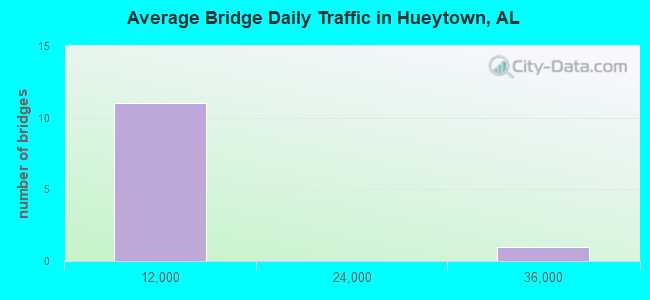
- 67,171Total average daily traffic
- 8,042Total average daily truck traffic
- National Bridge Inventory (NBI) Registered Bridges for Hueytown
- No street view available for this location
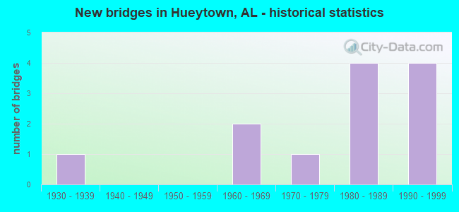
- New bridges - historical statistics
- 11930-1939
- 21960-1969
- 11970-1979
- 41980-1989
- 41990-1999
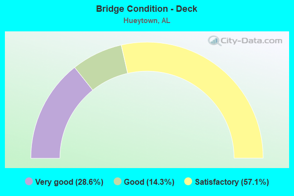
- Bridge Condition - Deck
- 28.6%Very good
- 14.3%Good
- 57.1%Satisfactory
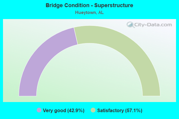
- Bridge Condition - Superstructure
- 42.9%Very good
- 57.1%Satisfactory
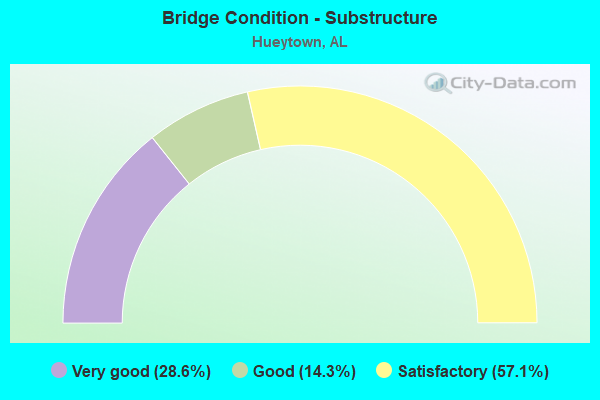
- Bridge Condition - Substructure
- 28.6%Very good
- 14.3%Good
- 57.1%Satisfactory
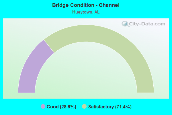
- Bridge Condition - Channel
- 28.6%Good
- 71.4%Satisfactory
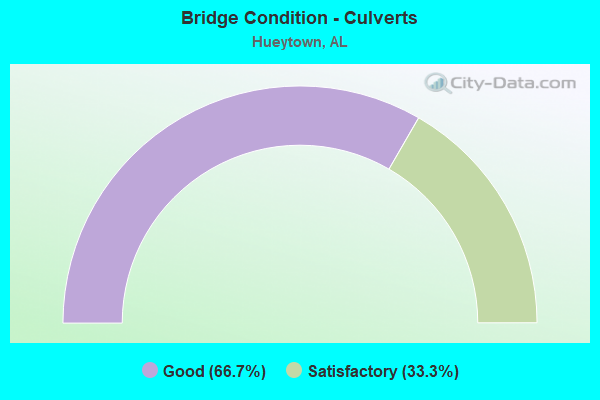
- Bridge Condition - Culverts
- 66.7%Good
- 33.3%Satisfactory
Find on map >> Show street view
Structure Number: 1996, Location: 2 MI SW OF HUEYTOWN (Lat: 33.431728, Lng: -87.013208), Route carried "on" structure: County highway 29, Year Built: 1939, Status: Open, Structure Length: 0.76m (2.49ft), Average Daily Traffic: 3,706 (year 2021), Truck Traffic: 15%, Average Future Daily Traffic: 4,325 (year 2041), Features Intersected: LICK CREEK, Facility Carried by Structure: VIRGINIA DRIVE
Minimum Vertical Clearance: 30+ m (98+ ft), Kilometerpoint: 0.010, Lanes on structure: 2, Owner: County Highway Agency, Approaching Roadway Width: 6.7m (22.0ft), Material/Design: Concrete continuous, Design/Construction: Slab, Number Of Spans In Main Unit: 2, Length of Maximum Span: 3.0m (9.8ft), Curb-To-Curb Width: 7.6m (24.9ft), Out-to-Out Width: 8.2m (26.9ft)
Condition: Deck: Satisfactory, Superstructure: Satisfactory, Substructure: Satisfactory, Channel: Satisfactory, Operating Rating: 32.7 metric tons, Method Used To Determine Operating Rating: Field evaluation and documented engineering judgment, Inventory Rating: 23.6 metric tons, Method Used To Determine Inventory Rating: Field evaluation and documented engineering judgment, Structural Evaluation: Equal to present minimum criteria, Deck Geometry: High priority of replacement, Waterway Adequacy: Equal to present minimum criteria, Approach Roadway Alignment: Better than present minimum criteria, Length Of Structure Improvement: 1.41m (4.63ft), Designated Inspection Frequency: Every 24 months, Inspection Date: October 2021, Bridge Improvement Cost: $252,000, Roadway Improvement Cost: $25,000, Total Project Cost: $277,000 ( Estimate for 2022), Deck Structure Type: Concrete Cast-file-Place, Wearing Surface/Protective System: Wearing Surface: Bituminous
Find on map >> Show street view
Structure Number: 847, Location: 3 MI S OF CONCORD (Lat: 33.435350, Lng: -87.050733), Route carried "on" structure: County highway 410, Year Built: 1964, Status: Open, Structure Length: 2.07m (6.79ft), Average Daily Traffic: 5,400 (year 2021), Truck Traffic: 15%, Average Future Daily Traffic: 7,525 (year 2041), Features Intersected: LICK CREEK, Facility Carried by Structure: 15TH ST RD HUEYTWN
Minimum Vertical Clearance: 30+ m (98+ ft), Kilometerpoint: 0.999, Lanes on structure: 2, Owner: County Highway Agency, Approaching Roadway Width: 7.9m (25.9ft), Material/Design: Concrete, Design/Construction: Channel Beam, Number Of Spans In Main Unit: 2, Length of Maximum Span: 9.7m (31.8ft), Curb or Sidewalk Widths: Left: 0.4m (1.3ft), Right: 0.4m (1.3ft), Curb-To-Curb Width: 8.4m (27.6ft), Out-to-Out Width: 9.3m (30.5ft)
Condition: Deck: Satisfactory, Superstructure: Satisfactory, Substructure: Satisfactory, Channel: Satisfactory, Operating Rating: 32.7 metric tons, Method Used To Determine Operating Rating: Field evaluation and documented engineering judgment, Inventory Rating: 23.6 metric tons, Method Used To Determine Inventory Rating: Field evaluation and documented engineering judgment, Structural Evaluation: Somewhat better than minimum adequacy, Deck Geometry: High priority of replacement, Waterway Adequacy: Equal to present minimum criteria, Approach Roadway Alignment: Better than present minimum criteria, Length Of Structure Improvement: 2.84m (9.32ft), Designated Inspection Frequency: Every 24 months, Inspection Date: Febuary 2021, Bridge Improvement Cost: $584,000, Roadway Improvement Cost: $58,000, Total Project Cost: $642,000 ( Estimate for 2022), Deck Structure Type: Concrete Precast Panels, Wearing Surface/Protective System: Wearing Surface: Bituminous
Find on map >> Show street view
Structure Number: 8932, Location: HUEYTOWN (Lat: 33.458217, Lng: -86.980717), Route carried "on" structure: County highway 410, Year Built: 1965, Status: Open, Structure Length: 3.11m (10.20ft), Average Daily Traffic: 8,180 (year 2021), Truck Traffic: 10%, Average Future Daily Traffic: 11,550 (year 2041), Design Load: HS 20, Features Intersected: USSC RR, Facility Carried by Structure: FOREST ROAD
Minimum Vertical Clearance: 30+ m (98+ ft), Kilometerpoint: 0.010, Lanes on structure: 2, Owner: County Highway Agency, Approaching Roadway Width: 7.4m (24.3ft), Material/Design: Concrete, Design/Construction: Channel Beam, Number Of Spans In Main Unit: 3, Length of Maximum Span: 9.7m (31.8ft), Curb or Sidewalk Widths: Left: 0.3m (1.0ft), Right: 0.3m (1.0ft), Curb-To-Curb Width: 7.9m (25.9ft), Out-to-Out Width: 8.5m (27.9ft)
Condition: Deck: Satisfactory, Superstructure: Satisfactory, Substructure: Satisfactory, Operating Rating: 40.4 metric tons, Method Used To Determine Operating Rating: Load Factor (LF), Inventory Rating: 24.0 metric tons, Method Used To Determine Inventory Rating: Load Factor (LF), Structural Evaluation: Somewhat better than minimum adequacy, Deck Geometry: High priority of replacement, Underclear: Somewhat better than minimum adequacy, Approach Roadway Alignment: Equal to present minimum criteria, Length Of Structure Improvement: 3.96m (12.99ft), Designated Inspection Frequency: Every 24 months, Inspection Date: September 2021, Bridge Improvement Cost: $733,000, Roadway Improvement Cost: $73,000, Total Project Cost: $806,000 ( Estimate for 2022), Deck Structure Type: Concrete Precast Panels, Wearing Surface/Protective System: Wearing Surface: Bituminous
Find on map >> Show street view
Structure Number: 12068, Location: VIRGIANA MINES (Lat: 33.405422, Lng: -87.048586), Route carried "on" structure: County highway 408, Year Built: 1978, Status: Open, Structure Length: 0.68m (2.23ft), Average Daily Traffic: 720 (year 2020), Truck Traffic: 2%, Average Future Daily Traffic: 900 (year 2040), Design Load: HS 20, Features Intersected: BLACK BRANCH, Facility Carried by Structure: VIRGINIA LANE
Minimum Vertical Clearance: 30+ m (98+ ft), Kilometerpoint: 0.010, Lanes on structure: 2, Owner: County Highway Agency, Approaching Roadway Width: 6.5m (21.3ft), Material/Design: Concrete, Design/Construction: Culvert, Number Of Spans In Main Unit: 2, Length of Maximum Span: 3.0m (9.8ft)
Condition: Channel: Satisfactory, Culverts: Good, Operating Rating: 86.7 metric tons, Method Used To Determine Operating Rating: Load Factor (LF), Inventory Rating: 52.1 metric tons, Method Used To Determine Inventory Rating: Load Factor (LF), Structural Evaluation: Better than present minimum criteria, Waterway Adequacy: Equal to present minimum criteria, Approach Roadway Alignment: Better than present minimum criteria, Length Of Structure Improvement: 1.31m (4.30ft), Designated Inspection Frequency: Every 24 months, Inspection Date: May 2020, Bridge Improvement Cost: $332,000, Roadway Improvement Cost: $33,000, Total Project Cost: $365,000 ( Estimate for 2022)
Find on map >> Show street view
Structure Number: 12311, Location: I59 * JAY BIRD RD (Lat: 33.455833, Lng: -86.958333), Route carried "on" structure: Interstate 20, Year Built: 1980, Status: Open, Structure Length: 11.13m (36.52ft), Average Daily Traffic: 30,650 (year 2021), Truck Traffic: 14%, Average Future Daily Traffic: 37,920 (year 2041), Design Load: HS 20, Features Intersected: JAY BIRD ROAD
Minimum Vertical Clearance: 7.56m (24.80ft), Kilometerpoint: 186.241, Lanes on structure: 2, Lanes under structure: 4, Base Highway Network: Yes, Owner: State Highway Agency, Approaching Roadway Width: 13.4m (44.0ft), Skew: 4 degrees, Material/Design: Steel continuous, Design/Construction: Stringer/Multi-beam, Number Of Spans In Main Unit: 3, Length of Maximum Span: 47.9m (157.2ft), Curb-To-Curb Width: 12.0m (39.4ft), Out-to-Out Width: 13.3m (43.6ft)
Condition: Deck: Satisfactory, Superstructure: Satisfactory, Substructure: Satisfactory, Operating Rating: 68.8 metric tons, Method Used To Determine Operating Rating: Load Factor (LF), Inventory Rating: 41.2 metric tons, Method Used To Determine Inventory Rating: Load Factor (LF), Structural Evaluation: Equal to present minimum criteria, Deck Geometry: Equal to present minimum criteria, Underclear: Better than present minimum criteria, Approach Roadway Alignment: Equal to present desirable criteria, Length Of Structure Improvement: 12.02m (39.44ft), Designated Inspection Frequency: Every 24 months, Inspection Date: July 2021, Bridge Improvement Cost: $3,543,000, Roadway Improvement Cost: $354,000, Total Project Cost: $3,897,000 ( Estimate for 2022), Deck Structure Type: Concrete Cast-file-Place
Find on map >> Show street view
Structure Number: 12848, Location: 2.8 MI N JOHNS RD ADGER (Lat: 33.416372, Lng: -87.085083), Route carried "on" structure: County highway 412, Year Built: 1982, Status: Open, Structure Length: 0.68m (2.23ft), Average Daily Traffic: 142 (year 2021), Truck Traffic: 1%, Average Future Daily Traffic: 220 (year 2041), Design Load: HS 20, Features Intersected: JOHNSON BRANCH, Facility Carried by Structure: VALLEY FORD ROAD
Minimum Vertical Clearance: 30+ m (98+ ft), Kilometerpoint: 0.010, Lanes on structure: 2, Owner: County Highway Agency, Approaching Roadway Width: 5.5m (18.0ft), Material/Design: Concrete, Design/Construction: Culvert, Number Of Spans In Main Unit: 2, Length of Maximum Span: 3.0m (9.8ft), Curb-To-Curb Width: 7.3m (24.0ft), Out-to-Out Width: 7.8m (25.6ft)
Condition: Channel: Satisfactory, Culverts: Satisfactory, Operating Rating: 60.4 metric tons, Method Used To Determine Operating Rating: Load Factor (LF), Inventory Rating: 36.2 metric tons, Method Used To Determine Inventory Rating: Load Factor (LF), Structural Evaluation: Equal to present minimum criteria, Deck Geometry: Somewhat better than minimum adequacy, Waterway Adequacy: Equal to present minimum criteria, Approach Roadway Alignment: Equal to present minimum criteria, Length Of Structure Improvement: 1.31m (4.30ft), Designated Inspection Frequency: Every 24 months, Inspection Date: August 2021, Bridge Improvement Cost: $226,000, Roadway Improvement Cost: $23,000, Total Project Cost: $249,000 ( Estimate for 2022)
Find on map >> Show street view
Structure Number: 16641, Location: KNIGHT AVE * BIRM SOU RR (Lat: 33.458389, Lng: -86.979833), Route carried "on" structure: City street , Year Built: 1999, Status: Open, Structure Length: 3.26m (10.70ft), Average Daily Traffic: 1,200 (year 2020), Truck Traffic: 1%, Average Future Daily Traffic: 1,680 (year 2040), Design Load: HS 20, Features Intersected: BIRMINGHAM SOU RR, Facility Carried by Structure: KNIGHT AVENUE
Minimum Vertical Clearance: 7.56m (24.80ft), Kilometerpoint: 0.240, Lanes on structure: 2, Owner: City or Municipal Highway Agency, Approaching Roadway Width: 9.1m (29.9ft), Material/Design: Prestressed concrete, Design/Construction: Box Beam or Girders - Multiple, Number Of Spans In Main Unit: 1, Number Of Approach Spans: 2, Length of Maximum Span: 19.2m (63.0ft), Curb-To-Curb Width: 9.0m (29.5ft), Out-to-Out Width: 9.8m (32.2ft)
Condition: Deck: Good, Superstructure: Very good, Substructure: Good, Operating Rating: 63.7 metric tons, Method Used To Determine Operating Rating: Load Factor (LF), Inventory Rating: 28.8 metric tons, Method Used To Determine Inventory Rating: Load Factor (LF), Structural Evaluation: Better than present minimum criteria, Deck Geometry: Somewhat better than minimum adequacy, Underclear: Equal to present minimum criteria, Approach Roadway Alignment: Equal to present minimum criteria, Length Of Structure Improvement: 4.13m (13.55ft), Designated Inspection Frequency: Every 24 months, Inspection Date: November 2020, Bridge Improvement Cost: $907,000, Roadway Improvement Cost: $91,000, Total Project Cost: $998,000 ( Estimate for 2022), Deck Structure Type: Concrete Precast Panels
Find on map >> Show street view
Structure Number: 17062, Location: 0.75MI NE MUD CRK RD (Lat: 33.386428, Lng: -87.080533), Route carried "on" structure: County highway 411, Year Built: 1997, Status: Open, Structure Length: 6.28m (20.60ft), Average Daily Traffic: 5,082 (year 2022), Truck Traffic: 5%, Average Future Daily Traffic: 8,025 (year 2042), Design Load: HS 20, Features Intersected: BLUE CREEK, Facility Carried by Structure: BESSEMER-JOHNS RD
Minimum Vertical Clearance: 30+ m (98+ ft), Kilometerpoint: 0.010, Lanes on structure: 2, Owner: County Highway Agency, Approaching Roadway Width: 8.5m (27.9ft), Skew: 3 degrees, Material/Design: Prestressed concrete, Design/Construction: Stringer/Multi-beam, Number Of Spans In Main Unit: 1, Number Of Approach Spans: 2, Length of Maximum Span: 30.5m (100.1ft), Curb-To-Curb Width: 12.1m (39.7ft), Out-to-Out Width: 13.0m (42.7ft)
Condition: Deck: Very good, Superstructure: Very good, Substructure: Very good, Channel: Satisfactory, Operating Rating: 60.9 metric tons, Method Used To Determine Operating Rating: Load Factor (LF), Inventory Rating: 37.5 metric tons, Method Used To Determine Inventory Rating: Load Factor (LF), Structural Evaluation: Equal to present desirable criteria, Deck Geometry: Somewhat better than minimum adequacy, Waterway Adequacy: Equal to present desirable criteria, Approach Roadway Alignment: Equal to present desirable criteria, Length Of Structure Improvement: 7.32m (24.02ft), Designated Inspection Frequency: Every 24 months, Inspection Date: Febuary 2022, Bridge Improvement Cost: $2,108,000, Roadway Improvement Cost: $211,000, Total Project Cost: $2,319,000 ( Estimate for 2022), Deck Structure Type: Concrete Cast-file-Place
Find on map >> Show street view
Structure Number: 1707, Location: 2 MI NE ADGER (Lat: 33.387603, Lng: -87.058739), Route carried "on" structure: County highway , Year Built: 1998, Status: Open, Structure Length: 6.29m (20.64ft), Average Daily Traffic: 4,756 (year 2021), Truck Traffic: 10%, Average Future Daily Traffic: 6,250 (year 2041), Design Load: HS 20, Features Intersected: VALLEY CREEK, Facility Carried by Structure: JOHNS ROAD
Minimum Vertical Clearance: 30+ m (98+ ft), Kilometerpoint: 0.010, Lanes on structure: 2, Owner: County Highway Agency, Approaching Roadway Width: 9.2m (30.2ft), Material/Design: Prestressed concrete, Design/Construction: Stringer/Multi-beam, Number Of Spans In Main Unit: 1, Number Of Approach Spans: 2, Length of Maximum Span: 30.8m (101.0ft), Curb-To-Curb Width: 12.2m (40.0ft), Out-to-Out Width: 13.0m (42.7ft)
Condition: Deck: Very good, Superstructure: Very good, Substructure: Very good, Channel: Good, Operating Rating: 66.4 metric tons, Method Used To Determine Operating Rating: Load Factor (LF), Inventory Rating: 40.9 metric tons, Method Used To Determine Inventory Rating: Load Factor (LF), Structural Evaluation: Equal to present desirable criteria, Deck Geometry: Equal to present minimum criteria, Waterway Adequacy: Equal to present desirable criteria, Approach Roadway Alignment: Equal to present desirable criteria, Length Of Structure Improvement: 7.33m (24.05ft), Designated Inspection Frequency: Every 24 months, Inspection Date: June 2021, Bridge Improvement Cost: $2,111,000, Roadway Improvement Cost: $211,000, Total Project Cost: $2,322,000 ( Estimate for 2022), Deck Structure Type: Concrete Cast-file-Place
Find on map >> Show street view
Structure Number: 17588, Location: 100' WEST VALLEY CREEK (Lat: 33.387564, Lng: -87.059889), Route carried "on" structure: County highway 36, Year Built: 1999, Status: Open, Structure Length: 0.69m (2.26ft), Average Daily Traffic: 4,935 (year 2021), Truck Traffic: 15%, Average Future Daily Traffic: 6,925 (year 2041), Design Load: HS 20, Features Intersected: VALLEY CREEK TRIBUTARY, Facility Carried by Structure: JOHNS ROAD
Minimum Vertical Clearance: 30+ m (98+ ft), Kilometerpoint: 0.010, Lanes on structure: 2, Owner: County Highway Agency, Approaching Roadway Width: 7.3m (24.0ft), Material/Design: Concrete, Design/Construction: Culvert, Number Of Spans In Main Unit: 2, Length of Maximum Span: 3.0m (9.8ft)
Condition: Channel: Good, Culverts: Good, Operating Rating: 88.9 metric tons, Method Used To Determine Operating Rating: Load Factor (LF), Inventory Rating: 88.9 metric tons, Method Used To Determine Inventory Rating: Load Factor (LF), Structural Evaluation: Better than present minimum criteria, Waterway Adequacy: Better than present minimum criteria, Approach Roadway Alignment: Better than present minimum criteria, Length Of Structure Improvement: 1.32m (4.33ft), Designated Inspection Frequency: Every 24 months, Inspection Date: August 2021, Bridge Improvement Cost: $1,069,000, Roadway Improvement Cost: $107,000, Total Project Cost: $1,176,000 ( Estimate for 2022)
Find on map >> Show street view
Structure Number: 1231, Location: I59 * JAY BIRD RD (Lat: 33.455833, Lng: -86.958333), Route carried "under" structure: County highway , Year Built: 1980, Structure Length: 0. m, Average Daily Traffic: 1,200 (year 2021), Truck Traffic: 3%, Features Intersected: JAY BIRD ROAD, Facility Carried by Structure: I - 20/59 SOUTH
Minimum Vertical Clearance: 7.04m (23.10ft), Kilometerpoint: 0.010, Lanes on structure: 2, Lanes under structure: 4, Material/Design: Steel continuous, Design/Construction: Stringer/Multi-beam, Length of Maximum Span: 47.9m (157.2ft)
Find on map >> Show street view
Structure Number: 12311, Location: I59 * JAY BIRD RD (Lat: 33.455833, Lng: -86.958333), Route carried "under" structure: County highway , Year Built: 1980, Structure Length: 0. m, Average Daily Traffic: 1,200 (year 2021), Truck Traffic: 3%, Features Intersected: JAY BIRD ROAD, Facility Carried by Structure: I - 20/59 NORTH
Minimum Vertical Clearance: 5.05m (16.57ft), Kilometerpoint: 0.100, Lanes on structure: 2, Lanes under structure: 4, Toll: Toll bridge, Material/Design: Steel continuous, Design/Construction: Stringer/Multi-beam, Length of Maximum Span: 47.9m (157.2ft)