Bridge Statistics for Humboldt, Kansas (KS)
Condition, Traffic, Stress, Structural Evaluation, Project Costs
- National Bridge Inventory (NBI) Statistics
- 30Number of bridges
- 361ft / 110mTotal length
- $2,155,000Total costs
- 56,715Total average daily traffic
- 14,552Total average daily truck traffic
- National Bridge Inventory (NBI) Registered Bridges for Humboldt
- No street view available for this location
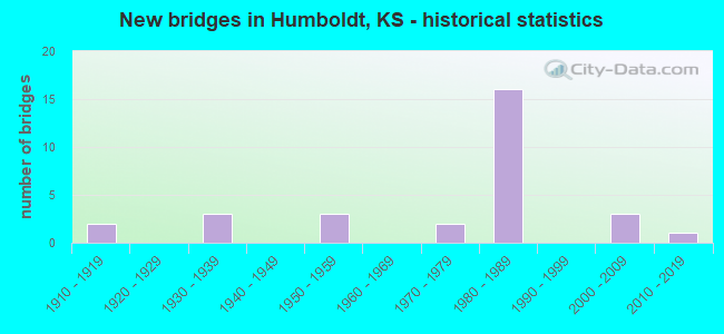
- New bridges - historical statistics
- 21910-1919
- 31930-1939
- 31950-1959
- 21970-1979
- 161980-1989
- 32000-2009
- 12010-2019
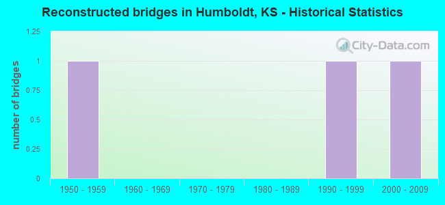
- Reconstructed bridges - Historical Statistics
- 11950-1959
- 01960-1969
- 01970-1979
- 01980-1989
- 11990-1999
- 12000-2009
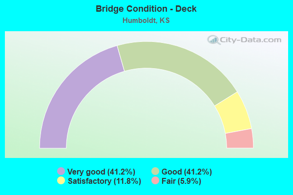
- Bridge Condition - Deck
- 41.2%Very good
- 41.2%Good
- 11.8%Satisfactory
- 5.9%Fair
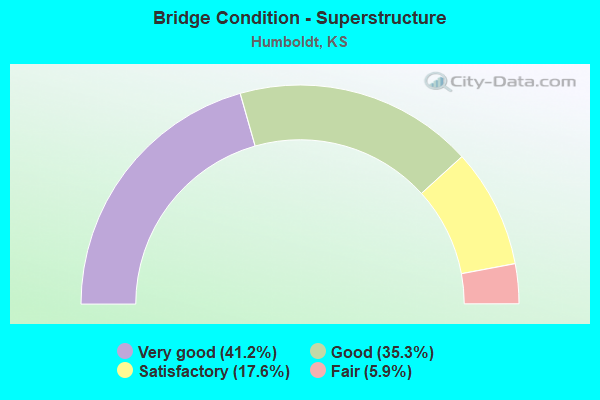
- Bridge Condition - Superstructure
- 41.2%Very good
- 35.3%Good
- 17.6%Satisfactory
- 5.9%Fair
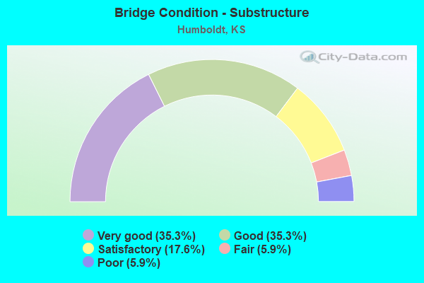
- Bridge Condition - Substructure
- 35.3%Very good
- 35.3%Good
- 17.6%Satisfactory
- 5.9%Fair
- 5.9%Poor
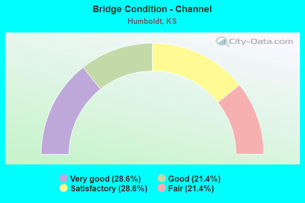
- Bridge Condition - Channel
- 28.6%Very good
- 21.4%Good
- 28.6%Satisfactory
- 21.4%Fair
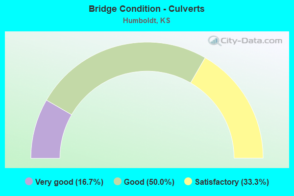
- Bridge Condition - Culverts
- 16.7%Very good
- 50.0%Good
- 33.3%Satisfactory
Find on map >> Show street view
Structure Number: 1004, Location: 2.0W 1.7N OF HUMBOLDT (Lat: 37.842819, Lng: -95.482528), Route carried "on" structure: County highway 1, Year Built: 1930, Status: Posted for load, Structure Length: 0.93m (3.05ft), Average Daily Traffic: 296 (year 2006), Truck Traffic: 11%, Average Future Daily Traffic: 368 (year 2039), Features Intersected: BRANCH OF NEOSHO RIVER
Minimum Vertical Clearance: 30.47m (99.97ft), Kilometerpoint: 14.810, Lanes on structure: 2, Owner: County Highway Agency, Approaching Roadway Width: 8.1m (26.6ft), Material/Design: Concrete, Design/Construction: Culvert, Number Of Spans In Main Unit: 2, Number Of Approach Spans: 1, Length of Maximum Span: 2.4m (7.9ft), Curb-To-Curb Width: 7.8m (25.6ft), Out-to-Out Width: 8.5m (27.9ft)
Condition: Channel: Satisfactory, Culverts: Good, Operating Rating: 32.4 metric tons, Method Used To Determine Operating Rating: Load Factor (LF), Inventory Rating: 23.6 metric tons, Method Used To Determine Inventory Rating: Load Factor (LF), Structural Evaluation: Equal to present minimum criteria, Deck Geometry: Somewhat better than minimum adequacy, Waterway Adequacy: Somewhat better than minimum adequacy, Approach Roadway Alignment: Equal to present desirable criteria, Designated Inspection Frequency: Every 24 months, Inspection Date: Febuary 2020, Other Special Inspection Date: August 2021
Find on map >> Show street view
Structure Number: 1006, Location: 0.2W OF HUMBOLDT (Lat: 37.811086, Lng: -95.450289), Route carried "on" structure: County highway 2, Year Built: 2000, Status: Open, Structure Length: 7.83m (25.69ft), Average Daily Traffic: 1,098 (year 2006), Truck Traffic: 11%, Average Future Daily Traffic: 1,136 (year 2040), Design Load: HS 20, Features Intersected: RELIEF OF NEOSHO RIVER
Minimum Vertical Clearance: 30.47m (99.97ft), Kilometerpoint: 4.829, Lanes on structure: 2, Owner: County Highway Agency, Approaching Roadway Width: 9.2m (30.2ft), Material/Design: Concrete continuous, Design/Construction: Slab, Number Of Spans In Main Unit: 6, Length of Maximum Span: 14.0m (45.9ft), Curb-To-Curb Width: 9.2m (30.2ft), Out-to-Out Width: 9.8m (32.2ft)
Condition: Deck: Very good, Superstructure: Very good, Substructure: Very good, Channel: Very good, Operating Rating: 41.5 metric tons, Method Used To Determine Operating Rating: Load Factor (LF), Inventory Rating: 32.0 metric tons, Method Used To Determine Inventory Rating: Load Factor (LF), Structural Evaluation: Better than present minimum criteria, Deck Geometry: Somewhat better than minimum adequacy, Waterway Adequacy: Equal to present desirable criteria, Approach Roadway Alignment: Better than present minimum criteria, Designated Inspection Frequency: Every 24 months, Inspection Date: April 2020, Deck Structure Type: Concrete Cast-file-Place, Wearing Surface/Protective System: Deck Protection: Epoxy Coated Reinforcing
Find on map >> Show street view
Structure Number: 1037, Location: 2.8W 0.2N OF HUMBOLDT (Lat: 37.820283, Lng: -95.498528), Route carried "on" structure: County highway 1131, Year Built: 1978, Status: Open, Structure Length: 1.01m (3.31ft), Average Daily Traffic: 124 (year 2006), Truck Traffic: 11%, Average Future Daily Traffic: 124 (year 2041), Design Load: H 20, Features Intersected: BLOODY RUN CREEK
Minimum Vertical Clearance: 30.47m (99.97ft), Kilometerpoint: 2.093, Lanes on structure: 2, Owner: County Highway Agency, Approaching Roadway Width: 9.1m (29.9ft), Material/Design: Concrete, Design/Construction: Culvert, Number Of Spans In Main Unit: 2, Length of Maximum Span: 4.9m (16.1ft), Curb or Sidewalk Widths: Left: 0.3m (1.0ft), Right: 0.3m (1.0ft), Curb-To-Curb Width: 9.1m (29.9ft), Out-to-Out Width: 9.7m (31.8ft)
Condition: Channel: Satisfactory, Culverts: Satisfactory, Operating Rating: 30.0 metric tons, Method Used To Determine Operating Rating: Load Factor (LF), Inventory Rating: 18.0 metric tons, Method Used To Determine Inventory Rating: Load Factor (LF), Structural Evaluation: Somewhat better than minimum adequacy, Deck Geometry: Equal to present minimum criteria, Waterway Adequacy: Equal to present minimum criteria, Approach Roadway Alignment: Equal to present desirable criteria, Designated Inspection Frequency: Every 24 months, Inspection Date: Febuary 2020
Find on map >> Show street view
Structure Number: 10395, Location: S. EDGE OF HUMBOLDT (Lat: 37.795819, Lng: -95.429028), Route carried "on" structure: County highway 1148, Year Built: 2001, Status: Open, Structure Length: 6.58m (21.59ft), Average Daily Traffic: 945 (year 2006), Truck Traffic: 35%, Average Future Daily Traffic: 1,050 (year 2040), Design Load: HS 20, Features Intersected: COAL CREEK
Minimum Vertical Clearance: 30.47m (99.97ft), Kilometerpoint: 9.691, Lanes on structure: 2, Owner: County Highway Agency, Approaching Roadway Width: 9.2m (30.2ft), Skew: 3 degrees, Material/Design: Steel continuous, Design/Construction: Stringer/Multi-beam, Number Of Spans In Main Unit: 3, Length of Maximum Span: 25.0m (82.0ft), Curb or Sidewalk Widths: Left: 0.3m (1.0ft), Right: 0.3m (1.0ft), Curb-To-Curb Width: 9.2m (30.2ft), Out-to-Out Width: 9.8m (32.2ft)
Condition: Deck: Very good, Superstructure: Very good, Substructure: Very good, Channel: Very good, Operating Rating: 46.7 metric tons, Method Used To Determine Operating Rating: Load Factor (LF), Inventory Rating: 27.9 metric tons, Method Used To Determine Inventory Rating: Load Factor (LF), Structural Evaluation: Better than present minimum criteria, Deck Geometry: Equal to present minimum criteria, Waterway Adequacy: Equal to present desirable criteria, Approach Roadway Alignment: Equal to present desirable criteria, Designated Inspection Frequency: Every 24 months, Inspection Date: April 2020, Deck Structure Type: Concrete Cast-file-Place, Wearing Surface/Protective System: Deck Protection: Epoxy Coated Reinforcing
Find on map >> Show street view
Structure Number: 10664, Location: 1.4S OF HUMBOLDT (Lat: 37.788297, Lng: -95.434769), Route carried "on" structure: County highway 2096, Year Built: 1953, Year Reconstructed: 2007, Status: Open, Structure Length: 6.80m (22.31ft), Average Daily Traffic: 2,658 (year 2006), Truck Traffic: 20%, Average Future Daily Traffic: 2,658 (year 2040), Design Load: H 20, Features Intersected: COAL CREEK
Minimum Vertical Clearance: 30.47m (99.97ft), Kilometerpoint: 6.230, Lanes on structure: 2, Owner: County Highway Agency, Approaching Roadway Width: 7.9m (25.9ft), Material/Design: Concrete continuous, Design/Construction: Tee Beam, Number Of Spans In Main Unit: 3, Length of Maximum Span: 27.7m (90.9ft), Curb or Sidewalk Widths: Left: 0.8m (2.6ft), Right: 0.8m (2.6ft), Curb-To-Curb Width: 7.9m (25.9ft), Out-to-Out Width: 9.4m (30.8ft)
Condition: Deck: Good, Superstructure: Good, Substructure: Good, Channel: Very good, Operating Rating: 20.9 metric tons, Method Used To Determine Operating Rating: Load Testing, Inventory Rating: 18.1 metric tons, Method Used To Determine Inventory Rating: Load Testing, Structural Evaluation: Somewhat better than minimum adequacy, Deck Geometry: High priority of corrective action, Waterway Adequacy: Equal to present desirable criteria, Approach Roadway Alignment: Equal to present desirable criteria, Length Of Structure Improvement: 6.83m (22.41ft), Designated Inspection Frequency: Every 24 months, Inspection Date: April 2020, Other Special Inspection Date: August 2021, Bridge Improvement Cost: $395,000, Roadway Improvement Cost: $35,000, Total Project Cost: $575,000, Deck Structure Type: Concrete Cast-file-Place
Find on map >> Show street view
Structure Number: 10666, Location: 1.2S OF HUMBOLDT (Lat: 37.794361, Lng: -95.435322), Route carried "on" structure: County highway 2096, Year Built: 1953, Status: Open, Structure Length: 4.51m (14.80ft), Average Daily Traffic: 2,304 (year 2006), Truck Traffic: 10%, Average Future Daily Traffic: 2,318 (year 2040), Design Load: H 20, Features Intersected: MONARCH OVERPASS
Minimum Vertical Clearance: 30.47m (99.97ft), Kilometerpoint: 6.906, Lanes on structure: 2, Owner: County Highway Agency, Approaching Roadway Width: 7.9m (25.9ft), Skew: 1 degrees, Material/Design: Concrete continuous, Design/Construction: Slab, Number Of Spans In Main Unit: 4, Length of Maximum Span: 12.2m (40.0ft), Curb or Sidewalk Widths: Left: 0.8m (2.6ft), Right: 0.8m (2.6ft), Curb-To-Curb Width: 7.9m (25.9ft), Out-to-Out Width: 9.4m (30.8ft)
Condition: Deck: Good, Superstructure: Good, Substructure: Very good, Operating Rating: 27.0 metric tons, Method Used To Determine Operating Rating: Load Factor (LF), Inventory Rating: 19.8 metric tons, Method Used To Determine Inventory Rating: Load Factor (LF), Structural Evaluation: Somewhat better than minimum adequacy, Deck Geometry: High priority of corrective action, Approach Roadway Alignment: Equal to present desirable criteria, Length Of Structure Improvement: 4.48m (14.70ft), Designated Inspection Frequency: Every 24 months, Inspection Date: April 2020, Other Special Inspection Date: August 2021, Bridge Improvement Cost: $203,000, Roadway Improvement Cost: $20,000, Total Project Cost: $304,000, Deck Structure Type: Concrete Cast-file-Place
Find on map >> Show street view
Structure Number: 10668, Location: 1.0S OF HUMBOLDT (Lat: 37.797242, Lng: -95.435333), Route carried "on" structure: County highway 2096, Year Built: 1953, Status: Open, Structure Length: 6.89m (22.60ft), Average Daily Traffic: 2,304 (year 2006), Truck Traffic: 10%, Average Future Daily Traffic: 2,318 (year 2040), Design Load: H 20, Features Intersected: MONARCH OVERPASS
Minimum Vertical Clearance: 30.47m (99.97ft), Kilometerpoint: 7.228, Lanes on structure: 2, Owner: County Highway Agency, Approaching Roadway Width: 7.9m (25.9ft), Material/Design: Concrete continuous, Design/Construction: Slab, Number Of Spans In Main Unit: 7, Length of Maximum Span: 10.4m (34.1ft), Curb or Sidewalk Widths: Left: 0.7m (2.3ft), Right: 0.7m (2.3ft), Curb-To-Curb Width: 7.9m (25.9ft), Out-to-Out Width: 9.4m (30.8ft)
Condition: Deck: Good, Superstructure: Satisfactory, Substructure: Satisfactory, Operating Rating: 27.0 metric tons, Method Used To Determine Operating Rating: Load Factor (LF), Inventory Rating: 19.8 metric tons, Method Used To Determine Inventory Rating: Load Factor (LF), Structural Evaluation: Somewhat better than minimum adequacy, Deck Geometry: High priority of corrective action, Approach Roadway Alignment: Equal to present desirable criteria, Length Of Structure Improvement: 6.89m (22.60ft), Designated Inspection Frequency: Every 24 months, Inspection Date: April 2020, Other Special Inspection Date: August 2021, Bridge Improvement Cost: $312,000, Roadway Improvement Cost: $31,000, Total Project Cost: $468,000, Deck Structure Type: Concrete Cast-file-Place
Find on map >> Show street view
Structure Number: 1067, Location: 0.8N OF HUMBOLDT (Lat: 37.833306, Lng: -95.436817), Route carried "on" structure: County highway 2096, Year Built: 1910, Year Reconstructed: 1950, Status: Posted for load, Structure Length: 1.10m (3.61ft), Average Daily Traffic: 1,922 (year 2006), Truck Traffic: 11%, Average Future Daily Traffic: 1,922 (year 2040), Design Load: HS 15, Features Intersected: TRIB. TO NEOSHO RIVER
Minimum Vertical Clearance: 30.47m (99.97ft), Kilometerpoint: 9.659, Lanes on structure: 2, Owner: County Highway Agency, Approaching Roadway Width: 6.7m (22.0ft), Material/Design: Masonry, Design/Construction: Arch - Deck, Number Of Spans In Main Unit: 3, Length of Maximum Span: 3.0m (9.8ft), Curb-To-Curb Width: 12.3m (40.4ft), Out-to-Out Width: 12.5m (41.0ft)
Condition: Deck: Good, Superstructure: Fair, Substructure: Fair, Channel: Satisfactory, Operating Rating: 16.6 metric tons, Method Used To Determine Operating Rating: Load Factor (LF), Inventory Rating: 9.9 metric tons, Method Used To Determine Inventory Rating: Load Factor (LF), Structural Evaluation: High priority of corrective action, Deck Geometry: Better than present minimum criteria, Waterway Adequacy: Equal to present minimum criteria, Approach Roadway Alignment: Equal to present desirable criteria, Bridge Posting: Required (Relationship of Operating Rating to Maximum Legal Load: 0.1 - 9.9% below), Length Of Structure Improvement: 3.41m (11.19ft), Designated Inspection Frequency: Every 24 months, Inspection Date: July 2020, Bridge Improvement Cost: $196,000, Roadway Improvement Cost: $30,000, Total Project Cost: $339,000, Deck Structure Type: Other, Wearing Surface/Protective System: Wearing Surface: Bituminous
Find on map >> Show street view
Structure Number: 11019005984, Location: 3.5W 1.0N OF HUMBOLDT (Lat: 37.828567, Lng: -95.500844), Route carried "on" structure: County highway , Year Built: 1930, Status: Open, Structure Length: 1.16m (3.81ft), Average Daily Traffic: 40 (year 2006), Average Future Daily Traffic: 40 (year 2039), Features Intersected: STREAM,LWC, Facility Carried by Structure: 400 Rd 2.0-O.4
Minimum Vertical Clearance: 30.47m (99.97ft), Kilometerpoint: 0.000, Lanes on structure: 2, Owner: County Highway Agency, Approaching Roadway Width: 6.0m (19.7ft), Material/Design: Concrete continuous, Design/Construction: Slab, Number Of Spans In Main Unit: 2, Length of Maximum Span: 3.0m (9.8ft), Curb-To-Curb Width: 7.3m (24.0ft), Out-to-Out Width: 7.3m (24.0ft)
Condition: Deck: Satisfactory, Superstructure: Satisfactory, Substructure: Satisfactory, Channel: Fair, Operating Rating: 27.0 metric tons, Method Used To Determine Operating Rating: Load Testing, Inventory Rating: 19.8 metric tons, Method Used To Determine Inventory Rating: Load Testing, Structural Evaluation: Somewhat better than minimum adequacy, Deck Geometry: Equal to present minimum criteria, Waterway Adequacy: High priority of corrective action, Approach Roadway Alignment: Equal to present minimum criteria, Length Of Structure Improvement: 2.16m (7.09ft), Designated Inspection Frequency: Every 24 months, Inspection Date: Febuary 2020, Bridge Improvement Cost: $33,000, Roadway Improvement Cost: $3,000, Total Project Cost: $50,000, Deck Structure Type: Concrete Cast-file-Place
Find on map >> Show street view
Structure Number: 11019706011, Location: 3.4W OF HUMBOLDT (Lat: 37.811389, Lng: -95.492106), Route carried "on" structure: County highway 129, Year Built: 2015, Status: Open, Structure Length: 4.95m (16.24ft), Average Daily Traffic: 30 (year 2013), Average Future Daily Traffic: 35 (year 2039), Design Load: HL 93, Features Intersected: OWL CREEK, Facility Carried by Structure: LOCAL RD. 2.8-P.6
Minimum Vertical Clearance: 30.47m (99.97ft), Kilometerpoint: 0.000, Lanes on structure: 2, Owner: County Highway Agency, Approaching Roadway Width: 9.7m (31.8ft), Material/Design: Concrete continuous, Design/Construction: Slab, Number Of Spans In Main Unit: 3, Length of Maximum Span: 19.5m (64.0ft), Curb-To-Curb Width: 9.8m (32.2ft), Out-to-Out Width: 10.4m (34.1ft)
Condition: Deck: Very good, Superstructure: Very good, Substructure: Very good, Channel: Very good, Operating Rating: 81.6 metric tons, Method Used To Determine Operating Rating: Load Factor (LF), Inventory Rating: 49.0 metric tons, Method Used To Determine Inventory Rating: Load Factor (LF), Structural Evaluation: Equal to present desirable criteria, Deck Geometry: Equal to present desirable criteria, Waterway Adequacy: Equal to present desirable criteria, Approach Roadway Alignment: Equal to present desirable criteria, Designated Inspection Frequency: Every 24 months, Inspection Date: Febuary 2020, Deck Structure Type: Concrete Cast-file-Place, Wearing Surface/Protective System: Wearing Surface: Monolithic Concrete
Find on map >> Show street view
Structure Number: 1102130596, Location: 2.0N 2.0W OF HUMBOLDT (Lat: 37.849336, Lng: -95.477669), Route carried "on" structure: County highway , Year Built: 1918, Year Reconstructed: 1997, Status: Open, Structure Length: 0.73m (2.40ft), Average Daily Traffic: 5 (year 2006), Average Future Daily Traffic: 5 (year 2039), Features Intersected: STREAM, Facility Carried by Structure: Iowa Rd 3.3-N.0
Minimum Vertical Clearance: 30.47m (99.97ft), Kilometerpoint: 0.000, Lanes on structure: 2, Owner: County Highway Agency, Approaching Roadway Width: 5.4m (17.7ft), Material/Design: Steel, Design/Construction: Culvert, Number Of Spans In Main Unit: 5, Length of Maximum Span: 1.2m (3.9ft), Curb-To-Curb Width: 5.8m (19.0ft), Out-to-Out Width: 5.8m (19.0ft)
Condition: Channel: Fair, Culverts: Satisfactory, Operating Rating: 67.8 metric tons, Method Used To Determine Operating Rating: Load Factor (LF), Inventory Rating: 40.6 metric tons, Method Used To Determine Inventory Rating: Load Factor (LF), Structural Evaluation: Equal to present minimum criteria, Deck Geometry: Meets minimum limits, Waterway Adequacy: High priority of corrective action, Approach Roadway Alignment: Somewhat better than minimum adequacy, Length Of Structure Improvement: 1.37m (4.49ft), Designated Inspection Frequency: Every 24 months, Inspection Date: Febuary 2020, Bridge Improvement Cost: $115,000, Roadway Improvement Cost: $25,000, Total Project Cost: $175,000
Find on map >> Show street view
Structure Number: 11029306088, Location: 4.3S 1.3E OF HUMBOLDT (Lat: 37.750861, Lng: -95.409519), Route carried "on" structure: County highway , Year Built: 1976, Status: Open, Structure Length: 1.32m (4.33ft), Average Daily Traffic: 60 (year 2006), Average Future Daily Traffic: 60 (year 2040), Design Load: H 20, Features Intersected: STREAM, Facility Carried by Structure: Arizona Rd 7.3-T.8
Minimum Vertical Clearance: 30.47m (99.97ft), Kilometerpoint: 0.000, Lanes on structure: 2, Owner: County Highway Agency, Approaching Roadway Width: 7.3m (24.0ft), Skew: 3 degrees, Material/Design: Concrete, Design/Construction: Culvert, Number Of Spans In Main Unit: 3, Length of Maximum Span: 4.2m (13.8ft), Curb-To-Curb Width: 7.3m (24.0ft), Out-to-Out Width: 7.9m (25.9ft)
Condition: Channel: Satisfactory, Culverts: Good, Operating Rating: 40.1 metric tons, Method Used To Determine Operating Rating: Load Factor (LF), Inventory Rating: 23.9 metric tons, Method Used To Determine Inventory Rating: Load Factor (LF), Structural Evaluation: Equal to present minimum criteria, Deck Geometry: Equal to present minimum criteria, Waterway Adequacy: Better than present minimum criteria, Approach Roadway Alignment: Equal to present desirable criteria, Designated Inspection Frequency: Every 24 months, Inspection Date: April 2020, Other Special Inspection Date: September 2019
Find on map >> Show street view
Structure Number: 11031006008, Location: 2.0E OF HUMBOLDT (Lat: 37.808156, Lng: -95.396731), Route carried "on" structure: County highway , Year Built: 1930, Status: Open, Structure Length: 0.98m (3.22ft), Average Daily Traffic: 30 (year 2006), Average Future Daily Traffic: 30 (year 2041), Features Intersected: STREAM,LWC, Facility Carried by Structure: 1600 St. 8.0-P.8
Minimum Vertical Clearance: 30.47m (99.97ft), Kilometerpoint: 0.000, Lanes on structure: 2, Owner: County Highway Agency, Approaching Roadway Width: 5.4m (17.7ft), Skew: 4 degrees, Material/Design: Concrete continuous, Design/Construction: Slab, Number Of Spans In Main Unit: 2, Length of Maximum Span: 4.3m (14.1ft), Curb-To-Curb Width: 5.2m (17.1ft), Out-to-Out Width: 5.5m (18.0ft)
Condition: Deck: Fair, Superstructure: Satisfactory, Substructure: Poor, Channel: Fair, Operating Rating: 27.0 metric tons, Method Used To Determine Operating Rating: Load Testing, Inventory Rating: 19.8 metric tons, Method Used To Determine Inventory Rating: Load Testing, Structural Evaluation: Meets minimum limits, Deck Geometry: High priority of corrective action, Waterway Adequacy: High priority of corrective action, Approach Roadway Alignment: High priority of corrective action, Length Of Structure Improvement: 2.44m (8.01ft), Designated Inspection Frequency: Every 24 months, Inspection Date: Febuary 2021, Bridge Improvement Cost: $35,000, Roadway Improvement Cost: $4,000, Total Project Cost: $53,000, Deck Structure Type: Concrete Cast-file-Place
Find on map >> Show street view
Structure Number: 1103190604, Location: 2.9E 1.5S OF HUMBOLDT (Lat: 37.791106, Lng: -95.380119), Route carried "on" structure: County highway , Year Built: 2005, Status: Open, Structure Length: 1.46m (4.79ft), Average Daily Traffic: 30 (year 2006), Average Future Daily Traffic: 35 (year 2040), Features Intersected: STREAM, Facility Carried by Structure: LOCAL RD 8.9-R.0
Minimum Vertical Clearance: 30.47m (99.97ft), Kilometerpoint: 0.000, Lanes on structure: 2, Owner: County Highway Agency, Approaching Roadway Width: 7.8m (25.6ft), Material/Design: Steel, Design/Construction: Culvert, Number Of Spans In Main Unit: 5, Length of Maximum Span: 1.2m (3.9ft), Curb-To-Curb Width: 8.5m (27.9ft), Out-to-Out Width: 8.5m (27.9ft)
Condition: Channel: Good, Culverts: Very good, Operating Rating: 23.8 metric tons, Method Used To Determine Operating Rating: Load Factor (LF), Inventory Rating: 14.2 metric tons, Method Used To Determine Inventory Rating: Load Factor (LF), Structural Evaluation: Meets minimum limits, Deck Geometry: Better than present minimum criteria, Waterway Adequacy: Equal to present minimum criteria, Approach Roadway Alignment: Equal to present minimum criteria, Length Of Structure Improvement: 4.57m (14.99ft), Designated Inspection Frequency: Every 24 months, Inspection Date: April 2020, Bridge Improvement Cost: $127,000, Roadway Improvement Cost: $13,000, Total Project Cost: $191,000
Find on map >> Show street view
Structure Number: 999916900010341, Location: 5.50 MI NE NEOSHO COLN (Lat: 37.790833, Lng: -95.411389), Route carried "on" structure: County highway 1148, Year Built: 1980, Status: Open, Structure Length: 8.31m (27.26ft), Average Daily Traffic: 960 (year 2020), Truck Traffic: 4%, Average Future Daily Traffic: 6,806 (year 2041), Design Load: HS 20, Features Intersected: US169 HWY, Facility Carried by Structure: TANK ROAD
Minimum Vertical Clearance: 30.47m (99.97ft), Kilometerpoint: 7.730, Lanes on structure: 2, Lanes under structure: 2, Owner: State Highway Agency, Approaching Roadway Width: 7.3m (24.0ft), Material/Design: Prestressed concrete continuous, Design/Construction: Stringer/Multi-beam, Number Of Spans In Main Unit: 4, Length of Maximum Span: 27.4m (89.9ft), Curb-To-Curb Width: 13.4m (44.0ft), Out-to-Out Width: 14.0m (45.9ft)
Condition: Deck: Satisfactory, Superstructure: Good, Substructure: Satisfactory, Operating Rating: 65.3 metric tons, Method Used To Determine Operating Rating: Load Factor (LF), Inventory Rating: 29.0 metric tons, Method Used To Determine Inventory Rating: Load Factor (LF), Structural Evaluation: Equal to present minimum criteria, Deck Geometry: Superior to present desirable criteria, Underclear: Better than present minimum criteria, Approach Roadway Alignment: Meets minimum limits, Length Of Structure Improvement: 27.25m (89.40ft), Designated Inspection Frequency: Every 24 months, Inspection Date: Febuary 2021, Deck Structure Type: Concrete Cast-file-Place, Wearing Surface/Protective System: Wearing Surface: Low Slump Concrete
Find on map >> Show street view
Structure Number: 999916900010351, Location: 5.96 MI NE NEOSHO COLN (Lat: 37.797500, Lng: -95.411111), Route carried "on" structure: US 169, Year Built: 1980, Status: Open, Structure Length: 7.40m (24.28ft), Average Daily Traffic: 4,874 (year 2020), Truck Traffic: 29%, Average Future Daily Traffic: 7,243 (year 2041), Design Load: HS 20, Features Intersected: COAL CREEK
Minimum Vertical Clearance: 30.47m (99.97ft), Kilometerpoint: 9.580, Lanes on structure: 2, Base Highway Network: Yes, Owner: State Highway Agency, Approaching Roadway Width: 13.4m (44.0ft), Skew: 2 degrees, Material/Design: Prestressed concrete continuous, Design/Construction: Stringer/Multi-beam, Number Of Spans In Main Unit: 4, Length of Maximum Span: 18.4m (60.4ft), Curb-To-Curb Width: 13.4m (44.0ft), Out-to-Out Width: 14.2m (46.6ft)
Condition: Deck: Good, Superstructure: Very good, Substructure: Good, Channel: Good, Operating Rating: 66.2 metric tons, Method Used To Determine Operating Rating: Load Factor (LF), Inventory Rating: 38.1 metric tons, Method Used To Determine Inventory Rating: Load Factor (LF), Structural Evaluation: Better than present minimum criteria, Deck Geometry: Better than present minimum criteria, Waterway Adequacy: Better than present minimum criteria, Approach Roadway Alignment: Equal to present desirable criteria, Length Of Structure Improvement: 24.27m (79.63ft), Designated Inspection Frequency: Every 24 months, Inspection Date: Febuary 2021, Deck Structure Type: Concrete Cast-file-Place, Wearing Surface/Protective System: Wearing Surface: Epoxy Overlay
Find on map >> Show street view
Structure Number: 999916900010361, Location: 6.51 MI NE NEOSHO COLN (Lat: 37.805556, Lng: -95.411111), Route carried "on" structure: ServiceCounty highway 206, Year Built: 1980, Status: Open, Structure Length: 8.61m (28.25ft), Average Daily Traffic: 32 (year 2020), Average Future Daily Traffic: 7,445 (year 2041), Design Load: HS 20, Features Intersected: US169 HWY, Facility Carried by Structure: LOCAL ROAD
Minimum Vertical Clearance: 30.47m (99.97ft), Kilometerpoint: 0.346, Lanes on structure: 2, Lanes under structure: 2, Owner: State Highway Agency, Approaching Roadway Width: 8.5m (27.9ft), Material/Design: Prestressed concrete continuous, Design/Construction: Stringer/Multi-beam, Number Of Spans In Main Unit: 4, Length of Maximum Span: 27.4m (89.9ft), Curb-To-Curb Width: 8.5m (27.9ft), Out-to-Out Width: 9.1m (29.9ft)
Condition: Deck: Very good, Superstructure: Very good, Substructure: Good, Operating Rating: 66.2 metric tons, Method Used To Determine Operating Rating: Load Factor (LF), Inventory Rating: 31.8 metric tons, Method Used To Determine Inventory Rating: Load Factor (LF), Structural Evaluation: Better than present minimum criteria, Deck Geometry: Better than present minimum criteria, Underclear: Better than present minimum criteria, Approach Roadway Alignment: Somewhat better than minimum adequacy, Length Of Structure Improvement: 28.25m (92.68ft), Designated Inspection Frequency: Every 24 months, Inspection Date: Febuary 2021, Deck Structure Type: Concrete Cast-file-Place, Wearing Surface/Protective System: Wearing Surface: Low Slump Concrete
Find on map >> Show street view
Structure Number: 999916900010371, Location: 7.02 MI NE NEOSHO COLN (Lat: 37.812778, Lng: -95.410556), Route carried "on" structure: County highway 2, Year Built: 1980, Status: Open, Structure Length: 8.61m (28.25ft), Average Daily Traffic: 382 (year 2020), Truck Traffic: 5%, Average Future Daily Traffic: 7,445 (year 2041), Design Load: HS 20, Features Intersected: US169 HWY
Minimum Vertical Clearance: 30.47m (99.97ft), Kilometerpoint: 4.834, Lanes on structure: 2, Lanes under structure: 2, Owner: State Highway Agency, Approaching Roadway Width: 11.0m (36.1ft), Material/Design: Prestressed concrete continuous, Design/Construction: Stringer/Multi-beam, Number Of Spans In Main Unit: 4, Length of Maximum Span: 27.4m (89.9ft), Curb-To-Curb Width: 11.0m (36.1ft), Out-to-Out Width: 11.6m (38.1ft)
Condition: Deck: Good, Superstructure: Very good, Substructure: Good, Operating Rating: 66.2 metric tons, Method Used To Determine Operating Rating: Load Factor (LF), Inventory Rating: 31.8 metric tons, Method Used To Determine Inventory Rating: Load Factor (LF), Structural Evaluation: Better than present minimum criteria, Deck Geometry: Equal to present desirable criteria, Underclear: Better than present minimum criteria, Approach Roadway Alignment: Somewhat better than minimum adequacy, Length Of Structure Improvement: 28.25m (92.68ft), Designated Inspection Frequency: Every 24 months, Inspection Date: Febuary 2021, Deck Structure Type: Concrete Cast-file-Place, Wearing Surface/Protective System: Wearing Surface: Low Slump Concrete
Find on map >> Show street view
Structure Number: 999916900010391, Location: 8.81 MI N NEOSHO COLN (Lat: 37.849167, Lng: -95.409722), Route carried "on" structure: County highway 110, Year Built: 1980, Status: Open, Structure Length: 8.18m (26.84ft), Average Daily Traffic: 16 (year 2020), Truck Traffic: 6%, Average Future Daily Traffic: 8,723 (year 2041), Design Load: HS 20, Features Intersected: US169 HWY, Facility Carried by Structure: LOCAL ROAD
Minimum Vertical Clearance: 30.47m (99.97ft), Kilometerpoint: 2.366, Lanes on structure: 2, Lanes under structure: 2, Owner: State Highway Agency, Approaching Roadway Width: 8.5m (27.9ft), Material/Design: Concrete continuous, Design/Construction: Box Beam or Girders - Multiple, Number Of Spans In Main Unit: 4, Length of Maximum Span: 28.3m (92.8ft), Curb-To-Curb Width: 8.5m (27.9ft), Out-to-Out Width: 9.3m (30.5ft)
Condition: Deck: Very good, Superstructure: Good, Substructure: Good, Operating Rating: 66.4 metric tons, Method Used To Determine Operating Rating: Load Factor (LF), Inventory Rating: 39.8 metric tons, Method Used To Determine Inventory Rating: Load Factor (LF), Structural Evaluation: Better than present minimum criteria, Deck Geometry: Better than present minimum criteria, Underclear: Better than present minimum criteria, Approach Roadway Alignment: Somewhat better than minimum adequacy, Length Of Structure Improvement: 26.85m (88.09ft), Designated Inspection Frequency: Every 24 months, Inspection Date: Febuary 2021, Deck Structure Type: Concrete Cast-file-Place, Wearing Surface/Protective System: Wearing Surface: Monolithic Concrete
Find on map >> Show street view
Structure Number: 999916900010491, Location: 2.66 MI N-NEOSHO CO. LINE (Lat: 37.750833, Lng: -95.417222), Route carried "on" structure: ServiceCounty highway 136, Year Built: 1984, Status: Open, Structure Length: 7.37m (24.18ft), Average Daily Traffic: 32 (year 2020), Average Future Daily Traffic: 6,806 (year 2041), Design Load: HS 20, Features Intersected: U169 HWY, Facility Carried by Structure: LOCAL ROAD
Minimum Vertical Clearance: 30.47m (99.97ft), Kilometerpoint: 2.609, Lanes on structure: 2, Lanes under structure: 2, Owner: State Highway Agency, Approaching Roadway Width: 8.5m (27.9ft), Skew: 3 degrees, Material/Design: Prestressed concrete continuous, Design/Construction: Stringer/Multi-beam, Number Of Spans In Main Unit: 3, Length of Maximum Span: 34.1m (111.9ft), Curb-To-Curb Width: 8.5m (27.9ft), Out-to-Out Width: 9.1m (29.9ft)
Condition: Deck: Very good, Superstructure: Good, Substructure: Very good, Operating Rating: 78.9 metric tons, Method Used To Determine Operating Rating: Load Factor (LF), Inventory Rating: 29.0 metric tons, Method Used To Determine Inventory Rating: Load Factor (LF), Structural Evaluation: Better than present minimum criteria, Deck Geometry: Better than present minimum criteria, Underclear: Equal to present desirable criteria, Approach Roadway Alignment: Somewhat better than minimum adequacy, Length Of Structure Improvement: 24.18m (79.33ft), Designated Inspection Frequency: Every 24 months, Inspection Date: Febuary 2021, Deck Structure Type: Concrete Cast-file-Place, Wearing Surface/Protective System: Wearing Surface: Low Slump Concrete
Find on map >> Show street view
Structure Number: 999916900010501, Location: 4.27 MI N-NEOSHO CO LINE (Lat: 37.773333, Lng: -95.411389), Route carried "on" structure: US 169, Year Built: 1983, Status: Open, Structure Length: 0.77m (2.53ft), Average Daily Traffic: 4,456 (year 2020), Truck Traffic: 32%, Average Future Daily Traffic: 6,621 (year 2041), Design Load: H 20, Features Intersected: COAL CREEK DR
Minimum Vertical Clearance: 30.47m (99.97ft), Kilometerpoint: 6.885, Lanes on structure: 2, Base Highway Network: Yes, Owner: State Highway Agency, Approaching Roadway Width: 13.4m (44.0ft), Material/Design: Concrete, Design/Construction: Culvert, Number Of Spans In Main Unit: 3, Length of Maximum Span: 2.4m (7.9ft), Curb-To-Curb Width: 13.4m (44.0ft), Out-to-Out Width: 14.0m (45.9ft)
Condition: Channel: Good, Culverts: Good, Operating Rating: 67.7 metric tons, Method Used To Determine Operating Rating: Load Factor (LF), Inventory Rating: 40.6 metric tons, Method Used To Determine Inventory Rating: Load Factor (LF), Structural Evaluation: Better than present minimum criteria, Deck Geometry: Better than present minimum criteria, Waterway Adequacy: Equal to present desirable criteria, Approach Roadway Alignment: Equal to present desirable criteria, Length Of Structure Improvement: 2.53m (8.30ft), Designated Inspection Frequency: Every 24 months, Inspection Date: Febuary 2021, Deck Structure Type: Concrete Cast-file-Place, Wearing Surface/Protective System: Wearing Surface: Monolithic Concrete
Find on map >> Show street view
Structure Number: 999916900010511, Location: 4.48 MI N-NEOSHO CO. LINE (Lat: 37.776389, Lng: -95.411389), Route carried "on" structure: ServiceCounty highway 180, Year Built: 1984, Status: Open, Structure Length: 6.17m (20.24ft), Average Daily Traffic: 32 (year 2020), Average Future Daily Traffic: 6,806 (year 2041), Design Load: HS 20, Features Intersected: US169, Facility Carried by Structure: LOCAL RD
Minimum Vertical Clearance: 30.47m (99.97ft), Kilometerpoint: 28.514, Lanes on structure: 2, Lanes under structure: 2, Owner: State Highway Agency, Approaching Roadway Width: 8.5m (27.9ft), Material/Design: Prestressed concrete continuous, Design/Construction: Stringer/Multi-beam, Number Of Spans In Main Unit: 3, Length of Maximum Span: 27.4m (89.9ft), Curb-To-Curb Width: 8.5m (27.9ft), Out-to-Out Width: 9.1m (29.9ft)
Condition: Deck: Very good, Superstructure: Very good, Substructure: Very good, Operating Rating: 61.7 metric tons, Method Used To Determine Operating Rating: Load Factor (LF), Inventory Rating: 31.8 metric tons, Method Used To Determine Inventory Rating: Load Factor (LF), Structural Evaluation: Better than present minimum criteria, Deck Geometry: Better than present minimum criteria, Underclear: Superior to present desirable criteria, Approach Roadway Alignment: Somewhat better than minimum adequacy, Length Of Structure Improvement: 20.25m (66.44ft), Designated Inspection Frequency: Every 24 months, Inspection Date: Febuary 2021, Deck Structure Type: Concrete Cast-file-Place, Wearing Surface/Protective System: Wearing Surface: Low Slump Concrete
Find on map >> Show street view
Structure Number: 999922400010381, Location: 7.5 MI NE NEOSHO CL (Lat: 37.820278, Lng: -95.409722), Route carried "on" structure: County highway 2097, Year Built: 1980, Status: Open, Structure Length: 8.31m (27.26ft), Average Daily Traffic: 384 (year 2020), Truck Traffic: 5%, Average Future Daily Traffic: 7,445 (year 2041), Design Load: HS 20, Features Intersected: US169 HWY, Facility Carried by Structure: HAWAII RD OLD K224
Minimum Vertical Clearance: 30.47m (99.97ft), Kilometerpoint: 2.406, Lanes on structure: 2, Lanes under structure: 2, Owner: State Highway Agency, Approaching Roadway Width: 7.3m (24.0ft), Material/Design: Prestressed concrete continuous, Design/Construction: Stringer/Multi-beam, Number Of Spans In Main Unit: 4, Length of Maximum Span: 27.4m (89.9ft), Curb-To-Curb Width: 13.4m (44.0ft), Out-to-Out Width: 14.0m (45.9ft)
Condition: Deck: Good, Superstructure: Good, Substructure: Good, Operating Rating: 64.4 metric tons, Method Used To Determine Operating Rating: Load Factor (LF), Inventory Rating: 29.0 metric tons, Method Used To Determine Inventory Rating: Load Factor (LF), Structural Evaluation: Better than present minimum criteria, Deck Geometry: Superior to present desirable criteria, Underclear: Better than present minimum criteria, Approach Roadway Alignment: Meets minimum limits, Length Of Structure Improvement: 27.25m (89.40ft), Designated Inspection Frequency: Every 24 months, Inspection Date: Febuary 2021, Deck Structure Type: Concrete Cast-file-Place, Wearing Surface/Protective System: Wearing Surface: Low Slump Concrete
Find on map >> Show street view
Structure Number: 999916900010341, Location: 5.50 MI NE NEOSHO COLN (Lat: 37.790833, Lng: -95.411389), Route carried "under" structure: US 169, Year Built: 1980, Structure Length: 0. m, Average Daily Traffic: 4,456 (year 2020), Truck Traffic: 32%, Features Intersected: US169 HWY, Facility Carried by Structure: TANK ROAD
Minimum Vertical Clearance: 4.95m (16.24ft), Kilometerpoint: 8.845, Lanes on structure: 2, Lanes under structure: 2, Material/Design: Prestressed concrete continuous, Design/Construction: Stringer/Multi-beam, Length of Maximum Span: 27.4m (89.9ft)
Find on map >> Show street view
Structure Number: 999916900010361, Location: 6.51 MI NE NEOSHO COLN (Lat: 37.805556, Lng: -95.411111), Route carried "under" structure: US 169, Year Built: 1980, Structure Length: 0. m, Average Daily Traffic: 4,874 (year 2020), Truck Traffic: 29%, Features Intersected: US169 HWY, Facility Carried by Structure: LOCAL ROAD
Minimum Vertical Clearance: 4.97m (16.31ft), Kilometerpoint: 10.470, Lanes on structure: 2, Lanes under structure: 2, Material/Design: Prestressed concrete continuous, Design/Construction: Stringer/Multi-beam, Length of Maximum Span: 27.4m (89.9ft)
Find on map >> Show street view
Structure Number: 999916900010371, Location: 7.02 MI NE NEOSHO COLN (Lat: 37.812778, Lng: -95.410556), Route carried "under" structure: US 169, Year Built: 1980, Structure Length: 0. m, Average Daily Traffic: 4,874 (year 2020), Truck Traffic: 29%, Features Intersected: US169 HWY, Facility Carried by Structure: RS0002
Minimum Vertical Clearance: 4.98m (16.34ft), Kilometerpoint: 11.283, Lanes on structure: 2, Lanes under structure: 2, Material/Design: Prestressed concrete continuous, Design/Construction: Stringer/Multi-beam, Length of Maximum Span: 27.4m (89.9ft)
Find on map >> Show street view
Structure Number: 999916900010391, Location: 8.81 MI N NEOSHO COLN (Lat: 37.849167, Lng: -95.409722), Route carried "under" structure: US 169, Year Built: 1980, Structure Length: 0. m, Average Daily Traffic: 5,711 (year 2020), Truck Traffic: 25%, Features Intersected: US169 HWY, Facility Carried by Structure: LOCAL ROAD
Minimum Vertical Clearance: 4.92m (16.14ft), Kilometerpoint: 15.324, Lanes on structure: 2, Lanes under structure: 2, Material/Design: Concrete continuous, Design/Construction: Box Beam or Girders - Multiple, Length of Maximum Span: 28.3m (92.8ft)
Find on map >> Show street view
Structure Number: 999916900010491, Location: 2.66 MI N-NEOSHO CO. LINE (Lat: 37.750833, Lng: -95.417222), Route carried "under" structure: US 169, Year Built: 1984, Structure Length: 0. m, Average Daily Traffic: 4,456 (year 2020), Truck Traffic: 32%, Features Intersected: U169 HWY, Facility Carried by Structure: LOCAL ROAD
Minimum Vertical Clearance: 5.07m (16.63ft), Kilometerpoint: 4.287, Lanes on structure: 2, Lanes under structure: 2, Material/Design: Prestressed concrete continuous, Design/Construction: Stringer/Multi-beam, Length of Maximum Span: 34.1m (111.9ft)
Find on map >> Show street view
Structure Number: 999916900010511, Location: 4.48 MI N-NEOSHO CO. LINE (Lat: 37.776389, Lng: -95.411389), Route carried "under" structure: US 169, Year Built: 1984, Structure Length: 0. m, Average Daily Traffic: 4,456 (year 2020), Truck Traffic: 32%, Features Intersected: US169, Facility Carried by Structure: LOCAL RD
Minimum Vertical Clearance: 5.14m (16.86ft), Kilometerpoint: 7.224, Lanes on structure: 2, Lanes under structure: 2, Material/Design: Prestressed concrete continuous, Design/Construction: Stringer/Multi-beam, Length of Maximum Span: 27.4m (89.9ft)
Find on map >> Show street view
Structure Number: 999922400010381, Location: 7.5 MI NE NEOSHO CL (Lat: 37.820278, Lng: -95.409722), Route carried "under" structure: US 169, Year Built: 1980, Structure Length: 0. m, Average Daily Traffic: 4,874 (year 2020), Truck Traffic: 29%, Features Intersected: US169 HWY, Facility Carried by Structure: HAWAII RD OLD K224
Minimum Vertical Clearance: 5.01m (16.44ft), Kilometerpoint: 12.102, Lanes on structure: 2, Lanes under structure: 2, Material/Design: Prestressed concrete continuous, Design/Construction: Stringer/Multi-beam, Length of Maximum Span: 27.4m (89.9ft)