Bridge Statistics for Humptulips, Washington (WA)
Condition, Traffic, Stress, Structural Evaluation, Project Costs
- National Bridge Inventory (NBI) Statistics
- 12Number of bridges
- 190ft / 57.9mTotal length
- $11,630,000Total costs
- 7,576Total average daily traffic
- 1,301Total average daily truck traffic
- 8,888Total future (year 2037) average daily traffic
- National Bridge Inventory (NBI) Registered Bridges for Humptulips
- No street view available for this location
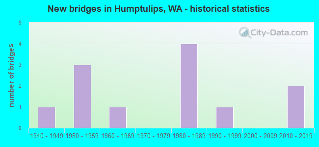
- New bridges - historical statistics
- 11940-1949
- 31950-1959
- 11960-1969
- 41980-1989
- 11990-1999
- 22010-2019


- Bridge Condition - Deck
- 9.1%Excellent
- 45.5%Good
- 36.4%Satisfactory
- 9.1%Fair

- Bridge Condition - Superstructure
- 81.8%Good
- 9.1%Satisfactory
- 9.1%Fair

- Bridge Condition - Substructure
- 9.1%Excellent
- 63.6%Good
- 18.2%Satisfactory
- 9.1%Fair

- Bridge Condition - Channel
- 8.3%Excellent
- 41.7%Very good
- 25.0%Good
- 25.0%Satisfactory
Find on map >> Show street view
Structure Number: 3765A, Location: 21.3 N JCT SR 109 (Lat: 47.227319, Lng: -123.964750), Route carried "on" structure: US 101, Year Built: 1950, Status: Open, Structure Length: 4.75m (15.58ft), Average Daily Traffic: 2,217 (year 2019), Truck Traffic: 14%, Average Future Daily Traffic: 2,536 (year 2039), Design Load: HS 20, Features Intersected: HUMPTULIPS OVERFLOW
Minimum Vertical Clearance: 30+ m (98+ ft), Kilometerpoint: 175.161, Lanes on structure: 2, Base Highway Network: Yes, Owner: State Highway Agency, Approaching Roadway Width: 10.4m (34.1ft), Material/Design: Concrete continuous, Design/Construction: Tee Beam, Number Of Spans In Main Unit: 3, Length of Maximum Span: 19.8m (65.0ft), Curb or Sidewalk Widths: Left: 0.8m (2.6ft), Right: 0.8m (2.6ft), Curb-To-Curb Width: 7.9m (25.9ft), Out-to-Out Width: 10.4m (34.1ft)
Condition: Deck: Satisfactory, Superstructure: Good, Substructure: Good, Channel: Good, Operating Rating: 78.0 metric tons, Method Used To Determine Operating Rating: Load Factor (LF), Inventory Rating: 46.3 metric tons, Method Used To Determine Inventory Rating: Load Factor (LF), Structural Evaluation: Better than present minimum criteria, Deck Geometry: High priority of corrective action, Waterway Adequacy: Equal to present desirable criteria, Approach Roadway Alignment: Equal to present desirable criteria, Length Of Structure Improvement: 4.75m (15.58ft), Designated Inspection Frequency: Every 24 months, Inspection Date: June 2021, Bridge Improvement Cost: $1,123,000, Roadway Improvement Cost: $225,000, Total Project Cost: $2,246,000 ( Estimate for 2014), Deck Structure Type: Concrete Cast-file-Place, Wearing Surface/Protective System: Wearing Surface: Bituminous, Membrane: Preformed Fabric
Find on map >> Show street view
Structure Number: 3765B, Location: 21.5 N JCT SR 109 (Lat: 47.229475, Lng: -123.962250), Route carried "on" structure: US 101, Year Built: 1950, Status: Open, Structure Length: 13.72m (45.01ft), Average Daily Traffic: 2,217 (year 2019), Truck Traffic: 14%, Average Future Daily Traffic: 2,536 (year 2039), Design Load: HS 20, Features Intersected: HUMPTULIPS RIVER
Minimum Vertical Clearance: 4.52m (14.83ft), Kilometerpoint: 175.418, Lanes on structure: 2, Base Highway Network: Yes, Owner: State Highway Agency, Approaching Roadway Width: 11.6m (38.1ft), Navigation Control: Yes ( Vertical Clearance: 4.9m (16.1ft), Horizontal Clearance: 71.6m (234.9ft)), Material/Design: Steel, Design/Construction: Truss - Thru, Number Of Spans In Main Unit: 1, Number Of Approach Spans: 3, Length of Maximum Span: 79.2m (259.8ft), Curb or Sidewalk Widths: Left: 0.8m (2.6ft), Right: 0.8m (2.6ft), Curb-To-Curb Width: 7.9m (25.9ft), Out-to-Out Width: 9.9m (32.5ft)
Condition: Deck: Satisfactory, Superstructure: Fair, Substructure: Good, Channel: Very good, Operating Rating: 59.0 metric tons, Method Used To Determine Operating Rating: Load Factor (LF), Inventory Rating: 35.4 metric tons, Method Used To Determine Inventory Rating: Load Factor (LF), Structural Evaluation: Somewhat better than minimum adequacy, Deck Geometry: High priority of corrective action, Waterway Adequacy: Equal to present desirable criteria, Approach Roadway Alignment: Equal to present desirable criteria, Length Of Structure Improvement: 13.72m (45.01ft), Designated Inspection Frequency: Every 24 months, Critical Feature Inspection Frequency: Every 24 months, Inspection Date: June 2020, Critical Feature Inspection Date: June 2020, Bridge Improvement Cost: $3,600,000, Roadway Improvement Cost: $720,000, Total Project Cost: $7,200,000 ( Estimate for 2014), Deck Structure Type: Concrete Cast-file-Place, Wearing Surface/Protective System: Wearing Surface: Bituminous, Membrane: Preformed Fabric
Find on map >> Show street view
Structure Number: 12926A, Location: 24.7 N JCT SR 109 (Lat: 47.262833, Lng: -123.920611), Route carried "on" structure: US 101, Year Built: 1986, Status: Open, Structure Length: 4.27m (14.01ft), Average Daily Traffic: 1,886 (year 2019), Truck Traffic: 25%, Average Future Daily Traffic: 2,157 (year 2039), Design Load: HS 20+Mod, Features Intersected: STEVENS CREEK
Minimum Vertical Clearance: 30+ m (98+ ft), Kilometerpoint: 180.649, Lanes on structure: 2, Base Highway Network: Yes, Owner: State Highway Agency, Approaching Roadway Width: 11.3m (37.1ft), Skew: 2 degrees, Material/Design: Prestressed concrete continuous, Design/Construction: Slab, Number Of Spans In Main Unit: 2, Length of Maximum Span: 20.7m (67.9ft), Curb-To-Curb Width: 11.3m (37.1ft), Out-to-Out Width: 12.2m (40.0ft)
Condition: Deck: Good, Superstructure: Good, Substructure: Good, Channel: Very good, Operating Rating: 14.9 metric tons, Method Used To Determine Operating Rating: Load and Resistance Factor Rating (LRFR) rating reported by rating factor(RF) method using HL-93 loadings, Inventory Rating: 11.3 metric tons, Method Used To Determine Inventory Rating: Load and Resistance Factor Rating (LRFR) rating reported by rating factor(RF) method using HL-93 loadings, Structural Evaluation: High priority of corrective action, Deck Geometry: Equal to present minimum criteria, Waterway Adequacy: Equal to present desirable criteria, Approach Roadway Alignment: Equal to present desirable criteria, Length Of Structure Improvement: 4.27m (14.01ft), Designated Inspection Frequency: Every 24 months, Inspection Date: July 2021, Bridge Improvement Cost: $1,092,000, Roadway Improvement Cost: $218,000, Total Project Cost: $2,184,000 ( Estimate for 2014), Deck Structure Type: Concrete Precast Panels, Wearing Surface/Protective System: Wearing Surface: Bituminous, Membrane: Preformed Fabric, Deck Protection: Epoxy Coated Reinforcing
Find on map >> Show street view
Structure Number: 60903000001074, Location: NO DATA ENTERED (Lat: 47.272503, Lng: -123.910017), Route carried "on" structure: Federal lands road 22000, Year Built: 1954, Status: Open, Structure Length: 2.44m (8.01ft), Average Daily Traffic: 150 (year 2006), Truck Traffic: 20%, Average Future Daily Traffic: 225 (year 2042), Design Load: HS 20, Features Intersected: STEVENS CREEK
Minimum Vertical Clearance: 30+ m (98+ ft), Kilometerpoint: 0.640, Lanes on structure: 2, Owner: U.S. Forest Service, Approaching Roadway Width: 7.9m (25.9ft), Skew: 2 degrees, Material/Design: Concrete continuous, Design/Construction: Frame, Number Of Spans In Main Unit: 3, Length of Maximum Span: 15.2m (49.9ft), Curb-To-Curb Width: 7.9m (25.9ft), Out-to-Out Width: 8.8m (28.9ft)
Condition: Deck: Satisfactory, Superstructure: Good, Substructure: Good, Channel: Good, Operating Rating: 36.3 metric tons, Method Used To Determine Operating Rating: Load Factor (LF), Inventory Rating: 25.4 metric tons, Method Used To Determine Inventory Rating: Load Factor (LF), Structural Evaluation: Equal to present minimum criteria, Deck Geometry: Somewhat better than minimum adequacy, Waterway Adequacy: Equal to present desirable criteria, Approach Roadway Alignment: Equal to present desirable criteria, Designated Inspection Frequency: Every 48 months, Inspection Date: August 2021, Deck Structure Type: Concrete Cast-file-Place, Wearing Surface/Protective System: Wearing Surface: Other
Find on map >> Show street view
Structure Number: 60903000001075, Location: NO DATA ENTERED (Lat: 47.296967, Lng: -123.836397), Route carried "on" structure: Federal lands road 22000, Year Built: 1948, Status: Open, Structure Length: 6.84m (22.44ft), Average Daily Traffic: 150 (year 2006), Truck Traffic: 20%, Average Future Daily Traffic: 225 (year 2042), Design Load: HS 20, Features Intersected: W FK HUMPTULIPS RIVER
Minimum Vertical Clearance: 30+ m (98+ ft), Kilometerpoint: 7.680, Lanes on structure: 2, Owner: U.S. Forest Service, Approaching Roadway Width: 7.9m (25.9ft), Material/Design: Steel, Design/Construction: Stringer/Multi-beam, Number Of Spans In Main Unit: 1, Number Of Approach Spans: 2, Length of Maximum Span: 39.6m (129.9ft), Curb-To-Curb Width: 7.9m (25.9ft), Out-to-Out Width: 8.8m (28.9ft)
Condition: Deck: Satisfactory, Superstructure: Satisfactory, Substructure: Satisfactory, Channel: Satisfactory, Operating Rating: 44.5 metric tons, Method Used To Determine Operating Rating: Load Factor (LF), Inventory Rating: 30.9 metric tons, Method Used To Determine Inventory Rating: Load Factor (LF), Structural Evaluation: Equal to present minimum criteria, Deck Geometry: Somewhat better than minimum adequacy, Waterway Adequacy: Superior to present desirable criteria, Approach Roadway Alignment: Equal to present desirable criteria, Designated Inspection Frequency: Every 24 months, Other Special Inspection Frequency: Every 72 months, Inspection Date: August 2021, Other Special Inspection Date: July 2019, Deck Structure Type: Concrete Cast-file-Place, Wearing Surface/Protective System: Wearing Surface: Other
Find on map >> Show street view
Structure Number: 60903000013131, Location: OFF HWY 101,3.7 MI FSR 22 (Lat: 47.290858, Lng: -123.855303), Route carried "on" structure: Federal lands road 22000, Year Built: 2010, Status: Open, Structure Length: 5.57m (18.27ft), Average Daily Traffic: 150 (year 2006), Truck Traffic: 20%, Average Future Daily Traffic: 225 (year 2042), Design Load: HL 93, Features Intersected: O'BRIEN CREEK, Facility Carried by Structure: DONKEY CR ROAD
Minimum Vertical Clearance: 30+ m (98+ ft), Kilometerpoint: 5.920, Lanes on structure: 2, Owner: U.S. Forest Service, Approaching Roadway Width: 8.5m (27.9ft), Material/Design: Prestressed concrete, Design/Construction: Stringer/Multi-beam, Number Of Spans In Main Unit: 1, Length of Maximum Span: 54.2m (177.8ft), Curb or Sidewalk Widths: Left: 0.5m (1.6ft), Right: 0.5m (1.6ft), Curb-To-Curb Width: 8.5m (27.9ft), Out-to-Out Width: 9.5m (31.2ft)
Condition: Deck: Excellent, Superstructure: Good, Substructure: Excellent, Channel: Excellent, Operating Rating: 80.8 metric tons, Method Used To Determine Operating Rating: Load Factor (LF), Inventory Rating: 47.2 metric tons, Method Used To Determine Inventory Rating: Load Factor (LF), Structural Evaluation: Better than present minimum criteria, Deck Geometry: Equal to present minimum criteria, Waterway Adequacy: Superior to present desirable criteria, Approach Roadway Alignment: Equal to present desirable criteria, Designated Inspection Frequency: Every 24 months, Inspection Date: August 2020, Deck Structure Type: Concrete Cast-file-Place
Find on map >> Show street view
Structure Number: 81135, Location: 03.3 E JCT SR101 (Lat: 47.237056, Lng: -123.915764), Route carried "on" structure: County highway 49680, Year Built: 1983, Status: Open, Structure Length: 3.60m (11.81ft), Average Daily Traffic: 41 (year 2021), Truck Traffic: 20%, Average Future Daily Traffic: 50 (year 2041), Design Load: HS 20, Features Intersected: ELWOOD CREEK, Facility Carried by Structure: EAST HUMPTULIPS RD
Minimum Vertical Clearance: 30+ m (98+ ft), Kilometerpoint: 0.001, Lanes on structure: 2, Owner: County Highway Agency, Approaching Roadway Width: 6.1m (20.0ft), Material/Design: Prestressed concrete, Design/Construction: Slab, Number Of Spans In Main Unit: 4, Length of Maximum Span: 9.8m (32.2ft), Curb-To-Curb Width: 6.9m (22.6ft), Out-to-Out Width: 7.3m (24.0ft)
Condition: Deck: Good, Superstructure: Good, Substructure: Good, Channel: Satisfactory, Operating Rating: 55.3 metric tons, Method Used To Determine Operating Rating: Load Factor (LF), Inventory Rating: 32.7 metric tons, Method Used To Determine Inventory Rating: Load Factor (LF), Structural Evaluation: Better than present minimum criteria, Deck Geometry: Somewhat better than minimum adequacy, Waterway Adequacy: Equal to present desirable criteria, Approach Roadway Alignment: Equal to present desirable criteria, Designated Inspection Frequency: Every 24 months, Inspection Date: December 2021, Deck Structure Type: Concrete Precast Panels, Wearing Surface/Protective System: Wearing Surface: Bituminous
Find on map >> Show street view
Structure Number: 81485, Location: 01.4 W JCT SR 101 (Lat: 47.234167, Lng: -123.986111), Route carried "on" structure: County highway 93310, Year Built: 1961, Status: Open, Structure Length: 6.71m (22.01ft), Average Daily Traffic: 439 (year 2021), Truck Traffic: 16%, Average Future Daily Traffic: 536 (year 2041), Design Load: HS 15, Features Intersected: STEVENS CREEK, Facility Carried by Structure: KIRKPATRICK RD.
Minimum Vertical Clearance: 30+ m (98+ ft), Kilometerpoint: 0.001, Lanes on structure: 2, Owner: County Highway Agency, Approaching Roadway Width: 7.9m (25.9ft), Material/Design: Prestressed concrete, Design/Construction: Stringer/Multi-beam, Number Of Spans In Main Unit: 5, Length of Maximum Span: 13.4m (44.0ft), Curb or Sidewalk Widths: Left: 0.2m (0.7ft), Right: 0.2m (0.7ft), Curb-To-Curb Width: 7.3m (24.0ft), Out-to-Out Width: 7.9m (25.9ft)
Condition: Deck: Fair, Superstructure: Good, Substructure: Fair, Channel: Good, Operating Rating: 45.4 metric tons, Method Used To Determine Operating Rating: Load Factor (LF), Inventory Rating: 27.2 metric tons, Method Used To Determine Inventory Rating: Load Factor (LF), Structural Evaluation: Somewhat better than minimum adequacy, Deck Geometry: Meets minimum limits, Waterway Adequacy: Equal to present desirable criteria, Approach Roadway Alignment: Equal to present desirable criteria, Designated Inspection Frequency: Every 24 months, Inspection Date: December 2021, Deck Structure Type: Concrete Cast-file-Place, Wearing Surface/Protective System: Wearing Surface: Monolithic Concrete
Find on map >> Show street view
Structure Number: 83618, Location: 00.8 N JCT 9423 (Lat: 47.101353, Lng: -124.044708), Route carried "on" structure: County highway 43310, Year Built: 1985, Status: Open, Structure Length: 2.10m (6.89ft), Average Daily Traffic: 52 (year 2020), Truck Traffic: 25%, Average Future Daily Traffic: 63 (year 2040), Design Load: HS 20, Features Intersected: LITTLE CREEK, Facility Carried by Structure: HUMPTULIPS VALLEY
Minimum Vertical Clearance: 30+ m (98+ ft), Kilometerpoint: 0.001, Lanes on structure: 2, Owner: County Highway Agency, Approaching Roadway Width: 7.9m (25.9ft), Material/Design: Prestressed concrete, Design/Construction: Slab, Number Of Spans In Main Unit: 3, Length of Maximum Span: 9.4m (30.8ft), Curb-To-Curb Width: 8.1m (26.6ft), Out-to-Out Width: 8.5m (27.9ft)
Condition: Deck: Good, Superstructure: Good, Substructure: Satisfactory, Channel: Satisfactory, Operating Rating: 52.6 metric tons, Method Used To Determine Operating Rating: Load Factor (LF), Inventory Rating: 30.8 metric tons, Method Used To Determine Inventory Rating: Load Factor (LF), Structural Evaluation: Equal to present minimum criteria, Deck Geometry: Equal to present minimum criteria, Waterway Adequacy: Better than present minimum criteria, Approach Roadway Alignment: Equal to present desirable criteria, Designated Inspection Frequency: Every 24 months, Inspection Date: December 2021, Deck Structure Type: Concrete Precast Panels, Wearing Surface/Protective System: Wearing Surface: Bituminous, Membrane: Preformed Fabric, Deck Protection: Epoxy Coated Reinforcing
Find on map >> Show street view
Structure Number: 85636, Location: 0.8 S JCT SR 101 (Lat: 47.185625, Lng: -123.952639), Route carried "on" structure: County highway 48650, Year Built: 1989, Status: Open, Structure Length: 1.77m (5.81ft), Average Daily Traffic: 193 (year 2018), Truck Traffic: 10%, Average Future Daily Traffic: 235 (year 2038), Design Load: HS 20, Features Intersected: HANSEN CREEK, Facility Carried by Structure: WALKER ROAD
Minimum Vertical Clearance: 30+ m (98+ ft), Kilometerpoint: 0.001, Lanes on structure: 2, Owner: County Highway Agency, Approaching Roadway Width: 8.5m (27.9ft), Material/Design: Wood or Timber, Design/Construction: Stringer/Multi-beam, Number Of Spans In Main Unit: 1, Length of Maximum Span: 17.7m (58.1ft), Curb-To-Curb Width: 8.5m (27.9ft), Out-to-Out Width: 8.8m (28.9ft)
Condition: Deck: Good, Superstructure: Good, Substructure: Good, Channel: Very good, Operating Rating: 59.0 metric tons, Method Used To Determine Operating Rating: Allowable Stress (AS), Inventory Rating: 40.8 metric tons, Method Used To Determine Inventory Rating: Allowable Stress (AS), Structural Evaluation: Better than present minimum criteria, Deck Geometry: Equal to present minimum criteria, Waterway Adequacy: Equal to present desirable criteria, Approach Roadway Alignment: Equal to present desirable criteria, Designated Inspection Frequency: Every 24 months, Inspection Date: November 2020, Deck Structure Type: Wood or Timber, Wearing Surface/Protective System: Wearing Surface: Bituminous, Membrane: Other
Find on map >> Show street view
Structure Number: 85815, Location: 02.8 E JCT SR101 (Lat: 47.231583, Lng: -123.922917), Route carried "on" structure: County highway 49680, Year Built: 1990, Status: Open, Structure Length: 5.30m (17.39ft), Average Daily Traffic: 41 (year 2021), Truck Traffic: 20%, Average Future Daily Traffic: 50 (year 2041), Design Load: HS 20, Features Intersected: BRITTAIN CREEK, Facility Carried by Structure: EAST HUMPTULIPS RD
Minimum Vertical Clearance: 30+ m (98+ ft), Kilometerpoint: 0.001, Lanes on structure: 2, Owner: County Highway Agency, Approaching Roadway Width: 8.5m (27.9ft), Skew: 1 degrees, Material/Design: Prestressed concrete, Design/Construction: Stringer/Multi-beam, Number Of Spans In Main Unit: 2, Length of Maximum Span: 25.6m (84.0ft), Curb-To-Curb Width: 8.5m (27.9ft), Out-to-Out Width: 9.4m (30.8ft)
Condition: Deck: Good, Superstructure: Good, Substructure: Good, Channel: Very good, Operating Rating: 71.7 metric tons, Method Used To Determine Operating Rating: Load Factor (LF), Inventory Rating: 42.6 metric tons, Method Used To Determine Inventory Rating: Load Factor (LF), Structural Evaluation: Better than present minimum criteria, Deck Geometry: Better than present minimum criteria, Waterway Adequacy: Equal to present desirable criteria, Approach Roadway Alignment: Equal to present desirable criteria, Designated Inspection Frequency: Every 24 months, Inspection Date: December 2021, Deck Structure Type: Concrete Cast-file-Place, Wearing Surface/Protective System: Wearing Surface: Monolithic Concrete, Deck Protection: Epoxy Coated Reinforcing
Find on map >> Show street view
Structure Number: 8887, Location: 0.7 MI NE JCT US101 (Lat: 47.170833, Lng: -123.875000), Route carried "on" structure: County highway 47830, Year Built: 2016, Status: Open, Structure Length: 0.79m (2.59ft), Average Daily Traffic: 40 (year 2017), Truck Traffic: 5%, Average Future Daily Traffic: 50 (year 2037), Design Load: HL 93, Features Intersected: BIG CREEK, Facility Carried by Structure: POLSON CAMP ROAD
Minimum Vertical Clearance: 30+ m (98+ ft), Kilometerpoint: 0.001, Lanes on structure: 2, Owner: County Highway Agency, Approaching Roadway Width: 6.7m (22.0ft), Skew: 2 degrees, Material/Design: Steel, Design/Construction: Culvert, Number Of Spans In Main Unit: 1, Length of Maximum Span: 7.9m (25.9ft)
Condition: Channel: Very good, Culverts: Very good, Operating Rating: 96.9 metric tons, Method Used To Determine Operating Rating: Load and Resistance Factor Rating (LRFR) rating reported by rating factor(RF) method using HL-93 loadings, Inventory Rating: 96.9 metric tons, Method Used To Determine Inventory Rating: Load and Resistance Factor Rating (LRFR) rating reported by rating factor(RF) method using HL-93 loadings, Structural Evaluation: Equal to present desirable criteria, Waterway Adequacy: Equal to present desirable criteria, Approach Roadway Alignment: Equal to present desirable criteria, Designated Inspection Frequency: Every 24 months, Inspection Date: December 2020