Bridge Statistics for Hunters Creek, Florida (FL)
Condition, Traffic, Stress, Structural Evaluation, Project Costs
- National Bridge Inventory (NBI) Statistics
- 42Number of bridges
- 771ft / 235mTotal length
- 1,238,886Total average daily traffic
- 77,026Total average daily truck traffic
- National Bridge Inventory (NBI) Registered Bridges for Hunters Creek
- No street view available for this location
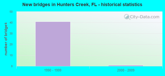
- New bridges - historical statistics
- 411990-1999
- 12000-2009
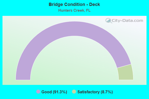
- Bridge Condition - Deck
- 91.3%Good
- 8.7%Satisfactory
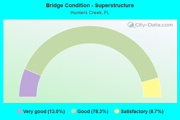
- Bridge Condition - Superstructure
- 13.0%Very good
- 78.3%Good
- 8.7%Satisfactory
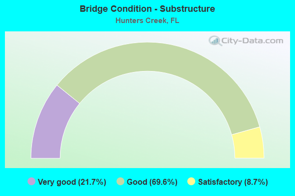
- Bridge Condition - Substructure
- 21.7%Very good
- 69.6%Good
- 8.7%Satisfactory
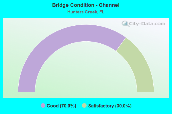
- Bridge Condition - Channel
- 70.0%Good
- 30.0%Satisfactory
Find on map >> Show street view
Structure Number: 750424, Location: SR-417 Hunters Vista Blvd (Lat: 28.356950, Lng: -81.452317), Route carried "on" structure: State highway 417, Year Built: 1993, Status: Open, Structure Length: 4.43m (14.53ft), Average Daily Traffic: 35,000 (year 2020), Truck Traffic: 7%, Average Future Daily Traffic: 60,725 (year 2042), Design Load: HS 20+Mod, Features Intersected: Hunters Vista Blvd.
Minimum Vertical Clearance: 30+ m (98+ ft), Kilometerpoint: 2.519, Lanes on structure: 2, Lanes under structure: 2, Base Highway Network: Yes, Toll: On toll road, Owner: State Toll Authority, Approaching Roadway Width: 13.3m (43.6ft), Skew: 3 degrees, Material/Design: Prestressed concrete, Design/Construction: Stringer/Multi-beam, Number Of Spans In Main Unit: 1, Length of Maximum Span: 43.7m (143.4ft), Curb-To-Curb Width: 13.7m (44.9ft), Out-to-Out Width: 14.6m (47.9ft)
Condition: Deck: Good, Superstructure: Good, Substructure: Very good, Inventory Rating: 62.5 metric tons, Method Used To Determine Inventory Rating: Load Factor (LF), Structural Evaluation: Better than present minimum criteria, Deck Geometry: Superior to present desirable criteria, Underclear: Equal to present minimum criteria, Approach Roadway Alignment: Equal to present desirable criteria, Designated Inspection Frequency: Every 24 months, Inspection Date: September 2021, Deck Structure Type: Concrete Cast-file-Place
Find on map >> Show street view
Structure Number: 750425, Location: SR-417 Hunters Vista Blvd (Lat: 28.357278, Lng: -81.452250), Route carried "on" structure: State highway 417, Year Built: 1993, Status: Open, Structure Length: 4.44m (14.57ft), Average Daily Traffic: 35,000 (year 2020), Truck Traffic: 7%, Average Future Daily Traffic: 60,725 (year 2042), Design Load: HS 20+Mod, Features Intersected: Hunters Vista Blvd.
Minimum Vertical Clearance: 30+ m (98+ ft), Kilometerpoint: 2.535, Lanes on structure: 2, Lanes under structure: 3, Base Highway Network: Yes, Toll: On toll road, Owner: State Toll Authority, Approaching Roadway Width: 10.7m (35.1ft), Skew: 3 degrees, Material/Design: Prestressed concrete, Design/Construction: Stringer/Multi-beam, Number Of Spans In Main Unit: 1, Length of Maximum Span: 43.8m (143.7ft), Curb-To-Curb Width: 12.2m (40.0ft), Out-to-Out Width: 13.1m (43.0ft)
Condition: Deck: Good, Superstructure: Good, Substructure: Very good, Inventory Rating: 61.7 metric tons, Method Used To Determine Inventory Rating: Load Factor (LF), Structural Evaluation: Better than present minimum criteria, Deck Geometry: Better than present minimum criteria, Underclear: Equal to present minimum criteria, Approach Roadway Alignment: Equal to present desirable criteria, Designated Inspection Frequency: Every 24 months, Inspection Date: September 2021, Deck Structure Type: Concrete Cast-file-Place
Find on map >> Show street view
Structure Number: 750426, Location: 1.3 Mi South of Jn Yng Pk (Lat: 28.359403, Lng: -81.443139), Route carried "on" structure: State highway 417, Year Built: 1993, Status: Open, Structure Length: 25.85m (84.81ft), Average Daily Traffic: 35,000 (year 2020), Truck Traffic: 7%, Average Future Daily Traffic: 60,725 (year 2042), Design Load: HS 20+Mod, Features Intersected: Shingle Creek
Minimum Vertical Clearance: 30+ m (98+ ft), Kilometerpoint: 3.354, Lanes on structure: 2, Base Highway Network: Yes, Toll: On toll road, Owner: State Toll Authority, Approaching Roadway Width: 11.3m (37.1ft), Skew: 3 degrees, Material/Design: Prestressed concrete, Design/Construction: Stringer/Multi-beam, Number Of Spans In Main Unit: 10, Length of Maximum Span: 26.4m (86.6ft), Curb-To-Curb Width: 12.2m (40.0ft), Out-to-Out Width: 13.1m (43.0ft)
Condition: Deck: Good, Superstructure: Good, Substructure: Good, Channel: Good, Operating Rating: 89.2 metric tons, Method Used To Determine Operating Rating: Load Factor (LF), Inventory Rating: 53.5 metric tons, Method Used To Determine Inventory Rating: Load Factor (LF), Structural Evaluation: Better than present minimum criteria, Deck Geometry: Better than present minimum criteria, Waterway Adequacy: Superior to present desirable criteria, Approach Roadway Alignment: Better than present minimum criteria, Designated Inspection Frequency: Every 24 months, Underwater Inspection Frequency: Every 24 months, Inspection Date: September 2021, Underwater Inspection Date: September 2021, Deck Structure Type: Concrete Cast-file-Place
Find on map >> Show street view
Structure Number: 750427, Location: 1.3 Mi South of Jn Yng Pk (Lat: 28.359094, Lng: -81.443222), Route carried "on" structure: State highway 417, Year Built: 1993, Status: Open, Structure Length: 24.90m (81.69ft), Average Daily Traffic: 35,000 (year 2020), Truck Traffic: 7%, Average Future Daily Traffic: 60,725 (year 2042), Design Load: HS 20, Features Intersected: Shingle Creek
Minimum Vertical Clearance: 30+ m (98+ ft), Kilometerpoint: 3.318, Lanes on structure: 2, Base Highway Network: Yes, Toll: On toll road, Owner: State Toll Authority, Approaching Roadway Width: 11.3m (37.1ft), Skew: 3 degrees, Material/Design: Prestressed concrete, Design/Construction: Stringer/Multi-beam, Number Of Spans In Main Unit: 10, Length of Maximum Span: 24.7m (81.0ft), Curb-To-Curb Width: 12.2m (40.0ft), Out-to-Out Width: 13.1m (43.0ft)
Condition: Deck: Good, Superstructure: Good, Substructure: Good, Channel: Good, Operating Rating: 85.4 metric tons, Method Used To Determine Operating Rating: Load Factor (LF), Inventory Rating: 51.3 metric tons, Method Used To Determine Inventory Rating: Load Factor (LF), Structural Evaluation: Better than present minimum criteria, Deck Geometry: Better than present minimum criteria, Waterway Adequacy: Superior to present desirable criteria, Approach Roadway Alignment: Equal to present desirable criteria, Designated Inspection Frequency: Every 24 months, Underwater Inspection Frequency: Every 24 months, Inspection Date: September 2021, Underwater Inspection Date: September 2021, Deck Structure Type: Concrete Cast-file-Place
Find on map >> Show street view
Structure Number: 750428, Location: SR-417 Town Loop Blvd. (Lat: 28.366767, Lng: -81.432983), Route carried "on" structure: State highway 417, Year Built: 1993, Status: Open, Structure Length: 3.90m (12.80ft), Average Daily Traffic: 35,000 (year 2020), Truck Traffic: 7%, Average Future Daily Traffic: 60,725 (year 2042), Design Load: HS 20, Features Intersected: Town Loop Blvd.
Minimum Vertical Clearance: 30+ m (98+ ft), Kilometerpoint: 4.775, Lanes on structure: 2, Lanes under structure: 3, Base Highway Network: Yes, Toll: On toll road, Owner: State Toll Authority, Approaching Roadway Width: 11.6m (38.1ft), Skew: 1 degrees, Material/Design: Prestressed concrete, Design/Construction: Stringer/Multi-beam, Number Of Spans In Main Unit: 1, Length of Maximum Span: 38.3m (125.7ft), Curb-To-Curb Width: 12.2m (40.0ft), Out-to-Out Width: 13.1m (43.0ft)
Condition: Deck: Good, Superstructure: Good, Substructure: Very good, Inventory Rating: 58.0 metric tons, Method Used To Determine Inventory Rating: Load Factor (LF), Structural Evaluation: Better than present minimum criteria, Deck Geometry: Better than present minimum criteria, Underclear: Superior to present desirable criteria, Approach Roadway Alignment: Equal to present desirable criteria, Designated Inspection Frequency: Every 24 months, Inspection Date: September 2021, Deck Structure Type: Concrete Cast-file-Place
Find on map >> Show street view
Structure Number: 750429, Location: SR-417 Town Loop Blvd. (Lat: 28.366553, Lng: -81.432808), Route carried "on" structure: State highway 417, Year Built: 1993, Status: Open, Structure Length: 3.94m (12.93ft), Average Daily Traffic: 35,000 (year 2020), Truck Traffic: 7%, Average Future Daily Traffic: 60,725 (year 2042), Design Load: HS 20, Features Intersected: Town Loop Blvd.
Minimum Vertical Clearance: 30+ m (98+ ft), Kilometerpoint: 4.772, Lanes on structure: 2, Lanes under structure: 2, Base Highway Network: Yes, Toll: On toll road, Owner: State Toll Authority, Approaching Roadway Width: 11.8m (38.7ft), Skew: 1 degrees, Material/Design: Prestressed concrete, Design/Construction: Stringer/Multi-beam, Number Of Spans In Main Unit: 1, Length of Maximum Span: 38.8m (127.3ft), Curb-To-Curb Width: 12.2m (40.0ft), Out-to-Out Width: 13.1m (43.0ft)
Condition: Deck: Good, Superstructure: Good, Substructure: Very good, Inventory Rating: 58.0 metric tons, Method Used To Determine Inventory Rating: Load Factor (LF), Structural Evaluation: Better than present minimum criteria, Deck Geometry: Better than present minimum criteria, Underclear: Superior to present desirable criteria, Approach Roadway Alignment: Equal to present desirable criteria, Designated Inspection Frequency: Every 24 months, Inspection Date: September 2021, Deck Structure Type: Concrete Cast-file-Place
Find on map >> Show street view
Structure Number: 75043, Location: SR-417 John Young Pkwy (Lat: 28.372831, Lng: -81.425831), Route carried "on" structure: State highway 417, Year Built: 1993, Status: Open, Structure Length: 6.25m (20.51ft), Average Daily Traffic: 35,000 (year 2020), Truck Traffic: 7%, Average Future Daily Traffic: 60,725 (year 2042), Design Load: HS 20+Mod, Features Intersected: CR-423 John Yng Pkwy
Minimum Vertical Clearance: 30+ m (98+ ft), Kilometerpoint: 5.731, Lanes on structure: 2, Lanes under structure: 8, Base Highway Network: Yes, Toll: On toll road, Owner: State Toll Authority, Approaching Roadway Width: 11.5m (37.7ft), Skew: 3 degrees, Material/Design: Steel, Design/Construction: Stringer/Multi-beam, Number Of Spans In Main Unit: 1, Length of Maximum Span: 61.9m (203.1ft), Curb-To-Curb Width: 12.2m (40.0ft), Out-to-Out Width: 13.1m (43.0ft)
Condition: Deck: Good, Superstructure: Very good, Substructure: Good, Operating Rating: 65.3 metric tons, Method Used To Determine Operating Rating: Load Factor (LF), Inventory Rating: 39.2 metric tons, Method Used To Determine Inventory Rating: Load Factor (LF), Structural Evaluation: Better than present minimum criteria, Deck Geometry: Better than present minimum criteria, Underclear: Equal to present minimum criteria, Approach Roadway Alignment: Equal to present desirable criteria, Designated Inspection Frequency: Every 24 months, Inspection Date: September 2021, Deck Structure Type: Concrete Cast-file-Place
Find on map >> Show street view
Structure Number: 750431, Location: SR-417 John Young Pkwy (Lat: 28.372514, Lng: -81.425817), Route carried "on" structure: State highway 417, Year Built: 1993, Status: Open, Structure Length: 6.34m (20.80ft), Average Daily Traffic: 35,000 (year 2020), Truck Traffic: 7%, Average Future Daily Traffic: 60,725 (year 2042), Design Load: HS 20+Mod, Features Intersected: CR-423 John Yng Pkwy
Minimum Vertical Clearance: 30+ m (98+ ft), Kilometerpoint: 5.713, Lanes on structure: 2, Lanes under structure: 8, Base Highway Network: Yes, Toll: On toll road, Owner: State Toll Authority, Approaching Roadway Width: 10.9m (35.8ft), Skew: 3 degrees, Material/Design: Steel, Design/Construction: Stringer/Multi-beam, Number Of Spans In Main Unit: 1, Length of Maximum Span: 62.8m (206.0ft), Curb-To-Curb Width: 12.2m (40.0ft), Out-to-Out Width: 13.1m (43.0ft)
Condition: Deck: Good, Superstructure: Good, Substructure: Good, Operating Rating: 65.3 metric tons, Method Used To Determine Operating Rating: Load Factor (LF), Inventory Rating: 39.2 metric tons, Method Used To Determine Inventory Rating: Load Factor (LF), Structural Evaluation: Better than present minimum criteria, Deck Geometry: Better than present minimum criteria, Underclear: Equal to present minimum criteria, Approach Roadway Alignment: Equal to present desirable criteria, Designated Inspection Frequency: Every 24 months, Inspection Date: September 2021, Deck Structure Type: Concrete Cast-file-Place
Find on map >> Show street view
Structure Number: 750432, Location: SR-417 SB Off Ramp-SR-423 (Lat: 28.373022, Lng: -81.425836), Route carried "on" structure: Ramp State highway 417, Year Built: 1993, Status: Open, Structure Length: 6.24m (20.47ft), Average Daily Traffic: 3,700 (year 2020), Truck Traffic: 6%, Average Future Daily Traffic: 6,420 (year 2042), Design Load: HS 20+Mod, Features Intersected: CR-423 John Young Pkwy
Minimum Vertical Clearance: 30+ m (98+ ft), Kilometerpoint: 0.298, Lanes on structure: 1, Lanes under structure: 8, Toll: On toll road, Owner: State Toll Authority, Approaching Roadway Width: 8.2m (26.9ft), Skew: 3 degrees, Material/Design: Steel, Design/Construction: Stringer/Multi-beam, Number Of Spans In Main Unit: 1, Length of Maximum Span: 61.8m (202.8ft), Curb-To-Curb Width: 8.5m (27.9ft), Out-to-Out Width: 9.1m (29.9ft)
Condition: Deck: Good, Superstructure: Good, Substructure: Good, Operating Rating: 65.3 metric tons, Method Used To Determine Operating Rating: Load Factor (LF), Inventory Rating: 39.2 metric tons, Method Used To Determine Inventory Rating: Load Factor (LF), Structural Evaluation: Better than present minimum criteria, Deck Geometry: Superior to present desirable criteria, Underclear: Equal to present minimum criteria, Approach Roadway Alignment: Better than present minimum criteria, Designated Inspection Frequency: Every 24 months, Inspection Date: September 2021, Deck Structure Type: Concrete Cast-file-Place
Find on map >> Show street view
Structure Number: 750433, Location: SR-417 US-17/SR-500 (Lat: 28.372397, Lng: -81.404525), Route carried "on" structure: State highway 417, Year Built: 1993, Status: Open, Structure Length: 5.42m (17.78ft), Average Daily Traffic: 41,500 (year 2020), Truck Traffic: 7%, Average Future Daily Traffic: 72,002 (year 2042), Design Load: HS 20+Mod, Features Intersected: US-17/SR-500
Minimum Vertical Clearance: 30+ m (98+ ft), Kilometerpoint: 7.910, Lanes on structure: 3, Lanes under structure: 7, Base Highway Network: Yes, Toll: On toll road, Owner: State Toll Authority, Approaching Roadway Width: 14.5m (47.6ft), Skew: 2 degrees, Material/Design: Steel, Design/Construction: Stringer/Multi-beam, Number Of Spans In Main Unit: 1, Length of Maximum Span: 53.6m (175.9ft), Curb-To-Curb Width: 15.8m (51.8ft), Out-to-Out Width: 16.8m (55.1ft)
Condition: Deck: Good, Superstructure: Good, Substructure: Very good, Operating Rating: 75.6 metric tons, Method Used To Determine Operating Rating: Load Factor (LF), Inventory Rating: 45.4 metric tons, Method Used To Determine Inventory Rating: Load Factor (LF), Structural Evaluation: Better than present minimum criteria, Deck Geometry: Somewhat better than minimum adequacy, Underclear: Better than present minimum criteria, Approach Roadway Alignment: Equal to present desirable criteria, Designated Inspection Frequency: Every 24 months, Inspection Date: September 2021, Deck Structure Type: Concrete Cast-file-Place
Find on map >> Show street view
Structure Number: 750434, Location: SR-417 US-17/SR-500 (Lat: 28.372742, Lng: -81.404533), Route carried "on" structure: State highway 417, Year Built: 1993, Status: Open, Structure Length: 5.42m (17.78ft), Average Daily Traffic: 41,500 (year 2020), Truck Traffic: 7%, Average Future Daily Traffic: 72,002 (year 2042), Design Load: HS 20+Mod, Features Intersected: US-17/SR-500
Minimum Vertical Clearance: 30+ m (98+ ft), Kilometerpoint: 7.926, Lanes on structure: 4, Lanes under structure: 8, Base Highway Network: Yes, Toll: On toll road, Owner: State Toll Authority, Approaching Roadway Width: 15.2m (49.9ft), Skew: 2 degrees, Material/Design: Steel, Design/Construction: Stringer/Multi-beam, Number Of Spans In Main Unit: 1, Length of Maximum Span: 53.6m (175.9ft), Curb-To-Curb Width: 19.5m (64.0ft), Out-to-Out Width: 20.4m (66.9ft)
Condition: Deck: Good, Superstructure: Very good, Substructure: Good, Operating Rating: 74.3 metric tons, Method Used To Determine Operating Rating: Load Factor (LF), Inventory Rating: 44.5 metric tons, Method Used To Determine Inventory Rating: Load Factor (LF), Structural Evaluation: Better than present minimum criteria, Deck Geometry: Somewhat better than minimum adequacy, Underclear: Better than present minimum criteria, Approach Roadway Alignment: Equal to present desirable criteria, Designated Inspection Frequency: Every 24 months, Inspection Date: September 2021, Deck Structure Type: Concrete Cast-file-Place
Find on map >> Show street view
Structure Number: 750474, Location: 1.8 MI N OF Osceola Pwy (Lat: 28.351489, Lng: -81.491614), Route carried "on" structure: State highway 417, Year Built: 1996, Status: Open, Structure Length: 5.68m (18.64ft), Average Daily Traffic: 19,450 (year 2020), Truck Traffic: 12%, Average Future Daily Traffic: 33,746 (year 2042), Design Load: HS 20+Mod, Features Intersected: SR 535
Minimum Vertical Clearance: 30+ m (98+ ft), Kilometerpoint: 1.904, Lanes on structure: 2, Lanes under structure: 5, Base Highway Network: Yes, Toll: On toll road, Owner: State Toll Authority, Approaching Roadway Width: 12.2m (40.0ft), Material/Design: Prestressed concrete, Design/Construction: Stringer/Multi-beam, Number Of Spans In Main Unit: 2, Length of Maximum Span: 28.4m (93.2ft), Curb-To-Curb Width: 12.2m (40.0ft), Out-to-Out Width: 13.2m (43.3ft)
Condition: Deck: Good, Superstructure: Good, Substructure: Good, Operating Rating: 39.6 metric tons, Method Used To Determine Operating Rating: Load and Resistance Factor (LRFR), Inventory Rating: 30.6 metric tons, Method Used To Determine Inventory Rating: Load and Resistance Factor (LRFR), Structural Evaluation: Better than present minimum criteria, Deck Geometry: Better than present minimum criteria, Underclear: Equal to present desirable criteria, Approach Roadway Alignment: Equal to present desirable criteria, Designated Inspection Frequency: Every 24 months, Inspection Date: January 2022, Deck Structure Type: Concrete Cast-file-Place
Find on map >> Show street view
Structure Number: 750475, Location: 1.8 MI N OF OSCEOLA PKWY (Lat: 28.351281, Lng: -81.491453), Route carried "on" structure: State highway 417, Year Built: 1996, Status: Open, Structure Length: 5.68m (18.64ft), Average Daily Traffic: 19,450 (year 2020), Truck Traffic: 12%, Average Future Daily Traffic: 33,746 (year 2042), Design Load: HS 20+Mod, Features Intersected: SR 535
Minimum Vertical Clearance: 30+ m (98+ ft), Kilometerpoint: 1.904, Lanes on structure: 2, Lanes under structure: 5, Base Highway Network: Yes, Toll: On toll road, Owner: State Toll Authority, Approaching Roadway Width: 12.2m (40.0ft), Material/Design: Prestressed concrete, Design/Construction: Stringer/Multi-beam, Number Of Spans In Main Unit: 2, Length of Maximum Span: 28.4m (93.2ft), Curb-To-Curb Width: 12.2m (40.0ft), Out-to-Out Width: 13.2m (43.3ft)
Condition: Deck: Good, Superstructure: Good, Substructure: Good, Operating Rating: 39.6 metric tons, Method Used To Determine Operating Rating: Load and Resistance Factor (LRFR), Inventory Rating: 30.6 metric tons, Method Used To Determine Inventory Rating: Load and Resistance Factor (LRFR), Structural Evaluation: Better than present minimum criteria, Deck Geometry: Better than present minimum criteria, Underclear: Equal to present desirable criteria, Approach Roadway Alignment: Equal to present desirable criteria, Designated Inspection Frequency: Every 24 months, Inspection Date: January 2022, Deck Structure Type: Concrete Cast-file-Place
Find on map >> Show street view
Structure Number: 750476, Location: 5.0 MI N OF I-4 SR 400 (Lat: 28.356750, Lng: -81.482875), Route carried "on" structure: State highway 417, Year Built: 1996, Status: Open, Structure Length: 2.91m (9.55ft), Average Daily Traffic: 19,450 (year 2020), Truck Traffic: 12%, Average Future Daily Traffic: 33,746 (year 2042), Design Load: HS 20+Mod, Features Intersected: RAMP B
Minimum Vertical Clearance: 30+ m (98+ ft), Kilometerpoint: 2.947, Lanes on structure: 2, Lanes under structure: 2, Base Highway Network: Yes, Toll: On toll road, Owner: State Toll Authority, Approaching Roadway Width: 12.2m (40.0ft), Skew: 4 degrees, Material/Design: Prestressed concrete, Design/Construction: Stringer/Multi-beam, Number Of Spans In Main Unit: 1, Length of Maximum Span: 29.1m (95.5ft), Curb-To-Curb Width: 12.2m (40.0ft), Out-to-Out Width: 13.2m (43.3ft)
Condition: Deck: Good, Superstructure: Good, Substructure: Good, Operating Rating: 39.6 metric tons, Method Used To Determine Operating Rating: Load and Resistance Factor (LRFR), Inventory Rating: 30.6 metric tons, Method Used To Determine Inventory Rating: Load and Resistance Factor (LRFR), Structural Evaluation: Better than present minimum criteria, Deck Geometry: Better than present minimum criteria, Underclear: Equal to present minimum criteria, Approach Roadway Alignment: Equal to present desirable criteria, Designated Inspection Frequency: Every 24 months, Inspection Date: January 2022, Deck Structure Type: Concrete Cast-file-Place
Find on map >> Show street view
Structure Number: 750477, Location: 5.0 MI N OF I-4 SR 400 (Lat: 28.356589, Lng: -81.482475), Route carried "on" structure: State highway 417, Year Built: 1996, Status: Open, Structure Length: 2.99m (9.81ft), Average Daily Traffic: 19,450 (year 2020), Truck Traffic: 12%, Average Future Daily Traffic: 33,746 (year 2042), Design Load: HS 20+Mod, Features Intersected: RAMP B
Minimum Vertical Clearance: 30+ m (98+ ft), Kilometerpoint: 2.979, Lanes on structure: 2, Lanes under structure: 2, Base Highway Network: Yes, Toll: On toll road, Owner: State Toll Authority, Approaching Roadway Width: 12.2m (40.0ft), Skew: 4 degrees, Material/Design: Prestressed concrete, Design/Construction: Stringer/Multi-beam, Number Of Spans In Main Unit: 1, Length of Maximum Span: 29.9m (98.1ft), Curb-To-Curb Width: 12.2m (40.0ft), Out-to-Out Width: 13.2m (43.3ft)
Condition: Deck: Good, Superstructure: Good, Substructure: Good, Operating Rating: 39.6 metric tons, Method Used To Determine Operating Rating: Load and Resistance Factor (LRFR), Inventory Rating: 30.5 metric tons, Method Used To Determine Inventory Rating: Load and Resistance Factor (LRFR), Structural Evaluation: Better than present minimum criteria, Deck Geometry: Better than present minimum criteria, Underclear: Equal to present minimum criteria, Approach Roadway Alignment: Equal to present desirable criteria, Designated Inspection Frequency: Every 24 months, Inspection Date: January 2022, Deck Structure Type: Concrete Cast-file-Place
Find on map >> Show street view
Structure Number: 750478, Location: 4.65 MI N OF I-4 SR 400 (Lat: 28.354619, Lng: -81.487617), Route carried "on" structure: State highway 417, Year Built: 1996, Status: Open, Structure Length: 4.38m (14.37ft), Average Daily Traffic: 19,450 (year 2020), Truck Traffic: 12%, Average Future Daily Traffic: 33,746 (year 2042), Design Load: HS 20+Mod, Features Intersected: PROPOSED ROAD A
Minimum Vertical Clearance: 30+ m (98+ ft), Kilometerpoint: 2.424, Lanes on structure: 2, Base Highway Network: Yes, Toll: On toll road, Owner: State Toll Authority, Approaching Roadway Width: 12.2m (40.0ft), Material/Design: Prestressed concrete, Design/Construction: Stringer/Multi-beam, Number Of Spans In Main Unit: 2, Length of Maximum Span: 21.9m (71.9ft), Curb-To-Curb Width: 12.2m (40.0ft), Out-to-Out Width: 13.2m (43.3ft)
Condition: Deck: Good, Superstructure: Good, Substructure: Good, Operating Rating: 36.2 metric tons, Method Used To Determine Operating Rating: Load and Resistance Factor (LRFR), Inventory Rating: 27.9 metric tons, Method Used To Determine Inventory Rating: Load and Resistance Factor (LRFR), Structural Evaluation: Better than present minimum criteria, Deck Geometry: Better than present minimum criteria, Approach Roadway Alignment: Equal to present desirable criteria, Designated Inspection Frequency: Every 24 months, Inspection Date: January 2022, Deck Structure Type: Concrete Cast-file-Place
Find on map >> Show street view
Structure Number: 750479, Location: 4.65 MI N OF I-4 SR 400 (Lat: 28.354453, Lng: -81.487406), Route carried "on" structure: State highway 417, Year Built: 1996, Status: Open, Structure Length: 4.38m (14.37ft), Average Daily Traffic: 19,450 (year 2020), Truck Traffic: 12%, Average Future Daily Traffic: 33,746 (year 2042), Design Load: HS 20+Mod, Features Intersected: PROPOSED ROAD A
Minimum Vertical Clearance: 30+ m (98+ ft), Kilometerpoint: 2.424, Lanes on structure: 2, Base Highway Network: Yes, Toll: On toll road, Owner: State Toll Authority, Approaching Roadway Width: 12.2m (40.0ft), Material/Design: Prestressed concrete, Design/Construction: Stringer/Multi-beam, Number Of Spans In Main Unit: 2, Length of Maximum Span: 21.9m (71.9ft), Curb-To-Curb Width: 12.2m (40.0ft), Out-to-Out Width: 13.2m (43.3ft)
Condition: Deck: Good, Superstructure: Very good, Substructure: Good, Operating Rating: 36.2 metric tons, Method Used To Determine Operating Rating: Load and Resistance Factor (LRFR), Inventory Rating: 27.9 metric tons, Method Used To Determine Inventory Rating: Load and Resistance Factor (LRFR), Structural Evaluation: Better than present minimum criteria, Deck Geometry: Better than present minimum criteria, Approach Roadway Alignment: Equal to present desirable criteria, Designated Inspection Frequency: Every 24 months, Inspection Date: January 2022, Deck Structure Type: Concrete Cast-file-Place
Find on map >> Show street view
Structure Number: 75048, Location: 1.7 Mi South of CR-423 (Lat: 28.357872, Lng: -81.448869), Route carried "on" structure: State highway 417, Year Built: 1993, Status: Open, Structure Length: 6.43m (21.10ft), Average Daily Traffic: 70,000 (year 2020), Truck Traffic: 7%, Average Future Daily Traffic: 121,450 (year 2042), Design Load: HS 20, Features Intersected: Carter's Canal
Minimum Vertical Clearance: 30+ m (98+ ft), Kilometerpoint: 2.863, Lanes on structure: 4, Base Highway Network: Yes, Toll: On toll road, Owner: State Toll Authority, Approaching Roadway Width: 23.9m (78.4ft), Skew: 20 degrees, Material/Design: Concrete, Design/Construction: Culvert, Number Of Spans In Main Unit: 15, Length of Maximum Span: 3.7m (12.1ft)
Condition: Channel: Satisfactory, Culverts: Good, Structural Evaluation: Better than present minimum criteria, Waterway Adequacy: Equal to present minimum criteria, Approach Roadway Alignment: Equal to present desirable criteria, Designated Inspection Frequency: Every 24 months, Inspection Date: September 2021
Find on map >> Show street view
Structure Number: 750565, Location: .26 Mi. N of Osceola Line (Lat: 28.351747, Lng: -81.404436), Route carried "on" structure: US 600, Year Built: 2005, Status: Open, Structure Length: 4.88m (16.01ft), Average Daily Traffic: 36,500 (year 2020), Truck Traffic: 4%, Average Future Daily Traffic: 63,328 (year 2042), Features Intersected: Stream, Facility Carried by Structure: US-441
Minimum Vertical Clearance: 30.45m (99.90ft), Kilometerpoint: 0.422, Lanes on structure: 6, Base Highway Network: Yes, Owner: State Highway Agency, Approaching Roadway Width: 26.1m (85.6ft), Skew: 10 degrees, Material/Design: Concrete, Design/Construction: Culvert, Number Of Spans In Main Unit: 3, Length of Maximum Span: 3.0m (9.8ft)
Condition: Channel: Satisfactory, Culverts: Good, Operating Rating: 69.6 metric tons, Method Used To Determine Operating Rating: Load Factor (LF), Inventory Rating: 41.6 metric tons, Method Used To Determine Inventory Rating: Load Factor (LF), Structural Evaluation: Better than present minimum criteria, Waterway Adequacy: Better than present minimum criteria, Approach Roadway Alignment: Equal to present desirable criteria, Designated Inspection Frequency: Every 24 months, Underwater Inspection Frequency: Every 24 months, Inspection Date: December 2021, Underwater Inspection Date: December 2021
Find on map >> Show street view
Structure Number: 754138, Location: 1.4mi W of John Young Pkw (Lat: 28.356528, Lng: -81.444806), Route carried "on" structure: County highway , Year Built: 1991, Status: Open, Structure Length: 7.32m (24.02ft), Average Daily Traffic: 2,001 (year 2021), Truck Traffic: 5%, Average Future Daily Traffic: 4,001 (year 2042), Design Load: HS 20, Features Intersected: Shingle Creek, Facility Carried by Structure: Town Center Blvd.
Minimum Vertical Clearance: 30+ m (98+ ft), Kilometerpoint: 0.000, Lanes on structure: 2, Owner: County Highway Agency, Approaching Roadway Width: 8.8m (28.9ft), Skew: 3 degrees, Material/Design: Prestressed concrete, Design/Construction: Stringer/Multi-beam, Number Of Spans In Main Unit: 4, Length of Maximum Span: 18.3m (60.0ft), Curb or Sidewalk Widths: Left: 0.0m, Right: 1.6m (5.2ft), Curb-To-Curb Width: 9.4m (30.8ft), Out-to-Out Width: 13.2m (43.3ft)
Condition: Deck: Good, Superstructure: Good, Substructure: Good, Channel: Good, Operating Rating: 76.8 metric tons, Method Used To Determine Operating Rating: Load Factor (LF), Inventory Rating: 46.1 metric tons, Method Used To Determine Inventory Rating: Load Factor (LF), Structural Evaluation: Better than present minimum criteria, Deck Geometry: Meets minimum limits, Waterway Adequacy: Equal to present desirable criteria, Approach Roadway Alignment: Equal to present desirable criteria, Designated Inspection Frequency: Every 24 months, Underwater Inspection Frequency: Every 24 months, Inspection Date: October 2021, Underwater Inspection Date: October 2021, Deck Structure Type: Concrete Cast-file-Place
Find on map >> Show street view
Structure Number: 754139, Location: 1.4mi W of John Young Pkw (Lat: 28.356742, Lng: -81.444639), Route carried "on" structure: County highway , Year Built: 1991, Status: Open, Structure Length: 7.32m (24.02ft), Average Daily Traffic: 2,001 (year 2021), Truck Traffic: 5%, Average Future Daily Traffic: 4,001 (year 2042), Design Load: HS 20, Features Intersected: Shingle Creek, Facility Carried by Structure: Town Center Blvd.
Minimum Vertical Clearance: 30+ m (98+ ft), Kilometerpoint: 0.000, Lanes on structure: 2, Owner: County Highway Agency, Approaching Roadway Width: 9.4m (30.8ft), Skew: 3 degrees, Material/Design: Prestressed concrete, Design/Construction: Stringer/Multi-beam, Number Of Spans In Main Unit: 4, Length of Maximum Span: 18.3m (60.0ft), Curb or Sidewalk Widths: Left: 1.6m (5.2ft), Right: 0.0m, Curb-To-Curb Width: 9.4m (30.8ft), Out-to-Out Width: 13.2m (43.3ft)
Condition: Deck: Good, Superstructure: Good, Substructure: Good, Channel: Good, Operating Rating: 76.8 metric tons, Method Used To Determine Operating Rating: Load Factor (LF), Inventory Rating: 46.1 metric tons, Method Used To Determine Inventory Rating: Load Factor (LF), Structural Evaluation: Better than present minimum criteria, Deck Geometry: Meets minimum limits, Waterway Adequacy: Equal to present desirable criteria, Approach Roadway Alignment: Equal to present desirable criteria, Designated Inspection Frequency: Every 24 months, Underwater Inspection Frequency: Every 24 months, Inspection Date: October 2021, Underwater Inspection Date: October 2021, Deck Structure Type: Concrete Cast-file-Place
Find on map >> Show street view
Structure Number: 92416, Location: 0.2 Mi. West of SR-535 (Lat: 28.340189, Lng: -81.485228), Route carried "on" structure: County highway 522, Year Built: 1995, Status: Open, Structure Length: 3.90m (12.80ft), Average Daily Traffic: 38,000 (year 2020), Truck Traffic: 4%, Average Future Daily Traffic: 65,930 (year 2042), Design Load: HS 20, Features Intersected: Poinciana Blvd, Facility Carried by Structure: Osceola Parkway
Minimum Vertical Clearance: 30+ m (98+ ft), Kilometerpoint: 6.610, Lanes on structure: 4, Lanes under structure: 4, Base Highway Network: Yes, Toll: On toll road, Owner: County Highway Agency, Approaching Roadway Width: 21.3m (69.9ft), Skew: 32 degrees, Material/Design: Prestressed concrete, Design/Construction: Stringer/Multi-beam, Number Of Spans In Main Unit: 1, Length of Maximum Span: 39.0m (128.0ft), Curb-To-Curb Width: 34.3m (112.5ft), Out-to-Out Width: 35.7m (117.1ft)
Condition: Deck: Good, Superstructure: Good, Substructure: Good, Inventory Rating: 59.3 metric tons, Method Used To Determine Inventory Rating: Load Factor (LF), Structural Evaluation: Better than present minimum criteria, Deck Geometry: Superior to present desirable criteria, Underclear: Equal to present minimum criteria, Approach Roadway Alignment: Equal to present desirable criteria, Designated Inspection Frequency: Every 24 months, Inspection Date: July 2020, Deck Structure Type: Concrete Cast-file-Place, Wearing Surface/Protective System: Wearing Surface: Monolithic Concrete
Find on map >> Show street view
Structure Number: 924161, Location: 0.2 Mi E of Poinciana Blv (Lat: 28.340550, Lng: -81.482014), Route carried "on" structure: County highway 522, Year Built: 1995, Status: Open, Structure Length: 5.64m (18.50ft), Average Daily Traffic: 24,000 (year 2020), Truck Traffic: 4%, Average Future Daily Traffic: 41,640 (year 2042), Design Load: HS 20, Features Intersected: SR-535, Facility Carried by Structure: Osceola Parkway
Minimum Vertical Clearance: 30+ m (98+ ft), Kilometerpoint: 6.931, Lanes on structure: 4, Lanes under structure: 7, Base Highway Network: Yes, Toll: On toll road, Owner: County Highway Agency, Approaching Roadway Width: 21.2m (69.6ft), Skew: 32 degrees, Material/Design: Prestressed concrete, Design/Construction: Stringer/Multi-beam, Number Of Spans In Main Unit: 2, Length of Maximum Span: 28.3m (92.8ft), Curb-To-Curb Width: 34.1m (111.9ft), Out-to-Out Width: 35.7m (117.1ft)
Condition: Deck: Good, Superstructure: Good, Substructure: Good, Inventory Rating: 63.8 metric tons, Method Used To Determine Inventory Rating: Load Factor (LF), Structural Evaluation: Better than present minimum criteria, Deck Geometry: Superior to present desirable criteria, Underclear: Equal to present minimum criteria, Approach Roadway Alignment: Equal to present desirable criteria, Designated Inspection Frequency: Every 24 months, Inspection Date: July 2020, Deck Structure Type: Concrete Cast-file-Place, Wearing Surface/Protective System: Wearing Surface: Monolithic Concrete
Find on map >> Show street view
Structure Number: 924162, Location: 1.9 miles East of SR-535 (Lat: 28.346611, Lng: -81.448667), Route carried "on" structure: County highway 522, Year Built: 1995, Status: Open, Structure Length: 36.48m (119.69ft), Average Daily Traffic: 24,000 (year 2020), Truck Traffic: 6%, Average Future Daily Traffic: 41,640 (year 2042), Design Load: HS 20, Features Intersected: Shingle Creek, Facility Carried by Structure: Osceola Parkway WB
Minimum Vertical Clearance: 30+ m (98+ ft), Kilometerpoint: 10.110, Lanes on structure: 2, Base Highway Network: Yes, Toll: On toll road, Owner: County Highway Agency, Approaching Roadway Width: 9.4m (30.8ft), Material/Design: Concrete continuous, Design/Construction: Slab, Number Of Spans In Main Unit: 48, Length of Maximum Span: 7.6m (24.9ft), Curb-To-Curb Width: 17.1m (56.1ft), Out-to-Out Width: 18.0m (59.1ft)
Condition: Deck: Satisfactory, Superstructure: Satisfactory, Substructure: Satisfactory, Channel: Good, Operating Rating: 67.2 metric tons, Method Used To Determine Operating Rating: Load Factor (LF), Inventory Rating: 40.4 metric tons, Method Used To Determine Inventory Rating: Load Factor (LF), Structural Evaluation: Equal to present minimum criteria, Deck Geometry: Superior to present desirable criteria, Waterway Adequacy: Superior to present desirable criteria, Approach Roadway Alignment: Equal to present desirable criteria, Designated Inspection Frequency: Every 24 months, Underwater Inspection Frequency: Every 24 months, Inspection Date: July 2020, Underwater Inspection Date: July 2020, Deck Structure Type: Concrete Cast-file-Place
Find on map >> Show street view
Structure Number: 924163, Location: 1.9 miles East of SR-535 (Lat: 28.346439, Lng: -81.448097), Route carried "on" structure: County highway 522, Year Built: 1995, Status: Open, Structure Length: 36.48m (119.69ft), Average Daily Traffic: 24,000 (year 2020), Truck Traffic: 6%, Average Future Daily Traffic: 41,640 (year 2042), Design Load: HS 20, Features Intersected: Shingle Creek, Facility Carried by Structure: Osceola Parkway EB
Minimum Vertical Clearance: 30+ m (98+ ft), Kilometerpoint: 10.110, Lanes on structure: 2, Base Highway Network: Yes, Toll: On toll road, Owner: County Highway Agency, Approaching Roadway Width: 8.1m (26.6ft), Material/Design: Concrete continuous, Design/Construction: Slab, Number Of Spans In Main Unit: 48, Length of Maximum Span: 7.6m (24.9ft), Curb-To-Curb Width: 17.1m (56.1ft), Out-to-Out Width: 18.0m (59.1ft)
Condition: Deck: Satisfactory, Superstructure: Satisfactory, Substructure: Satisfactory, Channel: Good, Operating Rating: 67.2 metric tons, Method Used To Determine Operating Rating: Load Factor (LF), Inventory Rating: 40.4 metric tons, Method Used To Determine Inventory Rating: Load Factor (LF), Structural Evaluation: Equal to present minimum criteria, Deck Geometry: Superior to present desirable criteria, Waterway Adequacy: Superior to present desirable criteria, Approach Roadway Alignment: Equal to present desirable criteria, Designated Inspection Frequency: Every 24 months, Underwater Inspection Frequency: Every 24 months, Inspection Date: July 2020, Underwater Inspection Date: July 2020, Deck Structure Type: Concrete Cast-file-Place
Find on map >> Show street view
Structure Number: 924198, Location: 1.1 mi E of SR-535 (Lat: 28.345556, Lng: -81.465556), Route carried "on" structure: County highway 522, Year Built: 1994, Status: Open, Structure Length: 1.69m (5.54ft), Average Daily Traffic: 17,300 (year 2021), Truck Traffic: 3%, Average Future Daily Traffic: 28,000 (year 2042), Design Load: HS 20+Mod, Features Intersected: Alligator Creek, Facility Carried by Structure: W. Osceola Parkway
Minimum Vertical Clearance: 30+ m (98+ ft), Kilometerpoint: 8.253, Lanes on structure: 4, Base Highway Network: Yes, Toll: On toll road, Owner: County Highway Agency, Approaching Roadway Width: 16.9m (55.4ft), Skew: 12 degrees, Material/Design: Concrete, Design/Construction: Culvert, Number Of Spans In Main Unit: 4, Length of Maximum Span: 4.0m (13.1ft)
Condition: Channel: Good, Culverts: Good, Operating Rating: 57.5 metric tons, Method Used To Determine Operating Rating: Load Factor (LF), Inventory Rating: 34.3 metric tons, Method Used To Determine Inventory Rating: Load Factor (LF), Structural Evaluation: Better than present minimum criteria, Waterway Adequacy: Equal to present desirable criteria, Approach Roadway Alignment: Equal to present desirable criteria, Designated Inspection Frequency: Every 24 months, Inspection Date: April 2021
Find on map >> Show street view
Structure Number: 924199, Location: 0.9 mi E of SR-535 (Lat: 28.344789, Lng: -81.468858), Route carried "on" structure: Other road 522, Year Built: 1994, Status: Open, Structure Length: 1.28m (4.20ft), Average Daily Traffic: 17,300 (year 2021), Truck Traffic: 3%, Average Future Daily Traffic: 28,000 (year 2042), Features Intersected: Cattail Creek, Facility Carried by Structure: W. Osceola Parkway
Minimum Vertical Clearance: 30+ m (98+ ft), Kilometerpoint: 8.264, Lanes on structure: 4, Base Highway Network: Yes, Toll: On toll road, Owner: County Highway Agency, Approaching Roadway Width: 23.7m (77.8ft), Skew: 23 degrees, Material/Design: Concrete, Design/Construction: Culvert, Number Of Spans In Main Unit: 4, Length of Maximum Span: 3.0m (9.8ft)
Condition: Channel: Satisfactory, Culverts: Good, Operating Rating: 65.3 metric tons, Method Used To Determine Operating Rating: Load Factor (LF), Inventory Rating: 38.8 metric tons, Method Used To Determine Inventory Rating: Load Factor (LF), Structural Evaluation: Better than present minimum criteria, Waterway Adequacy: Better than present minimum criteria, Approach Roadway Alignment: Equal to present desirable criteria, Designated Inspection Frequency: Every 24 months, Inspection Date: April 2021
Find on map >> Show street view
Structure Number: 750424, Location: SR-417 Hunters Vista Blvd (Lat: 28.356950, Lng: -81.452317), Route carried "under" structure: County highway , Year Built: 1993, Structure Length: 0. m, Average Daily Traffic: 628 (year 2021), Truck Traffic: 1%, Features Intersected: Hunters Vista Blvd., Facility Carried by Structure: SR-417 NB
Minimum Vertical Clearance: 5.61m (18.41ft), Kilometerpoint: 0.301, Lanes on structure: 2, Lanes under structure: 2, Material/Design: Prestressed concrete, Design/Construction: Stringer/Multi-beam, Length of Maximum Span: 43.7m (143.4ft)
Find on map >> Show street view
Structure Number: 750425, Location: SR-417 Hunters Vista Blvd (Lat: 28.357278, Lng: -81.452250), Route carried "under" structure: County highway , Year Built: 1993, Structure Length: 0. m, Average Daily Traffic: 628 (year 2021), Truck Traffic: 1%, Features Intersected: Hunters Vista Blvd., Facility Carried by Structure: SR-417 SB
Minimum Vertical Clearance: 5.64m (18.50ft), Kilometerpoint: 0.269, Lanes on structure: 2, Lanes under structure: 3, Material/Design: Prestressed concrete, Design/Construction: Stringer/Multi-beam, Length of Maximum Span: 43.8m (143.7ft)
Find on map >> Show street view
Structure Number: 750428, Location: SR-417 Town Loop Blvd. (Lat: 28.366767, Lng: -81.432983), Route carried "under" structure: County highway , Year Built: 1993, Structure Length: 0. m, Average Daily Traffic: 314 (year 2021), Truck Traffic: 5%, Features Intersected: Town Loop Blvd., Facility Carried by Structure: SR-417 SB
Minimum Vertical Clearance: 5.52m (18.11ft), Kilometerpoint: 0.000, Lanes on structure: 2, Lanes under structure: 3, Material/Design: Prestressed concrete, Design/Construction: Stringer/Multi-beam, Length of Maximum Span: 38.3m (125.7ft)
Find on map >> Show street view
Structure Number: 750429, Location: SR-417 Town Loop Blvd. (Lat: 28.366553, Lng: -81.432808), Route carried "under" structure: County highway , Year Built: 1993, Structure Length: 0. m, Average Daily Traffic: 314 (year 2021), Truck Traffic: 5%, Features Intersected: Town Loop Blvd., Facility Carried by Structure: SR-417 NB
Minimum Vertical Clearance: 5.52m (18.11ft), Kilometerpoint: 0.000, Lanes on structure: 2, Lanes under structure: 2, Material/Design: Prestressed concrete, Design/Construction: Stringer/Multi-beam, Length of Maximum Span: 38.8m (127.3ft)
Find on map >> Show street view
Structure Number: 75043, Location: SR-417 John Young Pkwy (Lat: 28.372831, Lng: -81.425831), Route carried "under" structure: County highway 423, Year Built: 1993, Structure Length: 0. m, Average Daily Traffic: 77,000 (year 2020), Truck Traffic: 3%, Features Intersected: CR-423 John Yng Pkwy, Facility Carried by Structure: SR-417 SB
Minimum Vertical Clearance: 5.73m (18.80ft), Kilometerpoint: 2.874, Lanes on structure: 2, Lanes under structure: 8, Material/Design: Steel, Design/Construction: Stringer/Multi-beam, Length of Maximum Span: 61.9m (203.1ft)
Find on map >> Show street view
Structure Number: 750431, Location: SR-417 John Young Pkwy (Lat: 28.372514, Lng: -81.425817), Route carried "under" structure: County highway 423, Year Built: 1993, Structure Length: 0. m, Average Daily Traffic: 77,000 (year 2020), Truck Traffic: 3%, Features Intersected: CR-423 John Yng Pkwy, Facility Carried by Structure: SR-417 NB
Minimum Vertical Clearance: 5.21m (17.09ft), Kilometerpoint: 2.839, Lanes on structure: 2, Lanes under structure: 8, Material/Design: Steel, Design/Construction: Stringer/Multi-beam, Length of Maximum Span: 62.8m (206.0ft)
Find on map >> Show street view
Structure Number: 750432, Location: SR-417 SB Off Ramp-SR-423 (Lat: 28.373022, Lng: -81.425836), Route carried "under" structure: County highway 423, Year Built: 1993, Structure Length: 0. m, Average Daily Traffic: 77,000 (year 2020), Truck Traffic: 3%, Features Intersected: CR-423 John Young Pkwy, Facility Carried by Structure: SR-417 Off Ramp
Minimum Vertical Clearance: 5.33m (17.49ft), Kilometerpoint: 2.897, Lanes on structure: 1, Lanes under structure: 8, Material/Design: Steel, Design/Construction: Stringer/Multi-beam, Length of Maximum Span: 61.8m (202.8ft)
Find on map >> Show street view
Structure Number: 750433, Location: SR-417 US-17/SR-500 (Lat: 28.372397, Lng: -81.404525), Route carried "under" structure: US 17, Year Built: 1993, Structure Length: 0. m, Average Daily Traffic: 45,000 (year 2020), Truck Traffic: 5%, Features Intersected: US-17/SR-500
Minimum Vertical Clearance: 5.15m (16.90ft), Kilometerpoint: 2.741, Lanes on structure: 3, Lanes under structure: 7, Material/Design: Steel, Design/Construction: Stringer/Multi-beam, Length of Maximum Span: 53.6m (175.9ft)
Find on map >> Show street view
Structure Number: 750434, Location: SR-417 US-17/SR-500 (Lat: 28.372742, Lng: -81.404533), Route carried "under" structure: US 17, Year Built: 1993, Structure Length: 0. m, Average Daily Traffic: 54,000 (year 2020), Truck Traffic: 5%, Features Intersected: US-17/SR-500
Minimum Vertical Clearance: 5.00m (16.40ft), Kilometerpoint: 2.702, Lanes on structure: 4, Lanes under structure: 8, Material/Design: Steel, Design/Construction: Stringer/Multi-beam, Length of Maximum Span: 53.6m (175.9ft)
Find on map >> Show street view
Structure Number: 750474, Location: 1.8 MI N OF Osceola Pwy (Lat: 28.351489, Lng: -81.491614), Route carried "under" structure: State highway 535, Year Built: 1996, Structure Length: 0. m, Average Daily Traffic: 35,500 (year 2020), Truck Traffic: 11%, Features Intersected: SR 535, Facility Carried by Structure: SR 417 SCE SB 5.2
Minimum Vertical Clearance: 5.08m (16.67ft), Kilometerpoint: 0.565, Lanes on structure: 2, Lanes under structure: 4, Material/Design: Prestressed concrete, Design/Construction: Stringer/Multi-beam, Length of Maximum Span: 28.4m (93.2ft)
Find on map >> Show street view
Structure Number: 750475, Location: 1.8 MI N OF OSCEOLA PKWY (Lat: 28.351281, Lng: -81.491453), Route carried "under" structure: State highway 535, Year Built: 1996, Structure Length: 0. m, Average Daily Traffic: 35,500 (year 2020), Truck Traffic: 11%, Features Intersected: SR 535, Facility Carried by Structure: SR 417 SCE NB 5.2
Minimum Vertical Clearance: 5.03m (16.50ft), Kilometerpoint: 0.565, Lanes on structure: 2, Lanes under structure: 5, Material/Design: Prestressed concrete, Design/Construction: Stringer/Multi-beam, Length of Maximum Span: 28.4m (93.2ft)
Find on map >> Show street view
Structure Number: 750476, Location: 5.0 MI N OF I-4 SR 400 (Lat: 28.356750, Lng: -81.482875), Route carried "under" structure: Ramp State highway , Year Built: 1996, Structure Length: 0. m, Average Daily Traffic: 20,000 (year 2020), Truck Traffic: 6%, Features Intersected: RAMP B, Facility Carried by Structure: SR 417 SCE SB 5.9
Minimum Vertical Clearance: 6.43m (21.10ft), Kilometerpoint: 0.435, Lanes on structure: 2, Lanes under structure: 2, Material/Design: Prestressed concrete, Design/Construction: Stringer/Multi-beam, Length of Maximum Span: 29.1m (95.5ft)
Find on map >> Show street view
Structure Number: 750477, Location: 5.0 MI N OF I-4 SR 400 (Lat: 28.356589, Lng: -81.482475), Route carried "under" structure: Ramp State highway , Year Built: 1996, Structure Length: 0. m, Average Daily Traffic: 20,000 (year 2020), Truck Traffic: 6%, Features Intersected: RAMP B, Facility Carried by Structure: SR 417 SCE NB 5.9
Minimum Vertical Clearance: 5.05m (16.57ft), Kilometerpoint: 0.483, Lanes on structure: 2, Lanes under structure: 2, Material/Design: Prestressed concrete, Design/Construction: Stringer/Multi-beam, Length of Maximum Span: 29.9m (98.1ft)
Find on map >> Show street view
Structure Number: 92416, Location: 0.2 Mi. West of SR-535 (Lat: 28.340189, Lng: -81.485228), Route carried "under" structure: County highway , Year Built: 1995, Structure Length: 0. m, Average Daily Traffic: 25,500 (year 2020), Truck Traffic: 4%, Features Intersected: Poinciana Blvd, Facility Carried by Structure: Osceola Parkway
Minimum Vertical Clearance: 4.94m (16.21ft), Kilometerpoint: 1.077, Lanes on structure: 4, Lanes under structure: 4, Material/Design: Prestressed concrete, Design/Construction: Stringer/Multi-beam, Length of Maximum Span: 39.0m (128.0ft)
Find on map >> Show street view
Structure Number: 924161, Location: 0.2 Mi E of Poinciana Blv (Lat: 28.340550, Lng: -81.482014), Route carried "under" structure: State highway 535, Year Built: 1995, Structure Length: 0. m, Average Daily Traffic: 32,000 (year 2020), Truck Traffic: 4%, Features Intersected: SR-535, Facility Carried by Structure: Osceola Parkway
Minimum Vertical Clearance: 5.24m (17.19ft), Kilometerpoint: 0.882, Lanes on structure: 4, Lanes under structure: 7, Material/Design: Prestressed concrete, Design/Construction: Stringer/Multi-beam, Length of Maximum Span: 28.3m (92.8ft)