Bridge Statistics for Huntington, Utah (UT)
Condition, Traffic, Stress, Structural Evaluation, Project Costs
- National Bridge Inventory (NBI) Statistics
- 13Number of bridges
- 56ft / 16.6mTotal length
- 36,859Total average daily traffic
- 12,255Total average daily truck traffic
- 46,052Total future (year 2040) average daily traffic
- National Bridge Inventory (NBI) Registered Bridges for Huntington
- No street view available for this location
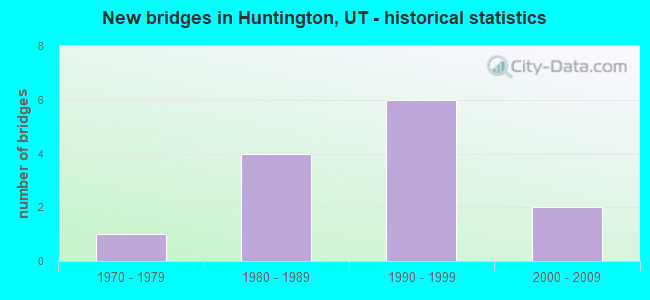
- New bridges - historical statistics
- 11970-1979
- 41980-1989
- 61990-1999
- 22000-2009

- Reconstructed bridges - Historical Statistics
- 11980-1989
- 01990-1999
- 02000-2009
- 12010-2019


- Bridge Condition - Deck
- 50.0%Good
- 50.0%Satisfactory

- Bridge Condition - Superstructure
- 50.0%Good
- 50.0%Satisfactory

- Bridge Condition - Substructure
- 62.5%Good
- 37.5%Satisfactory

- Bridge Condition - Channel
- 8.3%Very good
- 58.3%Good
- 25.0%Satisfactory
- 8.3%Poor

- Bridge Condition - Culverts
- 20.0%Very good
- 60.0%Good
- 20.0%Satisfactory
Find on map >> Show street view
Structure Number: 15008F, Location: 400 E.400 N.-HUNTINGTON (Lat: 39.335197, Lng: -110.956525), Route carried "on" structure: City street , Year Built: 1993, Status: Open, Structure Length: 2.01m (6.59ft), Average Daily Traffic: 126 (year 2020), Truck Traffic: 1%, Average Future Daily Traffic: 153 (year 2040), Design Load: HS 20+Mod, Features Intersected: HUNTINGTON CREEK, Facility Carried by Structure: CITY ST.-400 E.ST.
Minimum Vertical Clearance: 30+ m (98+ ft), Kilometerpoint: 0.000, Lanes on structure: 2, Owner: City or Municipal Highway Agency, Approaching Roadway Width: 9.9m (32.5ft), Material/Design: Prestressed concrete, Design/Construction: Tee Beam, Number Of Spans In Main Unit: 1, Length of Maximum Span: 19.8m (65.0ft), Curb-To-Curb Width: 9.9m (32.5ft), Out-to-Out Width: 10.9m (35.8ft)
Condition: Deck: Good, Superstructure: Good, Substructure: Satisfactory, Channel: Poor, Operating Rating: 32.4 metric tons, Method Used To Determine Operating Rating: Load and Resistance Factor Rating (LRFR) rating reported by rating factor(RF) method using HL-93 loadings, Inventory Rating: 22.7 metric tons, Method Used To Determine Inventory Rating: Load Factor (LF) rating reported by rating factor (RF) method using MS18 loading, Structural Evaluation: Equal to present minimum criteria, Deck Geometry: Better than present minimum criteria, Waterway Adequacy: Meets minimum limits, Approach Roadway Alignment: Equal to present desirable criteria, Designated Inspection Frequency: Every 22 months, Inspection Date: August 2020, Deck Structure Type: Concrete Precast Panels, Wearing Surface/Protective System: Wearing Surface: Bituminous, Deck Protection: Epoxy Coated Reinforcing
Find on map >> Show street view
Structure Number: 15018C, Location: 4 MILES SO.OF HUNTINGTON (Lat: 39.270817, Lng: -110.932539), Route carried "on" structure: County highway , Year Built: 1985, Status: Posted for load, Structure Length: 1.72m (5.64ft), Average Daily Traffic: 63 (year 2020), Average Future Daily Traffic: 77 (year 2040), Design Load: HS 20+Mod, Features Intersected: HUNTINGTON CREEK, Facility Carried by Structure: COUNTY ROAD
Minimum Vertical Clearance: 30+ m (98+ ft), Kilometerpoint: 0.089, Lanes on structure: 2, Owner: County Highway Agency, Approaching Roadway Width: 6.2m (20.3ft), Material/Design: Steel, Design/Construction: Stringer/Multi-beam, Number Of Spans In Main Unit: 1, Length of Maximum Span: 15.8m (51.8ft), Curb-To-Curb Width: 6.2m (20.3ft), Out-to-Out Width: 6.5m (21.3ft)
Condition: Deck: Satisfactory, Superstructure: Satisfactory, Substructure: Good, Channel: Good, Operating Rating: 25.3 metric tons, Method Used To Determine Operating Rating: Load Factor (LF) rating reported by rating factor (RF) method using MS18 loading, Inventory Rating: 14.9 metric tons, Method Used To Determine Inventory Rating: Load Factor (LF) rating reported by rating factor (RF) method using MS18 loading, Structural Evaluation: Meets minimum limits, Deck Geometry: Somewhat better than minimum adequacy, Waterway Adequacy: Equal to present minimum criteria, Approach Roadway Alignment: Meets minimum limits, Bridge Posting: Required (Relationship of Operating Rating to Maximum Legal Load: 20.0 - 29.9% below), Designated Inspection Frequency: Every 22 months, Inspection Date: August 2020, Deck Structure Type: Corrugated Steel, Wearing Surface/Protective System: Wearing Surface: Bituminous
Find on map >> Show street view
Structure Number: 15019D, Location: SOUTHWEST OF HUNTINGTON (Lat: 39.319164, Lng: -110.991922), Route carried "on" structure: County highway , Year Built: 2002, Status: Open, Structure Length: 0.77m (2.53ft), Average Daily Traffic: 126 (year 2020), Truck Traffic: 5%, Average Future Daily Traffic: 153 (year 2040), Design Load: HS 20+Mod, Features Intersected: HUNTINGTON CANAL, Facility Carried by Structure: COUNTY ROAD
Minimum Vertical Clearance: 30+ m (98+ ft), Kilometerpoint: 0.020, Lanes on structure: 2, Owner: County Highway Agency, Approaching Roadway Width: 7.1m (23.3ft), Material/Design: Prestressed concrete, Design/Construction: Frame, Number Of Spans In Main Unit: 1, Length of Maximum Span: 6.1m (20.0ft), Curb-To-Curb Width: 7.1m (23.3ft), Out-to-Out Width: 7.6m (24.9ft)
Condition: Deck: Good, Superstructure: Good, Substructure: Good, Channel: Good, Operating Rating: 32.4 metric tons, Method Used To Determine Operating Rating: Load and Resistance Factor Rating (LRFR) rating reported by rating factor(RF) method using HL-93 loadings, Inventory Rating: 19.4 metric tons, Method Used To Determine Inventory Rating: Load Factor (LF) rating reported by rating factor (RF) method using MS18 loading, Structural Evaluation: Somewhat better than minimum adequacy, Deck Geometry: Meets minimum limits, Waterway Adequacy: Equal to present desirable criteria, Approach Roadway Alignment: Equal to present desirable criteria, Designated Inspection Frequency: Every 22 months, Inspection Date: August 2020, Deck Structure Type: Concrete Precast Panels, Wearing Surface/Protective System: Wearing Surface: Gravel
Find on map >> Show street view
Structure Number: 15020E, Location: 0.5 MILE EAST OF LAWRENCE (Lat: 39.297458, Lng: -110.913311), Route carried "on" structure: County highway 1620, Year Built: 1985, Status: Open, Structure Length: 0.79m (2.59ft), Average Daily Traffic: 180 (year 2020), Truck Traffic: 5%, Average Future Daily Traffic: 225 (year 2040), Design Load: HS 20+Mod, Features Intersected: HUNTINGTON CREEK, Facility Carried by Structure: COUNTY ROAD
Minimum Vertical Clearance: 30+ m (98+ ft), Kilometerpoint: 19.929, Lanes on structure: 2, Owner: County Highway Agency, Approaching Roadway Width: 7.3m (24.0ft), Material/Design: Concrete continuous, Design/Construction: Culvert, Number Of Spans In Main Unit: 2, Length of Maximum Span: 3.7m (12.1ft)
Condition: Channel: Satisfactory, Culverts: Good, Operating Rating: 32.4 metric tons, Method Used To Determine Operating Rating: Load and Resistance Factor Rating (LRFR) rating reported by rating factor(RF) method using HL-93 loadings, Inventory Rating: 17.5 metric tons, Method Used To Determine Inventory Rating: Load Factor (LF) rating reported by rating factor (RF) method using MS18 loading, Structural Evaluation: Somewhat better than minimum adequacy, Waterway Adequacy: Equal to present minimum criteria, Approach Roadway Alignment: Equal to present desirable criteria, Designated Inspection Frequency: Every 22 months, Inspection Date: August 2020
Find on map >> Show street view
Structure Number: 15027C, Location: 4 MILES NW.OF HUNTINGTON (Lat: 39.357703, Lng: -111.030200), Route carried "on" structure: County highway , Year Built: 1985, Year Reconstructed: 2015, Status: Posted for load, Structure Length: 1.65m (5.41ft), Average Daily Traffic: 113 (year 2020), Average Future Daily Traffic: 138 (year 2040), Design Load: HS 20+Mod, Features Intersected: HUNTINGTON CREEK, Facility Carried by Structure: COUNTY ROAD
Minimum Vertical Clearance: 30+ m (98+ ft), Kilometerpoint: 0.861, Lanes on structure: 2, Owner: County Highway Agency, Approaching Roadway Width: 7.7m (25.3ft), Material/Design: Steel, Design/Construction: Stringer/Multi-beam, Number Of Spans In Main Unit: 1, Length of Maximum Span: 13.2m (43.3ft), Curb-To-Curb Width: 7.7m (25.3ft), Out-to-Out Width: 7.9m (25.9ft)
Condition: Deck: Good, Superstructure: Satisfactory, Substructure: Good, Channel: Very good, Operating Rating: 24.9 metric tons, Method Used To Determine Operating Rating: Load Factor (LF) rating reported by rating factor (RF) method using MS18 loading, Inventory Rating: 16.8 metric tons, Method Used To Determine Inventory Rating: Load Factor (LF) rating reported by rating factor (RF) method using MS18 loading, Structural Evaluation: Somewhat better than minimum adequacy, Deck Geometry: Somewhat better than minimum adequacy, Waterway Adequacy: Equal to present minimum criteria, Approach Roadway Alignment: Equal to present desirable criteria, Bridge Posting: Required (Relationship of Operating Rating to Maximum Legal Load: 20.0 - 29.9% below), Designated Inspection Frequency: Every 22 months, Inspection Date: August 2020, Deck Structure Type: Corrugated Steel, Wearing Surface/Protective System: Wearing Surface: Bituminous
Find on map >> Show street view
Structure Number: 15029C, Location: 0.5 MI.NO.OF HUNTINGTON (Lat: 39.343294, Lng: -110.969367), Route carried "on" structure: County highway , Year Built: 1985, Status: Open, Structure Length: 1.22m (4.00ft), Average Daily Traffic: 214 (year 2020), Truck Traffic: 1%, Average Future Daily Traffic: 260 (year 2040), Design Load: HS 20+Mod, Features Intersected: HUNTINGTON CREEK, Facility Carried by Structure: COUNTY ROAD
Minimum Vertical Clearance: 30+ m (98+ ft), Kilometerpoint: 0.041, Lanes on structure: 2, Owner: County Highway Agency, Approaching Roadway Width: 8.4m (27.6ft), Material/Design: Steel, Design/Construction: Stringer/Multi-beam, Number Of Spans In Main Unit: 1, Length of Maximum Span: 12.0m (39.4ft), Curb-To-Curb Width: 8.4m (27.6ft), Out-to-Out Width: 8.6m (28.2ft)
Condition: Deck: Satisfactory, Superstructure: Satisfactory, Substructure: Satisfactory, Channel: Good, Operating Rating: 36.9 metric tons, Method Used To Determine Operating Rating: Load and Resistance Factor Rating (LRFR) rating reported by rating factor(RF) method using HL-93 loadings, Inventory Rating: 33.7 metric tons, Method Used To Determine Inventory Rating: Load Factor (LF) rating reported by rating factor (RF) method using MS18 loading, Structural Evaluation: Equal to present minimum criteria, Deck Geometry: Somewhat better than minimum adequacy, Waterway Adequacy: Equal to present minimum criteria, Approach Roadway Alignment: Equal to present desirable criteria, Designated Inspection Frequency: Every 22 months, Inspection Date: August 2020, Deck Structure Type: Corrugated Steel, Wearing Surface/Protective System: Wearing Surface: Bituminous
Find on map >> Show street view
Structure Number: 15039D, Location: 3 MILES SE. OF HUNTINGTON (Lat: 39.278700, Lng: -110.935800), Route carried "on" structure: County highway 1622, Year Built: 1992, Status: Open, Structure Length: 0.79m (2.59ft), Average Daily Traffic: 268 (year 2020), Average Future Daily Traffic: 335 (year 2040), Design Load: HL 93, Features Intersected: GUYMON WASH, Facility Carried by Structure: COUNTY ROAD
Minimum Vertical Clearance: 30+ m (98+ ft), Kilometerpoint: 6.352, Lanes on structure: 2, Owner: County Highway Agency, Approaching Roadway Width: 9.1m (29.9ft), Material/Design: Concrete, Design/Construction: Frame, Number Of Spans In Main Unit: 1, Length of Maximum Span: 7.2m (23.6ft), Curb-To-Curb Width: 9.1m (29.9ft), Out-to-Out Width: 20.7m (67.9ft)
Condition: Deck: Satisfactory, Superstructure: Satisfactory, Substructure: Satisfactory, Channel: Satisfactory, Operating Rating: 58.0 metric tons, Method Used To Determine Operating Rating: Load and Resistance Factor Rating (LRFR) rating reported by rating factor(RF) method using HL-93 loadings, Inventory Rating: 32.4 metric tons, Method Used To Determine Inventory Rating: Load Factor (LF) rating reported by rating factor (RF) method using MS18 loading, Structural Evaluation: Equal to present minimum criteria, Deck Geometry: Equal to present minimum criteria, Waterway Adequacy: Equal to present minimum criteria, Approach Roadway Alignment: Equal to present desirable criteria, Designated Inspection Frequency: Every 22 months, Inspection Date: August 2020, Deck Structure Type: Concrete Precast Panels, Wearing Surface/Protective System: Wearing Surface: Bituminous
Find on map >> Show street view
Structure Number: D 803, Location: 3.3 MI.WEST OF HUNTINGTON (Lat: 39.355069, Lng: -111.024664), Route carried "on" structure: State highway 31, Year Built: 1973, Year Reconstructed: 1993, Status: Open, Structure Length: 0.82m (2.69ft), Average Daily Traffic: 6,921 (year 2020), Truck Traffic: 39%, Average Future Daily Traffic: 8,651 (year 2040), Design Load: HS 20+Mod, Features Intersected: CLEVELAND CANAL
Minimum Vertical Clearance: 30+ m (98+ ft), Kilometerpoint: 71.063, Lanes on structure: 2, Owner: State Highway Agency, Approaching Roadway Width: 12.2m (40.0ft), Skew: 3 degrees, Material/Design: Concrete, Design/Construction: Slab, Number Of Spans In Main Unit: 1, Length of Maximum Span: 7.7m (25.3ft), Curb-To-Curb Width: 12.2m (40.0ft), Out-to-Out Width: 13.3m (43.6ft)
Condition: Deck: Good, Superstructure: Good, Substructure: Good, Operating Rating: 77.4 metric tons, Method Used To Determine Operating Rating: Load and Resistance Factor Rating (LRFR) rating reported by rating factor(RF) method using HL-93 loadings, Inventory Rating: 59.6 metric tons, Method Used To Determine Inventory Rating: Load Factor (LF) rating reported by rating factor (RF) method using MS18 loading, Structural Evaluation: Better than present minimum criteria, Deck Geometry: Somewhat better than minimum adequacy, Waterway Adequacy: High priority of corrective action, Approach Roadway Alignment: Equal to present desirable criteria, Designated Inspection Frequency: Every 24 months, Inspection Date: August 2021, Deck Structure Type: Concrete Cast-file-Place, Wearing Surface/Protective System: Wearing Surface: Bituminous, Membrane: Preformed Fabric
Find on map >> Show street view
Structure Number: E2377, Location: 3.0 MI. W. of HUNTINGTON (Lat: 39.357697, Lng: -111.029542), Route carried "on" structure: State highway 31, Year Built: 1993, Status: Open, Structure Length: 0.90m (2.95ft), Average Daily Traffic: 6,921 (year 2020), Truck Traffic: 39%, Average Future Daily Traffic: 8,651 (year 2040), Design Load: HS 20+Mod, Features Intersected: BROCKBANK HOLLOW WASH
Minimum Vertical Clearance: 30+ m (98+ ft), Kilometerpoint: 70.533, Lanes on structure: 2, Owner: State Highway Agency, Approaching Roadway Width: 12.2m (40.0ft), Skew: 2 degrees, Material/Design: Concrete, Design/Construction: Culvert, Number Of Spans In Main Unit: 2, Length of Maximum Span: 4.0m (13.1ft)
Condition: Channel: Good, Culverts: Very good, Operating Rating: 47.3 metric tons, Method Used To Determine Operating Rating: Load and Resistance Factor Rating (LRFR) rating reported by rating factor(RF) method using HL-93 loadings, Inventory Rating: 33.7 metric tons, Method Used To Determine Inventory Rating: Load and Resistance Factor Rating (LRFR) rating reported by rating factor(RF) method using HL-93 loadings, Structural Evaluation: Equal to present desirable criteria, Waterway Adequacy: Equal to present desirable criteria, Approach Roadway Alignment: Equal to present desirable criteria, Designated Inspection Frequency: Every 24 months, Inspection Date: August 2021
Find on map >> Show street view
Structure Number: E2411, Location: NORTH END OF HUNTINGTON (Lat: 39.338692, Lng: -110.961906), Route carried "on" structure: State highway 10, Year Built: 1996, Status: Open, Structure Length: 1.56m (5.12ft), Average Daily Traffic: 8,684 (year 2020), Truck Traffic: 30%, Average Future Daily Traffic: 10,855 (year 2040), Design Load: HS 20+Mod, Features Intersected: HUNTINGTON CREEK
Minimum Vertical Clearance: 30+ m (98+ ft), Kilometerpoint: 77.207, Lanes on structure: 4, Owner: State Highway Agency, Approaching Roadway Width: 24.4m (80.1ft), Skew: 20 degrees, Material/Design: Concrete continuous, Design/Construction: Culvert, Number Of Spans In Main Unit: 3, Length of Maximum Span: 4.9m (16.1ft)
Condition: Channel: Good, Culverts: Good, Operating Rating: 63.2 metric tons, Method Used To Determine Operating Rating: Load and Resistance Factor Rating (LRFR) rating reported by rating factor(RF) method using HL-93 loadings, Inventory Rating: 46.0 metric tons, Method Used To Determine Inventory Rating: Load and Resistance Factor Rating (LRFR) rating reported by rating factor(RF) method using HL-93 loadings, Structural Evaluation: Better than present minimum criteria, Waterway Adequacy: Equal to present desirable criteria, Approach Roadway Alignment: Equal to present desirable criteria, Designated Inspection Frequency: Every 24 months, Inspection Date: August 2021
Find on map >> Show street view
Structure Number: E2424, Location: 1 MI.EAST JCT.WITH SR-10 (Lat: 39.344972, Lng: -110.926111), Route carried "on" structure: State highway 155, Year Built: 1997, Status: Open, Structure Length: 0.73m (2.40ft), Average Daily Traffic: 1,854 (year 2020), Truck Traffic: 25%, Average Future Daily Traffic: 2,318 (year 2040), Design Load: HS 20+Mod, Features Intersected: CEDAR CREEK
Minimum Vertical Clearance: 30+ m (98+ ft), Kilometerpoint: 1.097, Lanes on structure: 2, Owner: State Highway Agency, Approaching Roadway Width: 13.7m (44.9ft), Skew: 2 degrees, Material/Design: Concrete, Design/Construction: Culvert, Number Of Spans In Main Unit: 1, Length of Maximum Span: 6.6m (21.7ft)
Condition: Channel: Satisfactory, Culverts: Good, Operating Rating: 69.0 metric tons, Method Used To Determine Operating Rating: Load and Resistance Factor Rating (LRFR) rating reported by rating factor(RF) method using HL-93 loadings, Inventory Rating: 63.5 metric tons, Method Used To Determine Inventory Rating: Load Factor (LF) rating reported by rating factor (RF) method using MS18 loading, Structural Evaluation: Better than present minimum criteria, Waterway Adequacy: Equal to present minimum criteria, Approach Roadway Alignment: Equal to present desirable criteria, Designated Inspection Frequency: Every 24 months, Inspection Date: August 2021
Find on map >> Show street view
Structure Number: E2502, Location: North of Huntington (Lat: 39.360583, Lng: -110.925933), Route carried "on" structure: State highway 10, Year Built: 2003, Status: Open, Structure Length: 0.93m (3.05ft), Average Daily Traffic: 4,468 (year 2020), Truck Traffic: 24%, Average Future Daily Traffic: 5,585 (year 2040), Design Load: HS 20+Mod, Features Intersected: CEDAR CREEK
Minimum Vertical Clearance: 30+ m (98+ ft), Kilometerpoint: 81.588, Lanes on structure: 4, Owner: State Highway Agency, Approaching Roadway Width: 26.5m (86.9ft), Skew: 4 degrees, Material/Design: Concrete continuous, Design/Construction: Culvert, Number Of Spans In Main Unit: 1, Length of Maximum Span: 3.9m (12.8ft)
Condition: Channel: Good, Culverts: Satisfactory, Operating Rating: 97.2 metric tons, Method Used To Determine Operating Rating: Load and Resistance Factor Rating (LRFR) rating reported by rating factor(RF) method using HL-93 loadings, Inventory Rating: 72.6 metric tons, Method Used To Determine Inventory Rating: Load and Resistance Factor Rating (LRFR) rating reported by rating factor(RF) method using HL-93 loadings, Structural Evaluation: Equal to present minimum criteria, Waterway Adequacy: Better than present minimum criteria, Approach Roadway Alignment: Equal to present desirable criteria, Designated Inspection Frequency: Every 24 months, Inspection Date: August 2021
Find on map >> Show street view
Structure Number: F 567, Location: 1.7 MI.WEST OF HUNTINGTON (Lat: 39.346592, Lng: -110.991897), Route carried "on" structure: State highway 31, Year Built: 1993, Status: Open, Structure Length: 2.73m (8.96ft), Average Daily Traffic: 6,921 (year 2020), Truck Traffic: 39%, Average Future Daily Traffic: 8,651 (year 2040), Design Load: HS 20+Mod, Features Intersected: HUNTINGTON CREEK
Minimum Vertical Clearance: 30+ m (98+ ft), Kilometerpoint: 74.070, Lanes on structure: 2, Owner: State Highway Agency, Approaching Roadway Width: 12.2m (40.0ft), Material/Design: Prestressed concrete, Design/Construction: Stringer/Multi-beam, Number Of Spans In Main Unit: 1, Length of Maximum Span: 26.5m (86.9ft), Curb-To-Curb Width: 12.2m (40.0ft), Out-to-Out Width: 13.2m (43.3ft)
Condition: Deck: Satisfactory, Superstructure: Good, Substructure: Good, Channel: Good, Operating Rating: 44.4 metric tons, Method Used To Determine Operating Rating: Load and Resistance Factor Rating (LRFR) rating reported by rating factor(RF) method using HL-93 loadings, Inventory Rating: 38.9 metric tons, Method Used To Determine Inventory Rating: Load Factor (LF) rating reported by rating factor (RF) method using MS18 loading, Structural Evaluation: Better than present minimum criteria, Deck Geometry: Somewhat better than minimum adequacy, Waterway Adequacy: Better than present minimum criteria, Approach Roadway Alignment: Equal to present desirable criteria, Designated Inspection Frequency: Every 24 months, Inspection Date: August 2021, Deck Structure Type: Concrete Cast-file-Place, Wearing Surface/Protective System: Wearing Surface: Monolithic Concrete, Deck Protection: Epoxy Coated Reinforcing