Bridge Statistics for Huntington, Virginia (VA)
Condition, Traffic, Stress, Structural Evaluation, Project Costs
- National Bridge Inventory (NBI) Statistics
- 14Number of bridges
- 663ft / 202mTotal length
- $3,000Total costs
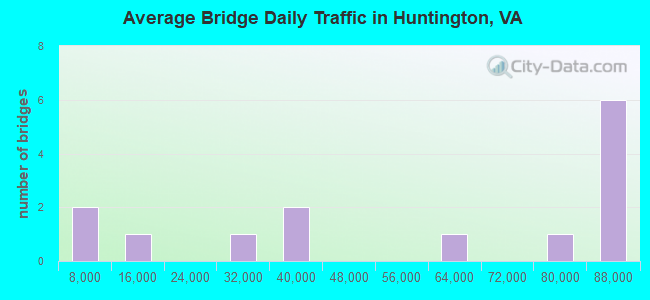
- 762,525Total average daily traffic
- 63,579Total average daily truck traffic
- National Bridge Inventory (NBI) Registered Bridges for Huntington
- No street view available for this location
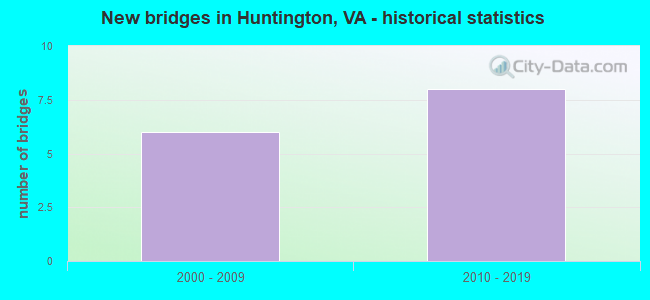
- New bridges - historical statistics
- 62000-2009
- 82010-2019
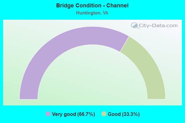
- Bridge Condition - Channel
- 66.7%Very good
- 33.3%Good
Find on map >> Show street view
Structure Number: 26436, Location: 00.15fr 1 & 0.18to Eisen (Lat: 38.799267, Lng: -77.075472), Route carried "on" structure: Ramp Interstate 95, Year Built: 2010, Status: Open, Structure Length: 52.91m (173.59ft), Average Daily Traffic: 72,045 (year 2018), Truck Traffic: 6%, Average Future Daily Traffic: 35,000 (year 2030), Design Load: HS 20, Features Intersected: RMPS E;G & I-95 & CONN, Facility Carried by Structure: Ramps A-1 and A-2
Minimum Vertical Clearance: 30+ m (98+ ft), Kilometerpoint: 0.000, Lanes on structure: 2, Lanes under structure: 17, Base Highway Network: Yes, Owner: State Highway Agency, Approaching Roadway Width: 10.1m (33.1ft), Material/Design: Steel continuous, Design/Construction: Stringer/Multi-beam, Number Of Spans In Main Unit: 17, Length of Maximum Span: 45.5m (149.3ft), Curb-To-Curb Width: 7.3m (24.0ft), Out-to-Out Width: 14.0m (45.9ft)
Condition: Deck: Good, Superstructure: Good, Substructure: Good, Operating Rating: 56.8 metric tons, Method Used To Determine Operating Rating: Load and Resistance Factor (LRFR), Inventory Rating: 43.7 metric tons, Method Used To Determine Inventory Rating: Load and Resistance Factor (LRFR), Structural Evaluation: Better than present minimum criteria, Deck Geometry: High priority of replacement, Underclear: High priority of corrective action, Approach Roadway Alignment: Equal to present desirable criteria, Designated Inspection Frequency: Every 24 months, Inspection Date: June 2020, Deck Structure Type: Concrete Cast-file-Place, Wearing Surface/Protective System: Wearing Surface: Monolithic Concrete, Deck Protection: Epoxy Coated Reinforcing
Find on map >> Show street view
Structure Number: 27078, Location: 2.40FR EISEN/0.20TO RTE.1 (Lat: 38.798261, Lng: -77.069650), Route carried "on" structure: Ramp Interstate 95, Year Built: 2005, Status: Open, Structure Length: 97.08m (318.50ft), Average Daily Traffic: 57,638 (year 2020), Truck Traffic: 6%, Average Future Daily Traffic: 80,693 (year 2040), Design Load: HS 20+Mod, Features Intersected: CAMERON RUN
Minimum Vertical Clearance: 5.58m (18.31ft), Kilometerpoint: 0.000, Lanes on structure: 4, Base Highway Network: Yes, Owner: State Highway Agency, Approaching Roadway Width: 17.7m (58.1ft), Material/Design: Prestressed concrete continuous, Design/Construction: Stringer/Multi-beam, Number Of Spans In Main Unit: 53, Length of Maximum Span: 18.3m (60.0ft), Curb-To-Curb Width: 17.8m (58.4ft), Out-to-Out Width: 18.7m (61.4ft)
Condition: Deck: Good, Superstructure: Good, Substructure: Good, Channel: Very good, Operating Rating: 48.1 metric tons, Method Used To Determine Operating Rating: Load and Resistance Factor (LRFR), Inventory Rating: 37.1 metric tons, Method Used To Determine Inventory Rating: Load and Resistance Factor (LRFR), Structural Evaluation: Better than present minimum criteria, Deck Geometry: Better than present minimum criteria, Waterway Adequacy: Equal to present desirable criteria, Approach Roadway Alignment: Equal to present desirable criteria, Designated Inspection Frequency: Every 24 months, Underwater Inspection Frequency: Every 60 months, Inspection Date: April 2021, Underwater Inspection Date: July 2021, Deck Structure Type: Concrete Cast-file-Place, Wearing Surface/Protective System: Wearing Surface: Monolithic Concrete, Membrane: Built-up, Deck Protection: Epoxy Coated Reinforcing
Find on map >> Show street view
Structure Number: 27087, Location: 00.25FR1/00.10TOI95NB (Lat: 38.792858, Lng: -77.058675), Route carried "on" structure: Ramp Interstate 1, Year Built: 2005, Status: Open, Structure Length: 31.24m (102.49ft), Average Daily Traffic: 9,871 (year 2020), Truck Traffic: 1%, Average Future Daily Traffic: 13,819 (year 2040), Design Load: HS 20, Features Intersected: CAMERON RUN AND RAMP F
Minimum Vertical Clearance: 5.72m (18.77ft), Kilometerpoint: 0.000, Lanes on structure: 1, Lanes under structure: 2, Base Highway Network: Yes, Owner: State Highway Agency, Approaching Roadway Width: 7.9m (25.9ft), Material/Design: Steel continuous, Design/Construction: Stringer/Multi-beam, Number Of Spans In Main Unit: 6, Number Of Approach Spans: 6, Length of Maximum Span: 40.2m (131.9ft), Curb-To-Curb Width: 7.9m (25.9ft), Out-to-Out Width: 10.1m (33.1ft)
Condition: Deck: Good, Superstructure: Good, Substructure: Good, Channel: Good, Operating Rating: 73.1 metric tons, Method Used To Determine Operating Rating: Load and Resistance Factor (LRFR), Inventory Rating: 56.5 metric tons, Method Used To Determine Inventory Rating: Load and Resistance Factor (LRFR), Structural Evaluation: Better than present minimum criteria, Deck Geometry: Equal to present desirable criteria, Waterway Adequacy: Equal to present desirable criteria, Approach Roadway Alignment: Equal to present desirable criteria, Length Of Structure Improvement: 0.30m (0.98ft), Designated Inspection Frequency: Every 24 months, Underwater Inspection Frequency: Every 60 months, Inspection Date: April 2020, Underwater Inspection Date: April 2017, Bridge Improvement Cost: $1,000, Roadway Improvement Cost: $1,000, Total Project Cost: $3,000, Deck Structure Type: Concrete Cast-file-Place, Wearing Surface/Protective System: Wearing Surface: Monolithic Concrete, Deck Protection: Epoxy Coated Reinforcing
Find on map >> Show street view
Structure Number: 27088, Location: 00.25FR1/00.20TO95NB (Lat: 38.792742, Lng: -77.058717), Route carried "on" structure: Ramp Interstate 1, Year Built: 2006, Status: Open, Structure Length: 20.36m (66.80ft), Average Daily Traffic: 5,971 (year 2020), Truck Traffic: 4%, Average Future Daily Traffic: 8,359 (year 2040), Design Load: HS 20, Features Intersected: CAMERON RUN;I-95N &RAMPF
Minimum Vertical Clearance: 30.18m (99.02ft), Kilometerpoint: 0.000, Lanes on structure: 1, Lanes under structure: 4, Base Highway Network: Yes, Owner: State Highway Agency, Approaching Roadway Width: 11.3m (37.1ft), Material/Design: Steel continuous, Design/Construction: Stringer/Multi-beam, Number Of Spans In Main Unit: 5, Length of Maximum Span: 41.8m (137.1ft), Curb-To-Curb Width: 11.3m (37.1ft), Out-to-Out Width: 12.2m (40.0ft)
Condition: Deck: Good, Superstructure: Good, Substructure: Good, Channel: Very good, Operating Rating: 44.1 metric tons, Method Used To Determine Operating Rating: Load and Resistance Factor (LRFR), Inventory Rating: 33.9 metric tons, Method Used To Determine Inventory Rating: Load and Resistance Factor (LRFR), Structural Evaluation: Better than present minimum criteria, Deck Geometry: Superior to present desirable criteria, Underclear: Meets minimum limits, Waterway Adequacy: Equal to present desirable criteria, Approach Roadway Alignment: Equal to present minimum criteria, Designated Inspection Frequency: Every 24 months, Underwater Inspection Frequency: Every 60 months, Inspection Date: June 2021, Underwater Inspection Date: July 2021, Deck Structure Type: Concrete Cast-file-Place, Wearing Surface/Protective System: Wearing Surface: Monolithic Concrete, Deck Protection: Epoxy Coated Reinforcing
Find on map >> Show street view
Structure Number: 26436, Location: 00.15fr 1 & 0.18to Eisen (Lat: 38.799267, Lng: -77.075472), Route carried "under" structure: Interstate 95, Year Built: 2010, Structure Length: 0. m, Average Daily Traffic: 87,200 (year 2010), Truck Traffic: 10%, Features Intersected: RMPS E;G & I-95 & CONN, Facility Carried by Structure: Ramps A-1 and A-2
Minimum Vertical Clearance: 7.57m (24.84ft), Kilometerpoint: 0.000, Lanes on structure: 2, Lanes under structure: 2, Material/Design: Steel continuous, Design/Construction: Stringer/Multi-beam, Length of Maximum Span: 45.5m (149.3ft)
Find on map >> Show street view
Structure Number: 26436, Location: 00.15fr 1 & 0.18to Eisen (Lat: 38.799267, Lng: -77.075472), Route carried "under" structure: Ramp Interstate 95, Year Built: 2010, Structure Length: 0. m, Average Daily Traffic: 38,000 (year 2010), Truck Traffic: 6%, Features Intersected: RMPS E;G & I-95 & CONN, Facility Carried by Structure: Ramps A-1 and A-2
Minimum Vertical Clearance: 9.22m (30.25ft), Kilometerpoint: 0.000, Lanes on structure: 2, Lanes under structure: 2, Material/Design: Steel continuous, Design/Construction: Stringer/Multi-beam, Length of Maximum Span: 45.5m (149.3ft)
Find on map >> Show street view
Structure Number: 26436, Location: 00.15fr 1 & 0.18to Eisen (Lat: 38.799267, Lng: -77.075472), Route carried "under" structure: Interstate 95, Year Built: 2010, Structure Length: 0. m, Average Daily Traffic: 84,500 (year 2010), Truck Traffic: 10%, Features Intersected: RMPS E;G & I-95 & CONN, Facility Carried by Structure: Ramps A-1 and A-2
Minimum Vertical Clearance: 8.76m (28.74ft), Kilometerpoint: 0.000, Lanes on structure: 2, Lanes under structure: 2, Material/Design: Steel continuous, Design/Construction: Stringer/Multi-beam, Length of Maximum Span: 45.5m (149.3ft)
Find on map >> Show street view
Structure Number: 26436, Location: 00.15fr 1 & 0.18to Eisen (Lat: 38.799267, Lng: -77.075472), Route carried "under" structure: Interstate 95, Year Built: 2010, Structure Length: 0. m, Average Daily Traffic: 87,400 (year 2010), Truck Traffic: 10%, Features Intersected: RMPS E;G & I-95 & CONN, Facility Carried by Structure: Ramps A-1 and A-2
Minimum Vertical Clearance: 8.58m (28.15ft), Kilometerpoint: 0.000, Lanes on structure: 2, Lanes under structure: 2, Material/Design: Steel continuous, Design/Construction: Stringer/Multi-beam, Length of Maximum Span: 45.5m (149.3ft)
Find on map >> Show street view
Structure Number: 26436, Location: 00.15fr 1 & 0.18to Eisen (Lat: 38.799267, Lng: -77.075472), Route carried "under" structure: Interstate 95, Year Built: 2010, Structure Length: 0. m, Average Daily Traffic: 83,400 (year 2010), Truck Traffic: 10%, Features Intersected: RMPS E;G & I-95 & CONN, Facility Carried by Structure: Ramps A-1 and A-2
Minimum Vertical Clearance: 6.93m (22.74ft), Kilometerpoint: 0.000, Lanes on structure: 2, Lanes under structure: 3, Material/Design: Steel continuous, Design/Construction: Stringer/Multi-beam, Length of Maximum Span: 45.5m (149.3ft)
Find on map >> Show street view
Structure Number: 26436, Location: 00.15fr 1 & 0.18to Eisen (Lat: 38.799267, Lng: -77.075472), Route carried "under" structure: Ramp Interstate 95, Year Built: 2010, Structure Length: 0. m, Average Daily Traffic: 38,400 (year 2010), Truck Traffic: 8%, Features Intersected: RMPS E;G & I-95 & CONN, Facility Carried by Structure: Ramps A-1 and A-2
Minimum Vertical Clearance: 5.72m (18.77ft), Kilometerpoint: 0.000, Lanes on structure: 2, Lanes under structure: 2, Material/Design: Steel continuous, Design/Construction: Stringer/Multi-beam, Length of Maximum Span: 45.5m (149.3ft)
Find on map >> Show street view
Structure Number: 26436, Location: 00.15fr 1 & 0.18to Eisen (Lat: 38.799267, Lng: -77.075472), Route carried "under" structure: ServiceOther road , Year Built: 2010, Structure Length: 0. m, Average Daily Traffic: 100 (year 2010), Truck Traffic: 1%, Features Intersected: RMPS E;G & I-95 & CONN, Facility Carried by Structure: Ramps A-1 and A-2
Minimum Vertical Clearance: 6.35m (20.83ft), Kilometerpoint: 0.000, Lanes on structure: 2, Lanes under structure: 2, Material/Design: Steel continuous, Design/Construction: Stringer/Multi-beam, Length of Maximum Span: 45.5m (149.3ft)
Find on map >> Show street view
Structure Number: 27087, Location: 00.25FR1/00.10TOI95NB (Lat: 38.792858, Lng: -77.058675), Route carried "under" structure: Ramp Interstate 95, Year Built: 2005, Structure Length: 0. m, Average Daily Traffic: 28,000 (year 2008), Truck Traffic: 2%, Features Intersected: CAMERON RUN AND RAMP F
Minimum Vertical Clearance: 5.74m (18.83ft), Kilometerpoint: 0.000, Lanes on structure: 1, Lanes under structure: 2, Material/Design: Steel continuous, Design/Construction: Stringer/Multi-beam, Length of Maximum Span: 40.2m (131.9ft)
Find on map >> Show street view
Structure Number: 27088, Location: 00.25FR1/00.20TO95NB (Lat: 38.792742, Lng: -77.058717), Route carried "under" structure: Ramp Interstate 95, Year Built: 2006, Structure Length: 0. m, Average Daily Traffic: 85,000 (year 2011), Truck Traffic: 8%, Features Intersected: CAMERON RUN;I-95N &RAMPF
Minimum Vertical Clearance: 5.82m (19.09ft), Kilometerpoint: 0.000, Lanes on structure: 1, Lanes under structure: 2, Material/Design: Steel continuous, Design/Construction: Stringer/Multi-beam, Length of Maximum Span: 41.8m (137.1ft)
Find on map >> Show street view
Structure Number: 27088, Location: 00.25FR1/00.20TO95NB (Lat: 38.792742, Lng: -77.058717), Route carried "under" structure: Ramp Interstate 95, Year Built: 2006, Structure Length: 0. m, Average Daily Traffic: 85,000 (year 2011), Truck Traffic: 10%, Features Intersected: CAMERON RUN;I-95N &RAMPF
Minimum Vertical Clearance: 5.52m (18.11ft), Kilometerpoint: 0.000, Lanes on structure: 1, Lanes under structure: 2, Material/Design: Steel continuous, Design/Construction: Stringer/Multi-beam, Length of Maximum Span: 41.8m (137.1ft)