Bridge Statistics for Huson, Montana (MT)
Condition, Traffic, Stress, Structural Evaluation, Project Costs
- National Bridge Inventory (NBI) Statistics
- 12Number of bridges
- 394ft / 120mTotal length
- $2,481,000Total costs
- 49,762Total average daily traffic
- 11,038Total average daily truck traffic
- National Bridge Inventory (NBI) Registered Bridges for Huson
- No street view available for this location
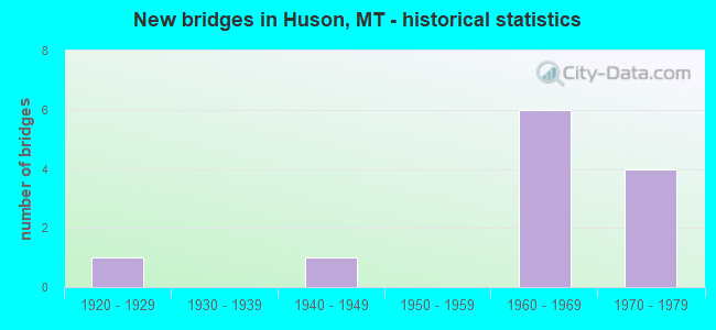
- New bridges - historical statistics
- 11920-1929
- 11940-1949
- 61960-1969
- 41970-1979

- Reconstructed bridges - Historical Statistics
- 11980-1989
- 01990-1999
- 02000-2009
- 12010-2019


- Bridge Condition - Deck
- 22.2%Good
- 66.7%Satisfactory
- 11.1%Poor

- Bridge Condition - Superstructure
- 33.3%Good
- 11.1%Satisfactory
- 44.4%Fair
- 11.1%Poor

- Bridge Condition - Substructure
- 33.3%Good
- 44.4%Satisfactory
- 11.1%Fair
- 11.1%Poor

- Bridge Condition - Channel
- 20.0%Very good
- 40.0%Good
- 40.0%Satisfactory
Find on map >> Show street view
Structure Number: I00090080+03411, Location: 5M E ALBERTON (Lat: 47.013464, Lng: -114.409100), Route carried "on" structure: Interstate 90, Year Built: 1979, Status: Open, Structure Length: 31.08m (101.97ft), Average Daily Traffic: 7,090 (year 2020), Truck Traffic: 26%, Average Future Daily Traffic: 7,445 (year 2040), Design Load: HS 20, Features Intersected: CLARK FORK RIVER
Minimum Vertical Clearance: 30+ m (98+ ft), Kilometerpoint: 127.904, Lanes on structure: 2, Base Highway Network: Yes, Owner: State Highway Agency, Approaching Roadway Width: 13.4m (44.0ft), Material/Design: Steel continuous, Design/Construction: Stringer/Multi-beam, Number Of Spans In Main Unit: 8, Length of Maximum Span: 46.3m (151.9ft), Curb-To-Curb Width: 12.6m (41.3ft), Out-to-Out Width: 13.5m (44.3ft)
Condition: Deck: Poor, Superstructure: Satisfactory, Substructure: Satisfactory, Channel: Good, Operating Rating: 71.7 metric tons, Method Used To Determine Operating Rating: Load Factor (LF), Inventory Rating: 43.5 metric tons, Method Used To Determine Inventory Rating: Load Factor (LF), Structural Evaluation: Equal to present minimum criteria, Deck Geometry: Better than present minimum criteria, Waterway Adequacy: Equal to present desirable criteria, Approach Roadway Alignment: Equal to present desirable criteria, Designated Inspection Frequency: Every 24 months, Underwater Inspection Frequency: Every 60 months, Inspection Date: April 2021, Underwater Inspection Date: October 2018, Deck Structure Type: Concrete Cast-file-Place, Wearing Surface/Protective System: Wearing Surface: Epoxy Overlay
Find on map >> Show street view
Structure Number: I00090080+03412, Location: 5M E ALBERTON (Lat: 47.013906, Lng: -114.409136), Route carried "on" structure: Interstate 90, Year Built: 1964, Status: Open, Structure Length: 26.79m (87.89ft), Average Daily Traffic: 7,090 (year 2020), Truck Traffic: 26%, Average Future Daily Traffic: 7,445 (year 2040), Design Load: HS 20, Features Intersected: CLARK FORK RIVER
Minimum Vertical Clearance: 30+ m (98+ ft), Kilometerpoint: 127.964, Lanes on structure: 2, Base Highway Network: Yes, Owner: State Highway Agency, Approaching Roadway Width: 13.4m (44.0ft), Material/Design: Steel, Design/Construction: Stringer/Multi-beam, Number Of Spans In Main Unit: 7, Length of Maximum Span: 46.3m (151.9ft), Curb or Sidewalk Widths: Left: 0.2m (0.7ft), Right: 0.2m (0.7ft), Curb-To-Curb Width: 8.5m (27.9ft), Out-to-Out Width: 9.7m (31.8ft)
Condition: Deck: Good, Superstructure: Fair, Substructure: Satisfactory, Channel: Good, Operating Rating: 59.9 metric tons, Method Used To Determine Operating Rating: Load Factor (LF), Inventory Rating: 35.4 metric tons, Method Used To Determine Inventory Rating: Load Factor (LF), Structural Evaluation: Somewhat better than minimum adequacy, Deck Geometry: High priority of corrective action, Waterway Adequacy: Equal to present desirable criteria, Approach Roadway Alignment: Equal to present desirable criteria, Length Of Structure Improvement: 26.79m (87.89ft), Designated Inspection Frequency: Every 24 months, Critical Feature Inspection Frequency: Every 24 months, Underwater Inspection Frequency: Every 60 months, Inspection Date: April 2021, Critical Feature Inspection Date: April 2021, Underwater Inspection Date: October 2018, Bridge Improvement Cost: $1,654,000, Roadway Improvement Cost: $827,000, Total Project Cost: $2,481,000, Deck Structure Type: Concrete Cast-file-Place, Wearing Surface/Protective System: Wearing Surface: Epoxy Overlay
Find on map >> Show street view
Structure Number: I00090081+08401, Location: 6.2M E ALBERTON (Lat: 47.022031, Lng: -114.383539), Route carried "on" structure: Interstate 90, Year Built: 1964, Status: Open, Structure Length: 29.92m (98.16ft), Average Daily Traffic: 7,090 (year 2020), Truck Traffic: 26%, Average Future Daily Traffic: 7,445 (year 2040), Design Load: HS 20, Features Intersected: CLARK FORK RIVER
Minimum Vertical Clearance: 30+ m (98+ ft), Kilometerpoint: 130.255, Lanes on structure: 4, Base Highway Network: Yes, Owner: State Highway Agency, Approaching Roadway Width: 23.2m (76.1ft), Skew: 32 degrees, Material/Design: Steel continuous, Design/Construction: Girder and Floorbeam System, Number Of Spans In Main Unit: 4, Number Of Approach Spans: 5, Length of Maximum Span: 48.8m (160.1ft), Curb or Sidewalk Widths: Left: 0.2m (0.7ft), Right: 0.2m (0.7ft), Curb-To-Curb Width: 17.6m (57.7ft), Out-to-Out Width: 19.4m (63.6ft)
Condition: Deck: Satisfactory, Superstructure: Poor, Substructure: Satisfactory, Channel: Satisfactory, Operating Rating: 46.3 metric tons, Method Used To Determine Operating Rating: Load Factor (LF), Inventory Rating: 28.1 metric tons, Method Used To Determine Inventory Rating: Load Factor (LF), Structural Evaluation: Meets minimum limits, Deck Geometry: Meets minimum limits, Waterway Adequacy: Superior to present desirable criteria, Approach Roadway Alignment: Equal to present desirable criteria, Designated Inspection Frequency: Every 24 months, Critical Feature Inspection Frequency: Every 24 months, Underwater Inspection Frequency: Every 60 months, Other Special Inspection Frequency: Every 48 months, Inspection Date: April 2021, Critical Feature Inspection Date: April 2021, Underwater Inspection Date: October 2018, Other Special Inspection Date: September 2020, Deck Structure Type: Concrete Cast-file-Place, Wearing Surface/Protective System: Wearing Surface: Latex Concrete
Find on map >> Show street view
Structure Number: I00090082+06231, Location: 6.8M W FRENCHTOWN (Lat: 47.019411, Lng: -114.367378), Route carried "on" structure: Interstate 90, Year Built: 1964, Status: Open, Structure Length: 3.78m (12.40ft), Average Daily Traffic: 9,138 (year 2020), Truck Traffic: 20%, Average Future Daily Traffic: 9,595 (year 2040), Design Load: HS 20, Features Intersected: INT NINE MILE
Minimum Vertical Clearance: 30+ m (98+ ft), Kilometerpoint: 131.571, Lanes on structure: 2, Lanes under structure: 2, Base Highway Network: Yes, Owner: State Highway Agency, Approaching Roadway Width: 11.6m (38.1ft), Skew: 30 degrees, Material/Design: Prestressed concrete, Design/Construction: Stringer/Multi-beam, Number Of Spans In Main Unit: 3, Length of Maximum Span: 12.5m (41.0ft), Curb-To-Curb Width: 11.4m (37.4ft), Out-to-Out Width: 11.7m (38.4ft)
Condition: Deck: Satisfactory, Superstructure: Good, Substructure: Satisfactory, Operating Rating: 42.6 metric tons, Method Used To Determine Operating Rating: Assigned rating based on Load Factor Design (LFD) reported in metric tons, Inventory Rating: 32.7 metric tons, Method Used To Determine Inventory Rating: Assigned rating based on Load Factor Design (LFD) reported in metric tons, Structural Evaluation: Equal to present minimum criteria, Deck Geometry: Somewhat better than minimum adequacy, Underclear: High priority of corrective action, Approach Roadway Alignment: Equal to present desirable criteria, Designated Inspection Frequency: Every 24 months, Inspection Date: May 2020, Deck Structure Type: Concrete Cast-file-Place, Wearing Surface/Protective System: Wearing Surface: Epoxy Overlay
Find on map >> Show street view
Structure Number: I00090082+06232, Location: 6.8M W FRENCHTOWN (Lat: 47.019508, Lng: -114.367433), Route carried "on" structure: Interstate 90, Year Built: 1964, Status: Open, Structure Length: 3.78m (12.40ft), Average Daily Traffic: 9,138 (year 2020), Truck Traffic: 20%, Average Future Daily Traffic: 9,595 (year 2040), Design Load: HS 20, Features Intersected: INT NINE MILE
Minimum Vertical Clearance: 30+ m (98+ ft), Kilometerpoint: 131.610, Lanes on structure: 2, Lanes under structure: 2, Base Highway Network: Yes, Owner: State Highway Agency, Approaching Roadway Width: 11.6m (38.1ft), Skew: 30 degrees, Material/Design: Prestressed concrete, Design/Construction: Stringer/Multi-beam, Number Of Spans In Main Unit: 3, Length of Maximum Span: 12.5m (41.0ft), Curb-To-Curb Width: 11.4m (37.4ft), Out-to-Out Width: 11.7m (38.4ft)
Condition: Deck: Satisfactory, Superstructure: Fair, Substructure: Good, Operating Rating: 53.5 metric tons, Method Used To Determine Operating Rating: Load and Resistance Factor (LRFR), Inventory Rating: 41.7 metric tons, Method Used To Determine Inventory Rating: Load and Resistance Factor (LRFR), Structural Evaluation: Somewhat better than minimum adequacy, Deck Geometry: Somewhat better than minimum adequacy, Underclear: High priority of corrective action, Approach Roadway Alignment: Equal to present desirable criteria, Designated Inspection Frequency: Every 24 months, Inspection Date: May 2020, Deck Structure Type: Concrete Cast-file-Place, Wearing Surface/Protective System: Wearing Surface: Epoxy Overlay
Find on map >> Show street view
Structure Number: L32003000+01001, Location: 8M NW FRENCHTOWN (Lat: 47.030881, Lng: -114.393350), Route carried "on" structure: County highway 32003, Year Built: 1975, Year Reconstructed: 1980, Status: Open, Structure Length: 2.65m (8.69ft), Average Daily Traffic: 446 (year 2020), Truck Traffic: 3%, Average Future Daily Traffic: 468 (year 2040), Design Load: HS 20, Features Intersected: NINEMILE CREEK 030, Facility Carried by Structure: W NINEMILE RD
Minimum Vertical Clearance: 30+ m (98+ ft), Kilometerpoint: 0.090, Lanes on structure: 2, Owner: County Highway Agency, Approaching Roadway Width: 8.5m (27.9ft), Material/Design: Prestressed concrete, Design/Construction: Tee Beam, Number Of Spans In Main Unit: 1, Length of Maximum Span: 25.9m (85.0ft), Curb-To-Curb Width: 8.6m (28.2ft), Out-to-Out Width: 9.1m (29.9ft)
Condition: Deck: Satisfactory, Superstructure: Good, Substructure: Good, Channel: Very good, Operating Rating: 49.8 metric tons, Method Used To Determine Operating Rating: Assigned rating based on Load Factor Design (LFD) reported in metric tons, Inventory Rating: 32.7 metric tons, Method Used To Determine Inventory Rating: Assigned rating based on Load Factor Design (LFD) reported in metric tons, Structural Evaluation: Better than present minimum criteria, Deck Geometry: Somewhat better than minimum adequacy, Waterway Adequacy: Equal to present desirable criteria, Approach Roadway Alignment: Equal to present desirable criteria, Designated Inspection Frequency: Every 24 months, Inspection Date: September 2021, Deck Structure Type: Concrete Precast Panels, Wearing Surface/Protective System: Wearing Surface: Bituminous
Find on map >> Show street view
Structure Number: L32166004+05001, Location: 3M W HUSON (Lat: 47.029308, Lng: -114.393556), Route carried "on" structure: ServiceState highway 81008, Year Built: 1924, Status: Open, Structure Length: 3.78m (12.40ft), Average Daily Traffic: 133 (year 2020), Truck Traffic: 3%, Average Future Daily Traffic: 140 (year 2040), Design Load: H 15, Features Intersected: NINEMILE CREEK 035, Facility Carried by Structure: HWY 10 W
Minimum Vertical Clearance: 9.14m (29.99ft), Kilometerpoint: 8.714, Lanes on structure: 2, Owner: State Highway Agency, Approaching Roadway Width: 9.1m (29.9ft), Skew: 4 degrees, Material/Design: Concrete, Design/Construction: Tee Beam, Number Of Spans In Main Unit: 3, Length of Maximum Span: 14.3m (46.9ft), Curb-To-Curb Width: 6.2m (20.3ft), Out-to-Out Width: 6.7m (22.0ft)
Condition: Deck: Satisfactory, Superstructure: Fair, Substructure: Poor, Channel: Satisfactory, Operating Rating: 62.1 metric tons, Method Used To Determine Operating Rating: Load Factor (LF), Inventory Rating: 37.1 metric tons, Method Used To Determine Inventory Rating: Load Factor (LF), Structural Evaluation: Meets minimum limits, Deck Geometry: Meets minimum limits, Waterway Adequacy: Equal to present desirable criteria, Approach Roadway Alignment: Equal to present minimum criteria, Designated Inspection Frequency: Every 24 months, Inspection Date: September 2021, Wearing Surface/Protective System: Wearing Surface: Bituminous
Find on map >> Show street view
Structure Number: L32166005+02001, Location: 3M W HUSON (Lat: 47.026039, Lng: -114.382150), Route carried "on" structure: ServiceState highway 81008, Year Built: 1947, Status: Open, Structure Length: 11.43m (37.50ft), Average Daily Traffic: 133 (year 2020), Truck Traffic: 3%, Average Future Daily Traffic: 140 (year 2040), Design Load: HS 20, Features Intersected: NINEMILE SLIDE 026, Facility Carried by Structure: HWY 10 W
Minimum Vertical Clearance: 30+ m (98+ ft), Kilometerpoint: 9.957, Lanes on structure: 2, Owner: State Highway Agency, Approaching Roadway Width: 7.9m (25.9ft), Material/Design: Wood or Timber, Design/Construction: Stringer/Multi-beam, Number Of Spans In Main Unit: 15, Length of Maximum Span: 8.2m (26.9ft), Curb-To-Curb Width: 8.9m (29.2ft), Out-to-Out Width: 8.9m (29.2ft)
Condition: Deck: Satisfactory, Superstructure: Fair, Substructure: Fair, Operating Rating: 40.8 metric tons, Method Used To Determine Operating Rating: Allowable Stress (AS), Inventory Rating: 28.1 metric tons, Method Used To Determine Inventory Rating: Allowable Stress (AS), Structural Evaluation: Somewhat better than minimum adequacy, Deck Geometry: Equal to present minimum criteria, Approach Roadway Alignment: Equal to present desirable criteria, Designated Inspection Frequency: Every 24 months, Inspection Date: July 2020, Deck Structure Type: Wood or Timber, Wearing Surface/Protective System: Wearing Surface: Bituminous
Find on map >> Show street view
Structure Number: L32168000+01901, Location: HUSON (Lat: 47.032833, Lng: -114.323258), Route carried "on" structure: ServiceCounty highway 32168, Year Built: 1971, Year Reconstructed: 2010, Status: Open, Structure Length: 6.85m (22.47ft), Average Daily Traffic: 100 (year 2022), Truck Traffic: 3%, Average Future Daily Traffic: 100 (year 2037), Design Load: HS 20, Features Intersected: INT HUSON-I 90 012, Facility Carried by Structure: HUSON RD
Minimum Vertical Clearance: 30+ m (98+ ft), Kilometerpoint: 0.288, Lanes on structure: 2, Lanes under structure: 4, Owner: State Highway Agency, Approaching Roadway Width: 10.1m (33.1ft), Material/Design: Prestressed concrete, Design/Construction: Stringer/Multi-beam, Number Of Spans In Main Unit: 4, Length of Maximum Span: 23.5m (77.1ft), Curb-To-Curb Width: 9.4m (30.8ft), Out-to-Out Width: 10.2m (33.5ft)
Condition: Deck: Good, Superstructure: Good, Substructure: Good, Operating Rating: 73.8 metric tons, Method Used To Determine Operating Rating: Load Factor (LF), Inventory Rating: 38.7 metric tons, Method Used To Determine Inventory Rating: Load Factor (LF), Structural Evaluation: Better than present minimum criteria, Deck Geometry: Better than present minimum criteria, Underclear: Equal to present minimum criteria, Approach Roadway Alignment: Equal to present desirable criteria, Designated Inspection Frequency: Every 24 months, Inspection Date: May 2021, Deck Structure Type: Concrete Cast-file-Place, Wearing Surface/Protective System: Wearing Surface: Epoxy Overlay, Deck Protection: Epoxy Coated Reinforcing
Find on map >> Show street view
Structure Number: I00090082+06231, Location: 68M W FRENCHTOWN (Lat: 47.019411, Lng: -114.367378), Route carried "under" structure: ServiceCounty highway 81008, Year Built: 1964, Structure Length: 0. m, Average Daily Traffic: 133 (year 2020), Truck Traffic: 3%, Features Intersected: INT NINE MILE, Facility Carried by Structure: I 90
Minimum Vertical Clearance: 5.01m (16.44ft), Kilometerpoint: 11.644, Lanes on structure: 2, Lanes under structure: 2, Material/Design: Prestressed concrete, Design/Construction: Stringer/Multi-beam, Length of Maximum Span: 12.5m (41.0ft)
Find on map >> Show street view
Structure Number: I00090082+06232, Location: 68M W FRENCHTOWN (Lat: 47.019508, Lng: -114.367433), Route carried "under" structure: ServiceCounty highway 81008, Year Built: 1964, Structure Length: 0. m, Average Daily Traffic: 133 (year 2020), Truck Traffic: 3%, Features Intersected: INT NINE MILE, Facility Carried by Structure: I 90
Minimum Vertical Clearance: 4.49m (14.73ft), Kilometerpoint: 11.632, Lanes on structure: 2, Lanes under structure: 2, Material/Design: Prestressed concrete, Design/Construction: Stringer/Multi-beam, Length of Maximum Span: 12.5m (41.0ft)
Find on map >> Show street view
Structure Number: L32168000+01901, Location: HUSON (Lat: 47.032833, Lng: -114.323258), Route carried "under" structure: Interstate 90, Year Built: 1971, Structure Length: 0. m, Average Daily Traffic: 9,138 (year 2020), Truck Traffic: 20%, Features Intersected: INT HUSON-I 90 012, Facility Carried by Structure: HUSON RD
Minimum Vertical Clearance: 5.25m (17.22ft), Kilometerpoint: 135.687, Lanes on structure: 2, Lanes under structure: 4, Material/Design: Prestressed concrete, Design/Construction: Stringer/Multi-beam, Length of Maximum Span: 23.5m (77.1ft)