Bridge Statistics for Independence, Louisiana (LA)
Condition, Traffic, Stress, Structural Evaluation, Project Costs
- National Bridge Inventory (NBI) Statistics
- 31Number of bridges
- 308ft / 94.3mTotal length
- $8,382,000Total costs
- 279,288Total average daily traffic
- 12,081Total average daily truck traffic
- National Bridge Inventory (NBI) Registered Bridges for Independence
- No street view available for this location
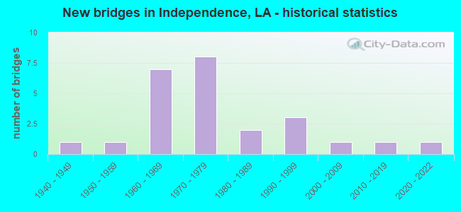
- New bridges - historical statistics
- 11940-1949
- 11950-1959
- 71960-1969
- 81970-1979
- 21980-1989
- 31990-1999
- 12000-2009
- 12010-2019
- 12020-2022


- Bridge Condition - Deck
- 4.5%Very good
- 54.5%Good
- 22.7%Satisfactory
- 13.6%Fair
- 4.5%Poor

- Bridge Condition - Superstructure
- 9.1%Very good
- 50.0%Good
- 18.2%Satisfactory
- 18.2%Fair
- 4.5%Poor

- Bridge Condition - Substructure
- 9.1%Very good
- 50.0%Good
- 13.6%Satisfactory
- 22.7%Fair
- 4.5%Poor

- Bridge Condition - Channel
- 4.5%Very good
- 54.5%Good
- 36.4%Satisfactory
- 4.5%Fair
Find on map >> Show street view
Structure Number: 623204150102641, Location: 2.5 M E OF LA 43 (Lat: 30.643139, Lng: -90.576700), Route carried "on" structure: State highway 40, Year Built: 1960, Status: Open, Structure Length: 1.83m (6.00ft), Average Daily Traffic: 1,600 (year 2016), Truck Traffic: 12%, Average Future Daily Traffic: 1,376 (year 2036), Design Load: HS 20, Features Intersected: L NATALBANY REL
Minimum Vertical Clearance: 30+ m (98+ ft), Kilometerpoint: 4.258, Lanes on structure: 2, Owner: State Highway Agency, Approaching Roadway Width: 10.1m (33.1ft), Material/Design: Concrete, Design/Construction: Slab, Number Of Spans In Main Unit: 3, Length of Maximum Span: 6.1m (20.0ft), Curb-To-Curb Width: 7.3m (24.0ft), Out-to-Out Width: 9.0m (29.5ft)
Condition: Deck: Good, Superstructure: Good, Substructure: Good, Channel: Satisfactory, Operating Rating: 39.0 metric tons, Method Used To Determine Operating Rating: Load Factor (LF), Inventory Rating: 23.6 metric tons, Method Used To Determine Inventory Rating: Load Factor (LF), Structural Evaluation: Equal to present minimum criteria, Deck Geometry: Meets minimum limits, Waterway Adequacy: Better than present minimum criteria, Approach Roadway Alignment: Equal to present desirable criteria, Designated Inspection Frequency: Every 24 months, Inspection Date: March 2020, Deck Structure Type: Concrete Cast-file-Place
Find on map >> Show street view
Structure Number: 623204150103031, Location: 2.9 M E OF LA 43 (Lat: 30.643111, Lng: -90.570100), Route carried "on" structure: State highway 40, Year Built: 1960, Status: Open, Structure Length: 1.83m (6.00ft), Average Daily Traffic: 1,600 (year 2016), Truck Traffic: 12%, Average Future Daily Traffic: 1,376 (year 2036), Design Load: HS 20, Features Intersected: L NATALBANY REL
Minimum Vertical Clearance: 30+ m (98+ ft), Kilometerpoint: 4.886, Lanes on structure: 2, Owner: State Highway Agency, Approaching Roadway Width: 10.7m (35.1ft), Material/Design: Concrete, Design/Construction: Slab, Number Of Spans In Main Unit: 3, Length of Maximum Span: 6.1m (20.0ft), Curb-To-Curb Width: 7.3m (24.0ft), Out-to-Out Width: 9.0m (29.5ft)
Condition: Deck: Good, Superstructure: Good, Substructure: Satisfactory, Channel: Good, Operating Rating: 39.0 metric tons, Method Used To Determine Operating Rating: Load Factor (LF), Inventory Rating: 23.6 metric tons, Method Used To Determine Inventory Rating: Load Factor (LF), Structural Evaluation: Equal to present minimum criteria, Deck Geometry: Meets minimum limits, Waterway Adequacy: Better than present minimum criteria, Approach Roadway Alignment: Equal to present desirable criteria, Designated Inspection Frequency: Every 24 months, Inspection Date: March 2020, Deck Structure Type: Concrete Cast-file-Place
Find on map >> Show street view
Structure Number: 625300000620307, Location: ON VITRANO ROAD 0.20 MILE (Lat: 30.617050, Lng: -90.500050), Route carried "on" structure: County highway , Year Built: 2015, Status: Open, Structure Length: 0.64m (2.10ft), Average Daily Traffic: 145 (year 2020), Average Future Daily Traffic: 160 (year 2040), Design Load: HS 20, Features Intersected: PONCHATOULA CREEK, Facility Carried by Structure: Vitrano Rd
Minimum Vertical Clearance: 30+ m (98+ ft), Kilometerpoint: 0.000, Lanes on structure: 2, Owner: County Highway Agency, Approaching Roadway Width: 5.5m (18.0ft), Skew: 30 degrees, Material/Design: Steel, Design/Construction: Culvert, Number Of Spans In Main Unit: 3, Length of Maximum Span: 1.8m (5.9ft)
Condition: Channel: Good, Culverts: Good, Operating Rating: 97.2 metric tons, Method Used To Determine Operating Rating: Load and Resistance Factor Rating (LRFR) rating reported by rating factor(RF) method using HL-93 loadings, Inventory Rating: 74.5 metric tons, Method Used To Determine Inventory Rating: Load and Resistance Factor Rating (LRFR) rating reported by rating factor(RF) method using HL-93 loadings, Structural Evaluation: Better than present minimum criteria, Waterway Adequacy: Better than present minimum criteria, Approach Roadway Alignment: Equal to present desirable criteria, Designated Inspection Frequency: Every 24 months, Inspection Date: August 2021
Find on map >> Show street view
Structure Number: 625300000625304, Location: 0.5 Mi. West of US 51 (Lat: 30.616039, Lng: -90.504861), Route carried "on" structure: County highway , Year Built: 2020, Status: Open, Structure Length: 2.44m (8.01ft), Average Daily Traffic: 145 (year 2020), Average Future Daily Traffic: 160 (year 2040), Design Load: Greater than HL93, Features Intersected: Ponchatoula Creek, Facility Carried by Structure: Vintrano Road
Minimum Vertical Clearance: 30+ m (98+ ft), Kilometerpoint: 0.340, Lanes on structure: 2, Owner: County Highway Agency, Approaching Roadway Width: 8.3m (27.2ft), Skew: 3 degrees, Material/Design: Concrete, Design/Construction: Slab, Number Of Spans In Main Unit: 4, Length of Maximum Span: 6.1m (20.0ft), Curb-To-Curb Width: 8.3m (27.2ft), Out-to-Out Width: 9.1m (29.9ft)
Condition: Deck: Very good, Superstructure: Very good, Substructure: Very good, Channel: Very good, Operating Rating: 56.7 metric tons, Method Used To Determine Operating Rating: Load and Resistance Factor Rating (LRFR) rating reported by rating factor(RF) method using HL-93 loadings, Inventory Rating: 43.7 metric tons, Method Used To Determine Inventory Rating: Load and Resistance Factor Rating (LRFR) rating reported by rating factor(RF) method using HL-93 loadings, Structural Evaluation: Equal to present desirable criteria, Deck Geometry: Somewhat better than minimum adequacy, Waterway Adequacy: Better than present minimum criteria, Approach Roadway Alignment: Better than present minimum criteria, Designated Inspection Frequency: Every 24 months, Inspection Date: March 2021, Deck Structure Type: Concrete Cast-file-Place
Find on map >> Show street view
Structure Number: 625304150201671, Location: 0.5 M W OF I-55 (Lat: 30.642939, Lng: -90.539300), Route carried "on" structure: State highway 40, Year Built: 1971, Status: Posted for load, Structure Length: 5.24m (17.19ft), Average Daily Traffic: 5,600 (year 2016), Truck Traffic: 12%, Average Future Daily Traffic: 5,180 (year 2036), Design Load: HS 20, Features Intersected: NATALBANY RIVER
Minimum Vertical Clearance: 30+ m (98+ ft), Kilometerpoint: 2.673, Lanes on structure: 2, Owner: State Highway Agency, Approaching Roadway Width: 7.9m (25.9ft), Material/Design: Concrete, Design/Construction: Slab, Number Of Spans In Main Unit: 8, Length of Maximum Span: 5.8m (19.0ft), Curb-To-Curb Width: 8.5m (27.9ft), Out-to-Out Width: 9.4m (30.8ft)
Condition: Deck: Fair, Superstructure: Fair, Substructure: Fair, Channel: Satisfactory, Operating Rating: 25.3 metric tons, Method Used To Determine Operating Rating: Load and Resistance Factor Rating (LRFR) rating reported by rating factor(RF) method using HL-93 loadings, Inventory Rating: 19.8 metric tons, Method Used To Determine Inventory Rating: Load and Resistance Factor Rating (LRFR) rating reported by rating factor(RF) method using HL-93 loadings, Structural Evaluation: Somewhat better than minimum adequacy, Deck Geometry: High priority of replacement, Waterway Adequacy: Equal to present minimum criteria, Approach Roadway Alignment: Equal to present desirable criteria, Bridge Posting: Required (Relationship of Operating Rating to Maximum Legal Load: 20.0 - 29.9% below), Length Of Structure Improvement: 6.16m (20.21ft), Designated Inspection Frequency: Every 24 months, Inspection Date: April 2021, Bridge Improvement Cost: $525,000, Total Project Cost: $787,000 ( Estimate for 2016), Deck Structure Type: Concrete Precast Panels, Wearing Surface/Protective System: Wearing Surface: Bituminous
Find on map >> Show street view
Structure Number: 625304150202481, Location: LA0040 (Lat: 30.641211, Lng: -90.526000), Route carried "on" structure: State highway 40, Year Built: 1970, Status: Open, Structure Length: 7.68m (25.20ft), Average Daily Traffic: 5,600 (year 2016), Truck Traffic: 9%, Average Future Daily Traffic: 5,180 (year 2036), Design Load: HS 20, Features Intersected: LA 40 OVER I-55
Minimum Vertical Clearance: 30+ m (98+ ft), Kilometerpoint: 3.965, Lanes on structure: 2, Lanes under structure: 4, Owner: State Highway Agency, Approaching Roadway Width: 14.0m (45.9ft), Skew: 6 degrees, Material/Design: Prestressed concrete, Design/Construction: Stringer/Multi-beam, Number Of Spans In Main Unit: 4, Length of Maximum Span: 24.4m (80.1ft), Curb-To-Curb Width: 8.5m (27.9ft), Out-to-Out Width: 10.4m (34.1ft)
Condition: Deck: Good, Superstructure: Good, Substructure: Satisfactory, Operating Rating: 80.7 metric tons, Method Used To Determine Operating Rating: Load Factor (LF), Inventory Rating: 39.9 metric tons, Method Used To Determine Inventory Rating: Load Factor (LF), Structural Evaluation: Equal to present minimum criteria, Deck Geometry: Meets minimum limits, Underclear: High priority of replacement, Approach Roadway Alignment: Equal to present desirable criteria, Length Of Structure Improvement: 8.60m (28.22ft), Designated Inspection Frequency: Every 24 months, Inspection Date: January 2021, Bridge Improvement Cost: $733,000, Total Project Cost: $1,099,000 ( Estimate for 2016), Deck Structure Type: Concrete Cast-file-Place
Find on map >> Show street view
Structure Number: 625304150202781, Location: 2.78 MI EAST OF PARISH LN (Lat: 30.640231, Lng: -90.521200), Route carried "on" structure: State highway 40, Year Built: 1964, Status: Open, Structure Length: 0.79m (2.59ft), Average Daily Traffic: 5,600 (year 2016), Truck Traffic: 9%, Average Future Daily Traffic: 5,180 (year 2036), Design Load: HS 20, Features Intersected: CREEK
Minimum Vertical Clearance: 30+ m (98+ ft), Kilometerpoint: 4.440, Lanes on structure: 2, Owner: State Highway Agency, Approaching Roadway Width: 13.1m (43.0ft), Material/Design: Concrete, Design/Construction: Culvert, Number Of Spans In Main Unit: 3, Length of Maximum Span: 2.4m (7.9ft)
Condition: Channel: Good, Culverts: Good, Operating Rating: 42.1 metric tons, Method Used To Determine Operating Rating: Load and Resistance Factor Rating (LRFR) rating reported by rating factor(RF) method using HL-93 loadings, Inventory Rating: 32.4 metric tons, Method Used To Determine Inventory Rating: Load and Resistance Factor Rating (LRFR) rating reported by rating factor(RF) method using HL-93 loadings, Structural Evaluation: Better than present minimum criteria, Waterway Adequacy: Better than present minimum criteria, Approach Roadway Alignment: Equal to present desirable criteria, Designated Inspection Frequency: Every 24 months, Inspection Date: April 2021, Deck Structure Type: Concrete Cast-file-Place
Find on map >> Show street view
Structure Number: 625304150203251, Location: 0.73 MI. W OF US 51 (Lat: 30.637639, Lng: -90.514400), Route carried "on" structure: State highway 40, Year Built: 1976, Status: Open, Structure Length: 0.88m (2.89ft), Average Daily Traffic: 5,600 (year 2016), Truck Traffic: 9%, Average Future Daily Traffic: 5,180 (year 2036), Design Load: HS 20, Features Intersected: PONCHATOULA CREEK
Minimum Vertical Clearance: 30+ m (98+ ft), Kilometerpoint: 5.152, Lanes on structure: 2, Owner: State Highway Agency, Approaching Roadway Width: 12.2m (40.0ft), Skew: 36 degrees, Material/Design: Concrete, Design/Construction: Culvert, Number Of Spans In Main Unit: 3, Length of Maximum Span: 2.4m (7.9ft), Curb-To-Curb Width: 7.3m (24.0ft), Out-to-Out Width: 15.9m (52.2ft)
Condition: Channel: Satisfactory, Culverts: Good, Operating Rating: 42.1 metric tons, Method Used To Determine Operating Rating: Load and Resistance Factor Rating (LRFR) rating reported by rating factor(RF) method using HL-93 loadings, Inventory Rating: 32.4 metric tons, Method Used To Determine Inventory Rating: Load and Resistance Factor Rating (LRFR) rating reported by rating factor(RF) method using HL-93 loadings, Structural Evaluation: Better than present minimum criteria, Deck Geometry: High priority of replacement, Waterway Adequacy: Equal to present desirable criteria, Approach Roadway Alignment: Equal to present desirable criteria, Length Of Structure Improvement: 1.49m (4.89ft), Designated Inspection Frequency: Every 24 months, Inspection Date: April 2021, Bridge Improvement Cost: $127,000, Total Project Cost: $190,000 ( Estimate for 2016), Deck Structure Type: Concrete Cast-file-Place
Find on map >> Show street view
Structure Number: 625304150301051, Location: LA 40 LOG MILE 01.05 (Lat: 30.636850, Lng: -90.484900), Route carried "on" structure: State highway 40, Year Built: 1982, Status: Open, Structure Length: 1.19m (3.90ft), Average Daily Traffic: 4,100 (year 2016), Truck Traffic: 12%, Average Future Daily Traffic: 2,520 (year 2036), Design Load: HS 20, Features Intersected: DRAIN
Minimum Vertical Clearance: 30+ m (98+ ft), Kilometerpoint: 1.679, Lanes on structure: 2, Owner: State Highway Agency, Approaching Roadway Width: 8.5m (27.9ft), Material/Design: Concrete, Design/Construction: Slab, Number Of Spans In Main Unit: 2, Length of Maximum Span: 5.8m (19.0ft), Curb-To-Curb Width: 9.8m (32.2ft), Out-to-Out Width: 10.7m (35.1ft)
Condition: Deck: Good, Superstructure: Good, Substructure: Good, Channel: Good, Operating Rating: 62.6 metric tons, Method Used To Determine Operating Rating: Load Factor (LF), Inventory Rating: 37.2 metric tons, Method Used To Determine Inventory Rating: Load Factor (LF), Structural Evaluation: Better than present minimum criteria, Deck Geometry: Meets minimum limits, Waterway Adequacy: Better than present minimum criteria, Approach Roadway Alignment: Equal to present desirable criteria, Designated Inspection Frequency: Every 24 months, Inspection Date: April 2021, Deck Structure Type: Concrete Precast Panels, Wearing Surface/Protective System: Wearing Surface: Bituminous
Find on map >> Show street view
Structure Number: 625304150301331, Location: 1.3 Miles East of US 51 (Lat: 30.636931, Lng: -90.480400), Route carried "on" structure: State highway 40, Year Built: 1965, Status: Posted for load, Structure Length: 18.59m (60.99ft), Average Daily Traffic: 4,100 (year 2016), Truck Traffic: 12%, Average Future Daily Traffic: 2,520 (year 2036), Design Load: H 15, Features Intersected: TANGIPAHOA RIVER
Minimum Vertical Clearance: 30+ m (98+ ft), Kilometerpoint: 2.108, Lanes on structure: 2, Owner: State Highway Agency, Approaching Roadway Width: 11.9m (39.0ft), Material/Design: Steel, Design/Construction: Girder and Floorbeam System, Number Of Spans In Main Unit: 1, Number Of Approach Spans: 4, Length of Maximum Span: 106.7m (350.1ft), Curb-To-Curb Width: 7.4m (24.3ft), Out-to-Out Width: 9.0m (29.5ft)
Condition: Deck: Good, Superstructure: Good, Substructure: Good, Channel: Good, Operating Rating: 32.7 metric tons, Method Used To Determine Operating Rating: Load Factor (LF), Inventory Rating: 19.0 metric tons, Method Used To Determine Inventory Rating: Load Factor (LF), Structural Evaluation: Somewhat better than minimum adequacy, Deck Geometry: High priority of replacement, Waterway Adequacy: Better than present minimum criteria, Approach Roadway Alignment: Better than present minimum criteria, Bridge Posting: Required (Relationship of Operating Rating to Maximum Legal Load: 10.0 - 19.9% below), Length Of Structure Improvement: 19.32m (63.39ft), Designated Inspection Frequency: Every 24 months, Critical Feature Inspection Frequency: Every 24 months, Underwater Inspection Frequency: Every 60 months, Inspection Date: December 2020, Critical Feature Inspection Date: December 2020, Underwater Inspection Date: August 2019, Bridge Improvement Cost: $1,648,000, Total Project Cost: $2,472,000 ( Estimate for 2016), Deck Structure Type: Concrete Cast-file-Place
Find on map >> Show street view
Structure Number: 625304150302781, Location: 0.7 M SE OF LA 1054 (Lat: 30.637439, Lng: -90.462300), Route carried "on" structure: State highway 40, Year Built: 1981, Status: Open, Structure Length: 1.77m (5.81ft), Average Daily Traffic: 4,100 (year 2016), Truck Traffic: 12%, Average Future Daily Traffic: 2,520 (year 2036), Design Load: HS 20, Features Intersected: DAVIS BRANCH
Minimum Vertical Clearance: 30+ m (98+ ft), Kilometerpoint: 4.451, Lanes on structure: 2, Owner: State Highway Agency, Approaching Roadway Width: 9.1m (29.9ft), Material/Design: Concrete, Design/Construction: Slab, Number Of Spans In Main Unit: 3, Length of Maximum Span: 5.8m (19.0ft), Curb-To-Curb Width: 9.8m (32.2ft), Out-to-Out Width: 10.7m (35.1ft)
Condition: Deck: Good, Superstructure: Good, Substructure: Good, Channel: Good, Operating Rating: 62.6 metric tons, Method Used To Determine Operating Rating: Load Factor (LF), Inventory Rating: 37.2 metric tons, Method Used To Determine Inventory Rating: Load Factor (LF), Structural Evaluation: Better than present minimum criteria, Deck Geometry: Meets minimum limits, Waterway Adequacy: Better than present minimum criteria, Approach Roadway Alignment: Equal to present desirable criteria, Designated Inspection Frequency: Every 24 months, Inspection Date: April 2021, Deck Structure Type: Concrete Precast Panels, Wearing Surface/Protective System: Wearing Surface: Bituminous
Find on map >> Show street view
Structure Number: 625304150303541, Location: 2.8 M W OF LA 1062 (Lat: 30.635861, Lng: -90.450200), Route carried "on" structure: State highway 40, Year Built: 1970, Status: Open, Structure Length: 3.51m (11.52ft), Average Daily Traffic: 4,100 (year 2016), Truck Traffic: 12%, Average Future Daily Traffic: 2,520 (year 2036), Design Load: HS 20, Features Intersected: SWEETWATER CREEK
Minimum Vertical Clearance: 30+ m (98+ ft), Kilometerpoint: 5.686, Lanes on structure: 2, Owner: State Highway Agency, Approaching Roadway Width: 7.9m (25.9ft), Material/Design: Concrete, Design/Construction: Slab, Number Of Spans In Main Unit: 6, Length of Maximum Span: 5.8m (19.0ft), Curb-To-Curb Width: 8.5m (27.9ft), Out-to-Out Width: 9.4m (30.8ft)
Condition: Deck: Fair, Superstructure: Fair, Substructure: Fair, Channel: Satisfactory, Operating Rating: 62.6 metric tons, Method Used To Determine Operating Rating: Load Factor (LF), Inventory Rating: 37.2 metric tons, Method Used To Determine Inventory Rating: Load Factor (LF), Structural Evaluation: Somewhat better than minimum adequacy, Deck Geometry: Meets minimum limits, Waterway Adequacy: Equal to present minimum criteria, Approach Roadway Alignment: Equal to present desirable criteria, Designated Inspection Frequency: Every 24 months, Underwater Inspection Frequency: Every 60 months, Inspection Date: April 2021, Underwater Inspection Date: August 2019, Deck Structure Type: Concrete Precast Panels, Wearing Surface/Protective System: Wearing Surface: Bituminous
Find on map >> Show street view
Structure Number: 625304150303851, Location: 2.6 M W OF LA 1062 (Lat: 30.635889, Lng: -90.445400), Route carried "on" structure: State highway 40, Year Built: 1970, Status: Open, Structure Length: 2.35m (7.71ft), Average Daily Traffic: 4,100 (year 2016), Truck Traffic: 12%, Average Future Daily Traffic: 2,520 (year 2036), Design Load: HS 20, Features Intersected: SCOTT CREEK
Minimum Vertical Clearance: 30+ m (98+ ft), Kilometerpoint: 6.141, Lanes on structure: 2, Owner: State Highway Agency, Approaching Roadway Width: 8.5m (27.9ft), Material/Design: Concrete, Design/Construction: Slab, Number Of Spans In Main Unit: 4, Length of Maximum Span: 5.8m (19.0ft), Curb-To-Curb Width: 8.5m (27.9ft), Out-to-Out Width: 9.4m (30.8ft)
Condition: Deck: Poor, Superstructure: Poor, Substructure: Fair, Channel: Satisfactory, Operating Rating: 62.6 metric tons, Method Used To Determine Operating Rating: Load Factor (LF), Inventory Rating: 37.2 metric tons, Method Used To Determine Inventory Rating: Load Factor (LF), Structural Evaluation: Meets minimum limits, Deck Geometry: Meets minimum limits, Waterway Adequacy: Better than present minimum criteria, Approach Roadway Alignment: Equal to present desirable criteria, Designated Inspection Frequency: Every 24 months, Other Special Inspection Frequency: Every 12 months, Inspection Date: April 2021, Other Special Inspection Date: April 2020, Deck Structure Type: Concrete Precast Panels, Wearing Surface/Protective System: Wearing Surface: Bituminous
Find on map >> Show street view
Structure Number: 625304529024061, Location: 1.9 M N OF LA 442 (Lat: 30.606719, Lng: -90.512600), Route carried "on" structure: County highway , Year Built: 1970, Status: Open, Structure Length: 7.07m (23.20ft), Average Daily Traffic: 3,610 (year 2015), Average Future Daily Traffic: 2,527 (year 2036), Design Load: HS 20, Features Intersected: I-55, Facility Carried by Structure: W BLACKCAT Rd
Minimum Vertical Clearance: 30+ m (98+ ft), Kilometerpoint: 38.748, Lanes on structure: 2, Lanes under structure: 4, Base Highway Network: Yes (Inventory Route: 452-90-1, Subroute: 10), Owner: State Highway Agency, Approaching Roadway Width: 9.1m (29.9ft), Material/Design: Prestressed concrete, Design/Construction: Stringer/Multi-beam, Number Of Spans In Main Unit: 4, Length of Maximum Span: 22.9m (75.1ft), Curb-To-Curb Width: 7.3m (24.0ft), Out-to-Out Width: 9.1m (29.9ft)
Condition: Deck: Good, Superstructure: Very good, Substructure: Very good, Operating Rating: 77.1 metric tons, Method Used To Determine Operating Rating: Load Factor (LF), Inventory Rating: 27.2 metric tons, Method Used To Determine Inventory Rating: Load Factor (LF), Structural Evaluation: Equal to present minimum criteria, Deck Geometry: High priority of replacement, Underclear: Meets minimum limits, Approach Roadway Alignment: Equal to present desirable criteria, Length Of Structure Improvement: 7.99m (26.21ft), Designated Inspection Frequency: Every 24 months, Inspection Date: January 2021, Bridge Improvement Cost: $681,000, Total Project Cost: $1,021,000 ( Estimate for 2016), Deck Structure Type: Concrete Cast-file-Place
Find on map >> Show street view
Structure Number: 625304529028881, Location: I0055 (Lat: 30.673931, Lng: -90.532500), Route carried "on" structure: Interstate 55, Year Built: 1968, Status: Open, Structure Length: 4.57m (14.99ft), Average Daily Traffic: 12,650 (year 2016), Truck Traffic: 26%, Average Future Daily Traffic: 11,004 (year 2036), Design Load: HS 20, Features Intersected: LITTLE NAT RIVER
Minimum Vertical Clearance: 30+ m (98+ ft), Kilometerpoint: 46.515, Lanes on structure: 2, Base Highway Network: Yes (Inventory Route: 452-90-1, Subroute: 10), Owner: State Highway Agency, Approaching Roadway Width: 13.1m (43.0ft), Skew: 17 degrees, Material/Design: Concrete, Design/Construction: Slab, Number Of Spans In Main Unit: 6, Length of Maximum Span: 7.6m (24.9ft), Curb-To-Curb Width: 8.5m (27.9ft), Out-to-Out Width: 10.2m (33.5ft)
Condition: Deck: Satisfactory, Superstructure: Satisfactory, Substructure: Good, Channel: Good, Operating Rating: 40.2 metric tons, Method Used To Determine Operating Rating: Load and Resistance Factor Rating (LRFR) rating reported by rating factor(RF) method using HL-93 loadings, Inventory Rating: 31.1 metric tons, Method Used To Determine Inventory Rating: Load and Resistance Factor Rating (LRFR) rating reported by rating factor(RF) method using HL-93 loadings, Structural Evaluation: Equal to present minimum criteria, Deck Geometry: High priority of replacement, Waterway Adequacy: Better than present minimum criteria, Approach Roadway Alignment: Equal to present desirable criteria, Length Of Structure Improvement: 5.49m (18.01ft), Designated Inspection Frequency: Every 24 months, Inspection Date: January 2021, Bridge Improvement Cost: $468,000, Total Project Cost: $702,000 ( Estimate for 2016), Deck Structure Type: Concrete Cast-file-Place
Find on map >> Show street view
Structure Number: 625304529028882, Location: I0055 (Lat: 30.674289, Lng: -90.532800), Route carried "on" structure: Interstate 55, Year Built: 1968, Status: Open, Structure Length: 4.57m (14.99ft), Average Daily Traffic: 12,650 (year 2016), Truck Traffic: 26%, Average Future Daily Traffic: 11,004 (year 2036), Design Load: HS 20, Features Intersected: LITTLE NAT RIVER
Minimum Vertical Clearance: 30+ m (98+ ft), Kilometerpoint: 36.455, Lanes on structure: 2, Base Highway Network: Yes (Inventory Route: 452-90-2, Subroute: 10), Owner: State Highway Agency, Approaching Roadway Width: 13.7m (44.9ft), Skew: 17 degrees, Material/Design: Concrete, Design/Construction: Slab, Number Of Spans In Main Unit: 6, Length of Maximum Span: 7.6m (24.9ft), Curb-To-Curb Width: 8.5m (27.9ft), Out-to-Out Width: 10.3m (33.8ft)
Condition: Deck: Good, Superstructure: Good, Substructure: Good, Channel: Good, Operating Rating: 66.2 metric tons, Method Used To Determine Operating Rating: Load Factor (LF), Inventory Rating: 39.9 metric tons, Method Used To Determine Inventory Rating: Load Factor (LF), Structural Evaluation: Better than present minimum criteria, Deck Geometry: High priority of replacement, Waterway Adequacy: Equal to present minimum criteria, Approach Roadway Alignment: Equal to present desirable criteria, Length Of Structure Improvement: 5.49m (18.01ft), Designated Inspection Frequency: Every 24 months, Inspection Date: January 2021, Bridge Improvement Cost: $468,000, Total Project Cost: $702,000 ( Estimate for 2016), Deck Structure Type: Concrete Cast-file-Place
Find on map >> Show street view
Structure Number: 625308533403601, Location: LA1063 (Lat: 30.603539, Lng: -90.533900), Route carried "on" structure: State highway 1063, Year Built: 1962, Status: Open, Structure Length: 5.55m (18.21ft), Average Daily Traffic: 1,190 (year 2016), Truck Traffic: 13%, Average Future Daily Traffic: 833 (year 2036), Design Load: HS 20, Features Intersected: NATALBANY RIVER
Minimum Vertical Clearance: 30+ m (98+ ft), Kilometerpoint: 5.729, Lanes on structure: 2, Owner: State Highway Agency, Approaching Roadway Width: 7.9m (25.9ft), Material/Design: Steel, Design/Construction: Stringer/Multi-beam, Number Of Spans In Main Unit: 4, Length of Maximum Span: 15.2m (49.9ft), Curb-To-Curb Width: 7.3m (24.0ft), Out-to-Out Width: 8.9m (29.2ft)
Condition: Deck: Good, Superstructure: Good, Substructure: Good, Channel: Good, Operating Rating: 43.5 metric tons, Method Used To Determine Operating Rating: Load Factor (LF), Inventory Rating: 26.3 metric tons, Method Used To Determine Inventory Rating: Load Factor (LF), Structural Evaluation: Equal to present minimum criteria, Deck Geometry: Meets minimum limits, Waterway Adequacy: Better than present minimum criteria, Approach Roadway Alignment: Better than present minimum criteria, Designated Inspection Frequency: Every 24 months, Inspection Date: Febuary 2021, Deck Structure Type: Concrete Cast-file-Place
Find on map >> Show street view
Structure Number: 625308533405191, Location: LA1063 (Lat: 30.622850, Lng: -90.518900), Route carried "on" structure: State highway 1063, Year Built: 1970, Status: Open, Structure Length: 7.68m (25.20ft), Average Daily Traffic: 1,190 (year 2016), Truck Traffic: 9%, Average Future Daily Traffic: 833 (year 2036), Design Load: HS 20, Features Intersected: LA 1063 OVER I-55
Minimum Vertical Clearance: 30+ m (98+ ft), Kilometerpoint: 8.428, Lanes on structure: 2, Lanes under structure: 4, Owner: State Highway Agency, Approaching Roadway Width: 10.7m (35.1ft), Skew: 6 degrees, Material/Design: Prestressed concrete, Design/Construction: Stringer/Multi-beam, Number Of Spans In Main Unit: 4, Length of Maximum Span: 24.4m (80.1ft), Curb-To-Curb Width: 7.3m (24.0ft), Out-to-Out Width: 9.1m (29.9ft)
Condition: Deck: Good, Superstructure: Good, Substructure: Good, Operating Rating: 74.4 metric tons, Method Used To Determine Operating Rating: Load Factor (LF), Inventory Rating: 33.6 metric tons, Method Used To Determine Inventory Rating: Load Factor (LF), Structural Evaluation: Better than present minimum criteria, Deck Geometry: Meets minimum limits, Underclear: High priority of replacement, Approach Roadway Alignment: Equal to present desirable criteria, Length Of Structure Improvement: 8.60m (28.22ft), Designated Inspection Frequency: Every 24 months, Inspection Date: January 2021, Bridge Improvement Cost: $733,000, Total Project Cost: $1,099,000 ( Estimate for 2016), Deck Structure Type: Concrete Cast-file-Place
Find on map >> Show street view
Structure Number: 625308533405661, Location: 0.9 M W OF US 51 (Lat: 30.626281, Lng: -90.514400), Route carried "on" structure: State highway 1063, Year Built: 1949, Status: Posted for load, Structure Length: 1.19m (3.90ft), Average Daily Traffic: 1,190 (year 2016), Truck Traffic: 9%, Average Future Daily Traffic: 833 (year 2036), Design Load: H 10, Features Intersected: CREEK
Minimum Vertical Clearance: 30+ m (98+ ft), Kilometerpoint: 8.998, Lanes on structure: 2, Owner: State Highway Agency, Approaching Roadway Width: 9.8m (32.2ft), Material/Design: Wood or Timber, Design/Construction: Stringer/Multi-beam, Number Of Spans In Main Unit: 2, Length of Maximum Span: 5.8m (19.0ft), Curb-To-Curb Width: 7.6m (24.9ft), Out-to-Out Width: 8.4m (27.6ft)
Condition: Deck: Satisfactory, Superstructure: Fair, Substructure: Fair, Channel: Satisfactory, Operating Rating: 22.7 metric tons, Method Used To Determine Operating Rating: Allowable Stress (AS), Inventory Rating: 15.4 metric tons, Method Used To Determine Inventory Rating: Allowable Stress (AS), Structural Evaluation: Meets minimum limits, Deck Geometry: Meets minimum limits, Waterway Adequacy: Equal to present minimum criteria, Approach Roadway Alignment: Equal to present desirable criteria, Bridge Posting: Required (Relationship of Operating Rating to Maximum Legal Load: 0.1 - 9.9% below), Designated Inspection Frequency: Every 24 months, Inspection Date: Febuary 2021, Deck Structure Type: Wood or Timber, Wearing Surface/Protective System: Wearing Surface: Bituminous
Find on map >> Show street view
Structure Number: 625308533405821, Location: 0.8 M W OF US 51 (Lat: 30.627619, Lng: -90.512200), Route carried "on" structure: State highway 1063, Year Built: 1956, Status: Posted for load, Structure Length: 1.77m (5.81ft), Average Daily Traffic: 1,190 (year 2016), Truck Traffic: 9%, Average Future Daily Traffic: 833 (year 2036), Design Load: H 15, Features Intersected: CANAL
Minimum Vertical Clearance: 30+ m (98+ ft), Kilometerpoint: 9.259, Lanes on structure: 2, Owner: State Highway Agency, Approaching Roadway Width: 9.4m (30.8ft), Material/Design: Wood or Timber, Design/Construction: Stringer/Multi-beam, Number Of Spans In Main Unit: 3, Length of Maximum Span: 5.8m (19.0ft), Curb-To-Curb Width: 7.6m (24.9ft), Out-to-Out Width: 8.4m (27.6ft)
Condition: Deck: Satisfactory, Superstructure: Satisfactory, Substructure: Fair, Channel: Good, Operating Rating: 23.6 metric tons, Method Used To Determine Operating Rating: Allowable Stress (AS), Inventory Rating: 15.4 metric tons, Method Used To Determine Inventory Rating: Allowable Stress (AS), Structural Evaluation: Meets minimum limits, Deck Geometry: Meets minimum limits, Waterway Adequacy: Better than present minimum criteria, Approach Roadway Alignment: Equal to present desirable criteria, Bridge Posting: Required (Relationship of Operating Rating to Maximum Legal Load: 0.1 - 9.9% below), Designated Inspection Frequency: Every 24 months, Inspection Date: Febuary 2021, Deck Structure Type: Wood or Timber, Wearing Surface/Protective System: Wearing Surface: Bituminous
Find on map >> Show street view
Structure Number: 625330364902981, Location: BLACK CAT ROAD (Lat: 30.606719, Lng: -90.497339), Route carried "on" structure: County highway , Year Built: 1992, Status: Open, Structure Length: 2.32m (7.61ft), Average Daily Traffic: 873 (year 2020), Average Future Daily Traffic: 961 (year 2040), Design Load: HS 20, Features Intersected: PONCHATOULA CREEK, Facility Carried by Structure: W. Black cat Rd
Minimum Vertical Clearance: 30+ m (98+ ft), Kilometerpoint: 0.000, Lanes on structure: 2, Owner: County Highway Agency, Approaching Roadway Width: 7.3m (24.0ft), Material/Design: Concrete, Design/Construction: Slab, Number Of Spans In Main Unit: 4, Length of Maximum Span: 5.8m (19.0ft), Curb-To-Curb Width: 9.0m (29.5ft), Out-to-Out Width: 9.3m (30.5ft)
Condition: Deck: Good, Superstructure: Good, Substructure: Satisfactory, Channel: Satisfactory, Operating Rating: 52.2 metric tons, Method Used To Determine Operating Rating: Load and Resistance Factor Rating (LRFR) rating reported by rating factor(RF) method using HL-93 loadings, Inventory Rating: 40.2 metric tons, Method Used To Determine Inventory Rating: Load and Resistance Factor Rating (LRFR) rating reported by rating factor(RF) method using HL-93 loadings, Structural Evaluation: Equal to present minimum criteria, Deck Geometry: Somewhat better than minimum adequacy, Waterway Adequacy: Better than present minimum criteria, Approach Roadway Alignment: Better than present minimum criteria, Designated Inspection Frequency: Every 24 months, Inspection Date: May 2021, Deck Structure Type: Concrete Cast-file-Place
Find on map >> Show street view
Structure Number: 625330371903021, Location: 1.5 MI NW OF JCT 51 (Lat: 30.619939, Lng: -90.501019), Route carried "on" structure: County highway , Year Built: 1975, Status: Posted for load, Structure Length: 1.19m (3.90ft), Average Daily Traffic: 310 (year 2020), Average Future Daily Traffic: 341 (year 2040), Design Load: H 10, Features Intersected: CREEK, Facility Carried by Structure: Berry Bowl Rd
Minimum Vertical Clearance: 30+ m (98+ ft), Kilometerpoint: 0.000, Lanes on structure: 2, Owner: County Highway Agency, Approaching Roadway Width: 6.1m (20.0ft), Material/Design: Wood or Timber, Design/Construction: Stringer/Multi-beam, Number Of Spans In Main Unit: 2, Length of Maximum Span: 5.8m (19.0ft), Curb-To-Curb Width: 6.4m (21.0ft), Out-to-Out Width: 7.1m (23.3ft)
Condition: Deck: Fair, Superstructure: Satisfactory, Substructure: Poor, Channel: Fair, Operating Rating: 20.0 metric tons, Method Used To Determine Operating Rating: Allowable Stress (AS), Inventory Rating: 14.5 metric tons, Method Used To Determine Inventory Rating: Allowable Stress (AS), Structural Evaluation: Meets minimum limits, Deck Geometry: Meets minimum limits, Waterway Adequacy: Better than present minimum criteria, Approach Roadway Alignment: Better than present minimum criteria, Bridge Posting: Required (Relationship of Operating Rating to Maximum Legal Load: 20.0 - 29.9% below), Length Of Structure Improvement: 1.83m (6.00ft), Designated Inspection Frequency: Every 24 months, Other Special Inspection Frequency: Every 12 months, Inspection Date: April 2021, Bridge Improvement Cost: $109,000, Total Project Cost: $163,000 ( Estimate for 2016), Deck Structure Type: Wood or Timber, Wearing Surface/Protective System: Wearing Surface: Bituminous
Find on map >> Show street view
Structure Number: 625330371903061, Location: .9MI.S.1063ONALESS.RD.NEW (Lat: 30.618711, Lng: -90.508550), Route carried "on" structure: County highway , Year Built: 1998, Status: Open, Structure Length: 2.90m (9.51ft), Average Daily Traffic: 545 (year 2020), Average Future Daily Traffic: 600 (year 2040), Design Load: HS 20, Features Intersected: PONCHATOULA CREEK, Facility Carried by Structure: Danna Rd
Minimum Vertical Clearance: 30+ m (98+ ft), Kilometerpoint: 0.000, Lanes on structure: 2, Base Highway Network: Yes, Owner: County Highway Agency, Approaching Roadway Width: 7.9m (25.9ft), Skew: 4 degrees, Material/Design: Concrete, Design/Construction: Slab, Number Of Spans In Main Unit: 5, Length of Maximum Span: 5.8m (19.0ft), Curb-To-Curb Width: 7.3m (24.0ft), Out-to-Out Width: 8.2m (26.9ft)
Condition: Deck: Satisfactory, Superstructure: Satisfactory, Substructure: Good, Channel: Good, Operating Rating: 51.2 metric tons, Method Used To Determine Operating Rating: Load and Resistance Factor Rating (LRFR) rating reported by rating factor(RF) method using HL-93 loadings, Inventory Rating: 39.5 metric tons, Method Used To Determine Inventory Rating: Load and Resistance Factor Rating (LRFR) rating reported by rating factor(RF) method using HL-93 loadings, Structural Evaluation: Equal to present minimum criteria, Deck Geometry: Meets minimum limits, Waterway Adequacy: Equal to present desirable criteria, Approach Roadway Alignment: Equal to present desirable criteria, Designated Inspection Frequency: Every 24 months, Inspection Date: April 2021, Deck Structure Type: Concrete Cast-file-Place
Find on map >> Show street view
Structure Number: 625330372903201, Location: 0.7 MI WEST OF LA 1063 (Lat: 30.621050, Lng: -90.533869), Route carried "on" structure: County highway , Year Built: 1992, Status: Open, Structure Length: 5.79m (19.00ft), Average Daily Traffic: 200 (year 2016), Average Future Daily Traffic: 140 (year 2036), Design Load: HS 20, Features Intersected: NATALBANY RIVER, Facility Carried by Structure: E. Evans Rd
Minimum Vertical Clearance: 30+ m (98+ ft), Kilometerpoint: 0.000, Lanes on structure: 2, Owner: County Highway Agency, Approaching Roadway Width: 6.1m (20.0ft), Material/Design: Concrete, Design/Construction: Slab, Number Of Spans In Main Unit: 10, Length of Maximum Span: 5.8m (19.0ft), Curb-To-Curb Width: 7.3m (24.0ft), Out-to-Out Width: 8.1m (26.6ft)
Condition: Deck: Good, Superstructure: Good, Substructure: Good, Channel: Good, Operating Rating: 51.2 metric tons, Method Used To Determine Operating Rating: Load and Resistance Factor Rating (LRFR) rating reported by rating factor(RF) method using HL-93 loadings, Inventory Rating: 39.5 metric tons, Method Used To Determine Inventory Rating: Load and Resistance Factor Rating (LRFR) rating reported by rating factor(RF) method using HL-93 loadings, Structural Evaluation: Better than present minimum criteria, Deck Geometry: Somewhat better than minimum adequacy, Waterway Adequacy: Better than present minimum criteria, Approach Roadway Alignment: Equal to present desirable criteria, Designated Inspection Frequency: Every 24 months, Inspection Date: March 2021, Deck Structure Type: Concrete Precast Panels
Find on map >> Show street view
Structure Number: 625330390902781, Location: 1 MI. NE OF JCT LA40&1054 (Lat: 30.650511, Lng: -90.463531), Route carried "on" structure: County highway , Year Built: 2002, Status: Posted for load, Structure Length: 1.01m (3.31ft), Average Daily Traffic: 500 (year 2016), Average Future Daily Traffic: 350 (year 2036), Design Load: HS 20, Features Intersected: DAVIS BRANCH, Facility Carried by Structure: E. Cooper Rd
Minimum Vertical Clearance: 30+ m (98+ ft), Kilometerpoint: 0.000, Lanes on structure: 2, Base Highway Network: Yes, Owner: County Highway Agency, Approaching Roadway Width: 8.5m (27.9ft), Material/Design: Steel, Design/Construction: Stringer/Multi-beam, Number Of Spans In Main Unit: 1, Length of Maximum Span: 10.1m (33.1ft), Curb-To-Curb Width: 7.0m (23.0ft), Out-to-Out Width: 7.2m (23.6ft)
Condition: Deck: Satisfactory, Superstructure: Fair, Substructure: Good, Channel: Satisfactory, Operating Rating: 13.9 metric tons, Method Used To Determine Operating Rating: Load Factor (LF), Inventory Rating: 8.2 metric tons, Method Used To Determine Inventory Rating: Load Factor (LF), Structural Evaluation: High priority of replacement, Deck Geometry: Meets minimum limits, Waterway Adequacy: Better than present minimum criteria, Approach Roadway Alignment: Equal to present minimum criteria, Bridge Posting: Required (Relationship of Operating Rating to Maximum Legal Load: 20.0 - 29.9% below), Length Of Structure Improvement: 1.65m (5.41ft), Designated Inspection Frequency: Every 24 months, Inspection Date: May 2021, Bridge Improvement Cost: $98,000, Total Project Cost: $147,000 ( Estimate for 2016), Deck Structure Type: Concrete Cast-file-Place
Find on map >> Show street view
Structure Number: 625304150202481, Location: 5.9 MI S OF LA 16 (Lat: 30.641061, Lng: -90.525411), Route carried "under" structure: Interstate 55, Structure Length: 0. m, Average Daily Traffic: 26,200 (year 2014), Features Intersected: I-55 NB UNDER LA 40
Minimum Vertical Clearance: 4.94m (16.21ft), Kilometerpoint: 42.770, Lanes on structure: 2, Length of Maximum Span: 0.0m
Find on map >> Show street view
Structure Number: 625304150202481, Location: 5.9 MI S OF LA 16 (Lat: 30.641219, Lng: -90.525769), Route carried "under" structure: Interstate 55, Structure Length: 0. m, Average Daily Traffic: 26,200 (year 2014), Features Intersected: I-55 SB UNDER LA 40
Minimum Vertical Clearance: 4.94m (16.21ft), Kilometerpoint: 40.221, Lanes on structure: 2, Length of Maximum Span: 0.0m
Find on map >> Show street view
Structure Number: 625304529024061, Location: 2.1 MI N OF LA 442 (Lat: 30.606750, Lng: -90.512419), Route carried "under" structure: Interstate 55, Structure Length: 0. m, Average Daily Traffic: 36,100 (year 2014), Features Intersected: I-55 SB UNDER W BLACKCAT
Minimum Vertical Clearance: 4.94m (16.21ft), Kilometerpoint: 44.252, Lanes on structure: 2, Length of Maximum Span: 0.0m
Find on map >> Show street view
Structure Number: 625304529024061, Location: 2.1 MI N OF LA 442 (Lat: 30.606661, Lng: -90.512081), Route carried "under" structure: Interstate 55, Structure Length: 0. m, Average Daily Traffic: 36,100 (year 2014), Features Intersected: I-55 NB UNDER W. BLACKCA
Minimum Vertical Clearance: 4.94m (16.21ft), Kilometerpoint: 38.745, Lanes on structure: 2, Length of Maximum Span: 0.0m
Find on map >> Show street view
Structure Number: 625308533405191, Location: 1.3 MI S OF LA 40 (Lat: 30.623011, Lng: -90.518731), Route carried "under" structure: Interstate 55, Structure Length: 0. m, Average Daily Traffic: 36,100 (year 2014), Features Intersected: I-55 SB UNDER LA 1063
Minimum Vertical Clearance: 4.94m (16.21ft), Kilometerpoint: 42.350, Lanes on structure: 2, Length of Maximum Span: 0.0m
Find on map >> Show street view
Structure Number: 625308533405191, Location: 1.3 MI S OF LA 40 (Lat: 30.623139, Lng: -90.518481), Route carried "under" structure: Interstate 55, Structure Length: 0. m, Average Daily Traffic: 36,100 (year 2014), Features Intersected: I-55 NB UNDER LA 1063
Minimum Vertical Clearance: 4.94m (16.21ft), Kilometerpoint: 40.675, Lanes on structure: 2, Length of Maximum Span: 0.0m