Bridge Statistics for Indian Hills, Colorado (CO)
Condition, Traffic, Stress, Structural Evaluation, Project Costs
- National Bridge Inventory (NBI) Statistics
- 20Number of bridges
- 95ft / 29.3mTotal length
- 134,621Total average daily traffic
- 4,763Total average daily truck traffic
- National Bridge Inventory (NBI) Registered Bridges for Indian Hills
- No street view available for this location
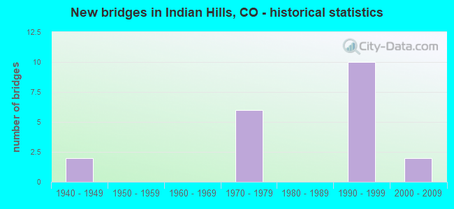
- New bridges - historical statistics
- 21940-1949
- 61970-1979
- 101990-1999
- 22000-2009


- Bridge Condition - Deck
- 55.6%Good
- 33.3%Satisfactory
- 11.1%Fair

- Bridge Condition - Superstructure
- 11.1%Very good
- 55.6%Good
- 22.2%Satisfactory
- 11.1%Fair

- Bridge Condition - Substructure
- 66.7%Good
- 11.1%Satisfactory
- 22.2%Fair

- Bridge Condition - Channel
- 20.0%Very good
- 33.3%Good
- 46.7%Satisfactory

- Bridge Condition - Culverts
- 11.1%Good
- 55.6%Satisfactory
- 33.3%Fair
Find on map >> Show street view
Structure Number: D-16-86, Location: 1.6 MI W OF US285 (Lat: 39.588161, Lng: -105.248953), Route carried "on" structure: County highway , Year Built: 1973, Status: Open, Structure Length: 0.91m (2.99ft), Average Daily Traffic: 1,507 (year 2020), Truck Traffic: 4%, Average Future Daily Traffic: 1,733 (year 2040), Design Load: HL 93, Features Intersected: NORTH TURKEY CREEK, Facility Carried by Structure: COUNTY ROAD 64
Minimum Vertical Clearance: 30+ m (98+ ft), Kilometerpoint: 6.783, Lanes on structure: 2, Owner: County Highway Agency, Approaching Roadway Width: 7.0m (23.0ft), Skew: 4 degrees, Material/Design: Concrete, Design/Construction: Culvert, Number Of Spans In Main Unit: 2, Length of Maximum Span: 4.3m (14.1ft), Out-to-Out Width: 17.7m (58.1ft)
Condition: Channel: Satisfactory, Culverts: Fair, Operating Rating: 55.1 metric tons, Method Used To Determine Operating Rating: Load and Resistance Factor Rating (LRFR) rating reported by rating factor(RF) method using HL-93 loadings, Inventory Rating: 38.9 metric tons, Method Used To Determine Inventory Rating: Load and Resistance Factor Rating (LRFR) rating reported by rating factor(RF) method using HL-93 loadings, Structural Evaluation: Somewhat better than minimum adequacy, Waterway Adequacy: Equal to present desirable criteria, Approach Roadway Alignment: Equal to present minimum criteria, Designated Inspection Frequency: Every 24 months, Inspection Date: Febuary 2021
Find on map >> Show street view
Structure Number: D-16-87, Location: 1.3 MI W OF US285 (Lat: 39.590103, Lng: -105.245211), Route carried "on" structure: County highway , Year Built: 1973, Status: Open, Structure Length: 0.90m (2.95ft), Average Daily Traffic: 1,514 (year 2020), Truck Traffic: 4%, Average Future Daily Traffic: 1,741 (year 2040), Features Intersected: NORTH TURKEY CREEK, Facility Carried by Structure: COUNTY ROAD 64
Minimum Vertical Clearance: 30+ m (98+ ft), Kilometerpoint: 7.541, Lanes on structure: 2, Owner: County Highway Agency, Approaching Roadway Width: 7.0m (23.0ft), Skew: 4 degrees, Material/Design: Concrete, Design/Construction: Culvert, Number Of Spans In Main Unit: 2, Length of Maximum Span: 4.3m (14.1ft), Curb-To-Curb Width: 18.6m (61.0ft), Out-to-Out Width: 26.2m (86.0ft)
Condition: Channel: Satisfactory, Culverts: Fair, Operating Rating: 36.3 metric tons, Method Used To Determine Operating Rating: Field evaluation and documented engineering judgment, Inventory Rating: 32.7 metric tons, Method Used To Determine Inventory Rating: Field evaluation and documented engineering judgment, Structural Evaluation: Somewhat better than minimum adequacy, Deck Geometry: Superior to present desirable criteria, Waterway Adequacy: Better than present minimum criteria, Approach Roadway Alignment: Equal to present desirable criteria, Designated Inspection Frequency: Every 24 months, Inspection Date: April 2021
Find on map >> Show street view
Structure Number: D-16-88, Location: 3.2 MI. W OF US285 (Lat: 39.588647, Lng: -105.266250), Route carried "on" structure: County highway , Year Built: 1995, Status: Open, Structure Length: 0.77m (2.53ft), Average Daily Traffic: 1,586 (year 2020), Truck Traffic: 4%, Average Future Daily Traffic: 1,824 (year 2040), Design Load: HS 20, Features Intersected: PRIVATE DRIVE, Facility Carried by Structure: COUNTY ROAD 64
Minimum Vertical Clearance: 30+ m (98+ ft), Kilometerpoint: 4.635, Lanes on structure: 2, Owner: County Highway Agency, Approaching Roadway Width: 6.9m (22.6ft), Skew: 1 degrees, Material/Design: Concrete, Design/Construction: Culvert, Number Of Spans In Main Unit: 2, Length of Maximum Span: 3.9m (12.8ft), Curb-To-Curb Width: 7.8m (25.6ft), Out-to-Out Width: 12.3m (40.4ft)
Condition: Culverts: Fair, Operating Rating: 78.2 metric tons, Method Used To Determine Operating Rating: Load Factor (LF), Inventory Rating: 46.9 metric tons, Method Used To Determine Inventory Rating: Load Factor (LF), Structural Evaluation: Somewhat better than minimum adequacy, Deck Geometry: Meets minimum limits, Approach Roadway Alignment: Equal to present desirable criteria, Designated Inspection Frequency: Every 24 months, Inspection Date: March 2021
Find on map >> Show street view
Structure Number: E-15-9, Location: 3.9 MI S OF TINYTOWN (Lat: 39.553203, Lng: -105.229397), Route carried "on" structure: County highway , Year Built: 1991, Status: Open, Structure Length: 0.77m (2.53ft), Average Daily Traffic: 933 (year 2020), Truck Traffic: 4%, Average Future Daily Traffic: 1,073 (year 2040), Design Load: HS 20, Features Intersected: SOUTH TURKEY CREEK, Facility Carried by Structure: COUNTY ROAD 122
Minimum Vertical Clearance: 30+ m (98+ ft), Kilometerpoint: 5.264, Lanes on structure: 2, Owner: County Highway Agency, Approaching Roadway Width: 6.7m (22.0ft), Skew: 4 degrees, Material/Design: Concrete, Design/Construction: Frame, Number Of Spans In Main Unit: 1, Length of Maximum Span: 7.1m (23.3ft), Curb-To-Curb Width: 10.0m (32.8ft), Out-to-Out Width: 10.9m (35.8ft)
Condition: Deck: Satisfactory, Superstructure: Satisfactory, Substructure: Good, Channel: Good, Operating Rating: 39.5 metric tons, Method Used To Determine Operating Rating: Load Factor (LF), Inventory Rating: 23.7 metric tons, Method Used To Determine Inventory Rating: Load Factor (LF), Structural Evaluation: Equal to present minimum criteria, Deck Geometry: Equal to present minimum criteria, Waterway Adequacy: Equal to present desirable criteria, Approach Roadway Alignment: Equal to present desirable criteria, Designated Inspection Frequency: Every 24 months, Inspection Date: March 2021, Deck Structure Type: Concrete Cast-file-Place, Wearing Surface/Protective System: Wearing Surface: Bituminous
Find on map >> Show street view
Structure Number: E-15-91, Location: 3 MI S OF TINYTOWN (Lat: 39.563506, Lng: -105.220314), Route carried "on" structure: County highway , Year Built: 1991, Status: Open, Structure Length: 0.77m (2.53ft), Average Daily Traffic: 1,020 (year 2020), Truck Traffic: 4%, Average Future Daily Traffic: 1,173 (year 2040), Design Load: HS 20, Features Intersected: SOUTH TURKEY CREEK, Facility Carried by Structure: COUNTY ROAD 122
Minimum Vertical Clearance: 30+ m (98+ ft), Kilometerpoint: 6.735, Lanes on structure: 2, Owner: County Highway Agency, Approaching Roadway Width: 6.7m (22.0ft), Skew: 4 degrees, Material/Design: Concrete, Design/Construction: Frame, Number Of Spans In Main Unit: 1, Length of Maximum Span: 7.1m (23.3ft), Curb-To-Curb Width: 10.0m (32.8ft), Out-to-Out Width: 10.9m (35.8ft)
Condition: Deck: Good, Superstructure: Good, Substructure: Fair, Channel: Satisfactory, Operating Rating: 36.3 metric tons, Method Used To Determine Operating Rating: Load Factor (LF), Inventory Rating: 21.7 metric tons, Method Used To Determine Inventory Rating: Load Factor (LF), Structural Evaluation: Somewhat better than minimum adequacy, Deck Geometry: Somewhat better than minimum adequacy, Waterway Adequacy: Equal to present desirable criteria, Approach Roadway Alignment: Equal to present desirable criteria, Designated Inspection Frequency: Every 24 months, Inspection Date: March 2021, Deck Structure Type: Other, Wearing Surface/Protective System: Wearing Surface: Bituminous
Find on map >> Show street view
Structure Number: E-15-92, Location: 3.8 MI SOUTH OF TINYTOWN (Lat: 39.555533, Lng: -105.226919), Route carried "on" structure: County highway , Year Built: 1999, Status: Open, Structure Length: 0.82m (2.69ft), Average Daily Traffic: 931 (year 2020), Truck Traffic: 5%, Average Future Daily Traffic: 1,071 (year 2040), Design Load: HS 20, Features Intersected: SOUTH TURKEY CREEK, Facility Carried by Structure: COUNTY ROAD 122
Minimum Vertical Clearance: 30+ m (98+ ft), Kilometerpoint: 5.623, Lanes on structure: 2, Owner: County Highway Agency, Approaching Roadway Width: 6.7m (22.0ft), Skew: 4 degrees, Material/Design: Concrete, Design/Construction: Frame, Number Of Spans In Main Unit: 1, Length of Maximum Span: 7.6m (24.9ft), Curb-To-Curb Width: 10.0m (32.8ft), Out-to-Out Width: 11.0m (36.1ft)
Condition: Deck: Good, Superstructure: Good, Substructure: Good, Channel: Satisfactory, Operating Rating: 62.0 metric tons, Method Used To Determine Operating Rating: Load Factor (LF), Inventory Rating: 37.2 metric tons, Method Used To Determine Inventory Rating: Load Factor (LF), Structural Evaluation: Better than present minimum criteria, Deck Geometry: Equal to present minimum criteria, Waterway Adequacy: Equal to present desirable criteria, Approach Roadway Alignment: Equal to present desirable criteria, Designated Inspection Frequency: Every 24 months, Inspection Date: May 2021, Deck Structure Type: Other, Wearing Surface/Protective System: Wearing Surface: Bituminous
Find on map >> Show street view
Structure Number: E-15-93, Location: 3.75 MI SOUTH OF TINYTOWN (Lat: 39.565639, Lng: -105.221617), Route carried "on" structure: County highway , Year Built: 2000, Status: Open, Structure Length: 0.66m (2.17ft), Average Daily Traffic: 1,031 (year 2020), Truck Traffic: 4%, Average Future Daily Traffic: 1,185 (year 2040), Design Load: HS 20, Features Intersected: SOUTH TURKEY CREEK, Facility Carried by Structure: COUNTY ROAD 122
Minimum Vertical Clearance: 30+ m (98+ ft), Kilometerpoint: 7.007, Lanes on structure: 2, Owner: County Highway Agency, Approaching Roadway Width: 7.6m (24.9ft), Material/Design: Concrete, Design/Construction: Frame, Number Of Spans In Main Unit: 1, Length of Maximum Span: 6.1m (20.0ft), Curb-To-Curb Width: 9.9m (32.5ft), Out-to-Out Width: 10.8m (35.4ft)
Condition: Deck: Good, Superstructure: Good, Substructure: Good, Channel: Satisfactory, Operating Rating: 57.4 metric tons, Method Used To Determine Operating Rating: Load Factor (LF), Inventory Rating: 34.5 metric tons, Method Used To Determine Inventory Rating: Load Factor (LF), Structural Evaluation: Better than present minimum criteria, Deck Geometry: Somewhat better than minimum adequacy, Waterway Adequacy: Equal to present desirable criteria, Approach Roadway Alignment: Equal to present desirable criteria, Designated Inspection Frequency: Every 24 months, Inspection Date: March 2021, Deck Structure Type: Other, Wearing Surface/Protective System: Wearing Surface: Bituminous, Membrane: Built-up
Find on map >> Show street view
Structure Number: E-16-05, Location: 2 MI SOUTH OF TINYTOWN (Lat: 39.581044, Lng: -105.219614), Route carried "on" structure: County highway , Year Built: 2000, Status: Open, Structure Length: 0.97m (3.18ft), Average Daily Traffic: 1,690 (year 2020), Truck Traffic: 4%, Average Future Daily Traffic: 1,944 (year 2040), Design Load: HS 20, Features Intersected: SOUTH TURKEY CREEK, Facility Carried by Structure: COUNTY ROAD 122
Minimum Vertical Clearance: 30+ m (98+ ft), Kilometerpoint: 8.933, Lanes on structure: 2, Owner: County Highway Agency, Approaching Roadway Width: 6.7m (22.0ft), Skew: 3 degrees, Material/Design: Concrete, Design/Construction: Frame, Number Of Spans In Main Unit: 1, Length of Maximum Span: 9.1m (29.9ft), Curb-To-Curb Width: 10.1m (33.1ft), Out-to-Out Width: 10.9m (35.8ft)
Condition: Deck: Good, Superstructure: Good, Substructure: Good, Channel: Very good, Operating Rating: 54.4 metric tons, Method Used To Determine Operating Rating: Load Factor (LF), Inventory Rating: 32.7 metric tons, Method Used To Determine Inventory Rating: Load Factor (LF), Structural Evaluation: Better than present minimum criteria, Deck Geometry: Somewhat better than minimum adequacy, Waterway Adequacy: Equal to present desirable criteria, Approach Roadway Alignment: Equal to present desirable criteria, Designated Inspection Frequency: Every 24 months, Inspection Date: March 2021, Deck Structure Type: Other, Wearing Surface/Protective System: Wearing Surface: Bituminous
Find on map >> Show street view
Structure Number: E-16-88, Location: 1.15 MI W OF US285 (Lat: 39.590792, Lng: -105.240136), Route carried "on" structure: County highway , Year Built: 1973, Status: Open, Structure Length: 0.91m (2.99ft), Average Daily Traffic: 2,432 (year 2020), Truck Traffic: 4%, Average Future Daily Traffic: 2,797 (year 2040), Features Intersected: NORTH TURKEY CREEK, Facility Carried by Structure: COUNTY ROAD 64
Minimum Vertical Clearance: 30+ m (98+ ft), Kilometerpoint: 8.027, Lanes on structure: 2, Owner: County Highway Agency, Approaching Roadway Width: 7.0m (23.0ft), Skew: 4 degrees, Material/Design: Concrete, Design/Construction: Culvert, Number Of Spans In Main Unit: 2, Length of Maximum Span: 4.3m (14.1ft), Out-to-Out Width: 12.6m (41.3ft)
Condition: Channel: Very good, Culverts: Satisfactory, Operating Rating: 36.3 metric tons, Method Used To Determine Operating Rating: Field evaluation and documented engineering judgment, Inventory Rating: 32.7 metric tons, Method Used To Determine Inventory Rating: Field evaluation and documented engineering judgment, Structural Evaluation: Equal to present minimum criteria, Waterway Adequacy: Equal to present desirable criteria, Approach Roadway Alignment: Equal to present desirable criteria, Designated Inspection Frequency: Every 24 months, Inspection Date: April 2021
Find on map >> Show street view
Structure Number: E-16-89, Location: 1.1 MI W OF US285 (Lat: 39.590917, Lng: -105.238944), Route carried "on" structure: County highway , Year Built: 1973, Status: Open, Structure Length: 0.90m (2.95ft), Average Daily Traffic: 2,432 (year 2020), Truck Traffic: 4%, Average Future Daily Traffic: 2,797 (year 2040), Features Intersected: NORTH TURKEY CREEK, Facility Carried by Structure: COUNTY ROAD 64
Minimum Vertical Clearance: 30+ m (98+ ft), Kilometerpoint: 8.132, Lanes on structure: 2, Owner: County Highway Agency, Approaching Roadway Width: 7.0m (23.0ft), Skew: 4 degrees, Material/Design: Concrete, Design/Construction: Culvert, Number Of Spans In Main Unit: 2, Length of Maximum Span: 4.3m (14.1ft), Out-to-Out Width: 11.6m (38.1ft)
Condition: Channel: Satisfactory, Culverts: Satisfactory, Operating Rating: 36.3 metric tons, Method Used To Determine Operating Rating: Field evaluation and documented engineering judgment, Inventory Rating: 32.7 metric tons, Method Used To Determine Inventory Rating: Field evaluation and documented engineering judgment, Structural Evaluation: Equal to present minimum criteria, Waterway Adequacy: Equal to present desirable criteria, Approach Roadway Alignment: Equal to present desirable criteria, Designated Inspection Frequency: Every 24 months, Inspection Date: April 2021
Find on map >> Show street view
Structure Number: E-16-9, Location: .1 MI N OF US285 (Lat: 39.592086, Lng: -105.224167), Route carried "on" structure: County highway , Year Built: 1973, Status: Open, Structure Length: 0.91m (2.99ft), Average Daily Traffic: 2,855 (year 2020), Truck Traffic: 4%, Average Future Daily Traffic: 3,283 (year 2040), Features Intersected: NORTH TURKEY CREEK, Facility Carried by Structure: COUNTY ROAD 64
Minimum Vertical Clearance: 30+ m (98+ ft), Kilometerpoint: 9.718, Lanes on structure: 2, Owner: County Highway Agency, Approaching Roadway Width: 7.0m (23.0ft), Skew: 4 degrees, Material/Design: Concrete, Design/Construction: Culvert, Number Of Spans In Main Unit: 2, Length of Maximum Span: 4.3m (14.1ft), Out-to-Out Width: 22.3m (73.2ft)
Condition: Channel: Good, Culverts: Satisfactory, Operating Rating: 36.3 metric tons, Method Used To Determine Operating Rating: Field evaluation and documented engineering judgment, Inventory Rating: 32.7 metric tons, Method Used To Determine Inventory Rating: Field evaluation and documented engineering judgment, Structural Evaluation: Equal to present minimum criteria, Waterway Adequacy: Equal to present desirable criteria, Approach Roadway Alignment: Equal to present desirable criteria, Designated Inspection Frequency: Every 24 months, Inspection Date: April 2021
Find on map >> Show street view
Structure Number: E-16-91, Location: .7 MI S OF TINYTOWN (Lat: 39.593361, Lng: -105.219403), Route carried "on" structure: County highway , Year Built: 1991, Status: Open, Structure Length: 0.87m (2.85ft), Average Daily Traffic: 860 (year 2020), Truck Traffic: 4%, Average Future Daily Traffic: 989 (year 2040), Design Load: HS 20, Features Intersected: SOUTH TURKEY CREEK, Facility Carried by Structure: COUNTY ROAD 122
Minimum Vertical Clearance: 30+ m (98+ ft), Kilometerpoint: 10.422, Lanes on structure: 2, Owner: County Highway Agency, Approaching Roadway Width: 6.7m (22.0ft), Skew: 4 degrees, Material/Design: Concrete, Design/Construction: Frame, Number Of Spans In Main Unit: 1, Length of Maximum Span: 8.3m (27.2ft), Curb-To-Curb Width: 9.9m (32.5ft), Out-to-Out Width: 10.8m (35.4ft)
Condition: Deck: Fair, Superstructure: Fair, Substructure: Satisfactory, Channel: Good, Operating Rating: 53.0 metric tons, Method Used To Determine Operating Rating: Load Factor (LF), Inventory Rating: 31.8 metric tons, Method Used To Determine Inventory Rating: Load Factor (LF), Structural Evaluation: Somewhat better than minimum adequacy, Deck Geometry: Equal to present minimum criteria, Waterway Adequacy: Equal to present desirable criteria, Approach Roadway Alignment: Equal to present desirable criteria, Designated Inspection Frequency: Every 24 months, Inspection Date: March 2021, Deck Structure Type: Other, Wearing Surface/Protective System: Wearing Surface: Bituminous
Find on map >> Show street view
Structure Number: E-17-11, Location: JUST SOUTH OF US285 (Lat: 39.611831, Lng: -105.230731), Route carried "on" structure: County highway , Year Built: 1948, Status: Open, Structure Length: 1.18m (3.87ft), Average Daily Traffic: 1,204 (year 2020), Truck Traffic: 4%, Average Future Daily Traffic: 1,384 (year 2040), Features Intersected: TURKEY CREEK, Facility Carried by Structure: COUNTY ROAD 122
Minimum Vertical Clearance: 30+ m (98+ ft), Kilometerpoint: 12.858, Lanes on structure: 2, Owner: County Highway Agency, Approaching Roadway Width: 7.3m (24.0ft), Skew: 1 degrees, Material/Design: Steel, Design/Construction: Stringer/Multi-beam, Number Of Spans In Main Unit: 1, Length of Maximum Span: 10.4m (34.1ft), Curb-To-Curb Width: 9.1m (29.9ft), Out-to-Out Width: 10.5m (34.4ft)
Condition: Deck: Satisfactory, Superstructure: Satisfactory, Substructure: Fair, Channel: Good, Operating Rating: 33.0 metric tons, Method Used To Determine Operating Rating: Load Factor (LF), Inventory Rating: 22.2 metric tons, Method Used To Determine Inventory Rating: Load Factor (LF), Structural Evaluation: Somewhat better than minimum adequacy, Deck Geometry: Somewhat better than minimum adequacy, Waterway Adequacy: Equal to present desirable criteria, Approach Roadway Alignment: Equal to present minimum criteria, Designated Inspection Frequency: Every 24 months, Inspection Date: March 2021, Deck Structure Type: Concrete Cast-file-Place, Wearing Surface/Protective System: Wearing Surface: Bituminous
Find on map >> Show street view
Structure Number: E-17-85, Location: TINYTOWN (Lat: 39.601708, Lng: -105.223639), Route carried "on" structure: County highway , Year Built: 1973, Status: Open, Structure Length: 1.51m (4.95ft), Average Daily Traffic: 116 (year 2020), Truck Traffic: 4%, Average Future Daily Traffic: 133 (year 2040), Features Intersected: NORTH TURKEY CREEK, Facility Carried by Structure: ROSS ROAD
Minimum Vertical Clearance: 30+ m (98+ ft), Kilometerpoint: 0.512, Lanes on structure: 2, Owner: County Highway Agency, Approaching Roadway Width: 8.5m (27.9ft), Skew: 5 degrees, Material/Design: Concrete, Design/Construction: Culvert, Number Of Spans In Main Unit: 3, Length of Maximum Span: 5.7m (18.7ft), Out-to-Out Width: 12.1m (39.7ft)
Condition: Channel: Satisfactory, Culverts: Satisfactory, Operating Rating: 36.3 metric tons, Method Used To Determine Operating Rating: Field evaluation and documented engineering judgment, Inventory Rating: 32.7 metric tons, Method Used To Determine Inventory Rating: Field evaluation and documented engineering judgment, Structural Evaluation: Equal to present minimum criteria, Waterway Adequacy: Equal to present desirable criteria, Approach Roadway Alignment: Equal to present desirable criteria, Designated Inspection Frequency: Every 24 months, Inspection Date: Febuary 2021
Find on map >> Show street view
Structure Number: F-16-AV, Location: 6 MI W OF C470 (Lat: 39.592411, Lng: -105.222253), Route carried "on" structure: US 285D, Year Built: 1948, Status: Open, Structure Length: 0.76m (2.49ft), Average Daily Traffic: 26,000 (year 2020), Truck Traffic: 4%, Average Future Daily Traffic: 32,240 (year 2040), Design Load: HS 20, Features Intersected: NORTH TURKEY CREEK, Facility Carried by Structure: US 285 ML
Minimum Vertical Clearance: 30+ m (98+ ft), Kilometerpoint: 132.161, Lanes on structure: 8, Base Highway Network: Yes, Owner: State Highway Agency, Approaching Roadway Width: 32.9m (107.9ft), Material/Design: Concrete, Design/Construction: Culvert, Number Of Spans In Main Unit: 1, Length of Maximum Span: 7.6m (24.9ft)
Condition: Channel: Very good, Culverts: Satisfactory, Operating Rating: 89.8 metric tons, Method Used To Determine Operating Rating: Load Factor (LF), Inventory Rating: 89.8 metric tons, Method Used To Determine Inventory Rating: Load Factor (LF), Structural Evaluation: Equal to present minimum criteria, Waterway Adequacy: Superior to present desirable criteria, Approach Roadway Alignment: Equal to present desirable criteria, Designated Inspection Frequency: Every 24 months, Inspection Date: August 2021
Find on map >> Show street view
Structure Number: F-16-SB, Location: 4.4 MILES SW OF SH 8 (Lat: 39.591150, Lng: -105.221550), Route carried "on" structure: US 285D, Year Built: 1995, Status: Open, Structure Length: 7.38m (24.21ft), Average Daily Traffic: 26,000 (year 2020), Truck Traffic: 4%, Average Future Daily Traffic: 32,240 (year 2040), Design Load: HS 20, Features Intersected: NORTH TURKEY CREEK ROAD, Facility Carried by Structure: US 285 ML
Minimum Vertical Clearance: 30+ m (98+ ft), Kilometerpoint: 132.005, Lanes on structure: 6, Lanes under structure: 2, Base Highway Network: Yes, Owner: State Highway Agency, Approaching Roadway Width: 34.1m (111.9ft), Skew: 9 degrees, Material/Design: Prestressed concrete, Design/Construction: Box Beam or Girders - Multiple, Number Of Spans In Main Unit: 3, Length of Maximum Span: 33.2m (108.9ft), Curb-To-Curb Width: 34.1m (111.9ft), Out-to-Out Width: 35.5m (116.5ft)
Condition: Deck: Satisfactory, Superstructure: Good, Substructure: Good, Operating Rating: 59.7 metric tons, Method Used To Determine Operating Rating: Load Factor (LF), Inventory Rating: 35.7 metric tons, Method Used To Determine Inventory Rating: Load Factor (LF), Structural Evaluation: Better than present minimum criteria, Deck Geometry: Superior to present desirable criteria, Underclear: Meets minimum limits, Approach Roadway Alignment: Equal to present desirable criteria, Designated Inspection Frequency: Every 24 months, Inspection Date: August 2021, Deck Structure Type: Concrete Cast-file-Place, Wearing Surface/Protective System: Wearing Surface: Monolithic Concrete, Deck Protection: Epoxy Coated Reinforcing
Find on map >> Show street view
Structure Number: F-16-SN, Location: 2.5 MILES SW OF SH 8 (Lat: 39.615183, Lng: -105.233156), Route carried "on" structure: Ramp US 285D, Year Built: 1993, Status: Open, Structure Length: 7.00m (22.97ft), Average Daily Traffic: 27,000 (year 2020), Truck Traffic: 3%, Average Future Daily Traffic: 34,020 (year 2040), Design Load: HS 20+Mod, Features Intersected: US 285 ML, Facility Carried by Structure: PARMALEE GULCH RD.
Minimum Vertical Clearance: 30+ m (98+ ft), Kilometerpoint: 0.124, Lanes on structure: 1, Lanes under structure: 6, Base Highway Network: Yes, Owner: State Highway Agency, Approaching Roadway Width: 7.6m (24.9ft), Skew: 9 degrees, Material/Design: Steel continuous, Design/Construction: Stringer/Multi-beam, Number Of Spans In Main Unit: 2, Length of Maximum Span: 37.0m (121.4ft), Curb-To-Curb Width: 7.6m (24.9ft), Out-to-Out Width: 8.4m (27.6ft)
Condition: Deck: Good, Superstructure: Very good, Substructure: Good, Operating Rating: 58.3 metric tons, Method Used To Determine Operating Rating: Load and Resistance Factor Rating (LRFR) rating reported by rating factor(RF) method using HL-93 loadings, Inventory Rating: 45.0 metric tons, Method Used To Determine Inventory Rating: Load and Resistance Factor Rating (LRFR) rating reported by rating factor(RF) method using HL-93 loadings, Structural Evaluation: Better than present minimum criteria, Deck Geometry: Better than present minimum criteria, Underclear: Equal to present minimum criteria, Approach Roadway Alignment: Equal to present desirable criteria, Designated Inspection Frequency: Every 24 months, Inspection Date: August 2021, Deck Structure Type: Concrete Cast-file-Place, Wearing Surface/Protective System: Wearing Surface: Bituminous, Membrane: Built-up, Deck Protection: Epoxy Coated Reinforcing
Find on map >> Show street view
Structure Number: F-16-SO, Location: INDIAN HILLS RD INTSCTN (Lat: 39.615697, Lng: -105.234142), Route carried "on" structure: Ramp US 285D, Year Built: 1993, Status: Open, Structure Length: 1.29m (4.23ft), Average Daily Traffic: 13,500 (year 2020), Truck Traffic: 3%, Average Future Daily Traffic: 17,010 (year 2040), Design Load: HS 20, Features Intersected: PARMALEE GULCH R, Facility Carried by Structure: RAMP TO US 285 NBD
Minimum Vertical Clearance: 30+ m (98+ ft), Kilometerpoint: 0.023, Lanes on structure: 1, Base Highway Network: Yes, Owner: State Highway Agency, Approaching Roadway Width: 7.6m (24.9ft), Skew: 2 degrees, Material/Design: Concrete, Design/Construction: Culvert, Number Of Spans In Main Unit: 3, Length of Maximum Span: 4.8m (15.7ft), Out-to-Out Width: 17.5m (57.4ft)
Condition: Channel: Good, Culverts: Good, Operating Rating: 36.3 metric tons, Method Used To Determine Operating Rating: Field evaluation and documented engineering judgment, Inventory Rating: 32.7 metric tons, Method Used To Determine Inventory Rating: Field evaluation and documented engineering judgment, Structural Evaluation: Better than present minimum criteria, Waterway Adequacy: Equal to present desirable criteria, Approach Roadway Alignment: Equal to present desirable criteria, Designated Inspection Frequency: Every 48 months, Inspection Date: August 2019
Find on map >> Show street view
Structure Number: D-16-88, Location: 3.2 MI. W OF US285 (Lat: 39.588647, Lng: -105.266250), Route carried "under" structure: ServiceOther road , Year Built: 1995, Structure Length: 0. m, Average Daily Traffic: 10 (year 2003), Features Intersected: PRIVATE DRIVE, Facility Carried by Structure: COUNTY ROAD 64
Minimum Vertical Clearance: 30+ m (98+ ft), Kilometerpoint: 0.000, Lanes on structure: 2, Material/Design: Concrete, Design/Construction: Culvert, Length of Maximum Span: 3.9m (12.8ft)
Find on map >> Show street view
Structure Number: F-16-SN, Location: 2.5 MILES SW OF SH 8 (Lat: 39.615183, Lng: -105.233156), Route carried "under" structure: US 285D, Year Built: 1993, Structure Length: 0. m, Average Daily Traffic: 22,000 (year 2011), Truck Traffic: 3%, Features Intersected: US 285 ML, Facility Carried by Structure: PARMALEE GULCH RD.
Minimum Vertical Clearance: 5.59m (18.34ft), Kilometerpoint: 395.605, Lanes on structure: 1, Lanes under structure: 6, Material/Design: Steel continuous, Design/Construction: Stringer/Multi-beam, Length of Maximum Span: 37.0m (121.4ft)