Bridge Statistics for Indian Lake, New York (NY)
Condition, Traffic, Stress, Structural Evaluation, Project Costs
- National Bridge Inventory (NBI) Statistics
- 17Number of bridges
- 98ft / 30.4mTotal length
- $13,009,000Total costs
- 13,211Total average daily traffic
- 1,426Total average daily truck traffic
- 14,214Total future (year 2016) average daily traffic
- National Bridge Inventory (NBI) Registered Bridges for Indian Lake
- No street view available for this location
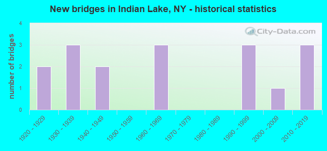
- New bridges - historical statistics
- 21920-1929
- 31930-1939
- 21940-1949
- 31960-1969
- 31990-1999
- 12000-2009
- 32010-2019

- Reconstructed bridges - Historical Statistics
- 11990-1999
- 12000-2009
- 12010-2019

- Bridge Condition - Deck
- 14.3%Excellent
- 35.7%Very good
- 28.6%Good
- 21.4%Satisfactory

- Bridge Condition - Superstructure
- 35.7%Excellent
- 14.3%Very good
- 28.6%Good
- 21.4%Satisfactory

- Bridge Condition - Substructure
- 14.3%Excellent
- 7.1%Very good
- 21.4%Good
- 35.7%Satisfactory
- 14.3%Fair
- 7.1%Failed

- Bridge Condition - Channel
- 11.8%Excellent
- 17.6%Very good
- 29.4%Good
- 23.5%Satisfactory
- 17.6%Fair

- Bridge Condition - Culverts
- 33.3%Very good
- 33.3%Satisfactory
- 33.3%Fair
Find on map >> Show street view
Structure Number: 102029, Location: 3.7 MI W JCT RTS 28 & 28N (Lat: 43.831528, Lng: -74.499153), Route carried "on" structure: State highway 28, Year Built: 1929, Status: Open, Structure Length: 1.04m (3.41ft), Average Daily Traffic: 1,025 (year 2018), Truck Traffic: 15%, Average Future Daily Traffic: 1,031 (year 2040), Design Load: H 15, Features Intersected: LOON BROOK
Minimum Vertical Clearance: 30+ m (98+ ft), Kilometerpoint: 34.706, Lanes on structure: 2, Base Highway Network: Yes, Owner: State Highway Agency, Approaching Roadway Width: 9.1m (29.9ft), Skew: 3 degrees, Material/Design: Concrete, Design/Construction: Tee Beam, Number Of Spans In Main Unit: 1, Length of Maximum Span: 9.1m (29.9ft), Curb-To-Curb Width: 9.2m (30.2ft), Out-to-Out Width: 10.1m (33.1ft)
Condition: Deck: Satisfactory, Superstructure: Good, Substructure: Satisfactory, Channel: Satisfactory, Operating Rating: 67.1 metric tons, Method Used To Determine Operating Rating: Load Factor (LF), Inventory Rating: 39.9 metric tons, Method Used To Determine Inventory Rating: Load Factor (LF), Structural Evaluation: Equal to present minimum criteria, Deck Geometry: Somewhat better than minimum adequacy, Waterway Adequacy: Meets minimum limits, Approach Roadway Alignment: Equal to present desirable criteria, Length Of Structure Improvement: 1.03m (3.38ft), Designated Inspection Frequency: Every 24 months, Inspection Date: October 2020, Bridge Improvement Cost: $392,000, Roadway Improvement Cost: $230,000, Total Project Cost: $622,000 ( Estimate for 2021), Wearing Surface/Protective System: Wearing Surface: Bituminous, Membrane: Other
Find on map >> Show street view
Structure Number: 10203, Location: 29 SE JCT RTS 28+28N (Lat: 43.840756, Lng: -74.383156), Route carried "on" structure: State highway 28, Year Built: 1961, Status: Open, Structure Length: 1.46m (4.79ft), Average Daily Traffic: 1,920 (year 2019), Truck Traffic: 12%, Average Future Daily Traffic: 2,070 (year 2040), Design Load: H 15, Features Intersected: ROCK RIVER
Minimum Vertical Clearance: 30+ m (98+ ft), Kilometerpoint: 45.873, Lanes on structure: 2, Base Highway Network: Yes, Owner: State Highway Agency, Approaching Roadway Width: 12.8m (42.0ft), Skew: 4 degrees, Material/Design: Steel, Design/Construction: Culvert, Number Of Spans In Main Unit: 2, Length of Maximum Span: 6.0m (19.7ft)
Condition: Channel: Good, Culverts: Fair, Operating Rating: 50.1 metric tons, Method Used To Determine Operating Rating: Field evaluation and documented engineering judgment, Inventory Rating: 14.7 metric tons, Method Used To Determine Inventory Rating: Field evaluation and documented engineering judgment, Structural Evaluation: Meets minimum limits, Waterway Adequacy: Somewhat better than minimum adequacy, Approach Roadway Alignment: Equal to present desirable criteria, Length Of Structure Improvement: 1.46m (4.79ft), Designated Inspection Frequency: Every 24 months, Inspection Date: November 2020, Bridge Improvement Cost: $365,000, Roadway Improvement Cost: $214,000, Total Project Cost: $578,000 ( Estimate for 2021)
Find on map >> Show street view
Structure Number: 102031, Location: 1.8 MI NW JCT RTS 28+30 (Lat: 43.781117, Lng: -74.299878), Route carried "on" structure: State highway 28, Year Built: 1992, Status: Open, Structure Length: 5.09m (16.70ft), Average Daily Traffic: 1,920 (year 2019), Truck Traffic: 12%, Average Future Daily Traffic: 2,070 (year 2040), Design Load: HS 20, Features Intersected: CEDAR RIVER
Minimum Vertical Clearance: 30+ m (98+ ft), Kilometerpoint: 56.524, Lanes on structure: 2, Base Highway Network: Yes, Owner: State Highway Agency, Approaching Roadway Width: 10.4m (34.1ft), Skew: 4 degrees, Material/Design: Steel, Design/Construction: Stringer/Multi-beam, Number Of Spans In Main Unit: 1, Length of Maximum Span: 48.7m (159.8ft), Curb-To-Curb Width: 10.4m (34.1ft), Out-to-Out Width: 11.0m (36.1ft)
Condition: Deck: Good, Superstructure: Good, Substructure: Good, Channel: Excellent, Operating Rating: 89.8 metric tons, Method Used To Determine Operating Rating: Load Factor (LF), Inventory Rating: 35.4 metric tons, Method Used To Determine Inventory Rating: Load Factor (LF), Structural Evaluation: Better than present minimum criteria, Deck Geometry: Equal to present minimum criteria, Waterway Adequacy: Equal to present desirable criteria, Approach Roadway Alignment: Equal to present desirable criteria, Length Of Structure Improvement: 5.09m (16.70ft), Designated Inspection Frequency: Every 24 months, Inspection Date: October 2020, Bridge Improvement Cost: $1,310,000, Roadway Improvement Cost: $767,000, Total Project Cost: $2,076,000 ( Estimate for 2021), Deck Structure Type: Concrete Cast-file-Place, Wearing Surface/Protective System: Wearing Surface: Integral Concrete, Deck Protection: Epoxy Coated Reinforcing
Find on map >> Show street view
Structure Number: 102032, Location: 1.3MI E OF JCT RTS 28 &30 (Lat: 43.784989, Lng: -74.239983), Route carried "on" structure: State highway 28, Year Built: 1995, Status: Open, Structure Length: 6.55m (21.49ft), Average Daily Traffic: 2,177 (year 2019), Truck Traffic: 10%, Average Future Daily Traffic: 2,190 (year 2040), Design Load: HS 25 or greater, Features Intersected: LAKE ABANAKEE
Minimum Vertical Clearance: 30+ m (98+ ft), Kilometerpoint: 61.657, Lanes on structure: 2, Base Highway Network: Yes, Owner: State Highway Agency, Approaching Roadway Width: 11.0m (36.1ft), Material/Design: Steel continuous, Design/Construction: Stringer/Multi-beam, Number Of Spans In Main Unit: 2, Length of Maximum Span: 32.0m (105.0ft), Curb-To-Curb Width: 11.0m (36.1ft), Out-to-Out Width: 11.6m (38.1ft)
Condition: Deck: Satisfactory, Superstructure: Very good, Substructure: Satisfactory, Channel: Very good, Operating Rating: 89.8 metric tons, Method Used To Determine Operating Rating: Load Factor (LF), Inventory Rating: 68.0 metric tons, Method Used To Determine Inventory Rating: Load Factor (LF), Structural Evaluation: Equal to present minimum criteria, Deck Geometry: Somewhat better than minimum adequacy, Waterway Adequacy: Equal to present minimum criteria, Approach Roadway Alignment: Equal to present desirable criteria, Length Of Structure Improvement: 6.55m (21.49ft), Designated Inspection Frequency: Every 24 months, Underwater Inspection Frequency: Every 60 months, Inspection Date: October 2020, Underwater Inspection Date: July 2019, Bridge Improvement Cost: $1,357,000, Roadway Improvement Cost: $794,000, Total Project Cost: $2,151,000 ( Estimate for 2021), Deck Structure Type: Concrete Cast-file-Place, Wearing Surface/Protective System: Wearing Surface: Integral Concrete, Deck Protection: Epoxy Coated Reinforcing
Find on map >> Show street view
Structure Number: 102046, Location: 4.2 MI N JCT SH28N & SH28 (Lat: 43.903278, Lng: -74.436703), Route carried "on" structure: State highway 30, Year Built: 1930, Year Reconstructed: 2005, Status: Open, Structure Length: 1.13m (3.71ft), Average Daily Traffic: 1,205 (year 2018), Truck Traffic: 8%, Average Future Daily Traffic: 1,299 (year 2040), Design Load: HS 25 or greater, Features Intersected: SALMON RIVER
Minimum Vertical Clearance: 30+ m (98+ ft), Kilometerpoint: 7.208, Lanes on structure: 2, Base Highway Network: Yes, Owner: State Highway Agency, Approaching Roadway Width: 9.1m (29.9ft), Skew: 3 degrees, Material/Design: Concrete, Design/Construction: Box Beam or Girders - Multiple, Number Of Spans In Main Unit: 1, Length of Maximum Span: 10.2m (33.5ft), Curb-To-Curb Width: 9.0m (29.5ft), Out-to-Out Width: 10.0m (32.8ft)
Condition: Deck: Good, Superstructure: Excellent, Substructure: Satisfactory, Channel: Good, Operating Rating: 78.0 metric tons, Method Used To Determine Operating Rating: Load Factor (LF), Inventory Rating: 38.1 metric tons, Method Used To Determine Inventory Rating: Load Factor (LF), Structural Evaluation: Equal to present minimum criteria, Deck Geometry: Somewhat better than minimum adequacy, Waterway Adequacy: Somewhat better than minimum adequacy, Approach Roadway Alignment: Better than present minimum criteria, Length Of Structure Improvement: 1.12m (3.67ft), Designated Inspection Frequency: Every 24 months, Inspection Date: October 2021, Bridge Improvement Cost: $413,000, Roadway Improvement Cost: $242,000, Total Project Cost: $655,000 ( Estimate for 2021), Wearing Surface/Protective System: Wearing Surface: Monolithic Concrete
Find on map >> Show street view
Structure Number: 102123, Location: 20 MI N JCT SH 8 & SH 30 (Lat: 43.740861, Lng: -74.295069), Route carried "on" structure: State highway 30, Year Built: 1931, Status: Open, Structure Length: 1.01m (3.31ft), Average Daily Traffic: 834 (year 2019), Truck Traffic: 12%, Average Future Daily Traffic: 899 (year 2040), Design Load: H 15, Features Intersected: SQUAW BROOK
Minimum Vertical Clearance: 30+ m (98+ ft), Kilometerpoint: 75.044, Lanes on structure: 2, Base Highway Network: Yes, Owner: State Highway Agency, Approaching Roadway Width: 7.9m (25.9ft), Material/Design: Concrete, Design/Construction: Tee Beam, Number Of Spans In Main Unit: 1, Length of Maximum Span: 9.1m (29.9ft), Curb-To-Curb Width: 7.9m (25.9ft), Out-to-Out Width: 8.8m (28.9ft)
Condition: Deck: Good, Superstructure: Good, Substructure: Fair, Channel: Satisfactory, Operating Rating: 49.9 metric tons, Method Used To Determine Operating Rating: Load and Resistance Factor Rating (LRFR) rating reported by rating factor(RF) method using HL-93 loadings, Inventory Rating: 38.6 metric tons, Method Used To Determine Inventory Rating: Load and Resistance Factor Rating (LRFR) rating reported by rating factor(RF) method using HL-93 loadings, Structural Evaluation: Somewhat better than minimum adequacy, Deck Geometry: Somewhat better than minimum adequacy, Waterway Adequacy: Somewhat better than minimum adequacy, Approach Roadway Alignment: Equal to present desirable criteria, Length Of Structure Improvement: 1.00m (3.28ft), Designated Inspection Frequency: Every 24 months, Inspection Date: October 2020, Bridge Improvement Cost: $312,000, Roadway Improvement Cost: $183,000, Total Project Cost: $494,000 ( Estimate for 2021), Wearing Surface/Protective System: Wearing Surface: Bituminous
Find on map >> Show street view
Structure Number: 10794, Location: 16.9 mi N Jct Rts 8 & 30 (Lat: 43.707708, Lng: -74.332017), Route carried "on" structure: State highway 30, Year Built: 2013, Status: Open, Structure Length: 0.82m (2.69ft), Average Daily Traffic: 834 (year 2019), Truck Traffic: 12%, Average Future Daily Traffic: 899 (year 2040), Design Load: HL 93, Features Intersected: Beaver Brook
Minimum Vertical Clearance: 30+ m (98+ ft), Kilometerpoint: 70.008, Lanes on structure: 2, Base Highway Network: Yes, Owner: State Highway Agency, Approaching Roadway Width: 10.4m (34.1ft), Material/Design: Concrete, Design/Construction: Culvert, Number Of Spans In Main Unit: 1, Length of Maximum Span: 7.6m (24.9ft), Curb-To-Curb Width: 10.4m (34.1ft), Out-to-Out Width: 11.5m (37.7ft)
Condition: Channel: Good, Culverts: Very good, Operating Rating: 55.4 metric tons, Method Used To Determine Operating Rating: Load and Resistance Factor Rating (LRFR) rating reported by rating factor(RF) method using HL-93 loadings, Inventory Rating: 42.8 metric tons, Method Used To Determine Inventory Rating: Load and Resistance Factor Rating (LRFR) rating reported by rating factor(RF) method using HL-93 loadings, Structural Evaluation: Equal to present desirable criteria, Deck Geometry: Equal to present minimum criteria, Waterway Adequacy: Somewhat better than minimum adequacy, Approach Roadway Alignment: Equal to present desirable criteria, Length Of Structure Improvement: 0.82m (2.69ft), Designated Inspection Frequency: Every 24 months, Inspection Date: June 2021, Bridge Improvement Cost: $184,000, Roadway Improvement Cost: $107,000, Total Project Cost: $291,000 ( Estimate for 2021)
Find on map >> Show street view
Structure Number: 108067, Location: 28 28 22091487_ALDUOS BR (Lat: 43.750994, Lng: -74.058758), Route carried "on" structure: State highway 28, Year Built: 1962, Status: Open, Structure Length: 0.70m (2.30ft), Average Daily Traffic: 2,177 (year 2019), Truck Traffic: 10%, Average Future Daily Traffic: 2,190 (year 2040), Design Load: HS 20, Features Intersected: Aldous Brook
Minimum Vertical Clearance: 32.69m (107.25ft), Kilometerpoint: 78.294, Lanes on structure: 2, Owner: State Highway Agency, Approaching Roadway Width: 12.2m (40.0ft), Skew: 3 degrees, Material/Design: Concrete, Design/Construction: Culvert, Number Of Spans In Main Unit: 1, Length of Maximum Span: 6.4m (21.0ft), Curb-To-Curb Width: 16.6m (54.5ft), Out-to-Out Width: 17.6m (57.7ft)
Condition: Channel: Fair, Culverts: Satisfactory, Operating Rating: 68.0 metric tons, Method Used To Determine Operating Rating: Load Factor (LF), Inventory Rating: 39.9 metric tons, Method Used To Determine Inventory Rating: Load Factor (LF), Structural Evaluation: Equal to present minimum criteria, Deck Geometry: Superior to present desirable criteria, Waterway Adequacy: Equal to present desirable criteria, Approach Roadway Alignment: Equal to present desirable criteria, Designated Inspection Frequency: Every 24 months, Inspection Date: May 2021
Find on map >> Show street view
Structure Number: 220453, Location: 4 MILES SW OF INDIAN LAKE (Lat: 43.738758, Lng: -74.228031), Route carried "on" structure: Other road , Year Built: 1922, Year Reconstructed: 2010, Status: Open, Structure Length: 0.70m (2.30ft), Average Daily Traffic: 10 (year 2017), Truck Traffic: 4%, Average Future Daily Traffic: 14 (year 2037), Features Intersected: RAINBOW LK OUTLET, Facility Carried by Structure: MCCORMICK ROAD
Minimum Vertical Clearance: 30+ m (98+ ft), Kilometerpoint: 0.016, Lanes on structure: 1, Owner: County Highway Agency, Approaching Roadway Width: 4.3m (14.1ft), Material/Design: Wood or Timber, Design/Construction: Slab, Number Of Spans In Main Unit: 1, Length of Maximum Span: 6.4m (21.0ft), Curb-To-Curb Width: 4.3m (14.1ft), Out-to-Out Width: 4.9m (16.1ft)
Condition: Deck: Very good, Superstructure: Excellent, Substructure: Good, Channel: Very good, Inventory Rating: 88.0 metric tons, Method Used To Determine Inventory Rating: Allowable Stress (AS), Structural Evaluation: Better than present minimum criteria, Deck Geometry: Equal to present minimum criteria, Waterway Adequacy: Somewhat better than minimum adequacy, Approach Roadway Alignment: Equal to present minimum criteria, Length Of Structure Improvement: 0.70m (2.30ft), Designated Inspection Frequency: Every 24 months, Inspection Date: September 2020, Bridge Improvement Cost: $121,000, Roadway Improvement Cost: $71,000, Total Project Cost: $192,000 ( Estimate for 2021), Wearing Surface/Protective System: Wearing Surface: Bituminous
Find on map >> Show street view
Structure Number: 220454, Location: 2.5 MI SE VILL INDIAN LK (Lat: 43.752061, Lng: -74.236817), Route carried "on" structure: Other road , Year Built: 2007, Status: Open, Structure Length: 1.13m (3.71ft), Average Daily Traffic: 16 (year 2018), Average Future Daily Traffic: 22 (year 2038), Design Load: HS 25 or greater, Features Intersected: BIG BROOK, Facility Carried by Structure: CORSCADDEN ROAD
Minimum Vertical Clearance: 30+ m (98+ ft), Kilometerpoint: 0.998, Lanes on structure: 2, Owner: County Highway Agency, Approaching Roadway Width: 6.7m (22.0ft), Material/Design: Steel, Design/Construction: Stringer/Multi-beam, Number Of Spans In Main Unit: 1, Length of Maximum Span: 11.0m (36.1ft), Curb-To-Curb Width: 6.7m (22.0ft), Out-to-Out Width: 7.3m (24.0ft)
Condition: Deck: Very good, Superstructure: Excellent, Substructure: Excellent, Channel: Satisfactory, Operating Rating: 55.3 metric tons, Method Used To Determine Operating Rating: Allowable Stress (AS), Inventory Rating: 41.7 metric tons, Method Used To Determine Inventory Rating: Allowable Stress (AS), Structural Evaluation: Superior to present desirable criteria, Deck Geometry: Somewhat better than minimum adequacy, Waterway Adequacy: Meets minimum limits, Approach Roadway Alignment: Equal to present minimum criteria, Length Of Structure Improvement: 1.12m (3.67ft), Designated Inspection Frequency: Every 24 months, Inspection Date: August 2021, Bridge Improvement Cost: $145,000, Roadway Improvement Cost: $85,000, Total Project Cost: $229,000 ( Estimate for 2021), Deck Structure Type: Wood or Timber, Wearing Surface/Protective System: Wearing Surface: Wood or Timber
Find on map >> Show street view
Structure Number: 22637, Location: 10.3 MI NW OF INDIAN LAKE (Lat: 43.837639, Lng: -74.385519), Route carried "on" structure: State lands road , Year Built: 1935, Status: Open, Structure Length: 1.31m (4.30ft), Average Daily Traffic: 15 (year 1996), Truck Traffic: 6%, Average Future Daily Traffic: 21 (year 2016), Features Intersected: STEPHENS POND OUT, Facility Carried by Structure: CONSERV DEPT ROAD
Minimum Vertical Clearance: 30+ m (98+ ft), Kilometerpoint: 0.000, Lanes on structure: 2, Owner: State Agenciy, Approaching Roadway Width: 4.6m (15.1ft), Skew: 2 degrees, Material/Design: Steel, Design/Construction: Stringer/Multi-beam, Number Of Spans In Main Unit: 1, Length of Maximum Span: 11.6m (38.1ft), Curb-To-Curb Width: 6.0m (19.7ft), Out-to-Out Width: 6.6m (21.7ft)
Condition: Deck: Very good, Superstructure: Satisfactory, Substructure: Satisfactory, Channel: Good, Operating Rating: 58.1 metric tons, Method Used To Determine Operating Rating: Load Factor (LF), Inventory Rating: 34.5 metric tons, Method Used To Determine Inventory Rating: Load Factor (LF), Structural Evaluation: Equal to present minimum criteria, Deck Geometry: Meets minimum limits, Waterway Adequacy: Equal to present minimum criteria, Approach Roadway Alignment: Meets minimum limits, Length Of Structure Improvement: 1.31m (4.30ft), Designated Inspection Frequency: Every 24 months, Inspection Date: October 2021, Bridge Improvement Cost: $239,000, Roadway Improvement Cost: $140,000, Total Project Cost: $378,000 ( Estimate for 2021), Deck Structure Type: Wood or Timber, Wearing Surface/Protective System: Wearing Surface: Bituminous
Find on map >> Show street view
Structure Number: 226874, Location: OFF CHIMNEY MTN ROAD (Lat: 43.704878, Lng: -74.248422), Route carried "on" structure: State lands road , Year Built: 1995, Status: Closed, Structure Length: 1.83m (6.00ft), Truck Traffic: 4%, Design Load: HS 20, Features Intersected: ROUND LAKE OUTLET, Facility Carried by Structure: NYSDEC ROAD
Minimum Vertical Clearance: 30+ m (98+ ft), Kilometerpoint: 0.209, Lanes on structure: 1, Owner: State Agenciy, Approaching Roadway Width: 3.7m (12.1ft), Material/Design: Steel, Design/Construction: Stringer/Multi-beam, Number Of Spans In Main Unit: 1, Length of Maximum Span: 17.9m (58.7ft), Curb-To-Curb Width: 3.8m (12.5ft), Out-to-Out Width: 4.3m (14.1ft)
Condition: Deck: Very good, Superstructure: Satisfactory, Substructure: Failed, Channel: Good, Deck Geometry: Meets minimum limits, Waterway Adequacy: Equal to present minimum criteria, Approach Roadway Alignment: Equal to present minimum criteria, Bridge Posting: Required (Relationship of Operating Rating to Maximum Legal Load: > 39.9% below), Length Of Structure Improvement: 1.82m (5.97ft), Designated Inspection Frequency: Every 12 months, Inspection Date: July 2021, Bridge Improvement Cost: $114,000, Roadway Improvement Cost: $67,000, Total Project Cost: $181,000 ( Estimate for 2021), Deck Structure Type: Wood or Timber, Wearing Surface/Protective System: Wearing Surface: Wood or Timber
Find on map >> Show street view
Structure Number: 330722, Location: 1.6 MI SE HAMLT INDIAN LK (Lat: 43.761236, Lng: -74.251308), Route carried "on" structure: County highway , Year Built: 2010, Status: Open, Structure Length: 2.50m (8.20ft), Average Daily Traffic: 474 (year 2018), Truck Traffic: 10%, Average Future Daily Traffic: 664 (year 2038), Design Load: HS 25 or greater, Features Intersected: LAKE ABANAKEE, Facility Carried by Structure: CR4 BIG BROOK ROAD
Minimum Vertical Clearance: 30+ m (98+ ft), Kilometerpoint: 10.088, Lanes on structure: 2, Owner: County Highway Agency, Approaching Roadway Width: 7.9m (25.9ft), Material/Design: Steel, Design/Construction: Truss - Thru, Number Of Spans In Main Unit: 1, Length of Maximum Span: 24.4m (80.1ft), Curb or Sidewalk Widths: Left: 0.0m, Right: 0.8m (2.6ft), Curb-To-Curb Width: 7.9m (25.9ft), Out-to-Out Width: 10.8m (35.4ft)
Condition: Deck: Good, Superstructure: Excellent, Substructure: Very good, Channel: Excellent, Operating Rating: 68.9 metric tons, Method Used To Determine Operating Rating: Load Factor (LF), Inventory Rating: 41.7 metric tons, Method Used To Determine Inventory Rating: Load Factor (LF), Structural Evaluation: Equal to present desirable criteria, Deck Geometry: Somewhat better than minimum adequacy, Waterway Adequacy: Equal to present minimum criteria, Approach Roadway Alignment: Equal to present desirable criteria, Length Of Structure Improvement: 2.49m (8.17ft), Designated Inspection Frequency: Every 24 months, Critical Feature Inspection Frequency: Every 24 months, Inspection Date: September 2020, Critical Feature Inspection Date: September 2020, Bridge Improvement Cost: $2,249,000, Roadway Improvement Cost: $1,317,000, Total Project Cost: $3,566,000 ( Estimate for 2021), Deck Structure Type: Corrugated Steel, Wearing Surface/Protective System: Wearing Surface: Bituminous
Find on map >> Show street view
Structure Number: 330723, Location: 2.6 MI SE VIL INDIAN LAKE (Lat: 43.752511, Lng: -74.236464), Route carried "on" structure: County highway , Year Built: 2014, Status: Open, Structure Length: 1.65m (5.41ft), Average Daily Traffic: 223 (year 2018), Truck Traffic: 7%, Average Future Daily Traffic: 312 (year 2038), Design Load: HL 93, Features Intersected: BEAVER MEADOW STR, Facility Carried by Structure: CR4 BIG BROOK ROAD
Minimum Vertical Clearance: 30+ m (98+ ft), Kilometerpoint: 8.463, Lanes on structure: 2, Owner: County Highway Agency, Approaching Roadway Width: 7.3m (24.0ft), Skew: 3 degrees, Material/Design: Steel, Design/Construction: Stringer/Multi-beam, Number Of Spans In Main Unit: 1, Length of Maximum Span: 15.2m (49.9ft), Curb-To-Curb Width: 7.9m (25.9ft), Out-to-Out Width: 8.2m (26.9ft)
Condition: Deck: Excellent, Superstructure: Excellent, Substructure: Excellent, Channel: Fair, Operating Rating: 36.3 metric tons, Method Used To Determine Operating Rating: Load and Resistance Factor Rating (LRFR) rating reported by rating factor(RF) method using HL-93 loadings, Inventory Rating: 27.9 metric tons, Method Used To Determine Inventory Rating: Load and Resistance Factor Rating (LRFR) rating reported by rating factor(RF) method using HL-93 loadings, Structural Evaluation: Better than present minimum criteria, Deck Geometry: Somewhat better than minimum adequacy, Waterway Adequacy: Meets minimum limits, Approach Roadway Alignment: Better than present minimum criteria, Length Of Structure Improvement: 1.64m (5.38ft), Designated Inspection Frequency: Every 24 months, Inspection Date: September 2020, Bridge Improvement Cost: $228,000, Roadway Improvement Cost: $134,000, Total Project Cost: $362,000 ( Estimate for 2021), Deck Structure Type: Wood or Timber, Wearing Surface/Protective System: Wearing Surface: Bituminous
Find on map >> Show street view
Structure Number: 330724, Location: 3.4 MI SE OF INDIAN LAKE (Lat: 43.740039, Lng: -74.232403), Route carried "on" structure: County highway , Year Built: 1945, Status: Posted for load, Structure Length: 0.85m (2.79ft), Average Daily Traffic: 223 (year 2018), Truck Traffic: 7%, Average Future Daily Traffic: 312 (year 2038), Design Load: H 20, Features Intersected: BIG BROOK, Facility Carried by Structure: CR4 BIG BROOK ROAD
Minimum Vertical Clearance: 30+ m (98+ ft), Kilometerpoint: 6.983, Lanes on structure: 2, Owner: County Highway Agency, Approaching Roadway Width: 5.5m (18.0ft), Material/Design: Steel, Design/Construction: Stringer/Multi-beam, Number Of Spans In Main Unit: 1, Length of Maximum Span: 7.6m (24.9ft), Curb-To-Curb Width: 6.6m (21.7ft), Out-to-Out Width: 7.3m (24.0ft)
Condition: Deck: Satisfactory, Superstructure: Satisfactory, Substructure: Fair, Channel: Fair, Operating Rating: 41.7 metric tons, Method Used To Determine Operating Rating: Load Factor (LF), Inventory Rating: 24.5 metric tons, Method Used To Determine Inventory Rating: Load Factor (LF), Structural Evaluation: Somewhat better than minimum adequacy, Deck Geometry: Meets minimum limits, Waterway Adequacy: Meets minimum limits, Approach Roadway Alignment: Meets minimum limits, Bridge Posting: Required (Relationship of Operating Rating to Maximum Legal Load: > 39.9% below), Length Of Structure Improvement: 0.85m (2.79ft), Designated Inspection Frequency: Every 12 months, Inspection Date: June 2020, Bridge Improvement Cost: $155,000, Roadway Improvement Cost: $91,000, Total Project Cost: $245,000 ( Estimate for 2021), Deck Structure Type: Concrete Cast-file-Place, Wearing Surface/Protective System: Wearing Surface: Bituminous
Find on map >> Show street view
Structure Number: 330732, Location: 9.3 MI W OF INDIAN LAKE (Lat: 43.783386, Lng: -74.426653), Route carried "on" structure: County highway , Year Built: 1966, Status: Open, Structure Length: 0.91m (2.99ft), Average Daily Traffic: 113 (year 2019), Truck Traffic: 5%, Average Future Daily Traffic: 158 (year 2039), Design Load: H 20, Features Intersected: BROWNS BROOK, Facility Carried by Structure: CEDAR RIVER ROAD
Minimum Vertical Clearance: 30+ m (98+ ft), Kilometerpoint: 0.161, Lanes on structure: 2, Owner: County Highway Agency, Approaching Roadway Width: 6.1m (20.0ft), Skew: 3 degrees, Material/Design: Steel, Design/Construction: Stringer/Multi-beam, Number Of Spans In Main Unit: 1, Length of Maximum Span: 8.5m (27.9ft), Curb-To-Curb Width: 6.7m (22.0ft), Out-to-Out Width: 7.0m (23.0ft)
Condition: Deck: Excellent, Superstructure: Good, Substructure: Satisfactory, Channel: Satisfactory, Operating Rating: 53.1 metric tons, Method Used To Determine Operating Rating: Load and Resistance Factor Rating (LRFR) rating reported by rating factor(RF) method using HL-93 loadings, Inventory Rating: 40.8 metric tons, Method Used To Determine Inventory Rating: Load and Resistance Factor Rating (LRFR) rating reported by rating factor(RF) method using HL-93 loadings, Structural Evaluation: Equal to present minimum criteria, Deck Geometry: Meets minimum limits, Waterway Adequacy: Somewhat better than minimum adequacy, Approach Roadway Alignment: Meets minimum limits, Length Of Structure Improvement: 0.91m (2.99ft), Designated Inspection Frequency: Every 24 months, Inspection Date: September 2020, Bridge Improvement Cost: $156,000, Roadway Improvement Cost: $92,000, Total Project Cost: $248,000 ( Estimate for 2021), Deck Structure Type: Wood or Timber, Wearing Surface/Protective System: Wearing Surface: Bituminous
Find on map >> Show street view
Structure Number: 330743, Location: 1.9 MI S OF INDIAN LAKE (Lat: 43.755589, Lng: -74.256108), Route carried "on" structure: Other road , Year Built: 1949, Year Reconstructed: 2001, Status: Open, Structure Length: 1.68m (5.51ft), Average Daily Traffic: 45 (year 2019), Truck Traffic: 4%, Average Future Daily Traffic: 63 (year 2039), Design Load: HS 25 or greater, Features Intersected: BIG BROOK, Facility Carried by Structure: JERRY SAVARIE RD
Minimum Vertical Clearance: 30+ m (98+ ft), Kilometerpoint: 0.805, Lanes on structure: 2, Owner: County Highway Agency, Approaching Roadway Width: 6.7m (22.0ft), Material/Design: Prestressed concrete, Design/Construction: Box Beam or Girders - Multiple, Number Of Spans In Main Unit: 1, Length of Maximum Span: 15.8m (51.8ft), Curb-To-Curb Width: 7.6m (24.9ft), Out-to-Out Width: 8.7m (28.5ft)
Condition: Deck: Very good, Superstructure: Very good, Substructure: Good, Channel: Very good, Operating Rating: 61.2 metric tons, Method Used To Determine Operating Rating: Load and Resistance Factor Rating (LRFR) rating reported by rating factor(RF) method using HL-93 loadings, Inventory Rating: 45.4 metric tons, Method Used To Determine Inventory Rating: Load and Resistance Factor Rating (LRFR) rating reported by rating factor(RF) method using HL-93 loadings, Structural Evaluation: Better than present minimum criteria, Deck Geometry: Equal to present minimum criteria, Waterway Adequacy: Equal to present minimum criteria, Approach Roadway Alignment: Equal to present desirable criteria, Length Of Structure Improvement: 1.67m (5.48ft), Designated Inspection Frequency: Every 24 months, Inspection Date: August 2021, Bridge Improvement Cost: $467,000, Roadway Improvement Cost: $274,000, Total Project Cost: $741,000 ( Estimate for 2021), Wearing Surface/Protective System: Wearing Surface: Bituminous, Membrane: Other