Bridge Statistics for Indian River, Michigan (MI)
Condition, Traffic, Stress, Structural Evaluation, Project Costs
- National Bridge Inventory (NBI) Statistics
- 19Number of bridges
- 151ft / 46.4mTotal length
- 89,306Total average daily traffic
- 7,337Total average daily truck traffic
- National Bridge Inventory (NBI) Registered Bridges for Indian River
- No street view available for this location
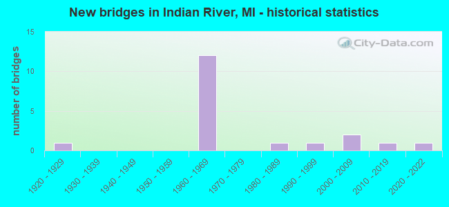
- New bridges - historical statistics
- 11920-1929
- 121960-1969
- 11980-1989
- 11990-1999
- 22000-2009
- 12010-2019
- 12020-2022


- Bridge Condition - Deck
- 8.3%Excellent
- 16.7%Very good
- 33.3%Good
- 25.0%Satisfactory
- 16.7%Fair

- Bridge Condition - Superstructure
- 33.3%Very good
- 41.7%Good
- 25.0%Fair

- Bridge Condition - Substructure
- 33.3%Very good
- 25.0%Good
- 25.0%Satisfactory
- 16.7%Fair

- Bridge Condition - Channel
- 44.4%Very good
- 44.4%Good
- 11.1%Satisfactory
Find on map >> Show street view
Structure Number: 1487, Location: 0.8 MI W OF I-75 (Lat: 45.402325, Lng: -84.617953), Route carried "on" structure: State highway 68, Year Built: 1927, Year Reconstructed: 1992, Status: Open, Structure Length: 1.89m (6.20ft), Average Daily Traffic: 10,873 (year 2018), Truck Traffic: 2%, Average Future Daily Traffic: 11,025 (year 2038), Design Load: HS 25 or greater, Features Intersected: STURGEON RIVER
Minimum Vertical Clearance: 30.48m (100.00ft), Kilometerpoint: 1.139, Lanes on structure: 2, Base Highway Network: Yes (Inventory Route: 54, Subroute: 7), Owner: State Highway Agency, Approaching Roadway Width: 12.8m (42.0ft), Material/Design: Prestressed concrete, Design/Construction: Stringer/Multi-beam, Number Of Spans In Main Unit: 1, Length of Maximum Span: 18.9m (62.0ft), Curb-To-Curb Width: 13.4m (44.0ft), Out-to-Out Width: 14.3m (46.9ft)
Condition: Deck: Satisfactory, Superstructure: Good, Substructure: Satisfactory, Channel: Very good, Operating Rating: 66.7 metric tons, Method Used To Determine Operating Rating: Load Factor (LF) rating reported by rating factor (RF) method using MS18 loading, Inventory Rating: 39.9 metric tons, Method Used To Determine Inventory Rating: Load Factor (LF) rating reported by rating factor (RF) method using MS18 loading, Structural Evaluation: Equal to present minimum criteria, Deck Geometry: Equal to present minimum criteria, Waterway Adequacy: Better than present minimum criteria, Approach Roadway Alignment: Equal to present minimum criteria, Designated Inspection Frequency: Every 24 months, Inspection Date: June 2021, Deck Structure Type: Concrete Cast-file-Place, Wearing Surface/Protective System: Wearing Surface: Epoxy Overlay, Deck Protection: Epoxy Coated Reinforcing
Find on map >> Show street view
Structure Number: 1491, Location: 2.2 MI N OF TOPINABEE (Lat: 45.507519, Lng: -84.564011), Route carried "on" structure: State highway 27, Year Built: 2004, Status: Open, Structure Length: 1.71m (5.61ft), Average Daily Traffic: 3,024 (year 2007), Truck Traffic: 12%, Average Future Daily Traffic: 4,010 (year 2018), Design Load: HS 25 or greater, Features Intersected: MULLETT CREEK
Minimum Vertical Clearance: 30.48m (100.00ft), Kilometerpoint: 8.422, Lanes on structure: 2, Base Highway Network: Yes (Inventory Route: 55, Subroute: 1), Owner: State Highway Agency, Approaching Roadway Width: 13.4m (44.0ft), Material/Design: Prestressed concrete, Design/Construction: Box Beam or Girders - Single/Spread, Number Of Spans In Main Unit: 1, Length of Maximum Span: 15.8m (51.8ft), Curb-To-Curb Width: 13.4m (44.0ft), Out-to-Out Width: 14.4m (47.2ft)
Condition: Deck: Good, Superstructure: Very good, Substructure: Very good, Channel: Very good, Operating Rating: 76.9 metric tons, Method Used To Determine Operating Rating: Load Factor (LF), Inventory Rating: 45.2 metric tons, Method Used To Determine Inventory Rating: Load Factor (LF), Structural Evaluation: Equal to present desirable criteria, Deck Geometry: Better than present minimum criteria, Waterway Adequacy: Equal to present minimum criteria, Approach Roadway Alignment: Somewhat better than minimum adequacy, Designated Inspection Frequency: Every 24 months, Inspection Date: June 2021, Deck Structure Type: Concrete Cast-file-Place, Wearing Surface/Protective System: Wearing Surface: Epoxy Overlay, Deck Protection: Epoxy Coated Reinforcing
Find on map >> Show street view
Structure Number: 1502, Location: 1.4 MI N OF M-68 (Lat: 45.422233, Lng: -84.602611), Route carried "on" structure: Interstate 75, Year Built: 1962, Status: Open, Structure Length: 5.48m (17.98ft), Average Daily Traffic: 4,474 (year 2007), Truck Traffic: 11%, Average Future Daily Traffic: 5,599 (year 2018), Design Load: HS 20, Features Intersected: INDIAN RIVER
Minimum Vertical Clearance: 30.48m (100.00ft), Kilometerpoint: 26.648, Lanes on structure: 2, Base Highway Network: Yes (Inventory Route: 55, Subroute: 6), Owner: State Highway Agency, Approaching Roadway Width: 13.7m (44.9ft), Skew: 3 degrees, Navigation Control: Yes ( Vertical Clearance: 0.3m (1.0ft), Horizontal Clearance: 16.1m (52.8ft)), Material/Design: Steel, Design/Construction: Stringer/Multi-beam, Number Of Spans In Main Unit: 3, Length of Maximum Span: 21.3m (69.9ft), Curb-To-Curb Width: 12.8m (42.0ft), Out-to-Out Width: 14.3m (46.9ft)
Condition: Deck: Satisfactory, Superstructure: Fair, Substructure: Good, Channel: Good, Operating Rating: 68.4 metric tons, Method Used To Determine Operating Rating: Load Factor (LF) rating reported by rating factor (RF) method using MS18 loading, Inventory Rating: 40.8 metric tons, Method Used To Determine Inventory Rating: Load Factor (LF) rating reported by rating factor (RF) method using MS18 loading, Structural Evaluation: Somewhat better than minimum adequacy, Deck Geometry: Equal to present desirable criteria, Waterway Adequacy: Superior to present desirable criteria, Approach Roadway Alignment: Equal to present minimum criteria, Designated Inspection Frequency: Every 11 months, Inspection Date: June 2021, Deck Structure Type: Concrete Cast-file-Place, Wearing Surface/Protective System: Wearing Surface: Epoxy Overlay
Find on map >> Show street view
Structure Number: 1503, Location: 1.4 MI N OF M-68 (Lat: 45.422042, Lng: -84.602861), Route carried "on" structure: Interstate 75, Year Built: 1962, Status: Open, Structure Length: 5.48m (17.98ft), Average Daily Traffic: 4,474 (year 2007), Truck Traffic: 11%, Average Future Daily Traffic: 5,599 (year 2018), Design Load: HS 20, Features Intersected: INDIAN RIVER
Minimum Vertical Clearance: 30.48m (100.00ft), Kilometerpoint: 26.742, Lanes on structure: 2, Base Highway Network: Yes (Inventory Route: 55, Subroute: 7), Owner: State Highway Agency, Approaching Roadway Width: 13.7m (44.9ft), Skew: 3 degrees, Navigation Control: Yes ( Vertical Clearance: 0.3m (1.0ft), Horizontal Clearance: 16.1m (52.8ft)), Material/Design: Steel, Design/Construction: Stringer/Multi-beam, Number Of Spans In Main Unit: 3, Length of Maximum Span: 21.3m (69.9ft), Curb-To-Curb Width: 12.8m (42.0ft), Out-to-Out Width: 14.3m (46.9ft)
Condition: Deck: Fair, Superstructure: Fair, Substructure: Good, Channel: Good, Operating Rating: 66.7 metric tons, Method Used To Determine Operating Rating: Load Factor (LF) rating reported by rating factor (RF) method using MS18 loading, Inventory Rating: 40.2 metric tons, Method Used To Determine Inventory Rating: Load Factor (LF) rating reported by rating factor (RF) method using MS18 loading, Structural Evaluation: Somewhat better than minimum adequacy, Deck Geometry: Equal to present desirable criteria, Waterway Adequacy: Superior to present desirable criteria, Approach Roadway Alignment: Equal to present minimum criteria, Designated Inspection Frequency: Every 24 months, Inspection Date: June 2021, Deck Structure Type: Concrete Cast-file-Place, Wearing Surface/Protective System: Wearing Surface: Epoxy Overlay
Find on map >> Show street view
Structure Number: 1505, Location: 1.9 MI S OF M-27 (Lat: 45.431650, Lng: -84.606036), Route carried "on" structure: Interstate 75, Year Built: 1962, Status: Open, Structure Length: 5.76m (18.90ft), Average Daily Traffic: 4,474 (year 2007), Truck Traffic: 11%, Average Future Daily Traffic: 5,599 (year 2018), Design Load: HS 20+Mod, Features Intersected: D&M RR (ABN)
Minimum Vertical Clearance: 30.48m (100.00ft), Kilometerpoint: 27.703, Lanes on structure: 2, Base Highway Network: Yes (Inventory Route: 55, Subroute: 6), Owner: State Highway Agency, Approaching Roadway Width: 13.7m (44.9ft), Skew: 4 degrees, Material/Design: Steel, Design/Construction: Stringer/Multi-beam, Number Of Spans In Main Unit: 3, Length of Maximum Span: 19.2m (63.0ft), Curb-To-Curb Width: 12.8m (42.0ft), Out-to-Out Width: 14.3m (46.9ft)
Condition: Deck: Good, Superstructure: Fair, Substructure: Fair, Operating Rating: 57.7 metric tons, Method Used To Determine Operating Rating: Load Factor (LF) rating reported by rating factor (RF) method using MS18 loading, Inventory Rating: 34.7 metric tons, Method Used To Determine Inventory Rating: Load Factor (LF) rating reported by rating factor (RF) method using MS18 loading, Structural Evaluation: Somewhat better than minimum adequacy, Deck Geometry: Equal to present desirable criteria, Approach Roadway Alignment: Somewhat better than minimum adequacy, Designated Inspection Frequency: Every 24 months, Inspection Date: April 2021, Bridge Improvement Cost: $130,000, Deck Structure Type: Concrete Cast-file-Place, Wearing Surface/Protective System: Wearing Surface: Epoxy Overlay
Find on map >> Show street view
Structure Number: 151, Location: @ M-27 (Lat: 45.446311, Lng: -84.608503), Route carried "on" structure: Interstate 75, Year Built: 1962, Status: Open, Structure Length: 6.99m (22.93ft), Average Daily Traffic: 7,777 (year 2018), Truck Traffic: 6%, Average Future Daily Traffic: 8,944 (year 2038), Design Load: HS 20+Mod, Features Intersected: M-27
Minimum Vertical Clearance: 30.48m (100.00ft), Kilometerpoint: 29.479, Lanes on structure: 2, Lanes under structure: 2, Base Highway Network: Yes (Inventory Route: 55, Subroute: 7), Owner: State Highway Agency, Approaching Roadway Width: 9.5m (31.2ft), Skew: 5 degrees, Material/Design: Steel, Design/Construction: Stringer/Multi-beam, Number Of Spans In Main Unit: 3, Length of Maximum Span: 28.5m (93.5ft), Curb-To-Curb Width: 9.8m (32.2ft), Out-to-Out Width: 10.8m (35.4ft)
Condition: Deck: Good, Superstructure: Good, Substructure: Satisfactory, Operating Rating: 70.3 metric tons, Method Used To Determine Operating Rating: Load Factor (LF) rating reported by rating factor (RF) method using MS18 loading, Inventory Rating: 42.1 metric tons, Method Used To Determine Inventory Rating: Load Factor (LF) rating reported by rating factor (RF) method using MS18 loading, Structural Evaluation: Equal to present minimum criteria, Deck Geometry: Meets minimum limits, Underclear: Somewhat better than minimum adequacy, Approach Roadway Alignment: Equal to present minimum criteria, Designated Inspection Frequency: Every 24 months, Inspection Date: April 2021, Deck Structure Type: Concrete Cast-file-Place, Wearing Surface/Protective System: Wearing Surface: Epoxy Overlay, Deck Protection: Epoxy Coated Reinforcing
Find on map >> Show street view
Structure Number: 1513, Location: 4.3 MI N OF M-27 (Lat: 45.520167, Lng: -84.615564), Route carried "on" structure: County highway 1656, Year Built: 1960, Status: Open, Structure Length: 6.98m (22.90ft), Average Daily Traffic: 220 (year 1997), Truck Traffic: 3%, Average Future Daily Traffic: 500 (year 2007), Design Load: H 15, Features Intersected: I-75, Facility Carried by Structure: MULLET-BURT RD
Minimum Vertical Clearance: 30.48m (100.00ft), Kilometerpoint: 2.796, Lanes on structure: 2, Lanes under structure: 4, Owner: State Highway Agency, Approaching Roadway Width: 10.9m (35.8ft), Material/Design: Concrete continuous, Design/Construction: Tee Beam, Number Of Spans In Main Unit: 4, Length of Maximum Span: 21.6m (70.9ft), Curb or Sidewalk Widths: Left: 0.7m (2.3ft), Right: 0.7m (2.3ft), Curb-To-Curb Width: 7.3m (24.0ft), Out-to-Out Width: 9.5m (31.2ft)
Condition: Deck: Satisfactory, Superstructure: Good, Substructure: Satisfactory, Operating Rating: 55.1 metric tons, Method Used To Determine Operating Rating: Load Factor (LF) rating reported by rating factor (RF) method using MS18 loading, Inventory Rating: 33.0 metric tons, Method Used To Determine Inventory Rating: Load Factor (LF) rating reported by rating factor (RF) method using MS18 loading, Structural Evaluation: Equal to present minimum criteria, Deck Geometry: Somewhat better than minimum adequacy, Underclear: Meets minimum limits, Approach Roadway Alignment: Somewhat better than minimum adequacy, Designated Inspection Frequency: Every 24 months, Inspection Date: April 2021, Deck Structure Type: Concrete Cast-file-Place, Wearing Surface/Protective System: Wearing Surface: Epoxy Overlay
Find on map >> Show street view
Structure Number: 153, Location: SEC 9 T35N R2W (Lat: 45.441014, Lng: -84.550383), Route carried "on" structure: County highway 1640, Year Built: 2009, Status: Open, Structure Length: 1.83m (6.00ft), Average Daily Traffic: 1,239 (year 2009), Truck Traffic: 3%, Average Future Daily Traffic: 1,841 (year 2029), Features Intersected: PIGEON RIVER, Facility Carried by Structure: COXEY ROAD
Minimum Vertical Clearance: 30.48m (100.00ft), Kilometerpoint: 0.420, Lanes on structure: 2, Owner: County Highway Agency, Approaching Roadway Width: 11.5m (37.7ft), Material/Design: Prestressed concrete, Design/Construction: Box Beam or Girders - Multiple, Number Of Spans In Main Unit: 1, Length of Maximum Span: 17.7m (58.1ft), Curb-To-Curb Width: 11.5m (37.7ft), Out-to-Out Width: 12.6m (41.3ft)
Condition: Deck: Very good, Superstructure: Very good, Substructure: Very good, Channel: Very good, Operating Rating: 95.3 metric tons, Method Used To Determine Operating Rating: Load and Resistance Factor Rating (LRFR) rating reported by rating factor(RF) method using HL-93 loadings, Inventory Rating: 73.5 metric tons, Method Used To Determine Inventory Rating: Load and Resistance Factor Rating (LRFR) rating reported by rating factor(RF) method using HL-93 loadings, Structural Evaluation: Equal to present desirable criteria, Deck Geometry: Equal to present minimum criteria, Waterway Adequacy: Superior to present desirable criteria, Approach Roadway Alignment: Equal to present desirable criteria, Designated Inspection Frequency: Every 24 months, Inspection Date: July 2021, Deck Structure Type: Concrete Cast-file-Place, Wearing Surface/Protective System: Wearing Surface: Monolithic Concrete, Deck Protection: Epoxy Coated Reinforcing
Find on map >> Show street view
Structure Number: 1533, Location: SEC 24 T35N R3W (Lat: 45.413308, Lng: -84.611456), Route carried "on" structure: County highway 1625, Year Built: 2012, Status: Open, Structure Length: 3.96m (12.99ft), Average Daily Traffic: 7,047 (year 2011), Average Future Daily Traffic: 9,491 (year 2031), Design Load: HL 93, Features Intersected: INDIAN RIVER, Facility Carried by Structure: STRAITS HWY(OLD 27
Minimum Vertical Clearance: 30+ m (98+ ft), Kilometerpoint: 1.059, Lanes on structure: 2, Base Highway Network: Yes (Inventory Route: 54, Subroute: 7), Owner: County Highway Agency, Approaching Roadway Width: 11.7m (38.4ft), Navigation Control: Yes ( Vertical Clearance: 0.3m (1.0ft), Horizontal Clearance: 10.9m (35.8ft)), Material/Design: Prestressed concrete, Design/Construction: Box Beam or Girders - Multiple, Number Of Spans In Main Unit: 1, Length of Maximum Span: 38.9m (127.6ft), Curb or Sidewalk Widths: Left: 1.8m (5.9ft), Right: 0.0m, Curb-To-Curb Width: 12.2m (40.0ft), Out-to-Out Width: 15.1m (49.5ft)
Condition: Deck: Very good, Superstructure: Very good, Substructure: Very good, Channel: Very good, Operating Rating: 50.9 metric tons, Method Used To Determine Operating Rating: Load and Resistance Factor Rating (LRFR) rating reported by rating factor(RF) method using HL-93 loadings, Inventory Rating: 34.3 metric tons, Method Used To Determine Inventory Rating: Load and Resistance Factor Rating (LRFR) rating reported by rating factor(RF) method using HL-93 loadings, Structural Evaluation: Equal to present desirable criteria, Deck Geometry: Somewhat better than minimum adequacy, Waterway Adequacy: Equal to present desirable criteria, Approach Roadway Alignment: Equal to present desirable criteria, Designated Inspection Frequency: Every 24 months, Inspection Date: July 2021, Deck Structure Type: Concrete Cast-file-Place, Wearing Surface/Protective System: Wearing Surface: Monolithic Concrete, Deck Protection: Epoxy Coated Reinforcing
Find on map >> Show street view
Structure Number: 1547, Location: SEC.13,T34N,R3W (Lat: 45.338631, Lng: -84.627375), Route carried "on" structure: County highway , Year Built: 1992, Status: Open, Structure Length: 4.05m (13.29ft), Average Daily Traffic: 270 (year 2005), Average Future Daily Traffic: 300 (year 2025), Design Load: HS 20+Mod, Features Intersected: STURGEON RIVER, Facility Carried by Structure: WHITE RD (S.END)
Minimum Vertical Clearance: 30.48m (100.00ft), Kilometerpoint: 0.229, Lanes on structure: 2, Owner: County Highway Agency, Approaching Roadway Width: 9.8m (32.2ft), Material/Design: Prestressed concrete, Design/Construction: Box Beam or Girders - Multiple, Number Of Spans In Main Unit: 3, Length of Maximum Span: 14.6m (47.9ft), Curb-To-Curb Width: 9.1m (29.9ft), Out-to-Out Width: 9.5m (31.2ft)
Condition: Deck: Fair, Superstructure: Good, Substructure: Good, Channel: Good, Operating Rating: 47.0 metric tons, Method Used To Determine Operating Rating: Load and Resistance Factor Rating (LRFR) rating reported by rating factor(RF) method using HL-93 loadings, Inventory Rating: 27.9 metric tons, Method Used To Determine Inventory Rating: Load and Resistance Factor Rating (LRFR) rating reported by rating factor(RF) method using HL-93 loadings, Structural Evaluation: Better than present minimum criteria, Deck Geometry: Equal to present minimum criteria, Waterway Adequacy: Equal to present desirable criteria, Approach Roadway Alignment: Better than present minimum criteria, Designated Inspection Frequency: Every 24 months, Inspection Date: July 2021, Deck Structure Type: Concrete Cast-file-Place, Wearing Surface/Protective System: Wearing Surface: Monolithic Concrete
Find on map >> Show street view
Structure Number: 1548, Location: SEC.1,T34N,R3W (Lat: 45.372036, Lng: -84.624292), Route carried "on" structure: County highway , Year Built: 1985, Status: Open, Structure Length: 1.46m (4.79ft), Average Daily Traffic: 380 (year 2005), Average Future Daily Traffic: 700 (year 2025), Design Load: HS 20+Mod, Features Intersected: STURGEON RIVER, Facility Carried by Structure: WHITE RD (N. END)
Minimum Vertical Clearance: 30.48m (100.00ft), Kilometerpoint: 4.637, Lanes on structure: 2, Owner: County Highway Agency, Approaching Roadway Width: 9.1m (29.9ft), Material/Design: Prestressed concrete, Design/Construction: Box Beam or Girders - Multiple, Number Of Spans In Main Unit: 1, Length of Maximum Span: 14.6m (47.9ft), Curb-To-Curb Width: 9.4m (30.8ft), Out-to-Out Width: 9.4m (30.8ft)
Condition: Deck: Good, Superstructure: Good, Substructure: Fair, Channel: Good, Operating Rating: 45.4 metric tons, Method Used To Determine Operating Rating: Load and Resistance Factor Rating (LRFR) rating reported by rating factor(RF) method using HL-93 loadings, Inventory Rating: 35.0 metric tons, Method Used To Determine Inventory Rating: Load and Resistance Factor Rating (LRFR) rating reported by rating factor(RF) method using HL-93 loadings, Structural Evaluation: Somewhat better than minimum adequacy, Deck Geometry: Equal to present minimum criteria, Waterway Adequacy: Better than present minimum criteria, Approach Roadway Alignment: Better than present minimum criteria, Designated Inspection Frequency: Every 24 months, Inspection Date: July 2021, Deck Structure Type: Concrete Cast-file-Place, Wearing Surface/Protective System: Wearing Surface: Bituminous, Deck Protection: Epoxy Coated Reinforcing
Find on map >> Show street view
Structure Number: 14489, Location: 0.63 MI S OF PARKE RD (Lat: 45.388900, Lng: -84.730000), Route carried "on" structure: County highway 2497, Year Built: 2021, Status: Open, Structure Length: 0.85m (2.79ft), Average Daily Traffic: 700 (year 2019), Truck Traffic: 5%, Average Future Daily Traffic: 850 (year 2039), Design Load: Greater than HL93, Features Intersected: CEDAR CREEK, Facility Carried by Structure: BANWELL RD
Minimum Vertical Clearance: 30.48m (100.00ft), Kilometerpoint: 1.000, Lanes on structure: 2, Owner: County Highway Agency, Approaching Roadway Width: 9.1m (29.9ft), Skew: 1 degrees, Material/Design: Wood or Timber, Design/Construction: Slab, Number Of Spans In Main Unit: 1, Length of Maximum Span: 7.9m (25.9ft), Curb-To-Curb Width: 9.1m (29.9ft), Out-to-Out Width: 9.8m (32.2ft)
Condition: Deck: Excellent, Superstructure: Very good, Substructure: Very good, Channel: Satisfactory, Operating Rating: 82.6 metric tons, Method Used To Determine Operating Rating: Load and Resistance Factor Rating (LRFR) rating reported by rating factor(RF) method using HL-93 loadings, Inventory Rating: 63.8 metric tons, Method Used To Determine Inventory Rating: Load and Resistance Factor Rating (LRFR) rating reported by rating factor(RF) method using HL-93 loadings, Structural Evaluation: Equal to present desirable criteria, Deck Geometry: Equal to present minimum criteria, Waterway Adequacy: Equal to present desirable criteria, Approach Roadway Alignment: Equal to present desirable criteria, Designated Inspection Frequency: Every 24 months, Inspection Date: September 2021, Deck Structure Type: Wood or Timber, Wearing Surface/Protective System: Wearing Surface: Bituminous
Find on map >> Show street view
Structure Number: 1507, Location: @ M-68 (Lat: 45.401986, Lng: -84.607392), Route carried "under" structure: Interstate 75, Year Built: 1962, Structure Length: 0. m, Average Daily Traffic: 4,809 (year 2007), Truck Traffic: 11%, Features Intersected: I-75 SB, Facility Carried by Structure: M-68
Minimum Vertical Clearance: 30+ m (98+ ft), Kilometerpoint: 24.416, Lanes on structure: 2, Lanes under structure: 2, Material/Design: Steel, Design/Construction: Stringer/Multi-beam, Length of Maximum Span: 18.6m (61.0ft)
Find on map >> Show street view
Structure Number: 1508, Location: @ M-68 (Lat: 45.401778, Lng: -84.606589), Route carried "under" structure: Interstate 75, Year Built: 1962, Structure Length: 0. m, Average Daily Traffic: 4,809 (year 2007), Truck Traffic: 11%, Features Intersected: I-75 NB, Facility Carried by Structure: M-68
Minimum Vertical Clearance: 5.03m (16.50ft), Kilometerpoint: 24.289, Lanes on structure: 2, Lanes under structure: 2, Material/Design: Steel, Design/Construction: Stringer/Multi-beam, Length of Maximum Span: 21.9m (71.9ft)
Find on map >> Show street view
Structure Number: 1509, Location: 0.6 MI N OF M-68 (Lat: 45.411194, Lng: -84.604814), Route carried "under" structure: Interstate 75, Year Built: 1962, Structure Length: 0. m, Average Daily Traffic: 8,948 (year 2007), Truck Traffic: 11%, Features Intersected: I-75, Facility Carried by Structure: ONAWAY RD/OLD M-68
Minimum Vertical Clearance: 4.93m (16.17ft), Kilometerpoint: 25.354, Lanes on structure: 2, Lanes under structure: 4, Material/Design: Steel, Design/Construction: Stringer/Multi-beam, Length of Maximum Span: 18.9m (62.0ft)
Find on map >> Show street view
Structure Number: 151, Location: @ M-27 (Lat: 45.446311, Lng: -84.608503), Route carried "under" structure: State highway 27, Year Built: 1962, Structure Length: 0. m, Average Daily Traffic: 4,920 (year 2007), Truck Traffic: 8%, Features Intersected: M-27, Facility Carried by Structure: I-75 SB
Minimum Vertical Clearance: 4.52m (14.83ft), Kilometerpoint: 0.266, Lanes on structure: 2, Lanes under structure: 2, Material/Design: Steel, Design/Construction: Stringer/Multi-beam, Length of Maximum Span: 28.5m (93.5ft)
Find on map >> Show street view
Structure Number: 1511, Location: @ M-27 (Lat: 45.450536, Lng: -84.610539), Route carried "under" structure: State highway 27, Year Built: 1962, Structure Length: 0. m, Average Daily Traffic: 4,920 (year 2007), Truck Traffic: 8%, Features Intersected: M-27, Facility Carried by Structure: I-75 NB
Minimum Vertical Clearance: 4.72m (15.49ft), Kilometerpoint: 0.771, Lanes on structure: 2, Lanes under structure: 2, Material/Design: Steel, Design/Construction: Stringer/Multi-beam, Length of Maximum Span: 28.5m (93.5ft)
Find on map >> Show street view
Structure Number: 1512, Location: 2.8 MI N OF M-27 (Lat: 45.497942, Lng: -84.615544), Route carried "under" structure: Interstate 75, Year Built: 1960, Structure Length: 0. m, Average Daily Traffic: 7,974 (year 2007), Truck Traffic: 12%, Features Intersected: I-75, Facility Carried by Structure: TOPINABEE RD
Minimum Vertical Clearance: 6.43m (21.10ft), Kilometerpoint: 35.252, Lanes on structure: 2, Lanes under structure: 4, Material/Design: Concrete continuous, Design/Construction: Tee Beam, Length of Maximum Span: 36.2m (118.8ft)
Find on map >> Show street view
Structure Number: 1513, Location: 4.3 MI N OF M-27 (Lat: 45.520167, Lng: -84.615564), Route carried "under" structure: Interstate 75, Year Built: 1960, Structure Length: 0. m, Average Daily Traffic: 7,974 (year 2007), Truck Traffic: 12%, Features Intersected: I-75, Facility Carried by Structure: MULLET-BURT RD
Minimum Vertical Clearance: 5.44m (17.85ft), Kilometerpoint: 37.721, Lanes on structure: 2, Lanes under structure: 4, Material/Design: Concrete continuous, Design/Construction: Tee Beam, Length of Maximum Span: 21.6m (70.9ft)