Bridge Statistics for Inkom, Idaho (ID)
Condition, Traffic, Stress, Structural Evaluation, Project Costs
- National Bridge Inventory (NBI) Statistics
- 23Number of bridges
- 220ft / 67.0mTotal length
- $14,757,000Total costs
- 107,740Total average daily traffic
- 21,352Total average daily truck traffic
- National Bridge Inventory (NBI) Registered Bridges for Inkom
- No street view available for this location
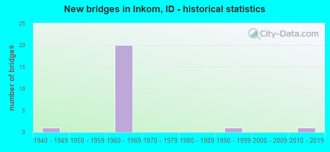
- New bridges - historical statistics
- 11940-1949
- 201960-1969
- 11990-1999
- 12010-2019


- Bridge Condition - Deck
- 6.7%Very good
- 40.0%Good
- 40.0%Satisfactory
- 13.3%Fair

- Bridge Condition - Superstructure
- 6.7%Very good
- 13.3%Good
- 33.3%Satisfactory
- 26.7%Fair
- 20.0%Poor

- Bridge Condition - Substructure
- 6.7%Very good
- 13.3%Good
- 46.7%Satisfactory
- 20.0%Fair
- 13.3%Poor

- Bridge Condition - Channel
- 57.1%Very good
- 28.6%Good
- 14.3%Fair
Find on map >> Show street view
Structure Number: 11135, Location: 1.6 S. INKOM (Lat: 42.782139, Lng: -112.230583), Route carried "on" structure: Interstate 15, Year Built: 1963, Status: Open, Structure Length: 4.60m (15.09ft), Average Daily Traffic: 8,000 (year 2019), Truck Traffic: 21%, Average Future Daily Traffic: 12,000 (year 2039), Design Load: HS 20, Features Intersected: PORTNEUF RIVER
Minimum Vertical Clearance: 30+ m (98+ ft), Kilometerpoint: 89.550, Lanes on structure: 2, Base Highway Network: Yes, Owner: State Highway Agency, Approaching Roadway Width: 11.6m (38.1ft), Material/Design: Prestressed concrete, Design/Construction: Stringer/Multi-beam, Number Of Spans In Main Unit: 3, Length of Maximum Span: 14.9m (48.9ft), Curb-To-Curb Width: 11.6m (38.1ft), Out-to-Out Width: 12.2m (40.0ft)
Condition: Deck: Good, Superstructure: Fair, Substructure: Satisfactory, Channel: Good, Operating Rating: 48.1 metric tons, Method Used To Determine Operating Rating: Load Factor (LF), Inventory Rating: 29.0 metric tons, Method Used To Determine Inventory Rating: Load Factor (LF), Structural Evaluation: Somewhat better than minimum adequacy, Deck Geometry: Equal to present minimum criteria, Waterway Adequacy: Superior to present desirable criteria, Approach Roadway Alignment: Equal to present desirable criteria, Designated Inspection Frequency: Every 24 months, Inspection Date: June 2021, Deck Structure Type: Concrete Cast-file-Place, Wearing Surface/Protective System: Wearing Surface: Latex Concrete
Find on map >> Show street view
Structure Number: 1114, Location: 1.6 S. INKOM (Lat: 42.782500, Lng: -112.230944), Route carried "on" structure: Interstate 15, Year Built: 1963, Status: Open, Structure Length: 4.60m (15.09ft), Average Daily Traffic: 8,000 (year 2019), Truck Traffic: 21%, Average Future Daily Traffic: 12,000 (year 2039), Design Load: HS 20, Features Intersected: PORTNEUF RIVER
Minimum Vertical Clearance: 30+ m (98+ ft), Kilometerpoint: 89.554, Lanes on structure: 2, Base Highway Network: Yes, Owner: State Highway Agency, Approaching Roadway Width: 11.6m (38.1ft), Material/Design: Prestressed concrete, Design/Construction: Stringer/Multi-beam, Number Of Spans In Main Unit: 3, Length of Maximum Span: 14.9m (48.9ft), Curb-To-Curb Width: 11.6m (38.1ft), Out-to-Out Width: 12.2m (40.0ft)
Condition: Deck: Good, Superstructure: Satisfactory, Substructure: Satisfactory, Channel: Good, Operating Rating: 48.1 metric tons, Method Used To Determine Operating Rating: Load Factor (LF), Inventory Rating: 29.0 metric tons, Method Used To Determine Inventory Rating: Load Factor (LF), Structural Evaluation: Equal to present minimum criteria, Deck Geometry: Equal to present minimum criteria, Waterway Adequacy: Equal to present desirable criteria, Approach Roadway Alignment: Equal to present desirable criteria, Designated Inspection Frequency: Every 24 months, Inspection Date: June 2021, Deck Structure Type: Concrete Cast-file-Place, Wearing Surface/Protective System: Wearing Surface: Latex Concrete
Find on map >> Show street view
Structure Number: 11145, Location: 1.3 S. INKOM (Lat: 42.786111, Lng: -112.233167), Route carried "on" structure: Interstate 15, Year Built: 1963, Status: Open, Structure Length: 11.86m (38.91ft), Average Daily Traffic: 8,000 (year 2019), Truck Traffic: 21%, Average Future Daily Traffic: 12,000 (year 2039), Design Load: HS 20, Features Intersected: STC 1758;UPRR;INKOM OP
Minimum Vertical Clearance: 30+ m (98+ ft), Kilometerpoint: 90.041, Lanes on structure: 2, Lanes under structure: 2, Base Highway Network: Yes, Owner: State Highway Agency, Approaching Roadway Width: 11.6m (38.1ft), Skew: 5 degrees, Material/Design: Prestressed concrete, Design/Construction: Stringer/Multi-beam, Number Of Spans In Main Unit: 6, Length of Maximum Span: 26.5m (86.9ft), Curb-To-Curb Width: 9.2m (30.2ft), Out-to-Out Width: 10.6m (34.8ft)
Condition: Deck: Satisfactory, Superstructure: Fair, Substructure: Satisfactory, Operating Rating: 57.2 metric tons, Method Used To Determine Operating Rating: Load Factor (LF), Inventory Rating: 31.8 metric tons, Method Used To Determine Inventory Rating: Load Factor (LF), Structural Evaluation: Somewhat better than minimum adequacy, Deck Geometry: Meets minimum limits, Underclear: High priority of replacement, Approach Roadway Alignment: Equal to present desirable criteria, Length Of Structure Improvement: 13.05m (42.81ft), Designated Inspection Frequency: Every 24 months, Inspection Date: June 2021, Bridge Improvement Cost: $2,966,000, Roadway Improvement Cost: $297,000, Total Project Cost: $4,449,000 ( Estimate for 2019), Deck Structure Type: Concrete Cast-file-Place, Wearing Surface/Protective System: Wearing Surface: Bituminous, Membrane: Preformed Fabric
Find on map >> Show street view
Structure Number: 1115, Location: 1.3 S. INKOM (Lat: 42.787139, Lng: -112.234306), Route carried "on" structure: Interstate 15, Year Built: 1963, Status: Open, Structure Length: 12.16m (39.90ft), Average Daily Traffic: 8,000 (year 2019), Truck Traffic: 21%, Average Future Daily Traffic: 12,000 (year 2039), Design Load: HS 20, Features Intersected: STC 1758;UPRR;INKOM OP
Minimum Vertical Clearance: 30+ m (98+ ft), Kilometerpoint: 90.043, Lanes on structure: 2, Lanes under structure: 2, Base Highway Network: Yes, Owner: State Highway Agency, Approaching Roadway Width: 11.6m (38.1ft), Skew: 5 degrees, Material/Design: Prestressed concrete, Design/Construction: Stringer/Multi-beam, Number Of Spans In Main Unit: 6, Length of Maximum Span: 26.5m (86.9ft), Curb-To-Curb Width: 9.1m (29.9ft), Out-to-Out Width: 10.6m (34.8ft)
Condition: Deck: Satisfactory, Superstructure: Fair, Substructure: Fair, Operating Rating: 58.1 metric tons, Method Used To Determine Operating Rating: Load Factor (LF), Inventory Rating: 32.7 metric tons, Method Used To Determine Inventory Rating: Load Factor (LF), Structural Evaluation: Somewhat better than minimum adequacy, Deck Geometry: Meets minimum limits, Underclear: High priority of replacement, Approach Roadway Alignment: Equal to present desirable criteria, Length Of Structure Improvement: 13.05m (42.81ft), Designated Inspection Frequency: Every 24 months, Inspection Date: June 2021, Bridge Improvement Cost: $2,966,000, Roadway Improvement Cost: $297,000, Total Project Cost: $4,449,000 ( Estimate for 2019), Deck Structure Type: Concrete Cast-file-Place, Wearing Surface/Protective System: Wearing Surface: Bituminous, Membrane: Preformed Fabric
Find on map >> Show street view
Structure Number: 11155, Location: 0.5 E. INKOM (Lat: 42.793222, Lng: -112.243278), Route carried "on" structure: Ramp Interstate 15, Year Built: 1962, Status: Open, Structure Length: 3.47m (11.38ft), Average Daily Traffic: 8,000 (year 2019), Truck Traffic: 21%, Average Future Daily Traffic: 12,000 (year 2039), Design Load: HS 20, Features Intersected: I 15B;S.INKOM IC
Minimum Vertical Clearance: 30+ m (98+ ft), Kilometerpoint: 91.193, Lanes on structure: 2, Lanes under structure: 1, Base Highway Network: Yes, Owner: State Highway Agency, Approaching Roadway Width: 11.6m (38.1ft), Skew: 3 degrees, Material/Design: Concrete, Design/Construction: Stringer/Multi-beam, Number Of Spans In Main Unit: 3, Length of Maximum Span: 11.3m (37.1ft), Curb-To-Curb Width: 11.6m (38.1ft), Out-to-Out Width: 12.2m (40.0ft)
Condition: Deck: Good, Superstructure: Good, Substructure: Good, Operating Rating: 52.6 metric tons, Method Used To Determine Operating Rating: Load Factor (LF), Inventory Rating: 31.8 metric tons, Method Used To Determine Inventory Rating: Load Factor (LF), Structural Evaluation: Better than present minimum criteria, Deck Geometry: Superior to present desirable criteria, Underclear: High priority of corrective action, Approach Roadway Alignment: Equal to present desirable criteria, Designated Inspection Frequency: Every 48 months, Inspection Date: June 2018, Deck Structure Type: Concrete Cast-file-Place, Wearing Surface/Protective System: Wearing Surface: Latex Concrete
Find on map >> Show street view
Structure Number: 1116, Location: 0.5 E. INKOM (Lat: 42.793347, Lng: -112.243864), Route carried "on" structure: Ramp Interstate 15, Year Built: 1962, Status: Open, Structure Length: 3.47m (11.38ft), Average Daily Traffic: 8,000 (year 2019), Truck Traffic: 21%, Average Future Daily Traffic: 12,000 (year 2039), Design Load: HS 20, Features Intersected: I 15B;S.INKOM IC
Minimum Vertical Clearance: 30+ m (98+ ft), Kilometerpoint: 91.195, Lanes on structure: 2, Lanes under structure: 1, Base Highway Network: Yes, Owner: State Highway Agency, Approaching Roadway Width: 11.6m (38.1ft), Skew: 3 degrees, Material/Design: Concrete, Design/Construction: Stringer/Multi-beam, Number Of Spans In Main Unit: 3, Length of Maximum Span: 11.3m (37.1ft), Curb-To-Curb Width: 11.6m (38.1ft), Out-to-Out Width: 12.2m (40.0ft)
Condition: Deck: Good, Superstructure: Good, Substructure: Good, Operating Rating: 52.6 metric tons, Method Used To Determine Operating Rating: Load Factor (LF), Inventory Rating: 31.8 metric tons, Method Used To Determine Inventory Rating: Load Factor (LF), Structural Evaluation: Better than present minimum criteria, Deck Geometry: Superior to present desirable criteria, Underclear: High priority of corrective action, Approach Roadway Alignment: Equal to present desirable criteria, Designated Inspection Frequency: Every 48 months, Inspection Date: June 2018, Deck Structure Type: Concrete Cast-file-Place, Wearing Surface/Protective System: Wearing Surface: Latex Concrete
Find on map >> Show street view
Structure Number: 11165, Location: 0.1 E. INKOM (Lat: 42.796833, Lng: -112.249444), Route carried "on" structure: Interstate 15, Year Built: 1963, Status: Open, Structure Length: 4.60m (15.09ft), Average Daily Traffic: 8,500 (year 2019), Truck Traffic: 21%, Average Future Daily Traffic: 12,750 (year 2039), Design Load: HS 20, Features Intersected: RAPID CREEK;INKOM
Minimum Vertical Clearance: 30+ m (98+ ft), Kilometerpoint: 91.821, Lanes on structure: 2, Base Highway Network: Yes, Owner: State Highway Agency, Approaching Roadway Width: 11.6m (38.1ft), Material/Design: Prestressed concrete, Design/Construction: Stringer/Multi-beam, Number Of Spans In Main Unit: 3, Length of Maximum Span: 14.9m (48.9ft), Curb-To-Curb Width: 11.6m (38.1ft), Out-to-Out Width: 12.2m (40.0ft)
Condition: Deck: Good, Superstructure: Satisfactory, Substructure: Satisfactory, Channel: Very good, Operating Rating: 50.8 metric tons, Method Used To Determine Operating Rating: Load Factor (LF), Inventory Rating: 29.9 metric tons, Method Used To Determine Inventory Rating: Load Factor (LF), Structural Evaluation: Equal to present minimum criteria, Deck Geometry: Equal to present minimum criteria, Waterway Adequacy: Equal to present desirable criteria, Approach Roadway Alignment: Equal to present desirable criteria, Designated Inspection Frequency: Every 48 months, Inspection Date: June 2021, Deck Structure Type: Concrete Cast-file-Place, Wearing Surface/Protective System: Wearing Surface: Latex Concrete
Find on map >> Show street view
Structure Number: 1117, Location: 0.1 E. INKOM (Lat: 42.796944, Lng: -112.250031), Route carried "on" structure: Interstate 15, Year Built: 1963, Status: Open, Structure Length: 4.60m (15.09ft), Average Daily Traffic: 8,500 (year 2019), Truck Traffic: 21%, Average Future Daily Traffic: 12,750 (year 2039), Design Load: HS 20, Features Intersected: RAPID CREEK;INKOM
Minimum Vertical Clearance: 30+ m (98+ ft), Kilometerpoint: 91.823, Lanes on structure: 2, Base Highway Network: Yes, Owner: State Highway Agency, Approaching Roadway Width: 11.6m (38.1ft), Material/Design: Prestressed concrete, Design/Construction: Stringer/Multi-beam, Number Of Spans In Main Unit: 3, Length of Maximum Span: 14.9m (48.9ft), Curb-To-Curb Width: 11.6m (38.1ft), Out-to-Out Width: 12.2m (40.0ft)
Condition: Deck: Good, Superstructure: Satisfactory, Substructure: Satisfactory, Channel: Very good, Operating Rating: 51.7 metric tons, Method Used To Determine Operating Rating: Load Factor (LF), Inventory Rating: 30.8 metric tons, Method Used To Determine Inventory Rating: Load Factor (LF), Structural Evaluation: Equal to present minimum criteria, Deck Geometry: Equal to present minimum criteria, Waterway Adequacy: Equal to present desirable criteria, Approach Roadway Alignment: Equal to present desirable criteria, Designated Inspection Frequency: Every 48 months, Inspection Date: June 2021, Deck Structure Type: Concrete Cast-file-Place, Wearing Surface/Protective System: Wearing Surface: Latex Concrete
Find on map >> Show street view
Structure Number: 11175, Location: IN INKOM;MAIN ST. (Lat: 42.797944, Lng: -112.251583), Route carried "on" structure: Interstate 15, Year Built: 1962, Status: Open, Structure Length: 3.78m (12.40ft), Average Daily Traffic: 8,500 (year 2019), Truck Traffic: 21%, Average Future Daily Traffic: 12,750 (year 2039), Design Load: HS 20, Features Intersected: MAIN STREET GS
Minimum Vertical Clearance: 30+ m (98+ ft), Kilometerpoint: 92.030, Lanes on structure: 2, Lanes under structure: 2, Base Highway Network: Yes, Owner: State Highway Agency, Approaching Roadway Width: 11.6m (38.1ft), Skew: 3 degrees, Material/Design: Concrete, Design/Construction: Stringer/Multi-beam, Number Of Spans In Main Unit: 3, Length of Maximum Span: 12.5m (41.0ft), Curb-To-Curb Width: 11.8m (38.7ft), Out-to-Out Width: 12.2m (40.0ft)
Condition: Deck: Fair, Superstructure: Poor, Substructure: Poor, Operating Rating: 58.1 metric tons, Method Used To Determine Operating Rating: Load Factor (LF), Inventory Rating: 34.5 metric tons, Method Used To Determine Inventory Rating: Load Factor (LF), Structural Evaluation: Meets minimum limits, Deck Geometry: Equal to present minimum criteria, Underclear: High priority of replacement, Approach Roadway Alignment: Equal to present desirable criteria, Length Of Structure Improvement: 4.88m (16.01ft), Designated Inspection Frequency: Every 12 months, Inspection Date: September 2021, Bridge Improvement Cost: $1,170,000, Roadway Improvement Cost: $117,000, Total Project Cost: $1,755,000 ( Estimate for 2018), Deck Structure Type: Concrete Cast-file-Place, Wearing Surface/Protective System: Wearing Surface: Bituminous, Membrane: Preformed Fabric
Find on map >> Show street view
Structure Number: 1118, Location: IN INKOM;MAIN ST. (Lat: 42.797972, Lng: -112.252250), Route carried "on" structure: Interstate 15, Year Built: 1962, Status: Open, Structure Length: 3.78m (12.40ft), Average Daily Traffic: 8,500 (year 2019), Truck Traffic: 21%, Average Future Daily Traffic: 12,750 (year 2039), Design Load: HS 20, Features Intersected: MAIN STREET GS
Minimum Vertical Clearance: 30+ m (98+ ft), Kilometerpoint: 92.032, Lanes on structure: 2, Lanes under structure: 2, Base Highway Network: Yes, Owner: State Highway Agency, Approaching Roadway Width: 11.6m (38.1ft), Skew: 3 degrees, Material/Design: Concrete, Design/Construction: Stringer/Multi-beam, Number Of Spans In Main Unit: 3, Length of Maximum Span: 12.5m (41.0ft), Curb-To-Curb Width: 11.7m (38.4ft), Out-to-Out Width: 12.2m (40.0ft)
Condition: Deck: Fair, Superstructure: Poor, Substructure: Poor, Operating Rating: 58.1 metric tons, Method Used To Determine Operating Rating: Load Factor (LF), Inventory Rating: 34.5 metric tons, Method Used To Determine Inventory Rating: Load Factor (LF), Structural Evaluation: Meets minimum limits, Deck Geometry: Equal to present minimum criteria, Underclear: High priority of replacement, Approach Roadway Alignment: Equal to present desirable criteria, Length Of Structure Improvement: 4.88m (16.01ft), Designated Inspection Frequency: Every 12 months, Inspection Date: September 2021, Bridge Improvement Cost: $1,170,000, Roadway Improvement Cost: $117,000, Total Project Cost: $1,755,000 ( Estimate for 2017), Deck Structure Type: Concrete Cast-file-Place, Wearing Surface/Protective System: Wearing Surface: Bituminous, Membrane: Preformed Fabric
Find on map >> Show street view
Structure Number: 11185, Location: 0.5 W. INKOM (Lat: 42.798897, Lng: -112.261492), Route carried "on" structure: Interstate 15, Year Built: 1962, Status: Open, Structure Length: 3.47m (11.38ft), Average Daily Traffic: 8,500 (year 2019), Truck Traffic: 21%, Average Future Daily Traffic: 12,750 (year 2039), Design Load: HS 20, Features Intersected: I 15B;W.INKOM IC
Minimum Vertical Clearance: 30+ m (98+ ft), Kilometerpoint: 92.833, Lanes on structure: 2, Lanes under structure: 2, Base Highway Network: Yes, Owner: State Highway Agency, Approaching Roadway Width: 11.6m (38.1ft), Material/Design: Concrete, Design/Construction: Stringer/Multi-beam, Number Of Spans In Main Unit: 3, Length of Maximum Span: 11.3m (37.1ft), Curb-To-Curb Width: 11.6m (38.1ft), Out-to-Out Width: 12.2m (40.0ft)
Condition: Deck: Satisfactory, Superstructure: Poor, Substructure: Fair, Operating Rating: 50.8 metric tons, Method Used To Determine Operating Rating: Load Factor (LF), Inventory Rating: 30.8 metric tons, Method Used To Determine Inventory Rating: Load Factor (LF), Structural Evaluation: Meets minimum limits, Deck Geometry: Equal to present minimum criteria, Underclear: High priority of replacement, Approach Roadway Alignment: Equal to present desirable criteria, Length Of Structure Improvement: 4.51m (14.80ft), Designated Inspection Frequency: Every 12 months, Inspection Date: September 2021, Bridge Improvement Cost: $1,026,000, Roadway Improvement Cost: $103,000, Total Project Cost: $1,539,000 ( Estimate for 2019), Deck Structure Type: Concrete Cast-file-Place, Wearing Surface/Protective System: Wearing Surface: Bituminous, Membrane: Preformed Fabric
Find on map >> Show street view
Structure Number: 1119, Location: 0.5 W. INKOM (Lat: 42.798758, Lng: -112.261933), Route carried "on" structure: Interstate 15, Year Built: 1962, Status: Open, Structure Length: 3.47m (11.38ft), Average Daily Traffic: 8,500 (year 2019), Truck Traffic: 21%, Average Future Daily Traffic: 12,750 (year 2039), Design Load: HS 20, Features Intersected: I 15B;W.INKOM IC
Minimum Vertical Clearance: 30+ m (98+ ft), Kilometerpoint: 92.835, Lanes on structure: 2, Lanes under structure: 2, Base Highway Network: Yes, Owner: State Highway Agency, Approaching Roadway Width: 11.6m (38.1ft), Material/Design: Concrete, Design/Construction: Stringer/Multi-beam, Number Of Spans In Main Unit: 3, Length of Maximum Span: 11.3m (37.1ft), Curb-To-Curb Width: 11.6m (38.1ft), Out-to-Out Width: 12.2m (40.0ft)
Condition: Deck: Satisfactory, Superstructure: Fair, Substructure: Fair, Operating Rating: 50.8 metric tons, Method Used To Determine Operating Rating: Load Factor (LF), Inventory Rating: 30.8 metric tons, Method Used To Determine Inventory Rating: Load Factor (LF), Structural Evaluation: Somewhat better than minimum adequacy, Deck Geometry: Equal to present minimum criteria, Underclear: High priority of corrective action, Approach Roadway Alignment: Equal to present desirable criteria, Designated Inspection Frequency: Every 24 months, Inspection Date: September 2021, Deck Structure Type: Concrete Cast-file-Place, Wearing Surface/Protective System: Wearing Surface: Bituminous, Membrane: Preformed Fabric
Find on map >> Show street view
Structure Number: 21908, Location: MAIN STREET (Lat: 42.794444, Lng: -112.252778), Route carried "on" structure: City street 1760, Year Built: 2015, Status: Open, Structure Length: 1.04m (3.41ft), Average Daily Traffic: 1,000 (year 2019), Truck Traffic: 4%, Average Future Daily Traffic: 1,500 (year 2039), Design Load: HL 93, Features Intersected: RAPID CREEK
Minimum Vertical Clearance: 30+ m (98+ ft), Kilometerpoint: 0.146, Lanes on structure: 2, Owner: City or Municipal Highway Agency, Approaching Roadway Width: 7.9m (25.9ft), Skew: 4 degrees, Material/Design: Concrete, Design/Construction: Frame, Number Of Spans In Main Unit: 1, Length of Maximum Span: 10.4m (34.1ft), Curb or Sidewalk Widths: Left: 1.5m (4.9ft), Right: 1.5m (4.9ft), Curb-To-Curb Width: 9.8m (32.2ft), Out-to-Out Width: 13.4m (44.0ft)
Condition: Deck: Very good, Superstructure: Very good, Substructure: Very good, Channel: Very good, Operating Rating: 49.2 metric tons, Method Used To Determine Operating Rating: Load and Resistance Factor Rating (LRFR) rating reported by rating factor(RF) method using HL-93 loadings, Inventory Rating: 37.9 metric tons, Method Used To Determine Inventory Rating: Load and Resistance Factor Rating (LRFR) rating reported by rating factor(RF) method using HL-93 loadings, Structural Evaluation: Equal to present desirable criteria, Deck Geometry: Equal to present minimum criteria, Waterway Adequacy: Equal to present minimum criteria, Approach Roadway Alignment: Equal to present desirable criteria, Designated Inspection Frequency: Every 48 months, Inspection Date: April 2021, Deck Structure Type: Concrete Cast-file-Place, Wearing Surface/Protective System: Wearing Surface: Monolithic Concrete, Deck Protection: Epoxy Coated Reinforcing
Find on map >> Show street view
Structure Number: 2191, Location: AT INKOM SCL (Lat: 42.791639, Lng: -112.251917), Route carried "on" structure: City street 1764, Year Built: 1940, Status: Open, Structure Length: 1.34m (4.40ft), Average Daily Traffic: 1,100 (year 2019), Truck Traffic: 3%, Average Future Daily Traffic: 1,650 (year 2039), Design Load: H 15, Features Intersected: PORTNEUF RIVER
Minimum Vertical Clearance: 30+ m (98+ ft), Kilometerpoint: 161.119, Lanes on structure: 2, Owner: City or Municipal Highway Agency, Approaching Roadway Width: 5.5m (18.0ft), Material/Design: Concrete, Design/Construction: Stringer/Multi-beam, Number Of Spans In Main Unit: 1, Length of Maximum Span: 12.8m (42.0ft), Curb-To-Curb Width: 7.1m (23.3ft), Out-to-Out Width: 7.8m (25.6ft)
Condition: Deck: Satisfactory, Superstructure: Satisfactory, Substructure: Satisfactory, Channel: Fair, Operating Rating: 34.5 metric tons, Method Used To Determine Operating Rating: Field evaluation and documented engineering judgment, Inventory Rating: 20.9 metric tons, Method Used To Determine Inventory Rating: Field evaluation and documented engineering judgment, Structural Evaluation: Somewhat better than minimum adequacy, Deck Geometry: High priority of corrective action, Waterway Adequacy: Equal to present minimum criteria, Approach Roadway Alignment: Somewhat better than minimum adequacy, Length Of Structure Improvement: 2.01m (6.59ft), Designated Inspection Frequency: Every 24 months, Underwater Inspection Frequency: Every 60 months, Inspection Date: October 2020, Underwater Inspection Date: October 2018, Bridge Improvement Cost: $540,000, Roadway Improvement Cost: $54,000, Total Project Cost: $810,000, Deck Structure Type: Concrete Cast-file-Place, Wearing Surface/Protective System: Wearing Surface: Bituminous
Find on map >> Show street view
Structure Number: 21913, Location: W. LINCOLN AVE IN INKOM (Lat: 42.795972, Lng: -112.251444), Route carried "on" structure: City street , Year Built: 1997, Status: Open, Structure Length: 0.76m (2.49ft), Average Daily Traffic: 100 (year 2019), Truck Traffic: 5%, Average Future Daily Traffic: 150 (year 2039), Design Load: HS 20, Features Intersected: RAPID CREEK, Facility Carried by Structure: W. LINCOLN AVE
Minimum Vertical Clearance: 30+ m (98+ ft), Kilometerpoint: 161.689, Lanes on structure: 2, Owner: City or Municipal Highway Agency, Approaching Roadway Width: 7.3m (24.0ft), Skew: 1 degrees, Material/Design: Prestressed concrete, Design/Construction: Tee Beam, Number Of Spans In Main Unit: 1, Length of Maximum Span: 7.0m (23.0ft), Curb or Sidewalk Widths: Left: 0.0m, Right: 1.7m (5.6ft), Curb-To-Curb Width: 8.9m (29.2ft), Out-to-Out Width: 11.0m (36.1ft)
Condition: Deck: Satisfactory, Superstructure: Satisfactory, Substructure: Satisfactory, Channel: Very good, Operating Rating: 34.5 metric tons, Method Used To Determine Operating Rating: Field evaluation and documented engineering judgment, Inventory Rating: 20.9 metric tons, Method Used To Determine Inventory Rating: Field evaluation and documented engineering judgment, Structural Evaluation: Equal to present minimum criteria, Deck Geometry: Better than present minimum criteria, Waterway Adequacy: Better than present minimum criteria, Approach Roadway Alignment: Better than present minimum criteria, Designated Inspection Frequency: Every 24 months, Inspection Date: April 2021, Deck Structure Type: Concrete Cast-file-Place, Wearing Surface/Protective System: Wearing Surface: Monolithic Concrete
Find on map >> Show street view
Structure Number: 11145, Location: 1.3 S. INKOM (Lat: 42.786111, Lng: -112.233167), Route carried "under" structure: County highway 1758, Year Built: 1963, Structure Length: 0. m, Average Daily Traffic: 980 (year 2018), Truck Traffic: 5%, Features Intersected: STC 1758;UPRR;INKOM OP, Facility Carried by Structure: I 15 NBL
Minimum Vertical Clearance: 5.82m (19.09ft), Kilometerpoint: 176.062, Lanes on structure: 2, Lanes under structure: 2, Material/Design: Prestressed concrete, Design/Construction: Stringer/Multi-beam, Length of Maximum Span: 26.5m (86.9ft)
Find on map >> Show street view
Structure Number: 1115, Location: 1.3 S. INKOM (Lat: 42.787139, Lng: -112.234306), Route carried "under" structure: County highway 1758, Year Built: 1963, Structure Length: 0. m, Average Daily Traffic: 980 (year 2018), Truck Traffic: 5%, Features Intersected: STC 1758;UPRR;INKOM OP, Facility Carried by Structure: I 15 SBL
Minimum Vertical Clearance: 5.41m (17.75ft), Kilometerpoint: 176.063, Lanes on structure: 2, Lanes under structure: 2, Material/Design: Prestressed concrete, Design/Construction: Stringer/Multi-beam, Length of Maximum Span: 26.5m (86.9ft)
Find on map >> Show street view
Structure Number: 11155, Location: 0.5 E. INKOM (Lat: 42.793222, Lng: -112.243278), Route carried "under" structure: Business Interstate 15, Year Built: 1962, Structure Length: 0. m, Average Daily Traffic: 250 (year 2018), Features Intersected: I 15B;S.INKOM IC
Minimum Vertical Clearance: 5.01m (16.44ft), Kilometerpoint: 0.476, Lanes on structure: 2, Lanes under structure: 1, Material/Design: Concrete, Design/Construction: Stringer/Multi-beam, Length of Maximum Span: 11.3m (37.1ft)
Find on map >> Show street view
Structure Number: 1116, Location: 0.5 E. INKOM (Lat: 42.793347, Lng: -112.243864), Route carried "under" structure: Business Interstate 15, Year Built: 1962, Structure Length: 0. m, Average Daily Traffic: 250 (year 2018), Features Intersected: I 15B;S.INKOM IC
Minimum Vertical Clearance: 5.01m (16.44ft), Kilometerpoint: 0.501, Lanes on structure: 2, Lanes under structure: 1, Material/Design: Concrete, Design/Construction: Stringer/Multi-beam, Length of Maximum Span: 11.3m (37.1ft)
Find on map >> Show street view
Structure Number: 11175, Location: IN INKOM;MAIN ST. (Lat: 42.797944, Lng: -112.251583), Route carried "under" structure: County highway 1760, Year Built: 1962, Structure Length: 0. m, Average Daily Traffic: 740 (year 2018), Truck Traffic: 5%, Features Intersected: MAIN STREET GS, Facility Carried by Structure: I 15 NBL
Minimum Vertical Clearance: 4.75m (15.58ft), Kilometerpoint: 0.531, Lanes on structure: 2, Lanes under structure: 2, Material/Design: Concrete, Design/Construction: Stringer/Multi-beam, Length of Maximum Span: 12.5m (41.0ft)
Find on map >> Show street view
Structure Number: 1118, Location: IN INKOM;MAIN ST. (Lat: 42.797972, Lng: -112.252250), Route carried "under" structure: County highway 1760, Year Built: 1962, Structure Length: 0. m, Average Daily Traffic: 740 (year 2018), Truck Traffic: 5%, Features Intersected: MAIN STREET GS, Facility Carried by Structure: I 15 SBL
Minimum Vertical Clearance: 4.50m (14.76ft), Kilometerpoint: 0.533, Lanes on structure: 2, Lanes under structure: 2, Material/Design: Concrete, Design/Construction: Stringer/Multi-beam, Length of Maximum Span: 12.5m (41.0ft)
Find on map >> Show street view
Structure Number: 11185, Location: 0.5 W. INKOM (Lat: 42.798897, Lng: -112.261492), Route carried "under" structure: Business Interstate 15, Year Built: 1962, Structure Length: 0. m, Average Daily Traffic: 1,300 (year 2018), Truck Traffic: 12%, Features Intersected: I 15B;W.INKOM IC
Minimum Vertical Clearance: 4.88m (16.01ft), Kilometerpoint: 1.585, Lanes on structure: 2, Lanes under structure: 2, Material/Design: Concrete, Design/Construction: Stringer/Multi-beam, Length of Maximum Span: 11.3m (37.1ft)
Find on map >> Show street view
Structure Number: 1119, Location: 0.5 W. INKOM (Lat: 42.798758, Lng: -112.261933), Route carried "under" structure: Business Interstate 15, Year Built: 1962, Structure Length: 0. m, Average Daily Traffic: 1,300 (year 2018), Truck Traffic: 12%, Features Intersected: I 15B;W.INKOM IC
Minimum Vertical Clearance: 4.82m (15.81ft), Kilometerpoint: 1.561, Lanes on structure: 2, Lanes under structure: 2, Material/Design: Concrete, Design/Construction: Stringer/Multi-beam, Length of Maximum Span: 11.3m (37.1ft)