Bridge Statistics for Iselin, New Jersey (NJ)
Condition, Traffic, Stress, Structural Evaluation, Project Costs
- National Bridge Inventory (NBI) Statistics
- 14Number of bridges
- 105ft / 32.4mTotal length
- $4,990,000Total costs
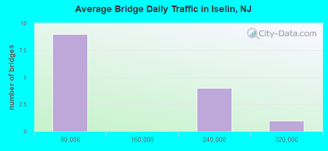
- 1,287,841Total average daily traffic
- 15,228Total average daily truck traffic
- National Bridge Inventory (NBI) Registered Bridges for Iselin
- No street view available for this location
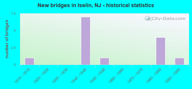
- New bridges - historical statistics
- 11910-1919
- 71940-1949
- 11950-1959
- 41980-1989
- 11990-1999
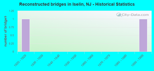
- Reconstructed bridges - Historical Statistics
- 11920-1929
- 01930-1939
- 01940-1949
- 01950-1959
- 01960-1969
- 01970-1979
- 01980-1989
- 11990-1999
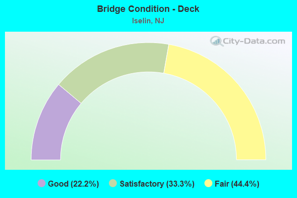
- Bridge Condition - Deck
- 22.2%Good
- 33.3%Satisfactory
- 44.4%Fair
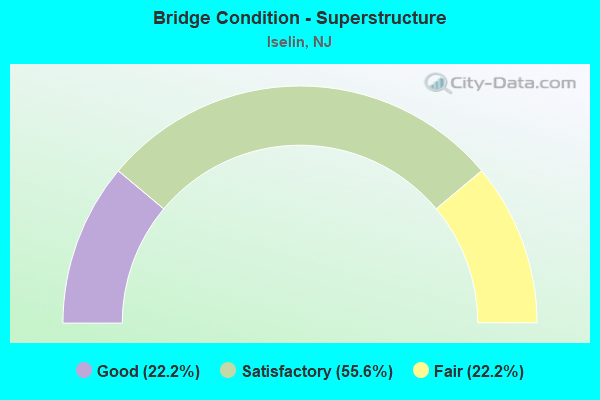
- Bridge Condition - Superstructure
- 22.2%Good
- 55.6%Satisfactory
- 22.2%Fair
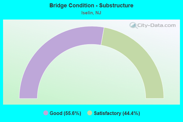
- Bridge Condition - Substructure
- 55.6%Good
- 44.4%Satisfactory
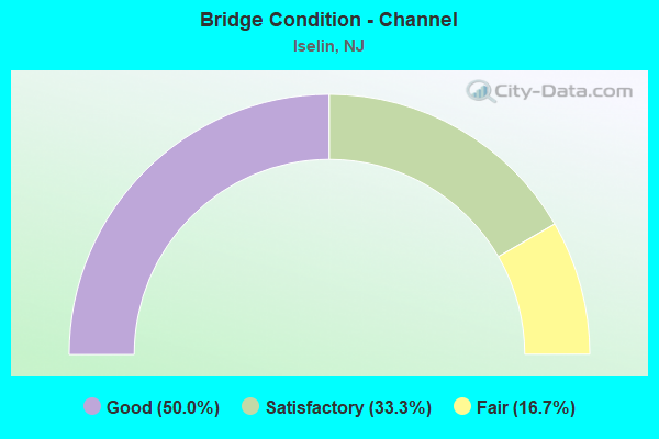
- Bridge Condition - Channel
- 50.0%Good
- 33.3%Satisfactory
- 16.7%Fair
Find on map >> Show street view
Structure Number: 1218158, Location: 0.75 MI North of 604 Jct. (Lat: 40.580419, Lng: -74.310400), Route carried "on" structure: State highway 27, Year Built: 1919, Year Reconstructed: 1926, Status: Open, Structure Length: 0.64m (2.10ft), Average Daily Traffic: 16,603 (year 2021), Truck Traffic: 4%, Average Future Daily Traffic: 20,259 (year 2041), Design Load: H 20, Features Intersected: S BRANCH RAHWAY RIVER
Minimum Vertical Clearance: 30+ m (98+ ft), Kilometerpoint: 41.602, Lanes on structure: 3, Base Highway Network: Yes, Owner: State Highway Agency, Approaching Roadway Width: 12.8m (42.0ft), Skew: 2 degrees, Material/Design: Concrete, Design/Construction: Arch - Deck, Number Of Spans In Main Unit: 1, Length of Maximum Span: 6.4m (21.0ft), Curb-To-Curb Width: 12.8m (42.0ft), Out-to-Out Width: 15.8m (51.8ft)
Condition: Deck: Fair, Superstructure: Fair, Substructure: Satisfactory, Channel: Fair, Operating Rating: 57.2 metric tons, Method Used To Determine Operating Rating: Load Factor (LF), Inventory Rating: 33.6 metric tons, Method Used To Determine Inventory Rating: Load Factor (LF), Structural Evaluation: Somewhat better than minimum adequacy, Deck Geometry: Meets minimum limits, Waterway Adequacy: Equal to present minimum criteria, Approach Roadway Alignment: Equal to present desirable criteria, Length Of Structure Improvement: 0.64m (2.10ft), Designated Inspection Frequency: Every 24 months, Inspection Date: May 2021, Bridge Improvement Cost: $250,000, Total Project Cost: $250,000 ( Estimate for 2021)
Find on map >> Show street view
Structure Number: 121B081, Location: AT INT. CHAIN-O-HILLS RD. (Lat: 40.572150, Lng: -74.314800), Route carried "on" structure: County highway 604, Year Built: 1984, Status: Open, Structure Length: 1.71m (5.61ft), Average Daily Traffic: 14,060 (year 2021), Truck Traffic: 4%, Average Future Daily Traffic: 17,156 (year 2041), Design Load: HS 20+Mod, Features Intersected: TRIB TO RAHWAY RIVER
Minimum Vertical Clearance: 30+ m (98+ ft), Kilometerpoint: 6.614, Lanes on structure: 3, Owner: County Highway Agency, Approaching Roadway Width: 14.0m (45.9ft), Material/Design: Prestressed concrete, Design/Construction: Box Beam or Girders - Multiple, Number Of Spans In Main Unit: 1, Length of Maximum Span: 15.8m (51.8ft), Curb or Sidewalk Widths: Left: 1.5m (4.9ft), Right: 1.5m (4.9ft), Curb-To-Curb Width: 14.1m (46.3ft), Out-to-Out Width: 17.9m (58.7ft)
Condition: Deck: Satisfactory, Superstructure: Satisfactory, Substructure: Good, Channel: Good, Operating Rating: 58.1 metric tons, Method Used To Determine Operating Rating: Load Factor (LF), Inventory Rating: 30.8 metric tons, Method Used To Determine Inventory Rating: Load Factor (LF), Structural Evaluation: Equal to present minimum criteria, Deck Geometry: Somewhat better than minimum adequacy, Waterway Adequacy: Superior to present desirable criteria, Approach Roadway Alignment: Better than present minimum criteria, Designated Inspection Frequency: Every 24 months, Inspection Date: April 2021, Deck Structure Type: Concrete Cast-file-Place, Wearing Surface/Protective System: Wearing Surface: Monolithic Concrete, Deck Protection: Epoxy Coated Reinforcing
Find on map >> Show street view
Structure Number: 121B084, Location: 0.3 MI S OF ROUTE 27 (Lat: 40.567581, Lng: -74.323311), Route carried "on" structure: City street , Year Built: 1995, Status: Open, Structure Length: 1.49m (4.89ft), Average Daily Traffic: 11,035 (year 2021), Truck Traffic: 1%, Average Future Daily Traffic: 13,460 (year 2041), Features Intersected: SO. BRANCH RAHWAY RIVER, Facility Carried by Structure: GILLS LANE
Minimum Vertical Clearance: 30+ m (98+ ft), Kilometerpoint: 0.000, Lanes on structure: 2, Owner: County Highway Agency, Approaching Roadway Width: 9.1m (29.9ft), Material/Design: Prestressed concrete, Design/Construction: Box Beam or Girders - Multiple, Number Of Spans In Main Unit: 1, Length of Maximum Span: 13.4m (44.0ft), Curb or Sidewalk Widths: Left: 1.5m (4.9ft), Right: 1.5m (4.9ft), Curb-To-Curb Width: 9.2m (30.2ft), Out-to-Out Width: 12.9m (42.3ft)
Condition: Deck: Satisfactory, Superstructure: Satisfactory, Substructure: Good, Channel: Satisfactory, Operating Rating: 83.5 metric tons, Method Used To Determine Operating Rating: Load Factor (LF), Inventory Rating: 49.9 metric tons, Method Used To Determine Inventory Rating: Load Factor (LF), Structural Evaluation: Equal to present minimum criteria, Deck Geometry: High priority of corrective action, Waterway Adequacy: Equal to present desirable criteria, Approach Roadway Alignment: Equal to present desirable criteria, Length Of Structure Improvement: 1.49m (4.89ft), Designated Inspection Frequency: Every 24 months, Inspection Date: March 2021, Bridge Improvement Cost: $20,000, Roadway Improvement Cost: $82,000, Total Project Cost: $190,000 ( Estimate for 2021), Deck Structure Type: Concrete Cast-file-Place, Wearing Surface/Protective System: Wearing Surface: Monolithic Concrete
Find on map >> Show street view
Structure Number: 121B506, Location: 0.15 miles south of NJ 27 (Lat: 40.565169, Lng: -74.330100), Route carried "on" structure: County highway 649, Year Built: 1950, Status: Open, Structure Length: 1.04m (3.41ft), Average Daily Traffic: 10,002 (year 2021), Truck Traffic: 4%, Average Future Daily Traffic: 12,205 (year 2041), Design Load: HS 20, Features Intersected: S. BR. RAHWAY RIVER
Minimum Vertical Clearance: 30+ m (98+ ft), Kilometerpoint: 0.708, Lanes on structure: 4, Owner: County Highway Agency, Approaching Roadway Width: 18.3m (60.0ft), Material/Design: Concrete continuous, Design/Construction: Slab, Number Of Spans In Main Unit: 2, Length of Maximum Span: 4.6m (15.1ft), Curb or Sidewalk Widths: Left: 1.8m (5.9ft), Right: 1.2m (3.9ft), Curb-To-Curb Width: 18.3m (60.0ft), Out-to-Out Width: 27.4m (89.9ft)
Condition: Deck: Fair, Superstructure: Fair, Substructure: Satisfactory, Channel: Satisfactory, Operating Rating: 54.4 metric tons, Method Used To Determine Operating Rating: Field evaluation and documented engineering judgment, Inventory Rating: 32.7 metric tons, Method Used To Determine Inventory Rating: Field evaluation and documented engineering judgment, Structural Evaluation: Somewhat better than minimum adequacy, Deck Geometry: Somewhat better than minimum adequacy, Waterway Adequacy: Better than present minimum criteria, Approach Roadway Alignment: Equal to present desirable criteria, Designated Inspection Frequency: Every 24 months, Inspection Date: May 2021, Deck Structure Type: Concrete Cast-file-Place, Wearing Surface/Protective System: Wearing Surface: Bituminous
Find on map >> Show street view
Structure Number: 361313T, Location: 0.65 MILES NORTH OF US 1 (Lat: 40.561942, Lng: -74.322778), Route carried "on" structure: Ramp Other road 444, Year Built: 1986, Status: Open, Structure Length: 10.21m (33.50ft), Average Daily Traffic: 9,014 (year 2021), Truck Traffic: 1%, Average Future Daily Traffic: 10,998 (year 2041), Design Load: HS 20+Mod, Features Intersected: GSP, Facility Carried by Structure: WOOD AVENUE
Minimum Vertical Clearance: 30+ m (98+ ft), Kilometerpoint: 211.355, Lanes on structure: 2, Lanes under structure: 11, Toll: On toll road, Owner: State Toll Authority, Approaching Roadway Width: 13.4m (44.0ft), Skew: 21 degrees, Material/Design: Steel, Design/Construction: Stringer/Multi-beam, Number Of Spans In Main Unit: 3, Length of Maximum Span: 39.3m (128.9ft), Curb-To-Curb Width: 13.4m (44.0ft), Out-to-Out Width: 14.9m (48.9ft)
Condition: Deck: Good, Superstructure: Good, Substructure: Satisfactory, Operating Rating: 52.8 metric tons, Method Used To Determine Operating Rating: Load and Resistance Factor Rating (LRFR) rating reported by rating factor(RF) method using HL-93 loadings, Inventory Rating: 40.8 metric tons, Method Used To Determine Inventory Rating: Load and Resistance Factor Rating (LRFR) rating reported by rating factor(RF) method using HL-93 loadings, Structural Evaluation: Equal to present minimum criteria, Deck Geometry: Superior to present desirable criteria, Underclear: Somewhat better than minimum adequacy, Approach Roadway Alignment: Equal to present desirable criteria, Designated Inspection Frequency: Every 24 months, Inspection Date: June 2021, Deck Structure Type: Concrete Cast-file-Place, Wearing Surface/Protective System: Wearing Surface: Monolithic Concrete, Deck Protection: Epoxy Coated Reinforcing
Find on map >> Show street view
Structure Number: 361314A, Location: JCT OF RMPS & STREAM (Lat: 40.563825, Lng: -74.321986), Route carried "on" structure: Ramp Other road GSP, Year Built: 1985, Status: Open, Structure Length: 0.67m (2.20ft), Average Daily Traffic: 9,161 (year 2021), Truck Traffic: 1%, Average Future Daily Traffic: 11,180 (year 2041), Design Load: HS 20+Mod, Features Intersected: S BRANCH OF RAHWAY RIVER
Minimum Vertical Clearance: 30+ m (98+ ft), Kilometerpoint: 211.468, Lanes on structure: 2, Toll: On toll road, Owner: State Toll Authority, Approaching Roadway Width: 15.2m (49.9ft), Skew: 20 degrees, Material/Design: Concrete, Design/Construction: Culvert, Number Of Spans In Main Unit: 2, Length of Maximum Span: 3.0m (9.8ft), Curb or Sidewalk Widths: Left: 0.0m, Right: 1.2m (3.9ft)
Condition: Channel: Good, Culverts: Satisfactory, Operating Rating: 96.9 metric tons, Method Used To Determine Operating Rating: Load and Resistance Factor Rating (LRFR) rating reported by rating factor(RF) method using HL-93 loadings, Inventory Rating: 96.9 metric tons, Method Used To Determine Inventory Rating: Load and Resistance Factor Rating (LRFR) rating reported by rating factor(RF) method using HL-93 loadings, Structural Evaluation: Equal to present minimum criteria, Waterway Adequacy: Better than present minimum criteria, Approach Roadway Alignment: Equal to present desirable criteria, Designated Inspection Frequency: Every 24 months, Inspection Date: June 2021
Find on map >> Show street view
Structure Number: 361317T, Location: 0.28 MI SOUTH OF RT27 (Lat: 40.567111, Lng: -74.325181), Route carried "on" structure: Other road GSP, Year Built: 1948, Year Reconstructed: 2003, Status: Open, Structure Length: 1.04m (3.41ft), Average Daily Traffic: 229,976 (year 2021), Truck Traffic: 1%, Average Future Daily Traffic: 280,615 (year 2041), Design Load: HS 20, Features Intersected: S BR RAHWAY RIVER, Facility Carried by Structure: GARDEN ST PARKWAY
Minimum Vertical Clearance: 30+ m (98+ ft), Kilometerpoint: 211.951, Lanes on structure: 11, Base Highway Network: Yes, Toll: On toll road, Owner: State Toll Authority, Approaching Roadway Width: 51.2m (168.0ft), Skew: 30 degrees, Material/Design: Steel, Design/Construction: Stringer/Multi-beam, Number Of Spans In Main Unit: 1, Length of Maximum Span: 9.4m (30.8ft), Curb-To-Curb Width: 53.3m (174.9ft), Out-to-Out Width: 55.2m (181.1ft)
Condition: Deck: Satisfactory, Superstructure: Satisfactory, Substructure: Good, Channel: Good, Operating Rating: 35.6 metric tons, Method Used To Determine Operating Rating: Load and Resistance Factor Rating (LRFR) rating reported by rating factor(RF) method using HL-93 loadings, Inventory Rating: 27.5 metric tons, Method Used To Determine Inventory Rating: Load and Resistance Factor Rating (LRFR) rating reported by rating factor(RF) method using HL-93 loadings, Structural Evaluation: Equal to present minimum criteria, Deck Geometry: Superior to present desirable criteria, Waterway Adequacy: Equal to present minimum criteria, Approach Roadway Alignment: Equal to present desirable criteria, Designated Inspection Frequency: Every 24 months, Inspection Date: June 2021, Deck Structure Type: Concrete Cast-file-Place, Wearing Surface/Protective System: Wearing Surface: Bituminous, Membrane: Preformed Fabric
Find on map >> Show street view
Structure Number: 361318T, Location: 0.20 MILE SOUTH OF RT 27 (Lat: 40.568592, Lng: -74.326558), Route carried "on" structure: County highway 657, Year Built: 1949, Status: Open, Structure Length: 4.60m (15.09ft), Average Daily Traffic: 22,856 (year 2021), Truck Traffic: 3%, Average Future Daily Traffic: 27,890 (year 2041), Design Load: HS 20, Features Intersected: GSP, Facility Carried by Structure: MIDDLESEX-ESSEX TP
Minimum Vertical Clearance: 30+ m (98+ ft), Kilometerpoint: 1.545, Lanes on structure: 2, Lanes under structure: 11, Owner: State Toll Authority, Approaching Roadway Width: 9.8m (32.2ft), Skew: 1 degrees, Material/Design: Steel continuous, Design/Construction: Girder and Floorbeam System, Number Of Spans In Main Unit: 2, Length of Maximum Span: 22.3m (73.2ft), Curb or Sidewalk Widths: Left: 1.7m (5.6ft), Right: 1.7m (5.6ft), Curb-To-Curb Width: 9.8m (32.2ft), Out-to-Out Width: 13.4m (44.0ft)
Condition: Deck: Fair, Superstructure: Satisfactory, Substructure: Good, Operating Rating: 40.8 metric tons, Method Used To Determine Operating Rating: Load and Resistance Factor Rating (LRFR) rating reported by rating factor(RF) method using HL-93 loadings, Inventory Rating: 31.4 metric tons, Method Used To Determine Inventory Rating: Load and Resistance Factor Rating (LRFR) rating reported by rating factor(RF) method using HL-93 loadings, Structural Evaluation: Equal to present minimum criteria, Deck Geometry: Meets minimum limits, Underclear: High priority of corrective action, Approach Roadway Alignment: Equal to present minimum criteria, Length Of Structure Improvement: 4.60m (15.09ft), Designated Inspection Frequency: Every 24 months, Critical Feature Inspection Frequency: Every 24 months, Inspection Date: June 2021, Critical Feature Inspection Date: June 2021, Bridge Improvement Cost: $35,000, Roadway Improvement Cost: $10,000, Total Project Cost: $50,000 ( Estimate for 2015), Deck Structure Type: Concrete Cast-file-Place, Wearing Surface/Protective System: Wearing Surface: Bituminous, Membrane: Preformed Fabric
Find on map >> Show street view
Structure Number: 361319T, Location: JCT OF 27 & GSP (Lat: 40.570072, Lng: -74.327728), Route carried "on" structure: State highway 27, Year Built: 1948, Status: Open, Structure Length: 4.91m (16.11ft), Average Daily Traffic: 22,610 (year 2021), Truck Traffic: 4%, Average Future Daily Traffic: 27,590 (year 2041), Design Load: HS 20, Features Intersected: GSP
Minimum Vertical Clearance: 30+ m (98+ ft), Kilometerpoint: 39.751, Lanes on structure: 4, Lanes under structure: 10, Base Highway Network: Yes, Owner: State Toll Authority, Approaching Roadway Width: 14.6m (47.9ft), Material/Design: Steel continuous, Design/Construction: Girder and Floorbeam System, Number Of Spans In Main Unit: 2, Length of Maximum Span: 23.8m (78.1ft), Curb or Sidewalk Widths: Left: 1.8m (5.9ft), Right: 1.4m (4.6ft), Curb-To-Curb Width: 14.6m (47.9ft), Out-to-Out Width: 18.4m (60.4ft)
Condition: Deck: Good, Superstructure: Satisfactory, Substructure: Good, Operating Rating: 31.4 metric tons, Method Used To Determine Operating Rating: Load and Resistance Factor Rating (LRFR) rating reported by rating factor(RF) method using HL-93 loadings, Inventory Rating: 24.3 metric tons, Method Used To Determine Inventory Rating: Load and Resistance Factor Rating (LRFR) rating reported by rating factor(RF) method using HL-93 loadings, Structural Evaluation: Equal to present minimum criteria, Deck Geometry: High priority of replacement, Underclear: High priority of corrective action, Approach Roadway Alignment: Equal to present desirable criteria, Length Of Structure Improvement: 4.91m (16.11ft), Designated Inspection Frequency: Every 24 months, Inspection Date: June 2021, Bridge Improvement Cost: $2,340,000, Roadway Improvement Cost: $400,000, Total Project Cost: $3,900,000 ( Estimate for 2017), Deck Structure Type: Concrete Cast-file-Place, Wearing Surface/Protective System: Wearing Surface: Bituminous
Find on map >> Show street view
Structure Number: 361322T, Location: 0.23 MI NORTH OF RT 27 (Lat: 40.573339, Lng: -74.329981), Route carried "on" structure: County highway 604, Year Built: 1948, Status: Open, Structure Length: 6.07m (19.91ft), Average Daily Traffic: 15,666 (year 2021), Truck Traffic: 1%, Average Future Daily Traffic: 19,116 (year 2041), Design Load: HS 20, Features Intersected: GSP, Facility Carried by Structure: OAK TREE ROAD
Minimum Vertical Clearance: 30+ m (98+ ft), Kilometerpoint: 5.279, Lanes on structure: 2, Lanes under structure: 12, Owner: State Toll Authority, Approaching Roadway Width: 12.2m (40.0ft), Skew: 1 degrees, Material/Design: Steel continuous, Design/Construction: Stringer/Multi-beam, Number Of Spans In Main Unit: 2, Length of Maximum Span: 29.6m (97.1ft), Curb or Sidewalk Widths: Left: 2.0m (6.6ft), Right: 2.0m (6.6ft), Curb-To-Curb Width: 12.2m (40.0ft), Out-to-Out Width: 17.2m (56.4ft)
Condition: Deck: Fair, Superstructure: Good, Substructure: Satisfactory, Operating Rating: 40.5 metric tons, Method Used To Determine Operating Rating: Load and Resistance Factor Rating (LRFR) rating reported by rating factor(RF) method using HL-93 loadings, Inventory Rating: 31.1 metric tons, Method Used To Determine Inventory Rating: Load and Resistance Factor Rating (LRFR) rating reported by rating factor(RF) method using HL-93 loadings, Structural Evaluation: Equal to present minimum criteria, Deck Geometry: Somewhat better than minimum adequacy, Underclear: High priority of replacement, Approach Roadway Alignment: Equal to present desirable criteria, Length Of Structure Improvement: 6.07m (19.91ft), Designated Inspection Frequency: Every 24 months, Inspection Date: June 2021, Bridge Improvement Cost: $4,000,000, Roadway Improvement Cost: $1,000,000, Total Project Cost: $600,000 ( Estimate for 2017), Deck Structure Type: Concrete Cast-file-Place, Wearing Surface/Protective System: Wearing Surface: Bituminous
Find on map >> Show street view
Structure Number: 361313T, Location: 0.65 MILES NORTH OF US 1 (Lat: 40.561942, Lng: -74.322778), Route carried "under" structure: Other road GSP, Year Built: 1986, Structure Length: 0. m, Average Daily Traffic: 214,848 (year 2021), Truck Traffic: 1%, Features Intersected: GSP, Facility Carried by Structure: WOOD AVENUE
Minimum Vertical Clearance: 7.37m (24.18ft), Kilometerpoint: 211.355, Lanes on structure: 2, Lanes under structure: 11, Toll: On toll road, Material/Design: Steel, Design/Construction: Stringer/Multi-beam, Length of Maximum Span: 39.3m (128.9ft)
Find on map >> Show street view
Structure Number: 361318T, Location: 0.20 MILE SOUTH OF RT 27 (Lat: 40.568592, Lng: -74.326558), Route carried "under" structure: Other road GSP, Year Built: 1949, Structure Length: 0. m, Average Daily Traffic: 219,236 (year 2021), Truck Traffic: 1%, Features Intersected: GSP, Facility Carried by Structure: MIDDLESEX-ESSEX TP
Minimum Vertical Clearance: 4.55m (14.93ft), Kilometerpoint: 212.160, Lanes on structure: 2, Lanes under structure: 11, Toll: On toll road, Material/Design: Steel continuous, Design/Construction: Girder and Floorbeam System, Length of Maximum Span: 22.3m (73.2ft)
Find on map >> Show street view
Structure Number: 361319T, Location: JCT OF 27 & GSP (Lat: 40.570072, Lng: -74.327728), Route carried "under" structure: Other road GSP, Year Built: 1948, Structure Length: 0. m, Average Daily Traffic: 196,363 (year 2021), Truck Traffic: 1%, Features Intersected: GSP, Facility Carried by Structure: NJ RTE 27
Minimum Vertical Clearance: 5.03m (16.50ft), Kilometerpoint: 212.385, Lanes on structure: 4, Lanes under structure: 10, Toll: On toll road, Material/Design: Steel continuous, Design/Construction: Girder and Floorbeam System, Length of Maximum Span: 23.8m (78.1ft)
Find on map >> Show street view
Structure Number: 361322T, Location: 0.23 MI NORTH OF RT 27 (Lat: 40.573339, Lng: -74.329981), Route carried "under" structure: Other road GSP, Year Built: 1948, Structure Length: 0. m, Average Daily Traffic: 296,411 (year 2021), Truck Traffic: 1%, Features Intersected: GSP, Facility Carried by Structure: OAK TREE ROAD
Minimum Vertical Clearance: 5.39m (17.68ft), Kilometerpoint: 212.771, Lanes on structure: 2, Lanes under structure: 12, Toll: On toll road, Material/Design: Steel continuous, Design/Construction: Stringer/Multi-beam, Length of Maximum Span: 29.6m (97.1ft)