Bridge Statistics for Ishpeming, Michigan (MI)
Condition, Traffic, Stress, Structural Evaluation, Project Costs
- National Bridge Inventory (NBI) Statistics
- 10Number of bridges
- 26ft / 8.4mTotal length
- 39,426Total average daily traffic
- 1,782Total average daily truck traffic
- National Bridge Inventory (NBI) Registered Bridges for Ishpeming
- No street view available for this location
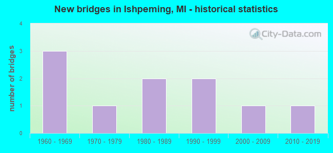
- New bridges - historical statistics
- 31960-1969
- 11970-1979
- 21980-1989
- 21990-1999
- 12000-2009
- 12010-2019
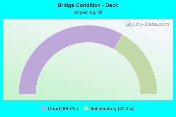
- Bridge Condition - Deck
- 66.7%Good
- 33.3%Satisfactory
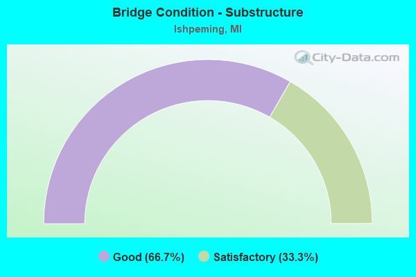
- Bridge Condition - Substructure
- 66.7%Good
- 33.3%Satisfactory
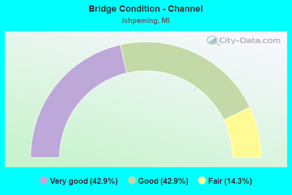
- Bridge Condition - Channel
- 42.9%Very good
- 42.9%Good
- 14.3%Fair
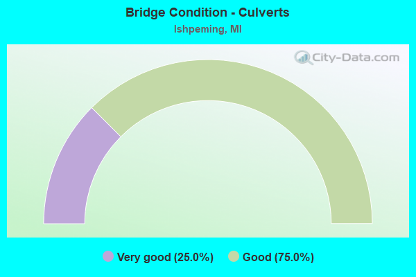
- Bridge Condition - Culverts
- 25.0%Very good
- 75.0%Good
Find on map >> Show street view
Structure Number: 6498, Location: IN ISHPEMING (Lat: 46.498383, Lng: -87.683156), Route carried "on" structure: US 41, Year Built: 1979, Status: Open, Structure Length: 1.22m (4.00ft), Average Daily Traffic: 13,542 (year 2007), Truck Traffic: 3%, Average Future Daily Traffic: 14,998 (year 2018), Design Load: HS 25 or greater, Features Intersected: CARP RIVER
Minimum Vertical Clearance: 30.48m (100.00ft), Kilometerpoint: 61.922, Lanes on structure: 5, Base Highway Network: Yes (Inventory Route: 156, Subroute: 9), Owner: State Highway Agency, Approaching Roadway Width: 25.9m (85.0ft), Skew: 2 degrees, Material/Design: Steel, Design/Construction: Stringer/Multi-beam, Number Of Spans In Main Unit: 1, Length of Maximum Span: 12.2m (40.0ft), Curb-To-Curb Width: 25.9m (85.0ft), Out-to-Out Width: 26.8m (87.9ft)
Condition: Deck: Satisfactory, Superstructure: Good, Substructure: Good, Channel: Good, Operating Rating: 94.9 metric tons, Method Used To Determine Operating Rating: Load Factor (LF) rating reported by rating factor (RF) method using MS18 loading, Inventory Rating: 56.7 metric tons, Method Used To Determine Inventory Rating: Load Factor (LF) rating reported by rating factor (RF) method using MS18 loading, Structural Evaluation: Better than present minimum criteria, Deck Geometry: Superior to present desirable criteria, Waterway Adequacy: Equal to present desirable criteria, Approach Roadway Alignment: Equal to present desirable criteria, Designated Inspection Frequency: Every 24 months, Inspection Date: June 2021, Deck Structure Type: Concrete Cast-file-Place, Wearing Surface/Protective System: Wearing Surface: Latex Concrete, Deck Protection: Epoxy Coated Reinforcing
Find on map >> Show street view
Structure Number: 6521, Location: W LIMITS OF ISHPEMING (Lat: 46.486358, Lng: -87.689433), Route carried "on" structure: City street , Year Built: 2010, Status: Open, Structure Length: 0.63m (2.07ft), Average Daily Traffic: 4,187 (year 2003), Truck Traffic: 30%, Average Future Daily Traffic: 4,800 (year 2023), Features Intersected: CARP RIVER CHANNEL, Facility Carried by Structure: OLD M-28 BR
Minimum Vertical Clearance: 30.48m (100.00ft), Kilometerpoint: 3.024, Lanes on structure: 2, Owner: City or Municipal Highway Agency, Approaching Roadway Width: 12.2m (40.0ft), Material/Design: Concrete, Design/Construction: Culvert, Number Of Spans In Main Unit: 1, Length of Maximum Span: 6.2m (20.3ft), Curb-To-Curb Width: 12.2m (40.0ft), Out-to-Out Width: 15.2m (49.9ft)
Condition: Channel: Very good, Culverts: Very good, Operating Rating: 64.8 metric tons, Method Used To Determine Operating Rating: Load and Resistance Factor Rating (LRFR) rating reported by rating factor(RF) method using HL-93 loadings, Inventory Rating: 51.8 metric tons, Method Used To Determine Inventory Rating: Load and Resistance Factor Rating (LRFR) rating reported by rating factor(RF) method using HL-93 loadings, Structural Evaluation: Equal to present desirable criteria, Deck Geometry: Equal to present minimum criteria, Waterway Adequacy: Equal to present desirable criteria, Approach Roadway Alignment: Equal to present desirable criteria, Designated Inspection Frequency: Every 24 months, Inspection Date: October 2021, Wearing Surface/Protective System: Wearing Surface: Bituminous, Membrane: Preformed Fabric
Find on map >> Show street view
Structure Number: 6547, Location: 1 MILE NORTH OF US-41 (Lat: 46.515125, Lng: -87.674928), Route carried "on" structure: County highway 5239, Year Built: 1982, Status: Open, Structure Length: 2.80m (9.19ft), Average Daily Traffic: 995 (year 2001), Average Future Daily Traffic: 1,005 (year 2020), Design Load: HS 20+Mod, Features Intersected: CARP RIVER, Facility Carried by Structure: COUNTY RD 573
Minimum Vertical Clearance: 30.48m (100.00ft), Kilometerpoint: 1.254, Lanes on structure: 2, Owner: County Highway Agency, Approaching Roadway Width: 8.5m (27.9ft), Skew: 4 degrees, Material/Design: Prestressed concrete, Design/Construction: Box Beam or Girders - Multiple, Number Of Spans In Main Unit: 1, Length of Maximum Span: 27.4m (89.9ft), Curb-To-Curb Width: 10.3m (33.8ft), Out-to-Out Width: 10.4m (34.1ft)
Condition: Deck: Good, Superstructure: Good, Substructure: Good, Channel: Very good, Operating Rating: 66.4 metric tons, Method Used To Determine Operating Rating: Load Factor (LF), Inventory Rating: 29.1 metric tons, Method Used To Determine Inventory Rating: Load Factor (LF), Structural Evaluation: Better than present minimum criteria, Deck Geometry: Equal to present minimum criteria, Waterway Adequacy: Better than present minimum criteria, Approach Roadway Alignment: Somewhat better than minimum adequacy, Designated Inspection Frequency: Every 24 months, Inspection Date: October 2020, Deck Structure Type: Concrete Cast-file-Place, Wearing Surface/Protective System: Wearing Surface: Bituminous, Deck Protection: Epoxy Coated Reinforcing
Find on map >> Show street view
Structure Number: 6548, Location: 6 MILES N OF ISHPEMING (Lat: 46.560711, Lng: -87.698869), Route carried "on" structure: County highway 5239, Year Built: 1983, Status: Open, Structure Length: 1.18m (3.87ft), Average Daily Traffic: 693 (year 2001), Average Future Daily Traffic: 707 (year 2020), Design Load: HS 20+Mod, Features Intersected: LITTLE DEAD RIVER, Facility Carried by Structure: COUNTY RD 573
Minimum Vertical Clearance: 30.48m (100.00ft), Kilometerpoint: 10.332, Lanes on structure: 2, Owner: County Highway Agency, Approaching Roadway Width: 10.3m (33.8ft), Material/Design: Prestressed concrete, Design/Construction: Box Beam or Girders - Multiple, Number Of Spans In Main Unit: 1, Length of Maximum Span: 10.9m (35.8ft), Curb-To-Curb Width: 10.3m (33.8ft), Out-to-Out Width: 10.4m (34.1ft)
Condition: Deck: Good, Superstructure: Good, Substructure: Satisfactory, Channel: Fair, Inventory Rating: 49.1 metric tons, Method Used To Determine Inventory Rating: Load Factor (LF), Structural Evaluation: Equal to present minimum criteria, Deck Geometry: Equal to present minimum criteria, Waterway Adequacy: Equal to present desirable criteria, Approach Roadway Alignment: Better than present minimum criteria, Designated Inspection Frequency: Every 24 months, Inspection Date: October 2020, Deck Structure Type: Concrete Cast-file-Place, Wearing Surface/Protective System: Wearing Surface: Bituminous, Deck Protection: Epoxy Coated Reinforcing
Find on map >> Show street view
Structure Number: 6621, Location: 0.1 MI N OF US-41/M-28 (Lat: 46.498914, Lng: -87.683175), Route carried "on" structure: City street , Year Built: 1993, Status: Open, Structure Length: 0.88m (2.89ft), Average Daily Traffic: 4,750 (year 1993), Average Future Daily Traffic: 7,160 (year 2012), Design Load: HS 20, Features Intersected: CARP CREEK, Facility Carried by Structure: LAKESHORE DRIVE
Minimum Vertical Clearance: 30.48m (100.00ft), Kilometerpoint: 0.052, Lanes on structure: 2, Owner: City or Municipal Highway Agency, Approaching Roadway Width: 7.3m (24.0ft), Skew: 4 degrees, Material/Design: Concrete, Design/Construction: Culvert, Number Of Spans In Main Unit: 2, Length of Maximum Span: 4.4m (14.4ft), Out-to-Out Width: 48.8m (160.1ft)
Condition: Channel: Very good, Culverts: Good, Operating Rating: 54.5 metric tons, Method Used To Determine Operating Rating: Field evaluation and documented engineering judgment, Inventory Rating: 32.7 metric tons, Method Used To Determine Inventory Rating: Field evaluation and documented engineering judgment, Structural Evaluation: Better than present minimum criteria, Waterway Adequacy: Superior to present desirable criteria, Approach Roadway Alignment: Equal to present desirable criteria, Designated Inspection Frequency: Every 24 months, Inspection Date: October 2021
Find on map >> Show street view
Structure Number: 6623, Location: 0.1 MI W OF LAKESHORE DR (Lat: 46.496344, Lng: -87.681517), Route carried "on" structure: City street , Year Built: 2006, Status: Open, Structure Length: 0.91m (2.99ft), Average Daily Traffic: 121 (year 2003), Truck Traffic: 15%, Average Future Daily Traffic: 232 (year 2025), Design Load: HS 20+Mod, Features Intersected: CARP RIVER, Facility Carried by Structure: CARSON ROAD
Minimum Vertical Clearance: 30.48m (100.00ft), Kilometerpoint: 0.023, Lanes on structure: 1, Owner: City or Municipal Highway Agency, Approaching Roadway Width: 9.1m (29.9ft), Material/Design: Concrete, Design/Construction: Culvert, Number Of Spans In Main Unit: 1, Length of Maximum Span: 8.5m (27.9ft), Curb-To-Curb Width: 10.4m (34.1ft), Out-to-Out Width: 14.6m (47.9ft)
Condition: Channel: Good, Culverts: Good, Operating Rating: 84.2 metric tons, Method Used To Determine Operating Rating: Load Factor (LF) rating reported by rating factor (RF) method using MS18 loading, Inventory Rating: 53.1 metric tons, Method Used To Determine Inventory Rating: Load Factor (LF) rating reported by rating factor (RF) method using MS18 loading, Structural Evaluation: Better than present minimum criteria, Deck Geometry: Better than present minimum criteria, Waterway Adequacy: Equal to present desirable criteria, Approach Roadway Alignment: Superior to present desirable criteria, Designated Inspection Frequency: Every 24 months, Inspection Date: October 2021
Find on map >> Show street view
Structure Number: 13479, Location: 0.1 M E OF N LAKESHORE DR (Lat: 46.502147, Lng: -87.681489), Route carried "on" structure: City street , Year Built: 1996, Status: Open, Structure Length: 0.79m (2.59ft), Average Daily Traffic: 1,000 (year 2008), Truck Traffic: 5%, Average Future Daily Traffic: 2,000 (year 2018), Design Load: HS 20, Features Intersected: CARP RIVER, Facility Carried by Structure: RIVER PARK RD
Minimum Vertical Clearance: 30.48m (100.00ft), Kilometerpoint: 0.410, Lanes on structure: 2, Owner: City or Municipal Highway Agency, Approaching Roadway Width: 12.2m (40.0ft), Material/Design: Concrete, Design/Construction: Culvert, Number Of Spans In Main Unit: 2, Length of Maximum Span: 3.7m (12.1ft), Curb-To-Curb Width: 11.9m (39.0ft), Out-to-Out Width: 12.2m (40.0ft)
Condition: Channel: Good, Culverts: Good, Operating Rating: 65.6 metric tons, Method Used To Determine Operating Rating: Field evaluation and documented engineering judgment, Inventory Rating: 39.2 metric tons, Method Used To Determine Inventory Rating: Field evaluation and documented engineering judgment, Structural Evaluation: Better than present minimum criteria, Deck Geometry: Better than present minimum criteria, Waterway Adequacy: Superior to present desirable criteria, Approach Roadway Alignment: Superior to present desirable criteria, Designated Inspection Frequency: Every 24 months, Inspection Date: October 2021, Deck Structure Type: Concrete Precast Panels, Wearing Surface/Protective System: Wearing Surface: Bituminous
Find on map >> Show street view
Structure Number: 6619, Location: 0.1 MI S OF US 41 OR M-28 (Lat: 46.502378, Lng: -87.666092), Route carried "under" structure: City street , Year Built: 1963, Structure Length: 0. m, Average Daily Traffic: 2,500 (year 1977), Features Intersected: SECOND STREET, Facility Carried by Structure: WCL RR
Minimum Vertical Clearance: 4.34m (14.24ft), Kilometerpoint: 0.698, Lanes under structure: 2, Material/Design: Steel, Design/Construction: Stringer/Multi-beam, Length of Maximum Span: 14.6m (47.9ft)
Find on map >> Show street view
Structure Number: 662, Location: 0.1 MI S OF US-41 OR M-28 (Lat: 46.502511, Lng: -87.664844), Route carried "under" structure: City street , Year Built: 1963, Structure Length: 0. m, Average Daily Traffic: 6,400 (year 1977), Features Intersected: THIRD STREET, Facility Carried by Structure: WCL RR
Minimum Vertical Clearance: 4.59m (15.06ft), Kilometerpoint: 0.410, Lanes under structure: 2, Material/Design: Steel, Design/Construction: Stringer/Multi-beam, Length of Maximum Span: 14.6m (47.9ft)
Find on map >> Show street view
Structure Number: 6622, Location: 0.1 MI S OF US-41 OR M-28 (Lat: 46.498089, Lng: -87.682517), Route carried "under" structure: Business State highway 28, Year Built: 1963, Structure Length: 0. m, Average Daily Traffic: 5,238 (year 2007), Truck Traffic: 1%, Features Intersected: M-28 BR (LAKESHORE DR), Facility Carried by Structure: WCL RR
Minimum Vertical Clearance: 4.93m (16.17ft), Kilometerpoint: 0.053, Lanes under structure: 2, Material/Design: Steel, Design/Construction: Stringer/Multi-beam, Length of Maximum Span: 14.9m (48.9ft)