Bridge Statistics for Ithaca, New York (NY)
Condition, Traffic, Stress, Structural Evaluation, Project Costs
- National Bridge Inventory (NBI) Statistics
- 35Number of bridges
- 377ft / 115mTotal length
- $81,222,000Total costs
- 236,184Total average daily traffic
- 10,215Total average daily truck traffic
- National Bridge Inventory (NBI) Registered Bridges for Ithaca
- No street view available for this location
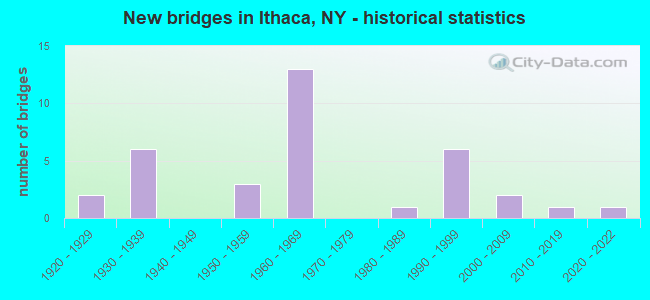
- New bridges - historical statistics
- 21920-1929
- 61930-1939
- 31950-1959
- 131960-1969
- 11980-1989
- 61990-1999
- 22000-2009
- 12010-2019
- 12020-2022
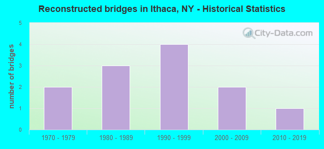
- Reconstructed bridges - Historical Statistics
- 21970-1979
- 31980-1989
- 41990-1999
- 22000-2009
- 12010-2019
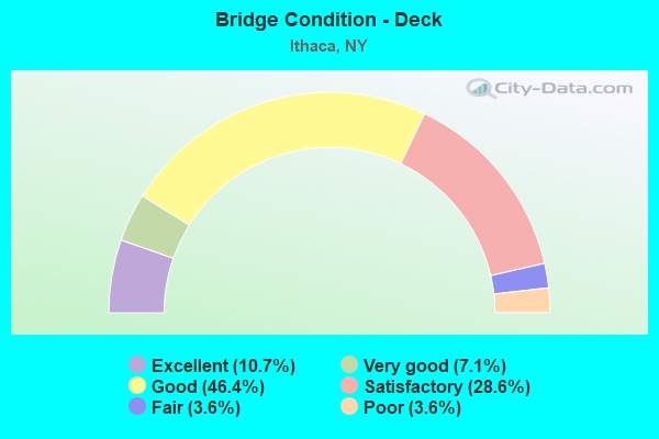
- Bridge Condition - Deck
- 10.7%Excellent
- 7.1%Very good
- 46.4%Good
- 28.6%Satisfactory
- 3.6%Fair
- 3.6%Poor
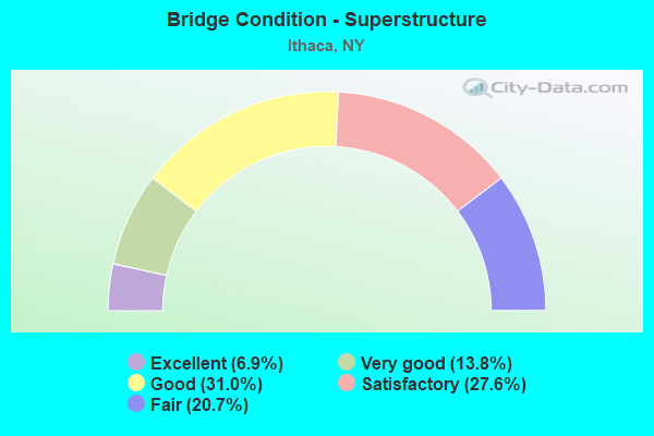
- Bridge Condition - Superstructure
- 6.9%Excellent
- 13.8%Very good
- 31.0%Good
- 27.6%Satisfactory
- 20.7%Fair
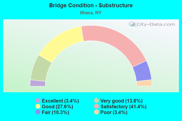
- Bridge Condition - Substructure
- 3.4%Excellent
- 13.8%Very good
- 27.6%Good
- 41.4%Satisfactory
- 10.3%Fair
- 3.4%Poor
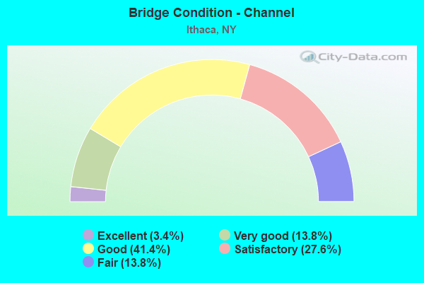
- Bridge Condition - Channel
- 3.4%Excellent
- 13.8%Very good
- 41.4%Good
- 27.6%Satisfactory
- 13.8%Fair
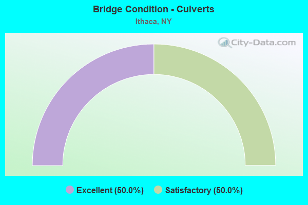
- Bridge Condition - Culverts
- 50.0%Excellent
- 50.0%Satisfactory
Find on map >> Show street view
Structure Number: 101035, Location: .1 MI S JCT SH 13 & SH 79 (Lat: 42.435892, Lng: -76.508172), Route carried "on" structure: State highway 13, Year Built: 1965, Status: Open, Structure Length: 3.57m (11.71ft), Average Daily Traffic: 19,501 (year 2020), Truck Traffic: 5%, Average Future Daily Traffic: 19,592 (year 2040), Design Load: HS 20, Features Intersected: SIXMILE CREEK
Minimum Vertical Clearance: 30+ m (98+ ft), Kilometerpoint: 22.993, Lanes on structure: 5, Base Highway Network: Yes, Owner: State Highway Agency, Approaching Roadway Width: 14.6m (47.9ft), Skew: 4 degrees, Material/Design: Steel, Design/Construction: Stringer/Multi-beam, Number Of Spans In Main Unit: 2, Length of Maximum Span: 16.7m (54.8ft), Curb or Sidewalk Widths: Left: 2.3m (7.5ft), Right: 1.5m (4.9ft), Curb-To-Curb Width: 18.3m (60.0ft), Out-to-Out Width: 22.9m (75.1ft)
Condition: Deck: Good, Superstructure: Fair, Substructure: Satisfactory, Channel: Good, Operating Rating: 66.2 metric tons, Method Used To Determine Operating Rating: Load Factor (LF), Inventory Rating: 39.0 metric tons, Method Used To Determine Inventory Rating: Load Factor (LF), Structural Evaluation: Somewhat better than minimum adequacy, Deck Geometry: High priority of replacement, Waterway Adequacy: Equal to present desirable criteria, Approach Roadway Alignment: Equal to present desirable criteria, Length Of Structure Improvement: 3.56m (11.68ft), Designated Inspection Frequency: Every 24 months, Inspection Date: July 2020, Bridge Improvement Cost: $2,318,000, Roadway Improvement Cost: $1,358,000, Total Project Cost: $3,676,000 ( Estimate for 2021), Deck Structure Type: Concrete Cast-file-Place, Wearing Surface/Protective System: Wearing Surface: Bituminous
Find on map >> Show street view
Structure Number: 101036, Location: 1.0 MI S JCT RTS 13 + 34 (Lat: 42.450772, Lng: -76.504231), Route carried "on" structure: State highway 13, Year Built: 1965, Status: Open, Structure Length: 1.52m (4.99ft), Average Daily Traffic: 23,657 (year 2011), Truck Traffic: 7%, Average Future Daily Traffic: 30,820 (year 2040), Design Load: HS 20, Features Intersected: CASCADILLA CREEK
Minimum Vertical Clearance: 30+ m (98+ ft), Kilometerpoint: 24.779, Lanes on structure: 4, Base Highway Network: Yes, Owner: State Highway Agency, Approaching Roadway Width: 21.6m (70.9ft), Skew: 21 degrees, Material/Design: Steel, Design/Construction: Stringer/Multi-beam, Number Of Spans In Main Unit: 1, Length of Maximum Span: 13.7m (44.9ft), Curb-To-Curb Width: 21.8m (71.5ft), Out-to-Out Width: 22.7m (74.5ft)
Condition: Deck: Satisfactory, Superstructure: Fair, Substructure: Satisfactory, Channel: Good, Operating Rating: 82.6 metric tons, Method Used To Determine Operating Rating: Load Factor (LF), Inventory Rating: 49.0 metric tons, Method Used To Determine Inventory Rating: Load Factor (LF), Structural Evaluation: Somewhat better than minimum adequacy, Deck Geometry: Better than present minimum criteria, Waterway Adequacy: Equal to present desirable criteria, Approach Roadway Alignment: Equal to present desirable criteria, Length Of Structure Improvement: 1.52m (4.99ft), Designated Inspection Frequency: Every 24 months, Inspection Date: September 2021, Bridge Improvement Cost: $1,344,000, Roadway Improvement Cost: $787,000, Total Project Cost: $2,130,000 ( Estimate for 2021), Deck Structure Type: Concrete Cast-file-Place, Wearing Surface/Protective System: Wearing Surface: Bituminous
Find on map >> Show street view
Structure Number: 101037, Location: 0.6 MI S JCT RTS 13 + 34 (Lat: 42.454778, Lng: -76.500722), Route carried "on" structure: State highway 13, Year Built: 1965, Status: Open, Structure Length: 3.72m (12.20ft), Average Daily Traffic: 23,657 (year 2011), Truck Traffic: 7%, Average Future Daily Traffic: 30,820 (year 2040), Design Load: HS 20, Features Intersected: FALL CREEK
Minimum Vertical Clearance: 30+ m (98+ ft), Kilometerpoint: 25.293, Lanes on structure: 4, Base Highway Network: Yes, Owner: State Highway Agency, Approaching Roadway Width: 17.7m (58.1ft), Skew: 22 degrees, Material/Design: Steel, Design/Construction: Stringer/Multi-beam, Number Of Spans In Main Unit: 1, Length of Maximum Span: 35.6m (116.8ft), Curb-To-Curb Width: 17.1m (56.1ft), Out-to-Out Width: 18.7m (61.4ft)
Condition: Deck: Good, Superstructure: Good, Substructure: Good, Channel: Satisfactory, Operating Rating: 52.6 metric tons, Method Used To Determine Operating Rating: Load Factor (LF), Inventory Rating: 31.8 metric tons, Method Used To Determine Inventory Rating: Load Factor (LF), Structural Evaluation: Better than present minimum criteria, Deck Geometry: High priority of corrective action, Waterway Adequacy: High priority of replacement, Approach Roadway Alignment: Equal to present desirable criteria, Length Of Structure Improvement: 3.71m (12.17ft), Designated Inspection Frequency: Every 24 months, Inspection Date: April 2020, Bridge Improvement Cost: $1,955,000, Roadway Improvement Cost: $1,145,000, Total Project Cost: $3,100,000 ( Estimate for 2021), Deck Structure Type: Concrete Cast-file-Place, Wearing Surface/Protective System: Wearing Surface: Bituminous
Find on map >> Show street view
Structure Number: 1010381, Location: JCT OF SH 13 SB & SH 34 (Lat: 42.463553, Lng: -76.498794), Route carried "on" structure: State highway 13, Year Built: 1964, Year Reconstructed: 1992, Status: Open, Structure Length: 7.32m (24.02ft), Average Daily Traffic: 9,590 (year 2020), Truck Traffic: 6%, Average Future Daily Traffic: 12,493 (year 2040), Design Load: HS 20, Features Intersected: RTE 34
Minimum Vertical Clearance: 30+ m (98+ ft), Kilometerpoint: 26.275, Lanes on structure: 3, Lanes under structure: 2, Base Highway Network: Yes, Owner: State Highway Agency, Approaching Roadway Width: 13.1m (43.0ft), Skew: 4 degrees, Material/Design: Steel, Design/Construction: Stringer/Multi-beam, Number Of Spans In Main Unit: 3, Length of Maximum Span: 33.2m (108.9ft), Curb-To-Curb Width: 12.4m (40.7ft), Out-to-Out Width: 13.2m (43.3ft)
Condition: Deck: Satisfactory, Superstructure: Satisfactory, Substructure: Satisfactory, Operating Rating: 85.3 metric tons, Method Used To Determine Operating Rating: Load Factor (LF), Inventory Rating: 50.8 metric tons, Method Used To Determine Inventory Rating: Load Factor (LF), Structural Evaluation: Equal to present minimum criteria, Deck Geometry: Meets minimum limits, Underclear: Better than present minimum criteria, Approach Roadway Alignment: Equal to present desirable criteria, Length Of Structure Improvement: 7.31m (23.98ft), Designated Inspection Frequency: Every 24 months, Inspection Date: April 2020, Bridge Improvement Cost: $2,089,000, Roadway Improvement Cost: $1,223,000, Total Project Cost: $3,313,000 ( Estimate for 2021), Deck Structure Type: Concrete Cast-file-Place, Wearing Surface/Protective System: Wearing Surface: Integral Concrete, Deck Protection: Epoxy Coated Reinforcing
Find on map >> Show street view
Structure Number: 1010382, Location: JCT OF SH 13 NB & SH 34 (Lat: 42.463383, Lng: -76.498703), Route carried "on" structure: State highway 13, Year Built: 1964, Year Reconstructed: 1992, Status: Open, Structure Length: 6.89m (22.60ft), Average Daily Traffic: 9,590 (year 2020), Truck Traffic: 6%, Average Future Daily Traffic: 12,493 (year 2040), Design Load: HS 20, Features Intersected: RTE 34
Minimum Vertical Clearance: 30+ m (98+ ft), Kilometerpoint: 26.259, Lanes on structure: 2, Lanes under structure: 2, Base Highway Network: Yes, Owner: State Highway Agency, Approaching Roadway Width: 9.4m (30.8ft), Skew: 4 degrees, Material/Design: Steel, Design/Construction: Stringer/Multi-beam, Number Of Spans In Main Unit: 3, Length of Maximum Span: 32.0m (105.0ft), Curb-To-Curb Width: 9.3m (30.5ft), Out-to-Out Width: 10.1m (33.1ft)
Condition: Deck: Good, Superstructure: Satisfactory, Substructure: Good, Operating Rating: 90.7 metric tons, Method Used To Determine Operating Rating: Load Factor (LF), Inventory Rating: 53.5 metric tons, Method Used To Determine Inventory Rating: Load Factor (LF), Structural Evaluation: Equal to present minimum criteria, Deck Geometry: Meets minimum limits, Underclear: Equal to present minimum criteria, Approach Roadway Alignment: Equal to present desirable criteria, Length Of Structure Improvement: 6.88m (22.57ft), Designated Inspection Frequency: Every 24 months, Inspection Date: April 2020, Bridge Improvement Cost: $1,494,000, Roadway Improvement Cost: $875,000, Total Project Cost: $2,369,000 ( Estimate for 2021), Deck Structure Type: Concrete Cast-file-Place, Wearing Surface/Protective System: Wearing Surface: Integral Concrete, Deck Protection: Epoxy Coated Reinforcing
Find on map >> Show street view
Structure Number: 101069, Location: 0.9 MI NE JCT RTS 13 &13A (Lat: 42.426703, Lng: -76.527219), Route carried "on" structure: State highway 13A, Year Built: 1987, Status: Open, Structure Length: 0.73m (2.40ft), Average Daily Traffic: 4,804 (year 2016), Truck Traffic: 5%, Average Future Daily Traffic: 5,835 (year 2040), Design Load: HS 20, Features Intersected: COY GLEN CREEK
Minimum Vertical Clearance: 30+ m (98+ ft), Kilometerpoint: 1.432, Lanes on structure: 2, Base Highway Network: Yes, Owner: State Highway Agency, Approaching Roadway Width: 9.8m (32.2ft), Skew: 4 degrees, Material/Design: Aluminum, Iron, Design/Construction: Culvert, Number Of Spans In Main Unit: 1, Length of Maximum Span: 7.0m (23.0ft)
Condition: Channel: Fair, Culverts: Satisfactory, Operating Rating: 77.6 metric tons, Method Used To Determine Operating Rating: Field evaluation and documented engineering judgment, Inventory Rating: 32.7 metric tons, Method Used To Determine Inventory Rating: Field evaluation and documented engineering judgment, Structural Evaluation: Equal to present minimum criteria, Waterway Adequacy: Meets minimum limits, Approach Roadway Alignment: Equal to present desirable criteria, Length Of Structure Improvement: 0.73m (2.40ft), Designated Inspection Frequency: Every 24 months, Inspection Date: November 2021, Bridge Improvement Cost: $165,000, Roadway Improvement Cost: $97,000, Total Project Cost: $262,000 ( Estimate for 2021)
Find on map >> Show street view
Structure Number: 107723, Location: JUST N JCT SH 79 & INLET (Lat: 42.441108, Lng: -76.514628), Route carried "on" structure: Spur State highway 96, Year Built: 1996, Status: Open, Structure Length: 7.38m (24.21ft), Average Daily Traffic: 10,441 (year 2020), Truck Traffic: 4%, Average Future Daily Traffic: 12,683 (year 2040), Design Load: HS 25 or greater, Features Intersected: FLOOD CONTROL CHANNEL
Minimum Vertical Clearance: 30+ m (98+ ft), Kilometerpoint: 20.885, Lanes on structure: 2, Base Highway Network: Yes, Owner: State Highway Agency, Approaching Roadway Width: 11.9m (39.0ft), Material/Design: Steel continuous, Design/Construction: Stringer/Multi-beam, Number Of Spans In Main Unit: 2, Length of Maximum Span: 39.3m (128.9ft), Curb or Sidewalk Widths: Left: 0.0m, Right: 3.0m (9.8ft), Curb-To-Curb Width: 9.8m (32.2ft), Out-to-Out Width: 14.3m (46.9ft)
Condition: Deck: Very good, Superstructure: Good, Substructure: Very good, Channel: Very good, Operating Rating: 89.8 metric tons, Method Used To Determine Operating Rating: Load Factor (LF), Inventory Rating: 55.3 metric tons, Method Used To Determine Inventory Rating: Load Factor (LF), Structural Evaluation: Better than present minimum criteria, Deck Geometry: Meets minimum limits, Waterway Adequacy: Equal to present desirable criteria, Approach Roadway Alignment: Equal to present desirable criteria, Length Of Structure Improvement: 7.37m (24.18ft), Designated Inspection Frequency: Every 24 months, Underwater Inspection Frequency: Every 60 months, Inspection Date: November 2020, Underwater Inspection Date: June 2019, Bridge Improvement Cost: $2,296,000, Roadway Improvement Cost: $1,345,000, Total Project Cost: $3,641,000 ( Estimate for 2021), Deck Structure Type: Concrete Cast-file-Place, Wearing Surface/Protective System: Wearing Surface: Integral Concrete, Deck Protection: Epoxy Coated Reinforcing
Find on map >> Show street view
Structure Number: 107724, Location: IN ITHACA (Lat: 42.443525, Lng: -76.513861), Route carried "on" structure: State highway 89, Year Built: 1997, Status: Open, Structure Length: 12.19m (39.99ft), Average Daily Traffic: 5,201 (year 2017), Truck Traffic: 4%, Average Future Daily Traffic: 6,435 (year 2040), Design Load: HS 25 or greater, Features Intersected: FLOOD CNT CHANNEL, CAYUG
Minimum Vertical Clearance: 30+ m (98+ ft), Kilometerpoint: 0.611, Lanes on structure: 2, Base Highway Network: Yes, Owner: State Highway Agency, Approaching Roadway Width: 8.5m (27.9ft), Skew: 2 degrees, Material/Design: Steel continuous, Design/Construction: Stringer/Multi-beam, Number Of Spans In Main Unit: 2, Length of Maximum Span: 61.5m (201.8ft), Curb or Sidewalk Widths: Left: 1.5m (4.9ft), Right: 1.5m (4.9ft), Curb-To-Curb Width: 8.5m (27.9ft), Out-to-Out Width: 12.3m (40.4ft)
Condition: Deck: Good, Superstructure: Very good, Substructure: Very good, Channel: Very good, Operating Rating: 89.8 metric tons, Method Used To Determine Operating Rating: Load Factor (LF), Inventory Rating: 48.1 metric tons, Method Used To Determine Inventory Rating: Load Factor (LF), Structural Evaluation: Equal to present desirable criteria, Deck Geometry: Meets minimum limits, Waterway Adequacy: Equal to present minimum criteria, Approach Roadway Alignment: Equal to present desirable criteria, Length Of Structure Improvement: 12.19m (39.99ft), Designated Inspection Frequency: Every 24 months, Underwater Inspection Frequency: Every 60 months, Inspection Date: August 2021, Underwater Inspection Date: August 2017, Bridge Improvement Cost: $3,221,000, Roadway Improvement Cost: $1,886,000, Total Project Cost: $5,107,000 ( Estimate for 2021), Deck Structure Type: Concrete Cast-file-Place, Wearing Surface/Protective System: Wearing Surface: Integral Concrete, Deck Protection: Epoxy Coated Reinforcing
Find on map >> Show street view
Structure Number: 22104, Location: IN CITY OF ITHACA (Lat: 42.439222, Lng: -76.512544), Route carried "on" structure: City street , Year Built: 2020, Status: Open, Structure Length: 3.69m (12.11ft), Average Daily Traffic: 1,852 (year 2016), Truck Traffic: 2%, Average Future Daily Traffic: 2,593 (year 2036), Design Load: HS 25 or greater, Features Intersected: CAYUGA INLET, Facility Carried by Structure: BRINDLEY STREET
Minimum Vertical Clearance: 32.69m (107.25ft), Kilometerpoint: 0.080, Lanes on structure: 2, Owner: City or Municipal Highway Agency, Approaching Roadway Width: 10.4m (34.1ft), Material/Design: Steel, Design/Construction: Stringer/Multi-beam, Number Of Spans In Main Unit: 1, Length of Maximum Span: 35.1m (115.2ft), Curb or Sidewalk Widths: Left: 1.5m (4.9ft), Right: 1.5m (4.9ft), Curb-To-Curb Width: 10.4m (34.1ft), Out-to-Out Width: 14.7m (48.2ft)
Condition: Deck: Excellent, Superstructure: Excellent, Substructure: Excellent, Channel: Excellent, Operating Rating: 97.6 metric tons, Method Used To Determine Operating Rating: Field evaluation and documented engineering judgment, Inventory Rating: 40.8 metric tons, Method Used To Determine Inventory Rating: Field evaluation and documented engineering judgment, Structural Evaluation: Superior to present desirable criteria, Deck Geometry: Equal to present minimum criteria, Waterway Adequacy: Superior to present desirable criteria, Approach Roadway Alignment: High priority of corrective action, Length Of Structure Improvement: 3.68m (12.07ft), Designated Inspection Frequency: Every 24 months, Inspection Date: September 2020, Bridge Improvement Cost: $1,045,000, Roadway Improvement Cost: $612,000, Total Project Cost: $1,656,000 ( Estimate for 2021), Deck Structure Type: Concrete Cast-file-Place, Wearing Surface/Protective System: Wearing Surface: Monolithic Concrete, Deck Protection: Epoxy Coated Reinforcing
Find on map >> Show street view
Structure Number: 221042, Location: IN CITY OF ITHACA (Lat: 42.434433, Lng: -76.501469), Route carried "on" structure: City street , Year Built: 1926, Year Reconstructed: 1984, Status: Open, Structure Length: 2.77m (9.09ft), Average Daily Traffic: 1,765 (year 2020), Truck Traffic: 2%, Average Future Daily Traffic: 2,144 (year 2040), Design Load: HS 20+Mod, Features Intersected: SIXMILE CREEK, Facility Carried by Structure: SOUTH ALBANY ST.
Minimum Vertical Clearance: 30+ m (98+ ft), Kilometerpoint: 0.290, Lanes on structure: 2, Owner: City or Municipal Highway Agency, Approaching Roadway Width: 8.8m (28.9ft), Skew: 2 degrees, Material/Design: Steel, Design/Construction: Girder and Floorbeam System, Number Of Spans In Main Unit: 1, Length of Maximum Span: 26.2m (86.0ft), Curb or Sidewalk Widths: Left: 1.8m (5.9ft), Right: 1.8m (5.9ft), Curb-To-Curb Width: 9.2m (30.2ft), Out-to-Out Width: 9.4m (30.8ft)
Condition: Deck: Satisfactory, Superstructure: Satisfactory, Substructure: Satisfactory, Channel: Satisfactory, Operating Rating: 62.6 metric tons, Method Used To Determine Operating Rating: Load Factor (LF), Inventory Rating: 37.2 metric tons, Method Used To Determine Inventory Rating: Load Factor (LF), Structural Evaluation: Equal to present minimum criteria, Deck Geometry: Somewhat better than minimum adequacy, Waterway Adequacy: Equal to present desirable criteria, Approach Roadway Alignment: Equal to present minimum criteria, Length Of Structure Improvement: 2.77m (9.09ft), Designated Inspection Frequency: Every 24 months, Critical Feature Inspection Frequency: Every 12 months, Inspection Date: November 2021, Critical Feature Inspection Date: November 2021, Bridge Improvement Cost: $718,000, Roadway Improvement Cost: $420,000, Total Project Cost: $1,138,000 ( Estimate for 2021), Deck Structure Type: Concrete Cast-file-Place, Wearing Surface/Protective System: Wearing Surface: Integral Concrete, Deck Protection: Epoxy Coated Reinforcing
Find on map >> Show street view
Structure Number: 221043, Location: ITHACA (Lat: 42.435333, Lng: -76.498825), Route carried "on" structure: City street , Year Built: 1968, Status: Open, Structure Length: 2.23m (7.32ft), Average Daily Traffic: 7,535 (year 2020), Truck Traffic: 3%, Average Future Daily Traffic: 9,323 (year 2040), Features Intersected: SIX MILE CREEK, Facility Carried by Structure: SOUTH CAYUGA ST.
Minimum Vertical Clearance: 30+ m (98+ ft), Kilometerpoint: 0.338, Lanes on structure: 2, Owner: City or Municipal Highway Agency, Approaching Roadway Width: 7.9m (25.9ft), Skew: 3 degrees, Material/Design: Steel, Design/Construction: Stringer/Multi-beam, Number Of Spans In Main Unit: 1, Length of Maximum Span: 21.6m (70.9ft), Curb or Sidewalk Widths: Left: 1.5m (4.9ft), Right: 1.5m (4.9ft), Curb-To-Curb Width: 7.9m (25.9ft), Out-to-Out Width: 11.6m (38.1ft)
Condition: Deck: Fair, Superstructure: Fair, Substructure: Fair, Channel: Fair, Operating Rating: 32.7 metric tons, Method Used To Determine Operating Rating: Load Factor (LF), Inventory Rating: 19.1 metric tons, Method Used To Determine Inventory Rating: Load Factor (LF), Structural Evaluation: Meets minimum limits, Deck Geometry: High priority of replacement, Waterway Adequacy: Meets minimum limits, Approach Roadway Alignment: Better than present minimum criteria, Length Of Structure Improvement: 2.22m (7.28ft), Designated Inspection Frequency: Every 24 months, Underwater Inspection Frequency: Every 60 months, Inspection Date: September 2021, Underwater Inspection Date: June 2019, Bridge Improvement Cost: $1,012,000, Roadway Improvement Cost: $593,000, Total Project Cost: $1,604,000 ( Estimate for 2021), Deck Structure Type: Concrete Cast-file-Place, Wearing Surface/Protective System: Wearing Surface: Integral Concrete
Find on map >> Show street view
Structure Number: 221044, Location: .5 MI E JCT SH 96B & SH13 (Lat: 42.436900, Lng: -76.498022), Route carried "on" structure: City street 96B, Year Built: 2012, Status: Open, Structure Length: 2.77m (9.09ft), Average Daily Traffic: 8,836 (year 2018), Truck Traffic: 2%, Average Future Daily Traffic: 10,733 (year 2040), Design Load: HL 93, Features Intersected: SIXMILE CREEK
Minimum Vertical Clearance: 30+ m (98+ ft), Kilometerpoint: 17.377, Lanes on structure: 2, Base Highway Network: Yes, Owner: City or Municipal Highway Agency, Approaching Roadway Width: 9.8m (32.2ft), Material/Design: Steel, Design/Construction: Stringer/Multi-beam, Number Of Spans In Main Unit: 1, Length of Maximum Span: 25.9m (85.0ft), Curb or Sidewalk Widths: Left: 2.1m (6.9ft), Right: 1.8m (5.9ft), Curb-To-Curb Width: 9.1m (29.9ft), Out-to-Out Width: 13.8m (45.3ft)
Condition: Deck: Very good, Superstructure: Very good, Substructure: Good, Channel: Good, Operating Rating: 81.6 metric tons, Method Used To Determine Operating Rating: Load Factor (LF), Inventory Rating: 48.1 metric tons, Method Used To Determine Inventory Rating: Load Factor (LF), Structural Evaluation: Better than present minimum criteria, Deck Geometry: High priority of corrective action, Waterway Adequacy: Equal to present minimum criteria, Approach Roadway Alignment: Equal to present desirable criteria, Length Of Structure Improvement: 2.77m (9.09ft), Designated Inspection Frequency: Every 24 months, Inspection Date: October 2020, Bridge Improvement Cost: $1,228,000, Roadway Improvement Cost: $719,000, Total Project Cost: $1,946,000 ( Estimate for 2021), Deck Structure Type: Concrete Cast-file-Place, Wearing Surface/Protective System: Wearing Surface: Integral Concrete, Deck Protection: Epoxy Coated Reinforcing
Find on map >> Show street view
Structure Number: 221045, Location: 0.8 MI E JCT RTS 79 + 13 (Lat: 42.438828, Lng: -76.495219), Route carried "on" structure: City street , Year Built: 1957, Year Reconstructed: 2007, Status: Open, Structure Length: 3.93m (12.89ft), Average Daily Traffic: 6,416 (year 2020), Truck Traffic: 3%, Average Future Daily Traffic: 7,794 (year 2040), Design Load: HS 20+Mod, Features Intersected: RTE 79, SIX MILE CREEK, Facility Carried by Structure: SOUTH AURORA ST
Minimum Vertical Clearance: 30+ m (98+ ft), Kilometerpoint: 0.129, Lanes on structure: 2, Lanes under structure: 2, Owner: City or Municipal Highway Agency, Approaching Roadway Width: 10.2m (33.5ft), Material/Design: Steel, Design/Construction: Stringer/Multi-beam, Number Of Spans In Main Unit: 2, Length of Maximum Span: 21.9m (71.9ft), Curb or Sidewalk Widths: Left: 2.0m (6.6ft), Right: 2.0m (6.6ft), Curb-To-Curb Width: 10.2m (33.5ft), Out-to-Out Width: 14.9m (48.9ft)
Condition: Deck: Good, Superstructure: Good, Substructure: Satisfactory, Channel: Satisfactory, Operating Rating: 67.1 metric tons, Method Used To Determine Operating Rating: Load Factor (LF), Inventory Rating: 39.9 metric tons, Method Used To Determine Inventory Rating: Load Factor (LF), Structural Evaluation: Equal to present minimum criteria, Deck Geometry: Meets minimum limits, Underclear: Meets minimum limits, Waterway Adequacy: Meets minimum limits, Approach Roadway Alignment: Equal to present desirable criteria, Length Of Structure Improvement: 3.93m (12.89ft), Designated Inspection Frequency: Every 24 months, Underwater Inspection Frequency: Every 60 months, Inspection Date: October 2021, Underwater Inspection Date: September 2021, Bridge Improvement Cost: $1,505,000, Roadway Improvement Cost: $881,000, Total Project Cost: $2,386,000 ( Estimate for 2021), Deck Structure Type: Concrete Cast-file-Place, Wearing Surface/Protective System: Wearing Surface: Integral Concrete, Deck Protection: Epoxy Coated Reinforcing
Find on map >> Show street view
Structure Number: 221047, Location: CITY OF ITHACA (Lat: 42.433244, Lng: -76.485081), Route carried "on" structure: City street , Year Built: 1960, Status: Open, Structure Length: 5.64m (18.50ft), Average Daily Traffic: 2,879 (year 2018), Truck Traffic: 1%, Average Future Daily Traffic: 3,562 (year 2040), Design Load: HS 20, Features Intersected: SIXMILE CREEK, Facility Carried by Structure: GILES STREET
Minimum Vertical Clearance: 30+ m (98+ ft), Kilometerpoint: 0.917, Lanes on structure: 2, Owner: City or Municipal Highway Agency, Approaching Roadway Width: 7.3m (24.0ft), Skew: 2 degrees, Material/Design: Steel, Design/Construction: Stringer/Multi-beam, Number Of Spans In Main Unit: 3, Length of Maximum Span: 22.9m (75.1ft), Curb or Sidewalk Widths: Left: 0.0m, Right: 1.5m (4.9ft), Curb-To-Curb Width: 7.4m (24.3ft), Out-to-Out Width: 10.1m (33.1ft)
Condition: Deck: Good, Superstructure: Very good, Substructure: Good, Channel: Satisfactory, Operating Rating: 63.5 metric tons, Method Used To Determine Operating Rating: Load Factor (LF), Inventory Rating: 38.1 metric tons, Method Used To Determine Inventory Rating: Load Factor (LF), Structural Evaluation: Better than present minimum criteria, Deck Geometry: High priority of replacement, Waterway Adequacy: Somewhat better than minimum adequacy, Approach Roadway Alignment: Equal to present minimum criteria, Length Of Structure Improvement: 5.63m (18.47ft), Designated Inspection Frequency: Every 24 months, Underwater Inspection Frequency: Every 60 months, Inspection Date: November 2020, Underwater Inspection Date: May 2018, Bridge Improvement Cost: $1,348,000, Roadway Improvement Cost: $789,000, Total Project Cost: $2,137,000 ( Estimate for 2021), Deck Structure Type: Concrete Cast-file-Place, Wearing Surface/Protective System: Wearing Surface: Integral Concrete, Deck Protection: Epoxy Coated Reinforcing
Find on map >> Show street view
Structure Number: 221049, Location: CITY OF ITHACA (Lat: 42.447853, Lng: -76.501889), Route carried "on" structure: City street , Year Built: 1931, Status: Open, Structure Length: 1.37m (4.49ft), Average Daily Traffic: 1,806 (year 2018), Truck Traffic: 4%, Average Future Daily Traffic: 2,234 (year 2040), Features Intersected: CASCADILLA CREEK, Facility Carried by Structure: HANCOCK STREET
Minimum Vertical Clearance: 30+ m (98+ ft), Kilometerpoint: 0.628, Lanes on structure: 2, Owner: City or Municipal Highway Agency, Approaching Roadway Width: 8.5m (27.9ft), Material/Design: Steel, Design/Construction: Stringer/Multi-beam, Number Of Spans In Main Unit: 1, Length of Maximum Span: 13.1m (43.0ft), Curb or Sidewalk Widths: Left: 1.7m (5.6ft), Right: 1.7m (5.6ft), Curb-To-Curb Width: 8.5m (27.9ft), Out-to-Out Width: 12.8m (42.0ft)
Condition: Deck: Satisfactory, Superstructure: Good, Substructure: Fair, Channel: Satisfactory, Operating Rating: 50.8 metric tons, Method Used To Determine Operating Rating: Load Factor (LF), Inventory Rating: 29.9 metric tons, Method Used To Determine Inventory Rating: Load Factor (LF), Structural Evaluation: Somewhat better than minimum adequacy, Deck Geometry: Somewhat better than minimum adequacy, Waterway Adequacy: Somewhat better than minimum adequacy, Approach Roadway Alignment: Equal to present desirable criteria, Length Of Structure Improvement: 1.37m (4.49ft), Designated Inspection Frequency: Every 24 months, Inspection Date: July 2021, Bridge Improvement Cost: $686,000, Roadway Improvement Cost: $402,000, Total Project Cost: $1,088,000 ( Estimate for 2021), Deck Structure Type: Concrete Cast-file-Place, Wearing Surface/Protective System: Wearing Surface: Bituminous, Membrane: Other
Find on map >> Show street view
Structure Number: 22105, Location: CITY OF ITHACA (Lat: 42.446925, Lng: -76.501153), Route carried "on" structure: City street , Year Built: 1920, Year Reconstructed: 1988, Status: Open, Structure Length: 1.43m (4.69ft), Average Daily Traffic: 368 (year 2019), Truck Traffic: 4%, Average Future Daily Traffic: 515 (year 2039), Features Intersected: CASCADILLA CREEK, Facility Carried by Structure: MADISON STREET
Minimum Vertical Clearance: 30+ m (98+ ft), Kilometerpoint: 0.000, Lanes on structure: 2, Owner: City or Municipal Highway Agency, Approaching Roadway Width: 8.5m (27.9ft), Material/Design: Steel, Design/Construction: Stringer/Multi-beam, Number Of Spans In Main Unit: 1, Length of Maximum Span: 14.0m (45.9ft), Curb or Sidewalk Widths: Left: 1.9m (6.2ft), Right: 1.9m (6.2ft), Curb-To-Curb Width: 8.5m (27.9ft), Out-to-Out Width: 12.8m (42.0ft)
Condition: Deck: Satisfactory, Superstructure: Good, Substructure: Fair, Channel: Satisfactory, Operating Rating: 70.8 metric tons, Method Used To Determine Operating Rating: Load Factor (LF), Inventory Rating: 41.7 metric tons, Method Used To Determine Inventory Rating: Load Factor (LF), Structural Evaluation: Somewhat better than minimum adequacy, Deck Geometry: Equal to present minimum criteria, Waterway Adequacy: Somewhat better than minimum adequacy, Approach Roadway Alignment: Equal to present desirable criteria, Length Of Structure Improvement: 1.43m (4.69ft), Designated Inspection Frequency: Every 24 months, Inspection Date: August 2021, Bridge Improvement Cost: $644,000, Roadway Improvement Cost: $377,000, Total Project Cost: $1,021,000 ( Estimate for 2021), Deck Structure Type: Concrete Cast-file-Place, Wearing Surface/Protective System: Wearing Surface: Bituminous, Membrane: Other, Deck Protection: Epoxy Coated Reinforcing
Find on map >> Show street view
Structure Number: 221052, Location: CITY OF ITHACA (Lat: 42.444753, Lng: -76.499261), Route carried "on" structure: City street , Year Built: 1992, Status: Open, Structure Length: 1.28m (4.20ft), Average Daily Traffic: 4,330 (year 2020), Truck Traffic: 4%, Average Future Daily Traffic: 5,260 (year 2040), Features Intersected: CASCADILLA CREEK, Facility Carried by Structure: NORTH CAYUGA ST
Minimum Vertical Clearance: 30+ m (98+ ft), Kilometerpoint: 1.368, Lanes on structure: 2, Owner: City or Municipal Highway Agency, Approaching Roadway Width: 11.0m (36.1ft), Skew: 4 degrees, Material/Design: Prestressed concrete, Design/Construction: Box Beam or Girders - Multiple, Number Of Spans In Main Unit: 1, Length of Maximum Span: 12.4m (40.7ft), Curb or Sidewalk Widths: Left: 1.9m (6.2ft), Right: 1.9m (6.2ft), Curb-To-Curb Width: 10.9m (35.8ft), Out-to-Out Width: 15.5m (50.9ft)
Condition: Deck: Satisfactory, Superstructure: Satisfactory, Substructure: Good, Channel: Satisfactory, Operating Rating: 39.0 metric tons, Method Used To Determine Operating Rating: Load Factor (LF), Inventory Rating: 17.2 metric tons, Method Used To Determine Inventory Rating: Load Factor (LF), Structural Evaluation: Meets minimum limits, Deck Geometry: Somewhat better than minimum adequacy, Waterway Adequacy: Somewhat better than minimum adequacy, Approach Roadway Alignment: Better than present minimum criteria, Length Of Structure Improvement: 1.28m (4.20ft), Designated Inspection Frequency: Every 24 months, Inspection Date: October 2020, Bridge Improvement Cost: $834,000, Roadway Improvement Cost: $488,000, Total Project Cost: $1,323,000 ( Estimate for 2021), Wearing Surface/Protective System: Wearing Surface: Bituminous, Membrane: Other
Find on map >> Show street view
Structure Number: 221054, Location: CITY OF ITHACA (Lat: 42.443858, Lng: -76.497028), Route carried "on" structure: City street , Year Built: 1930, Year Reconstructed: 1982, Status: Open, Structure Length: 1.04m (3.41ft), Average Daily Traffic: 778 (year 2020), Truck Traffic: 2%, Average Future Daily Traffic: 962 (year 2040), Features Intersected: CASCADILLA CREEK, Facility Carried by Structure: N TIOGA STREET
Minimum Vertical Clearance: 30+ m (98+ ft), Kilometerpoint: 0.370, Lanes on structure: 2, Owner: City or Municipal Highway Agency, Approaching Roadway Width: 11.3m (37.1ft), Skew: 2 degrees, Material/Design: Prestressed concrete, Design/Construction: Box Beam or Girders - Multiple, Number Of Spans In Main Unit: 1, Length of Maximum Span: 9.7m (31.8ft), Curb or Sidewalk Widths: Left: 2.0m (6.6ft), Right: 2.0m (6.6ft), Curb-To-Curb Width: 11.1m (36.4ft), Out-to-Out Width: 16.0m (52.5ft)
Condition: Deck: Good, Superstructure: Satisfactory, Substructure: Good, Channel: Good, Operating Rating: 56.2 metric tons, Method Used To Determine Operating Rating: Load Factor (LF), Inventory Rating: 32.7 metric tons, Method Used To Determine Inventory Rating: Load Factor (LF), Structural Evaluation: Equal to present minimum criteria, Deck Geometry: Better than present minimum criteria, Waterway Adequacy: Somewhat better than minimum adequacy, Approach Roadway Alignment: Equal to present desirable criteria, Length Of Structure Improvement: 1.03m (3.38ft), Designated Inspection Frequency: Every 24 months, Inspection Date: April 2021, Bridge Improvement Cost: $657,000, Roadway Improvement Cost: $385,000, Total Project Cost: $1,041,000 ( Estimate for 2021), Wearing Surface/Protective System: Wearing Surface: Bituminous
Find on map >> Show street view
Structure Number: 221055, Location: CITY OF ITHACA (Lat: 42.443547, Lng: -76.495839), Route carried "on" structure: City street , Year Built: 1930, Year Reconstructed: 2019, Status: Open, Structure Length: 1.01m (3.31ft), Average Daily Traffic: 1,711 (year 2020), Truck Traffic: 2%, Average Future Daily Traffic: 2,078 (year 2040), Features Intersected: CASCADILLA CREEK, Facility Carried by Structure: NORTH AURORA ST
Minimum Vertical Clearance: 30+ m (98+ ft), Kilometerpoint: 0.708, Lanes on structure: 2, Owner: City or Municipal Highway Agency, Approaching Roadway Width: 10.1m (33.1ft), Skew: 2 degrees, Material/Design: Steel, Design/Construction: Stringer/Multi-beam, Number Of Spans In Main Unit: 1, Length of Maximum Span: 9.7m (31.8ft), Curb or Sidewalk Widths: Left: 4.8m (15.7ft), Right: 4.5m (14.8ft), Curb-To-Curb Width: 9.9m (32.5ft), Out-to-Out Width: 19.9m (65.3ft)
Condition: Deck: Excellent, Superstructure: Excellent, Substructure: Satisfactory, Channel: Fair, Operating Rating: 91.6 metric tons, Method Used To Determine Operating Rating: Load Factor (LF), Inventory Rating: 55.3 metric tons, Method Used To Determine Inventory Rating: Load Factor (LF), Structural Evaluation: Equal to present minimum criteria, Deck Geometry: Somewhat better than minimum adequacy, Waterway Adequacy: Meets minimum limits, Approach Roadway Alignment: Equal to present desirable criteria, Length Of Structure Improvement: 1.00m (3.28ft), Designated Inspection Frequency: Every 24 months, Inspection Date: November 2021, Bridge Improvement Cost: $658,000, Roadway Improvement Cost: $385,000, Total Project Cost: $1,043,000 ( Estimate for 2021), Deck Structure Type: Concrete Cast-file-Place, Wearing Surface/Protective System: Wearing Surface: Integral Concrete
Find on map >> Show street view
Structure Number: 221056, Location: CITY OF ITHACA (Lat: 42.442828, Lng: -76.494569), Route carried "on" structure: City street , Year Built: 2001, Status: Open, Structure Length: 1.04m (3.41ft), Average Daily Traffic: 319 (year 2016), Truck Traffic: 1%, Average Future Daily Traffic: 447 (year 2036), Design Load: HS 25 or greater, Features Intersected: CASCADILLA CREEK, Facility Carried by Structure: LINN STREET
Minimum Vertical Clearance: 30+ m (98+ ft), Kilometerpoint: 0.048, Lanes on structure: 2, Owner: City or Municipal Highway Agency, Approaching Roadway Width: 9.1m (29.9ft), Material/Design: Concrete, Design/Construction: Culvert, Number Of Spans In Main Unit: 1, Length of Maximum Span: 10.0m (32.8ft), Curb or Sidewalk Widths: Left: 1.5m (4.9ft), Right: 1.8m (5.9ft), Curb-To-Curb Width: 9.1m (29.9ft), Out-to-Out Width: 22.3m (73.2ft)
Condition: Channel: Satisfactory, Culverts: Excellent, Operating Rating: 79.7 metric tons, Method Used To Determine Operating Rating: Field evaluation and documented engineering judgment, Inventory Rating: 40.8 metric tons, Method Used To Determine Inventory Rating: Field evaluation and documented engineering judgment, Structural Evaluation: Superior to present desirable criteria, Deck Geometry: Equal to present minimum criteria, Waterway Adequacy: Somewhat better than minimum adequacy, Approach Roadway Alignment: Equal to present minimum criteria, Length Of Structure Improvement: 1.03m (3.38ft), Designated Inspection Frequency: Every 24 months, Inspection Date: December 2021, Bridge Improvement Cost: $219,000, Roadway Improvement Cost: $129,000, Total Project Cost: $348,000 ( Estimate for 2021)
Find on map >> Show street view
Structure Number: 221057, Location: CITY OF ITHACA (Lat: 42.443139, Lng: -76.489631), Route carried "on" structure: City street , Year Built: 1962, Year Reconstructed: 2001, Status: Open, Structure Length: 4.72m (15.49ft), Average Daily Traffic: 6,255 (year 2020), Truck Traffic: 4%, Average Future Daily Traffic: 7,739 (year 2040), Design Load: H 20, Features Intersected: CASCADILLA CREEK, Facility Carried by Structure: STEWART AVENUE
Minimum Vertical Clearance: 30+ m (98+ ft), Kilometerpoint: 0.434, Lanes on structure: 2, Owner: City or Municipal Highway Agency, Approaching Roadway Width: 8.7m (28.5ft), Material/Design: Steel, Design/Construction: Arch - Deck, Number Of Spans In Main Unit: 1, Number Of Approach Spans: 2, Length of Maximum Span: 33.5m (109.9ft), Curb or Sidewalk Widths: Left: 1.5m (4.9ft), Right: 1.5m (4.9ft), Curb-To-Curb Width: 8.7m (28.5ft), Out-to-Out Width: 12.5m (41.0ft)
Condition: Deck: Good, Superstructure: Satisfactory, Substructure: Satisfactory, Channel: Good, Operating Rating: 63.1 metric tons, Method Used To Determine Operating Rating: Field evaluation and documented engineering judgment, Inventory Rating: 28.0 metric tons, Method Used To Determine Inventory Rating: Field evaluation and documented engineering judgment, Structural Evaluation: Equal to present minimum criteria, Deck Geometry: High priority of replacement, Waterway Adequacy: Superior to present desirable criteria, Approach Roadway Alignment: Equal to present minimum criteria, Length Of Structure Improvement: 4.72m (15.49ft), Designated Inspection Frequency: Every 24 months, Critical Feature Inspection Frequency: Every 24 months, Inspection Date: September 2021, Critical Feature Inspection Date: September 2021, Bridge Improvement Cost: $2,965,000, Roadway Improvement Cost: $1,736,000, Total Project Cost: $4,701,000 ( Estimate for 2021), Deck Structure Type: Other, Wearing Surface/Protective System: Wearing Surface: Bituminous, Membrane: Other
Find on map >> Show street view
Structure Number: 22106, Location: CITY OF ITHACA (Lat: 42.454431, Lng: -76.499889), Route carried "on" structure: City street , Year Built: 1934, Year Reconstructed: 2002, Status: Open, Structure Length: 3.51m (11.52ft), Average Daily Traffic: 2,007 (year 2020), Truck Traffic: 4%, Average Future Daily Traffic: 2,438 (year 2040), Design Load: HS 15, Features Intersected: FALL CREEK, Facility Carried by Structure: NORTH CAYUGA STREE
Minimum Vertical Clearance: 30+ m (98+ ft), Kilometerpoint: 2.462, Lanes on structure: 2, Owner: City or Municipal Highway Agency, Approaching Roadway Width: 9.1m (29.9ft), Skew: 2 degrees, Material/Design: Steel, Design/Construction: Truss - Thru, Number Of Spans In Main Unit: 1, Length of Maximum Span: 33.2m (108.9ft), Curb or Sidewalk Widths: Left: 1.8m (5.9ft), Right: 1.8m (5.9ft), Curb-To-Curb Width: 9.1m (29.9ft), Out-to-Out Width: 10.2m (33.5ft)
Condition: Deck: Satisfactory, Superstructure: Fair, Substructure: Satisfactory, Channel: Good, Operating Rating: 41.7 metric tons, Method Used To Determine Operating Rating: Load Factor (LF), Inventory Rating: 24.5 metric tons, Method Used To Determine Inventory Rating: Load Factor (LF), Structural Evaluation: Somewhat better than minimum adequacy, Deck Geometry: Meets minimum limits, Waterway Adequacy: Equal to present desirable criteria, Approach Roadway Alignment: Better than present minimum criteria, Length Of Structure Improvement: 3.50m (11.48ft), Designated Inspection Frequency: Every 24 months, Critical Feature Inspection Frequency: Every 12 months, Inspection Date: December 2021, Critical Feature Inspection Date: December 2021, Bridge Improvement Cost: $3,516,000, Roadway Improvement Cost: $2,059,000, Total Project Cost: $5,575,000 ( Estimate for 2021), Deck Structure Type: Concrete Cast-file-Place, Wearing Surface/Protective System: Wearing Surface: Bituminous, Deck Protection: Galvanized Reinforcing
Find on map >> Show street view
Structure Number: 221061, Location: CITY OF ITHACA (Lat: 42.453214, Lng: -76.494675), Route carried "on" structure: City street , Year Built: 1966, Status: Open, Structure Length: 2.62m (8.60ft), Average Daily Traffic: 3,189 (year 2020), Truck Traffic: 3%, Average Future Daily Traffic: 3,873 (year 2040), Design Load: HS 20, Features Intersected: FALL CREEK, Facility Carried by Structure: LAKE STREET
Minimum Vertical Clearance: 30+ m (98+ ft), Kilometerpoint: 0.515, Lanes on structure: 2, Owner: City or Municipal Highway Agency, Approaching Roadway Width: 9.1m (29.9ft), Material/Design: Steel, Design/Construction: Stringer/Multi-beam, Number Of Spans In Main Unit: 1, Length of Maximum Span: 25.6m (84.0ft), Curb or Sidewalk Widths: Left: 1.6m (5.2ft), Right: 1.6m (5.2ft), Curb-To-Curb Width: 9.1m (29.9ft), Out-to-Out Width: 13.5m (44.3ft)
Condition: Deck: Excellent, Superstructure: Good, Substructure: Very good, Channel: Good, Operating Rating: 68.0 metric tons, Method Used To Determine Operating Rating: Load Factor (LF), Inventory Rating: 40.8 metric tons, Method Used To Determine Inventory Rating: Load Factor (LF), Structural Evaluation: Better than present minimum criteria, Deck Geometry: Meets minimum limits, Waterway Adequacy: Equal to present desirable criteria, Approach Roadway Alignment: Equal to present desirable criteria, Length Of Structure Improvement: 2.62m (8.60ft), Designated Inspection Frequency: Every 24 months, Inspection Date: November 2020, Bridge Improvement Cost: $1,263,000, Roadway Improvement Cost: $739,000, Total Project Cost: $2,002,000 ( Estimate for 2021), Deck Structure Type: Concrete Cast-file-Place, Wearing Surface/Protective System: Wearing Surface: Integral Concrete, Deck Protection: Epoxy Coated Reinforcing
Find on map >> Show street view
Structure Number: 221062, Location: ITHACA (Lat: 42.452136, Lng: -76.489825), Route carried "on" structure: City street , Year Built: 1951, Year Reconstructed: 2004, Status: Open, Structure Length: 5.79m (19.00ft), Average Daily Traffic: 2,094 (year 2020), Truck Traffic: 2%, Average Future Daily Traffic: 2,590 (year 2040), Design Load: HS 20, Features Intersected: FALL CREEK, Facility Carried by Structure: STEWART AVENUE
Minimum Vertical Clearance: 30+ m (98+ ft), Kilometerpoint: 1.529, Lanes on structure: 2, Owner: City or Municipal Highway Agency, Approaching Roadway Width: 6.7m (22.0ft), Material/Design: Steel, Design/Construction: Truss - Deck, Number Of Spans In Main Unit: 1, Length of Maximum Span: 54.8m (179.8ft), Curb or Sidewalk Widths: Left: 1.2m (3.9ft), Right: 1.2m (3.9ft), Curb-To-Curb Width: 6.9m (22.6ft), Out-to-Out Width: 9.9m (32.5ft)
Condition: Deck: Satisfactory, Superstructure: Fair, Substructure: Satisfactory, Channel: Very good, Operating Rating: 49.0 metric tons, Method Used To Determine Operating Rating: Load Factor (LF), Inventory Rating: 33.0 metric tons, Method Used To Determine Inventory Rating: Load Factor (LF), Structural Evaluation: Somewhat better than minimum adequacy, Deck Geometry: High priority of replacement, Waterway Adequacy: Superior to present desirable criteria, Approach Roadway Alignment: Meets minimum limits, Length Of Structure Improvement: 5.79m (19.00ft), Designated Inspection Frequency: Every 24 months, Critical Feature Inspection Frequency: Every 24 months, Inspection Date: September 2021, Critical Feature Inspection Date: September 2021, Bridge Improvement Cost: $4,737,000, Roadway Improvement Cost: $2,774,000, Total Project Cost: $7,511,000 ( Estimate for 2021), Deck Structure Type: Other, Wearing Surface/Protective System: Wearing Surface: Integral Concrete
Find on map >> Show street view
Structure Number: 221063, Location: ITHACA (Lat: 42.451556, Lng: -76.481675), Route carried "on" structure: City street , Year Built: 1960, Year Reconstructed: 2007, Status: Open, Structure Length: 7.01m (23.00ft), Average Daily Traffic: 5,085 (year 2016), Truck Traffic: 7%, Average Future Daily Traffic: 6,177 (year 2040), Features Intersected: FALL CREEK, Facility Carried by Structure: THURSTON AVENUE
Minimum Vertical Clearance: 30+ m (98+ ft), Kilometerpoint: 0.998, Lanes on structure: 2, Owner: City or Municipal Highway Agency, Approaching Roadway Width: 7.9m (25.9ft), Material/Design: Steel, Design/Construction: Arch - Deck, Number Of Spans In Main Unit: 1, Number Of Approach Spans: 2, Length of Maximum Span: 55.2m (181.1ft), Curb or Sidewalk Widths: Left: 3.4m (11.2ft), Right: 3.4m (11.2ft), Curb-To-Curb Width: 9.6m (31.5ft), Out-to-Out Width: 17.0m (55.8ft)
Condition: Deck: Good, Superstructure: Good, Substructure: Satisfactory, Channel: Good, Operating Rating: 77.3 metric tons, Method Used To Determine Operating Rating: Field evaluation and documented engineering judgment, Inventory Rating: 32.7 metric tons, Method Used To Determine Inventory Rating: Field evaluation and documented engineering judgment, Structural Evaluation: Equal to present minimum criteria, Deck Geometry: Meets minimum limits, Waterway Adequacy: Superior to present desirable criteria, Approach Roadway Alignment: Equal to present minimum criteria, Length Of Structure Improvement: 7.01m (23.00ft), Designated Inspection Frequency: Every 24 months, Critical Feature Inspection Frequency: Every 24 months, Inspection Date: September 2021, Critical Feature Inspection Date: September 2021, Bridge Improvement Cost: $6,177,000, Roadway Improvement Cost: $3,617,000, Total Project Cost: $9,794,000 ( Estimate for 2021), Deck Structure Type: Concrete Cast-file-Place, Wearing Surface/Protective System: Wearing Surface: Integral Concrete, Deck Protection: Other Coated Reinforcing
Find on map >> Show street view
Structure Number: 221064, Location: CITY OF ITHACA (Lat: 42.436444, Lng: -76.512633), Route carried "on" structure: City street , Year Built: 1938, Status: Open, Structure Length: 1.65m (5.41ft), Average Daily Traffic: 2,458 (year 2017), Truck Traffic: 4%, Average Future Daily Traffic: 3,441 (year 2037), Features Intersected: FLOOD RELIEF CHAN, Facility Carried by Structure: CECIL A MALONE DR
Minimum Vertical Clearance: 30+ m (98+ ft), Kilometerpoint: 0.257, Lanes on structure: 2, Owner: City or Municipal Highway Agency, Approaching Roadway Width: 6.1m (20.0ft), Material/Design: Steel, Design/Construction: Stringer/Multi-beam, Number Of Spans In Main Unit: 1, Length of Maximum Span: 15.5m (50.9ft), Curb-To-Curb Width: 6.1m (20.0ft), Out-to-Out Width: 7.0m (23.0ft)
Condition: Deck: Poor, Superstructure: Satisfactory, Substructure: Poor, Channel: Good, Operating Rating: 46.3 metric tons, Method Used To Determine Operating Rating: Load Factor (LF), Inventory Rating: 27.2 metric tons, Method Used To Determine Inventory Rating: Load Factor (LF), Structural Evaluation: Meets minimum limits, Deck Geometry: High priority of replacement, Waterway Adequacy: Better than present minimum criteria, Approach Roadway Alignment: Equal to present minimum criteria, Length Of Structure Improvement: 1.64m (5.38ft), Designated Inspection Frequency: Every 24 months, Inspection Date: September 2021, Bridge Improvement Cost: $317,000, Roadway Improvement Cost: $186,000, Total Project Cost: $503,000 ( Estimate for 2021), Deck Structure Type: Concrete Cast-file-Place, Wearing Surface/Protective System: Wearing Surface: Monolithic Concrete
Find on map >> Show street view
Structure Number: 221066, Location: .2 MI W JCT NY 13 SB (Lat: 42.440917, Lng: -76.514769), Route carried "on" structure: State highway 79, Year Built: 1968, Year Reconstructed: 1997, Status: Open, Structure Length: 6.64m (21.78ft), Average Daily Traffic: 12,722 (year 2014), Truck Traffic: 5%, Average Future Daily Traffic: 15,454 (year 2040), Design Load: HS 20, Features Intersected: RELIEF CHANNEL, CAYUGA W
Minimum Vertical Clearance: 30+ m (98+ ft), Kilometerpoint: 21.561, Lanes on structure: 4, Base Highway Network: Yes, Owner: City or Municipal Highway Agency, Approaching Roadway Width: 14.6m (47.9ft), Skew: 1 degrees, Material/Design: Steel, Design/Construction: Stringer/Multi-beam, Number Of Spans In Main Unit: 3, Length of Maximum Span: 25.6m (84.0ft), Curb or Sidewalk Widths: Left: 1.5m (4.9ft), Right: 1.5m (4.9ft), Curb-To-Curb Width: 14.6m (47.9ft), Out-to-Out Width: 18.4m (60.4ft)
Condition: Deck: Good, Superstructure: Satisfactory, Substructure: Satisfactory, Channel: Very good, Operating Rating: 66.2 metric tons, Method Used To Determine Operating Rating: Load Factor (LF), Inventory Rating: 39.9 metric tons, Method Used To Determine Inventory Rating: Load Factor (LF), Structural Evaluation: Equal to present minimum criteria, Deck Geometry: High priority of replacement, Waterway Adequacy: Equal to present minimum criteria, Approach Roadway Alignment: Equal to present desirable criteria, Length Of Structure Improvement: 6.64m (21.78ft), Designated Inspection Frequency: Every 24 months, Underwater Inspection Frequency: Every 60 months, Inspection Date: August 2021, Underwater Inspection Date: August 2017, Bridge Improvement Cost: $2,509,000, Roadway Improvement Cost: $1,469,000, Total Project Cost: $3,978,000 ( Estimate for 2021), Deck Structure Type: Concrete Cast-file-Place, Wearing Surface/Protective System: Wearing Surface: Integral Concrete
Find on map >> Show street view
Structure Number: 421037, Location: E OF JCT SH 96 & SH 89 (Lat: 42.440897, Lng: -76.512056), Route carried "on" structure: State highway 96, Year Built: 1996, Status: Open, Structure Length: 3.35m (10.99ft), Average Daily Traffic: 14,546 (year 2020), Truck Traffic: 4%, Average Future Daily Traffic: 17,670 (year 2040), Design Load: HS 25 or greater, Features Intersected: CAYUGA INLET
Minimum Vertical Clearance: 30+ m (98+ ft), Kilometerpoint: 0.290, Lanes on structure: 4, Base Highway Network: Yes, Owner: State Highway Agency, Approaching Roadway Width: 15.2m (49.9ft), Material/Design: Steel, Design/Construction: Stringer/Multi-beam, Number Of Spans In Main Unit: 1, Length of Maximum Span: 32.3m (106.0ft), Curb or Sidewalk Widths: Left: 1.5m (4.9ft), Right: 1.5m (4.9ft), Curb-To-Curb Width: 15.2m (49.9ft), Out-to-Out Width: 19.0m (62.3ft)
Condition: Deck: Good, Superstructure: Very good, Substructure: Very good, Channel: Good, Operating Rating: 68.0 metric tons, Method Used To Determine Operating Rating: Allowable Stress (AS), Inventory Rating: 46.3 metric tons, Method Used To Determine Inventory Rating: Allowable Stress (AS), Structural Evaluation: Equal to present desirable criteria, Deck Geometry: High priority of corrective action, Waterway Adequacy: Equal to present minimum criteria, Approach Roadway Alignment: Equal to present desirable criteria, Length Of Structure Improvement: 3.35m (10.99ft), Designated Inspection Frequency: Every 24 months, Inspection Date: October 2020, Bridge Improvement Cost: $1,779,000, Roadway Improvement Cost: $1,042,000, Total Project Cost: $2,822,000 ( Estimate for 2021), Deck Structure Type: Other, Wearing Surface/Protective System: Wearing Surface: Monolithic Concrete
Find on map >> Show street view
Structure Number: 421038, Location: .1 MI W JCT SH 96 & SH 79 (Lat: 42.440006, Lng: -76.511878), Route carried "on" structure: City street 79, Year Built: 1996, Status: Open, Structure Length: 3.35m (10.99ft), Average Daily Traffic: 10,064 (year 2016), Truck Traffic: 4%, Average Future Daily Traffic: 12,225 (year 2040), Design Load: HS 25 or greater, Features Intersected: CAYUGA INLET
Minimum Vertical Clearance: 30+ m (98+ ft), Kilometerpoint: 21.303, Lanes on structure: 2, Base Highway Network: Yes, Owner: City or Municipal Highway Agency, Approaching Roadway Width: 9.1m (29.9ft), Material/Design: Steel, Design/Construction: Stringer/Multi-beam, Number Of Spans In Main Unit: 1, Length of Maximum Span: 32.3m (106.0ft), Curb or Sidewalk Widths: Left: 1.5m (4.9ft), Right: 1.5m (4.9ft), Curb-To-Curb Width: 9.1m (29.9ft), Out-to-Out Width: 12.9m (42.3ft)
Condition: Deck: Good, Superstructure: Good, Substructure: Good, Channel: Good, Operating Rating: 89.8 metric tons, Method Used To Determine Operating Rating: Load Factor (LF), Inventory Rating: 54.4 metric tons, Method Used To Determine Inventory Rating: Load Factor (LF), Structural Evaluation: Better than present minimum criteria, Deck Geometry: High priority of corrective action, Waterway Adequacy: Somewhat better than minimum adequacy, Approach Roadway Alignment: Equal to present desirable criteria, Length Of Structure Improvement: 3.35m (10.99ft), Designated Inspection Frequency: Every 24 months, Underwater Inspection Frequency: Every 60 months, Inspection Date: October 2020, Underwater Inspection Date: May 2018, Bridge Improvement Cost: $867,000, Roadway Improvement Cost: $508,000, Total Project Cost: $1,375,000 ( Estimate for 2021), Deck Structure Type: Concrete Cast-file-Place, Wearing Surface/Protective System: Wearing Surface: Integral Concrete, Deck Protection: Epoxy Coated Reinforcing
Find on map >> Show street view
Structure Number: 421039, Location: 50' E JCT S.H.79 & S.H.89 (Lat: 42.439383, Lng: -76.511969), Route carried "on" structure: City street 79, Year Built: 1997, Status: Open, Structure Length: 3.17m (10.40ft), Average Daily Traffic: 9,300 (year 2016), Truck Traffic: 4%, Average Future Daily Traffic: 11,297 (year 2040), Design Load: HS 25 or greater, Features Intersected: CAYUGA INLET
Minimum Vertical Clearance: 30+ m (98+ ft), Kilometerpoint: 1.046, Lanes on structure: 3, Owner: City or Municipal Highway Agency, Approaching Roadway Width: 11.9m (39.0ft), Skew: 20 degrees, Material/Design: Steel, Design/Construction: Stringer/Multi-beam, Number Of Spans In Main Unit: 1, Length of Maximum Span: 30.1m (98.8ft), Curb or Sidewalk Widths: Left: 1.5m (4.9ft), Right: 1.5m (4.9ft), Curb-To-Curb Width: 11.9m (39.0ft), Out-to-Out Width: 16.0m (52.5ft)
Condition: Deck: Good, Superstructure: Good, Substructure: Good, Channel: Good, Operating Rating: 65.3 metric tons, Method Used To Determine Operating Rating: Load Factor (LF), Inventory Rating: 40.8 metric tons, Method Used To Determine Inventory Rating: Load Factor (LF), Structural Evaluation: Better than present minimum criteria, Deck Geometry: High priority of corrective action, Waterway Adequacy: Somewhat better than minimum adequacy, Approach Roadway Alignment: Equal to present desirable criteria, Length Of Structure Improvement: 3.16m (10.37ft), Designated Inspection Frequency: Every 24 months, Inspection Date: August 2021, Bridge Improvement Cost: $1,373,000, Roadway Improvement Cost: $804,000, Total Project Cost: $2,178,000 ( Estimate for 2021), Deck Structure Type: Other, Wearing Surface/Protective System: Wearing Surface: Monolithic Concrete
Find on map >> Show street view
Structure Number: 552398, Location: 0.5MI NE BUTTERMILK FALLS (Lat: 42.425433, Lng: -76.514606), Route carried "on" structure: State lands road , Year Built: 1936, Status: Open, Structure Length: 1.68m (5.51ft), Truck Traffic: 4%, Features Intersected: OWL GORGE, Facility Carried by Structure: PARK ROAD
Minimum Vertical Clearance: 32.69m (107.25ft), Kilometerpoint: 0.563, Lanes on structure: 2, Owner: State Park, Forest, or Reservation Agency, Approaching Roadway Width: 5.5m (18.0ft), Skew: 2 degrees, Material/Design: Concrete, Design/Construction: Arch - Deck, Number Of Spans In Main Unit: 1, Length of Maximum Span: 12.1m (39.7ft), Curb or Sidewalk Widths: Left: 0.0m, Right: 1.2m (3.9ft), Curb-To-Curb Width: 6.0m (19.7ft), Out-to-Out Width: 8.5m (27.9ft)
Condition: Superstructure: Fair, Substructure: Satisfactory, Channel: Fair, Operating Rating: 60.0 metric tons, Method Used To Determine Operating Rating: Field evaluation and documented engineering judgment, Inventory Rating: 25.0 metric tons, Method Used To Determine Inventory Rating: Field evaluation and documented engineering judgment, Structural Evaluation: Somewhat better than minimum adequacy, Deck Geometry: Meets minimum limits, Waterway Adequacy: Meets minimum limits, Approach Roadway Alignment: Equal to present desirable criteria, Length Of Structure Improvement: 1.67m (5.48ft), Designated Inspection Frequency: Every 24 months, Inspection Date: August 2021, Bridge Improvement Cost: $286,000, Roadway Improvement Cost: $168,000, Total Project Cost: $454,000 ( Estimate for 2021), Wearing Surface/Protective System: Wearing Surface: Bituminous
Find on map >> Show street view
Structure Number: 1010381, Location: JCT OF SH 13 SB & SH 34 (Lat: 42.463553, Lng: -76.498794), Route carried "under" structure: State highway 34, Year Built: 1964, Structure Length: 0. m, Average Daily Traffic: 8,114 (year 2000), Features Intersected: RTE 34, Facility Carried by Structure: RTE 13
Minimum Vertical Clearance: 5.28m (17.32ft), Kilometerpoint: 0.386, Lanes on structure: 3, Lanes under structure: 2, Material/Design: Steel, Design/Construction: Stringer/Multi-beam, Length of Maximum Span: 33.2m (108.9ft)
Find on map >> Show street view
Structure Number: 1010382, Location: JCT OF SH 13 NB & SH 34 (Lat: 42.463383, Lng: -76.498703), Route carried "under" structure: State highway 34, Year Built: 1964, Structure Length: 0. m, Average Daily Traffic: 8,114 (year 2000), Features Intersected: RTE 34, Facility Carried by Structure: RTE 13
Minimum Vertical Clearance: 4.98m (16.34ft), Kilometerpoint: 0.370, Lanes on structure: 2, Lanes under structure: 2, Material/Design: Steel, Design/Construction: Stringer/Multi-beam, Length of Maximum Span: 32.0m (105.0ft)
Find on map >> Show street view
Structure Number: 221045, Location: 0.8 MI E JCT RTS 79 + 13 (Lat: 42.438828, Lng: -76.495219), Route carried "under" structure: City street 79, Year Built: 1957, Structure Length: 0. m, Average Daily Traffic: 7,200 (year 1971), Features Intersected: RTE 79, SIX MILE CREEK, Facility Carried by Structure: SOUTH AURORA ST
Minimum Vertical Clearance: 4.70m (15.42ft), Kilometerpoint: 0.000, Lanes on structure: 2, Lanes under structure: 2, Material/Design: Steel, Design/Construction: Stringer/Multi-beam, Length of Maximum Span: 21.9m (71.9ft)
Find on map >> Show street view
Structure Number: 226966, Location: City of Ithaca (Lat: 42.418194, Lng: -76.522147), Route carried "under" structure: State highway , Year Built: 2001, Structure Length: 0. m, Features Intersected: Route 13, Facility Carried by Structure: Gateway Pedestrian
Minimum Vertical Clearance: 6.71m (22.01ft), Kilometerpoint: 0.000, Lanes under structure: 4, Material/Design: Steel, Design/Construction: Truss - Thru, Length of Maximum Span: 48.8m (160.1ft)