Bridge Statistics for Jacksboro, Texas (TX)
Condition, Traffic, Stress, Structural Evaluation, Project Costs
- National Bridge Inventory (NBI) Statistics
- 20Number of bridges
- 138ft / 42.1mTotal length
- $22,000Total costs
- 36,672Total average daily traffic
- 6,789Total average daily truck traffic
- 58,580Total future (year 2029) average daily traffic
- National Bridge Inventory (NBI) Registered Bridges for Jacksboro
- No street view available for this location
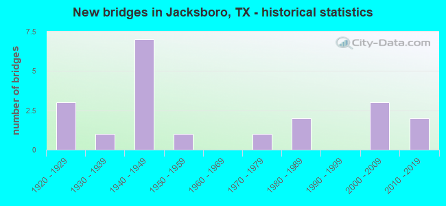
- New bridges - historical statistics
- 31920-1929
- 11930-1939
- 71940-1949
- 11950-1959
- 11970-1979
- 21980-1989
- 32000-2009
- 22010-2019

- Reconstructed bridges - Historical Statistics
- 11930-1939
- 31940-1949
- 11950-1959
- 21960-1969


- Bridge Condition - Deck
- 7.7%Very good
- 46.2%Good
- 46.2%Satisfactory

- Bridge Condition - Superstructure
- 38.5%Very good
- 38.5%Good
- 23.1%Satisfactory

- Bridge Condition - Substructure
- 15.4%Very good
- 53.8%Good
- 30.8%Satisfactory

- Bridge Condition - Channel
- 20.0%Very good
- 30.0%Good
- 35.0%Satisfactory
- 15.0%Fair

- Bridge Condition - Culverts
- 14.3%Good
- 85.7%Satisfactory
Find on map >> Show street view
Structure Number: 21200013404011, Location: 4.6 MI E OF FM-1191 NORTH (Lat: 33.172339, Lng: -98.306303), Route carried "on" structure: US 380, Year Built: 1925, Year Reconstructed: 1943, Status: Open, Structure Length: 0.70m (2.30ft), Average Daily Traffic: 2,256 (year 2020), Truck Traffic: 12%, Average Future Daily Traffic: 4,470 (year 2033), Design Load: H 15, Features Intersected: WEST SALT CREEK
Minimum Vertical Clearance: 30+ m (98+ ft), Kilometerpoint: 11.412, Lanes on structure: 2, Base Highway Network: Yes, Owner: State Highway Agency, Approaching Roadway Width: 11.0m (36.1ft), Material/Design: Concrete, Design/Construction: Culvert, Number Of Spans In Main Unit: 4, Length of Maximum Span: 1.5m (4.9ft), Curb-To-Curb Width: 11.0m (36.1ft), Out-to-Out Width: 14.0m (45.9ft)
Condition: Channel: Fair, Culverts: Satisfactory, Operating Rating: 39.9 metric tons, Method Used To Determine Operating Rating: Load Factor (LF), Inventory Rating: 23.6 metric tons, Method Used To Determine Inventory Rating: Load Factor (LF), Structural Evaluation: Equal to present minimum criteria, Deck Geometry: Somewhat better than minimum adequacy, Waterway Adequacy: Equal to present minimum criteria, Approach Roadway Alignment: Equal to present desirable criteria, Designated Inspection Frequency: Every 24 months, Inspection Date: January 2021, Deck Structure Type: Concrete Cast-file-Place, Wearing Surface/Protective System: Wearing Surface: Bituminous
Find on map >> Show street view
Structure Number: 21200024906039, Location: 1.7 MI SE OF SH-114 (Lat: 33.249472, Lng: -98.240858), Route carried "on" structure: US 281, Year Built: 1942, Year Reconstructed: 1973, Status: Open, Structure Length: 0.79m (2.59ft), Average Daily Traffic: 3,045 (year 2020), Truck Traffic: 18%, Average Future Daily Traffic: 5,180 (year 2033), Design Load: H 15, Features Intersected: PURSLEY BRANCH
Minimum Vertical Clearance: 30+ m (98+ ft), Kilometerpoint: 31.070, Lanes on structure: 4, Base Highway Network: Yes, Owner: State Highway Agency, Approaching Roadway Width: 20.1m (65.9ft), Skew: 20 degrees, Material/Design: Concrete, Design/Construction: Culvert, Number Of Spans In Main Unit: 3, Length of Maximum Span: 2.4m (7.9ft)
Condition: Channel: Good, Culverts: Satisfactory, Operating Rating: 39.9 metric tons, Method Used To Determine Operating Rating: Load Factor (LF), Inventory Rating: 23.6 metric tons, Method Used To Determine Inventory Rating: Load Factor (LF), Structural Evaluation: Equal to present minimum criteria, Waterway Adequacy: Equal to present minimum criteria, Approach Roadway Alignment: Equal to present desirable criteria, Designated Inspection Frequency: Every 24 months, Inspection Date: January 2021
Find on map >> Show street view
Structure Number: 2120002490604, Location: 1.4 MI W OF SH-148 (Lat: 33.229061, Lng: -98.188686), Route carried "on" structure: US 281, Year Built: 1942, Year Reconstructed: 1973, Status: Open, Structure Length: 1.01m (3.31ft), Average Daily Traffic: 3,444 (year 2020), Truck Traffic: 17%, Average Future Daily Traffic: 5,920 (year 2033), Design Load: H 15, Features Intersected: LITTLE CLEVELAND CREEK
Minimum Vertical Clearance: 30+ m (98+ ft), Kilometerpoint: 36.448, Lanes on structure: 5, Base Highway Network: Yes, Owner: State Highway Agency, Approaching Roadway Width: 23.8m (78.1ft), Material/Design: Concrete, Design/Construction: Culvert, Number Of Spans In Main Unit: 3, Length of Maximum Span: 3.0m (9.8ft)
Condition: Channel: Good, Culverts: Satisfactory, Operating Rating: 39.9 metric tons, Method Used To Determine Operating Rating: Load Factor (LF), Inventory Rating: 23.6 metric tons, Method Used To Determine Inventory Rating: Load Factor (LF), Structural Evaluation: Equal to present minimum criteria, Waterway Adequacy: Equal to present minimum criteria, Approach Roadway Alignment: Equal to present desirable criteria, Designated Inspection Frequency: Every 24 months, Inspection Date: January 2021
Find on map >> Show street view
Structure Number: 21200024906066, Location: 3.3 MI W OF SH-148 (Lat: 33.240183, Lng: -98.217353), Route carried "on" structure: US 281, Year Built: 1973, Status: Open, Structure Length: 2.71m (8.89ft), Average Daily Traffic: 1,945 (year 2019), Truck Traffic: 17%, Average Future Daily Traffic: 2,960 (year 2033), Design Load: HS 20, Features Intersected: BIG CLEVELAND CREEK
Minimum Vertical Clearance: 30+ m (98+ ft), Kilometerpoint: 33.450, Lanes on structure: 2, Base Highway Network: Yes, Owner: State Highway Agency, Approaching Roadway Width: 11.3m (37.1ft), Material/Design: Prestressed concrete, Design/Construction: Stringer/Multi-beam, Number Of Spans In Main Unit: 1, Length of Maximum Span: 27.1m (88.9ft), Curb-To-Curb Width: 12.9m (42.3ft), Out-to-Out Width: 13.4m (44.0ft)
Condition: Deck: Good, Superstructure: Good, Substructure: Good, Channel: Very good, Operating Rating: 54.4 metric tons, Method Used To Determine Operating Rating: Assigned rating based on Load Factor Design (LFD) reported in metric tons, Inventory Rating: 32.7 metric tons, Method Used To Determine Inventory Rating: Assigned rating based on Load Factor Design (LFD) reported in metric tons, Structural Evaluation: Better than present minimum criteria, Deck Geometry: Superior to present desirable criteria, Waterway Adequacy: Equal to present minimum criteria, Approach Roadway Alignment: Equal to present desirable criteria, Designated Inspection Frequency: Every 24 months, Inspection Date: January 2021, Deck Structure Type: Concrete Cast-file-Place, Wearing Surface/Protective System: Wearing Surface: Bituminous
Find on map >> Show street view
Structure Number: 21200024906071, Location: 3.3 MI W OF SH-148 (Lat: 33.240381, Lng: -98.217581), Route carried "on" structure: US 281, Year Built: 1989, Status: Open, Structure Length: 3.60m (11.81ft), Average Daily Traffic: 1,969 (year 2019), Truck Traffic: 17%, Average Future Daily Traffic: 2,960 (year 2033), Design Load: HS 20, Features Intersected: BIG CLEVELAND CREEK
Minimum Vertical Clearance: 30+ m (98+ ft), Kilometerpoint: 33.450, Lanes on structure: 2, Base Highway Network: Yes, Owner: State Highway Agency, Approaching Roadway Width: 11.3m (37.1ft), Material/Design: Prestressed concrete, Design/Construction: Stringer/Multi-beam, Number Of Spans In Main Unit: 1, Length of Maximum Span: 36.0m (118.1ft), Curb-To-Curb Width: 11.3m (37.1ft), Out-to-Out Width: 12.2m (40.0ft)
Condition: Deck: Good, Superstructure: Good, Substructure: Good, Channel: Good, Operating Rating: 54.4 metric tons, Method Used To Determine Operating Rating: Assigned rating based on Load Factor Design (LFD) reported in metric tons, Inventory Rating: 32.7 metric tons, Method Used To Determine Inventory Rating: Assigned rating based on Load Factor Design (LFD) reported in metric tons, Structural Evaluation: Better than present minimum criteria, Deck Geometry: Equal to present minimum criteria, Waterway Adequacy: Equal to present minimum criteria, Approach Roadway Alignment: Equal to present desirable criteria, Designated Inspection Frequency: Every 24 months, Inspection Date: January 2021, Deck Structure Type: Concrete Precast Panels, Wearing Surface/Protective System: Wearing Surface: Bituminous
Find on map >> Show street view
Structure Number: 21200024907023, Location: 0.4 MI S OF US-380 WEST (Lat: 33.211783, Lng: -98.158328), Route carried "on" structure: US 281, Year Built: 1925, Year Reconstructed: 1958, Status: Open, Structure Length: 0.70m (2.30ft), Average Daily Traffic: 7,523 (year 2020), Truck Traffic: 15%, Average Future Daily Traffic: 12,500 (year 2037), Design Load: H 15, Features Intersected: ROCK QUARRY/TRIB LOST CK
Minimum Vertical Clearance: 30+ m (98+ ft), Kilometerpoint: 49.025, Lanes on structure: 5, Base Highway Network: Yes, Owner: State Highway Agency, Approaching Roadway Width: 20.7m (67.9ft), Skew: 9 degrees, Material/Design: Concrete, Design/Construction: Culvert, Number Of Spans In Main Unit: 2, Length of Maximum Span: 3.0m (9.8ft)
Condition: Channel: Satisfactory, Culverts: Satisfactory, Operating Rating: 39.9 metric tons, Method Used To Determine Operating Rating: Load Factor (LF), Inventory Rating: 23.6 metric tons, Method Used To Determine Inventory Rating: Load Factor (LF), Structural Evaluation: Somewhat better than minimum adequacy, Waterway Adequacy: Superior to present desirable criteria, Approach Roadway Alignment: Equal to present desirable criteria, Designated Inspection Frequency: Every 24 months, Inspection Date: January 2021
Find on map >> Show street view
Structure Number: 21200024907024, Location: 1.4 MI SE OF FM-3324 (Lat: 33.159208, Lng: -98.099542), Route carried "on" structure: US 281, Year Built: 1925, Year Reconstructed: 1954, Status: Open, Structure Length: 2.01m (6.59ft), Average Daily Traffic: 1,750 (year 2020), Truck Traffic: 28%, Average Future Daily Traffic: 1,720 (year 2033), Design Load: H 15, Features Intersected: CARROLL CREEK
Minimum Vertical Clearance: 30+ m (98+ ft), Kilometerpoint: 57.108, Lanes on structure: 2, Base Highway Network: Yes, Owner: State Highway Agency, Approaching Roadway Width: 11.3m (37.1ft), Material/Design: Concrete, Design/Construction: Tee Beam, Number Of Spans In Main Unit: 2, Length of Maximum Span: 10.1m (33.1ft), Curb-To-Curb Width: 10.4m (34.1ft), Out-to-Out Width: 12.3m (40.4ft)
Condition: Deck: Satisfactory, Superstructure: Satisfactory, Substructure: Satisfactory, Channel: Satisfactory, Operating Rating: 49.0 metric tons, Method Used To Determine Operating Rating: Load Factor (LF), Inventory Rating: 29.0 metric tons, Method Used To Determine Inventory Rating: Load Factor (LF), Structural Evaluation: Equal to present minimum criteria, Deck Geometry: Somewhat better than minimum adequacy, Waterway Adequacy: Equal to present minimum criteria, Approach Roadway Alignment: Equal to present desirable criteria, Designated Inspection Frequency: Every 24 months, Inspection Date: January 2021, Deck Structure Type: Concrete Cast-file-Place, Wearing Surface/Protective System: Wearing Surface: Bituminous
Find on map >> Show street view
Structure Number: 21200024907043, Location: 1.4 MI SE OF FM-3324 (Lat: 33.159228, Lng: -98.099914), Route carried "on" structure: US 281, Year Built: 1958, Status: Open, Structure Length: 3.35m (10.99ft), Average Daily Traffic: 1,760 (year 2020), Truck Traffic: 28%, Average Future Daily Traffic: 1,720 (year 2033), Design Load: H 20, Features Intersected: CARROLL CREEK
Minimum Vertical Clearance: 30+ m (98+ ft), Kilometerpoint: 57.108, Lanes on structure: 2, Base Highway Network: Yes, Owner: State Highway Agency, Approaching Roadway Width: 11.3m (37.1ft), Material/Design: Concrete, Design/Construction: Slab, Number Of Spans In Main Unit: 4, Length of Maximum Span: 9.1m (29.9ft), Curb-To-Curb Width: 10.4m (34.1ft), Out-to-Out Width: 12.3m (40.4ft)
Condition: Deck: Satisfactory, Superstructure: Satisfactory, Substructure: Satisfactory, Channel: Satisfactory, Operating Rating: 49.9 metric tons, Method Used To Determine Operating Rating: Load Factor (LF), Inventory Rating: 29.9 metric tons, Method Used To Determine Inventory Rating: Load Factor (LF), Structural Evaluation: Equal to present minimum criteria, Deck Geometry: Somewhat better than minimum adequacy, Waterway Adequacy: Equal to present minimum criteria, Approach Roadway Alignment: Equal to present desirable criteria, Designated Inspection Frequency: Every 24 months, Inspection Date: January 2021, Deck Structure Type: Concrete Cast-file-Place, Wearing Surface/Protective System: Wearing Surface: Bituminous
Find on map >> Show street view
Structure Number: 21200024907121, Location: 0.3 MI S OF US 380 WEST (Lat: 33.214189, Lng: -98.158569), Route carried "on" structure: US 281, Year Built: 2013, Status: Open, Structure Length: 3.47m (11.38ft), Average Daily Traffic: 7,523 (year 2020), Truck Traffic: 15%, Average Future Daily Traffic: 12,500 (year 2037), Design Load: HL 93, Features Intersected: LOST CREEK
Minimum Vertical Clearance: 30+ m (98+ ft), Kilometerpoint: 48.713, Lanes on structure: 5, Owner: State Highway Agency, Approaching Roadway Width: 20.1m (65.9ft), Material/Design: Prestressed concrete, Design/Construction: Stringer/Multi-beam, Number Of Spans In Main Unit: 1, Length of Maximum Span: 34.7m (113.8ft), Curb or Sidewalk Widths: Left: 1.5m (4.9ft), Right: 1.5m (4.9ft), Curb-To-Curb Width: 20.1m (65.9ft), Out-to-Out Width: 24.4m (80.1ft)
Condition: Deck: Good, Superstructure: Very good, Substructure: Very good, Channel: Very good, Operating Rating: 54.4 metric tons, Method Used To Determine Operating Rating: Assigned ratings based on Load and Resistance Factor Design (LRFD) reported in metric tons, Inventory Rating: 32.7 metric tons, Method Used To Determine Inventory Rating: Assigned ratings based on Load and Resistance Factor Design (LRFD) reported in metric tons, Structural Evaluation: Equal to present desirable criteria, Deck Geometry: Somewhat better than minimum adequacy, Waterway Adequacy: Superior to present desirable criteria, Approach Roadway Alignment: Equal to present desirable criteria, Designated Inspection Frequency: Every 24 months, Inspection Date: January 2021, Deck Structure Type: Concrete Precast Panels
Find on map >> Show street view
Structure Number: 21200039106005, Location: 0.3 MI S OF FM-2190 (Lat: 33.291308, Lng: -98.182725), Route carried "on" structure: State highway 148, Year Built: 2005, Status: Open, Structure Length: 5.67m (18.60ft), Average Daily Traffic: 600 (year 2020), Truck Traffic: 42%, Average Future Daily Traffic: 770 (year 2037), Design Load: HS 20, Features Intersected: NORTH CREEK NORTH RELIEF
Minimum Vertical Clearance: 30+ m (98+ ft), Kilometerpoint: 21.539, Lanes on structure: 2, Base Highway Network: Yes, Owner: State Highway Agency, Approaching Roadway Width: 12.2m (40.0ft), Material/Design: Prestressed concrete, Design/Construction: Stringer/Multi-beam, Number Of Spans In Main Unit: 3, Length of Maximum Span: 22.6m (74.1ft), Curb-To-Curb Width: 11.9m (39.0ft), Out-to-Out Width: 12.8m (42.0ft)
Condition: Deck: Good, Superstructure: Very good, Substructure: Good, Channel: Good, Operating Rating: 54.4 metric tons, Method Used To Determine Operating Rating: Assigned rating based on Load Factor Design (LFD) reported in metric tons, Inventory Rating: 32.7 metric tons, Method Used To Determine Inventory Rating: Assigned rating based on Load Factor Design (LFD) reported in metric tons, Structural Evaluation: Better than present minimum criteria, Deck Geometry: Better than present minimum criteria, Waterway Adequacy: Superior to present desirable criteria, Approach Roadway Alignment: Equal to present desirable criteria, Designated Inspection Frequency: Every 24 months, Inspection Date: January 2021, Deck Structure Type: Concrete Cast-file-Place
Find on map >> Show street view
Structure Number: 21200039106012, Location: 0.5 MI S OF FM-2190 (Lat: 33.288778, Lng: -98.181714), Route carried "on" structure: State highway 148, Year Built: 2005, Status: Open, Structure Length: 4.39m (14.40ft), Average Daily Traffic: 600 (year 2020), Truck Traffic: 42%, Average Future Daily Traffic: 770 (year 2037), Design Load: HS 20, Features Intersected: NORTH CREEK SOUTH RELIEF
Minimum Vertical Clearance: 30+ m (98+ ft), Kilometerpoint: 21.884, Lanes on structure: 2, Base Highway Network: Yes, Owner: State Highway Agency, Approaching Roadway Width: 11.9m (39.0ft), Material/Design: Prestressed concrete, Design/Construction: Stringer/Multi-beam, Number Of Spans In Main Unit: 2, Length of Maximum Span: 23.5m (77.1ft), Curb-To-Curb Width: 11.9m (39.0ft), Out-to-Out Width: 12.8m (42.0ft)
Condition: Deck: Good, Superstructure: Very good, Substructure: Good, Channel: Very good, Operating Rating: 54.4 metric tons, Method Used To Determine Operating Rating: Assigned rating based on Load Factor Design (LFD) reported in metric tons, Inventory Rating: 32.7 metric tons, Method Used To Determine Inventory Rating: Assigned rating based on Load Factor Design (LFD) reported in metric tons, Structural Evaluation: Better than present minimum criteria, Deck Geometry: Better than present minimum criteria, Waterway Adequacy: Superior to present desirable criteria, Approach Roadway Alignment: Equal to present desirable criteria, Designated Inspection Frequency: Every 24 months, Inspection Date: January 2021, Deck Structure Type: Concrete Cast-file-Place
Find on map >> Show street view
Structure Number: 21200039106025, Location: 1.8 MI S OF FM-2190 (Lat: 33.268914, Lng: -98.174594), Route carried "on" structure: State highway 148, Year Built: 1942, Year Reconstructed: 1946, Status: Open, Structure Length: 1.19m (3.90ft), Average Daily Traffic: 1,284 (year 2019), Truck Traffic: 25%, Average Future Daily Traffic: 2,050 (year 2037), Design Load: H 15, Features Intersected: CLEVELAND BRANCH
Minimum Vertical Clearance: 30+ m (98+ ft), Kilometerpoint: 24.168, Lanes on structure: 2, Base Highway Network: Yes, Owner: State Highway Agency, Approaching Roadway Width: 10.4m (34.1ft), Material/Design: Concrete, Design/Construction: Culvert, Number Of Spans In Main Unit: 5, Length of Maximum Span: 2.1m (6.9ft)
Condition: Channel: Satisfactory, Culverts: Satisfactory, Operating Rating: 39.9 metric tons, Method Used To Determine Operating Rating: Load Factor (LF), Inventory Rating: 23.6 metric tons, Method Used To Determine Inventory Rating: Load Factor (LF), Structural Evaluation: Equal to present minimum criteria, Waterway Adequacy: Equal to present minimum criteria, Approach Roadway Alignment: Equal to present desirable criteria, Designated Inspection Frequency: Every 24 months, Inspection Date: January 2021
Find on map >> Show street view
Structure Number: 21200039106026, Location: 1.9 MI SOF FM-2190 (Lat: 33.267658, Lng: -98.174256), Route carried "on" structure: State highway 148, Year Built: 1942, Year Reconstructed: 1946, Status: Open, Structure Length: 0.98m (3.22ft), Average Daily Traffic: 1,284 (year 2019), Truck Traffic: 25%, Average Future Daily Traffic: 2,050 (year 2037), Design Load: H 15, Features Intersected: LITTLE CLEVELAND CREEK
Minimum Vertical Clearance: 30+ m (98+ ft), Kilometerpoint: 24.312, Lanes on structure: 2, Base Highway Network: Yes, Owner: State Highway Agency, Approaching Roadway Width: 10.4m (34.1ft), Material/Design: Concrete, Design/Construction: Culvert, Number Of Spans In Main Unit: 4, Length of Maximum Span: 2.1m (6.9ft)
Condition: Channel: Fair, Culverts: Satisfactory, Operating Rating: 39.9 metric tons, Method Used To Determine Operating Rating: Load Factor (LF), Inventory Rating: 23.6 metric tons, Method Used To Determine Inventory Rating: Load Factor (LF), Structural Evaluation: Equal to present minimum criteria, Waterway Adequacy: Equal to present minimum criteria, Approach Roadway Alignment: Equal to present desirable criteria, Designated Inspection Frequency: Every 24 months, Inspection Date: January 2021
Find on map >> Show street view
Structure Number: 21200039106028, Location: 0.7 MI S OF FM-2190 (Lat: 33.284792, Lng: -98.180128), Route carried "on" structure: State highway 148, Year Built: 2005, Status: Open, Structure Length: 4.63m (15.19ft), Average Daily Traffic: 600 (year 2020), Truck Traffic: 42%, Average Future Daily Traffic: 770 (year 2037), Design Load: HS 20, Features Intersected: NORTH CREEK
Minimum Vertical Clearance: 30+ m (98+ ft), Kilometerpoint: 22.296, Lanes on structure: 2, Base Highway Network: Yes, Owner: State Highway Agency, Approaching Roadway Width: 10.7m (35.1ft), Skew: 4 degrees, Material/Design: Prestressed concrete, Design/Construction: Stringer/Multi-beam, Number Of Spans In Main Unit: 2, Length of Maximum Span: 23.2m (76.1ft), Curb-To-Curb Width: 11.9m (39.0ft), Out-to-Out Width: 12.8m (42.0ft)
Condition: Deck: Good, Superstructure: Very good, Substructure: Good, Channel: Very good, Operating Rating: 54.4 metric tons, Method Used To Determine Operating Rating: Assigned rating based on Load Factor Design (LFD) reported in metric tons, Inventory Rating: 32.7 metric tons, Method Used To Determine Inventory Rating: Assigned rating based on Load Factor Design (LFD) reported in metric tons, Structural Evaluation: Better than present minimum criteria, Deck Geometry: Better than present minimum criteria, Waterway Adequacy: Superior to present desirable criteria, Approach Roadway Alignment: Equal to present desirable criteria, Designated Inspection Frequency: Every 24 months, Inspection Date: January 2021, Deck Structure Type: Concrete Cast-file-Place
Find on map >> Show street view
Structure Number: 21200039107063, Location: .75 MI S OF US 380 (Lat: 33.195936, Lng: -98.189642), Route carried "on" structure: State highway 4, Year Built: 1936, Status: Open, Structure Length: 1.01m (3.31ft), Average Daily Traffic: 617 (year 2020), Truck Traffic: 14%, Average Future Daily Traffic: 1,720 (year 2033), Features Intersected: SPILLERS BRANCH
Minimum Vertical Clearance: 30+ m (98+ ft), Kilometerpoint: 2.960, Lanes on structure: 2, Base Highway Network: Yes, Owner: State Highway Agency, Approaching Roadway Width: 7.3m (24.0ft), Skew: 4 degrees, Material/Design: Masonry, Design/Construction: Culvert, Number Of Spans In Main Unit: 2, Length of Maximum Span: 4.9m (16.1ft), Curb-To-Curb Width: 7.3m (24.0ft), Out-to-Out Width: 7.7m (25.3ft)
Condition: Channel: Satisfactory, Culverts: Good, Operating Rating: 32.7 metric tons, Method Used To Determine Operating Rating: Field evaluation and documented engineering judgment, Inventory Rating: 24.5 metric tons, Method Used To Determine Inventory Rating: Field evaluation and documented engineering judgment, Structural Evaluation: Equal to present minimum criteria, Deck Geometry: Meets minimum limits, Waterway Adequacy: Equal to present minimum criteria, Approach Roadway Alignment: Equal to present desirable criteria, Length Of Structure Improvement: 1.01m (3.31ft), Designated Inspection Frequency: Every 24 months, Inspection Date: January 2021, Bridge Improvement Cost: $2,000, Roadway Improvement Cost: $1,000, Total Project Cost: $3,000, Deck Structure Type: Concrete Cast-file-Place, Wearing Surface/Protective System: Wearing Surface: Bituminous
Find on map >> Show street view
Structure Number: 21200AA0134001, Location: 5.4 MI N FROM SH 199 (Lat: 33.300022, Lng: -98.153386), Route carried "on" structure: County highway 134, Year Built: 1987, Status: Open, Structure Length: 1.10m (3.61ft), Average Daily Traffic: 100 (year 2019), Average Future Daily Traffic: 100 (year 2029), Features Intersected: BIG CLEVELAND CREEK, Facility Carried by Structure: POSTOAK RD - PCT 1
Minimum Vertical Clearance: 30+ m (98+ ft), Kilometerpoint: 8.690, Lanes on structure: 2, Owner: County Highway Agency, Approaching Roadway Width: 6.1m (20.0ft), Material/Design: Steel continuous, Design/Construction: Stringer/Multi-beam, Number Of Spans In Main Unit: 2, Length of Maximum Span: 6.1m (20.0ft), Curb-To-Curb Width: 6.4m (21.0ft), Out-to-Out Width: 6.4m (21.0ft)
Condition: Deck: Satisfactory, Superstructure: Good, Substructure: Satisfactory, Channel: Satisfactory, Operating Rating: 58.0 metric tons, Method Used To Determine Operating Rating: Allowable Stress (AS), Inventory Rating: 40.8 metric tons, Method Used To Determine Inventory Rating: Allowable Stress (AS), Structural Evaluation: Equal to present minimum criteria, Deck Geometry: Somewhat better than minimum adequacy, Waterway Adequacy: Better than present minimum criteria, Approach Roadway Alignment: Equal to present desirable criteria, Designated Inspection Frequency: Every 24 months, Critical Feature Inspection Frequency: Every 24 months, Inspection Date: January 2021, Critical Feature Inspection Date: January 2020, Deck Structure Type: Concrete Cast-file-Place, Wearing Surface/Protective System: Wearing Surface: Gravel
Find on map >> Show street view
Structure Number: 21200AA0160001, Location: 1.8 MI NW OF US-281 (Lat: 33.251108, Lng: -98.212289), Route carried "on" structure: County highway , Year Built: 1941, Status: Posted for load, Structure Length: 1.22m (4.00ft), Average Daily Traffic: 50 (year 2011), Average Future Daily Traffic: 100 (year 2031), Features Intersected: BIG CLEVELAND CREEK, Facility Carried by Structure: LOWRANCE RD -PCT 4
Minimum Vertical Clearance: 30+ m (98+ ft), Kilometerpoint: 3.219, Lanes on structure: 1, Owner: County Highway Agency, Approaching Roadway Width: 3.7m (12.1ft), Material/Design: Steel, Design/Construction: Stringer/Multi-beam, Number Of Spans In Main Unit: 1, Length of Maximum Span: 11.3m (37.1ft), Curb-To-Curb Width: 4.1m (13.5ft), Out-to-Out Width: 4.1m (13.5ft)
Condition: Deck: Satisfactory, Superstructure: Satisfactory, Substructure: Satisfactory, Channel: Fair, Operating Rating: 27.2 metric tons, Method Used To Determine Operating Rating: Allowable Stress (AS), Inventory Rating: 18.1 metric tons, Method Used To Determine Inventory Rating: Allowable Stress (AS), Structural Evaluation: Somewhat better than minimum adequacy, Deck Geometry: Somewhat better than minimum adequacy, Waterway Adequacy: Equal to present minimum criteria, Approach Roadway Alignment: Equal to present desirable criteria, Bridge Posting: Required (Relationship of Operating Rating to Maximum Legal Load: 10.0 - 19.9% below), Designated Inspection Frequency: Every 24 months, Inspection Date: January 2021, Deck Structure Type: Concrete Cast-file-Place
Find on map >> Show street view
Structure Number: 21200AA0164001, Location: 1.3 MI S OF FM-2190 (Lat: 33.279344, Lng: -98.198494), Route carried "on" structure: County highway , Year Built: 1946, Status: Open, Structure Length: 0.98m (3.22ft), Average Daily Traffic: 100 (year 2019), Average Future Daily Traffic: 100 (year 2029), Features Intersected: BIG CLEVELAND CREEK, Facility Carried by Structure: ROGERS RD PCT 4
Minimum Vertical Clearance: 30+ m (98+ ft), Kilometerpoint: 0.772, Lanes on structure: 1, Owner: County Highway Agency, Approaching Roadway Width: 4.9m (16.1ft), Material/Design: Steel, Design/Construction: Stringer/Multi-beam, Number Of Spans In Main Unit: 1, Length of Maximum Span: 9.4m (30.8ft), Curb-To-Curb Width: 4.3m (14.1ft), Out-to-Out Width: 4.3m (14.1ft)
Condition: Deck: Satisfactory, Superstructure: Good, Substructure: Good, Channel: Good, Operating Rating: 64.4 metric tons, Method Used To Determine Operating Rating: Allowable Stress (AS), Inventory Rating: 40.8 metric tons, Method Used To Determine Inventory Rating: Allowable Stress (AS), Structural Evaluation: Better than present minimum criteria, Deck Geometry: Equal to present minimum criteria, Waterway Adequacy: Better than present minimum criteria, Approach Roadway Alignment: Equal to present minimum criteria, Length Of Structure Improvement: 0.98m (3.22ft), Designated Inspection Frequency: Every 24 months, Inspection Date: January 2021, Total Project Cost: $9,000, Deck Structure Type: Concrete Cast-file-Place
Find on map >> Show street view
Structure Number: 21200AA0164002, Location: 0.70 MI S OF FM 2190 (Lat: 33.285406, Lng: -98.202989), Route carried "on" structure: County highway , Year Built: 1945, Status: Open, Structure Length: 1.13m (3.71ft), Average Daily Traffic: 100 (year 2019), Average Future Daily Traffic: 100 (year 2029), Features Intersected: NORTH CREEK, Facility Carried by Structure: ROGERS RD PCT 4
Minimum Vertical Clearance: 30+ m (98+ ft), Kilometerpoint: 1.770, Lanes on structure: 1, Owner: County Highway Agency, Approaching Roadway Width: 4.3m (14.1ft), Material/Design: Steel, Design/Construction: Stringer/Multi-beam, Number Of Spans In Main Unit: 1, Length of Maximum Span: 11.3m (37.1ft), Curb-To-Curb Width: 4.3m (14.1ft), Out-to-Out Width: 4.3m (14.1ft)
Condition: Deck: Satisfactory, Superstructure: Good, Substructure: Good, Channel: Satisfactory, Operating Rating: 56.2 metric tons, Method Used To Determine Operating Rating: Load Factor (LF), Inventory Rating: 33.6 metric tons, Method Used To Determine Inventory Rating: Load Factor (LF), Structural Evaluation: Better than present minimum criteria, Deck Geometry: Equal to present minimum criteria, Waterway Adequacy: Better than present minimum criteria, Approach Roadway Alignment: Equal to present minimum criteria, Length Of Structure Improvement: 1.13m (3.71ft), Designated Inspection Frequency: Every 24 months, Inspection Date: January 2021, Total Project Cost: $10,000, Deck Structure Type: Concrete Cast-file-Place
Find on map >> Show street view
Structure Number: 21200AA0168002, Location: 1.9 Mi. S. of US 281 (Lat: 33.222500, Lng: -98.236100), Route carried "on" structure: County highway , Year Built: 2015, Status: Open, Structure Length: 1.46m (4.79ft), Average Daily Traffic: 122 (year 2014), Average Future Daily Traffic: 120 (year 2034), Design Load: HL 93, Features Intersected: Big Cleveland Creek, Facility Carried by Structure: Burwick Rd. Pct. 4
Minimum Vertical Clearance: 30+ m (98+ ft), Kilometerpoint: 5.794, Lanes on structure: 2, Owner: County Highway Agency, Approaching Roadway Width: 5.5m (18.0ft), Skew: 1 degrees, Material/Design: Prestressed concrete, Design/Construction: Stringer/Multi-beam, Number Of Spans In Main Unit: 1, Length of Maximum Span: 14.6m (47.9ft), Curb-To-Curb Width: 7.2m (23.6ft), Out-to-Out Width: 7.9m (25.9ft)
Condition: Deck: Very good, Superstructure: Very good, Substructure: Very good, Channel: Good, Operating Rating: 54.4 metric tons, Method Used To Determine Operating Rating: Assigned ratings based on Load and Resistance Factor Design (LRFD) reported in metric tons, Inventory Rating: 32.7 metric tons, Method Used To Determine Inventory Rating: Assigned ratings based on Load and Resistance Factor Design (LRFD) reported in metric tons, Structural Evaluation: Equal to present desirable criteria, Deck Geometry: Meets minimum limits, Waterway Adequacy: Better than present minimum criteria, Approach Roadway Alignment: Equal to present desirable criteria, Designated Inspection Frequency: Every 24 months, Inspection Date: January 2021, Deck Structure Type: Concrete Precast Panels, Wearing Surface/Protective System: Deck Protection: Epoxy Coated Reinforcing