Bridge Statistics for James Town, Wyoming (WY)
Condition, Traffic, Stress, Structural Evaluation, Project Costs
- National Bridge Inventory (NBI) Statistics
- 16Number of bridges
- 253ft / 77.1mTotal length
- $334,000Total costs
- 92,338Total average daily traffic
- 41,368Total average daily truck traffic
- National Bridge Inventory (NBI) Registered Bridges for James Town
- No street view available for this location
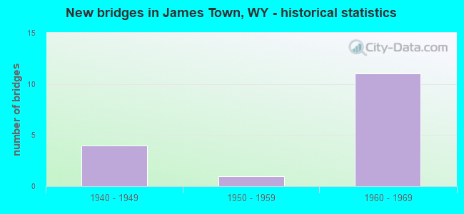
- New bridges - historical statistics
- 41940-1949
- 11950-1959
- 111960-1969


- Bridge Condition - Deck
- 33.3%Good
- 33.3%Satisfactory
- 16.7%Fair
- 16.7%Poor

- Bridge Condition - Superstructure
- 50.0%Good
- 41.7%Satisfactory
- 8.3%Fair

- Bridge Condition - Substructure
- 75.0%Good
- 25.0%Satisfactory

- Bridge Condition - Channel
- 16.7%Very good
- 50.0%Good
- 33.3%Satisfactory

- Bridge Condition - Culverts
- 50.0%Satisfactory
- 50.0%Poor
Find on map >> Show street view
Structure Number: AOV, Location: Granger Jct - Green River (Lat: 41.549608, Lng: -109.601878), Route carried "on" structure: Interstate 80, Year Built: 1966, Status: Open, Structure Length: 7.56m (24.80ft), Average Daily Traffic: 7,886 (year 2021), Truck Traffic: 44%, Average Future Daily Traffic: 11,040 (year 2041), Design Load: HS 20+Mod, Features Intersected: UPRR
Minimum Vertical Clearance: 30+ m (98+ ft), Kilometerpoint: 132.509, Lanes on structure: 2, Base Highway Network: Yes (Inventory Route: ML8, Subroute: 1), Owner: State Highway Agency, Approaching Roadway Width: 11.6m (38.1ft), Skew: 14 degrees, Material/Design: Steel continuous, Design/Construction: Stringer/Multi-beam, Number Of Spans In Main Unit: 3, Length of Maximum Span: 34.1m (111.9ft), Curb-To-Curb Width: 11.6m (38.1ft), Out-to-Out Width: 12.4m (40.7ft)
Condition: Deck: Satisfactory, Superstructure: Satisfactory, Substructure: Good, Operating Rating: 54.4 metric tons, Method Used To Determine Operating Rating: Load Factor (LF), Inventory Rating: 32.7 metric tons, Method Used To Determine Inventory Rating: Load Factor (LF), Structural Evaluation: Equal to present minimum criteria, Deck Geometry: Equal to present minimum criteria, Underclear: Equal to present minimum criteria, Approach Roadway Alignment: Equal to present desirable criteria, Designated Inspection Frequency: Every 24 months, Inspection Date: June 2021, Deck Structure Type: Concrete Cast-file-Place, Wearing Surface/Protective System: Wearing Surface: Latex Concrete
Find on map >> Show street view
Structure Number: AOW, Location: Granger Jct - Green River (Lat: 41.549644, Lng: -109.602753), Route carried "on" structure: Interstate 80, Year Built: 1966, Status: Open, Structure Length: 7.56m (24.80ft), Average Daily Traffic: 7,816 (year 2021), Truck Traffic: 44%, Average Future Daily Traffic: 10,942 (year 2041), Design Load: HS 20+Mod, Features Intersected: UPRR
Minimum Vertical Clearance: 30+ m (98+ ft), Kilometerpoint: 132.224, Lanes on structure: 2, Base Highway Network: Yes (Inventory Route: ML8, Subroute: 1), Owner: State Highway Agency, Approaching Roadway Width: 11.6m (38.1ft), Skew: 14 degrees, Material/Design: Steel continuous, Design/Construction: Stringer/Multi-beam, Number Of Spans In Main Unit: 3, Length of Maximum Span: 34.1m (111.9ft), Curb-To-Curb Width: 11.6m (38.1ft), Out-to-Out Width: 12.4m (40.7ft)
Condition: Deck: Satisfactory, Superstructure: Satisfactory, Substructure: Satisfactory, Operating Rating: 54.4 metric tons, Method Used To Determine Operating Rating: Load Factor (LF), Inventory Rating: 32.7 metric tons, Method Used To Determine Inventory Rating: Load Factor (LF), Structural Evaluation: Equal to present minimum criteria, Deck Geometry: Equal to present minimum criteria, Underclear: Somewhat better than minimum adequacy, Approach Roadway Alignment: Equal to present desirable criteria, Designated Inspection Frequency: Every 24 months, Inspection Date: June 2021, Deck Structure Type: Concrete Cast-file-Place, Wearing Surface/Protective System: Wearing Surface: Latex Concrete
Find on map >> Show street view
Structure Number: AOX, Location: Granger Jct - Green River (Lat: 41.562086, Lng: -109.541878), Route carried "on" structure: Interstate 80, Year Built: 1966, Status: Open, Structure Length: 2.80m (9.19ft), Average Daily Traffic: 8,804 (year 2021), Truck Traffic: 89%, Average Future Daily Traffic: 12,326 (year 2041), Design Load: HS 20+Mod, Features Intersected: Sw CR 59 / Gaensslen Rd
Minimum Vertical Clearance: 30+ m (98+ ft), Kilometerpoint: 137.945, Lanes on structure: 2, Lanes under structure: 2, Base Highway Network: Yes (Inventory Route: ML8, Subroute: 1), Owner: State Highway Agency, Approaching Roadway Width: 11.6m (38.1ft), Skew: 10 degrees, Material/Design: Concrete continuous, Design/Construction: Tee Beam, Number Of Spans In Main Unit: 3, Length of Maximum Span: 11.3m (37.1ft), Curb-To-Curb Width: 11.6m (38.1ft), Out-to-Out Width: 12.4m (40.7ft)
Condition: Deck: Good, Superstructure: Good, Substructure: Good, Operating Rating: 40.5 metric tons, Method Used To Determine Operating Rating: Load Factor (LF), Inventory Rating: 24.3 metric tons, Method Used To Determine Inventory Rating: Load Factor (LF), Structural Evaluation: Equal to present minimum criteria, Deck Geometry: Equal to present minimum criteria, Underclear: Meets minimum limits, Approach Roadway Alignment: Equal to present desirable criteria, Designated Inspection Frequency: Every 24 months, Inspection Date: June 2021, Deck Structure Type: Concrete Cast-file-Place, Wearing Surface/Protective System: Wearing Surface: Latex Concrete
Find on map >> Show street view
Structure Number: AOY, Location: Granger Jct - Green River (Lat: 41.562278, Lng: -109.541767), Route carried "on" structure: Interstate 80, Year Built: 1966, Status: Open, Structure Length: 2.80m (9.19ft), Average Daily Traffic: 8,721 (year 2021), Truck Traffic: 44%, Average Future Daily Traffic: 12,209 (year 2041), Design Load: HS 20+Mod, Features Intersected: Sw CR 59 / Gaensslen Rd
Minimum Vertical Clearance: 30+ m (98+ ft), Kilometerpoint: 137.745, Lanes on structure: 2, Lanes under structure: 2, Base Highway Network: Yes (Inventory Route: ML8, Subroute: 1), Owner: State Highway Agency, Approaching Roadway Width: 11.6m (38.1ft), Skew: 10 degrees, Material/Design: Concrete continuous, Design/Construction: Tee Beam, Number Of Spans In Main Unit: 3, Length of Maximum Span: 11.3m (37.1ft), Curb-To-Curb Width: 11.6m (38.1ft), Out-to-Out Width: 12.4m (40.7ft)
Condition: Deck: Satisfactory, Superstructure: Good, Substructure: Good, Operating Rating: 40.5 metric tons, Method Used To Determine Operating Rating: Load Factor (LF), Inventory Rating: 24.3 metric tons, Method Used To Determine Inventory Rating: Load Factor (LF), Structural Evaluation: Equal to present minimum criteria, Deck Geometry: Equal to present minimum criteria, Underclear: Meets minimum limits, Approach Roadway Alignment: Equal to present desirable criteria, Designated Inspection Frequency: Every 24 months, Inspection Date: June 2021, Deck Structure Type: Concrete Cast-file-Place, Wearing Surface/Protective System: Wearing Surface: Epoxy Overlay
Find on map >> Show street view
Structure Number: AOZ, Location: Granger Jct - Green River (Lat: 41.559914, Lng: -109.529439), Route carried "on" structure: Interstate 80, Year Built: 1966, Year Reconstructed: 1986, Status: Open, Structure Length: 9.91m (32.51ft), Average Daily Traffic: 8,350 (year 2021), Truck Traffic: 45%, Average Future Daily Traffic: 11,690 (year 2041), Design Load: HS 20+Mod, Features Intersected: Green River
Minimum Vertical Clearance: 30+ m (98+ ft), Kilometerpoint: 139.015, Lanes on structure: 2, Base Highway Network: Yes (Inventory Route: ML8, Subroute: 1), Owner: State Highway Agency, Approaching Roadway Width: 11.6m (38.1ft), Skew: 13 degrees, Material/Design: Steel continuous, Design/Construction: Stringer/Multi-beam, Number Of Spans In Main Unit: 4, Length of Maximum Span: 26.5m (86.9ft), Curb-To-Curb Width: 12.8m (42.0ft), Out-to-Out Width: 13.6m (44.6ft)
Condition: Deck: Good, Superstructure: Good, Substructure: Good, Channel: Good, Operating Rating: 55.3 metric tons, Method Used To Determine Operating Rating: Load Factor (LF), Inventory Rating: 32.7 metric tons, Method Used To Determine Inventory Rating: Load Factor (LF), Structural Evaluation: Better than present minimum criteria, Deck Geometry: Equal to present desirable criteria, Waterway Adequacy: Equal to present desirable criteria, Approach Roadway Alignment: Equal to present desirable criteria, Designated Inspection Frequency: Every 24 months, Underwater Inspection Frequency: Every 60 months, Inspection Date: June 2021, Underwater Inspection Date: August 2019, Deck Structure Type: Concrete Cast-file-Place, Wearing Surface/Protective System: Wearing Surface: Latex Concrete, Deck Protection: Epoxy Coated Reinforcing
Find on map >> Show street view
Structure Number: APA, Location: Granger Jct - Green River (Lat: 41.560122, Lng: -109.529544), Route carried "on" structure: Interstate 80, Year Built: 1966, Year Reconstructed: 1986, Status: Open, Structure Length: 9.89m (32.45ft), Average Daily Traffic: 8,721 (year 2021), Truck Traffic: 44%, Average Future Daily Traffic: 12,209 (year 2041), Design Load: HS 20+Mod, Features Intersected: Green River
Minimum Vertical Clearance: 30+ m (98+ ft), Kilometerpoint: 138.798, Lanes on structure: 2, Base Highway Network: Yes (Inventory Route: ML8, Subroute: 1), Owner: State Highway Agency, Approaching Roadway Width: 12.8m (42.0ft), Skew: 13 degrees, Material/Design: Steel continuous, Design/Construction: Stringer/Multi-beam, Number Of Spans In Main Unit: 4, Length of Maximum Span: 26.5m (86.9ft), Curb-To-Curb Width: 12.8m (42.0ft), Out-to-Out Width: 13.6m (44.6ft)
Condition: Deck: Satisfactory, Superstructure: Good, Substructure: Good, Channel: Good, Operating Rating: 55.3 metric tons, Method Used To Determine Operating Rating: Load Factor (LF), Inventory Rating: 32.7 metric tons, Method Used To Determine Inventory Rating: Load Factor (LF), Structural Evaluation: Better than present minimum criteria, Deck Geometry: Equal to present desirable criteria, Waterway Adequacy: Equal to present desirable criteria, Approach Roadway Alignment: Equal to present desirable criteria, Designated Inspection Frequency: Every 24 months, Underwater Inspection Frequency: Every 60 months, Inspection Date: June 2021, Underwater Inspection Date: August 2019, Deck Structure Type: Concrete Cast-file-Place, Wearing Surface/Protective System: Wearing Surface: Latex Concrete
Find on map >> Show street view
Structure Number: APB, Location: Granger Jct - Green River (Lat: 41.554853, Lng: -109.509689), Route carried "on" structure: Interstate 80, Year Built: 1966, Status: Open, Structure Length: 2.80m (9.19ft), Average Daily Traffic: 8,350 (year 2021), Truck Traffic: 45%, Average Future Daily Traffic: 11,690 (year 2041), Design Load: HS 20+Mod, Features Intersected: Sw CR 5 / Blue Rim Rd
Minimum Vertical Clearance: 30+ m (98+ ft), Kilometerpoint: 140.779, Lanes on structure: 2, Lanes under structure: 2, Base Highway Network: Yes (Inventory Route: ML8, Subroute: 1), Owner: State Highway Agency, Approaching Roadway Width: 11.6m (38.1ft), Skew: 10 degrees, Material/Design: Concrete continuous, Design/Construction: Tee Beam, Number Of Spans In Main Unit: 3, Length of Maximum Span: 11.3m (37.1ft), Curb-To-Curb Width: 11.6m (38.1ft), Out-to-Out Width: 12.4m (40.7ft)
Condition: Deck: Good, Superstructure: Good, Substructure: Good, Operating Rating: 43.2 metric tons, Method Used To Determine Operating Rating: Load Factor (LF), Inventory Rating: 25.2 metric tons, Method Used To Determine Inventory Rating: Load Factor (LF), Structural Evaluation: Equal to present minimum criteria, Deck Geometry: Equal to present minimum criteria, Underclear: Meets minimum limits, Approach Roadway Alignment: Equal to present desirable criteria, Designated Inspection Frequency: Every 24 months, Inspection Date: June 2021, Deck Structure Type: Concrete Cast-file-Place, Wearing Surface/Protective System: Wearing Surface: Latex Concrete
Find on map >> Show street view
Structure Number: APC, Location: Granger Jct - Green River (Lat: 41.555003, Lng: -109.509658), Route carried "on" structure: Interstate 80, Year Built: 1966, Status: Open, Structure Length: 2.80m (9.19ft), Average Daily Traffic: 8,662 (year 2021), Truck Traffic: 44%, Average Future Daily Traffic: 12,127 (year 2041), Design Load: HS 20+Mod, Features Intersected: Sw CR 5 / Blue Rim Rd
Minimum Vertical Clearance: 30+ m (98+ ft), Kilometerpoint: 140.575, Lanes on structure: 2, Lanes under structure: 2, Base Highway Network: Yes (Inventory Route: ML8, Subroute: 1), Owner: State Highway Agency, Approaching Roadway Width: 11.6m (38.1ft), Skew: 10 degrees, Material/Design: Concrete continuous, Design/Construction: Tee Beam, Number Of Spans In Main Unit: 3, Length of Maximum Span: 11.3m (37.1ft), Curb-To-Curb Width: 11.6m (38.1ft), Out-to-Out Width: 12.4m (40.7ft)
Condition: Deck: Good, Superstructure: Good, Substructure: Good, Operating Rating: 43.2 metric tons, Method Used To Determine Operating Rating: Load Factor (LF), Inventory Rating: 25.2 metric tons, Method Used To Determine Inventory Rating: Load Factor (LF), Structural Evaluation: Equal to present minimum criteria, Deck Geometry: Equal to present minimum criteria, Underclear: Meets minimum limits, Approach Roadway Alignment: Equal to present desirable criteria, Length Of Structure Improvement: 1.07m (3.51ft), Designated Inspection Frequency: Every 24 months, Inspection Date: June 2021, Bridge Improvement Cost: $10,000, Roadway Improvement Cost: $1,000, Total Project Cost: $15,000, Deck Structure Type: Concrete Cast-file-Place, Wearing Surface/Protective System: Wearing Surface: Latex Concrete
Find on map >> Show street view
Structure Number: BKD, Location: Jct I-80 - Green River (Lat: 41.549981, Lng: -109.606981), Route carried "on" structure: State highway 374, Year Built: 1946, Status: Open, Structure Length: 10.41m (34.15ft), Average Daily Traffic: 1,085 (year 2021), Truck Traffic: 10%, Average Future Daily Traffic: 1,519 (year 2041), Design Load: HS 20, Features Intersected: UPRR
Minimum Vertical Clearance: 30+ m (98+ ft), Kilometerpoint: 132.927, Lanes on structure: 2, Owner: State Highway Agency, Approaching Roadway Width: 8.8m (28.9ft), Material/Design: Steel continuous, Design/Construction: Stringer/Multi-beam, Number Of Spans In Main Unit: 3, Number Of Approach Spans: 1, Length of Maximum Span: 39.6m (129.9ft), Curb-To-Curb Width: 9.1m (29.9ft), Out-to-Out Width: 10.7m (35.1ft)
Condition: Deck: Fair, Superstructure: Satisfactory, Substructure: Satisfactory, Operating Rating: 39.9 metric tons, Method Used To Determine Operating Rating: Allowable Stress (AS), Inventory Rating: 23.6 metric tons, Method Used To Determine Inventory Rating: Allowable Stress (AS), Structural Evaluation: Equal to present minimum criteria, Deck Geometry: Somewhat better than minimum adequacy, Underclear: Equal to present desirable criteria, Approach Roadway Alignment: Better than present minimum criteria, Designated Inspection Frequency: Every 24 months, Inspection Date: June 2021, Deck Structure Type: Concrete Cast-file-Place, Wearing Surface/Protective System: Wearing Surface: Bituminous
Find on map >> Show street view
Structure Number: CHM, Location: Jct I-80 - Green River (Lat: 41.553331, Lng: -109.499881), Route carried "on" structure: State highway 374, Year Built: 1942, Status: Open, Structure Length: 0.69m (2.26ft), Average Daily Traffic: 1,755 (year 2021), Truck Traffic: 6%, Average Future Daily Traffic: 2,457 (year 2041), Design Load: H 15, Features Intersected: Unnamed Draw
Minimum Vertical Clearance: 30+ m (98+ ft), Kilometerpoint: 142.564, Lanes on structure: 2, Owner: State Highway Agency, Approaching Roadway Width: 10.7m (35.1ft), Material/Design: Concrete continuous, Design/Construction: Culvert, Number Of Spans In Main Unit: 3, Length of Maximum Span: 2.1m (6.9ft), Out-to-Out Width: 12.0m (39.4ft)
Condition: Channel: Very good, Culverts: Satisfactory, Operating Rating: 33.7 metric tons, Method Used To Determine Operating Rating: Load Factor (LF), Inventory Rating: 20.2 metric tons, Method Used To Determine Inventory Rating: Load Factor (LF), Structural Evaluation: Somewhat better than minimum adequacy, Waterway Adequacy: Equal to present desirable criteria, Approach Roadway Alignment: Equal to present desirable criteria, Designated Inspection Frequency: Every 24 months, Inspection Date: June 2021
Find on map >> Show street view
Structure Number: CXU, Location: Jct I-80 - Green River (Lat: 41.555797, Lng: -109.590967), Route carried "on" structure: State highway 374, Year Built: 1967, Status: Open, Structure Length: 7.54m (24.74ft), Average Daily Traffic: 2,952 (year 2021), Truck Traffic: 10%, Average Future Daily Traffic: 4,133 (year 2041), Design Load: HS 20, Features Intersected: I-80
Minimum Vertical Clearance: 30+ m (98+ ft), Kilometerpoint: 134.607, Lanes on structure: 2, Lanes under structure: 4, Owner: State Highway Agency, Approaching Roadway Width: 9.1m (29.9ft), Material/Design: Steel continuous, Design/Construction: Stringer/Multi-beam, Number Of Spans In Main Unit: 4, Length of Maximum Span: 24.4m (80.1ft), Curb-To-Curb Width: 9.8m (32.2ft), Out-to-Out Width: 10.6m (34.8ft)
Condition: Deck: Poor, Superstructure: Satisfactory, Substructure: Satisfactory, Operating Rating: 53.3 metric tons, Method Used To Determine Operating Rating: Load Factor (LF), Inventory Rating: 31.7 metric tons, Method Used To Determine Inventory Rating: Load Factor (LF), Structural Evaluation: Equal to present minimum criteria, Deck Geometry: Meets minimum limits, Underclear: Somewhat better than minimum adequacy, Approach Roadway Alignment: Better than present minimum criteria, Length Of Structure Improvement: 7.47m (24.51ft), Designated Inspection Frequency: Every 24 months, Inspection Date: June 2021, Bridge Improvement Cost: $150,000, Roadway Improvement Cost: $15,000, Total Project Cost: $245,000, Deck Structure Type: Concrete Cast-file-Place
Find on map >> Show street view
Structure Number: CXV, Location: Jct I-80 - Green River (Lat: 41.553872, Lng: -109.508389), Route carried "on" structure: State highway 374, Year Built: 1942, Status: Open, Structure Length: 0.97m (3.18ft), Average Daily Traffic: 1,755 (year 2021), Truck Traffic: 6%, Average Future Daily Traffic: 2,457 (year 2041), Design Load: H 15, Features Intersected: Grease Wood Draw
Minimum Vertical Clearance: 30+ m (98+ ft), Kilometerpoint: 141.851, Lanes on structure: 2, Owner: State Highway Agency, Approaching Roadway Width: 10.7m (35.1ft), Material/Design: Concrete continuous, Design/Construction: Culvert, Number Of Spans In Main Unit: 3, Length of Maximum Span: 3.0m (9.8ft)
Condition: Channel: Satisfactory, Culverts: Poor, Operating Rating: 32.7 metric tons, Method Used To Determine Operating Rating: Field evaluation and documented engineering judgment, Inventory Rating: 32.7 metric tons, Method Used To Determine Inventory Rating: Field evaluation and documented engineering judgment, Structural Evaluation: Meets minimum limits, Waterway Adequacy: Equal to present desirable criteria, Approach Roadway Alignment: Better than present minimum criteria, Length Of Structure Improvement: 1.04m (3.41ft), Designated Inspection Frequency: Every 24 months, Inspection Date: June 2021, Bridge Improvement Cost: $5,000, Roadway Improvement Cost: $1,000, Total Project Cost: $7,000
Find on map >> Show street view
Structure Number: CXW, Location: Jct I-80 - Green River (Lat: 41.557044, Lng: -109.527553), Route carried "on" structure: State highway 374, Year Built: 1952, Status: Open, Structure Length: 10.35m (33.96ft), Average Daily Traffic: 1,755 (year 2021), Truck Traffic: 6%, Average Future Daily Traffic: 2,457 (year 2041), Design Load: HS 20, Features Intersected: Green River
Minimum Vertical Clearance: 30+ m (98+ ft), Kilometerpoint: 140.214, Lanes on structure: 2, Owner: State Highway Agency, Approaching Roadway Width: 9.1m (29.9ft), Skew: 3 degrees, Material/Design: Steel continuous, Design/Construction: Stringer/Multi-beam, Number Of Spans In Main Unit: 4, Length of Maximum Span: 27.7m (90.9ft), Curb-To-Curb Width: 9.1m (29.9ft), Out-to-Out Width: 11.3m (37.1ft)
Condition: Deck: Poor, Superstructure: Satisfactory, Substructure: Good, Channel: Good, Operating Rating: 49.0 metric tons, Method Used To Determine Operating Rating: Load Factor (LF), Inventory Rating: 27.4 metric tons, Method Used To Determine Inventory Rating: Load Factor (LF), Structural Evaluation: Equal to present minimum criteria, Deck Geometry: Somewhat better than minimum adequacy, Waterway Adequacy: Equal to present desirable criteria, Approach Roadway Alignment: Equal to present desirable criteria, Length Of Structure Improvement: 10.36m (33.99ft), Designated Inspection Frequency: Every 24 months, Underwater Inspection Frequency: Every 60 months, Inspection Date: June 2021, Underwater Inspection Date: August 2019, Bridge Improvement Cost: $51,000, Roadway Improvement Cost: $1,000, Total Project Cost: $56,000 ( Estimate for 2014), Deck Structure Type: Concrete Cast-file-Place, Wearing Surface/Protective System: Wearing Surface: Bituminous
Find on map >> Show street view
Structure Number: FPB, Location: Riovista S-Div Johnson Wy (Lat: 41.551817, Lng: -109.507758), Route carried "on" structure: County highway 500, Year Built: 1940, Status: Open, Structure Length: 1.04m (3.41ft), Average Daily Traffic: 24 (year 2021), Truck Traffic: 3%, Average Future Daily Traffic: 34 (year 2041), Design Load: HS 20, Features Intersected: Greasewood Creek, Facility Carried by Structure: Sw Cnty Rd 1199
Minimum Vertical Clearance: 30+ m (98+ ft), Kilometerpoint: 0.113, Lanes on structure: 2, Owner: County Highway Agency, Approaching Roadway Width: 5.8m (19.0ft), Material/Design: Concrete, Design/Construction: Tee Beam, Number Of Spans In Main Unit: 1, Length of Maximum Span: 9.8m (32.2ft), Curb-To-Curb Width: 5.6m (18.4ft), Out-to-Out Width: 6.5m (21.3ft)
Condition: Deck: Fair, Superstructure: Fair, Substructure: Good, Channel: Satisfactory, Operating Rating: 32.7 metric tons, Method Used To Determine Operating Rating: Field evaluation and documented engineering judgment, Inventory Rating: 32.7 metric tons, Method Used To Determine Inventory Rating: Field evaluation and documented engineering judgment, Structural Evaluation: Somewhat better than minimum adequacy, Deck Geometry: Meets minimum limits, Waterway Adequacy: Equal to present desirable criteria, Approach Roadway Alignment: Equal to present desirable criteria, Length Of Structure Improvement: 2.07m (6.79ft), Designated Inspection Frequency: Every 24 months, Inspection Date: May 2021, Bridge Improvement Cost: $9,000, Roadway Improvement Cost: $1,000, Total Project Cost: $11,000, Deck Structure Type: Concrete Cast-file-Place
Find on map >> Show street view
Structure Number: CXU, Location: Jct I-80 - Green River (Lat: 41.555797, Lng: -109.590967), Route carried "under" structure: Interstate 80, Year Built: 1967, Structure Length: 0. m, Average Daily Traffic: 7,816 (year 2021), Truck Traffic: 44%, Features Intersected: I-80, Facility Carried by Structure: WYO 374
Minimum Vertical Clearance: 4.89m (16.04ft), Kilometerpoint: 133.421, Lanes on structure: 2, Lanes under structure: 2, Material/Design: Steel continuous, Design/Construction: Stringer/Multi-beam, Length of Maximum Span: 24.4m (80.1ft)
Find on map >> Show street view
Structure Number: CXU, Location: Jct I-80 - Green River (Lat: 41.555797, Lng: -109.590967), Route carried "under" structure: Interstate 80, Year Built: 1967, Structure Length: 0. m, Average Daily Traffic: 7,886 (year 2021), Truck Traffic: 44%, Features Intersected: I-80, Facility Carried by Structure: WYO 374
Minimum Vertical Clearance: 5.81m (19.06ft), Kilometerpoint: 133.642, Lanes on structure: 2, Lanes under structure: 2, Material/Design: Steel continuous, Design/Construction: Stringer/Multi-beam, Length of Maximum Span: 24.4m (80.1ft)