Bridge Statistics for Jamesport, Missouri (MO)
Condition, Traffic, Stress, Structural Evaluation, Project Costs
- National Bridge Inventory (NBI) Statistics
- 14Number of bridges
- 144ft / 43.5mTotal length
- $2,021,000Total costs
- 2,647Total average daily traffic
- 332Total average daily truck traffic
- 3,609Total future (year 2040) average daily traffic
- National Bridge Inventory (NBI) Registered Bridges for Jamesport
- No street view available for this location
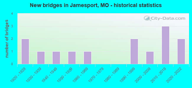
- New bridges - historical statistics
- 21920-1929
- 11930-1939
- 11940-1949
- 11950-1959
- 11960-1969
- 21990-1999
- 12000-2009
- 32010-2019
- 22020-2022


- Bridge Condition - Deck
- 45.5%Excellent
- 9.1%Very good
- 9.1%Good
- 9.1%Satisfactory
- 18.2%Fair
- 9.1%Poor

- Bridge Condition - Superstructure
- 36.4%Excellent
- 18.2%Good
- 18.2%Satisfactory
- 27.3%Fair

- Bridge Condition - Substructure
- 45.5%Excellent
- 9.1%Very good
- 18.2%Satisfactory
- 9.1%Fair
- 18.2%Poor

- Bridge Condition - Channel
- 7.1%Excellent
- 7.1%Good
- 35.7%Satisfactory
- 42.9%Fair
- 7.1%Poor

- Bridge Condition - Culverts
- 33.3%Good
- 66.7%Satisfactory
Find on map >> Show street view
Structure Number: 13322, Location: S 7 T 59 N R 25 W (Lat: 39.938033, Lng: -93.752222), Route carried "on" structure: County highway 35, Year Built: 1993, Status: Open, Structure Length: 1.28m (4.20ft), Average Daily Traffic: 30 (year 2021), Truck Traffic: 10%, Average Future Daily Traffic: 33 (year 2041), Features Intersected: BRANCH OF CLEAR CR, Facility Carried by Structure: COUNTY RD 506
Minimum Vertical Clearance: 30+ m (98+ ft), Kilometerpoint: 8.208, Lanes on structure: 2, Owner: County Highway Agency, Approaching Roadway Width: 7.3m (24.0ft), Material/Design: Concrete, Design/Construction: Culvert, Number Of Spans In Main Unit: 2, Length of Maximum Span: 4.0m (13.1ft)
Condition: Channel: Good, Culverts: Good, Operating Rating: 49.5 metric tons, Method Used To Determine Operating Rating: Load Factor (LF), Inventory Rating: 32.4 metric tons, Method Used To Determine Inventory Rating: Load Factor (LF), Structural Evaluation: Better than present minimum criteria, Waterway Adequacy: Better than present minimum criteria, Approach Roadway Alignment: Equal to present desirable criteria, Designated Inspection Frequency: Every 24 months, Inspection Date: January 2021, Wearing Surface/Protective System: Wearing Surface: Gravel
Find on map >> Show street view
Structure Number: 14836, Location: S 22 T 60 N R 26 W (Lat: 39.991461, Lng: -93.813631), Route carried "on" structure: County highway 77, Year Built: 1957, Status: Posted for load, Structure Length: 1.19m (3.90ft), Average Daily Traffic: 75 (year 2021), Truck Traffic: 10%, Average Future Daily Traffic: 86 (year 2041), Design Load: H 10, Features Intersected: BR E BRUSHY CR, Facility Carried by Structure: 314TH ST
Minimum Vertical Clearance: 30+ m (98+ ft), Kilometerpoint: 0.483, Lanes on structure: 2, Owner: County Highway Agency, Approaching Roadway Width: 6.7m (22.0ft), Material/Design: Steel continuous, Design/Construction: Stringer/Multi-beam, Number Of Spans In Main Unit: 3, Length of Maximum Span: 4.0m (13.1ft), Curb-To-Curb Width: 5.5m (18.0ft), Out-to-Out Width: 5.5m (18.0ft)
Condition: Deck: Satisfactory, Superstructure: Satisfactory, Substructure: Fair, Channel: Fair, Operating Rating: 22.5 metric tons, Method Used To Determine Operating Rating: Allowable Stress (AS), Inventory Rating: 9.9 metric tons, Method Used To Determine Inventory Rating: Allowable Stress (AS), Structural Evaluation: High priority of replacement, Deck Geometry: Meets minimum limits, Waterway Adequacy: Equal to present desirable criteria, Approach Roadway Alignment: Equal to present minimum criteria, Bridge Posting: Required (Relationship of Operating Rating to Maximum Legal Load: 0.1 - 9.9% below), Length Of Structure Improvement: 0.19m (0.62ft), Designated Inspection Frequency: Every 24 months, Inspection Date: January 2022, Bridge Improvement Cost: $138,000, Roadway Improvement Cost: $14,000, Total Project Cost: $206,000 ( Estimate for 2022), Deck Structure Type: Concrete Cast-file-Place, Wearing Surface/Protective System: Wearing Surface: Monolithic Concrete
Find on map >> Show street view
Structure Number: 22645, Location: S 30 T 60 N R 25 W (Lat: 39.983472, Lng: -93.754272), Route carried "on" structure: County highway 366, Year Built: 1995, Status: Open, Structure Length: 1.37m (4.49ft), Average Daily Traffic: 30 (year 2020), Truck Traffic: 25%, Average Future Daily Traffic: 35 (year 2040), Features Intersected: GEES CR, Facility Carried by Structure: SW 82ND AVE
Minimum Vertical Clearance: 30+ m (98+ ft), Kilometerpoint: 3.862, Lanes on structure: 2, Owner: County Highway Agency, Approaching Roadway Width: 4.9m (16.1ft), Material/Design: Steel, Design/Construction: Stringer/Multi-beam, Number Of Spans In Main Unit: 1, Length of Maximum Span: 13.4m (44.0ft), Curb-To-Curb Width: 6.2m (20.3ft), Out-to-Out Width: 6.2m (20.3ft)
Condition: Deck: Very good, Superstructure: Good, Substructure: Satisfactory, Channel: Satisfactory, Operating Rating: 89.1 metric tons, Method Used To Determine Operating Rating: Allowable Stress (AS), Inventory Rating: 55.8 metric tons, Method Used To Determine Inventory Rating: Allowable Stress (AS), Structural Evaluation: Equal to present minimum criteria, Deck Geometry: Somewhat better than minimum adequacy, Waterway Adequacy: Better than present minimum criteria, Approach Roadway Alignment: Equal to present desirable criteria, Designated Inspection Frequency: Every 24 months, Inspection Date: Febuary 2022, Deck Structure Type: Concrete Cast-file-Place, Wearing Surface/Protective System: Wearing Surface: Monolithic Concrete
Find on map >> Show street view
Structure Number: 23803, Location: S 6 T 59 N R 26 W (Lat: 39.961125, Lng: -93.867983), Route carried "on" structure: County highway 434, Year Built: 1920, Status: Posted for load, Structure Length: 0.94m (3.08ft), Average Daily Traffic: 5 (year 2021), Truck Traffic: 10%, Average Future Daily Traffic: 6 (year 2041), Design Load: H 10, Features Intersected: BR OF BRUSHY CR, Facility Carried by Structure: MAJOR AVE
Minimum Vertical Clearance: 30+ m (98+ ft), Kilometerpoint: 0.161, Lanes on structure: 1, Owner: County Highway Agency, Approaching Roadway Width: 5.5m (18.0ft), Material/Design: Steel, Design/Construction: Stringer/Multi-beam, Number Of Spans In Main Unit: 1, Length of Maximum Span: 8.8m (28.9ft), Curb-To-Curb Width: 3.6m (11.8ft), Out-to-Out Width: 3.6m (11.8ft)
Condition: Deck: Fair, Superstructure: Fair, Substructure: Poor, Channel: Fair, Operating Rating: 15.3 metric tons, Method Used To Determine Operating Rating: Allowable Stress (AS), Inventory Rating: 7.2 metric tons, Method Used To Determine Inventory Rating: Allowable Stress (AS), Structural Evaluation: High priority of replacement, Deck Geometry: High priority of corrective action, Waterway Adequacy: Better than present minimum criteria, Approach Roadway Alignment: High priority of corrective action, Bridge Posting: Required (Relationship of Operating Rating to Maximum Legal Load: 30.0 - 39.9% below), Length Of Structure Improvement: 0.16m (0.52ft), Designated Inspection Frequency: Every 24 months, Inspection Date: January 2022, Bridge Improvement Cost: $115,000, Roadway Improvement Cost: $12,000, Total Project Cost: $173,000 ( Estimate for 2022), Deck Structure Type: Concrete Cast-file-Place, Wearing Surface/Protective System: Wearing Surface: Monolithic Concrete
Find on map >> Show street view
Structure Number: 23811, Location: S 5 T 59 N R 26 W (Lat: 39.951817, Lng: -93.855089), Route carried "on" structure: County highway 434, Year Built: 1927, Status: Posted for load, Structure Length: 0.98m (3.22ft), Average Daily Traffic: 35 (year 2021), Truck Traffic: 10%, Average Future Daily Traffic: 40 (year 2041), Design Load: H 10, Features Intersected: THOMPSON CR, Facility Carried by Structure: 290TH ST
Minimum Vertical Clearance: 30+ m (98+ ft), Kilometerpoint: 2.736, Lanes on structure: 1, Owner: County Highway Agency, Approaching Roadway Width: 5.5m (18.0ft), Material/Design: Steel, Design/Construction: Stringer/Multi-beam, Number Of Spans In Main Unit: 1, Length of Maximum Span: 9.1m (29.9ft), Curb-To-Curb Width: 4.3m (14.1ft), Out-to-Out Width: 4.3m (14.1ft)
Condition: Deck: Fair, Superstructure: Fair, Substructure: Poor, Channel: Poor, Operating Rating: 4.5 metric tons, Method Used To Determine Operating Rating: Field evaluation and documented engineering judgment, Inventory Rating: 2.7 metric tons, Method Used To Determine Inventory Rating: Field evaluation and documented engineering judgment, Structural Evaluation: High priority of replacement, Deck Geometry: Equal to present minimum criteria, Waterway Adequacy: Equal to present minimum criteria, Approach Roadway Alignment: Equal to present desirable criteria, Bridge Posting: Required (Relationship of Operating Rating to Maximum Legal Load: > 39.9% below), Length Of Structure Improvement: 0.17m (0.56ft), Designated Inspection Frequency: Every 24 months, Inspection Date: January 2022, Bridge Improvement Cost: $124,000, Roadway Improvement Cost: $12,000, Total Project Cost: $186,000 ( Estimate for 2022), Deck Structure Type: Concrete Cast-file-Place, Wearing Surface/Protective System: Wearing Surface: Monolithic Concrete
Find on map >> Show street view
Structure Number: 30137, Location: S 5 T 59 N R 25 W (Lat: 39.959361, Lng: -93.742553), Route carried "on" structure: State highway U, Year Built: 2004, Status: Open, Structure Length: 14.60m (47.90ft), Average Daily Traffic: 250 (year 2021), Truck Traffic: 11%, Average Future Daily Traffic: 313 (year 2041), Design Load: HS 20, Features Intersected: CLEAR CR, UP RR, TRIB OF
Minimum Vertical Clearance: 7.01m (23.00ft), Kilometerpoint: 1.659, Lanes on structure: 2, Owner: State Highway Agency, Approaching Roadway Width: 7.9m (25.9ft), Material/Design: Prestressed concrete continuous, Design/Construction: Stringer/Multi-beam, Number Of Spans In Main Unit: 6, Length of Maximum Span: 27.1m (88.9ft), Curb-To-Curb Width: 7.9m (25.9ft), Out-to-Out Width: 8.7m (28.5ft)
Condition: Deck: Good, Superstructure: Excellent, Substructure: Very good, Channel: Satisfactory, Operating Rating: 77.4 metric tons, Method Used To Determine Operating Rating: Load Factor (LF), Inventory Rating: 36.9 metric tons, Method Used To Determine Inventory Rating: Load Factor (LF), Structural Evaluation: Equal to present desirable criteria, Deck Geometry: Somewhat better than minimum adequacy, Underclear: Superior to present desirable criteria, Waterway Adequacy: Superior to present desirable criteria, Approach Roadway Alignment: Equal to present desirable criteria, Designated Inspection Frequency: Every 24 months, Inspection Date: October 2020, Deck Structure Type: Concrete Cast-file-Place, Wearing Surface/Protective System: Wearing Surface: Low Slump Concrete, Deck Protection: Epoxy Coated Reinforcing
Find on map >> Show street view
Structure Number: 35389, Location: S 17 T 60 N R 26 W (Lat: 40.008192, Lng: -93.852167), Route carried "on" structure: County highway 431, Year Built: 2017, Status: Open, Structure Length: 2.32m (7.61ft), Average Daily Traffic: 34 (year 2021), Truck Traffic: 10%, Average Future Daily Traffic: 39 (year 2041), Design Load: HS 20, Features Intersected: W. BRUSHY CR, Facility Carried by Structure: CRD 292ND ST
Minimum Vertical Clearance: 30+ m (98+ ft), Kilometerpoint: 1.287, Lanes on structure: 2, Owner: County Highway Agency, Approaching Roadway Width: 7.3m (24.0ft), Skew: 1 degrees, Material/Design: Prestressed concrete, Design/Construction: Stringer/Multi-beam, Number Of Spans In Main Unit: 1, Length of Maximum Span: 22.4m (73.5ft), Curb-To-Curb Width: 7.3m (24.0ft), Out-to-Out Width: 7.3m (24.0ft)
Condition: Deck: Excellent, Superstructure: Excellent, Substructure: Excellent, Channel: Satisfactory, Operating Rating: 57.6 metric tons, Method Used To Determine Operating Rating: Load Factor (LF), Inventory Rating: 34.2 metric tons, Method Used To Determine Inventory Rating: Load Factor (LF), Structural Evaluation: Superior to present desirable criteria, Deck Geometry: Equal to present minimum criteria, Waterway Adequacy: Equal to present desirable criteria, Approach Roadway Alignment: Somewhat better than minimum adequacy, Designated Inspection Frequency: Every 24 months, Inspection Date: January 2022, Deck Structure Type: Concrete Cast-file-Place, Wearing Surface/Protective System: Wearing Surface: Monolithic Concrete
Find on map >> Show street view
Structure Number: 3539, Location: S 29 T 60 N R 26 W (Lat: 39.989444, Lng: -93.851667), Route carried "on" structure: County highway 431, Year Built: 2016, Status: Open, Structure Length: 3.51m (11.52ft), Average Daily Traffic: 35 (year 2021), Truck Traffic: 10%, Average Future Daily Traffic: 40 (year 2041), Design Load: HS 20, Features Intersected: E BUSHY CR, Facility Carried by Structure: CRD 292ND ST
Minimum Vertical Clearance: 30+ m (98+ ft), Kilometerpoint: 3.541, Lanes on structure: 2, Owner: County Highway Agency, Approaching Roadway Width: 7.3m (24.0ft), Skew: 3 degrees, Material/Design: Prestressed concrete, Design/Construction: Tee Beam, Number Of Spans In Main Unit: 1, Length of Maximum Span: 33.8m (110.9ft), Curb-To-Curb Width: 7.3m (24.0ft), Out-to-Out Width: 7.3m (24.0ft)
Condition: Deck: Excellent, Superstructure: Excellent, Substructure: Excellent, Channel: Fair, Operating Rating: 87.3 metric tons, Method Used To Determine Operating Rating: Load Factor (LF), Inventory Rating: 38.7 metric tons, Method Used To Determine Inventory Rating: Load Factor (LF), Structural Evaluation: Superior to present desirable criteria, Deck Geometry: Equal to present minimum criteria, Waterway Adequacy: Equal to present desirable criteria, Approach Roadway Alignment: Somewhat better than minimum adequacy, Designated Inspection Frequency: Every 24 months, Inspection Date: January 2022, Deck Structure Type: Concrete Cast-file-Place, Wearing Surface/Protective System: Wearing Surface: Monolithic Concrete
Find on map >> Show street view
Structure Number: 35828, Location: S 29 T 60 N R 26 W (Lat: 39.986667, Lng: -93.851667), Route carried "on" structure: County highway 431, Year Built: 2016, Status: Open, Structure Length: 1.82m (5.97ft), Average Daily Traffic: 35 (year 2021), Truck Traffic: 10%, Average Future Daily Traffic: 40 (year 2041), Design Load: HS 20, Features Intersected: BR OF BRUSHY CR, Facility Carried by Structure: 292ND ST
Minimum Vertical Clearance: 30+ m (98+ ft), Kilometerpoint: 3.879, Lanes on structure: 2, Owner: County Highway Agency, Approaching Roadway Width: 5.8m (19.0ft), Material/Design: Steel, Number Of Spans In Main Unit: 1, Length of Maximum Span: 13.6m (44.6ft), Curb-To-Curb Width: 6.6m (21.7ft), Out-to-Out Width: 6.8m (22.3ft)
Condition: Deck: Excellent, Superstructure: Satisfactory, Substructure: Excellent, Channel: Fair, Operating Rating: 54.0 metric tons, Method Used To Determine Operating Rating: Load Factor (LF), Inventory Rating: 32.4 metric tons, Method Used To Determine Inventory Rating: Load Factor (LF), Structural Evaluation: Equal to present minimum criteria, Deck Geometry: Somewhat better than minimum adequacy, Waterway Adequacy: Superior to present desirable criteria, Approach Roadway Alignment: Equal to present minimum criteria, Designated Inspection Frequency: Every 24 months, Inspection Date: January 2022, Deck Structure Type: Concrete Cast-file-Place, Wearing Surface/Protective System: Wearing Surface: Monolithic Concrete
Find on map >> Show street view
Structure Number: 3636, Location: S 29 T 60 N R 25 W (Lat: 39.982806, Lng: -93.744836), Route carried "on" structure: County highway 372, Year Built: 2020, Status: Open, Structure Length: 3.26m (10.70ft), Average Daily Traffic: 5 (year 2020), Truck Traffic: 10%, Average Future Daily Traffic: 6 (year 2040), Design Load: HS 20, Features Intersected: GEES CREEK, Facility Carried by Structure: SW 80TH AVE
Minimum Vertical Clearance: 30+ m (98+ ft), Kilometerpoint: 0.644, Lanes on structure: 2, Owner: County Highway Agency, Approaching Roadway Width: 7.3m (24.0ft), Skew: 2 degrees, Material/Design: Prestressed concrete, Design/Construction: Box Beam or Girders - Multiple, Number Of Spans In Main Unit: 1, Length of Maximum Span: 30.3m (99.4ft), Curb-To-Curb Width: 7.3m (24.0ft), Out-to-Out Width: 7.5m (24.6ft)
Condition: Deck: Excellent, Superstructure: Excellent, Substructure: Excellent, Channel: Excellent, Operating Rating: 91.8 metric tons, Method Used To Determine Operating Rating: Load Factor (LF), Inventory Rating: 34.2 metric tons, Method Used To Determine Inventory Rating: Load Factor (LF), Structural Evaluation: Superior to present desirable criteria, Deck Geometry: Equal to present minimum criteria, Waterway Adequacy: Superior to present desirable criteria, Approach Roadway Alignment: Equal to present desirable criteria, Designated Inspection Frequency: Every 24 months, Inspection Date: Febuary 2022, Deck Structure Type: Concrete Precast Panels, Wearing Surface/Protective System: Wearing Surface: Monolithic Concrete, Membrane: Other
Find on map >> Show street view
Structure Number: 36363, Location: S 30 T 60 N R 26 W (Lat: 39.979444, Lng: -93.866111), Route carried "on" structure: County highway 430, Year Built: 2020, Status: Open, Structure Length: 3.17m (10.40ft), Average Daily Traffic: 15 (year 2021), Truck Traffic: 10%, Average Future Daily Traffic: 17 (year 2041), Design Load: HS 20, Features Intersected: BRUSHY CREEK, Facility Carried by Structure: JUMP AVE
Minimum Vertical Clearance: 30+ m (98+ ft), Kilometerpoint: 1.609, Lanes on structure: 2, Owner: County Highway Agency, Approaching Roadway Width: 7.3m (24.0ft), Material/Design: Steel, Design/Construction: Stringer/Multi-beam, Number Of Spans In Main Unit: 2, Length of Maximum Span: 19.5m (64.0ft), Curb-To-Curb Width: 7.3m (24.0ft), Out-to-Out Width: 7.5m (24.6ft)
Condition: Deck: Excellent, Superstructure: Good, Substructure: Excellent, Channel: Satisfactory, Operating Rating: 45.9 metric tons, Method Used To Determine Operating Rating: Load Factor (LF), Inventory Rating: 27.0 metric tons, Method Used To Determine Inventory Rating: Load Factor (LF), Structural Evaluation: Equal to present minimum criteria, Deck Geometry: Equal to present minimum criteria, Waterway Adequacy: Superior to present desirable criteria, Approach Roadway Alignment: Equal to present desirable criteria, Designated Inspection Frequency: Every 24 months, Inspection Date: January 2022
Find on map >> Show street view
Structure Number: 6138, Location: S 23 T 23 N R 12 E (Lat: 36.612872, Lng: -89.728572), Route carried "on" structure: State highway D, Year Built: 1949, Status: Open, Structure Length: 7.53m (24.70ft), Average Daily Traffic: 908 (year 2021), Truck Traffic: 11%, Average Future Daily Traffic: 1,407 (year 2041), Design Load: H 15, Features Intersected: DRAIN DTCH #1
Minimum Vertical Clearance: 30+ m (98+ ft), Kilometerpoint: 21.573, Lanes on structure: 2, Owner: State Highway Agency, Approaching Roadway Width: 6.1m (20.0ft), Material/Design: Steel continuous, Design/Construction: Stringer/Multi-beam, Number Of Spans In Main Unit: 3, Number Of Approach Spans: 2, Length of Maximum Span: 18.3m (60.0ft), Curb-To-Curb Width: 6.7m (22.0ft), Out-to-Out Width: 7.5m (24.6ft)
Condition: Deck: Poor, Superstructure: Fair, Substructure: Satisfactory, Channel: Fair, Operating Rating: 29.7 metric tons, Method Used To Determine Operating Rating: Allowable Stress (AS), Inventory Rating: 18.0 metric tons, Method Used To Determine Inventory Rating: Allowable Stress (AS), Structural Evaluation: Somewhat better than minimum adequacy, Deck Geometry: Meets minimum limits, Waterway Adequacy: Equal to present desirable criteria, Approach Roadway Alignment: Equal to present minimum criteria, Length Of Structure Improvement: 0.85m (2.79ft), Designated Inspection Frequency: Every 24 months, Underwater Inspection Frequency: Every 60 months, Inspection Date: November 2021, Underwater Inspection Date: August 2018, Bridge Improvement Cost: $971,000, Roadway Improvement Cost: $97,000, Total Project Cost: $1,456,000 ( Estimate for 2022), Deck Structure Type: Concrete Cast-file-Place, Wearing Surface/Protective System: Wearing Surface: Bituminous
Find on map >> Show street view
Structure Number: 8308, Location: S 12 T 60 N R 26 W (Lat: 40.017683, Lng: -93.765417), Route carried "on" structure: State highway P, Year Built: 1962, Status: Open, Structure Length: 0.85m (2.79ft), Average Daily Traffic: 168 (year 2021), Truck Traffic: 14%, Average Future Daily Traffic: 218 (year 2041), Design Load: H 15, Features Intersected: HICKORY CR
Minimum Vertical Clearance: 30+ m (98+ ft), Kilometerpoint: 19.311, Lanes on structure: 2, Owner: State Highway Agency, Approaching Roadway Width: 7.3m (24.0ft), Skew: 2 degrees, Material/Design: Concrete continuous, Design/Construction: Culvert, Number Of Spans In Main Unit: 2, Length of Maximum Span: 4.0m (13.1ft), Curb-To-Curb Width: 7.9m (25.9ft), Out-to-Out Width: 8.5m (27.9ft)
Condition: Channel: Satisfactory, Culverts: Satisfactory, Operating Rating: 57.6 metric tons, Method Used To Determine Operating Rating: Load Factor (LF), Inventory Rating: 34.2 metric tons, Method Used To Determine Inventory Rating: Load Factor (LF), Structural Evaluation: Equal to present minimum criteria, Deck Geometry: Somewhat better than minimum adequacy, Waterway Adequacy: Equal to present minimum criteria, Approach Roadway Alignment: Equal to present desirable criteria, Designated Inspection Frequency: Every 24 months, Inspection Date: January 2022
Find on map >> Show street view
Structure Number: 8709, Location: S 23 T 59 N R 26 W (Lat: 39.913781, Lng: -93.789506), Route carried "on" structure: State highway 190, Year Built: 1932, Year Reconstructed: 1972, Status: Open, Structure Length: 0.73m (2.40ft), Average Daily Traffic: 1,022 (year 2021), Truck Traffic: 15%, Average Future Daily Traffic: 1,329 (year 2041), Design Load: H 15, Features Intersected: HURRICANE CR
Minimum Vertical Clearance: 30+ m (98+ ft), Kilometerpoint: 27.377, Lanes on structure: 2, Owner: State Highway Agency, Approaching Roadway Width: 7.3m (24.0ft), Skew: 3 degrees, Material/Design: Concrete continuous, Design/Construction: Culvert, Number Of Spans In Main Unit: 2, Length of Maximum Span: 3.0m (9.8ft), Curb-To-Curb Width: 9.9m (32.5ft), Out-to-Out Width: 10.5m (34.4ft)
Condition: Channel: Fair, Culverts: Satisfactory, Operating Rating: 39.6 metric tons, Method Used To Determine Operating Rating: Load Factor (LF), Inventory Rating: 23.4 metric tons, Method Used To Determine Inventory Rating: Load Factor (LF), Structural Evaluation: Equal to present minimum criteria, Deck Geometry: Somewhat better than minimum adequacy, Waterway Adequacy: Equal to present minimum criteria, Approach Roadway Alignment: Equal to present desirable criteria, Designated Inspection Frequency: Every 24 months, Inspection Date: January 2022