Bridge Statistics for Jarratt, Virginia (VA)
Condition, Traffic, Stress, Structural Evaluation, Project Costs
- National Bridge Inventory (NBI) Statistics
- 21Number of bridges
- 315ft / 96.3mTotal length
- $3,803,000Total costs
- 204,889Total average daily traffic
- 22,331Total average daily truck traffic
- National Bridge Inventory (NBI) Registered Bridges for Jarratt
- No street view available for this location
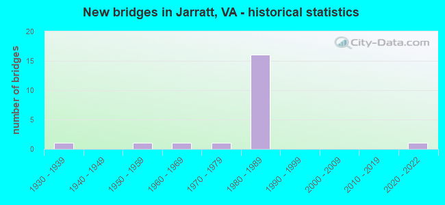
- New bridges - historical statistics
- 11930-1939
- 11950-1959
- 11960-1969
- 11970-1979
- 161980-1989
- 12020-2022


- Bridge Condition - Deck
- 50.0%Good
- 50.0%Satisfactory

- Bridge Condition - Superstructure
- 10.0%Good
- 50.0%Satisfactory
- 40.0%Fair

- Bridge Condition - Substructure
- 10.0%Good
- 60.0%Satisfactory
- 30.0%Fair

- Bridge Condition - Channel
- 11.1%Very good
- 66.7%Good
- 22.2%Satisfactory

- Bridge Condition - Culverts
- 20.0%Very good
- 40.0%Satisfactory
- 40.0%Fair
Find on map >> Show street view
Structure Number: 9052, Location: 2.86 fr 614/0.90 to 301 (Lat: 36.764000, Lng: -77.489144), Route carried "on" structure: Interstate 95, Year Built: 1982, Status: Open, Structure Length: 23.86m (78.28ft), Average Daily Traffic: 16,461 (year 2020), Truck Traffic: 16%, Average Future Daily Traffic: 23,045 (year 2040), Design Load: HS 20+Mod, Features Intersected: Otterdam Swamp
Minimum Vertical Clearance: 30+ m (98+ ft), Kilometerpoint: 26.758, Lanes on structure: 2, Base Highway Network: Yes, Owner: State Highway Agency, Approaching Roadway Width: 12.3m (40.4ft), Material/Design: Steel, Design/Construction: Stringer/Multi-beam, Number Of Spans In Main Unit: 14, Length of Maximum Span: 17.0m (55.8ft), Curb-To-Curb Width: 12.3m (40.4ft), Out-to-Out Width: 13.4m (44.0ft)
Condition: Deck: Good, Superstructure: Fair, Substructure: Fair, Channel: Good, Operating Rating: 76.2 metric tons, Method Used To Determine Operating Rating: Load and Resistance Factor (LRFR), Inventory Rating: 58.1 metric tons, Method Used To Determine Inventory Rating: Load and Resistance Factor (LRFR), Structural Evaluation: Somewhat better than minimum adequacy, Deck Geometry: Better than present minimum criteria, Waterway Adequacy: Equal to present desirable criteria, Approach Roadway Alignment: Equal to present desirable criteria, Length Of Structure Improvement: 23.87m (78.31ft), Designated Inspection Frequency: Every 24 months, Inspection Date: August 2020, Bridge Improvement Cost: $1,353,000, Roadway Improvement Cost: $75,000, Total Project Cost: $1,826,000 ( Estimate for 2015), Deck Structure Type: Concrete Cast-file-Place, Wearing Surface/Protective System: Wearing Surface: Latex Concrete, Deck Protection: Epoxy Coated Reinforcing
Find on map >> Show street view
Structure Number: 9053, Location: 2.86 MI FR INT. RTE. 614 (Lat: 36.763508, Lng: -77.488889), Route carried "on" structure: Interstate 95, Year Built: 1982, Status: Open, Structure Length: 23.87m (78.31ft), Average Daily Traffic: 16,093 (year 2020), Truck Traffic: 16%, Average Future Daily Traffic: 22,530 (year 2040), Design Load: HS 20+Mod, Features Intersected: Otterdam Swamp
Minimum Vertical Clearance: 30+ m (98+ ft), Kilometerpoint: 26.758, Lanes on structure: 2, Base Highway Network: Yes, Owner: State Highway Agency, Approaching Roadway Width: 12.3m (40.4ft), Material/Design: Steel, Design/Construction: Stringer/Multi-beam, Number Of Spans In Main Unit: 14, Length of Maximum Span: 17.1m (56.1ft), Curb-To-Curb Width: 12.3m (40.4ft), Out-to-Out Width: 13.4m (44.0ft)
Condition: Deck: Good, Superstructure: Fair, Substructure: Satisfactory, Channel: Good, Operating Rating: 76.2 metric tons, Method Used To Determine Operating Rating: Load and Resistance Factor (LRFR), Inventory Rating: 59.0 metric tons, Method Used To Determine Inventory Rating: Load and Resistance Factor (LRFR), Structural Evaluation: Somewhat better than minimum adequacy, Deck Geometry: Better than present minimum criteria, Waterway Adequacy: Equal to present desirable criteria, Approach Roadway Alignment: Equal to present desirable criteria, Length Of Structure Improvement: 23.87m (78.31ft), Designated Inspection Frequency: Every 24 months, Inspection Date: August 2020, Bridge Improvement Cost: $1,353,000, Roadway Improvement Cost: $75,000, Total Project Cost: $1,429,000 ( Estimate for 2019), Deck Structure Type: Concrete Cast-file-Place, Wearing Surface/Protective System: Wearing Surface: Latex Concrete, Deck Protection: Epoxy Coated Reinforcing
Find on map >> Show street view
Structure Number: 9054, Location: 3.31 from 614 /0.4 to 301 (Lat: 36.765631, Lng: -77.480714), Route carried "on" structure: Interstate 95, Year Built: 1981, Status: Open, Structure Length: 7.32m (24.02ft), Average Daily Traffic: 16,461 (year 2020), Truck Traffic: 16%, Average Future Daily Traffic: 23,045 (year 2040), Design Load: HS 20+Mod, Features Intersected: CSX Railroad
Minimum Vertical Clearance: 30+ m (98+ ft), Kilometerpoint: 27.530, Lanes on structure: 3, Base Highway Network: Yes, Owner: State Highway Agency, Approaching Roadway Width: 16.0m (52.5ft), Skew: 4 degrees, Material/Design: Steel, Design/Construction: Stringer/Multi-beam, Number Of Spans In Main Unit: 3, Length of Maximum Span: 30.2m (99.1ft), Curb-To-Curb Width: 16.0m (52.5ft), Out-to-Out Width: 17.0m (55.8ft)
Condition: Deck: Good, Superstructure: Satisfactory, Substructure: Satisfactory, Operating Rating: 71.7 metric tons, Method Used To Determine Operating Rating: Load and Resistance Factor (LRFR), Inventory Rating: 55.3 metric tons, Method Used To Determine Inventory Rating: Load and Resistance Factor (LRFR), Structural Evaluation: Equal to present minimum criteria, Deck Geometry: Equal to present minimum criteria, Underclear: Somewhat better than minimum adequacy, Approach Roadway Alignment: Equal to present desirable criteria, Designated Inspection Frequency: Every 24 months, Inspection Date: October 2020, Deck Structure Type: Concrete Cast-file-Place, Wearing Surface/Protective System: Wearing Surface: Latex Concrete, Deck Protection: Epoxy Coated Reinforcing
Find on map >> Show street view
Structure Number: 9055, Location: 3.3 from 615/0.4 to 301 (Lat: 36.765075, Lng: -77.481147), Route carried "on" structure: Interstate 95, Year Built: 1981, Status: Open, Structure Length: 7.32m (24.02ft), Average Daily Traffic: 16,093 (year 2020), Truck Traffic: 16%, Average Future Daily Traffic: 22,530 (year 2040), Design Load: HS 20+Mod, Features Intersected: CSX Railroad
Minimum Vertical Clearance: 30+ m (98+ ft), Kilometerpoint: 27.482, Lanes on structure: 2, Base Highway Network: Yes, Owner: State Highway Agency, Approaching Roadway Width: 12.4m (40.7ft), Skew: 4 degrees, Material/Design: Steel, Design/Construction: Stringer/Multi-beam, Number Of Spans In Main Unit: 3, Length of Maximum Span: 30.2m (99.1ft), Curb-To-Curb Width: 12.4m (40.7ft), Out-to-Out Width: 13.4m (44.0ft)
Condition: Deck: Good, Superstructure: Satisfactory, Substructure: Satisfactory, Operating Rating: 71.7 metric tons, Method Used To Determine Operating Rating: Load and Resistance Factor (LRFR), Inventory Rating: 55.3 metric tons, Method Used To Determine Inventory Rating: Load and Resistance Factor (LRFR), Structural Evaluation: Equal to present minimum criteria, Deck Geometry: Better than present minimum criteria, Underclear: Somewhat better than minimum adequacy, Approach Roadway Alignment: Equal to present desirable criteria, Designated Inspection Frequency: Every 24 months, Inspection Date: October 2020, Deck Structure Type: Concrete Cast-file-Place, Wearing Surface/Protective System: Wearing Surface: Epoxy Overlay, Membrane: Epoxy, Deck Protection: Epoxy Coated Reinforcing
Find on map >> Show street view
Structure Number: 18225, Location: 0.60 Mi Fr Route 646 (Lat: 36.824583, Lng: -77.453197), Route carried "on" structure: ServiceCounty highway F315, Year Built: 1980, Status: Open, Structure Length: 0.70m (2.30ft), Average Daily Traffic: 146 (year 2017), Average Future Daily Traffic: 198 (year 2040), Design Load: HS 20+Mod, Features Intersected: Stream, Facility Carried by Structure: Andrews Road
Minimum Vertical Clearance: 30+ m (98+ ft), Kilometerpoint: 0.869, Lanes on structure: 2, Owner: State Highway Agency, Approaching Roadway Width: 5.8m (19.0ft), Skew: 3 degrees, Material/Design: Steel, Design/Construction: Culvert, Number Of Spans In Main Unit: 3, Length of Maximum Span: 1.8m (5.9ft)
Condition: Channel: Good, Culverts: Satisfactory, Operating Rating: 44.5 metric tons, Method Used To Determine Operating Rating: Load Factor (LF), Inventory Rating: 32.7 metric tons, Method Used To Determine Inventory Rating: Load Factor (LF), Structural Evaluation: Equal to present minimum criteria, Waterway Adequacy: Better than present minimum criteria, Approach Roadway Alignment: Equal to present desirable criteria, Designated Inspection Frequency: Every 24 months, Inspection Date: March 2022
Find on map >> Show street view
Structure Number: 18264, Location: 9.79 Mi Fr Rte 40 (Lat: 36.816361, Lng: -77.456319), Route carried "on" structure: Interstate 95, Year Built: 1982, Status: Open, Structure Length: 3.81m (12.50ft), Average Daily Traffic: 13,925 (year 2020), Truck Traffic: 16%, Average Future Daily Traffic: 19,495 (year 2040), Design Load: HS 20+Mod, Features Intersected: Route 646
Minimum Vertical Clearance: 30+ m (98+ ft), Kilometerpoint: 34.304, Lanes on structure: 2, Lanes under structure: 2, Base Highway Network: Yes, Owner: State Highway Agency, Approaching Roadway Width: 12.8m (42.0ft), Material/Design: Prestressed concrete, Design/Construction: Stringer/Multi-beam, Number Of Spans In Main Unit: 3, Length of Maximum Span: 13.7m (44.9ft), Curb or Sidewalk Widths: Left: 0.2m (0.7ft), Right: 0.2m (0.7ft), Curb-To-Curb Width: 12.3m (40.4ft), Out-to-Out Width: 13.4m (44.0ft)
Condition: Deck: Satisfactory, Superstructure: Satisfactory, Substructure: Fair, Operating Rating: 84.4 metric tons, Method Used To Determine Operating Rating: Load and Resistance Factor (LRFR), Inventory Rating: 58.1 metric tons, Method Used To Determine Inventory Rating: Load and Resistance Factor (LRFR), Structural Evaluation: Somewhat better than minimum adequacy, Deck Geometry: Better than present minimum criteria, Underclear: Meets minimum limits, Approach Roadway Alignment: Equal to present desirable criteria, Designated Inspection Frequency: Every 24 months, Inspection Date: October 2020, Deck Structure Type: Concrete Cast-file-Place, Wearing Surface/Protective System: Wearing Surface: Monolithic Concrete, Deck Protection: Epoxy Coated Reinforcing
Find on map >> Show street view
Structure Number: 18268, Location: 13.50 Mi Fr Rte 40 (Lat: 36.766950, Lng: -77.473706), Route carried "on" structure: Interstate 95, Year Built: 1982, Status: Open, Structure Length: 5.88m (19.29ft), Average Daily Traffic: 16,461 (year 2020), Truck Traffic: 16%, Average Future Daily Traffic: 23,045 (year 2040), Design Load: HS 20+Mod, Features Intersected: Blue Star Highway
Minimum Vertical Clearance: 30+ m (98+ ft), Kilometerpoint: 28.174, Lanes on structure: 2, Lanes under structure: 4, Base Highway Network: Yes, Owner: State Highway Agency, Approaching Roadway Width: 13.1m (43.0ft), Skew: 3 degrees, Material/Design: Steel, Design/Construction: Stringer/Multi-beam, Number Of Spans In Main Unit: 2, Length of Maximum Span: 29.0m (95.1ft), Curb or Sidewalk Widths: Left: 0.2m (0.7ft), Right: 0.2m (0.7ft), Curb-To-Curb Width: 12.9m (42.3ft), Out-to-Out Width: 13.4m (44.0ft)
Condition: Deck: Satisfactory, Superstructure: Satisfactory, Substructure: Satisfactory, Operating Rating: 91.6 metric tons, Method Used To Determine Operating Rating: Load and Resistance Factor (LRFR), Inventory Rating: 69.9 metric tons, Method Used To Determine Inventory Rating: Load and Resistance Factor (LRFR), Structural Evaluation: Equal to present minimum criteria, Deck Geometry: Superior to present desirable criteria, Underclear: Better than present minimum criteria, Approach Roadway Alignment: Equal to present desirable criteria, Designated Inspection Frequency: Every 24 months, Inspection Date: November 2020, Deck Structure Type: Concrete Cast-file-Place, Wearing Surface/Protective System: Wearing Surface: Bituminous, Deck Protection: Epoxy Coated Reinforcing
Find on map >> Show street view
Structure Number: 1827, Location: 13.60 Mi Fr Int Rte 40 (Lat: 36.766511, Lng: -77.473928), Route carried "on" structure: Interstate 95, Year Built: 1982, Status: Open, Structure Length: 5.88m (19.29ft), Average Daily Traffic: 15,988 (year 2020), Truck Traffic: 16%, Average Future Daily Traffic: 22,383 (year 2040), Design Load: HS 20+Mod, Features Intersected: Blue Star Highway
Minimum Vertical Clearance: 30+ m (98+ ft), Kilometerpoint: 28.190, Lanes on structure: 2, Lanes under structure: 4, Base Highway Network: Yes, Owner: State Highway Agency, Approaching Roadway Width: 12.8m (42.0ft), Skew: 3 degrees, Material/Design: Steel, Design/Construction: Stringer/Multi-beam, Number Of Spans In Main Unit: 2, Length of Maximum Span: 29.3m (96.1ft), Curb or Sidewalk Widths: Left: 0.2m (0.7ft), Right: 0.2m (0.7ft), Curb-To-Curb Width: 12.4m (40.7ft), Out-to-Out Width: 13.4m (44.0ft)
Condition: Deck: Satisfactory, Superstructure: Satisfactory, Substructure: Satisfactory, Operating Rating: 91.6 metric tons, Method Used To Determine Operating Rating: Load and Resistance Factor (LRFR), Inventory Rating: 69.9 metric tons, Method Used To Determine Inventory Rating: Load and Resistance Factor (LRFR), Structural Evaluation: Equal to present minimum criteria, Deck Geometry: Better than present minimum criteria, Underclear: Superior to present desirable criteria, Approach Roadway Alignment: Equal to present desirable criteria, Designated Inspection Frequency: Every 24 months, Inspection Date: November 2020, Deck Structure Type: Concrete Cast-file-Place, Wearing Surface/Protective System: Wearing Surface: Monolithic Concrete, Deck Protection: Epoxy Coated Reinforcing
Find on map >> Show street view
Structure Number: 18279, Location: 0.60 Mi To Route 646 (Lat: 36.824472, Lng: -77.454178), Route carried "on" structure: Interstate 95, Year Built: 1980, Status: Open, Structure Length: 0.67m (2.20ft), Average Daily Traffic: 13,925 (year 2020), Truck Traffic: 16%, Average Future Daily Traffic: 19,495 (year 2040), Design Load: HS 20+Mod, Features Intersected: Stream
Minimum Vertical Clearance: 30+ m (98+ ft), Kilometerpoint: 35.205, Lanes on structure: 2, Base Highway Network: Yes, Owner: State Highway Agency, Approaching Roadway Width: 11.0m (36.1ft), Skew: 3 degrees, Material/Design: Steel, Design/Construction: Culvert, Number Of Spans In Main Unit: 3, Length of Maximum Span: 1.8m (5.9ft)
Condition: Channel: Satisfactory, Culverts: Fair, Operating Rating: 54.4 metric tons, Method Used To Determine Operating Rating: Load Factor (LF), Inventory Rating: 32.7 metric tons, Method Used To Determine Inventory Rating: Load Factor (LF), Structural Evaluation: Somewhat better than minimum adequacy, Waterway Adequacy: Better than present minimum criteria, Approach Roadway Alignment: Equal to present desirable criteria, Designated Inspection Frequency: Every 24 months, Inspection Date: March 2022
Find on map >> Show street view
Structure Number: 1828, Location: 0.60 Mi Fr Route 646 (Lat: 36.824492, Lng: -77.453700), Route carried "on" structure: Interstate 95, Year Built: 1980, Status: Open, Structure Length: 0.67m (2.20ft), Average Daily Traffic: 13,044 (year 2020), Truck Traffic: 16%, Average Future Daily Traffic: 18,262 (year 2040), Design Load: HS 20+Mod, Features Intersected: Stream
Minimum Vertical Clearance: 30+ m (98+ ft), Kilometerpoint: 35.221, Lanes on structure: 2, Base Highway Network: Yes, Owner: State Highway Agency, Approaching Roadway Width: 9.1m (29.9ft), Skew: 3 degrees, Material/Design: Steel, Design/Construction: Culvert, Number Of Spans In Main Unit: 3, Length of Maximum Span: 1.8m (5.9ft)
Condition: Channel: Satisfactory, Culverts: Fair, Operating Rating: 54.4 metric tons, Method Used To Determine Operating Rating: Load Factor (LF), Inventory Rating: 32.7 metric tons, Method Used To Determine Inventory Rating: Load Factor (LF), Structural Evaluation: Somewhat better than minimum adequacy, Waterway Adequacy: Better than present minimum criteria, Approach Roadway Alignment: Equal to present desirable criteria, Designated Inspection Frequency: Every 24 months, Inspection Date: March 2020
Find on map >> Show street view
Structure Number: 18315, Location: 1.40 from 631/.10 to 611 (Lat: 36.782142, Lng: -77.420864), Route carried "on" structure: County highway 610, Year Built: 1932, Year Reconstructed: 1993, Status: Posted for load, Structure Length: 0.82m (2.69ft), Average Daily Traffic: 392 (year 2019), Truck Traffic: 3%, Average Future Daily Traffic: 433 (year 2040), Features Intersected: S Fork Poplar Swamp, Facility Carried by Structure: Harrell Road
Minimum Vertical Clearance: 30+ m (98+ ft), Kilometerpoint: 7.763, Lanes on structure: 2, Owner: State Highway Agency, Approaching Roadway Width: 4.9m (16.1ft), Material/Design: Steel, Design/Construction: Stringer/Multi-beam, Number Of Spans In Main Unit: 1, Length of Maximum Span: 8.2m (26.9ft), Curb or Sidewalk Widths: Left: 0.2m (0.7ft), Right: 0.2m (0.7ft), Curb-To-Curb Width: 6.1m (20.0ft), Out-to-Out Width: 6.7m (22.0ft)
Condition: Deck: Good, Superstructure: Fair, Substructure: Good, Channel: Good, Operating Rating: 17.1 metric tons, Method Used To Determine Operating Rating: Load and Resistance Factor (LRFR), Inventory Rating: 13.2 metric tons, Method Used To Determine Inventory Rating: Load and Resistance Factor (LRFR), Structural Evaluation: Meets minimum limits, Deck Geometry: Meets minimum limits, Waterway Adequacy: Equal to present minimum criteria, Approach Roadway Alignment: Equal to present minimum criteria, Bridge Posting: Required (Relationship of Operating Rating to Maximum Legal Load: > 39.9% below), Length Of Structure Improvement: 1.52m (4.99ft), Designated Inspection Frequency: Every 12 months, Inspection Date: March 2022, Bridge Improvement Cost: $136,000, Roadway Improvement Cost: $14,000, Total Project Cost: $151,000 ( Estimate for 2016), Deck Structure Type: Wood or Timber, Wearing Surface/Protective System: Wearing Surface: Gravel
Find on map >> Show street view
Structure Number: 18339, Location: 0.25 fr 656/0.37 to 649 (Lat: 36.868381, Lng: -77.495528), Route carried "on" structure: County highway 630, Year Built: 1964, Status: Open, Structure Length: 0.98m (3.22ft), Average Daily Traffic: 248 (year 2020), Truck Traffic: 2%, Average Future Daily Traffic: 273 (year 2040), Design Load: HS 20, Features Intersected: Harris Swamp, Facility Carried by Structure: Little Mill Road
Minimum Vertical Clearance: 30+ m (98+ ft), Kilometerpoint: 2.320, Lanes on structure: 2, Owner: State Highway Agency, Approaching Roadway Width: 5.5m (18.0ft), Skew: 4 degrees, Material/Design: Concrete, Design/Construction: Culvert, Number Of Spans In Main Unit: 3, Length of Maximum Span: 3.0m (9.8ft)
Condition: Channel: Good, Culverts: Satisfactory, Operating Rating: 89.8 metric tons, Method Used To Determine Operating Rating: Load Factor (LF), Inventory Rating: 62.6 metric tons, Method Used To Determine Inventory Rating: Load Factor (LF), Structural Evaluation: Equal to present minimum criteria, Waterway Adequacy: Equal to present minimum criteria, Approach Roadway Alignment: Equal to present desirable criteria, Designated Inspection Frequency: Every 24 months, Inspection Date: Febuary 2021
Find on map >> Show street view
Structure Number: 1834, Location: 1.23 fr 656/2.12 to 648 (Lat: 36.847619, Lng: -77.492989), Route carried "on" structure: County highway 630, Year Built: 1950, Status: Open, Structure Length: 5.33m (17.49ft), Average Daily Traffic: 367 (year 2020), Truck Traffic: 1%, Average Future Daily Traffic: 404 (year 2040), Design Load: HS 20+Mod, Features Intersected: Nottoway River, Facility Carried by Structure: Little Mill Road
Minimum Vertical Clearance: 30+ m (98+ ft), Kilometerpoint: 4.006, Lanes on structure: 2, Owner: State Highway Agency, Approaching Roadway Width: 5.5m (18.0ft), Skew: 3 degrees, Material/Design: Steel, Design/Construction: Stringer/Multi-beam, Number Of Spans In Main Unit: 3, Length of Maximum Span: 20.6m (67.6ft), Curb or Sidewalk Widths: Left: 0.3m (1.0ft), Right: 0.3m (1.0ft), Curb-To-Curb Width: 6.1m (20.0ft), Out-to-Out Width: 7.3m (24.0ft)
Condition: Deck: Satisfactory, Superstructure: Good, Substructure: Fair, Channel: Good, Operating Rating: 35.7 metric tons, Method Used To Determine Operating Rating: Load and Resistance Factor (LRFR), Inventory Rating: 27.5 metric tons, Method Used To Determine Inventory Rating: Load and Resistance Factor (LRFR), Structural Evaluation: Somewhat better than minimum adequacy, Deck Geometry: Meets minimum limits, Waterway Adequacy: Equal to present minimum criteria, Approach Roadway Alignment: Equal to present desirable criteria, Length Of Structure Improvement: 5.33m (17.49ft), Designated Inspection Frequency: Every 24 months, Underwater Inspection Frequency: Every 60 months, Inspection Date: October 2021, Underwater Inspection Date: April 2020, Bridge Improvement Cost: $210,000, Roadway Improvement Cost: $50,000, Total Project Cost: $261,000 ( Estimate for 2018), Deck Structure Type: Concrete Cast-file-Place, Wearing Surface/Protective System: Wearing Surface: Epoxy Overlay
Find on map >> Show street view
Structure Number: 18346, Location: 0.20 Mi Fr Int Rte 301 (Lat: 36.804964, Lng: -77.459344), Route carried "on" structure: County highway 631, Year Built: 1980, Status: Open, Structure Length: 8.20m (26.90ft), Average Daily Traffic: 709 (year 2020), Truck Traffic: 2%, Average Future Daily Traffic: 780 (year 2040), Design Load: HS 20+Mod, Features Intersected: IS 95, Facility Carried by Structure: Jarratt Ave
Minimum Vertical Clearance: 30+ m (98+ ft), Kilometerpoint: 0.290, Lanes on structure: 4, Lanes under structure: 4, Owner: State Highway Agency, Approaching Roadway Width: 20.7m (67.9ft), Skew: 22 degrees, Material/Design: Steel, Design/Construction: Stringer/Multi-beam, Number Of Spans In Main Unit: 4, Length of Maximum Span: 29.6m (97.1ft), Curb or Sidewalk Widths: Left: 0.2m (0.7ft), Right: 0.2m (0.7ft), Curb-To-Curb Width: 20.7m (67.9ft), Out-to-Out Width: 21.3m (69.9ft)
Condition: Deck: Satisfactory, Superstructure: Fair, Substructure: Satisfactory, Operating Rating: 70.1 metric tons, Method Used To Determine Operating Rating: Load and Resistance Factor (LRFR), Inventory Rating: 54.1 metric tons, Method Used To Determine Inventory Rating: Load and Resistance Factor (LRFR), Structural Evaluation: Somewhat better than minimum adequacy, Deck Geometry: Superior to present desirable criteria, Underclear: Equal to present minimum criteria, Approach Roadway Alignment: Equal to present desirable criteria, Designated Inspection Frequency: Every 24 months, Inspection Date: October 2020, Deck Structure Type: Concrete Cast-file-Place, Wearing Surface/Protective System: Wearing Surface: Monolithic Concrete, Deck Protection: Epoxy Coated Reinforcing
Find on map >> Show street view
Structure Number: 31469, Location: 0.80 Mi.Fr. Int. Rte. 610 (Lat: 36.794986, Lng: -77.507544), Route carried "on" structure: County highway 614, Year Built: 2020, Status: Open, Structure Length: 1.01m (3.31ft), Average Daily Traffic: 137 (year 2014), Average Future Daily Traffic: 180 (year 2035), Design Load: HL 93, Features Intersected: Otterdam Swamp, Facility Carried by Structure: Otterdam Road
Minimum Vertical Clearance: 30+ m (98+ ft), Kilometerpoint: 10.980, Lanes on structure: 2, Owner: State Highway Agency, Approaching Roadway Width: 7.9m (25.9ft), Material/Design: Concrete, Design/Construction: Culvert, Number Of Spans In Main Unit: 3, Length of Maximum Span: 3.0m (9.8ft)
Condition: Channel: Very good, Culverts: Very good, Operating Rating: 89.8 metric tons, Method Used To Determine Operating Rating: Load and Resistance Factor (LRFR), Inventory Rating: 88.3 metric tons, Method Used To Determine Inventory Rating: Load and Resistance Factor (LRFR), Structural Evaluation: Equal to present desirable criteria, Waterway Adequacy: Equal to present desirable criteria, Approach Roadway Alignment: Better than present minimum criteria, Length Of Structure Improvement: 1.37m (4.49ft), Designated Inspection Frequency: Every 24 months, Inspection Date: November 2020, Bridge Improvement Cost: $97,000, Roadway Improvement Cost: $18,000, Total Project Cost: $136,000
Find on map >> Show street view
Structure Number: 18264, Location: 9.79 Mi Fr Rte 40 (Lat: 36.816361, Lng: -77.456319), Route carried "under" structure: County highway 646, Year Built: 1982, Structure Length: 0. m, Average Daily Traffic: 689 (year 2008), Features Intersected: Route 646, Facility Carried by Structure: IS 95 SBL
Minimum Vertical Clearance: 5.21m (17.09ft), Kilometerpoint: 4.087, Lanes on structure: 2, Lanes under structure: 2, Material/Design: Prestressed concrete, Design/Construction: Stringer/Multi-beam, Length of Maximum Span: 13.7m (44.9ft)
Find on map >> Show street view
Structure Number: 18266, Location: 0.83 Mi to Int Rte. 631 (Lat: 36.816278, Lng: -77.455922), Route carried "under" structure: County highway 646, Year Built: 1982, Structure Length: 0. m, Average Daily Traffic: 689 (year 2008), Features Intersected: Route 646, Facility Carried by Structure: IS 95 NBL
Minimum Vertical Clearance: 4.98m (16.34ft), Kilometerpoint: 4.087, Lanes on structure: 2, Lanes under structure: 2, Material/Design: Prestressed concrete, Design/Construction: Stringer/Multi-beam, Length of Maximum Span: 13.7m (44.9ft)
Find on map >> Show street view
Structure Number: 18268, Location: 13.50 Mi Fr Rte 40 (Lat: 36.766950, Lng: -77.473706), Route carried "under" structure: US 301, Year Built: 1982, Structure Length: 0. m, Average Daily Traffic: 1,687 (year 2008), Truck Traffic: 3%, Features Intersected: Blue Star Highway, Facility Carried by Structure: IS 95 SBL
Minimum Vertical Clearance: 5.31m (17.42ft), Kilometerpoint: 27.771, Lanes on structure: 2, Lanes under structure: 4, Material/Design: Steel, Design/Construction: Stringer/Multi-beam, Length of Maximum Span: 29.0m (95.1ft)
Find on map >> Show street view
Structure Number: 1827, Location: 13.60 Mi Fr Int Rte 40 (Lat: 36.766511, Lng: -77.473928), Route carried "under" structure: US 301, Year Built: 1982, Structure Length: 0. m, Average Daily Traffic: 3,374 (year 2008), Truck Traffic: 3%, Features Intersected: Blue Star Highway, Facility Carried by Structure: IS 95 NBL
Minimum Vertical Clearance: 5.26m (17.26ft), Kilometerpoint: 27.723, Lanes on structure: 2, Lanes under structure: 4, Material/Design: Steel, Design/Construction: Stringer/Multi-beam, Length of Maximum Span: 29.3m (96.1ft)
Find on map >> Show street view
Structure Number: 18346, Location: 0.20 Mi Fr Int Rte 301 (Lat: 36.804964, Lng: -77.459344), Route carried "under" structure: Interstate 95, Year Built: 1980, Structure Length: 0. m, Average Daily Traffic: 28,000 (year 1994), Features Intersected: IS 95, Facility Carried by Structure: Jarratt Ave
Minimum Vertical Clearance: 5.19m (17.03ft), Kilometerpoint: 5.406, Lanes on structure: 4, Lanes under structure: 4, Material/Design: Steel, Design/Construction: Stringer/Multi-beam, Length of Maximum Span: 29.6m (97.1ft)
Find on map >> Show street view
Structure Number: 18367, Location: 0.20 Mi Fr Route 301 (Lat: 36.853408, Lng: -77.424011), Route carried "under" structure: Interstate 95, Year Built: 1979, Structure Length: 0. m, Average Daily Traffic: 30,000 (year 1994), Features Intersected: I-95, Facility Carried by Structure: Owens Road
Minimum Vertical Clearance: 5.87m (19.26ft), Kilometerpoint: 11.810, Lanes on structure: 4, Lanes under structure: 4, Material/Design: Steel continuous, Design/Construction: Stringer/Multi-beam, Length of Maximum Span: 33.8m (110.9ft)