Bridge Statistics for Jeanerette, Louisiana (LA)
Condition, Traffic, Stress, Structural Evaluation, Project Costs
- National Bridge Inventory (NBI) Statistics
- 30Number of bridges
- 561ft / 171mTotal length
- $17,815,000Total costs
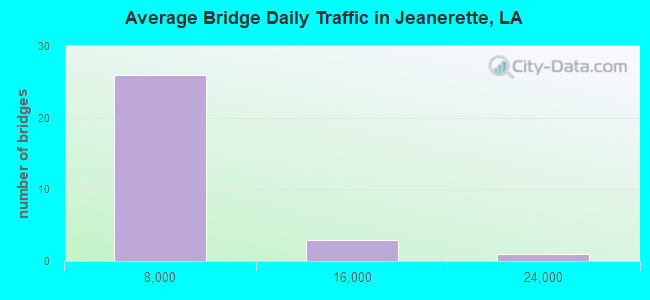
- 82,432Total average daily traffic
- 11,370Total average daily truck traffic
- National Bridge Inventory (NBI) Registered Bridges for Jeanerette
- No street view available for this location
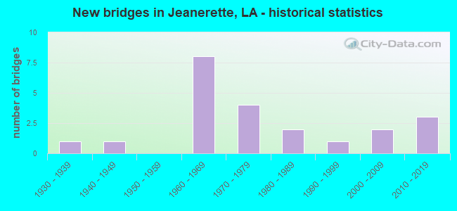
- New bridges - historical statistics
- 11930-1939
- 11940-1949
- 81960-1969
- 41970-1979
- 21980-1989
- 11990-1999
- 22000-2009
- 32010-2019

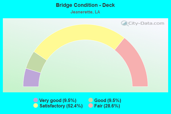
- Bridge Condition - Deck
- 9.5%Very good
- 9.5%Good
- 52.4%Satisfactory
- 28.6%Fair
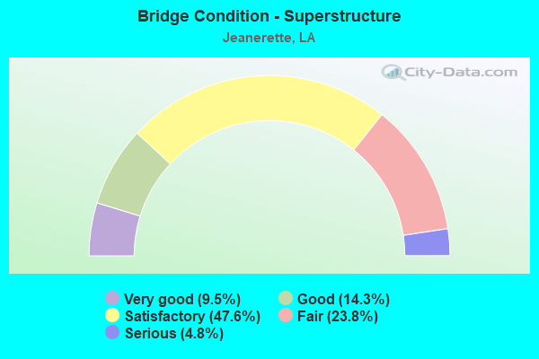
- Bridge Condition - Superstructure
- 9.5%Very good
- 14.3%Good
- 47.6%Satisfactory
- 23.8%Fair
- 4.8%Serious
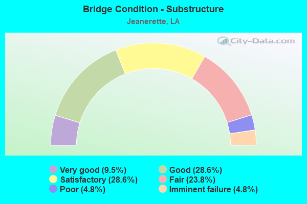
- Bridge Condition - Substructure
- 9.5%Very good
- 28.6%Good
- 28.6%Satisfactory
- 23.8%Fair
- 4.8%Poor
- 4.8%Imminent failure
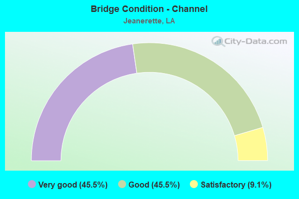
- Bridge Condition - Channel
- 45.5%Very good
- 45.5%Good
- 9.1%Satisfactory
Find on map >> Show street view
Structure Number: 32300000030495, Location: 0.2 MI. S. OF LA 688 (Lat: 29.893369, Lng: -91.682281), Route carried "on" structure: ServiceUS 90, Year Built: 2017, Status: Open, Structure Length: 1.25m (4.10ft), Average Daily Traffic: 2,240 (year 2016), Truck Traffic: 13%, Average Future Daily Traffic: 130 (year 2035), Features Intersected: DRAIN
Minimum Vertical Clearance: 30+ m (98+ ft), Kilometerpoint: 0.296, Lanes on structure: 2, Base Highway Network: Yes (Inventory Route: 424-04-4, Subroute: 20), Owner: State Highway Agency, Approaching Roadway Width: 10.5m (34.4ft), Material/Design: Concrete, Design/Construction: Culvert, Number Of Spans In Main Unit: 3, Length of Maximum Span: 3.7m (12.1ft), Out-to-Out Width: 27.6m (90.6ft)
Condition: Channel: Very good, Culverts: Very good, Operating Rating: 34.3 metric tons, Method Used To Determine Operating Rating: Load and Resistance Factor Rating (LRFR) rating reported by rating factor(RF) method using HL-93 loadings, Inventory Rating: 26.6 metric tons, Method Used To Determine Inventory Rating: Load and Resistance Factor Rating (LRFR) rating reported by rating factor(RF) method using HL-93 loadings, Structural Evaluation: Equal to present minimum criteria, Waterway Adequacy: Better than present minimum criteria, Approach Roadway Alignment: High priority of corrective action, Designated Inspection Frequency: Every 24 months, Inspection Date: May 2021, Wearing Surface/Protective System: Deck Protection: Galvanized Reinforcing
Find on map >> Show street view
Structure Number: 32300000030525, Location: 0.02 Mi W of LA 668 (Lat: 29.883469, Lng: -91.690550), Route carried "on" structure: County highway , Year Built: 2018, Status: Open, Structure Length: 1.83m (6.00ft), Average Daily Traffic: 85 (year 2020), Average Future Daily Traffic: 216 (year 2024), Design Load: Greater than HL93, Features Intersected: Delahossaye Canal, Facility Carried by Structure: Back Rd
Minimum Vertical Clearance: 30+ m (98+ ft), Kilometerpoint: 0.000, Lanes on structure: 2, Owner: County Highway Agency, Approaching Roadway Width: 4.9m (16.1ft), Material/Design: Concrete, Design/Construction: Slab, Number Of Spans In Main Unit: 3, Length of Maximum Span: 6.1m (20.0ft), Curb-To-Curb Width: 6.8m (22.3ft), Out-to-Out Width: 7.9m (25.9ft)
Condition: Deck: Very good, Superstructure: Very good, Substructure: Very good, Channel: Very good, Operating Rating: 57.7 metric tons, Method Used To Determine Operating Rating: Load and Resistance Factor Rating (LRFR) rating reported by rating factor(RF) method using HL-93 loadings, Inventory Rating: 44.4 metric tons, Method Used To Determine Inventory Rating: Load and Resistance Factor Rating (LRFR) rating reported by rating factor(RF) method using HL-93 loadings, Structural Evaluation: Equal to present desirable criteria, Deck Geometry: Somewhat better than minimum adequacy, Waterway Adequacy: Equal to present desirable criteria, Approach Roadway Alignment: Meets minimum limits, Designated Inspection Frequency: Every 24 months, Inspection Date: October 2020, Deck Structure Type: Concrete Precast Panels
Find on map >> Show street view
Structure Number: 32300000030526, Location: 0.1 M NW of LA 668 (Lat: 29.905681, Lng: -91.684111), Route carried "on" structure: County highway , Year Built: 2018, Status: Open, Structure Length: 3.05m (10.01ft), Average Daily Traffic: 1,150 (year 2022), Average Future Daily Traffic: 1,265 (year 2042), Design Load: Greater than HL93, Features Intersected: Delahoussaye Canal, Facility Carried by Structure: Pellerin Rd
Minimum Vertical Clearance: 30+ m (98+ ft), Kilometerpoint: 0.000, Lanes on structure: 2, Owner: County Highway Agency, Approaching Roadway Width: 6.2m (20.3ft), Material/Design: Concrete, Design/Construction: Slab, Number Of Spans In Main Unit: 5, Length of Maximum Span: 6.1m (20.0ft), Curb-To-Curb Width: 8.3m (27.2ft), Out-to-Out Width: 9.3m (30.5ft)
Condition: Deck: Very good, Superstructure: Very good, Substructure: Very good, Channel: Very good, Operating Rating: 59.9 metric tons, Method Used To Determine Operating Rating: Load and Resistance Factor Rating (LRFR) rating reported by rating factor(RF) method using HL-93 loadings, Inventory Rating: 46.3 metric tons, Method Used To Determine Inventory Rating: Load and Resistance Factor Rating (LRFR) rating reported by rating factor(RF) method using HL-93 loadings, Structural Evaluation: Equal to present desirable criteria, Deck Geometry: Meets minimum limits, Waterway Adequacy: Equal to present desirable criteria, Approach Roadway Alignment: Equal to present desirable criteria, Designated Inspection Frequency: Every 24 months, Inspection Date: October 2020, Deck Structure Type: Concrete Cast-file-Place
Find on map >> Show street view
Structure Number: 32300040506771, Location: 2.5 MI SE OF LA 320 (Lat: 29.956431, Lng: -91.720800), Route carried "on" structure: State highway 182, Year Built: 1930, Status: Posted for load, Structure Length: 1.95m (6.40ft), Average Daily Traffic: 10,390 (year 2020), Truck Traffic: 9%, Average Future Daily Traffic: 11,429 (year 2040), Design Load: H 15, Features Intersected: SANDAGER CANAL
Minimum Vertical Clearance: 30+ m (98+ ft), Kilometerpoint: 10.676, Lanes on structure: 2, Owner: State Highway Agency, Approaching Roadway Width: 12.8m (42.0ft), Material/Design: Steel, Design/Construction: Stringer/Multi-beam, Number Of Spans In Main Unit: 3, Length of Maximum Span: 6.4m (21.0ft), Curb-To-Curb Width: 7.4m (24.3ft), Out-to-Out Width: 7.9m (25.9ft)
Condition: Deck: Satisfactory, Superstructure: Satisfactory, Substructure: Fair, Channel: Good, Operating Rating: 15.9 metric tons, Method Used To Determine Operating Rating: Load and Resistance Factor Rating (LRFR) rating reported by rating factor(RF) method using HL-93 loadings, Inventory Rating: 12.3 metric tons, Method Used To Determine Inventory Rating: Load and Resistance Factor Rating (LRFR) rating reported by rating factor(RF) method using HL-93 loadings, Structural Evaluation: High priority of replacement, Deck Geometry: High priority of replacement, Waterway Adequacy: Better than present minimum criteria, Approach Roadway Alignment: Equal to present desirable criteria, Bridge Posting: Required (Relationship of Operating Rating to Maximum Legal Load: 30.0 - 39.9% below), Length Of Structure Improvement: 2.68m (8.79ft), Designated Inspection Frequency: Every 24 months, Other Special Inspection Frequency: Every 12 months, Inspection Date: May 2021, Other Special Inspection Date: May 2020, Bridge Improvement Cost: $228,000, Total Project Cost: $342,000 ( Estimate for 2016), Deck Structure Type: Concrete Cast-file-Place, Wearing Surface/Protective System: Wearing Surface: Bituminous
Find on map >> Show street view
Structure Number: 32302360206641, Location: 1.1 MI WEST OF LA 182 (Lat: 29.914850, Lng: -91.691900), Route carried "on" structure: State highway 85, Year Built: 1969, Status: Open, Structure Length: 1.74m (5.71ft), Average Daily Traffic: 3,152 (year 2019), Truck Traffic: 9%, Average Future Daily Traffic: 3,467 (year 2039), Design Load: HS 20, Features Intersected: DELAHOUSSAYE CANAL
Minimum Vertical Clearance: 30+ m (98+ ft), Kilometerpoint: 10.746, Lanes on structure: 2, Owner: State Highway Agency, Approaching Roadway Width: 7.0m (23.0ft), Material/Design: Concrete, Design/Construction: Slab, Number Of Spans In Main Unit: 3, Length of Maximum Span: 5.8m (19.0ft), Curb-To-Curb Width: 7.3m (24.0ft), Out-to-Out Width: 8.4m (27.6ft)
Condition: Deck: Fair, Superstructure: Fair, Substructure: Fair, Channel: Good, Operating Rating: 41.7 metric tons, Method Used To Determine Operating Rating: Load Factor (LF), Inventory Rating: 24.5 metric tons, Method Used To Determine Inventory Rating: Load Factor (LF), Structural Evaluation: Somewhat better than minimum adequacy, Deck Geometry: High priority of replacement, Waterway Adequacy: Equal to present desirable criteria, Approach Roadway Alignment: Equal to present desirable criteria, Length Of Structure Improvement: 2.50m (8.20ft), Designated Inspection Frequency: Every 24 months, Underwater Inspection Frequency: Every 60 months, Inspection Date: November 2021, Underwater Inspection Date: July 2020, Bridge Improvement Cost: $213,000, Total Project Cost: $319,000 ( Estimate for 2016), Deck Structure Type: Concrete Precast Panels, Wearing Surface/Protective System: Wearing Surface: Bituminous
Find on map >> Show street view
Structure Number: 32302410100161, Location: 0.16 MI EAST OF LA 182 (Lat: 29.913961, Lng: -91.662800), Route carried "on" structure: State highway 671, Year Built: 1944, Status: Posted for load, Structure Length: 8.96m (29.40ft), Average Daily Traffic: 1,160 (year 2020), Truck Traffic: 9%, Average Future Daily Traffic: 1,276 (year 2040), Design Load: H 15, Features Intersected: BAYOU TECHE JEAN.
Minimum Vertical Clearance: 30+ m (98+ ft), Kilometerpoint: 0.262, Lanes on structure: 2, Owner: State Highway Agency, Approaching Roadway Width: 12.2m (40.0ft), Navigation Control: Yes ( Vertical Clearance: 3.4m (11.2ft), Horizontal Clearance: 15.2m (49.9ft)), Material/Design: Steel, Design/Construction: Movable - Swing, Number Of Spans In Main Unit: 1, Number Of Approach Spans: 4, Length of Maximum Span: 62.2m (204.1ft), Curb-To-Curb Width: 7.3m (24.0ft), Out-to-Out Width: 8.6m (28.2ft)
Condition: Deck: Fair, Superstructure: Serious, Substructure: Poor, Channel: Good, Operating Rating: 14.9 metric tons, Method Used To Determine Operating Rating: Load and Resistance Factor Rating (LRFR) rating reported by rating factor(RF) method using HL-93 loadings, Inventory Rating: 11.3 metric tons, Method Used To Determine Inventory Rating: Load and Resistance Factor Rating (LRFR) rating reported by rating factor(RF) method using HL-93 loadings, Structural Evaluation: High priority of replacement, Deck Geometry: Meets minimum limits, Approach Roadway Alignment: Equal to present desirable criteria, Bridge Posting: Required (Relationship of Operating Rating to Maximum Legal Load: 30.0 - 39.9% below), Length Of Structure Improvement: 9.88m (32.41ft), Designated Inspection Frequency: Every 24 months, Critical Feature Inspection Frequency: Every 24 months, Underwater Inspection Frequency: Every 60 months, Other Special Inspection Frequency: Every 12 months, Inspection Date: May 2021, Critical Feature Inspection Date: May 2021, Underwater Inspection Date: June 2018, Other Special Inspection Date: May 2020, Bridge Improvement Cost: $842,000, Total Project Cost: $1,263,000 ( Estimate for 2016), Deck Structure Type: Open Grating, Wearing Surface/Protective System: Wearing Surface: Monolithic Concrete
Find on map >> Show street view
Structure Number: 32304240420271, Location: US 90 OVER LA 668 (Lat: 29.892261, Lng: -91.685700), Route carried "on" structure: US 90, Year Built: 2003, Status: Open, Structure Length: 57.61m (189.01ft), Average Daily Traffic: 11,200 (year 2016), Truck Traffic: 24%, Average Future Daily Traffic: 13,140 (year 2036), Design Load: HS 20, Features Intersected: LA00668
Minimum Vertical Clearance: 30+ m (98+ ft), Kilometerpoint: 32.686, Lanes on structure: 4, Lanes under structure: 4, Base Highway Network: Yes (Inventory Route: 424-04-1, Subroute: 10), Owner: State Highway Agency, Approaching Roadway Width: 11.6m (38.1ft), Skew: 10 degrees, Material/Design: Prestressed concrete, Design/Construction: Stringer/Multi-beam, Number Of Spans In Main Unit: 27, Length of Maximum Span: 21.3m (69.9ft), Curb or Sidewalk Widths: Left: 0.0m, Right: 1.2m (3.9ft), Curb-To-Curb Width: 12.2m (40.0ft), Out-to-Out Width: 13.0m (42.7ft)
Condition: Deck: Satisfactory, Superstructure: Good, Substructure: Good, Channel: Very good, Operating Rating: 82.5 metric tons, Method Used To Determine Operating Rating: Load Factor (LF), Inventory Rating: 47.2 metric tons, Method Used To Determine Inventory Rating: Load Factor (LF), Structural Evaluation: Better than present minimum criteria, Deck Geometry: High priority of replacement, Underclear: Superior to present desirable criteria, Approach Roadway Alignment: Equal to present desirable criteria, Length Of Structure Improvement: 57.61m (189.01ft), Designated Inspection Frequency: Every 24 months, Inspection Date: August 2021, Bridge Improvement Cost: $4,914,000, Total Project Cost: $7,371,000 ( Estimate for 2016), Deck Structure Type: Concrete Cast-file-Place
Find on map >> Show street view
Structure Number: 32304240420272, Location: US 90 OVER LA 668 (Lat: 29.892469, Lng: -91.685550), Route carried "on" structure: US 90, Year Built: 2003, Status: Open, Structure Length: 57.61m (189.01ft), Average Daily Traffic: 11,200 (year 2016), Truck Traffic: 24%, Average Future Daily Traffic: 13,140 (year 2036), Design Load: HS 20, Features Intersected: LA00668
Minimum Vertical Clearance: 30+ m (98+ ft), Kilometerpoint: 0.597, Lanes on structure: 4, Lanes under structure: 4, Base Highway Network: Yes (Inventory Route: 424-04-2, Subroute: 10), Owner: State Highway Agency, Approaching Roadway Width: 11.6m (38.1ft), Skew: 10 degrees, Material/Design: Prestressed concrete, Design/Construction: Stringer/Multi-beam, Number Of Spans In Main Unit: 27, Length of Maximum Span: 21.3m (69.9ft), Curb-To-Curb Width: 12.2m (40.0ft), Out-to-Out Width: 13.0m (42.7ft)
Condition: Deck: Satisfactory, Superstructure: Good, Substructure: Good, Channel: Very good, Operating Rating: 82.5 metric tons, Method Used To Determine Operating Rating: Load Factor (LF), Inventory Rating: 47.2 metric tons, Method Used To Determine Inventory Rating: Load Factor (LF), Structural Evaluation: Better than present minimum criteria, Deck Geometry: High priority of replacement, Underclear: Superior to present desirable criteria, Approach Roadway Alignment: Equal to present desirable criteria, Length Of Structure Improvement: 57.61m (189.01ft), Designated Inspection Frequency: Every 24 months, Inspection Date: August 2021, Bridge Improvement Cost: $4,914,000, Total Project Cost: $7,371,000 ( Estimate for 2016), Deck Structure Type: Concrete Cast-file-Place
Find on map >> Show street view
Structure Number: 32304240420403, Location: 0.05 W of LA668 (Lat: 29.889969, Lng: -91.685100), Route carried "on" structure: ServiceUS 90, Year Built: 1971, Status: Open, Structure Length: 3.05m (10.01ft), Average Daily Traffic: 21,729 (year 2019), Truck Traffic: 13%, Average Future Daily Traffic: 23,902 (year 2039), Design Load: HS 20, Features Intersected: DRAIN
Minimum Vertical Clearance: 30+ m (98+ ft), Kilometerpoint: 6.206, Lanes on structure: 2, Owner: State Highway Agency, Approaching Roadway Width: 7.6m (24.9ft), Material/Design: Concrete, Design/Construction: Slab, Number Of Spans In Main Unit: 5, Length of Maximum Span: 6.1m (20.0ft), Curb-To-Curb Width: 8.0m (26.2ft), Out-to-Out Width: 8.9m (29.2ft)
Condition: Deck: Satisfactory, Superstructure: Satisfactory, Substructure: Satisfactory, Channel: Very good, Operating Rating: 48.1 metric tons, Method Used To Determine Operating Rating: Load Factor (LF), Inventory Rating: 29.0 metric tons, Method Used To Determine Inventory Rating: Load Factor (LF), Structural Evaluation: Equal to present minimum criteria, Deck Geometry: High priority of replacement, Waterway Adequacy: Equal to present desirable criteria, Approach Roadway Alignment: High priority of corrective action, Length Of Structure Improvement: 3.90m (12.80ft), Designated Inspection Frequency: Every 24 months, Inspection Date: November 2021, Bridge Improvement Cost: $332,000, Total Project Cost: $498,000 ( Estimate for 2016), Deck Structure Type: Concrete Cast-file-Place
Find on map >> Show street view
Structure Number: 32304240420406, Location: 0.10 MI W of LA 668 (Lat: 29.891981, Lng: -91.683281), Route carried "on" structure: Ramp US 90, Year Built: 1971, Status: Open, Structure Length: 3.05m (10.01ft), Average Daily Traffic: 2,240 (year 2016), Truck Traffic: 24%, Average Future Daily Traffic: 1,314 (year 2036), Design Load: HS 20, Features Intersected: DELAHOUSSAYE CANAL
Minimum Vertical Clearance: 30+ m (98+ ft), Kilometerpoint: 0.085, Lanes on structure: 3, Owner: State Highway Agency, Approaching Roadway Width: 7.9m (25.9ft), Skew: 10 degrees, Material/Design: Concrete, Design/Construction: Slab, Number Of Spans In Main Unit: 5, Length of Maximum Span: 6.1m (20.0ft), Curb-To-Curb Width: 15.9m (52.2ft), Out-to-Out Width: 16.9m (55.4ft)
Condition: Deck: Satisfactory, Superstructure: Satisfactory, Substructure: Good, Channel: Good, Operating Rating: 71.7 metric tons, Method Used To Determine Operating Rating: Load Factor (LF), Inventory Rating: 43.5 metric tons, Method Used To Determine Inventory Rating: Load Factor (LF), Structural Evaluation: Equal to present minimum criteria, Deck Geometry: Superior to present desirable criteria, Waterway Adequacy: Equal to present desirable criteria, Approach Roadway Alignment: Equal to present desirable criteria, Designated Inspection Frequency: Every 24 months, Inspection Date: November 2021, Deck Structure Type: Concrete Cast-file-Place
Find on map >> Show street view
Structure Number: 32304240420407, Location: 3.33 Mi SE of LA 85 (Lat: 29.890981, Lng: -91.684400), Route carried "on" structure: Ramp US 90, Year Built: 1971, Status: Open, Structure Length: 3.05m (10.01ft), Average Daily Traffic: 2,240 (year 2016), Truck Traffic: 24%, Average Future Daily Traffic: 1,314 (year 2036), Design Load: HS 20, Features Intersected: DRAIN
Minimum Vertical Clearance: 30+ m (98+ ft), Kilometerpoint: 0.476, Lanes on structure: 3, Owner: State Highway Agency, Approaching Roadway Width: 7.8m (25.6ft), Skew: 10 degrees, Material/Design: Concrete, Design/Construction: Slab, Number Of Spans In Main Unit: 5, Length of Maximum Span: 6.1m (20.0ft), Curb-To-Curb Width: 16.0m (52.5ft), Out-to-Out Width: 16.9m (55.4ft)
Condition: Deck: Satisfactory, Superstructure: Satisfactory, Substructure: Satisfactory, Channel: Very good, Operating Rating: 71.7 metric tons, Method Used To Determine Operating Rating: Load Factor (LF), Inventory Rating: 43.5 metric tons, Method Used To Determine Inventory Rating: Load Factor (LF), Structural Evaluation: Equal to present minimum criteria, Deck Geometry: Superior to present desirable criteria, Waterway Adequacy: Equal to present desirable criteria, Approach Roadway Alignment: Equal to present desirable criteria, Designated Inspection Frequency: Every 24 months, Inspection Date: November 2021, Deck Structure Type: Concrete Cast-file-Place
Find on map >> Show street view
Structure Number: 32308232000171, Location: 0.2 MI SOUTH OF LA 85 (Lat: 29.911789, Lng: -91.733800), Route carried "on" structure: State highway 673, Year Built: 1987, Status: Open, Structure Length: 1.16m (3.81ft), Average Daily Traffic: 580 (year 2016), Truck Traffic: 12%, Average Future Daily Traffic: 638 (year 2036), Design Load: HS 20, Features Intersected: DRAINAGE CANAL
Minimum Vertical Clearance: 30+ m (98+ ft), Kilometerpoint: 0.277, Lanes on structure: 2, Owner: State Highway Agency, Approaching Roadway Width: 7.0m (23.0ft), Material/Design: Concrete, Design/Construction: Slab, Number Of Spans In Main Unit: 2, Length of Maximum Span: 5.8m (19.0ft), Curb-To-Curb Width: 9.8m (32.2ft), Out-to-Out Width: 10.7m (35.1ft)
Condition: Deck: Satisfactory, Superstructure: Satisfactory, Substructure: Fair, Channel: Good, Operating Rating: 29.2 metric tons, Method Used To Determine Operating Rating: Load and Resistance Factor Rating (LRFR) rating reported by rating factor(RF) method using HL-93 loadings, Inventory Rating: 22.4 metric tons, Method Used To Determine Inventory Rating: Load and Resistance Factor Rating (LRFR) rating reported by rating factor(RF) method using HL-93 loadings, Structural Evaluation: Somewhat better than minimum adequacy, Deck Geometry: Equal to present minimum criteria, Waterway Adequacy: Equal to present desirable criteria, Approach Roadway Alignment: Equal to present desirable criteria, Designated Inspection Frequency: Every 24 months, Inspection Date: August 2021, Deck Structure Type: Concrete Precast Panels
Find on map >> Show street view
Structure Number: 32308232800551, Location: 0.55 MI NORTH OF LA 671 (Lat: 29.902561, Lng: -91.683900), Route carried "on" structure: State highway 668, Year Built: 1963, Status: Open, Structure Length: 3.66m (12.01ft), Average Daily Traffic: 1,800 (year 2016), Truck Traffic: 13%, Average Future Daily Traffic: 1,092 (year 2036), Design Load: HS 20, Features Intersected: DELAHOUSSAYE CNL
Minimum Vertical Clearance: 30+ m (98+ ft), Kilometerpoint: 0.869, Lanes on structure: 2, Owner: State Highway Agency, Approaching Roadway Width: 14.0m (45.9ft), Skew: 4 degrees, Material/Design: Concrete, Design/Construction: Slab, Number Of Spans In Main Unit: 6, Length of Maximum Span: 6.1m (20.0ft), Curb-To-Curb Width: 8.5m (27.9ft), Out-to-Out Width: 9.9m (32.5ft)
Condition: Deck: Satisfactory, Superstructure: Satisfactory, Substructure: Good, Channel: Satisfactory, Operating Rating: 45.4 metric tons, Method Used To Determine Operating Rating: Load Factor (LF), Inventory Rating: 27.2 metric tons, Method Used To Determine Inventory Rating: Load Factor (LF), Structural Evaluation: Equal to present minimum criteria, Deck Geometry: Somewhat better than minimum adequacy, Waterway Adequacy: Equal to present desirable criteria, Approach Roadway Alignment: Equal to present desirable criteria, Designated Inspection Frequency: Every 24 months, Inspection Date: December 2020, Deck Structure Type: Concrete Cast-file-Place, Wearing Surface/Protective System: Wearing Surface: Bituminous
Find on map >> Show street view
Structure Number: 32308234300081, Location: 0.08 MI EAST OF LA 182 (Lat: 29.929869, Lng: -91.680300), Route carried "on" structure: State highway 3182, Year Built: 1980, Status: Open, Structure Length: 9.21m (30.22ft), Average Daily Traffic: 2,000 (year 2016), Truck Traffic: 9%, Average Future Daily Traffic: 2,200 (year 2036), Design Load: HS 20, Features Intersected: BAYOU TECHE
Minimum Vertical Clearance: 6.02m (19.75ft), Kilometerpoint: 0.127, Lanes on structure: 2, Owner: State Highway Agency, Approaching Roadway Width: 8.8m (28.9ft), Navigation Control: Yes ( Vertical Clearance: 2.1m (6.9ft), Horizontal Clearance: 18.3m (60.0ft)), Material/Design: Steel, Design/Construction: Movable - Swing, Number Of Spans In Main Unit: 1, Number Of Approach Spans: 8, Length of Maximum Span: 43.3m (142.1ft), Curb or Sidewalk Widths: Left: 0.9m (3.0ft), Right: 0.9m (3.0ft), Curb-To-Curb Width: 7.3m (24.0ft), Out-to-Out Width: 10.0m (32.8ft)
Condition: Deck: Satisfactory, Superstructure: Satisfactory, Substructure: Good, Channel: Good, Operating Rating: 37.2 metric tons, Method Used To Determine Operating Rating: Allowable Stress (AS), Inventory Rating: 21.8 metric tons, Method Used To Determine Inventory Rating: Allowable Stress (AS), Structural Evaluation: Somewhat better than minimum adequacy, Deck Geometry: Meets minimum limits, Waterway Adequacy: Equal to present desirable criteria, Approach Roadway Alignment: Equal to present desirable criteria, Designated Inspection Frequency: Every 24 months, Critical Feature Inspection Frequency: Every 24 months, Underwater Inspection Frequency: Every 60 months, Inspection Date: March 2021, Critical Feature Inspection Date: March 2021, Underwater Inspection Date: June 2018, Deck Structure Type: Open Grating
Find on map >> Show street view
Structure Number: 32329521914201, Location: 1.25 Mi SW of La 668 (Lat: 29.869319, Lng: -91.699469), Route carried "on" structure: County highway , Year Built: 1967, Status: Posted for load, Structure Length: 1.74m (5.71ft), Average Daily Traffic: 19 (year 2020), Average Future Daily Traffic: 78 (year 2036), Design Load: HS 20, Features Intersected: Delahoussaye Canal, Facility Carried by Structure: Eighty Arpent Rd
Minimum Vertical Clearance: 30+ m (98+ ft), Kilometerpoint: 0.000, Lanes on structure: 2, Owner: County Highway Agency, Approaching Roadway Width: 6.7m (22.0ft), Material/Design: Concrete, Design/Construction: Slab, Number Of Spans In Main Unit: 3, Length of Maximum Span: 5.8m (19.0ft), Curb-To-Curb Width: 7.3m (24.0ft), Out-to-Out Width: 8.4m (27.6ft)
Condition: Deck: Fair, Superstructure: Fair, Substructure: Fair, Channel: Good, Operating Rating: 20.4 metric tons, Method Used To Determine Operating Rating: Load and Resistance Factor Rating (LRFR) rating reported by rating factor(RF) method using HL-93 loadings, Inventory Rating: 15.6 metric tons, Method Used To Determine Inventory Rating: Load and Resistance Factor Rating (LRFR) rating reported by rating factor(RF) method using HL-93 loadings, Structural Evaluation: Meets minimum limits, Deck Geometry: Equal to present minimum criteria, Waterway Adequacy: Better than present minimum criteria, Approach Roadway Alignment: High priority of corrective action, Bridge Posting: Required (Relationship of Operating Rating to Maximum Legal Load: 20.0 - 29.9% below), Length Of Structure Improvement: 2.44m (8.01ft), Designated Inspection Frequency: Every 24 months, Underwater Inspection Frequency: Every 60 months, Inspection Date: October 2020, Underwater Inspection Date: June 2018, Bridge Improvement Cost: $145,000, Total Project Cost: $217,000 ( Estimate for 2016), Deck Structure Type: Concrete Precast Panels
Find on map >> Show street view
Structure Number: 32329530914321, Location: 2.1 Mi. S. of La 673 (Lat: 29.884450, Lng: -91.720169), Route carried "on" structure: County highway , Year Built: 1976, Status: Posted for load, Structure Length: 1.74m (5.71ft), Average Daily Traffic: 18 (year 2020), Average Future Daily Traffic: 48 (year 2036), Design Load: HS 20, Features Intersected: Patout Canal, Facility Carried by Structure: Back Rd
Minimum Vertical Clearance: 30+ m (98+ ft), Kilometerpoint: 0.000, Lanes on structure: 2, Owner: County Highway Agency, Approaching Roadway Width: 6.4m (21.0ft), Material/Design: Concrete, Design/Construction: Slab, Number Of Spans In Main Unit: 3, Length of Maximum Span: 5.8m (19.0ft), Curb-To-Curb Width: 8.5m (27.9ft), Out-to-Out Width: 9.6m (31.5ft)
Condition: Deck: Satisfactory, Superstructure: Satisfactory, Substructure: Satisfactory, Channel: Satisfactory, Operating Rating: 20.7 metric tons, Method Used To Determine Operating Rating: Load and Resistance Factor Rating (LRFR) rating reported by rating factor(RF) method using HL-93 loadings, Inventory Rating: 16.2 metric tons, Method Used To Determine Inventory Rating: Load and Resistance Factor Rating (LRFR) rating reported by rating factor(RF) method using HL-93 loadings, Structural Evaluation: Somewhat better than minimum adequacy, Deck Geometry: Better than present minimum criteria, Waterway Adequacy: Equal to present desirable criteria, Approach Roadway Alignment: Equal to present desirable criteria, Bridge Posting: Required (Relationship of Operating Rating to Maximum Legal Load: 20.0 - 29.9% below), Designated Inspection Frequency: Every 24 months, Underwater Inspection Frequency: Every 60 months, Inspection Date: October 2020, Underwater Inspection Date: June 2018, Deck Structure Type: Concrete Precast Panels
Find on map >> Show street view
Structure Number: 32329535914291, Location: 1.10 Mi SW of US 90 (Lat: 29.891969, Lng: -91.713981), Route carried "on" structure: County highway , Year Built: 1967, Status: Posted for load, Structure Length: 1.16m (3.81ft), Average Daily Traffic: 64 (year 2020), Average Future Daily Traffic: 138 (year 2036), Design Load: HS 20, Features Intersected: Coulee, Facility Carried by Structure: Eighty Arpent Rd
Minimum Vertical Clearance: 30+ m (98+ ft), Kilometerpoint: 0.000, Lanes on structure: 2, Owner: County Highway Agency, Approaching Roadway Width: 7.3m (24.0ft), Material/Design: Concrete, Design/Construction: Slab, Number Of Spans In Main Unit: 2, Length of Maximum Span: 5.8m (19.0ft), Curb-To-Curb Width: 7.3m (24.0ft), Out-to-Out Width: 8.3m (27.2ft)
Condition: Deck: Fair, Superstructure: Fair, Substructure: Satisfactory, Channel: Good, Operating Rating: 19.8 metric tons, Method Used To Determine Operating Rating: Load and Resistance Factor Rating (LRFR) rating reported by rating factor(RF) method using HL-93 loadings, Inventory Rating: 15.2 metric tons, Method Used To Determine Inventory Rating: Load and Resistance Factor Rating (LRFR) rating reported by rating factor(RF) method using HL-93 loadings, Structural Evaluation: Meets minimum limits, Deck Geometry: Equal to present minimum criteria, Waterway Adequacy: Equal to present desirable criteria, Approach Roadway Alignment: Equal to present desirable criteria, Bridge Posting: Required (Relationship of Operating Rating to Maximum Legal Load: 20.0 - 29.9% below), Length Of Structure Improvement: 1.80m (5.91ft), Designated Inspection Frequency: Every 24 months, Inspection Date: October 2020, Bridge Improvement Cost: $107,000, Total Project Cost: $160,000 ( Estimate for 2016), Deck Structure Type: Concrete Cast-file-Place, Wearing Surface/Protective System: Wearing Surface: Bituminous
Find on map >> Show street view
Structure Number: 32329535914321, Location: 1.56 Mi SW of US 90 (Lat: 29.891900, Lng: -91.721581), Route carried "on" structure: County highway , Year Built: 1967, Status: Posted for load, Structure Length: 1.74m (5.71ft), Average Daily Traffic: 19 (year 2020), Average Future Daily Traffic: 144 (year 2036), Design Load: HS 20, Features Intersected: Patout Canal, Facility Carried by Structure: Eighty Arpent Rd
Minimum Vertical Clearance: 30+ m (98+ ft), Kilometerpoint: 0.000, Lanes on structure: 2, Owner: County Highway Agency, Approaching Roadway Width: 7.0m (23.0ft), Material/Design: Concrete, Design/Construction: Slab, Number Of Spans In Main Unit: 3, Length of Maximum Span: 5.8m (19.0ft), Curb-To-Curb Width: 7.3m (24.0ft), Out-to-Out Width: 8.3m (27.2ft)
Condition: Deck: Fair, Superstructure: Fair, Substructure: Satisfactory, Channel: Very good, Operating Rating: 16.8 metric tons, Method Used To Determine Operating Rating: Load and Resistance Factor Rating (LRFR) rating reported by rating factor(RF) method using HL-93 loadings, Inventory Rating: 13.0 metric tons, Method Used To Determine Inventory Rating: Load and Resistance Factor Rating (LRFR) rating reported by rating factor(RF) method using HL-93 loadings, Structural Evaluation: Meets minimum limits, Deck Geometry: Equal to present minimum criteria, Waterway Adequacy: Equal to present desirable criteria, Approach Roadway Alignment: Equal to present desirable criteria, Bridge Posting: Required (Relationship of Operating Rating to Maximum Legal Load: 30.0 - 39.9% below), Designated Inspection Frequency: Every 24 months, Underwater Inspection Frequency: Every 60 months, Other Special Inspection Frequency: Every 12 months, Inspection Date: October 2020, Underwater Inspection Date: June 2018, Other Special Inspection Date: October 2021, Deck Structure Type: Concrete Precast Panels, Wearing Surface/Protective System: Wearing Surface: Bituminous
Find on map >> Show street view
Structure Number: 32329539914101, Location: 0.10 Mi SW of La 668 (Lat: 29.899031, Lng: -91.682350), Route carried "on" structure: County highway , Year Built: 1966, Status: Closed, Structure Length: 2.32m (7.61ft), Average Daily Traffic: 90 (year 2020), Average Future Daily Traffic: 54 (year 2036), Design Load: H 15, Features Intersected: DELAHOUSSAYE CANAL, Facility Carried by Structure: Monnot Rd
Minimum Vertical Clearance: 30+ m (98+ ft), Kilometerpoint: 0.000, Lanes on structure: 1, Owner: County Highway Agency, Approaching Roadway Width: 6.4m (21.0ft), Skew: 4 degrees, Material/Design: Wood or Timber, Design/Construction: Stringer/Multi-beam, Number Of Spans In Main Unit: 4, Length of Maximum Span: 5.8m (19.0ft), Curb-To-Curb Width: 7.4m (24.3ft), Out-to-Out Width: 7.9m (25.9ft)
Condition: Deck: Good, Superstructure: Satisfactory, Substructure: Imminent failure, Channel: Very good, Operating Rating: 24.5 metric tons, Method Used To Determine Operating Rating: Allowable Stress (AS), Inventory Rating: 18.1 metric tons, Method Used To Determine Inventory Rating: Allowable Stress (AS), Deck Geometry: Equal to present minimum criteria, Waterway Adequacy: Equal to present desirable criteria, Approach Roadway Alignment: Equal to present desirable criteria, Bridge Posting: Required (Relationship of Operating Rating to Maximum Legal Load: > 39.9% below), Length Of Structure Improvement: 3.08m (10.10ft), Designated Inspection Frequency: Every 24 months, Other Special Inspection Frequency: Every 6 months, Inspection Date: October 2020, Other Special Inspection Date: October 2021, Bridge Improvement Cost: $183,000, Total Project Cost: $274,000 ( Estimate for 2016), Deck Structure Type: Wood or Timber
Find on map >> Show street view
Structure Number: 32329556914251, Location: 1.1 Mi S. of La 182 (Lat: 29.927031, Lng: -91.707950), Route carried "on" structure: County highway , Year Built: 1990, Status: Open, Structure Length: 2.32m (7.61ft), Average Daily Traffic: 56 (year 2020), Average Future Daily Traffic: 18 (year 2036), Design Load: HS 20, Features Intersected: Delahoussaye Canal, Facility Carried by Structure: Burliegh Rd
Minimum Vertical Clearance: 30+ m (98+ ft), Kilometerpoint: 0.000, Lanes on structure: 2, Owner: County Highway Agency, Approaching Roadway Width: 11.6m (38.1ft), Material/Design: Concrete, Design/Construction: Slab, Number Of Spans In Main Unit: 4, Length of Maximum Span: 5.8m (19.0ft), Curb-To-Curb Width: 7.3m (24.0ft), Out-to-Out Width: 8.5m (27.9ft)
Condition: Deck: Satisfactory, Superstructure: Satisfactory, Substructure: Fair, Channel: Very good, Operating Rating: 47.6 metric tons, Method Used To Determine Operating Rating: Load and Resistance Factor Rating (LRFR) rating reported by rating factor(RF) method using HL-93 loadings, Inventory Rating: 36.6 metric tons, Method Used To Determine Inventory Rating: Load and Resistance Factor Rating (LRFR) rating reported by rating factor(RF) method using HL-93 loadings, Structural Evaluation: Somewhat better than minimum adequacy, Deck Geometry: Equal to present minimum criteria, Waterway Adequacy: Equal to present desirable criteria, Approach Roadway Alignment: Equal to present desirable criteria, Designated Inspection Frequency: Every 24 months, Inspection Date: October 2020, Deck Structure Type: Concrete Cast-file-Place
Find on map >> Show street view
Structure Number: 35129523914001, Location: 0.8 Mi S of US 90 (Lat: 29.870339, Lng: -91.666011), Route carried "on" structure: County highway , Year Built: 1967, Status: Posted for load, Structure Length: 1.16m (3.81ft), Average Daily Traffic: 330 (year 1971), Average Future Daily Traffic: 561 (year 2035), Design Load: HS 20, Features Intersected: COULEE, Facility Carried by Structure: Pepper Rd
Minimum Vertical Clearance: 30+ m (98+ ft), Kilometerpoint: 0.000, Lanes on structure: 2, Owner: County Highway Agency, Approaching Roadway Width: 7.9m (25.9ft), Material/Design: Concrete, Design/Construction: Slab, Number Of Spans In Main Unit: 2, Length of Maximum Span: 5.8m (19.0ft), Curb-To-Curb Width: 7.3m (24.0ft), Out-to-Out Width: 8.4m (27.6ft)
Condition: Deck: Fair, Superstructure: Fair, Substructure: Good, Channel: Good, Operating Rating: 13.6 metric tons, Method Used To Determine Operating Rating: Load and Resistance Factor Rating (LRFR) rating reported by rating factor(RF) method using HL-93 loadings, Inventory Rating: 10.7 metric tons, Method Used To Determine Inventory Rating: Load and Resistance Factor Rating (LRFR) rating reported by rating factor(RF) method using HL-93 loadings, Structural Evaluation: High priority of corrective action, Deck Geometry: Somewhat better than minimum adequacy, Waterway Adequacy: Better than present minimum criteria, Approach Roadway Alignment: High priority of corrective action, Bridge Posting: Required (Relationship of Operating Rating to Maximum Legal Load: 20.0 - 29.9% below), Designated Inspection Frequency: Every 24 months, Inspection Date: April 2021, Deck Structure Type: Concrete Cast-file-Place
Find on map >> Show street view
Structure Number: 35129527913991, Location: 0.2 Mi S of US 90 (Lat: 29.878489, Lng: -91.665389), Route carried "on" structure: County highway , Year Built: 1967, Status: Posted for load, Structure Length: 1.74m (5.71ft), Average Daily Traffic: 230 (year 1971), Average Future Daily Traffic: 391 (year 2035), Design Load: HS 20, Features Intersected: COULEE, Facility Carried by Structure: Pepper Rd.
Minimum Vertical Clearance: 30+ m (98+ ft), Kilometerpoint: 0.000, Lanes on structure: 2, Owner: County Highway Agency, Approaching Roadway Width: 7.3m (24.0ft), Material/Design: Concrete, Design/Construction: Slab, Number Of Spans In Main Unit: 3, Length of Maximum Span: 5.8m (19.0ft), Curb-To-Curb Width: 7.3m (24.0ft), Out-to-Out Width: 8.3m (27.2ft)
Condition: Deck: Good, Superstructure: Good, Substructure: Satisfactory, Channel: Good, Operating Rating: 24.6 metric tons, Method Used To Determine Operating Rating: Load and Resistance Factor Rating (LRFR) rating reported by rating factor(RF) method using HL-93 loadings, Inventory Rating: 19.1 metric tons, Method Used To Determine Inventory Rating: Load and Resistance Factor Rating (LRFR) rating reported by rating factor(RF) method using HL-93 loadings, Structural Evaluation: Somewhat better than minimum adequacy, Deck Geometry: Somewhat better than minimum adequacy, Waterway Adequacy: Better than present minimum criteria, Approach Roadway Alignment: Equal to present desirable criteria, Bridge Posting: Required (Relationship of Operating Rating to Maximum Legal Load: 10.0 - 19.9% below), Designated Inspection Frequency: Every 24 months, Inspection Date: April 2021, Deck Structure Type: Concrete Cast-file-Place
Find on map >> Show street view
Structure Number: 32300000030397, Location: .97 MI S OF LA 674 (Lat: 29.919850, Lng: -91.728589), Route carried "under" structure: State highway 85, Structure Length: 0. m, Average Daily Traffic: 1,650 (year 2016), Features Intersected: LA 85 SB UNDER US 90 WB
Minimum Vertical Clearance: 5.33m (17.49ft), Kilometerpoint: 6.890, Lanes on structure: 2, Lanes under structure: 1, Length of Maximum Span: 0.0m
Find on map >> Show street view
Structure Number: 32300000030397, Location: .12 MI N OF 90 SER. RD. (Lat: 29.919839, Lng: -91.728550), Route carried "under" structure: State highway 85, Structure Length: 0. m, Average Daily Traffic: 1,650 (year 2016), Features Intersected: LA 85 NB UNDER US 90 WB
Minimum Vertical Clearance: 5.33m (17.49ft), Kilometerpoint: 5.699, Lanes on structure: 2, Lanes under structure: 1, Length of Maximum Span: 0.0m
Find on map >> Show street view
Structure Number: 32300000030398, Location: .98 MI S OF LA 674 (Lat: 29.919619, Lng: -91.728811), Route carried "under" structure: State highway 85, Structure Length: 0. m, Average Daily Traffic: 1,650 (year 2016), Features Intersected: LA 85 SB UNDER US 90 EB
Minimum Vertical Clearance: 5.33m (17.49ft), Kilometerpoint: 6.922, Lanes on structure: 2, Lanes under structure: 1, Length of Maximum Span: 0.0m
Find on map >> Show street view
Structure Number: 32300000030398, Location: .11 MI N OF 90 SER. RD (Lat: 29.919611, Lng: -91.728669), Route carried "under" structure: State highway 85, Structure Length: 0. m, Average Daily Traffic: 1,650 (year 2016), Features Intersected: LA 85 NB UNDER US 90 EB
Minimum Vertical Clearance: 5.33m (17.49ft), Kilometerpoint: 5.679, Lanes on structure: 2, Lanes under structure: 1, Length of Maximum Span: 0.0m
Find on map >> Show street view
Structure Number: 32304240420271, Location: .12 miles N of 90 S. rd. (Lat: 29.890831, Lng: -91.682969), Route carried "under" structure: State highway 668, Structure Length: 0. m, Average Daily Traffic: 960 (year 2016), Features Intersected: LA 668 NB under US 90 EB
Minimum Vertical Clearance: 5.21m (17.09ft), Kilometerpoint: 2.021, Lanes on structure: 2, Lanes under structure: 2, Length of Maximum Span: 0.0m
Find on map >> Show street view
Structure Number: 32304240420271, Location: .5 miles S of LA 671 (Lat: 29.891000, Lng: -91.683031), Route carried "under" structure: State highway 668, Structure Length: 0. m, Average Daily Traffic: 960 (year 2016), Features Intersected: LA 668 SB under US 90 EB
Minimum Vertical Clearance: 5.18m (16.99ft), Kilometerpoint: 2.937, Lanes on structure: 2, Lanes under structure: 2, Length of Maximum Span: 0.0m
Find on map >> Show street view
Structure Number: 32304240420272, Location: .14 miles N of 90 S. Rd. (Lat: 29.891031, Lng: -91.682811), Route carried "under" structure: State highway 668, Structure Length: 0. m, Average Daily Traffic: 960 (year 2016), Features Intersected: LA 668 NB under US 90 WB
Minimum Vertical Clearance: 5.18m (16.99ft), Kilometerpoint: 2.049, Lanes on structure: 2, Lanes under structure: 2, Length of Maximum Span: 0.0m
Find on map >> Show street view
Structure Number: 32304240420272, Location: .5 miles S of LA 671 (Lat: 29.891211, Lng: -91.682869), Route carried "under" structure: State highway 668, Structure Length: 0. m, Average Daily Traffic: 960 (year 2016), Features Intersected: LA 668 SB under US 90 WB
Minimum Vertical Clearance: 5.24m (17.19ft), Kilometerpoint: 2.908, Lanes on structure: 2, Lanes under structure: 2, Length of Maximum Span: 0.0m