Bridge Statistics for Jefferson, Georgia (GA)
Condition, Traffic, Stress, Structural Evaluation, Project Costs
- National Bridge Inventory (NBI) Statistics
- 38Number of bridges
- 538ft / 164mTotal length
- $158,735,000Total costs
- 622,954Total average daily traffic
- 20,280Total average daily truck traffic
- National Bridge Inventory (NBI) Registered Bridges for Jefferson
- No street view available for this location
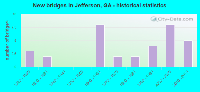
- New bridges - historical statistics
- 31920-1929
- 21930-1939
- 81960-1969
- 21970-1979
- 21980-1989
- 41990-1999
- 82000-2009
- 52010-2019
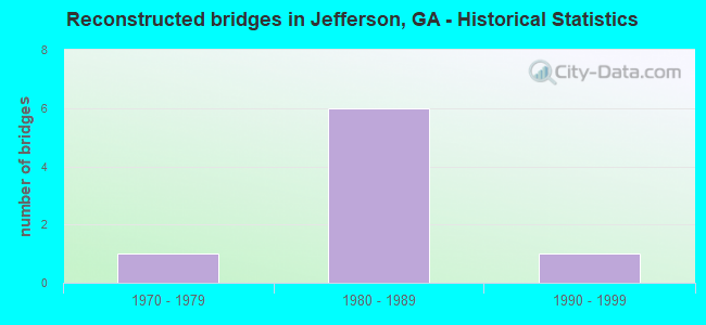
- Reconstructed bridges - Historical Statistics
- 11970-1979
- 61980-1989
- 11990-1999
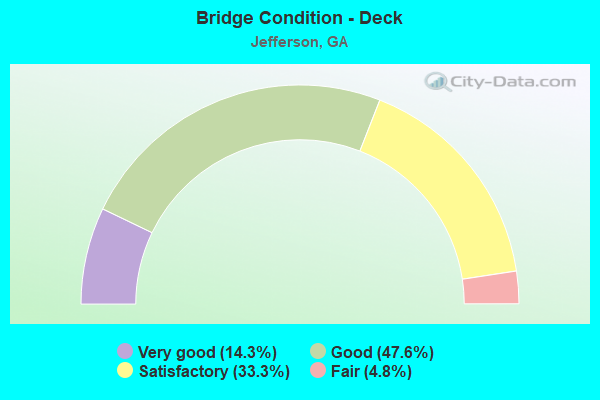
- Bridge Condition - Deck
- 14.3%Very good
- 47.6%Good
- 33.3%Satisfactory
- 4.8%Fair
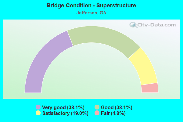
- Bridge Condition - Superstructure
- 38.1%Very good
- 38.1%Good
- 19.0%Satisfactory
- 4.8%Fair
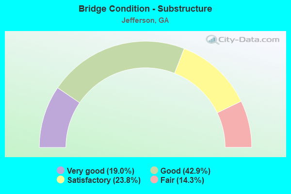
- Bridge Condition - Substructure
- 19.0%Very good
- 42.9%Good
- 23.8%Satisfactory
- 14.3%Fair
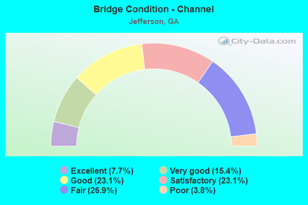
- Bridge Condition - Channel
- 7.7%Excellent
- 15.4%Very good
- 23.1%Good
- 23.1%Satisfactory
- 26.9%Fair
- 3.8%Poor
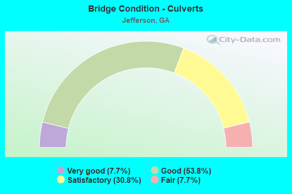
- Bridge Condition - Culverts
- 7.7%Very good
- 53.8%Good
- 30.8%Satisfactory
- 7.7%Fair
Find on map >> Show street view
Structure Number: 135034, Location: 9 MI NE OF WINDER (Lat: 34.045328, Lng: -83.635708), Route carried "on" structure: County highway 237, Year Built: 1980, Status: Posted for load, Structure Length: 3.05m (10.01ft), Average Daily Traffic: 490 (year 2012), Truck Traffic: 1%, Average Future Daily Traffic: 735 (year 2032), Design Load: HS 15, Features Intersected: MULBERRY RIVER OVERFLOW, Facility Carried by Structure: HANCOCK BRIDGE RO
Minimum Vertical Clearance: 30+ m (98+ ft), Kilometerpoint: 3.219, Lanes on structure: 2, Base Highway Network: Yes, Owner: County Highway Agency, Approaching Roadway Width: 6.4m (21.0ft), Material/Design: Concrete, Design/Construction: Tee Beam, Number Of Spans In Main Unit: 3, Length of Maximum Span: 12.2m (40.0ft), Curb-To-Curb Width: 9.3m (30.5ft), Out-to-Out Width: 10.2m (33.5ft)
Condition: Deck: Good, Superstructure: Good, Substructure: Fair, Channel: Very good, Operating Rating: 32.6 metric tons, Method Used To Determine Operating Rating: Load Factor (LF), Inventory Rating: 17.2 metric tons, Method Used To Determine Inventory Rating: Load Factor (LF), Structural Evaluation: Somewhat better than minimum adequacy, Deck Geometry: Equal to present minimum criteria, Waterway Adequacy: Superior to present desirable criteria, Approach Roadway Alignment: Equal to present minimum criteria, Designated Inspection Frequency: Every 24 months, Inspection Date: March 2021, Bridge Improvement Cost: $391,000, Roadway Improvement Cost: $39,000, Total Project Cost: $586,000, Deck Structure Type: Concrete Cast-file-Place
Find on map >> Show street view
Structure Number: 135035, Location: 6.2 MI NE OF WINDER (Lat: 34.046389, Lng: -83.634708), Route carried "on" structure: County highway 237, Year Built: 1980, Status: Open, Structure Length: 8.53m (27.99ft), Average Daily Traffic: 490 (year 2012), Truck Traffic: 1%, Average Future Daily Traffic: 735 (year 2032), Design Load: HS 15, Features Intersected: MULBERRY RIVER, Facility Carried by Structure: HANCOCK ROAD
Minimum Vertical Clearance: 30+ m (98+ ft), Kilometerpoint: 3.219, Lanes on structure: 2, Base Highway Network: Yes, Owner: County Highway Agency, Approaching Roadway Width: 6.4m (21.0ft), Material/Design: Concrete, Design/Construction: Tee Beam, Number Of Spans In Main Unit: 7, Length of Maximum Span: 12.2m (40.0ft), Curb-To-Curb Width: 9.3m (30.5ft), Out-to-Out Width: 10.2m (33.5ft)
Condition: Deck: Good, Superstructure: Very good, Substructure: Fair, Channel: Poor, Operating Rating: 13.6 metric tons, Method Used To Determine Operating Rating: Load Factor (LF), Inventory Rating: 8.1 metric tons, Method Used To Determine Inventory Rating: Load Factor (LF), Structural Evaluation: High priority of corrective action, Deck Geometry: Equal to present minimum criteria, Waterway Adequacy: Somewhat better than minimum adequacy, Approach Roadway Alignment: Equal to present minimum criteria, Designated Inspection Frequency: Every 24 months, Underwater Inspection Frequency: Every 12 months, Inspection Date: March 2021, Underwater Inspection Date: June 2021, Bridge Improvement Cost: $1,094,000, Roadway Improvement Cost: $109,000, Total Project Cost: $1,641,000, Deck Structure Type: Concrete Cast-file-Place
Find on map >> Show street view
Structure Number: 135047, Location: 5 MI N OF STATHAM (Lat: 34.041528, Lng: -83.632228), Route carried "on" structure: County highway 226, Year Built: 1995, Status: Open, Structure Length: 0.70m (2.30ft), Average Daily Traffic: 50 (year 2012), Truck Traffic: 1%, Average Future Daily Traffic: 75 (year 2032), Design Load: H 15, Features Intersected: BARBERS CREEK, Facility Carried by Structure: FINCH DRIVE
Minimum Vertical Clearance: 30+ m (98+ ft), Kilometerpoint: 0.000, Lanes on structure: 2, Base Highway Network: Yes, Owner: County Highway Agency, Approaching Roadway Width: 5.2m (17.1ft), Material/Design: Steel, Design/Construction: Culvert, Number Of Spans In Main Unit: 3, Length of Maximum Span: 2.1m (6.9ft)
Condition: Channel: Satisfactory, Culverts: Good, Operating Rating: 41.7 metric tons, Method Used To Determine Operating Rating: Field evaluation and documented engineering judgment, Inventory Rating: 24.4 metric tons, Method Used To Determine Inventory Rating: Field evaluation and documented engineering judgment, Structural Evaluation: Equal to present minimum criteria, Waterway Adequacy: Better than present minimum criteria, Approach Roadway Alignment: Equal to present minimum criteria, Designated Inspection Frequency: Every 24 months, Underwater Inspection Frequency: Every 60 months, Inspection Date: March 2021, Underwater Inspection Date: June 2021, Bridge Improvement Cost: $90,000, Roadway Improvement Cost: $9,000, Total Project Cost: $135,000
Find on map >> Show street view
Structure Number: 1570002, Location: 5.1 MI SW OF JEFFERSON (Lat: 34.077708, Lng: -83.648469), Route carried "on" structure: State highway 11, Year Built: 1931, Status: Open, Structure Length: 0.64m (2.10ft), Average Daily Traffic: 3,710 (year 2011), Truck Traffic: 11%, Average Future Daily Traffic: 5,565 (year 2031), Design Load: H 15, Features Intersected: MULBERRY RIVER TRIB
Minimum Vertical Clearance: 30+ m (98+ ft), Kilometerpoint: 3.219, Lanes on structure: 2, Base Highway Network: Yes, Owner: State Highway Agency, Approaching Roadway Width: 8.5m (27.9ft), Material/Design: Concrete, Design/Construction: Culvert, Number Of Spans In Main Unit: 2, Length of Maximum Span: 3.0m (9.8ft)
Condition: Channel: Good, Culverts: Good, Operating Rating: 59.8 metric tons, Method Used To Determine Operating Rating: Load Factor (LF), Inventory Rating: 36.2 metric tons, Method Used To Determine Inventory Rating: Load Factor (LF), Structural Evaluation: Better than present minimum criteria, Waterway Adequacy: Superior to present desirable criteria, Approach Roadway Alignment: Equal to present desirable criteria, Designated Inspection Frequency: Every 24 months, Inspection Date: September 2020, Bridge Improvement Cost: $82,000, Roadway Improvement Cost: $8,000, Total Project Cost: $123,000
Find on map >> Show street view
Structure Number: 1570003, Location: 3.5 MI SW OF JEFFERSON (Lat: 34.088808, Lng: -83.623850), Route carried "on" structure: State highway 11, Year Built: 1928, Status: Open, Structure Length: 0.98m (3.22ft), Average Daily Traffic: 3,710 (year 2011), Truck Traffic: 11%, Average Future Daily Traffic: 5,565 (year 2031), Design Load: H 15, Features Intersected: BUFFALO CREEK
Minimum Vertical Clearance: 30+ m (98+ ft), Kilometerpoint: 6.437, Lanes on structure: 2, Base Highway Network: Yes, Owner: State Highway Agency, Approaching Roadway Width: 8.5m (27.9ft), Material/Design: Concrete, Design/Construction: Culvert, Number Of Spans In Main Unit: 3, Length of Maximum Span: 3.0m (9.8ft)
Condition: Channel: Satisfactory, Culverts: Satisfactory, Operating Rating: 59.8 metric tons, Method Used To Determine Operating Rating: Load Factor (LF), Inventory Rating: 36.2 metric tons, Method Used To Determine Inventory Rating: Load Factor (LF), Structural Evaluation: Equal to present minimum criteria, Waterway Adequacy: Superior to present desirable criteria, Approach Roadway Alignment: Equal to present desirable criteria, Designated Inspection Frequency: Every 24 months, Inspection Date: September 2020, Bridge Improvement Cost: $125,000, Roadway Improvement Cost: $13,000, Total Project Cost: $188,000
Find on map >> Show street view
Structure Number: 1570004, Location: 2.5 MI SW OF JEFFERSON (Lat: 34.095597, Lng: -83.606708), Route carried "on" structure: State highway 11, Year Built: 1928, Year Reconstructed: 1981, Status: Open, Structure Length: 14.94m (49.02ft), Average Daily Traffic: 8,520 (year 2012), Truck Traffic: 1%, Average Future Daily Traffic: 12,780 (year 2032), Design Load: H 15, Features Intersected: MIDDLE OCONEE RIVER
Minimum Vertical Clearance: 30+ m (98+ ft), Kilometerpoint: 8.047, Lanes on structure: 2, Base Highway Network: Yes, Owner: State Highway Agency, Approaching Roadway Width: 8.5m (27.9ft), Material/Design: Concrete, Design/Construction: Tee Beam, Number Of Spans In Main Unit: 14, Length of Maximum Span: 14.6m (47.9ft), Curb-To-Curb Width: 14.6m (47.9ft), Out-to-Out Width: 15.6m (51.2ft)
Condition: Deck: Good, Superstructure: Good, Substructure: Good, Channel: Fair, Operating Rating: 85.2 metric tons, Method Used To Determine Operating Rating: Load Factor (LF), Inventory Rating: 50.8 metric tons, Method Used To Determine Inventory Rating: Load Factor (LF), Structural Evaluation: Better than present minimum criteria, Deck Geometry: Superior to present desirable criteria, Waterway Adequacy: Equal to present minimum criteria, Approach Roadway Alignment: Better than present minimum criteria, Designated Inspection Frequency: Every 24 months, Underwater Inspection Frequency: Every 60 months, Inspection Date: September 2020, Underwater Inspection Date: June 2021, Bridge Improvement Cost: $1,915,000, Roadway Improvement Cost: $191,000, Total Project Cost: $2,872,000, Deck Structure Type: Concrete Cast-file-Place
Find on map >> Show street view
Structure Number: 1570005, Location: 4.1 MI NW OF JEFFERSON (Lat: 34.151258, Lng: -83.631889), Route carried "on" structure: US 129, Year Built: 1931, Year Reconstructed: 1986, Status: Open, Structure Length: 0.98m (3.22ft), Average Daily Traffic: 16,560 (year 2011), Truck Traffic: 14%, Average Future Daily Traffic: 24,840 (year 2031), Design Load: H 15, Features Intersected: HOLDERS CREEK
Minimum Vertical Clearance: 30+ m (98+ ft), Kilometerpoint: 19.312, Lanes on structure: 2, Base Highway Network: Yes, Owner: State Highway Agency, Approaching Roadway Width: 8.5m (27.9ft), Material/Design: Concrete, Design/Construction: Culvert, Number Of Spans In Main Unit: 3, Length of Maximum Span: 3.0m (9.8ft)
Condition: Channel: Satisfactory, Culverts: Satisfactory, Operating Rating: 41.7 metric tons, Method Used To Determine Operating Rating: Field evaluation and documented engineering judgment, Inventory Rating: 24.4 metric tons, Method Used To Determine Inventory Rating: Field evaluation and documented engineering judgment, Structural Evaluation: Equal to present minimum criteria, Waterway Adequacy: Superior to present desirable criteria, Approach Roadway Alignment: Equal to present minimum criteria, Designated Inspection Frequency: Every 24 months, Inspection Date: October 2020, Bridge Improvement Cost: $125,000, Roadway Improvement Cost: $13,000, Total Project Cost: $188,000
Find on map >> Show street view
Structure Number: 1570007, Location: 1.5 MI SE OF PENDERGRASS (Lat: 34.152889, Lng: -83.654139), Route carried "on" structure: US 129, Year Built: 1973, Year Reconstructed: 1999, Status: Open, Structure Length: 8.53m (27.99ft), Average Daily Traffic: 11,630 (year 2011), Truck Traffic: 1%, Average Future Daily Traffic: 17,445 (year 2031), Design Load: HS 20+Mod, Features Intersected: MIDDLE OCONEE RIVER
Minimum Vertical Clearance: 30+ m (98+ ft), Kilometerpoint: 20.921, Lanes on structure: 4, Base Highway Network: Yes, Owner: State Highway Agency, Approaching Roadway Width: 16.5m (54.1ft), Skew: 23 degrees, Material/Design: Concrete, Design/Construction: Tee Beam, Number Of Spans In Main Unit: 7, Length of Maximum Span: 12.2m (40.0ft), Curb or Sidewalk Widths: Left: 1.8m (5.9ft), Right: 1.8m (5.9ft), Curb-To-Curb Width: 21.6m (70.9ft), Out-to-Out Width: 26.3m (86.3ft)
Condition: Deck: Satisfactory, Superstructure: Satisfactory, Substructure: Satisfactory, Channel: Fair, Operating Rating: 54.4 metric tons, Method Used To Determine Operating Rating: Load Factor (LF), Inventory Rating: 32.6 metric tons, Method Used To Determine Inventory Rating: Load Factor (LF), Structural Evaluation: Equal to present minimum criteria, Deck Geometry: Superior to present desirable criteria, Waterway Adequacy: Equal to present desirable criteria, Approach Roadway Alignment: Equal to present desirable criteria, Designated Inspection Frequency: Every 24 months, Inspection Date: December 2020, Bridge Improvement Cost: $1,691,000, Roadway Improvement Cost: $169,000, Total Project Cost: $2,536,000, Deck Structure Type: Concrete Cast-file-Place
Find on map >> Show street view
Structure Number: 1570009, Location: IN JEFFERSON (Lat: 34.119358, Lng: -83.569508), Route carried "on" structure: Alternate State highway 15, Year Built: 1929, Status: Open, Structure Length: 4.11m (13.48ft), Average Daily Traffic: 14,020 (year 2011), Truck Traffic: 1%, Average Future Daily Traffic: 21,030 (year 2031), Design Load: H 15, Features Intersected: CURRY CREEK
Minimum Vertical Clearance: 30+ m (98+ ft), Kilometerpoint: 20.921, Lanes on structure: 2, Base Highway Network: Yes, Owner: State Highway Agency, Approaching Roadway Width: 7.6m (24.9ft), Material/Design: Concrete, Design/Construction: Arch - Deck, Number Of Spans In Main Unit: 3, Length of Maximum Span: 13.7m (44.9ft), Curb or Sidewalk Widths: Left: 1.6m (5.2ft), Right: 1.6m (5.2ft), Curb-To-Curb Width: 6.0m (19.7ft), Out-to-Out Width: 10.2m (33.5ft)
Condition: Deck: Good, Superstructure: Good, Substructure: Good, Channel: Good, Operating Rating: 39.9 metric tons, Method Used To Determine Operating Rating: Allowable Stress (AS), Inventory Rating: 17.2 metric tons, Method Used To Determine Inventory Rating: Allowable Stress (AS), Structural Evaluation: Meets minimum limits, Deck Geometry: High priority of replacement, Waterway Adequacy: Superior to present desirable criteria, Approach Roadway Alignment: Somewhat better than minimum adequacy, Length Of Structure Improvement: 44.90m (147.31ft), Designated Inspection Frequency: Every 24 months, Inspection Date: October 2020, Bridge Improvement Cost: $527,000, Roadway Improvement Cost: $53,000, Total Project Cost: $791,000, Deck Structure Type: Concrete Cast-file-Place, Wearing Surface/Protective System: Wearing Surface: Bituminous
Find on map >> Show street view
Structure Number: 1570021, Location: 4.5 MI NW OF JEFFERSON (Lat: 34.160789, Lng: -83.633447), Route carried "on" structure: County highway 229, Year Built: 1964, Status: Posted for load, Structure Length: 8.32m (27.30ft), Average Daily Traffic: 600 (year 2011), Truck Traffic: 1%, Average Future Daily Traffic: 900 (year 2031), Design Load: H 15, Features Intersected: I-85 (SR 403), Facility Carried by Structure: VALENTINE INDUSTRI
Minimum Vertical Clearance: 30+ m (98+ ft), Kilometerpoint: 3.219, Lanes on structure: 2, Lanes under structure: 4, Base Highway Network: Yes, Owner: State Highway Agency, Approaching Roadway Width: 6.7m (22.0ft), Skew: 2 degrees, Material/Design: Steel continuous, Design/Construction: Stringer/Multi-beam, Number Of Spans In Main Unit: 4, Length of Maximum Span: 22.3m (73.2ft), Curb or Sidewalk Widths: Left: 0.5m (1.6ft), Right: 0.5m (1.6ft), Curb-To-Curb Width: 7.3m (24.0ft), Out-to-Out Width: 9.1m (29.9ft)
Condition: Deck: Good, Superstructure: Good, Substructure: Good, Operating Rating: 27.2 metric tons, Method Used To Determine Operating Rating: Load Factor (LF), Inventory Rating: 16.3 metric tons, Method Used To Determine Inventory Rating: Load Factor (LF), Structural Evaluation: Meets minimum limits, Deck Geometry: Meets minimum limits, Underclear: Meets minimum limits, Approach Roadway Alignment: Equal to present minimum criteria, Bridge Posting: Required (Relationship of Operating Rating to Maximum Legal Load: 0.1 - 9.9% below), Designated Inspection Frequency: Every 24 months, Inspection Date: November 2020, Bridge Improvement Cost: $1,067,000, Roadway Improvement Cost: $107,000, Total Project Cost: $1,600,000, Deck Structure Type: Concrete Cast-file-Place
Find on map >> Show street view
Structure Number: 1570039, Location: 1.7 MI SE OF PENDERGRASS (Lat: 34.142303, Lng: -83.661561), Route carried "on" structure: Interstate 85, Year Built: 1964, Year Reconstructed: 1985, Status: Open, Structure Length: 7.32m (24.02ft), Average Daily Traffic: 51,200 (year 2011), Truck Traffic: 1%, Average Future Daily Traffic: 76,800 (year 2031), Design Load: HS 20+Mod, Features Intersected: WALNUT CREEK
Minimum Vertical Clearance: 30+ m (98+ ft), Kilometerpoint: 217.262, Lanes on structure: 2, Base Highway Network: Yes, Owner: State Highway Agency, Approaching Roadway Width: 11.6m (38.1ft), Skew: 12 degrees, Material/Design: Concrete, Design/Construction: Tee Beam, Number Of Spans In Main Unit: 6, Length of Maximum Span: 12.2m (40.0ft), Curb-To-Curb Width: 12.6m (41.3ft), Out-to-Out Width: 13.6m (44.6ft)
Condition: Deck: Satisfactory, Superstructure: Fair, Substructure: Satisfactory, Channel: Fair, Operating Rating: 42.6 metric tons, Method Used To Determine Operating Rating: Load Factor (LF), Inventory Rating: 25.4 metric tons, Method Used To Determine Inventory Rating: Load Factor (LF), Structural Evaluation: Somewhat better than minimum adequacy, Deck Geometry: Better than present minimum criteria, Waterway Adequacy: Superior to present desirable criteria, Approach Roadway Alignment: Equal to present desirable criteria, Designated Inspection Frequency: Every 24 months, Inspection Date: October 2020, Bridge Improvement Cost: $938,000, Roadway Improvement Cost: $94,000, Total Project Cost: $1,407,000, Deck Structure Type: Concrete Cast-file-Place
Find on map >> Show street view
Structure Number: 1570041, Location: 1.8 MI SE OF PENDERGRASS (Lat: 34.146589, Lng: -83.654058), Route carried "on" structure: Interstate 85, Year Built: 1964, Year Reconstructed: 1985, Status: Open, Structure Length: 4.11m (13.48ft), Average Daily Traffic: 51,200 (year 2011), Truck Traffic: 1%, Average Future Daily Traffic: 76,800 (year 2031), Design Load: HS 20+Mod, Features Intersected: CSX RAILROAD
Minimum Vertical Clearance: 30+ m (98+ ft), Kilometerpoint: 218.871, Lanes on structure: 2, Base Highway Network: Yes, Owner: State Highway Agency, Approaching Roadway Width: 11.6m (38.1ft), Skew: 10 degrees, Material/Design: Steel, Design/Construction: Stringer/Multi-beam, Number Of Spans In Main Unit: 3, Length of Maximum Span: 13.7m (44.9ft), Curb-To-Curb Width: 12.7m (41.7ft), Out-to-Out Width: 13.6m (44.6ft)
Condition: Deck: Satisfactory, Superstructure: Good, Substructure: Good, Operating Rating: 31.7 metric tons, Method Used To Determine Operating Rating: Load Factor (LF), Inventory Rating: 19.0 metric tons, Method Used To Determine Inventory Rating: Load Factor (LF), Structural Evaluation: Meets minimum limits, Deck Geometry: Better than present minimum criteria, Underclear: Meets minimum limits, Approach Roadway Alignment: Equal to present desirable criteria, Designated Inspection Frequency: Every 24 months, Inspection Date: November 2020, Bridge Improvement Cost: $527,000, Roadway Improvement Cost: $53,000, Total Project Cost: $791,000, Deck Structure Type: Concrete Cast-file-Place
Find on map >> Show street view
Structure Number: 1570042, Location: 1.8 MI SE OF PENDERGRASS (Lat: 34.146819, Lng: -83.654222), Route carried "on" structure: Interstate 85, Year Built: 1964, Year Reconstructed: 1985, Status: Open, Structure Length: 4.11m (13.48ft), Average Daily Traffic: 51,200 (year 2011), Truck Traffic: 1%, Average Future Daily Traffic: 76,800 (year 2031), Design Load: HS 20+Mod, Features Intersected: CSX RAILROAD
Minimum Vertical Clearance: 30+ m (98+ ft), Kilometerpoint: 218.871, Lanes on structure: 2, Base Highway Network: Yes, Owner: State Highway Agency, Approaching Roadway Width: 11.6m (38.1ft), Skew: 10 degrees, Material/Design: Steel, Design/Construction: Stringer/Multi-beam, Number Of Spans In Main Unit: 3, Length of Maximum Span: 13.7m (44.9ft), Curb-To-Curb Width: 12.7m (41.7ft), Out-to-Out Width: 13.6m (44.6ft)
Condition: Deck: Fair, Superstructure: Good, Substructure: Good, Operating Rating: 31.7 metric tons, Method Used To Determine Operating Rating: Load Factor (LF), Inventory Rating: 19.0 metric tons, Method Used To Determine Inventory Rating: Load Factor (LF), Structural Evaluation: Meets minimum limits, Deck Geometry: Better than present minimum criteria, Underclear: Meets minimum limits, Approach Roadway Alignment: Equal to present desirable criteria, Designated Inspection Frequency: Every 24 months, Other Special Inspection Frequency: Every 24 months, Inspection Date: November 2020, Other Special Inspection Date: September 2021, Bridge Improvement Cost: $527,000, Roadway Improvement Cost: $53,000, Total Project Cost: $791,000, Deck Structure Type: Concrete Cast-file-Place
Find on map >> Show street view
Structure Number: 1570043, Location: 1.9 MI SE OF PENDERGRASS (Lat: 34.148289, Lng: -83.651119), Route carried "on" structure: Interstate 85, Year Built: 1964, Year Reconstructed: 1985, Status: Open, Structure Length: 9.14m (29.99ft), Average Daily Traffic: 51,200 (year 2011), Truck Traffic: 1%, Average Future Daily Traffic: 76,800 (year 2031), Design Load: HS 20+Mod, Features Intersected: MIDDLE OCONEE RIVER
Minimum Vertical Clearance: 30+ m (98+ ft), Kilometerpoint: 218.871, Lanes on structure: 2, Base Highway Network: Yes, Owner: State Highway Agency, Approaching Roadway Width: 11.6m (38.1ft), Skew: 10 degrees, Material/Design: Steel, Design/Construction: Stringer/Multi-beam, Number Of Spans In Main Unit: 1, Number Of Approach Spans: 6, Length of Maximum Span: 18.3m (60.0ft), Curb-To-Curb Width: 12.7m (41.7ft), Out-to-Out Width: 13.8m (45.3ft)
Condition: Deck: Satisfactory, Superstructure: Satisfactory, Substructure: Satisfactory, Channel: Satisfactory, Operating Rating: 49.8 metric tons, Method Used To Determine Operating Rating: Load Factor (LF), Inventory Rating: 29.9 metric tons, Method Used To Determine Inventory Rating: Load Factor (LF), Structural Evaluation: Equal to present minimum criteria, Deck Geometry: Better than present minimum criteria, Waterway Adequacy: Superior to present desirable criteria, Approach Roadway Alignment: Equal to present desirable criteria, Designated Inspection Frequency: Every 24 months, Inspection Date: October 2020, Bridge Improvement Cost: $1,172,000, Roadway Improvement Cost: $117,000, Total Project Cost: $1,758,000, Deck Structure Type: Concrete Cast-file-Place
Find on map >> Show street view
Structure Number: 1570044, Location: 1.9 MI SE OF PENDERGRASS (Lat: 34.148519, Lng: -83.651300), Route carried "on" structure: Interstate 85, Year Built: 1964, Year Reconstructed: 1985, Status: Open, Structure Length: 9.14m (29.99ft), Average Daily Traffic: 51,200 (year 2011), Truck Traffic: 1%, Average Future Daily Traffic: 76,800 (year 2031), Design Load: HS 20+Mod, Features Intersected: MIDDLE OCONEE RIVER
Minimum Vertical Clearance: 30+ m (98+ ft), Kilometerpoint: 218.871, Lanes on structure: 2, Base Highway Network: Yes, Owner: State Highway Agency, Approaching Roadway Width: 11.6m (38.1ft), Skew: 10 degrees, Material/Design: Steel, Design/Construction: Stringer/Multi-beam, Number Of Spans In Main Unit: 1, Number Of Approach Spans: 6, Length of Maximum Span: 18.3m (60.0ft), Curb-To-Curb Width: 15.8m (51.8ft), Out-to-Out Width: 16.7m (54.8ft)
Condition: Deck: Satisfactory, Superstructure: Satisfactory, Substructure: Satisfactory, Channel: Fair, Operating Rating: 35.3 metric tons, Method Used To Determine Operating Rating: Load Factor (LF), Inventory Rating: 20.8 metric tons, Method Used To Determine Inventory Rating: Load Factor (LF), Structural Evaluation: Somewhat better than minimum adequacy, Deck Geometry: Superior to present desirable criteria, Waterway Adequacy: Superior to present desirable criteria, Approach Roadway Alignment: Equal to present desirable criteria, Designated Inspection Frequency: Every 24 months, Inspection Date: October 2020, Bridge Improvement Cost: $1,172,000, Roadway Improvement Cost: $117,000, Total Project Cost: $1,758,000, Deck Structure Type: Concrete Cast-file-Place
Find on map >> Show street view
Structure Number: 1570052, Location: 1.6 MI NE OF PENDERGRASS (Lat: 34.180678, Lng: -83.661019), Route carried "on" structure: County highway 2233, Year Built: 1963, Status: Posted for load, Structure Length: 4.39m (14.40ft), Average Daily Traffic: 1,940 (year 2011), Truck Traffic: 1%, Average Future Daily Traffic: 2,910 (year 2031), Design Load: H 15, Features Intersected: POND FORK CREEK, Facility Carried by Structure: WAYNE POULTRY ROAD
Minimum Vertical Clearance: 30+ m (98+ ft), Kilometerpoint: 3.219, Lanes on structure: 2, Base Highway Network: Yes, Owner: County Highway Agency, Approaching Roadway Width: 6.4m (21.0ft), Material/Design: Concrete, Design/Construction: Tee Beam, Number Of Spans In Main Unit: 4, Length of Maximum Span: 11.0m (36.1ft), Curb or Sidewalk Widths: Left: 0.6m (2.0ft), Right: 0.6m (2.0ft), Curb-To-Curb Width: 7.3m (24.0ft), Out-to-Out Width: 9.1m (29.9ft)
Condition: Deck: Satisfactory, Superstructure: Satisfactory, Substructure: Satisfactory, Channel: Good, Operating Rating: 30.8 metric tons, Method Used To Determine Operating Rating: Load Factor (LF), Inventory Rating: 18.1 metric tons, Method Used To Determine Inventory Rating: Load Factor (LF), Structural Evaluation: Somewhat better than minimum adequacy, Deck Geometry: Meets minimum limits, Waterway Adequacy: Superior to present desirable criteria, Approach Roadway Alignment: Equal to present desirable criteria, Bridge Posting: Required (Relationship of Operating Rating to Maximum Legal Load: 0.1 - 9.9% below), Length Of Structure Improvement: 10.82m (35.50ft), Designated Inspection Frequency: Every 24 months, Inspection Date: December 2020, Bridge Improvement Cost: $563,000, Roadway Improvement Cost: $56,000, Total Project Cost: $844,000, Deck Structure Type: Concrete Cast-file-Place
Find on map >> Show street view
Structure Number: 1575026, Location: 6 MI SW OF JEFFERSON (Lat: 34.058319, Lng: -83.649247), Route carried "on" structure: County highway 156, Year Built: 1994, Status: Open, Structure Length: 0.98m (3.22ft), Average Daily Traffic: 104 (year 2011), Truck Traffic: 1%, Average Future Daily Traffic: 156 (year 2031), Design Load: H 15, Features Intersected: MULBERRY RIVER TRIB., Facility Carried by Structure: OLD WINDER-JEFF RD
Minimum Vertical Clearance: 30+ m (98+ ft), Kilometerpoint: 1.609, Lanes on structure: 2, Base Highway Network: Yes, Owner: County Highway Agency, Approaching Roadway Width: 4.3m (14.1ft), Material/Design: Steel, Design/Construction: Culvert, Number Of Spans In Main Unit: 4, Length of Maximum Span: 1.8m (5.9ft)
Condition: Channel: Fair, Culverts: Satisfactory, Operating Rating: 41.7 metric tons, Method Used To Determine Operating Rating: Field evaluation and documented engineering judgment, Inventory Rating: 24.4 metric tons, Method Used To Determine Inventory Rating: Field evaluation and documented engineering judgment, Structural Evaluation: Equal to present minimum criteria, Waterway Adequacy: Meets minimum limits, Approach Roadway Alignment: Better than present minimum criteria, Designated Inspection Frequency: Every 24 months, Inspection Date: September 2020, Bridge Improvement Cost: $125,000, Roadway Improvement Cost: $13,000, Total Project Cost: $188,000
Find on map >> Show street view
Structure Number: 1575037, Location: 3.2 MI SE OF PENDERGRASS (Lat: 34.129697, Lng: -83.639839), Route carried "on" structure: County highway 217, Year Built: 1960, Status: Posted for load, Structure Length: 7.32m (24.02ft), Average Daily Traffic: 600 (year 2011), Truck Traffic: 1%, Average Future Daily Traffic: 900 (year 2031), Design Load: HS 15, Features Intersected: MIDDLE OCONEE RIVER, Facility Carried by Structure: O. PENDERGRASS RD
Minimum Vertical Clearance: 30+ m (98+ ft), Kilometerpoint: 4.828, Lanes on structure: 2, Base Highway Network: Yes, Owner: County Highway Agency, Approaching Roadway Width: 6.4m (21.0ft), Material/Design: Concrete, Design/Construction: Tee Beam, Number Of Spans In Main Unit: 6, Length of Maximum Span: 12.2m (40.0ft), Curb or Sidewalk Widths: Left: 0.6m (2.0ft), Right: 0.6m (2.0ft), Curb-To-Curb Width: 7.3m (24.0ft), Out-to-Out Width: 9.1m (29.9ft)
Condition: Deck: Satisfactory, Superstructure: Good, Substructure: Fair, Channel: Fair, Operating Rating: 27.2 metric tons, Method Used To Determine Operating Rating: Load Factor (LF), Inventory Rating: 16.3 metric tons, Method Used To Determine Inventory Rating: Load Factor (LF), Structural Evaluation: Meets minimum limits, Deck Geometry: Meets minimum limits, Waterway Adequacy: Superior to present desirable criteria, Approach Roadway Alignment: Equal to present minimum criteria, Bridge Posting: Required (Relationship of Operating Rating to Maximum Legal Load: 10.0 - 19.9% below), Designated Inspection Frequency: Every 24 months, Inspection Date: October 2020, Bridge Improvement Cost: $938,000, Roadway Improvement Cost: $94,000, Total Project Cost: $1,407,000, Deck Structure Type: Concrete Cast-file-Place
Find on map >> Show street view
Structure Number: 1575039, Location: 3.3 MI N OF JEFFERSON (Lat: 34.165258, Lng: -83.577589), Route carried "on" structure: County highway 239, Year Built: 1994, Status: Open, Structure Length: 0.73m (2.40ft), Average Daily Traffic: 600 (year 2011), Truck Traffic: 1%, Average Future Daily Traffic: 900 (year 2031), Design Load: H 15, Features Intersected: CURRY CREEK, Facility Carried by Structure: LEGG ROAD
Minimum Vertical Clearance: 30+ m (98+ ft), Kilometerpoint: 0.000, Lanes on structure: 2, Base Highway Network: Yes, Owner: County Highway Agency, Approaching Roadway Width: 5.5m (18.0ft), Material/Design: Steel, Design/Construction: Culvert, Number Of Spans In Main Unit: 3, Length of Maximum Span: 2.7m (8.9ft)
Condition: Channel: Satisfactory, Culverts: Satisfactory, Operating Rating: 41.7 metric tons, Method Used To Determine Operating Rating: Field evaluation and documented engineering judgment, Inventory Rating: 24.4 metric tons, Method Used To Determine Inventory Rating: Field evaluation and documented engineering judgment, Structural Evaluation: Equal to present minimum criteria, Waterway Adequacy: Superior to present desirable criteria, Approach Roadway Alignment: Better than present minimum criteria, Designated Inspection Frequency: Every 24 months, Inspection Date: November 2020, Bridge Improvement Cost: $94,000, Roadway Improvement Cost: $9,000, Total Project Cost: $141,000
Find on map >> Show street view
Structure Number: 1575042, Location: 6.2 MI NE OF PENDERGRASS (Lat: 34.202700, Lng: -83.581669), Route carried "on" structure: County highway 250, Year Built: 1972, Status: Open, Structure Length: 0.67m (2.20ft), Average Daily Traffic: 600 (year 2011), Truck Traffic: 1%, Average Future Daily Traffic: 900 (year 2031), Design Load: H 15, Features Intersected: NORTH OCONEE RIVER TRIB, Facility Carried by Structure: PLAINVIEW ROAD
Minimum Vertical Clearance: 30+ m (98+ ft), Kilometerpoint: 1.609, Lanes on structure: 2, Base Highway Network: Yes, Owner: County Highway Agency, Approaching Roadway Width: 6.4m (21.0ft), Skew: 1 degrees, Material/Design: Concrete, Design/Construction: Culvert, Number Of Spans In Main Unit: 2, Length of Maximum Span: 3.0m (9.8ft)
Condition: Channel: Fair, Culverts: Fair, Operating Rating: 41.7 metric tons, Method Used To Determine Operating Rating: Field evaluation and documented engineering judgment, Inventory Rating: 24.4 metric tons, Method Used To Determine Inventory Rating: Field evaluation and documented engineering judgment, Structural Evaluation: Somewhat better than minimum adequacy, Waterway Adequacy: Superior to present desirable criteria, Approach Roadway Alignment: Somewhat better than minimum adequacy, Designated Inspection Frequency: Every 24 months, Inspection Date: November 2020, Bridge Improvement Cost: $86,000, Roadway Improvement Cost: $9,000, Total Project Cost: $129,000
Find on map >> Show street view
Structure Number: 1575078, Location: 2 MI SE OF PENDERGRASS (Lat: 34.152389, Lng: -83.646058), Route carried "on" structure: US 129, Year Built: 1999, Status: Open, Structure Length: 10.97m (35.99ft), Average Daily Traffic: 11,630 (year 2011), Truck Traffic: 1%, Average Future Daily Traffic: 17,445 (year 2031), Design Load: HS 20+Mod, Features Intersected: I-85 (SR 403)
Minimum Vertical Clearance: 30+ m (98+ ft), Kilometerpoint: 19.312, Lanes on structure: 6, Lanes under structure: 4, Base Highway Network: Yes, Owner: State Highway Agency, Approaching Roadway Width: 23.8m (78.1ft), Skew: 24 degrees, Material/Design: Prestressed concrete, Design/Construction: Stringer/Multi-beam, Number Of Spans In Main Unit: 4, Length of Maximum Span: 38.7m (127.0ft), Curb or Sidewalk Widths: Left: 1.8m (5.9ft), Right: 1.8m (5.9ft), Curb-To-Curb Width: 25.1m (82.3ft), Out-to-Out Width: 29.9m (98.1ft)
Condition: Deck: Good, Superstructure: Good, Substructure: Good, Operating Rating: 64.4 metric tons, Method Used To Determine Operating Rating: Load Factor (LF), Inventory Rating: 26.3 metric tons, Method Used To Determine Inventory Rating: Load Factor (LF), Structural Evaluation: Equal to present minimum criteria, Deck Geometry: Somewhat better than minimum adequacy, Underclear: Equal to present desirable criteria, Approach Roadway Alignment: Equal to present minimum criteria, Designated Inspection Frequency: Every 24 months, Inspection Date: October 2020, Bridge Improvement Cost: $2,941,000, Roadway Improvement Cost: $294,000, Total Project Cost: $4,412,000, Deck Structure Type: Concrete Cast-file-Place
Find on map >> Show street view
Structure Number: 1575081, Location: 5 MI N OF JEFFERSON (Lat: 34.186339, Lng: -83.593828), Route carried "on" structure: State highway 82, Year Built: 2002, Status: Open, Structure Length: 7.44m (24.41ft), Average Daily Traffic: 3,770 (year 2011), Truck Traffic: 1%, Average Future Daily Traffic: 5,655 (year 2031), Design Load: HS 20+Mod, Features Intersected: I-85 (SR 403)
Minimum Vertical Clearance: 30+ m (98+ ft), Kilometerpoint: 22.531, Lanes on structure: 2, Lanes under structure: 4, Base Highway Network: Yes, Owner: State Highway Agency, Approaching Roadway Width: 7.3m (24.0ft), Skew: 3 degrees, Material/Design: Prestressed concrete, Design/Construction: Stringer/Multi-beam, Number Of Spans In Main Unit: 2, Length of Maximum Span: 37.2m (122.0ft), Curb-To-Curb Width: 19.0m (62.3ft), Out-to-Out Width: 20.0m (65.6ft)
Condition: Deck: Good, Superstructure: Very good, Substructure: Good, Operating Rating: 56.2 metric tons, Method Used To Determine Operating Rating: Load Factor (LF), Inventory Rating: 29.0 metric tons, Method Used To Determine Inventory Rating: Load Factor (LF), Structural Evaluation: Better than present minimum criteria, Deck Geometry: Superior to present desirable criteria, Underclear: Superior to present desirable criteria, Approach Roadway Alignment: Equal to present minimum criteria, Designated Inspection Frequency: Every 24 months, Inspection Date: December 2020, Bridge Improvement Cost: $953,000, Roadway Improvement Cost: $95,000, Total Project Cost: $1,430,000, Deck Structure Type: Concrete Cast-file-Place
Find on map >> Show street view
Structure Number: 1575085, Location: 3 MI NW OF JEFFERSON (Lat: 34.130478, Lng: -83.609869), Route carried "on" structure: Bypass US 129, Year Built: 2001, Status: Open, Structure Length: 6.04m (19.82ft), Average Daily Traffic: 15,430 (year 2011), Truck Traffic: 14%, Average Future Daily Traffic: 23,145 (year 2031), Design Load: HS 20+Mod, Features Intersected: NORTHFORK SOUTH RAILROAD, Facility Carried by Structure: DAMON GAUSE BP-N/B
Minimum Vertical Clearance: 30+ m (98+ ft), Kilometerpoint: 12.875, Lanes on structure: 2, Base Highway Network: Yes, Owner: State Highway Agency, Approaching Roadway Width: 9.8m (32.2ft), Skew: 13 degrees, Material/Design: Prestressed concrete, Design/Construction: Stringer/Multi-beam, Number Of Spans In Main Unit: 3, Length of Maximum Span: 20.7m (67.9ft), Curb-To-Curb Width: 11.4m (37.4ft), Out-to-Out Width: 12.3m (40.4ft)
Condition: Deck: Good, Superstructure: Very good, Substructure: Good, Operating Rating: 55.3 metric tons, Method Used To Determine Operating Rating: Allowable Stress (AS), Inventory Rating: 32.6 metric tons, Method Used To Determine Inventory Rating: Allowable Stress (AS), Structural Evaluation: Better than present minimum criteria, Deck Geometry: Equal to present minimum criteria, Underclear: Superior to present desirable criteria, Approach Roadway Alignment: Equal to present desirable criteria, Designated Inspection Frequency: Every 24 months, Inspection Date: November 2020, Bridge Improvement Cost: $774,000, Roadway Improvement Cost: $77,000, Total Project Cost: $1,160,000, Deck Structure Type: Concrete Cast-file-Place
Find on map >> Show street view
Structure Number: 1575086, Location: 3 MI NW OF JEFFERSON (Lat: 34.130489, Lng: -83.610169), Route carried "on" structure: Bypass US 129, Year Built: 2001, Status: Open, Structure Length: 6.04m (19.82ft), Average Daily Traffic: 15,430 (year 2011), Truck Traffic: 14%, Average Future Daily Traffic: 23,145 (year 2031), Design Load: HS 20+Mod, Features Intersected: NORTH FORK SOUTHRAILROAD, Facility Carried by Structure: DAMON GAUSE BP-S/B
Minimum Vertical Clearance: 30+ m (98+ ft), Kilometerpoint: 12.875, Lanes on structure: 2, Base Highway Network: Yes, Owner: State Highway Agency, Approaching Roadway Width: 9.8m (32.2ft), Skew: 13 degrees, Material/Design: Prestressed concrete, Design/Construction: Stringer/Multi-beam, Number Of Spans In Main Unit: 3, Length of Maximum Span: 20.7m (67.9ft), Curb-To-Curb Width: 11.4m (37.4ft), Out-to-Out Width: 12.3m (40.4ft)
Condition: Deck: Good, Superstructure: Very good, Substructure: Good, Operating Rating: 55.3 metric tons, Method Used To Determine Operating Rating: Allowable Stress (AS), Inventory Rating: 32.6 metric tons, Method Used To Determine Inventory Rating: Allowable Stress (AS), Structural Evaluation: Better than present minimum criteria, Deck Geometry: Equal to present minimum criteria, Underclear: Superior to present desirable criteria, Approach Roadway Alignment: Equal to present desirable criteria, Designated Inspection Frequency: Every 24 months, Inspection Date: November 2020, Bridge Improvement Cost: $774,000, Roadway Improvement Cost: $77,000, Total Project Cost: $1,160,000, Deck Structure Type: Concrete Cast-file-Place
Find on map >> Show street view
Structure Number: 1575087, Location: 2.5 MI W OF JEFFERSON (Lat: 34.121250, Lng: -83.603600), Route carried "on" structure: US 129, Year Built: 2003, Status: Open, Structure Length: 1.10m (3.61ft), Average Daily Traffic: 15,430 (year 2011), Truck Traffic: 14%, Average Future Daily Traffic: 23,145 (year 2031), Design Load: HS 20+Mod, Features Intersected: OCONEE RIV TRIB, Facility Carried by Structure: DAMON GAUSE BYPASS
Minimum Vertical Clearance: 30+ m (98+ ft), Kilometerpoint: 11.265, Lanes on structure: 4, Base Highway Network: Yes, Owner: State Highway Agency, Approaching Roadway Width: 19.5m (64.0ft), Skew: 12 degrees, Material/Design: Concrete, Design/Construction: Culvert, Number Of Spans In Main Unit: 3, Length of Maximum Span: 3.4m (11.2ft)
Condition: Channel: Good, Culverts: Good, Structural Evaluation: Better than present minimum criteria, Waterway Adequacy: Superior to present desirable criteria, Approach Roadway Alignment: Equal to present desirable criteria, Designated Inspection Frequency: Every 24 months, Inspection Date: October 2020, Bridge Improvement Cost: $217,000, Roadway Improvement Cost: $22,000, Total Project Cost: $326,000
Find on map >> Show street view
Structure Number: 1575088, Location: 1.6 MI SW OF JEFFERSON (Lat: 34.111297, Lng: -83.597558), Route carried "on" structure: US 129, Year Built: 2003, Status: Open, Structure Length: 0.70m (2.30ft), Average Daily Traffic: 15,430 (year 2011), Truck Traffic: 14%, Average Future Daily Traffic: 23,145 (year 2031), Design Load: HS 20+Mod, Features Intersected: OCONEE RIV TRIB, Facility Carried by Structure: DAMON GAUSE BYPASS
Minimum Vertical Clearance: 30+ m (98+ ft), Kilometerpoint: 9.656, Lanes on structure: 4, Base Highway Network: Yes, Owner: State Highway Agency, Approaching Roadway Width: 19.8m (65.0ft), Skew: 12 degrees, Material/Design: Concrete, Design/Construction: Culvert, Number Of Spans In Main Unit: 2, Length of Maximum Span: 3.4m (11.2ft)
Condition: Channel: Satisfactory, Culverts: Good, Operating Rating: 55.3 metric tons, Method Used To Determine Operating Rating: Field evaluation and documented engineering judgment, Inventory Rating: 32.6 metric tons, Method Used To Determine Inventory Rating: Field evaluation and documented engineering judgment, Structural Evaluation: Better than present minimum criteria, Waterway Adequacy: Superior to present desirable criteria, Approach Roadway Alignment: Better than present minimum criteria, Designated Inspection Frequency: Every 24 months, Inspection Date: October 2020, Bridge Improvement Cost: $139,000, Roadway Improvement Cost: $14,000, Total Project Cost: $208,000
Find on map >> Show street view
Structure Number: 1575089, Location: 1.4 MI SW OF JEFFERSON (Lat: 34.103133, Lng: -83.592906), Route carried "on" structure: Bypass US 129, Year Built: 2003, Status: Open, Structure Length: 0.70m (2.30ft), Average Daily Traffic: 12,290 (year 2011), Truck Traffic: 14%, Average Future Daily Traffic: 18,435 (year 2031), Design Load: HS 20+Mod, Features Intersected: OCONEE RIV TRIB, Facility Carried by Structure: DAMON GAUSE BYPASS
Minimum Vertical Clearance: 30+ m (98+ ft), Kilometerpoint: 4.828, Lanes on structure: 5, Base Highway Network: Yes, Owner: State Highway Agency, Approaching Roadway Width: 28.0m (91.9ft), Skew: 12 degrees, Material/Design: Concrete, Design/Construction: Culvert, Number Of Spans In Main Unit: 2, Length of Maximum Span: 3.4m (11.2ft)
Condition: Channel: Good, Culverts: Good, Structural Evaluation: Better than present minimum criteria, Waterway Adequacy: Superior to present desirable criteria, Approach Roadway Alignment: Better than present minimum criteria, Designated Inspection Frequency: Every 24 months, Inspection Date: October 2020, Bridge Improvement Cost: $163,000, Roadway Improvement Cost: $16,000, Total Project Cost: $245,000
Find on map >> Show street view
Structure Number: 157509, Location: 4.2 MI NE OF TALMO (Lat: 34.236439, Lng: -83.682450), Route carried "on" structure: County highway 248, Year Built: 2004, Status: Open, Structure Length: 0.98m (3.22ft), Average Daily Traffic: 600 (year 2011), Truck Traffic: 1%, Average Future Daily Traffic: 900 (year 2031), Design Load: HS 20+Mod, Features Intersected: E FORK POND FORK, Facility Carried by Structure: HARMONY CHURCH RD
Minimum Vertical Clearance: 30+ m (98+ ft), Kilometerpoint: 1.609, Lanes on structure: 2, Base Highway Network: Yes, Owner: County Highway Agency, Approaching Roadway Width: 8.2m (26.9ft), Material/Design: Concrete, Design/Construction: Culvert, Number Of Spans In Main Unit: 3, Length of Maximum Span: 3.0m (9.8ft)
Condition: Channel: Very good, Culverts: Good, Operating Rating: 55.3 metric tons, Method Used To Determine Operating Rating: Field evaluation and documented engineering judgment, Inventory Rating: 32.6 metric tons, Method Used To Determine Inventory Rating: Field evaluation and documented engineering judgment, Structural Evaluation: Better than present minimum criteria, Waterway Adequacy: Equal to present desirable criteria, Approach Roadway Alignment: Better than present minimum criteria, Designated Inspection Frequency: Every 24 months, Inspection Date: November 2020, Bridge Improvement Cost: $125,000, Roadway Improvement Cost: $13,000, Total Project Cost: $188,000
Find on map >> Show street view
Structure Number: 1575093, Location: 2.3MI E OF PENDERGRASS (Lat: 34.171089, Lng: -83.638658), Route carried "on" structure: County highway 99999, Year Built: 2005, Status: Open, Structure Length: 1.83m (6.00ft), Average Daily Traffic: 600 (year 2011), Truck Traffic: 1%, Average Future Daily Traffic: 900 (year 2031), Design Load: HS 20+Mod, Features Intersected: OPOSSUM CREEK, Facility Carried by Structure: VALENTINE IND PARK
Minimum Vertical Clearance: 30+ m (98+ ft), Kilometerpoint: 1.609, Lanes on structure: 5, Base Highway Network: Yes, Owner: County Highway Agency, Approaching Roadway Width: 20.7m (67.9ft), Material/Design: Concrete, Design/Construction: Culvert, Number Of Spans In Main Unit: 2, Length of Maximum Span: 8.5m (27.9ft)
Condition: Channel: Good, Culverts: Very good, Operating Rating: 55.3 metric tons, Method Used To Determine Operating Rating: Field evaluation and documented engineering judgment, Inventory Rating: 32.6 metric tons, Method Used To Determine Inventory Rating: Field evaluation and documented engineering judgment, Structural Evaluation: Equal to present desirable criteria, Waterway Adequacy: Better than present minimum criteria, Approach Roadway Alignment: Equal to present minimum criteria, Designated Inspection Frequency: Every 24 months, Inspection Date: December 2020, Bridge Improvement Cost: $426,000, Roadway Improvement Cost: $43,000, Total Project Cost: $639,000
Find on map >> Show street view
Structure Number: 1575098, Location: 3.7 MI SW OF JEFFERSON (Lat: 34.079097, Lng: -83.605539), Route carried "on" structure: County highway 143, Year Built: 2013, Status: Open, Structure Length: 8.84m (29.00ft), Average Daily Traffic: 490 (year 2012), Truck Traffic: 1%, Average Future Daily Traffic: 735 (year 2032), Design Load: HS 20+Mod, Features Intersected: MIDDLE OCONEE RIVER, Facility Carried by Structure: GALILEE CHURCH RD
Minimum Vertical Clearance: 30+ m (98+ ft), Kilometerpoint: 4.828, Lanes on structure: 2, Owner: County Highway Agency, Approaching Roadway Width: 11.6m (38.1ft), Skew: 4 degrees, Material/Design: Concrete continuous, Design/Construction: Stringer/Multi-beam, Number Of Spans In Main Unit: 4, Length of Maximum Span: 27.4m (89.9ft), Curb-To-Curb Width: 11.6m (38.1ft), Out-to-Out Width: 12.6m (41.3ft)
Condition: Deck: Good, Superstructure: Very good, Substructure: Very good, Channel: Very good, Operating Rating: 78.9 metric tons, Method Used To Determine Operating Rating: Load Factor (LF), Inventory Rating: 35.3 metric tons, Method Used To Determine Inventory Rating: Load Factor (LF), Structural Evaluation: Equal to present desirable criteria, Deck Geometry: Better than present minimum criteria, Waterway Adequacy: Equal to present desirable criteria, Approach Roadway Alignment: Better than present minimum criteria, Length Of Structure Improvement: 10.61m (34.81ft), Designated Inspection Frequency: Every 24 months, Inspection Date: September 2020, Bridge Improvement Cost: $25,752,000, Roadway Improvement Cost: $2,575,000, Total Project Cost: $38,628,000, Deck Structure Type: Concrete Cast-file-Place
Find on map >> Show street view
Structure Number: 1575099, Location: CITY OF JEFFERSON (Lat: 34.121800, Lng: -83.567819), Route carried "on" structure: Alternate State highway 15, Year Built: 2015, Status: Open, Structure Length: 3.20m (10.50ft), Average Daily Traffic: 600 (year 2011), Truck Traffic: 3%, Average Future Daily Traffic: 26,200 (year 2030), Design Load: HS 20+Mod, Features Intersected: CURRY CREEK
Minimum Vertical Clearance: 30+ m (98+ ft), Kilometerpoint: 0.000, Lanes on structure: 2, Base Highway Network: Yes, Owner: State Highway Agency, Approaching Roadway Width: 12.2m (40.0ft), Material/Design: Prestressed concrete, Design/Construction: Stringer/Multi-beam, Number Of Spans In Main Unit: 1, Length of Maximum Span: 32.0m (105.0ft), Curb-To-Curb Width: 12.2m (40.0ft), Out-to-Out Width: 13.2m (43.3ft)
Condition: Deck: Very good, Superstructure: Very good, Substructure: Very good, Channel: Excellent, Operating Rating: 79.8 metric tons, Method Used To Determine Operating Rating: Load Factor (LF), Inventory Rating: 35.3 metric tons, Method Used To Determine Inventory Rating: Load Factor (LF), Structural Evaluation: Equal to present desirable criteria, Deck Geometry: Equal to present desirable criteria, Waterway Adequacy: Superior to present desirable criteria, Approach Roadway Alignment: Better than present minimum criteria, Length Of Structure Improvement: 3.84m (12.60ft), Designated Inspection Frequency: Every 24 months, Inspection Date: October 2020, Bridge Improvement Cost: $9,324,000, Roadway Improvement Cost: $932,000, Total Project Cost: $13,986,000 ( Estimate for 2015), Deck Structure Type: Concrete Cast-file-Place
Find on map >> Show street view
Structure Number: 15751, Location: IN JEFFERSON (Lat: 34.123100, Lng: -83.567781), Route carried "on" structure: Alternate State highway 15, Year Built: 2015, Status: Open, Structure Length: 9.45m (31.00ft), Average Daily Traffic: 14,020 (year 2011), Truck Traffic: 13%, Average Future Daily Traffic: 26,200 (year 2035), Design Load: HS 20+Mod, Features Intersected: CURRY CREEK
Minimum Vertical Clearance: 30+ m (98+ ft), Kilometerpoint: 20.921, Lanes on structure: 2, Base Highway Network: Yes, Owner: State Highway Agency, Approaching Roadway Width: 7.3m (24.0ft), Skew: 4 degrees, Material/Design: Prestressed concrete, Design/Construction: Stringer/Multi-beam, Number Of Spans In Main Unit: 2, Number Of Approach Spans: 1, Length of Maximum Span: 13.7m (44.9ft), Curb-To-Curb Width: 7.3m (24.0ft), Out-to-Out Width: 8.3m (27.2ft)
Condition: Deck: Very good, Superstructure: Very good, Substructure: Very good, Channel: Excellent, Operating Rating: 67.1 metric tons, Method Used To Determine Operating Rating: Load Factor (LF), Inventory Rating: 39.9 metric tons, Method Used To Determine Inventory Rating: Load Factor (LF), Structural Evaluation: Equal to present desirable criteria, Deck Geometry: High priority of replacement, Waterway Adequacy: Superior to present desirable criteria, Approach Roadway Alignment: Better than present minimum criteria, Length Of Structure Improvement: 11.34m (37.20ft), Designated Inspection Frequency: Every 24 months, Inspection Date: October 2020, Bridge Improvement Cost: $27,528,000, Roadway Improvement Cost: $2,753,000, Total Project Cost: $41,292,000 ( Estimate for 2015), Deck Structure Type: Concrete Cast-file-Place
Find on map >> Show street view
Structure Number: 1575102, Location: 6.3 MI SW OF JEFFERSON (Lat: 34.064578, Lng: -83.662289), Route carried "on" structure: State highway 11, Year Built: 2018, Status: Open, Structure Length: 0.64m (2.10ft), Average Daily Traffic: 3,710 (year 2011), Truck Traffic: 11%, Average Future Daily Traffic: 5,565 (year 2031), Design Load: HS 20+Mod, Features Intersected: MULBERRY RIVER TRIB
Minimum Vertical Clearance: 30+ m (98+ ft), Kilometerpoint: 1.609, Lanes on structure: 2, Base Highway Network: Yes, Owner: State Highway Agency, Approaching Roadway Width: 8.5m (27.9ft), Material/Design: Concrete, Design/Construction: Culvert, Number Of Spans In Main Unit: 2, Length of Maximum Span: 3.0m (9.8ft)
Condition: Channel: Very good, Culverts: Good, Operating Rating: 54.4 metric tons, Method Used To Determine Operating Rating: Load Factor (LF), Inventory Rating: 32.6 metric tons, Method Used To Determine Inventory Rating: Load Factor (LF), Structural Evaluation: Better than present minimum criteria, Waterway Adequacy: Equal to present desirable criteria, Approach Roadway Alignment: Equal to present desirable criteria, Length Of Structure Improvement: 0.76m (2.49ft), Designated Inspection Frequency: Every 24 months, Inspection Date: September 2020, Bridge Improvement Cost: $1,850,000, Roadway Improvement Cost: $185,000, Total Project Cost: $2,775,000 ( Estimate for 2018)
Find on map >> Show street view
Structure Number: 1575104, Location: 5.6 MI N OF JEFFERSON (Lat: 34.194439, Lng: -83.579200), Route carried "on" structure: County highway 250, Year Built: 2018, Status: Open, Structure Length: 7.41m (24.31ft), Average Daily Traffic: 600 (year 2011), Truck Traffic: 1%, Average Future Daily Traffic: 900 (year 2031), Design Load: HL 93, Features Intersected: I-85 (SR 403), Facility Carried by Structure: PLAINVIEW ROAD
Minimum Vertical Clearance: 30+ m (98+ ft), Kilometerpoint: 0.000, Lanes on structure: 2, Lanes under structure: 4, Base Highway Network: Yes, Owner: State Highway Agency, Approaching Roadway Width: 8.5m (27.9ft), Material/Design: Concrete, Design/Construction: Stringer/Multi-beam, Number Of Spans In Main Unit: 2, Length of Maximum Span: 37.5m (123.0ft), Curb-To-Curb Width: 9.1m (29.9ft), Out-to-Out Width: 10.1m (33.1ft)
Condition: Deck: Very good, Superstructure: Very good, Substructure: Very good, Operating Rating: 78.9 metric tons, Method Used To Determine Operating Rating: Load Factor (LF), Inventory Rating: 37.1 metric tons, Method Used To Determine Inventory Rating: Load Factor (LF), Structural Evaluation: Equal to present desirable criteria, Deck Geometry: Equal to present minimum criteria, Underclear: Better than present minimum criteria, Approach Roadway Alignment: Better than present minimum criteria, Length Of Structure Improvement: 8.90m (29.20ft), Designated Inspection Frequency: Every 24 months, Inspection Date: December 2020, Bridge Improvement Cost: $21,608,000, Roadway Improvement Cost: $2,161,000, Total Project Cost: $32,412,000 ( Estimate for 2018), Deck Structure Type: Concrete Cast-file-Place
Find on map >> Show street view
Structure Number: 1570021, Location: 4.5 MI NW OF JEFFERSON (Lat: 34.160789, Lng: -83.633447), Route carried "under" structure: Interstate 85, Structure Length: 0. m, Average Daily Traffic: 46,100 (year 1999), Truck Traffic: 1%, Features Intersected: VALENTINE INDUSTRIAL PKW, Facility Carried by Structure: VALENTINE INDUSTRI
Minimum Vertical Clearance: 5.30m (17.39ft), Kilometerpoint: 222.090, Lanes on structure: 2, Length of Maximum Span: 0.0m
Find on map >> Show street view
Structure Number: 1575078, Location: 2 MI SE OF PENDERGRASS (Lat: 34.152389, Lng: -83.646058), Route carried "under" structure: Interstate 85, Structure Length: 0. m, Average Daily Traffic: 42,600 (year 1999), Truck Traffic: 1%, Features Intersected: SR 11 (US 129), Facility Carried by Structure: US 129
Minimum Vertical Clearance: 5.30m (17.39ft), Kilometerpoint: 220.480, Lanes on structure: 6, Length of Maximum Span: 0.0m
Find on map >> Show street view
Structure Number: 1575081, Location: 5 MI N OF JEFFERSON (Lat: 34.186339, Lng: -83.593828), Route carried "under" structure: Interstate 403, Structure Length: 0. m, Average Daily Traffic: 52,300 (year 1999), Features Intersected: SR 53, Facility Carried by Structure: SR 82
Minimum Vertical Clearance: 5.38m (17.65ft), Kilometerpoint: 225.308, Lanes on structure: 2, Length of Maximum Span: 0.0m
Find on map >> Show street view
Structure Number: 1575104, Location: 5.6 MI N OF JEFFERSON (Lat: 34.194439, Lng: -83.579200), Route carried "under" structure: Interstate 85, Structure Length: 0. m, Average Daily Traffic: 52,300 (year 1999), Truck Traffic: 1%, Features Intersected: CR 250 PLAINVIEW ROAD, Facility Carried by Structure: PLAINVIEW ROAD
Minimum Vertical Clearance: 5.38m (17.65ft), Kilometerpoint: 226.918, Lanes on structure: 2, Length of Maximum Span: 0.0m