Bridge Statistics for Jefferson, Wisconsin (WI)
Condition, Traffic, Stress, Structural Evaluation, Project Costs
- National Bridge Inventory (NBI) Statistics
- 27Number of bridges
- 459ft / 140mTotal length
- 249,172Total average daily traffic
- 1,108Total average daily truck traffic
- National Bridge Inventory (NBI) Registered Bridges for Jefferson
- No street view available for this location
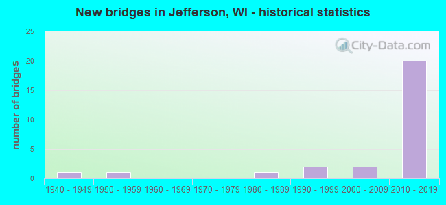
- New bridges - historical statistics
- 11940-1949
- 11950-1959
- 11980-1989
- 21990-1999
- 22000-2009
- 202010-2019


- Bridge Condition - Deck
- 5.9%Very good
- 82.4%Good
- 5.9%Satisfactory
- 5.9%Fair

- Bridge Condition - Superstructure
- 70.6%Very good
- 23.5%Good
- 5.9%Fair

- Bridge Condition - Substructure
- 64.7%Very good
- 23.5%Good
- 11.8%Fair

- Bridge Condition - Channel
- 57.1%Very good
- 42.9%Good
Find on map >> Show street view
Structure Number: B280011, Location: 3.9M N JCT CTH K TO N (Lat: 42.996317, Lng: -88.807328), Route carried "on" structure: State highway 26, Year Built: 1958, Status: Open, Structure Length: 12.05m (39.53ft), Average Daily Traffic: 17,400 (year 2019), Truck Traffic: 3%, Average Future Daily Traffic: 19,650 (year 2039), Design Load: HS 20, Features Intersected: ROCK RIVER
Minimum Vertical Clearance: 30+ m (98+ ft), Kilometerpoint: 0.000, Lanes on structure: 2, Base Highway Network: Yes, Owner: State Highway Agency, Approaching Roadway Width: 14.6m (47.9ft), Skew: 3 degrees, Material/Design: Steel continuous, Design/Construction: Stringer/Multi-beam, Number Of Spans In Main Unit: 5, Length of Maximum Span: 25.9m (85.0ft), Curb or Sidewalk Widths: Left: 2.0m (6.6ft), Right: 2.0m (6.6ft), Curb-To-Curb Width: 9.1m (29.9ft), Out-to-Out Width: 12.8m (42.0ft)
Condition: Deck: Fair, Superstructure: Good, Substructure: Fair, Channel: Very good, Operating Rating: 41.0 metric tons, Method Used To Determine Operating Rating: Load Factor (LF), Inventory Rating: 24.3 metric tons, Method Used To Determine Inventory Rating: Load Factor (LF), Structural Evaluation: Somewhat better than minimum adequacy, Deck Geometry: Meets minimum limits, Waterway Adequacy: Equal to present desirable criteria, Approach Roadway Alignment: Equal to present desirable criteria, Designated Inspection Frequency: Every 24 months, Underwater Inspection Frequency: Every 60 months, Inspection Date: July 2020, Underwater Inspection Date: September 2018, Deck Structure Type: Concrete Cast-file-Place, Wearing Surface/Protective System: Wearing Surface: Low Slump Concrete
Find on map >> Show street view
Structure Number: B280062, Location: 0.3M S JCT USH 18 (Lat: 43.000861, Lng: -88.812611), Route carried "on" structure: City street , Year Built: 1988, Status: Open, Structure Length: 7.67m (25.16ft), Average Daily Traffic: 5,267 (year 2019), Average Future Daily Traffic: 5,793 (year 2039), Design Load: HS 20, Features Intersected: CRAWFISH RIVER, Facility Carried by Structure: LRD WISCONSIN DR
Minimum Vertical Clearance: 30+ m (98+ ft), Kilometerpoint: 0.000, Lanes on structure: 2, Owner: City or Municipal Highway Agency, Approaching Roadway Width: 11.0m (36.1ft), Skew: 2 degrees, Material/Design: Prestressed concrete continuous, Design/Construction: Stringer/Multi-beam, Number Of Spans In Main Unit: 4, Length of Maximum Span: 18.9m (62.0ft), Curb or Sidewalk Widths: Left: 2.0m (6.6ft), Right: 2.0m (6.6ft), Curb-To-Curb Width: 14.6m (47.9ft), Out-to-Out Width: 14.6m (47.9ft)
Condition: Deck: Good, Superstructure: Good, Substructure: Good, Channel: Good, Operating Rating: 62.1 metric tons, Method Used To Determine Operating Rating: Load Factor (LF), Inventory Rating: 38.9 metric tons, Method Used To Determine Inventory Rating: Load Factor (LF), Structural Evaluation: Better than present minimum criteria, Deck Geometry: Superior to present desirable criteria, Waterway Adequacy: Equal to present desirable criteria, Approach Roadway Alignment: Equal to present desirable criteria, Designated Inspection Frequency: Every 48 months, Underwater Inspection Frequency: Every 60 months, Inspection Date: July 2020, Underwater Inspection Date: August 2018, Deck Structure Type: Concrete Cast-file-Place, Wearing Surface/Protective System: Wearing Surface: Monolithic Concrete, Deck Protection: Epoxy Coated Reinforcing
Find on map >> Show street view
Structure Number: B280089, Location: 2.2M E JCT STH 89 TO N (Lat: 43.005314, Lng: -88.810392), Route carried "on" structure: US 18, Year Built: 1998, Status: Open, Structure Length: 20.90m (68.57ft), Average Daily Traffic: 8,400 (year 2019), Truck Traffic: 3%, Average Future Daily Traffic: 10,770 (year 2039), Design Load: HS 20, Features Intersected: ROCK RIVER
Minimum Vertical Clearance: 30+ m (98+ ft), Kilometerpoint: 0.000, Lanes on structure: 2, Owner: State Highway Agency, Approaching Roadway Width: 18.9m (62.0ft), Material/Design: Concrete continuous, Design/Construction: Slab, Number Of Spans In Main Unit: 4, Number Of Approach Spans: 4, Length of Maximum Span: 36.9m (121.1ft), Curb or Sidewalk Widths: Left: 2.0m (6.6ft), Right: 2.0m (6.6ft), Curb-To-Curb Width: 14.6m (47.9ft), Out-to-Out Width: 18.9m (62.0ft)
Condition: Deck: Good, Superstructure: Good, Substructure: Good, Channel: Very good, Operating Rating: 67.0 metric tons, Method Used To Determine Operating Rating: Load Factor (LF), Inventory Rating: 34.0 metric tons, Method Used To Determine Inventory Rating: Load Factor (LF), Structural Evaluation: Better than present minimum criteria, Deck Geometry: Superior to present desirable criteria, Underclear: Equal to present minimum criteria, Waterway Adequacy: Equal to present desirable criteria, Approach Roadway Alignment: Equal to present desirable criteria, Designated Inspection Frequency: Every 48 months, Underwater Inspection Frequency: Every 72 months, Inspection Date: May 2020, Underwater Inspection Date: September 2020, Deck Structure Type: Concrete Cast-file-Place, Wearing Surface/Protective System: Wearing Surface: Epoxy Overlay, Deck Protection: Epoxy Coated Reinforcing
Find on map >> Show street view
Structure Number: B280095, Location: CITY OF JEFFERSON (Lat: 43.012306, Lng: -88.813722), Route carried "on" structure: City street , Year Built: 1998, Status: Open, Structure Length: 12.58m (41.27ft), Average Daily Traffic: 2,354 (year 2019), Truck Traffic: 4%, Average Future Daily Traffic: 2,589 (year 2039), Design Load: HS 20, Features Intersected: ROCK RIVER, Facility Carried by Structure: LRD WEST PUERNER S
Minimum Vertical Clearance: 30+ m (98+ ft), Kilometerpoint: 0.000, Lanes on structure: 2, Owner: City or Municipal Highway Agency, Approaching Roadway Width: 11.9m (39.0ft), Skew: 2 degrees, Material/Design: Prestressed concrete, Design/Construction: Stringer/Multi-beam, Number Of Spans In Main Unit: 4, Length of Maximum Span: 31.3m (102.7ft), Curb or Sidewalk Widths: Left: 1.5m (4.9ft), Right: 2.0m (6.6ft), Curb-To-Curb Width: 10.8m (35.4ft), Out-to-Out Width: 14.4m (47.2ft)
Condition: Deck: Good, Superstructure: Very good, Substructure: Good, Channel: Very good, Operating Rating: 42.5 metric tons, Method Used To Determine Operating Rating: Load Factor (LF), Inventory Rating: 35.6 metric tons, Method Used To Determine Inventory Rating: Load Factor (LF), Structural Evaluation: Better than present minimum criteria, Deck Geometry: Somewhat better than minimum adequacy, Waterway Adequacy: Equal to present desirable criteria, Approach Roadway Alignment: Equal to present desirable criteria, Designated Inspection Frequency: Every 48 months, Underwater Inspection Frequency: Every 72 months, Inspection Date: July 2020, Underwater Inspection Date: August 2018, Deck Structure Type: Concrete Cast-file-Place, Wearing Surface/Protective System: Wearing Surface: Monolithic Concrete, Deck Protection: Epoxy Coated Reinforcing
Find on map >> Show street view
Structure Number: B28014, Location: 2.1 MI N JUNC STH 89 (Lat: 42.976622, Lng: -88.822767), Route carried "on" structure: State highway 26, Year Built: 2010, Status: Open, Structure Length: 5.70m (18.70ft), Average Daily Traffic: 10,100 (year 2019), Average Future Daily Traffic: 10,100 (year 2039), Design Load: HS 25 or greater, Features Intersected: LRD BUS STH 26
Minimum Vertical Clearance: 30+ m (98+ ft), Kilometerpoint: 0.000, Lanes on structure: 2, Lanes under structure: 4, Base Highway Network: Yes, Owner: State Highway Agency, Approaching Roadway Width: 12.2m (40.0ft), Material/Design: Prestressed concrete continuous, Design/Construction: Stringer/Multi-beam, Number Of Spans In Main Unit: 2, Length of Maximum Span: 28.7m (94.2ft), Curb-To-Curb Width: 12.2m (40.0ft), Out-to-Out Width: 13.0m (42.7ft)
Condition: Deck: Good, Superstructure: Very good, Substructure: Very good, Inventory Rating: 50.2 metric tons, Method Used To Determine Inventory Rating: Load Factor (LF), Structural Evaluation: Equal to present desirable criteria, Deck Geometry: Better than present minimum criteria, Underclear: Somewhat better than minimum adequacy, Approach Roadway Alignment: Equal to present desirable criteria, Designated Inspection Frequency: Every 48 months, Inspection Date: November 2020, Deck Structure Type: Concrete Cast-file-Place, Wearing Surface/Protective System: Wearing Surface: Monolithic Concrete, Deck Protection: Epoxy Coated Reinforcing
Find on map >> Show street view
Structure Number: B280141, Location: 2.1 MI S OF JUNC USH 18 (Lat: 42.976883, Lng: -88.823347), Route carried "on" structure: State highway 26, Year Built: 2010, Status: Open, Structure Length: 5.52m (18.11ft), Average Daily Traffic: 10,100 (year 2019), Average Future Daily Traffic: 10,100 (year 2039), Design Load: HS 25 or greater, Features Intersected: LRD S MAIN STREET
Minimum Vertical Clearance: 30+ m (98+ ft), Kilometerpoint: 0.000, Lanes on structure: 2, Lanes under structure: 4, Base Highway Network: Yes, Owner: State Highway Agency, Approaching Roadway Width: 12.2m (40.0ft), Material/Design: Prestressed concrete continuous, Design/Construction: Stringer/Multi-beam, Number Of Spans In Main Unit: 2, Length of Maximum Span: 27.7m (90.9ft), Curb-To-Curb Width: 12.2m (40.0ft), Out-to-Out Width: 13.0m (42.7ft)
Condition: Deck: Good, Superstructure: Very good, Substructure: Good, Operating Rating: 90.0 metric tons, Method Used To Determine Operating Rating: Load Factor (LF), Inventory Rating: 43.7 metric tons, Method Used To Determine Inventory Rating: Load Factor (LF), Structural Evaluation: Better than present minimum criteria, Deck Geometry: Better than present minimum criteria, Underclear: Somewhat better than minimum adequacy, Approach Roadway Alignment: Equal to present desirable criteria, Designated Inspection Frequency: Every 48 months, Inspection Date: June 2020, Deck Structure Type: Concrete Cast-file-Place, Wearing Surface/Protective System: Wearing Surface: Monolithic Concrete, Deck Protection: Epoxy Coated Reinforcing
Find on map >> Show street view
Structure Number: B280142, Location: 1.5 MI S OF JUNC USH 18 (Lat: 42.985531, Lng: -88.830386), Route carried "on" structure: County highway , Year Built: 2010, Status: Open, Structure Length: 7.94m (26.05ft), Average Daily Traffic: 3,300 (year 2019), Average Future Daily Traffic: 4,600 (year 2039), Design Load: HS 20, Features Intersected: STH 26, Facility Carried by Structure: CTH W
Minimum Vertical Clearance: 30+ m (98+ ft), Kilometerpoint: 0.000, Lanes on structure: 2, Lanes under structure: 4, Owner: State Highway Agency, Approaching Roadway Width: 11.0m (36.1ft), Skew: 3 degrees, Material/Design: Prestressed concrete continuous, Design/Construction: Stringer/Multi-beam, Number Of Spans In Main Unit: 2, Length of Maximum Span: 40.8m (133.9ft), Curb or Sidewalk Widths: Left: 2.0m (6.6ft), Right: 2.0m (6.6ft), Curb-To-Curb Width: 11.0m (36.1ft), Out-to-Out Width: 15.2m (49.9ft)
Condition: Deck: Good, Superstructure: Good, Substructure: Very good, Operating Rating: 78.4 metric tons, Method Used To Determine Operating Rating: Load Factor (LF), Inventory Rating: 43.7 metric tons, Method Used To Determine Inventory Rating: Load Factor (LF), Structural Evaluation: Better than present minimum criteria, Deck Geometry: Somewhat better than minimum adequacy, Underclear: Meets minimum limits, Approach Roadway Alignment: Equal to present desirable criteria, Designated Inspection Frequency: Every 48 months, Inspection Date: June 2020, Deck Structure Type: Concrete Cast-file-Place, Wearing Surface/Protective System: Wearing Surface: Monolithic Concrete, Deck Protection: Epoxy Coated Reinforcing
Find on map >> Show street view
Structure Number: B280143, Location: 0.8 MI S JCT USH 18 (Lat: 42.993775, Lng: -88.834767), Route carried "on" structure: County highway , Year Built: 2010, Status: Open, Structure Length: 6.52m (21.39ft), Average Daily Traffic: 1,750 (year 2019), Average Future Daily Traffic: 1,750 (year 2039), Design Load: HS 25 or greater, Features Intersected: STH 26, Facility Carried by Structure: CTH J
Minimum Vertical Clearance: 30+ m (98+ ft), Kilometerpoint: 0.000, Lanes on structure: 2, Lanes under structure: 4, Owner: State Highway Agency, Approaching Roadway Width: 11.0m (36.1ft), Material/Design: Prestressed concrete continuous, Design/Construction: Stringer/Multi-beam, Number Of Spans In Main Unit: 2, Length of Maximum Span: 32.0m (105.0ft), Curb-To-Curb Width: 11.0m (36.1ft), Out-to-Out Width: 13.4m (44.0ft)
Condition: Deck: Good, Superstructure: Very good, Substructure: Very good, Operating Rating: 50.6 metric tons, Method Used To Determine Operating Rating: Load Factor (LF), Inventory Rating: 30.8 metric tons, Method Used To Determine Inventory Rating: Load Factor (LF), Structural Evaluation: Better than present minimum criteria, Deck Geometry: Equal to present minimum criteria, Underclear: Equal to present minimum criteria, Approach Roadway Alignment: Equal to present desirable criteria, Designated Inspection Frequency: Every 24 months, Inspection Date: June 2020, Deck Structure Type: Concrete Cast-file-Place, Wearing Surface/Protective System: Wearing Surface: Monolithic Concrete, Deck Protection: Epoxy Coated Reinforcing
Find on map >> Show street view
Structure Number: B280144, Location: AT USH 18 (Lat: 43.006011, Lng: -88.834419), Route carried "on" structure: State highway 26, Year Built: 2010, Status: Open, Structure Length: 5.61m (18.41ft), Average Daily Traffic: 10,100 (year 2019), Average Future Daily Traffic: 10,100 (year 2039), Design Load: HS 25 or greater, Features Intersected: USH 18
Minimum Vertical Clearance: 30+ m (98+ ft), Kilometerpoint: 0.000, Lanes on structure: 2, Lanes under structure: 4, Base Highway Network: Yes, Owner: State Highway Agency, Approaching Roadway Width: 12.2m (40.0ft), Material/Design: Prestressed concrete continuous, Design/Construction: Stringer/Multi-beam, Number Of Spans In Main Unit: 2, Length of Maximum Span: 27.4m (89.9ft), Curb-To-Curb Width: 12.2m (40.0ft), Out-to-Out Width: 13.1m (43.0ft)
Condition: Deck: Good, Superstructure: Very good, Substructure: Very good, Operating Rating: 94.7 metric tons, Method Used To Determine Operating Rating: Load Factor (LF), Inventory Rating: 43.7 metric tons, Method Used To Determine Inventory Rating: Load Factor (LF), Structural Evaluation: Equal to present desirable criteria, Deck Geometry: Better than present minimum criteria, Underclear: Equal to present minimum criteria, Approach Roadway Alignment: Equal to present desirable criteria, Designated Inspection Frequency: Every 48 months, Inspection Date: June 2020, Deck Structure Type: Concrete Cast-file-Place, Wearing Surface/Protective System: Wearing Surface: Monolithic Concrete, Deck Protection: Epoxy Coated Reinforcing
Find on map >> Show street view
Structure Number: B280145, Location: AT USH 18 (Lat: 43.006467, Lng: -88.834753), Route carried "on" structure: State highway 26, Year Built: 2010, Status: Open, Structure Length: 5.79m (19.00ft), Average Daily Traffic: 10,100 (year 2019), Average Future Daily Traffic: 10,100 (year 2039), Design Load: HS 25 or greater, Features Intersected: USH 18
Minimum Vertical Clearance: 30+ m (98+ ft), Kilometerpoint: 0.000, Lanes on structure: 2, Lanes under structure: 4, Base Highway Network: Yes, Owner: State Highway Agency, Approaching Roadway Width: 12.2m (40.0ft), Material/Design: Prestressed concrete continuous, Design/Construction: Stringer/Multi-beam, Number Of Spans In Main Unit: 2, Length of Maximum Span: 28.3m (92.8ft), Curb-To-Curb Width: 12.2m (40.0ft), Out-to-Out Width: 13.1m (43.0ft)
Condition: Deck: Good, Superstructure: Very good, Substructure: Very good, Operating Rating: 94.7 metric tons, Method Used To Determine Operating Rating: Load Factor (LF), Inventory Rating: 43.7 metric tons, Method Used To Determine Inventory Rating: Load Factor (LF), Structural Evaluation: Equal to present desirable criteria, Deck Geometry: Better than present minimum criteria, Underclear: Equal to present minimum criteria, Approach Roadway Alignment: Equal to present desirable criteria, Designated Inspection Frequency: Every 48 months, Inspection Date: June 2020, Deck Structure Type: Concrete Cast-file-Place, Wearing Surface/Protective System: Wearing Surface: Monolithic Concrete, Deck Protection: Epoxy Coated Reinforcing
Find on map >> Show street view
Structure Number: B280146, Location: 0.2 M N JCT USH 18 (Lat: 43.008722, Lng: -88.833139), Route carried "on" structure: State highway 26, Year Built: 2009, Status: Open, Structure Length: 12.48m (40.94ft), Average Daily Traffic: 20,200 (year 2019), Average Future Daily Traffic: 20,200 (year 2039), Design Load: HL 93, Features Intersected: CRAWFISH R
Minimum Vertical Clearance: 30+ m (98+ ft), Kilometerpoint: 0.000, Lanes on structure: 3, Base Highway Network: Yes, Owner: State Highway Agency, Approaching Roadway Width: 15.2m (49.9ft), Material/Design: Prestressed concrete continuous, Design/Construction: Stringer/Multi-beam, Number Of Spans In Main Unit: 3, Length of Maximum Span: 47.2m (154.9ft), Curb-To-Curb Width: 15.2m (49.9ft), Out-to-Out Width: 16.0m (52.5ft)
Condition: Deck: Very good, Superstructure: Very good, Substructure: Very good, Channel: Good, Operating Rating: 44.7 metric tons, Method Used To Determine Operating Rating: Load and Resistance Factor Rating (LRFR) rating reported by rating factor(RF) method using HL-93 loadings, Inventory Rating: 34.3 metric tons, Method Used To Determine Inventory Rating: Load and Resistance Factor Rating (LRFR) rating reported by rating factor(RF) method using HL-93 loadings, Structural Evaluation: Equal to present desirable criteria, Deck Geometry: Equal to present minimum criteria, Waterway Adequacy: Superior to present desirable criteria, Approach Roadway Alignment: Equal to present desirable criteria, Designated Inspection Frequency: Every 48 months, Underwater Inspection Frequency: Every 72 months, Inspection Date: May 2020, Underwater Inspection Date: May 2019, Deck Structure Type: Concrete Cast-file-Place, Wearing Surface/Protective System: Wearing Surface: Epoxy Overlay, Deck Protection: Epoxy Coated Reinforcing
Find on map >> Show street view
Structure Number: B280147, Location: 0.2 M N JCT USH 18 (Lat: 43.009819, Lng: -88.832750), Route carried "on" structure: State highway 26, Year Built: 2009, Status: Open, Structure Length: 12.48m (40.94ft), Average Daily Traffic: 20,200 (year 2019), Average Future Daily Traffic: 20,200 (year 2039), Design Load: HL 93, Features Intersected: CRAWFISH R
Minimum Vertical Clearance: 30+ m (98+ ft), Kilometerpoint: 0.000, Lanes on structure: 3, Base Highway Network: Yes, Owner: State Highway Agency, Approaching Roadway Width: 15.2m (49.9ft), Material/Design: Prestressed concrete continuous, Design/Construction: Stringer/Multi-beam, Number Of Spans In Main Unit: 3, Length of Maximum Span: 47.2m (154.9ft), Curb-To-Curb Width: 15.2m (49.9ft), Out-to-Out Width: 16.0m (52.5ft)
Condition: Deck: Good, Superstructure: Very good, Substructure: Very good, Channel: Good, Operating Rating: 44.7 metric tons, Method Used To Determine Operating Rating: Load and Resistance Factor Rating (LRFR) rating reported by rating factor(RF) method using HL-93 loadings, Inventory Rating: 34.3 metric tons, Method Used To Determine Inventory Rating: Load and Resistance Factor Rating (LRFR) rating reported by rating factor(RF) method using HL-93 loadings, Structural Evaluation: Equal to present desirable criteria, Deck Geometry: Equal to present minimum criteria, Waterway Adequacy: Superior to present desirable criteria, Approach Roadway Alignment: Equal to present desirable criteria, Designated Inspection Frequency: Every 48 months, Underwater Inspection Frequency: Every 72 months, Inspection Date: May 2020, Underwater Inspection Date: May 2019, Deck Structure Type: Concrete Cast-file-Place, Wearing Surface/Protective System: Wearing Surface: Monolithic Concrete, Deck Protection: Epoxy Coated Reinforcing
Find on map >> Show street view
Structure Number: B280148, Location: 0.8 MI. N OF USH 18 (Lat: 43.016958, Lng: -88.828183), Route carried "on" structure: State highway 26, Year Built: 2010, Status: Open, Structure Length: 3.47m (11.38ft), Average Daily Traffic: 14,700 (year 2019), Average Future Daily Traffic: 20,200 (year 2039), Design Load: HS 25 or greater, Features Intersected: LRD POPP RD
Minimum Vertical Clearance: 30+ m (98+ ft), Kilometerpoint: 0.000, Lanes on structure: 2, Lanes under structure: 2, Base Highway Network: Yes, Owner: State Highway Agency, Approaching Roadway Width: 12.5m (41.0ft), Material/Design: Prestressed concrete, Design/Construction: Stringer/Multi-beam, Number Of Spans In Main Unit: 1, Length of Maximum Span: 33.5m (109.9ft), Curb-To-Curb Width: 12.2m (40.0ft), Out-to-Out Width: 13.0m (42.7ft)
Condition: Deck: Good, Superstructure: Very good, Substructure: Very good, Inventory Rating: 43.7 metric tons, Method Used To Determine Inventory Rating: Load Factor (LF), Structural Evaluation: Equal to present desirable criteria, Deck Geometry: Better than present minimum criteria, Underclear: Equal to present minimum criteria, Approach Roadway Alignment: Equal to present desirable criteria, Designated Inspection Frequency: Every 48 months, Inspection Date: July 2020, Deck Structure Type: Concrete Cast-file-Place, Wearing Surface/Protective System: Wearing Surface: Monolithic Concrete, Deck Protection: Epoxy Coated Reinforcing
Find on map >> Show street view
Structure Number: B280149, Location: 6.2 MI. S OF IH 94 (Lat: 43.017236, Lng: -88.828461), Route carried "on" structure: State highway 26, Year Built: 2010, Status: Open, Structure Length: 3.47m (11.38ft), Average Daily Traffic: 14,700 (year 2019), Average Future Daily Traffic: 20,200 (year 2039), Design Load: HS 25 or greater, Features Intersected: LRD POPP RD
Minimum Vertical Clearance: 30+ m (98+ ft), Kilometerpoint: 0.000, Lanes on structure: 2, Lanes under structure: 2, Base Highway Network: Yes, Owner: State Highway Agency, Approaching Roadway Width: 12.5m (41.0ft), Material/Design: Prestressed concrete, Design/Construction: Stringer/Multi-beam, Number Of Spans In Main Unit: 1, Length of Maximum Span: 33.5m (109.9ft), Curb-To-Curb Width: 12.2m (40.0ft), Out-to-Out Width: 13.0m (42.7ft)
Condition: Deck: Good, Superstructure: Very good, Substructure: Very good, Inventory Rating: 43.7 metric tons, Method Used To Determine Inventory Rating: Load Factor (LF), Structural Evaluation: Equal to present desirable criteria, Deck Geometry: Better than present minimum criteria, Underclear: Equal to present minimum criteria, Approach Roadway Alignment: Equal to present desirable criteria, Designated Inspection Frequency: Every 48 months, Inspection Date: July 2020, Deck Structure Type: Concrete Cast-file-Place, Wearing Surface/Protective System: Wearing Surface: Monolithic Concrete, Membrane: Epoxy, Deck Protection: Epoxy Coated Reinforcing
Find on map >> Show street view
Structure Number: B280151, Location: 5.2 MI. S OF IH 94 (Lat: 43.029939, Lng: -88.816953), Route carried "on" structure: State highway 26, Year Built: 2010, Status: Open, Structure Length: 4.07m (13.35ft), Average Daily Traffic: 10,100 (year 2019), Average Future Daily Traffic: 10,100 (year 2039), Design Load: HS 25 or greater, Features Intersected: CTH N
Minimum Vertical Clearance: 30+ m (98+ ft), Kilometerpoint: 0.000, Lanes on structure: 2, Lanes under structure: 2, Base Highway Network: Yes, Owner: State Highway Agency, Approaching Roadway Width: 12.2m (40.0ft), Skew: 3 degrees, Material/Design: Prestressed concrete, Design/Construction: Stringer/Multi-beam, Number Of Spans In Main Unit: 1, Length of Maximum Span: 39.3m (128.9ft), Curb-To-Curb Width: 12.2m (40.0ft), Out-to-Out Width: 13.1m (43.0ft)
Condition: Deck: Good, Superstructure: Very good, Substructure: Very good, Inventory Rating: 47.0 metric tons, Method Used To Determine Inventory Rating: Load Factor (LF), Structural Evaluation: Equal to present desirable criteria, Deck Geometry: Better than present minimum criteria, Underclear: Equal to present minimum criteria, Approach Roadway Alignment: Equal to present desirable criteria, Designated Inspection Frequency: Every 48 months, Inspection Date: July 2020, Deck Structure Type: Concrete Cast-file-Place, Wearing Surface/Protective System: Wearing Surface: Monolithic Concrete, Deck Protection: Epoxy Coated Reinforcing
Find on map >> Show street view
Structure Number: B280155, Location: 3.02 MI N OF USH 18 (Lat: 43.038950, Lng: -88.804000), Route carried "on" structure: City street , Year Built: 2010, Status: Open, Structure Length: 7.48m (24.54ft), Average Daily Traffic: 1 (year 2019), Average Future Daily Traffic: 1 (year 2039), Design Load: HS 25 or greater, Features Intersected: STH 26, Facility Carried by Structure: LRD VALERO WAY
Minimum Vertical Clearance: 30+ m (98+ ft), Kilometerpoint: 0.000, Lanes on structure: 2, Lanes under structure: 5, Owner: State Highway Agency, Approaching Roadway Width: 11.0m (36.1ft), Skew: 1 degrees, Material/Design: Prestressed concrete continuous, Design/Construction: Stringer/Multi-beam, Number Of Spans In Main Unit: 2, Length of Maximum Span: 38.4m (126.0ft), Curb-To-Curb Width: 11.0m (36.1ft), Out-to-Out Width: 15.8m (51.8ft)
Condition: Deck: Good, Superstructure: Very good, Substructure: Very good, Operating Rating: 93.1 metric tons, Method Used To Determine Operating Rating: Load Factor (LF), Inventory Rating: 34.0 metric tons, Method Used To Determine Inventory Rating: Load Factor (LF), Structural Evaluation: Equal to present desirable criteria, Deck Geometry: Superior to present desirable criteria, Underclear: Meets minimum limits, Approach Roadway Alignment: Equal to present desirable criteria, Designated Inspection Frequency: Every 48 months, Inspection Date: July 2020, Deck Structure Type: Concrete Cast-file-Place, Wearing Surface/Protective System: Wearing Surface: Monolithic Concrete, Deck Protection: Epoxy Coated Reinforcing
Find on map >> Show street view
Structure Number: B280666, Location: 1.2M E JCT STH 89 TO N (Lat: 43.006161, Lng: -88.830786), Route carried "on" structure: US 18, Year Built: 1940, Year Reconstructed: 1988, Status: Open, Structure Length: 6.40m (21.00ft), Average Daily Traffic: 6,000 (year 2019), Truck Traffic: 4%, Average Future Daily Traffic: 7,510 (year 2039), Design Load: H 20, Features Intersected: CRAWFISH RIVER
Minimum Vertical Clearance: 30+ m (98+ ft), Kilometerpoint: 0.000, Lanes on structure: 2, Owner: State Highway Agency, Approaching Roadway Width: 9.1m (29.9ft), Material/Design: Steel, Design/Construction: Stringer/Multi-beam, Number Of Spans In Main Unit: 3, Length of Maximum Span: 21.1m (69.2ft), Curb-To-Curb Width: 11.1m (36.4ft), Out-to-Out Width: 12.0m (39.4ft)
Condition: Deck: Satisfactory, Superstructure: Fair, Substructure: Fair, Channel: Very good, Operating Rating: 39.2 metric tons, Method Used To Determine Operating Rating: Load Factor (LF), Inventory Rating: 22.7 metric tons, Method Used To Determine Inventory Rating: Load Factor (LF), Structural Evaluation: Somewhat better than minimum adequacy, Deck Geometry: Meets minimum limits, Waterway Adequacy: Equal to present desirable criteria, Approach Roadway Alignment: Equal to present desirable criteria, Designated Inspection Frequency: Every 24 months, Underwater Inspection Frequency: Every 60 months, Inspection Date: April 2020, Underwater Inspection Date: September 2020, Deck Structure Type: Concrete Cast-file-Place, Wearing Surface/Protective System: Wearing Surface: Integral Concrete, Deck Protection: Epoxy Coated Reinforcing
Find on map >> Show street view
Structure Number: B28014, Location: AT INTERSECTION (Lat: 42.976622, Lng: -88.822767), Route carried "under" structure: City street , Year Built: 2010, Structure Length: 0. m, Average Daily Traffic: 10,000 (year 2019), Features Intersected: LRD BUS STH 26, Facility Carried by Structure: STH 26 NB
Minimum Vertical Clearance: 5.62m (18.44ft), Kilometerpoint: 0.000, Lanes on structure: 2, Lanes under structure: 4, Material/Design: Prestressed concrete continuous, Design/Construction: Stringer/Multi-beam, Length of Maximum Span: 28.7m (94.2ft)
Find on map >> Show street view
Structure Number: B280142, Location: AT INTERSECTION (Lat: 42.985531, Lng: -88.830386), Route carried "under" structure: State highway 26, Year Built: 2010, Structure Length: 0. m, Average Daily Traffic: 14,700 (year 2019), Features Intersected: STH 26, Facility Carried by Structure: CTH W
Minimum Vertical Clearance: 5.14m (16.86ft), Kilometerpoint: 0.000, Lanes on structure: 2, Lanes under structure: 4, Material/Design: Prestressed concrete continuous, Design/Construction: Stringer/Multi-beam, Length of Maximum Span: 40.8m (133.9ft)
Find on map >> Show street view
Structure Number: B280143, Location: AT INTERSECTION (Lat: 42.993775, Lng: -88.834767), Route carried "under" structure: State highway 26, Year Built: 2010, Structure Length: 0. m, Average Daily Traffic: 20,200 (year 2019), Features Intersected: STH 26, Facility Carried by Structure: CTH J
Minimum Vertical Clearance: 5.15m (16.90ft), Kilometerpoint: 0.000, Lanes on structure: 2, Lanes under structure: 4, Material/Design: Prestressed concrete continuous, Design/Construction: Stringer/Multi-beam, Length of Maximum Span: 32.0m (105.0ft)
Find on map >> Show street view
Structure Number: B280144, Location: AT INTERSECTION (Lat: 43.006011, Lng: -88.834419), Route carried "under" structure: US 18, Year Built: 2010, Structure Length: 0. m, Average Daily Traffic: 12,400 (year 2019), Features Intersected: USH 18, Facility Carried by Structure: STH 26 NB
Minimum Vertical Clearance: 5.15m (16.90ft), Kilometerpoint: 0.000, Lanes on structure: 2, Lanes under structure: 4, Material/Design: Prestressed concrete continuous, Design/Construction: Stringer/Multi-beam, Length of Maximum Span: 27.4m (89.9ft)
Find on map >> Show street view
Structure Number: B280145, Location: AT INTERSECTION (Lat: 43.006467, Lng: -88.834753), Route carried "under" structure: US 18, Year Built: 2010, Structure Length: 0. m, Average Daily Traffic: 12,400 (year 2019), Features Intersected: USH 18, Facility Carried by Structure: STH 26 SB
Minimum Vertical Clearance: 5.54m (18.18ft), Kilometerpoint: 0.000, Lanes on structure: 2, Lanes under structure: 4, Material/Design: Prestressed concrete continuous, Design/Construction: Stringer/Multi-beam, Length of Maximum Span: 28.3m (92.8ft)
Find on map >> Show street view
Structure Number: B280148, Location: AT INTERSECTION (Lat: 43.016958, Lng: -88.828183), Route carried "under" structure: City street , Year Built: 2010, Structure Length: 0. m, Average Daily Traffic: 150 (year 2019), Features Intersected: LRD POPP RD, Facility Carried by Structure: STH 26 NB
Minimum Vertical Clearance: 4.70m (15.42ft), Kilometerpoint: 0.000, Lanes on structure: 2, Lanes under structure: 2, Material/Design: Prestressed concrete, Design/Construction: Stringer/Multi-beam, Length of Maximum Span: 33.5m (109.9ft)
Find on map >> Show street view
Structure Number: B280149, Location: AT INTERSECTION (Lat: 43.017236, Lng: -88.828461), Route carried "under" structure: City street , Year Built: 2010, Structure Length: 0. m, Average Daily Traffic: 150 (year 2019), Features Intersected: LRD POPP RD, Facility Carried by Structure: STH 26 SB
Minimum Vertical Clearance: 4.67m (15.32ft), Kilometerpoint: 0.000, Lanes on structure: 2, Lanes under structure: 2, Material/Design: Prestressed concrete, Design/Construction: Stringer/Multi-beam, Length of Maximum Span: 33.5m (109.9ft)
Find on map >> Show street view
Structure Number: B28015, Location: AT INTERSECTION (Lat: 43.029475, Lng: -88.817817), Route carried "under" structure: County highway , Year Built: 2010, Structure Length: 0. m, Average Daily Traffic: 1,000 (year 2019), Features Intersected: CTH N, Facility Carried by Structure: STH 26 NB
Minimum Vertical Clearance: 4.88m (16.01ft), Kilometerpoint: 0.000, Lanes on structure: 2, Lanes under structure: 2, Material/Design: Prestressed concrete, Design/Construction: Stringer/Multi-beam, Length of Maximum Span: 40.8m (133.9ft)
Find on map >> Show street view
Structure Number: B280151, Location: AT INTERSECTION (Lat: 43.029939, Lng: -88.816953), Route carried "under" structure: County highway , Year Built: 2010, Structure Length: 0. m, Average Daily Traffic: 1,000 (year 2019), Features Intersected: CTH N, Facility Carried by Structure: STH 26 SB
Minimum Vertical Clearance: 4.67m (15.32ft), Kilometerpoint: 0.000, Lanes on structure: 2, Lanes under structure: 2, Material/Design: Prestressed concrete, Design/Construction: Stringer/Multi-beam, Length of Maximum Span: 39.3m (128.9ft)
Find on map >> Show street view
Structure Number: B280155, Location: AT INTERSECTION (Lat: 43.038950, Lng: -88.804000), Route carried "under" structure: State highway 26, Year Built: 2010, Structure Length: 0. m, Average Daily Traffic: 12,400 (year 2019), Features Intersected: STH 26, Facility Carried by Structure: LRD VALERO WAY
Minimum Vertical Clearance: 5.31m (17.42ft), Kilometerpoint: 0.000, Lanes on structure: 2, Lanes under structure: 5, Material/Design: Prestressed concrete continuous, Design/Construction: Stringer/Multi-beam, Length of Maximum Span: 38.4m (126.0ft)