Bridge Statistics for Jemison, Alabama (AL)
Condition, Traffic, Stress, Structural Evaluation, Project Costs
- National Bridge Inventory (NBI) Statistics
- 21Number of bridges
- 167ft / 51.3mTotal length
- $21,194,000Total costs
- 210,101Total average daily traffic
- 44,814Total average daily truck traffic
- National Bridge Inventory (NBI) Registered Bridges for Jemison
- No street view available for this location
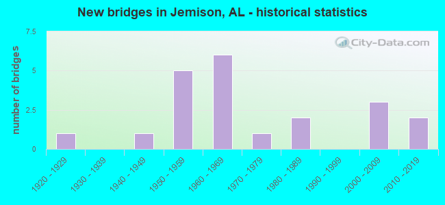
- New bridges - historical statistics
- 11920-1929
- 11940-1949
- 51950-1959
- 61960-1969
- 11970-1979
- 21980-1989
- 32000-2009
- 22010-2019

- Reconstructed bridges - Historical Statistics
- 11980-1989
- 11990-1999


- Bridge Condition - Deck
- 22.2%Excellent
- 11.1%Very good
- 33.3%Good
- 22.2%Satisfactory
- 11.1%Fair

- Bridge Condition - Superstructure
- 33.3%Excellent
- 11.1%Very good
- 22.2%Good
- 22.2%Satisfactory
- 11.1%Fair

- Bridge Condition - Substructure
- 22.2%Excellent
- 11.1%Very good
- 44.4%Good
- 11.1%Satisfactory
- 11.1%Fair

- Bridge Condition - Channel
- 14.3%Very good
- 57.1%Good
- 28.6%Satisfactory

- Bridge Condition - Culverts
- 33.3%Very good
- 22.2%Good
- 33.3%Satisfactory
- 11.1%Fair
Find on map >> Show street view
Structure Number: 253, Location: CR33 .5 E PROVIDENCE CHUR (Lat: 33.023753, Lng: -86.791183), Route carried "on" structure: County highway , Year Built: 1925, Status: Open, Structure Length: 0.67m (2.20ft), Average Daily Traffic: 600 (year 1985), Truck Traffic: 1%, Average Future Daily Traffic: 650 (year 2029), Design Load: HS 20, Features Intersected: WATSON CREEK, Facility Carried by Structure: CR33 OLD HWY 31
Minimum Vertical Clearance: 30+ m (98+ ft), Kilometerpoint: 0.010, Lanes on structure: 2, Owner: County Highway Agency, Approaching Roadway Width: 8.5m (27.9ft), Material/Design: Concrete, Design/Construction: Culvert, Number Of Spans In Main Unit: 2, Length of Maximum Span: 3.0m (9.8ft), Out-to-Out Width: 7.9m (25.9ft)
Condition: Channel: Good, Culverts: Satisfactory, Operating Rating: 50.4 metric tons, Method Used To Determine Operating Rating: Load Factor (LF), Inventory Rating: 33.9 metric tons, Method Used To Determine Inventory Rating: Load Factor (LF), Structural Evaluation: Equal to present minimum criteria, Waterway Adequacy: Better than present minimum criteria, Approach Roadway Alignment: Somewhat better than minimum adequacy, Length Of Structure Improvement: 1.30m (4.27ft), Designated Inspection Frequency: Every 24 months, Inspection Date: October 2020, Bridge Improvement Cost: $218,000, Roadway Improvement Cost: $22,000, Total Project Cost: $240,000 ( Estimate for 2022), Wearing Surface/Protective System: Wearing Surface: Bituminous
Find on map >> Show street view
Structure Number: 253, Location: 2.3 MI N JCT SR 155 (Lat: 33.023067, Lng: -86.764733), Route carried "on" structure: US 31, Year Built: 1941, Status: Open, Structure Length: 2.07m (6.79ft), Average Daily Traffic: 3,770 (year 2016), Truck Traffic: 10%, Average Future Daily Traffic: 4,843 (year 2041), Design Load: H 15, Features Intersected: CLEAR CREEK
Minimum Vertical Clearance: 30+ m (98+ ft), Kilometerpoint: 381.720, Lanes on structure: 2, Base Highway Network: Yes, Owner: State Highway Agency, Approaching Roadway Width: 11.6m (38.1ft), Skew: 4 degrees, Material/Design: Concrete continuous, Design/Construction: Slab, Number Of Spans In Main Unit: 4, Length of Maximum Span: 4.9m (16.1ft), Curb or Sidewalk Widths: Left: 0.4m (1.3ft), Right: 0.4m (1.3ft), Curb-To-Curb Width: 11.4m (37.4ft), Out-to-Out Width: 13.0m (42.7ft)
Condition: Deck: Fair, Superstructure: Fair, Substructure: Fair, Channel: Satisfactory, Operating Rating: 37.6 metric tons, Method Used To Determine Operating Rating: Load Factor (LF), Inventory Rating: 22.6 metric tons, Method Used To Determine Inventory Rating: Load Factor (LF), Structural Evaluation: Somewhat better than minimum adequacy, Deck Geometry: Somewhat better than minimum adequacy, Waterway Adequacy: Better than present minimum criteria, Approach Roadway Alignment: Equal to present desirable criteria, Length Of Structure Improvement: 2.84m (9.32ft), Designated Inspection Frequency: Every 24 months, Inspection Date: January 2022, Bridge Improvement Cost: $818,000, Roadway Improvement Cost: $82,000, Total Project Cost: $900,000 ( Estimate for 2022), Deck Structure Type: Concrete Cast-file-Place
Find on map >> Show street view
Structure Number: 6456, Location: 1.5 MI JCT CO RD 51 (Lat: 32.980000, Lng: -86.688167), Route carried "on" structure: County highway 42, Year Built: 1959, Status: Open, Structure Length: 7.52m (24.67ft), Average Daily Traffic: 300 (year 2008), Truck Traffic: 1%, Average Future Daily Traffic: 400 (year 2028), Design Load: HS 20, Features Intersected: I-65
Minimum Vertical Clearance: 30+ m (98+ ft), Kilometerpoint: 0.000, Lanes on structure: 2, Lanes under structure: 4, Owner: State Highway Agency, Approaching Roadway Width: 9.4m (30.8ft), Material/Design: Concrete continuous, Design/Construction: Tee Beam, Number Of Spans In Main Unit: 4, Length of Maximum Span: 20.7m (67.9ft), Curb or Sidewalk Widths: Left: 0.5m (1.6ft), Right: 0.5m (1.6ft), Curb-To-Curb Width: 8.6m (28.2ft), Out-to-Out Width: 10.1m (33.1ft)
Condition: Deck: Satisfactory, Superstructure: Satisfactory, Substructure: Good, Operating Rating: 54.9 metric tons, Method Used To Determine Operating Rating: Load Factor (LF), Inventory Rating: 32.8 metric tons, Method Used To Determine Inventory Rating: Load Factor (LF), Structural Evaluation: Equal to present minimum criteria, Deck Geometry: Equal to present minimum criteria, Underclear: Equal to present minimum criteria, Approach Roadway Alignment: Equal to present desirable criteria, Length Of Structure Improvement: 8.54m (28.02ft), Designated Inspection Frequency: Every 24 months, Inspection Date: September 2021, Bridge Improvement Cost: $1,933,000, Roadway Improvement Cost: $193,000, Total Project Cost: $2,126,000 ( Estimate for 2022), Deck Structure Type: Concrete Cast-file-Place
Find on map >> Show street view
Structure Number: 6457, Location: 1.5 MI N JCT CO RD 42 (Lat: 32.998567, Lng: -86.701083), Route carried "on" structure: County highway 51, Year Built: 1959, Status: Open, Structure Length: 8.63m (28.31ft), Average Daily Traffic: 350 (year 2008), Truck Traffic: 1%, Average Future Daily Traffic: 500 (year 2028), Design Load: H 20, Features Intersected: I-65
Minimum Vertical Clearance: 30+ m (98+ ft), Kilometerpoint: 0.000, Lanes on structure: 2, Lanes under structure: 4, Owner: State Highway Agency, Approaching Roadway Width: 7.6m (24.9ft), Skew: 3 degrees, Material/Design: Concrete continuous, Design/Construction: Tee Beam, Number Of Spans In Main Unit: 4, Length of Maximum Span: 23.8m (78.1ft), Curb or Sidewalk Widths: Left: 0.5m (1.6ft), Right: 0.5m (1.6ft), Curb-To-Curb Width: 7.3m (24.0ft), Out-to-Out Width: 9.0m (29.5ft)
Condition: Deck: Good, Superstructure: Good, Substructure: Good, Operating Rating: 53.4 metric tons, Method Used To Determine Operating Rating: Allowable Stress (AS), Inventory Rating: 26.2 metric tons, Method Used To Determine Inventory Rating: Allowable Stress (AS), Structural Evaluation: Equal to present minimum criteria, Deck Geometry: Somewhat better than minimum adequacy, Underclear: Equal to present minimum criteria, Approach Roadway Alignment: Somewhat better than minimum adequacy, Length Of Structure Improvement: 9.62m (31.56ft), Designated Inspection Frequency: Every 24 months, Inspection Date: September 2021, Bridge Improvement Cost: $1,912,000, Roadway Improvement Cost: $191,000, Total Project Cost: $2,103,000 ( Estimate for 2022), Deck Structure Type: Concrete Cast-file-Place
Find on map >> Show street view
Structure Number: 6795, Location: 4.7 MI N JCT SR 145 (Lat: 32.944667, Lng: -86.665933), Route carried "on" structure: County highway 48, Year Built: 1960, Status: Open, Structure Length: 11.80m (38.71ft), Average Daily Traffic: 350 (year 2008), Truck Traffic: 1%, Average Future Daily Traffic: 500 (year 2028), Design Load: H 20, Features Intersected: I-65
Minimum Vertical Clearance: 30+ m (98+ ft), Kilometerpoint: 0.000, Lanes on structure: 2, Lanes under structure: 4, Owner: State Highway Agency, Approaching Roadway Width: 7.9m (25.9ft), Skew: 4 degrees, Material/Design: Concrete continuous, Design/Construction: Tee Beam, Number Of Spans In Main Unit: 4, Number Of Approach Spans: 1, Length of Maximum Span: 29.3m (96.1ft), Curb or Sidewalk Widths: Left: 0.5m (1.6ft), Right: 0.5m (1.6ft), Curb-To-Curb Width: 7.3m (24.0ft), Out-to-Out Width: 8.7m (28.5ft)
Condition: Deck: Good, Superstructure: Good, Substructure: Good, Operating Rating: 50.7 metric tons, Method Used To Determine Operating Rating: Allowable Stress (AS), Inventory Rating: 21.8 metric tons, Method Used To Determine Inventory Rating: Allowable Stress (AS), Structural Evaluation: Equal to present minimum criteria, Deck Geometry: Somewhat better than minimum adequacy, Underclear: Equal to present minimum criteria, Approach Roadway Alignment: Meets minimum limits, Length Of Structure Improvement: 12.66m (41.54ft), Designated Inspection Frequency: Every 24 months, Inspection Date: September 2021, Bridge Improvement Cost: $2,430,000, Roadway Improvement Cost: $243,000, Total Project Cost: $2,673,000 ( Estimate for 2022), Deck Structure Type: Concrete Cast-file-Place
Find on map >> Show street view
Structure Number: 6796, Location: 2.2 MI S JCT CO RD 51 (Lat: 32.951533, Lng: -86.669200), Route carried "on" structure: Interstate 65, Year Built: 1960, Status: Open, Structure Length: 1.46m (4.79ft), Average Daily Traffic: 39,800 (year 2013), Truck Traffic: 23%, Average Future Daily Traffic: 59,700 (year 2041), Design Load: HS 20, Features Intersected: Turkey Creek
Minimum Vertical Clearance: 30+ m (98+ ft), Kilometerpoint: 349.212, Lanes on structure: 4, Base Highway Network: Yes, Owner: State Highway Agency, Approaching Roadway Width: 23.8m (78.1ft), Skew: 23 degrees, Material/Design: Concrete, Design/Construction: Culvert, Number Of Spans In Main Unit: 4, Length of Maximum Span: 3.5m (11.5ft)
Condition: Channel: Satisfactory, Culverts: Fair, Operating Rating: 88.9 metric tons, Method Used To Determine Operating Rating: Load Factor (LF), Inventory Rating: 88.9 metric tons, Method Used To Determine Inventory Rating: Load Factor (LF), Structural Evaluation: Somewhat better than minimum adequacy, Waterway Adequacy: Equal to present minimum criteria, Approach Roadway Alignment: Equal to present desirable criteria, Length Of Structure Improvement: 2.14m (7.02ft), Designated Inspection Frequency: Every 24 months, Inspection Date: July 2021, Bridge Improvement Cost: $4,168,000, Roadway Improvement Cost: $417,000, Total Project Cost: $4,585,000 ( Estimate for 2022)
Find on map >> Show street view
Structure Number: 6797, Location: 4.3 MI S SHELBY CO LINE (Lat: 33.009733, Lng: -86.709883), Route carried "on" structure: Interstate 65, Year Built: 1960, Status: Open, Structure Length: 1.31m (4.30ft), Average Daily Traffic: 19,495 (year 2013), Truck Traffic: 22%, Average Future Daily Traffic: 29,243 (year 2041), Design Load: HS 20, Features Intersected: COBB CREEK
Minimum Vertical Clearance: 30+ m (98+ ft), Kilometerpoint: 356.724, Lanes on structure: 2, Base Highway Network: Yes, Owner: State Highway Agency, Approaching Roadway Width: 11.9m (39.0ft), Skew: 3 degrees, Material/Design: Concrete, Design/Construction: Culvert, Number Of Spans In Main Unit: 3, Length of Maximum Span: 4.2m (13.8ft)
Condition: Channel: Satisfactory, Culverts: Satisfactory, Operating Rating: 88.9 metric tons, Method Used To Determine Operating Rating: Load Factor (LF), Inventory Rating: 77.1 metric tons, Method Used To Determine Inventory Rating: Load Factor (LF), Structural Evaluation: Equal to present minimum criteria, Waterway Adequacy: Equal to present minimum criteria, Approach Roadway Alignment: Better than present minimum criteria, Length Of Structure Improvement: 1.98m (6.50ft), Designated Inspection Frequency: Every 24 months, Inspection Date: July 2021, Bridge Improvement Cost: $779,000, Roadway Improvement Cost: $78,000, Total Project Cost: $857,000 ( Estimate for 2022)
Find on map >> Show street view
Structure Number: 6798, Location: 4.3 MI S SHELBY CO LINE (Lat: 33.010300, Lng: -86.709417), Route carried "on" structure: Interstate 65, Year Built: 1960, Status: Open, Structure Length: 1.31m (4.30ft), Average Daily Traffic: 19,495 (year 2013), Truck Traffic: 22%, Average Future Daily Traffic: 24,699 (year 2041), Design Load: HS 20, Features Intersected: COBB CREEK
Minimum Vertical Clearance: 30+ m (98+ ft), Kilometerpoint: 356.724, Lanes on structure: 2, Base Highway Network: Yes, Owner: State Highway Agency, Approaching Roadway Width: 11.9m (39.0ft), Skew: 3 degrees, Material/Design: Concrete, Design/Construction: Culvert, Number Of Spans In Main Unit: 3, Length of Maximum Span: 4.2m (13.8ft)
Condition: Channel: Satisfactory, Culverts: Satisfactory, Operating Rating: 88.9 metric tons, Method Used To Determine Operating Rating: Load Factor (LF), Inventory Rating: 88.9 metric tons, Method Used To Determine Inventory Rating: Load Factor (LF), Structural Evaluation: Equal to present minimum criteria, Waterway Adequacy: Equal to present minimum criteria, Approach Roadway Alignment: Equal to present desirable criteria, Length Of Structure Improvement: 1.98m (6.50ft), Designated Inspection Frequency: Every 24 months, Inspection Date: July 2021, Bridge Improvement Cost: $1,089,000, Roadway Improvement Cost: $109,000, Total Project Cost: $1,198,000 ( Estimate for 2022)
Find on map >> Show street view
Structure Number: 787, Location: CR38 .6 M NE CNTR HILL CH (Lat: 32.969567, Lng: -86.766178), Route carried "on" structure: County highway , Year Built: 1963, Status: Open, Structure Length: 0.79m (2.59ft), Average Daily Traffic: 300 (year 1985), Truck Traffic: 1%, Average Future Daily Traffic: 350 (year 2033), Design Load: H 15, Features Intersected: MAHAN CREEK, Facility Carried by Structure: CR38 MATTIE COBB R
Minimum Vertical Clearance: 30+ m (98+ ft), Kilometerpoint: 0.010, Lanes on structure: 2, Owner: County Highway Agency, Approaching Roadway Width: 8.5m (27.9ft), Material/Design: Concrete, Design/Construction: Culvert, Number Of Spans In Main Unit: 3, Length of Maximum Span: 2.4m (7.9ft)
Condition: Channel: Good, Culverts: Good, Operating Rating: 88.9 metric tons, Method Used To Determine Operating Rating: Load Factor (LF), Inventory Rating: 88.9 metric tons, Method Used To Determine Inventory Rating: Load Factor (LF), Structural Evaluation: Better than present minimum criteria, Waterway Adequacy: Equal to present desirable criteria, Approach Roadway Alignment: Equal to present minimum criteria, Length Of Structure Improvement: 1.44m (4.72ft), Designated Inspection Frequency: Every 24 months, Inspection Date: January 2022, Bridge Improvement Cost: $458,000, Roadway Improvement Cost: $46,000, Total Project Cost: $504,000 ( Estimate for 2022), Wearing Surface/Protective System: Wearing Surface: Bituminous
Find on map >> Show street view
Structure Number: 13184, Location: CR25 1MI S CENTER HILLCH (Lat: 32.964675, Lng: -86.775472), Route carried "on" structure: County highway , Year Built: 1984, Status: Open, Structure Length: 1.34m (4.40ft), Average Daily Traffic: 450 (year 1985), Truck Traffic: 1%, Average Future Daily Traffic: 475 (year 2030), Design Load: H 15, Features Intersected: MAHAN CREEK, Facility Carried by Structure: CR25 CENTERHILL RD
Minimum Vertical Clearance: 30+ m (98+ ft), Kilometerpoint: 0.010, Lanes on structure: 2, Owner: County Highway Agency, Approaching Roadway Width: 7.9m (25.9ft), Material/Design: Concrete, Design/Construction: Culvert, Number Of Spans In Main Unit: 3, Length of Maximum Span: 3.0m (9.8ft)
Condition: Channel: Good, Culverts: Very good, Operating Rating: 88.9 metric tons, Method Used To Determine Operating Rating: Load Factor (LF), Inventory Rating: 77.4 metric tons, Method Used To Determine Inventory Rating: Load Factor (LF), Structural Evaluation: Equal to present desirable criteria, Waterway Adequacy: Better than present minimum criteria, Approach Roadway Alignment: Better than present minimum criteria, Length Of Structure Improvement: 2.02m (6.63ft), Designated Inspection Frequency: Every 24 months, Inspection Date: December 2020, Bridge Improvement Cost: $489,000, Roadway Improvement Cost: $49,000, Total Project Cost: $538,000 ( Estimate for 2022), Wearing Surface/Protective System: Wearing Surface: Bituminous
Find on map >> Show street view
Structure Number: 13468, Location: CR151 2MI N ROCKY MT CH (Lat: 33.020897, Lng: -86.701617), Route carried "on" structure: County highway , Year Built: 1950, Year Reconstructed: 1985, Status: Posted for load, Structure Length: 1.19m (3.90ft), Average Daily Traffic: 100 (year 1985), Average Future Daily Traffic: 125 (year 2033), Design Load: H 10, Features Intersected: CR151 THIRD BRANCH, Facility Carried by Structure: CR 151 HARKINS RD
Minimum Vertical Clearance: 7.56m (24.80ft), Kilometerpoint: 0.010, Lanes on structure: 1, Owner: County Highway Agency, Approaching Roadway Width: 6.1m (20.0ft), Skew: 2 degrees, Material/Design: Wood or Timber, Design/Construction: Stringer/Multi-beam, Number Of Spans In Main Unit: 3, Length of Maximum Span: 4.0m (13.1ft), Curb-To-Curb Width: 4.3m (14.1ft), Out-to-Out Width: 4.3m (14.1ft)
Condition: Deck: Satisfactory, Superstructure: Satisfactory, Substructure: Satisfactory, Channel: Good, Operating Rating: 25.4 metric tons, Method Used To Determine Operating Rating: Allowable Stress (AS), Inventory Rating: 18.8 metric tons, Method Used To Determine Inventory Rating: Allowable Stress (AS), Structural Evaluation: Somewhat better than minimum adequacy, Deck Geometry: Equal to present minimum criteria, Waterway Adequacy: Better than present minimum criteria, Approach Roadway Alignment: Somewhat better than minimum adequacy, Bridge Posting: Required (Relationship of Operating Rating to Maximum Legal Load: > 39.9% below), Length Of Structure Improvement: 1.86m (6.10ft), Designated Inspection Frequency: Every 24 months, Other Special Inspection Frequency: Every 12 months, Inspection Date: December 2021, Other Special Inspection Date: December 2021, Bridge Improvement Cost: $179,000, Roadway Improvement Cost: $18,000, Total Project Cost: $197,000 ( Estimate for 2022), Deck Structure Type: Wood or Timber, Wearing Surface/Protective System: Wearing Surface: Wood or Timber
Find on map >> Show street view
Structure Number: 14789, Location: CR91 2M S PROVIDENCE CH (Lat: 32.984542, Lng: -86.813378), Route carried "on" structure: County highway , Year Built: 1989, Status: Open, Structure Length: 2.07m (6.79ft), Average Daily Traffic: 400 (year 1989), Truck Traffic: 1%, Average Future Daily Traffic: 500 (year 2033), Design Load: H 15, Features Intersected: DRY CREEK, Facility Carried by Structure: CO RD 91
Minimum Vertical Clearance: 30+ m (98+ ft), Kilometerpoint: 0.010, Lanes on structure: 2, Owner: County Highway Agency, Approaching Roadway Width: 8.5m (27.9ft), Material/Design: Concrete, Design/Construction: Channel Beam, Number Of Spans In Main Unit: 2, Length of Maximum Span: 10.4m (34.1ft), Curb-To-Curb Width: 7.3m (24.0ft), Out-to-Out Width: 7.7m (25.3ft)
Condition: Deck: Good, Superstructure: Very good, Substructure: Good, Channel: Good, Operating Rating: 74.1 metric tons, Method Used To Determine Operating Rating: Load Factor (LF), Inventory Rating: 44.5 metric tons, Method Used To Determine Inventory Rating: Load Factor (LF), Structural Evaluation: Better than present minimum criteria, Deck Geometry: Somewhat better than minimum adequacy, Waterway Adequacy: Equal to present desirable criteria, Approach Roadway Alignment: Somewhat better than minimum adequacy, Length Of Structure Improvement: 2.84m (9.32ft), Designated Inspection Frequency: Every 24 months, Inspection Date: Febuary 2022, Bridge Improvement Cost: $486,000, Roadway Improvement Cost: $49,000, Total Project Cost: $535,000 ( Estimate for 2022), Deck Structure Type: Concrete Precast Panels
Find on map >> Show street view
Structure Number: 18795, Location: CR48 1 M E COLLINS CHA CH (Lat: 32.944469, Lng: -86.662958), Route carried "on" structure: County highway 48, Year Built: 2003, Status: Open, Structure Length: 1.52m (4.99ft), Average Daily Traffic: 700 (year 1999), Truck Traffic: 5%, Average Future Daily Traffic: 790 (year 2029), Features Intersected: TURKEY BRANCH
Minimum Vertical Clearance: 0.00m, Kilometerpoint: 0.000, Lanes on structure: 2, Owner: County Highway Agency, Approaching Roadway Width: 15.2m (49.9ft), Material/Design: Concrete, Design/Construction: Culvert, Number Of Spans In Main Unit: 4, Length of Maximum Span: 3.7m (12.1ft), Curb-To-Curb Width: 6.7m (22.0ft), Out-to-Out Width: 15.2m (49.9ft)
Condition: Channel: Good, Culverts: Very good, Operating Rating: 71.3 metric tons, Method Used To Determine Operating Rating: Load Factor (LF), Inventory Rating: 42.7 metric tons, Method Used To Determine Inventory Rating: Load Factor (LF), Structural Evaluation: Equal to present desirable criteria, Deck Geometry: High priority of replacement, Waterway Adequacy: Equal to present minimum criteria, Approach Roadway Alignment: Superior to present desirable criteria, Length Of Structure Improvement: 2.20m (7.22ft), Designated Inspection Frequency: Every 24 months, Inspection Date: October 2021, Bridge Improvement Cost: $637,000, Roadway Improvement Cost: $64,000, Total Project Cost: $701,000 ( Estimate for 2022)
Find on map >> Show street view
Structure Number: 18869, Location: CR 107 1 M NE ED LEACH (Lat: 32.958075, Lng: -86.835403), Route carried "on" structure: County highway , Year Built: 1975, Year Reconstructed: 2003, Status: Open, Structure Length: 0.75m (2.46ft), Average Daily Traffic: 371 (year 2003), Truck Traffic: 3%, Average Future Daily Traffic: 555 (year 2030), Features Intersected: POSSUM BRANCH, Facility Carried by Structure: COUNTY ROAD 107
Minimum Vertical Clearance: 30+ m (98+ ft), Kilometerpoint: 0.000, Lanes on structure: 2, Owner: State Park, Forest, or Reservation Agency, Maintenance Responsibility: County Highway Agency, Approaching Roadway Width: 9.1m (29.9ft), Material/Design: Concrete, Design/Construction: Culvert, Number Of Spans In Main Unit: 2, Length of Maximum Span: 3.7m (12.1ft), Curb or Sidewalk Widths: Left: 7.0m (23.0ft), Right: 7.0m (23.0ft)
Condition: Channel: Very good, Culverts: Very good, Operating Rating: 88.9 metric tons, Method Used To Determine Operating Rating: Load Factor (LF), Inventory Rating: 56.4 metric tons, Method Used To Determine Inventory Rating: Load Factor (LF), Structural Evaluation: Equal to present desirable criteria, Waterway Adequacy: Equal to present desirable criteria, Approach Roadway Alignment: Equal to present desirable criteria, Length Of Structure Improvement: 1.39m (4.56ft), Designated Inspection Frequency: Every 24 months, Inspection Date: October 2020, Bridge Improvement Cost: $338,000, Roadway Improvement Cost: $34,000, Total Project Cost: $372,000 ( Estimate for 2022)
Find on map >> Show street view
Structure Number: 19896, Location: CR122 1.2 MNW MARS HILLCH (Lat: 32.971442, Lng: -86.833361), Route carried "on" structure: County highway 122, Year Built: 2007, Status: Open, Structure Length: 2.44m (8.01ft), Average Daily Traffic: 200 (year 2007), Truck Traffic: 1%, Average Future Daily Traffic: 300 (year 2030), Design Load: HS 20, Features Intersected: DRY CREEK
Minimum Vertical Clearance: 30+ m (98+ ft), Kilometerpoint: 0.016, Lanes on structure: 2, Owner: County Highway Agency, Approaching Roadway Width: 6.7m (22.0ft), Material/Design: Concrete, Design/Construction: Channel Beam, Number Of Spans In Main Unit: 2, Length of Maximum Span: 12.2m (40.0ft), Curb-To-Curb Width: 8.5m (27.9ft), Out-to-Out Width: 10.1m (33.1ft)
Condition: Deck: Very good, Superstructure: Excellent, Substructure: Excellent, Channel: Good, Operating Rating: 75.4 metric tons, Method Used To Determine Operating Rating: Load Factor (LF), Inventory Rating: 45.3 metric tons, Method Used To Determine Inventory Rating: Load Factor (LF), Structural Evaluation: Superior to present desirable criteria, Deck Geometry: Equal to present minimum criteria, Waterway Adequacy: Equal to present minimum criteria, Approach Roadway Alignment: Equal to present minimum criteria, Length Of Structure Improvement: 3.31m (10.86ft), Designated Inspection Frequency: Every 24 months, Inspection Date: May 2020, Bridge Improvement Cost: $748,000, Roadway Improvement Cost: $75,000, Total Project Cost: $823,000 ( Estimate for 2022), Deck Structure Type: Concrete Precast Panels, Wearing Surface/Protective System: Wearing Surface: Low Slump Concrete
Find on map >> Show street view
Structure Number: 20165, Location: CR120 1M N.W.MARS HILL CH (Lat: 32.963267, Lng: -86.830297), Route carried "on" structure: County highway 120, Year Built: 2008, Status: Open, Structure Length: 1.22m (4.00ft), Average Daily Traffic: 100 (year 2008), Average Future Daily Traffic: 375 (year 2030), Design Load: HS 20, Features Intersected: MAHAN CREEK
Minimum Vertical Clearance: 30+ m (98+ ft), Kilometerpoint: 0.000, Lanes on structure: 2, Owner: County Highway Agency, Approaching Roadway Width: 8.5m (27.9ft), Material/Design: Concrete, Design/Construction: Channel Beam, Number Of Spans In Main Unit: 1, Length of Maximum Span: 12.2m (40.0ft), Curb-To-Curb Width: 8.5m (27.9ft), Out-to-Out Width: 8.5m (27.9ft)
Condition: Deck: Excellent, Superstructure: Excellent, Substructure: Very good, Channel: Very good, Operating Rating: 75.4 metric tons, Method Used To Determine Operating Rating: Load Factor (LF), Inventory Rating: 45.3 metric tons, Method Used To Determine Inventory Rating: Load Factor (LF), Structural Evaluation: Equal to present desirable criteria, Deck Geometry: Better than present minimum criteria, Waterway Adequacy: Superior to present desirable criteria, Approach Roadway Alignment: Superior to present desirable criteria, Length Of Structure Improvement: 1.89m (6.20ft), Designated Inspection Frequency: Every 24 months, Inspection Date: November 2021, Bridge Improvement Cost: $350,000, Roadway Improvement Cost: $35,000, Total Project Cost: $385,000 ( Estimate for 2022), Deck Structure Type: Concrete Precast Panels, Wearing Surface/Protective System: Wearing Surface: Low Slump Concrete
Find on map >> Show street view
Structure Number: 20949, Location: 1.3 MI N JCT US 31 (Lat: 32.993922, Lng: -86.776633), Route carried "on" structure: State highway 155, Year Built: 2018, Status: Open, Structure Length: 3.96m (12.99ft), Average Daily Traffic: 2,440 (year 2013), Truck Traffic: 7%, Average Future Daily Traffic: 2,867 (year 2033), Design Load: HL 93, Features Intersected: CSX RR Active
Minimum Vertical Clearance: 30+ m (98+ ft), Kilometerpoint: 2.059, Lanes on structure: 2, Owner: State Highway Agency, Approaching Roadway Width: 13.4m (44.0ft), Skew: 2 degrees, Material/Design: Prestressed concrete, Design/Construction: Stringer/Multi-beam, Number Of Spans In Main Unit: 1, Length of Maximum Span: 0.0m, Curb-To-Curb Width: 9.1m (29.9ft), Out-to-Out Width: 14.0m (45.9ft)
Condition: Deck: Excellent, Superstructure: Excellent, Substructure: Excellent, Operating Rating: 88.9 metric tons, Method Used To Determine Operating Rating: Load and Resistance Factor (LRFR), Inventory Rating: 86.6 metric tons, Method Used To Determine Inventory Rating: Load and Resistance Factor (LRFR), Structural Evaluation: Superior to present desirable criteria, Deck Geometry: Meets minimum limits, Underclear: High priority of corrective action, Approach Roadway Alignment: Equal to present desirable criteria, Length Of Structure Improvement: 4.91m (16.11ft), Designated Inspection Frequency: Every 24 months, Inspection Date: October 2020, Bridge Improvement Cost: $1,550,000, Roadway Improvement Cost: $155,000, Total Project Cost: $1,705,000 ( Estimate for 2022), Deck Structure Type: Concrete Cast-file-Place
Find on map >> Show street view
Structure Number: 21043, Location: 0.1 mi. west CR 48 (Lat: 32.960028, Lng: -86.723864), Route carried "on" structure: City street 42, Year Built: 2017, Status: Open, Structure Length: 1.23m (4.04ft), Average Daily Traffic: 3,100 (year 2020), Truck Traffic: 5%, Average Future Daily Traffic: 4,340 (year 2040), Design Load: HS 20, Features Intersected: Unnamed creek
Minimum Vertical Clearance: 30+ m (98+ ft), Kilometerpoint: 1.922, Lanes on structure: 2, Owner: City or Municipal Highway Agency, Approaching Roadway Width: 7.0m (23.0ft), Material/Design: Concrete, Design/Construction: Culvert, Number Of Spans In Main Unit: 3, Length of Maximum Span: 3.7m (12.1ft)
Condition: Channel: Good, Culverts: Good, Operating Rating: 55.2 metric tons, Method Used To Determine Operating Rating: Load Factor (LF), Inventory Rating: 33.0 metric tons, Method Used To Determine Inventory Rating: Load Factor (LF), Structural Evaluation: Better than present minimum criteria, Waterway Adequacy: Equal to present minimum criteria, Approach Roadway Alignment: Equal to present desirable criteria, Length Of Structure Improvement: 1.91m (6.27ft), Designated Inspection Frequency: Every 24 months, Inspection Date: April 2020, Bridge Improvement Cost: $684,000, Roadway Improvement Cost: $68,000, Total Project Cost: $752,000 ( Estimate for 2022)
Find on map >> Show street view
Structure Number: 6456, Location: 1.5 MI JCT CO RD 51 (Lat: 32.980000, Lng: -86.688167), Route carried "under" structure: Interstate 65, Year Built: 1959, Structure Length: 0. m, Average Daily Traffic: 38,990 (year 2013), Truck Traffic: 22%, Features Intersected: I-65, Facility Carried by Structure: COUNTY ROAD 42
Minimum Vertical Clearance: 5.36m (17.59ft), Kilometerpoint: 352.836, Lanes on structure: 2, Lanes under structure: 4, Material/Design: Concrete continuous, Design/Construction: Tee Beam, Length of Maximum Span: 20.7m (67.9ft)
Find on map >> Show street view
Structure Number: 6457, Location: 1.5 MI N JCT CO RD 42 (Lat: 32.998567, Lng: -86.701083), Route carried "under" structure: Interstate 65, Year Built: 1959, Structure Length: 0. m, Average Daily Traffic: 38,990 (year 2013), Truck Traffic: 22%, Features Intersected: I-65, Facility Carried by Structure: COUNTY ROAD 51
Minimum Vertical Clearance: 5.41m (17.75ft), Kilometerpoint: 355.221, Lanes on structure: 2, Lanes under structure: 4, Material/Design: Concrete continuous, Design/Construction: Tee Beam, Length of Maximum Span: 23.8m (78.1ft)
Find on map >> Show street view
Structure Number: 6795, Location: 4.7 MI N JCT SR 145 (Lat: 32.944667, Lng: -86.665933), Route carried "under" structure: Interstate 65, Year Built: 1960, Structure Length: 0. m, Average Daily Traffic: 39,800 (year 2013), Truck Traffic: 23%, Features Intersected: I-65, Facility Carried by Structure: COUNTY ROAD 48
Minimum Vertical Clearance: 6.64m (21.78ft), Kilometerpoint: 348.391, Lanes on structure: 2, Lanes under structure: 4, Material/Design: Concrete continuous, Design/Construction: Tee Beam, Length of Maximum Span: 29.3m (96.1ft)