Bridge Statistics for Johnson City, New York (NY)
Condition, Traffic, Stress, Structural Evaluation, Project Costs
- National Bridge Inventory (NBI) Statistics
- 30Number of bridges
- 404ft / 123mTotal length
- $119,522,000Total costs
- 547,206Total average daily traffic
- 38,956Total average daily truck traffic
- National Bridge Inventory (NBI) Registered Bridges for Johnson City
- No street view available for this location
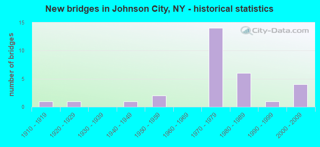
- New bridges - historical statistics
- 11910-1919
- 11920-1929
- 11940-1949
- 21950-1959
- 141970-1979
- 61980-1989
- 11990-1999
- 42000-2009
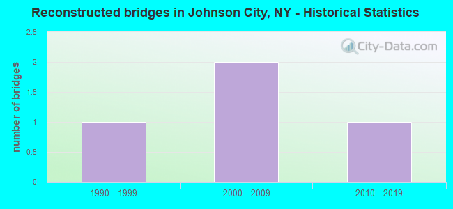
- Reconstructed bridges - Historical Statistics
- 11990-1999
- 22000-2009
- 12010-2019
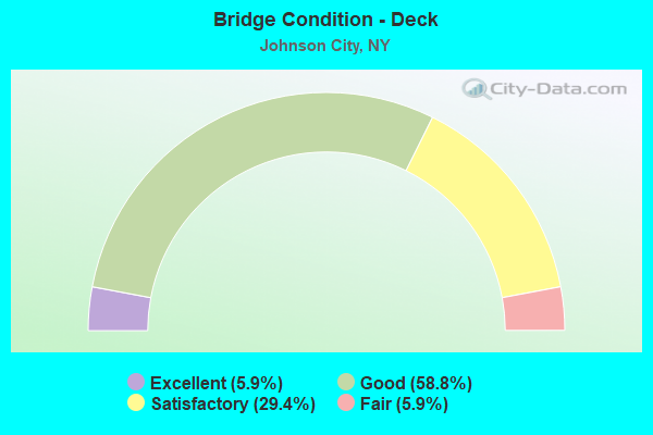
- Bridge Condition - Deck
- 5.9%Excellent
- 58.8%Good
- 29.4%Satisfactory
- 5.9%Fair
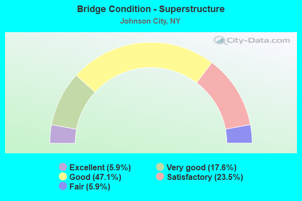
- Bridge Condition - Superstructure
- 5.9%Excellent
- 17.6%Very good
- 47.1%Good
- 23.5%Satisfactory
- 5.9%Fair
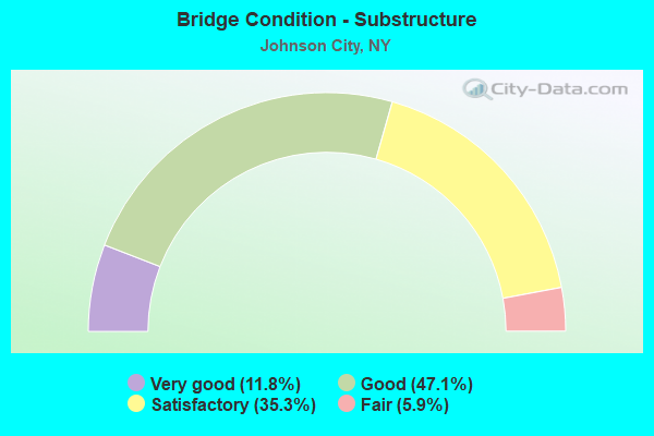
- Bridge Condition - Substructure
- 11.8%Very good
- 47.1%Good
- 35.3%Satisfactory
- 5.9%Fair
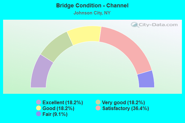
- Bridge Condition - Channel
- 18.2%Excellent
- 18.2%Very good
- 18.2%Good
- 36.4%Satisfactory
- 9.1%Fair
Find on map >> Show street view
Structure Number: 101432, Location: 1.1 MI E JCT SH17C &SH201 (Lat: 42.112439, Lng: -75.948256), Route carried "on" structure: State highway 17C, Year Built: 1980, Status: Open, Structure Length: 2.96m (9.71ft), Average Daily Traffic: 9,644 (year 2016), Truck Traffic: 3%, Average Future Daily Traffic: 11,715 (year 2040), Design Load: HS 20, Features Intersected: NORFOLK SOUTHERN RR
Minimum Vertical Clearance: 30+ m (98+ ft), Kilometerpoint: 15.060, Lanes on structure: 2, Base Highway Network: Yes, Owner: State Highway Agency, Approaching Roadway Width: 14.6m (47.9ft), Skew: 24 degrees, Material/Design: Prestressed concrete, Design/Construction: Box Beam or Girders - Multiple, Number Of Spans In Main Unit: 1, Length of Maximum Span: 27.4m (89.9ft), Curb or Sidewalk Widths: Left: 1.8m (5.9ft), Right: 1.8m (5.9ft), Curb-To-Curb Width: 14.6m (47.9ft), Out-to-Out Width: 19.0m (62.3ft)
Condition: Deck: Satisfactory, Superstructure: Good, Substructure: Satisfactory, Operating Rating: 98.9 metric tons, Method Used To Determine Operating Rating: Load Factor (LF), Inventory Rating: 57.2 metric tons, Method Used To Determine Inventory Rating: Load Factor (LF), Structural Evaluation: Equal to present minimum criteria, Deck Geometry: Superior to present desirable criteria, Underclear: Meets minimum limits, Approach Roadway Alignment: Equal to present desirable criteria, Length Of Structure Improvement: 2.95m (9.68ft), Designated Inspection Frequency: Every 24 months, Inspection Date: October 2020, Bridge Improvement Cost: $2,777,000, Roadway Improvement Cost: $1,626,000, Total Project Cost: $4,403,000 ( Estimate for 2021), Deck Structure Type: Concrete Cast-file-Place, Wearing Surface/Protective System: Wearing Surface: Integral Concrete
Find on map >> Show street view
Structure Number: 1063179, Location: 0.5 MI E JCT RTS 17 + 17C (Lat: 42.120158, Lng: -75.977194), Route carried "on" structure: State highway 17, Year Built: 1971, Status: Open, Structure Length: 3.17m (10.40ft), Average Daily Traffic: 46,428 (year 2014), Truck Traffic: 10%, Average Future Daily Traffic: 53,800 (year 2040), Design Load: HS 20+Mod, Features Intersected: OAKDALE ROAD
Minimum Vertical Clearance: 30+ m (98+ ft), Kilometerpoint: 12.518, Lanes on structure: 7, Lanes under structure: 2, Base Highway Network: Yes, Owner: State Highway Agency, Approaching Roadway Width: 36.3m (119.1ft), Skew: 20 degrees, Material/Design: Steel, Design/Construction: Stringer/Multi-beam, Number Of Spans In Main Unit: 1, Length of Maximum Span: 30.4m (99.7ft), Curb-To-Curb Width: 35.3m (115.8ft), Out-to-Out Width: 37.2m (122.0ft)
Condition: Deck: Satisfactory, Superstructure: Satisfactory, Substructure: Satisfactory, Operating Rating: 80.7 metric tons, Method Used To Determine Operating Rating: Load Factor (LF), Inventory Rating: 48.1 metric tons, Method Used To Determine Inventory Rating: Load Factor (LF), Structural Evaluation: Equal to present minimum criteria, Deck Geometry: Superior to present desirable criteria, Underclear: Better than present minimum criteria, Approach Roadway Alignment: Equal to present desirable criteria, Length Of Structure Improvement: 3.16m (10.37ft), Designated Inspection Frequency: Every 24 months, Inspection Date: May 2021, Bridge Improvement Cost: $3,863,000, Roadway Improvement Cost: $2,262,000, Total Project Cost: $6,125,000 ( Estimate for 2021), Deck Structure Type: Concrete Cast-file-Place, Wearing Surface/Protective System: Wearing Surface: Latex Concrete
Find on map >> Show street view
Structure Number: 1063189, Location: JCT RTS 201 + 17 (Lat: 42.119922, Lng: -75.969156), Route carried "on" structure: State highway 201, Year Built: 1971, Status: Open, Structure Length: 6.61m (21.69ft), Average Daily Traffic: 39,491 (year 2007), Truck Traffic: 10%, Average Future Daily Traffic: 45,762 (year 2040), Design Load: HS 20, Features Intersected: 17 17 91071082EB, RTE 1
Minimum Vertical Clearance: 30+ m (98+ ft), Kilometerpoint: 3.154, Lanes on structure: 6, Lanes under structure: 8, Base Highway Network: Yes, Owner: State Highway Agency, Approaching Roadway Width: 29.3m (96.1ft), Skew: 23 degrees, Material/Design: Steel, Design/Construction: Stringer/Multi-beam, Number Of Spans In Main Unit: 2, Length of Maximum Span: 32.6m (107.0ft), Curb-To-Curb Width: 28.3m (92.8ft), Out-to-Out Width: 30.1m (98.8ft)
Condition: Deck: Satisfactory, Superstructure: Good, Substructure: Good, Operating Rating: 78.0 metric tons, Method Used To Determine Operating Rating: Load Factor (LF), Inventory Rating: 46.3 metric tons, Method Used To Determine Inventory Rating: Load Factor (LF), Structural Evaluation: Better than present minimum criteria, Deck Geometry: Better than present minimum criteria, Underclear: High priority of corrective action, Approach Roadway Alignment: Equal to present desirable criteria, Length Of Structure Improvement: 6.61m (21.69ft), Designated Inspection Frequency: Every 24 months, Inspection Date: December 2021, Bridge Improvement Cost: $5,155,000, Roadway Improvement Cost: $3,019,000, Total Project Cost: $8,174,000 ( Estimate for 2021), Deck Structure Type: Concrete Cast-file-Place, Wearing Surface/Protective System: Wearing Surface: Monolithic Concrete
Find on map >> Show street view
Structure Number: 106319, Location: .2 MI E JCT SH 17 & SH 20 (Lat: 42.119717, Lng: -75.965389), Route carried "on" structure: Ramp State highway 17, Year Built: 1971, Status: Open, Structure Length: 0.82m (2.69ft), Average Daily Traffic: 52,780 (year 2014), Truck Traffic: 10%, Average Future Daily Traffic: 61,161 (year 2040), Design Load: HS 20+Mod, Features Intersected: FINCH HOLLOW CRK
Minimum Vertical Clearance: 30+ m (98+ ft), Kilometerpoint: 13.500, Lanes on structure: 8, Base Highway Network: Yes, Owner: State Highway Agency, Approaching Roadway Width: 46.6m (152.9ft), Skew: 22 degrees, Material/Design: Concrete, Design/Construction: Culvert, Number Of Spans In Main Unit: 1, Length of Maximum Span: 7.6m (24.9ft)
Condition: Channel: Satisfactory, Culverts: Satisfactory, Operating Rating: 89.8 metric tons, Method Used To Determine Operating Rating: Load Factor (LF), Inventory Rating: 53.5 metric tons, Method Used To Determine Inventory Rating: Load Factor (LF), Structural Evaluation: Equal to present minimum criteria, Waterway Adequacy: Superior to present desirable criteria, Approach Roadway Alignment: Equal to present desirable criteria, Length Of Structure Improvement: 0.82m (2.69ft), Designated Inspection Frequency: Every 24 months, Inspection Date: June 2020, Bridge Improvement Cost: $1,568,000, Roadway Improvement Cost: $918,000, Total Project Cost: $2,486,000 ( Estimate for 2021)
Find on map >> Show street view
Structure Number: 1063209, Location: 0.7 MI E JCT RTS 17 + 201 (Lat: 42.119333, Lng: -75.956456), Route carried "on" structure: State highway 17, Year Built: 1971, Status: Open, Structure Length: 3.23m (10.60ft), Average Daily Traffic: 52,780 (year 2014), Truck Traffic: 10%, Average Future Daily Traffic: 61,161 (year 2040), Design Load: HS 20+Mod, Features Intersected: NORTH BROAD ST
Minimum Vertical Clearance: 30+ m (98+ ft), Kilometerpoint: 14.240, Lanes on structure: 6, Lanes under structure: 2, Base Highway Network: Yes, Owner: State Highway Agency, Approaching Roadway Width: 32.6m (107.0ft), Skew: 20 degrees, Material/Design: Steel, Design/Construction: Stringer/Multi-beam, Number Of Spans In Main Unit: 1, Length of Maximum Span: 32.0m (105.0ft), Curb-To-Curb Width: 31.8m (104.3ft), Out-to-Out Width: 33.7m (110.6ft)
Condition: Deck: Satisfactory, Superstructure: Satisfactory, Substructure: Satisfactory, Operating Rating: 37.9 metric tons, Method Used To Determine Operating Rating: Load and Resistance Factor Rating (LRFR) rating reported by rating factor(RF) method using HL-93 loadings, Inventory Rating: 29.2 metric tons, Method Used To Determine Inventory Rating: Load and Resistance Factor Rating (LRFR) rating reported by rating factor(RF) method using HL-93 loadings, Structural Evaluation: Equal to present minimum criteria, Deck Geometry: Superior to present desirable criteria, Underclear: Equal to present minimum criteria, Approach Roadway Alignment: Equal to present desirable criteria, Length Of Structure Improvement: 3.23m (10.60ft), Designated Inspection Frequency: Every 24 months, Inspection Date: March 2021, Bridge Improvement Cost: $3,371,000, Roadway Improvement Cost: $1,974,000, Total Project Cost: $5,345,000 ( Estimate for 2021), Deck Structure Type: Concrete Cast-file-Place, Wearing Surface/Protective System: Wearing Surface: Latex Concrete
Find on map >> Show street view
Structure Number: 1063219, Location: 1.0 MI E JCT RTS 17 + 201 (Lat: 42.119792, Lng: -75.950458), Route carried "on" structure: State highway 17, Year Built: 1971, Status: Open, Structure Length: 8.02m (26.31ft), Average Daily Traffic: 52,780 (year 2014), Truck Traffic: 10%, Average Future Daily Traffic: 61,161 (year 2040), Design Load: HS 20+Mod, Features Intersected: LESTER AVENUE, LITTLE CH
Minimum Vertical Clearance: 30+ m (98+ ft), Kilometerpoint: 14.722, Lanes on structure: 8, Lanes under structure: 2, Base Highway Network: Yes, Owner: State Highway Agency, Approaching Roadway Width: 39.6m (129.9ft), Skew: 21 degrees, Material/Design: Steel, Design/Construction: Stringer/Multi-beam, Number Of Spans In Main Unit: 3, Length of Maximum Span: 29.3m (96.1ft), Curb-To-Curb Width: 35.7m (117.1ft), Out-to-Out Width: 37.5m (123.0ft)
Condition: Deck: Satisfactory, Superstructure: Satisfactory, Substructure: Good, Channel: Satisfactory, Operating Rating: 80.7 metric tons, Method Used To Determine Operating Rating: Load Factor (LF), Inventory Rating: 48.1 metric tons, Method Used To Determine Inventory Rating: Load Factor (LF), Structural Evaluation: Equal to present minimum criteria, Deck Geometry: Better than present minimum criteria, Underclear: Somewhat better than minimum adequacy, Waterway Adequacy: Meets minimum limits, Approach Roadway Alignment: Equal to present desirable criteria, Length Of Structure Improvement: 8.01m (26.28ft), Designated Inspection Frequency: Every 24 months, Inspection Date: July 2021, Bridge Improvement Cost: $7,037,000, Roadway Improvement Cost: $4,121,000, Total Project Cost: $11,158,000 ( Estimate for 2021), Deck Structure Type: Concrete Cast-file-Place, Wearing Surface/Protective System: Wearing Surface: Bituminous, Membrane: Other
Find on map >> Show street view
Structure Number: 1063289, Location: JCT RTS 201 & 17C (Lat: 42.115567, Lng: -75.968264), Route carried "on" structure: State highway 201, Year Built: 1971, Status: Open, Structure Length: 29.81m (97.80ft), Average Daily Traffic: 39,491 (year 2010), Truck Traffic: 10%, Average Future Daily Traffic: 45,762 (year 2040), Design Load: HS 20, Features Intersected: CROCKER PLACE, ENDWELL S
Minimum Vertical Clearance: 5.36m (17.59ft), Kilometerpoint: 2.719, Lanes on structure: 6, Lanes under structure: 10, Base Highway Network: Yes, Owner: State Highway Agency, Approaching Roadway Width: 31.4m (103.0ft), Skew: 30 degrees, Material/Design: Steel, Design/Construction: Stringer/Multi-beam, Number Of Spans In Main Unit: 8, Length of Maximum Span: 40.2m (131.9ft), Curb-To-Curb Width: 28.3m (92.8ft), Out-to-Out Width: 30.2m (99.1ft)
Condition: Deck: Good, Superstructure: Good, Substructure: Satisfactory, Channel: Excellent, Operating Rating: 54.4 metric tons, Method Used To Determine Operating Rating: Load Factor (LF), Inventory Rating: 32.7 metric tons, Method Used To Determine Inventory Rating: Load Factor (LF), Structural Evaluation: Equal to present minimum criteria, Deck Geometry: Somewhat better than minimum adequacy, Underclear: High priority of corrective action, Waterway Adequacy: Equal to present desirable criteria, Approach Roadway Alignment: Equal to present desirable criteria, Length Of Structure Improvement: 29.80m (97.77ft), Designated Inspection Frequency: Every 24 months, Inspection Date: October 2020, Bridge Improvement Cost: $18,996,000, Roadway Improvement Cost: $11,124,000, Total Project Cost: $30,120,000 ( Estimate for 2021), Deck Structure Type: Concrete Cast-file-Place, Wearing Surface/Protective System: Wearing Surface: Integral Concrete
Find on map >> Show street view
Structure Number: 106328A, Location: JCT SH 201 & SH 17C (Lat: 42.117475, Lng: -75.967956), Route carried "on" structure: Ramp State highway 201, Year Built: 1971, Status: Open, Structure Length: 7.62m (25.00ft), Average Daily Traffic: 8,079 (year 2017), Truck Traffic: 8%, Average Future Daily Traffic: 9,361 (year 2040), Design Load: HS 20+Mod, Features Intersected: NORFOLK SOUTHERN RR, LIT
Minimum Vertical Clearance: 30+ m (98+ ft), Kilometerpoint: 0.113, Lanes on structure: 1, Owner: State Highway Agency, Approaching Roadway Width: 9.8m (32.2ft), Skew: 1 degrees, Material/Design: Steel, Design/Construction: Stringer/Multi-beam, Number Of Spans In Main Unit: 2, Length of Maximum Span: 38.1m (125.0ft), Curb-To-Curb Width: 6.7m (22.0ft), Out-to-Out Width: 7.6m (24.9ft)
Condition: Deck: Good, Superstructure: Good, Substructure: Satisfactory, Channel: Excellent, Operating Rating: 84.4 metric tons, Method Used To Determine Operating Rating: Load Factor (LF), Inventory Rating: 49.9 metric tons, Method Used To Determine Inventory Rating: Load Factor (LF), Structural Evaluation: Equal to present minimum criteria, Deck Geometry: Equal to present minimum criteria, Underclear: Equal to present desirable criteria, Waterway Adequacy: Equal to present desirable criteria, Approach Roadway Alignment: Equal to present desirable criteria, Length Of Structure Improvement: 7.62m (25.00ft), Designated Inspection Frequency: Every 24 months, Inspection Date: October 2020, Bridge Improvement Cost: $1,334,000, Roadway Improvement Cost: $781,000, Total Project Cost: $2,116,000 ( Estimate for 2021), Deck Structure Type: Concrete Cast-file-Place, Wearing Surface/Protective System: Wearing Surface: Monolithic Concrete
Find on map >> Show street view
Structure Number: 1063309, Location: .2 MI N JCT SH 201 & SH 1 (Lat: 42.123322, Lng: -75.971281), Route carried "on" structure: State highway 201, Year Built: 1971, Status: Open, Structure Length: 1.65m (5.41ft), Average Daily Traffic: 28,995 (year 2014), Truck Traffic: 2%, Average Future Daily Traffic: 35,223 (year 2040), Design Load: H 20, Features Intersected: FINCH HOLLOW CRK
Minimum Vertical Clearance: 30+ m (98+ ft), Kilometerpoint: 0.370, Lanes on structure: 7, Base Highway Network: Yes, Owner: State Highway Agency, Approaching Roadway Width: 28.3m (92.8ft), Skew: 36 degrees, Material/Design: Concrete, Design/Construction: Culvert, Number Of Spans In Main Unit: 1, Length of Maximum Span: 8.2m (26.9ft)
Condition: Channel: Satisfactory, Culverts: Satisfactory, Structural Evaluation: Equal to present minimum criteria, Waterway Adequacy: Somewhat better than minimum adequacy, Approach Roadway Alignment: Equal to present desirable criteria, Length Of Structure Improvement: 1.64m (5.38ft), Designated Inspection Frequency: Every 24 months, Inspection Date: June 2020, Bridge Improvement Cost: $2,290,000, Roadway Improvement Cost: $1,341,000, Total Project Cost: $3,631,000 ( Estimate for 2021)
Find on map >> Show street view
Structure Number: 107297, Location: 0.2MI.S.JCT.RTES. 17 &201 (Lat: 42.109847, Lng: -75.966994), Route carried "on" structure: State highway 201, Year Built: 1986, Year Reconstructed: 2008, Status: Open, Structure Length: 22.65m (74.31ft), Average Daily Traffic: 39,303 (year 2010), Truck Traffic: 10%, Average Future Daily Traffic: 45,544 (year 2040), Design Load: HS 20, Features Intersected: GRAND AVENUE, CONRAIL
Minimum Vertical Clearance: 30+ m (98+ ft), Kilometerpoint: 2.027, Lanes on structure: 4, Lanes under structure: 2, Base Highway Network: Yes, Owner: State Highway Agency, Approaching Roadway Width: 24.4m (80.1ft), Skew: 22 degrees, Material/Design: Steel continuous, Design/Construction: Stringer/Multi-beam, Number Of Spans In Main Unit: 7, Length of Maximum Span: 36.5m (119.8ft), Curb-To-Curb Width: 21.3m (69.9ft), Out-to-Out Width: 22.3m (73.2ft)
Condition: Deck: Good, Superstructure: Good, Substructure: Satisfactory, Operating Rating: 79.8 metric tons, Method Used To Determine Operating Rating: Load Factor (LF), Inventory Rating: 43.5 metric tons, Method Used To Determine Inventory Rating: Load Factor (LF), Structural Evaluation: Equal to present minimum criteria, Deck Geometry: Better than present minimum criteria, Underclear: Superior to present desirable criteria, Approach Roadway Alignment: Equal to present desirable criteria, Length Of Structure Improvement: 22.64m (74.28ft), Designated Inspection Frequency: Every 24 months, Inspection Date: June 2020, Bridge Improvement Cost: $10,710,000, Roadway Improvement Cost: $6,272,000, Total Project Cost: $16,982,000 ( Estimate for 2021), Deck Structure Type: Concrete Cast-file-Place, Wearing Surface/Protective System: Wearing Surface: Integral Concrete, Deck Protection: Epoxy Coated Reinforcing
Find on map >> Show street view
Structure Number: 107848, Location: Jcy Rte 201 & Ramp A (Lat: 42.107889, Lng: -75.966561), Route carried "on" structure: State highway 201, Year Built: 2005, Status: Open, Structure Length: 3.69m (12.11ft), Average Daily Traffic: 29,987 (year 2020), Truck Traffic: 4%, Average Future Daily Traffic: 34,748 (year 2040), Design Load: HS 25 or greater, Features Intersected: Ramp A
Minimum Vertical Clearance: 30+ m (98+ ft), Kilometerpoint: 1.786, Lanes on structure: 4, Lanes under structure: 2, Base Highway Network: Yes, Owner: State Highway Agency, Approaching Roadway Width: 20.4m (66.9ft), Skew: 25 degrees, Material/Design: Steel, Design/Construction: Stringer/Multi-beam, Number Of Spans In Main Unit: 1, Length of Maximum Span: 33.9m (111.2ft), Curb-To-Curb Width: 20.4m (66.9ft), Out-to-Out Width: 22.0m (72.2ft)
Condition: Deck: Good, Superstructure: Very good, Substructure: Good, Operating Rating: 96.7 metric tons, Method Used To Determine Operating Rating: Field evaluation and documented engineering judgment, Inventory Rating: 40.8 metric tons, Method Used To Determine Inventory Rating: Field evaluation and documented engineering judgment, Structural Evaluation: Better than present minimum criteria, Deck Geometry: Equal to present minimum criteria, Underclear: High priority of corrective action, Approach Roadway Alignment: Equal to present desirable criteria, Length Of Structure Improvement: 3.68m (12.07ft), Designated Inspection Frequency: Every 24 months, Inspection Date: June 2021, Bridge Improvement Cost: $2,636,000, Roadway Improvement Cost: $1,544,000, Total Project Cost: $4,180,000 ( Estimate for 2021), Deck Structure Type: Concrete Cast-file-Place, Wearing Surface/Protective System: Wearing Surface: Integral Concrete, Deck Protection: Epoxy Coated Reinforcing
Find on map >> Show street view
Structure Number: 107849, Location: Jct Rte 201 & Ramp B (Lat: 42.106708, Lng: -75.967317), Route carried "on" structure: State highway 201, Year Built: 2005, Status: Open, Structure Length: 3.44m (11.29ft), Average Daily Traffic: 29,987 (year 2020), Truck Traffic: 4%, Average Future Daily Traffic: 34,748 (year 2040), Design Load: HS 25 or greater, Features Intersected: Ramp B
Minimum Vertical Clearance: 30+ m (98+ ft), Kilometerpoint: 1.641, Lanes on structure: 4, Lanes under structure: 1, Base Highway Network: Yes, Owner: State Highway Agency, Approaching Roadway Width: 21.1m (69.2ft), Skew: 25 degrees, Material/Design: Steel, Design/Construction: Stringer/Multi-beam, Number Of Spans In Main Unit: 1, Length of Maximum Span: 32.6m (107.0ft), Curb-To-Curb Width: 20.4m (66.9ft), Out-to-Out Width: 22.0m (72.2ft)
Condition: Deck: Good, Superstructure: Very good, Substructure: Very good, Operating Rating: 58.3 metric tons, Method Used To Determine Operating Rating: Load and Resistance Factor Rating (LRFR) rating reported by rating factor(RF) method using HL-93 loadings, Inventory Rating: 45.0 metric tons, Method Used To Determine Inventory Rating: Load and Resistance Factor Rating (LRFR) rating reported by rating factor(RF) method using HL-93 loadings, Structural Evaluation: Equal to present desirable criteria, Deck Geometry: Equal to present minimum criteria, Underclear: Somewhat better than minimum adequacy, Approach Roadway Alignment: Equal to present desirable criteria, Length Of Structure Improvement: 3.44m (11.29ft), Designated Inspection Frequency: Every 24 months, Inspection Date: June 2021, Bridge Improvement Cost: $2,193,000, Roadway Improvement Cost: $1,284,000, Total Project Cost: $3,477,000 ( Estimate for 2021), Deck Structure Type: Concrete Cast-file-Place, Wearing Surface/Protective System: Wearing Surface: Integral Concrete, Deck Protection: Epoxy Coated Reinforcing
Find on map >> Show street view
Structure Number: 22257, Location: VILLAGE OF JOHNSON CITY (Lat: 42.121086, Lng: -75.949014), Route carried "on" structure: Other road , Year Built: 1957, Status: Open, Structure Length: 1.62m (5.31ft), Average Daily Traffic: 210 (year 2018), Truck Traffic: 7%, Average Future Daily Traffic: 294 (year 2038), Design Load: HS 20, Features Intersected: LITTLE CHOCONUT CK, Facility Carried by Structure: OLD HARRY L DRIVE
Minimum Vertical Clearance: 30+ m (98+ ft), Kilometerpoint: 0.048, Lanes on structure: 2, Owner: Town or Township Highway Agency, Approaching Roadway Width: 9.8m (32.2ft), Material/Design: Steel, Design/Construction: Stringer/Multi-beam, Number Of Spans In Main Unit: 1, Length of Maximum Span: 15.5m (50.9ft), Curb or Sidewalk Widths: Left: 1.5m (4.9ft), Right: 1.5m (4.9ft), Curb-To-Curb Width: 9.7m (31.8ft), Out-to-Out Width: 13.4m (44.0ft)
Condition: Deck: Good, Superstructure: Fair, Substructure: Fair, Channel: Good, Operating Rating: 81.6 metric tons, Method Used To Determine Operating Rating: Load Factor (LF), Inventory Rating: 49.0 metric tons, Method Used To Determine Inventory Rating: Load Factor (LF), Structural Evaluation: Somewhat better than minimum adequacy, Deck Geometry: Equal to present minimum criteria, Waterway Adequacy: Equal to present desirable criteria, Approach Roadway Alignment: Equal to present desirable criteria, Length Of Structure Improvement: 1.61m (5.28ft), Designated Inspection Frequency: Every 24 months, Inspection Date: March 2020, Bridge Improvement Cost: $686,000, Roadway Improvement Cost: $401,000, Total Project Cost: $1,087,000 ( Estimate for 2021), Deck Structure Type: Concrete Cast-file-Place, Wearing Surface/Protective System: Wearing Surface: Integral Concrete, Deck Protection: Epoxy Coated Reinforcing
Find on map >> Show street view
Structure Number: 222571, Location: VILLAGE OF JOHNSON CITY (Lat: 42.124603, Lng: -75.975561), Route carried "on" structure: Other road , Year Built: 1941, Year Reconstructed: 1990, Status: Open, Structure Length: 1.25m (4.10ft), Average Daily Traffic: 7,870 (year 2009), Truck Traffic: 6%, Average Future Daily Traffic: 9,560 (year 2040), Design Load: HS 20, Features Intersected: FINCH HOLLOW CRK, Facility Carried by Structure: HARRY L ROAD
Minimum Vertical Clearance: 30+ m (98+ ft), Kilometerpoint: 0.595, Lanes on structure: 6, Owner: Town or Township Highway Agency, Approaching Roadway Width: 22.6m (74.1ft), Skew: 5 degrees, Material/Design: Steel, Design/Construction: Stringer/Multi-beam, Number Of Spans In Main Unit: 1, Length of Maximum Span: 9.7m (31.8ft), Curb or Sidewalk Widths: Left: 2.7m (8.9ft), Right: 0.0m, Curb-To-Curb Width: 22.6m (74.1ft), Out-to-Out Width: 26.1m (85.6ft)
Condition: Deck: Good, Superstructure: Good, Substructure: Good, Channel: Very good, Operating Rating: 75.3 metric tons, Method Used To Determine Operating Rating: Load Factor (LF), Inventory Rating: 44.5 metric tons, Method Used To Determine Inventory Rating: Load Factor (LF), Structural Evaluation: Better than present minimum criteria, Deck Geometry: Meets minimum limits, Waterway Adequacy: Equal to present minimum criteria, Approach Roadway Alignment: Equal to present desirable criteria, Length Of Structure Improvement: 1.24m (4.07ft), Designated Inspection Frequency: Every 24 months, Inspection Date: May 2021, Bridge Improvement Cost: $1,656,000, Roadway Improvement Cost: $970,000, Total Project Cost: $2,625,000 ( Estimate for 2021), Deck Structure Type: Concrete Cast-file-Place, Wearing Surface/Protective System: Wearing Surface: Integral Concrete, Deck Protection: Epoxy Coated Reinforcing
Find on map >> Show street view
Structure Number: 222581, Location: VILLAGE OF JOHNSON CITY (Lat: 42.115703, Lng: -75.950258), Route carried "on" structure: Business Other road , Year Built: 1987, Status: Open, Structure Length: 6.64m (21.78ft), Average Daily Traffic: 7,613 (year 2017), Truck Traffic: 3%, Average Future Daily Traffic: 9,419 (year 2040), Design Load: HS 20, Features Intersected: NORFOLK SOUTHERN RR, Facility Carried by Structure: LESTER AVENUE
Minimum Vertical Clearance: 30+ m (98+ ft), Kilometerpoint: 0.257, Lanes on structure: 2, Owner: Town or Township Highway Agency, Approaching Roadway Width: 9.8m (32.2ft), Skew: 1 degrees, Material/Design: Prestressed concrete, Design/Construction: Box Beam or Girders - Multiple, Number Of Spans In Main Unit: 3, Length of Maximum Span: 23.7m (77.8ft), Curb or Sidewalk Widths: Left: 1.5m (4.9ft), Right: 1.5m (4.9ft), Curb-To-Curb Width: 9.8m (32.2ft), Out-to-Out Width: 13.3m (43.6ft)
Condition: Deck: Fair, Superstructure: Satisfactory, Substructure: Good, Operating Rating: 90.7 metric tons, Method Used To Determine Operating Rating: Load Factor (LF), Inventory Rating: 48.1 metric tons, Method Used To Determine Inventory Rating: Load Factor (LF), Structural Evaluation: Equal to present minimum criteria, Deck Geometry: Meets minimum limits, Underclear: Somewhat better than minimum adequacy, Approach Roadway Alignment: Equal to present desirable criteria, Length Of Structure Improvement: 6.64m (21.78ft), Designated Inspection Frequency: Every 24 months, Inspection Date: September 2020, Bridge Improvement Cost: $2,126,000, Roadway Improvement Cost: $1,245,000, Total Project Cost: $3,370,000 ( Estimate for 2021), Wearing Surface/Protective System: Wearing Surface: Integral Concrete
Find on map >> Show street view
Structure Number: 222583, Location: VILLAGE OF JOHNSON CITY (Lat: 42.117511, Lng: -75.957028), Route carried "on" structure: Alternate Other road , Year Built: 1983, Year Reconstructed: 2016, Status: Open, Structure Length: 12.59m (41.31ft), Average Daily Traffic: 3,653 (year 2017), Truck Traffic: 3%, Average Future Daily Traffic: 4,519 (year 2040), Design Load: HS 20, Features Intersected: OLIVE STREET, LITTLE CHO, Facility Carried by Structure: ARCH STREET
Minimum Vertical Clearance: 30+ m (98+ ft), Kilometerpoint: 0.531, Lanes on structure: 2, Lanes under structure: 2, Owner: Town or Township Highway Agency, Approaching Roadway Width: 9.1m (29.9ft), Material/Design: Steel, Design/Construction: Stringer/Multi-beam, Number Of Spans In Main Unit: 4, Length of Maximum Span: 38.7m (127.0ft), Curb or Sidewalk Widths: Left: 1.8m (5.9ft), Right: 1.8m (5.9ft), Curb-To-Curb Width: 9.1m (29.9ft), Out-to-Out Width: 13.4m (44.0ft)
Condition: Deck: Excellent, Superstructure: Very good, Substructure: Very good, Channel: Good, Operating Rating: 75.3 metric tons, Method Used To Determine Operating Rating: Load Factor (LF), Inventory Rating: 45.4 metric tons, Method Used To Determine Inventory Rating: Load Factor (LF), Structural Evaluation: Equal to present desirable criteria, Deck Geometry: Meets minimum limits, Underclear: Meets minimum limits, Waterway Adequacy: Equal to present minimum criteria, Approach Roadway Alignment: Equal to present minimum criteria, Length Of Structure Improvement: 12.58m (41.27ft), Designated Inspection Frequency: Every 24 months, Inspection Date: September 2020, Bridge Improvement Cost: $3,843,000, Roadway Improvement Cost: $2,250,000, Total Project Cost: $6,094,000 ( Estimate for 2021), Deck Structure Type: Concrete Cast-file-Place, Wearing Surface/Protective System: Wearing Surface: Integral Concrete, Deck Protection: Epoxy Coated Reinforcing
Find on map >> Show street view
Structure Number: 225765, Location: VILLAGE OF JOHNSON CITY (Lat: 42.121878, Lng: -75.948339), Route carried "on" structure: Other road , Year Built: 1972, Status: Open, Structure Length: 3.57m (11.71ft), Average Daily Traffic: 8,408 (year 2020), Truck Traffic: 4%, Average Future Daily Traffic: 10,214 (year 2040), Features Intersected: LITTLE CHOCONUT CREEK, Facility Carried by Structure: HARRY L.DRIVE
Minimum Vertical Clearance: 30+ m (98+ ft), Kilometerpoint: 2.977, Lanes on structure: 2, Owner: Town or Township Highway Agency, Approaching Roadway Width: 10.4m (34.1ft), Skew: 6 degrees, Material/Design: Steel, Design/Construction: Stringer/Multi-beam, Number Of Spans In Main Unit: 1, Length of Maximum Span: 35.1m (115.2ft), Curb or Sidewalk Widths: Left: 1.4m (4.6ft), Right: 1.4m (4.6ft), Curb-To-Curb Width: 13.4m (44.0ft), Out-to-Out Width: 17.2m (56.4ft)
Condition: Deck: Good, Superstructure: Good, Substructure: Good, Channel: Very good, Operating Rating: 89.8 metric tons, Method Used To Determine Operating Rating: Load Factor (LF), Inventory Rating: 53.5 metric tons, Method Used To Determine Inventory Rating: Load Factor (LF), Structural Evaluation: Better than present minimum criteria, Deck Geometry: Equal to present minimum criteria, Waterway Adequacy: Equal to present minimum criteria, Approach Roadway Alignment: Equal to present desirable criteria, Length Of Structure Improvement: 3.56m (11.68ft), Designated Inspection Frequency: Every 24 months, Inspection Date: July 2020, Bridge Improvement Cost: $2,700,000, Roadway Improvement Cost: $1,581,000, Total Project Cost: $4,282,000 ( Estimate for 2021), Deck Structure Type: Concrete Cast-file-Place, Wearing Surface/Protective System: Wearing Surface: Integral Concrete
Find on map >> Show street view
Structure Number: 226821, Location: VILLAGE OF JOHNSON CITY (Lat: 42.124303, Lng: -75.974856), Route carried "on" structure: Other road , Year Built: 1990, Status: Open, Structure Length: 1.01m (3.31ft), Average Daily Traffic: 13,701 (year 2013), Truck Traffic: 7%, Average Future Daily Traffic: 19,181 (year 2033), Design Load: HS 20, Features Intersected: FINCH HOLLOW CRK, Facility Carried by Structure: WEGMANS-ENTRANCE
Minimum Vertical Clearance: 30+ m (98+ ft), Kilometerpoint: 0.048, Lanes on structure: 5, Owner: Town or Township Highway Agency, Approaching Roadway Width: 19.8m (65.0ft), Skew: 21 degrees, Material/Design: Steel, Design/Construction: Stringer/Multi-beam, Number Of Spans In Main Unit: 1, Length of Maximum Span: 9.7m (31.8ft), Curb or Sidewalk Widths: Left: 2.7m (8.9ft), Right: 0.0m, Curb-To-Curb Width: 19.8m (65.0ft), Out-to-Out Width: 24.5m (80.4ft)
Condition: Deck: Good, Superstructure: Good, Substructure: Good, Channel: Satisfactory, Operating Rating: 83.5 metric tons, Method Used To Determine Operating Rating: Load Factor (LF), Inventory Rating: 49.9 metric tons, Method Used To Determine Inventory Rating: Load Factor (LF), Structural Evaluation: Better than present minimum criteria, Deck Geometry: Meets minimum limits, Waterway Adequacy: Somewhat better than minimum adequacy, Approach Roadway Alignment: Equal to present desirable criteria, Length Of Structure Improvement: 1.00m (3.28ft), Designated Inspection Frequency: Every 24 months, Inspection Date: September 2021, Bridge Improvement Cost: $1,338,000, Roadway Improvement Cost: $784,000, Total Project Cost: $2,122,000 ( Estimate for 2021), Deck Structure Type: Concrete Cast-file-Place, Wearing Surface/Protective System: Wearing Surface: Integral Concrete, Deck Protection: Epoxy Coated Reinforcing
Find on map >> Show street view
Structure Number: 334984, Location: VILLAGE OF JOHNSON CITY (Lat: 42.117897, Lng: -75.950561), Route carried "on" structure: Other road , Year Built: 1956, Year Reconstructed: 2005, Status: Open, Structure Length: 2.23m (7.32ft), Average Daily Traffic: 2,954 (year 2020), Truck Traffic: 2%, Average Future Daily Traffic: 3,654 (year 2040), Design Load: HS 25 or greater, Features Intersected: LITT CHOCONUT CRK, Facility Carried by Structure: LESTER AVENUE
Minimum Vertical Clearance: 30+ m (98+ ft), Kilometerpoint: 0.515, Lanes on structure: 3, Owner: County Highway Agency, Approaching Roadway Width: 10.1m (33.1ft), Skew: 3 degrees, Material/Design: Steel, Design/Construction: Stringer/Multi-beam, Number Of Spans In Main Unit: 1, Length of Maximum Span: 21.3m (69.9ft), Curb or Sidewalk Widths: Left: 1.5m (4.9ft), Right: 1.5m (4.9ft), Curb-To-Curb Width: 10.1m (33.1ft), Out-to-Out Width: 14.5m (47.6ft)
Condition: Deck: Good, Superstructure: Excellent, Substructure: Good, Channel: Fair, Operating Rating: 95.3 metric tons, Method Used To Determine Operating Rating: Load Factor (LF), Inventory Rating: 57.2 metric tons, Method Used To Determine Inventory Rating: Load Factor (LF), Structural Evaluation: Better than present minimum criteria, Deck Geometry: High priority of replacement, Waterway Adequacy: Meets minimum limits, Approach Roadway Alignment: Meets minimum limits, Length Of Structure Improvement: 2.22m (7.28ft), Designated Inspection Frequency: Every 24 months, Inspection Date: September 2021, Bridge Improvement Cost: $1,100,000, Roadway Improvement Cost: $644,000, Total Project Cost: $1,745,000 ( Estimate for 2021), Deck Structure Type: Concrete Cast-file-Place, Wearing Surface/Protective System: Wearing Surface: Integral Concrete
Find on map >> Show street view
Structure Number: 1063179, Location: 0.5 MI E JCT RTS 17 + 17C (Lat: 42.120158, Lng: -75.977194), Route carried "under" structure: Business Other road , Year Built: 1971, Structure Length: 0. m, Average Daily Traffic: 4,647 (year 2018), Truck Traffic: 5%, Features Intersected: OAKDALE ROAD, Facility Carried by Structure: RTE 17
Minimum Vertical Clearance: 4.90m (16.08ft), Kilometerpoint: 0.000, Lanes on structure: 7, Lanes under structure: 2, Material/Design: Steel, Design/Construction: Stringer/Multi-beam, Length of Maximum Span: 30.4m (99.7ft)
Find on map >> Show street view
Structure Number: 1063189, Location: JCT RTS 201 + 17 (Lat: 42.119922, Lng: -75.969156), Route carried "under" structure: State highway 17, Year Built: 1971, Structure Length: 0. m, Average Daily Traffic: 46,927 (year 1999), Features Intersected: 17 17 91071082EB, RTE 1, Facility Carried by Structure: RTE 201
Minimum Vertical Clearance: 5.08m (16.67ft), Kilometerpoint: 13.178, Lanes on structure: 6, Lanes under structure: 4, Material/Design: Steel, Design/Construction: Stringer/Multi-beam, Length of Maximum Span: 32.6m (107.0ft)
Find on map >> Show street view
Structure Number: 1063209, Location: 0.7 MI E JCT RTS 17 + 201 (Lat: 42.119333, Lng: -75.956456), Route carried "under" structure: Bypass Other road , Year Built: 1971, Structure Length: 0. m, Average Daily Traffic: 2,792 (year 2019), Truck Traffic: 5%, Features Intersected: NORTH BROAD ST, Facility Carried by Structure: RTE 17
Minimum Vertical Clearance: 4.69m (15.39ft), Kilometerpoint: 0.225, Lanes on structure: 6, Lanes under structure: 2, Material/Design: Steel, Design/Construction: Stringer/Multi-beam, Length of Maximum Span: 32.0m (105.0ft)
Find on map >> Show street view
Structure Number: 1063219, Location: 1.0 MI E JCT RTS 17 + 201 (Lat: 42.119792, Lng: -75.950458), Route carried "under" structure: Bypass Other road , Year Built: 1971, Structure Length: 0. m, Average Daily Traffic: 2,954 (year 2020), Truck Traffic: 2%, Features Intersected: LESTER AVENUE, LITTLE CH, Facility Carried by Structure: RTE 17
Minimum Vertical Clearance: 4.65m (15.26ft), Kilometerpoint: 0.628, Lanes on structure: 8, Lanes under structure: 2, Material/Design: Steel, Design/Construction: Stringer/Multi-beam, Length of Maximum Span: 29.3m (96.1ft)
Find on map >> Show street view
Structure Number: 1063289, Location: JCT RTS 201 & 17C (Lat: 42.115567, Lng: -75.968264), Route carried "under" structure: State highway 17C, Year Built: 1971, Structure Length: 0. m, Average Daily Traffic: 4,842 (year 1999), Features Intersected: CROCKER PLACE, ENDWELL S, Facility Carried by Structure: RTE 201
Minimum Vertical Clearance: 5.63m (18.47ft), Kilometerpoint: 0.772, Lanes on structure: 6, Lanes under structure: 6, Material/Design: Steel, Design/Construction: Stringer/Multi-beam, Length of Maximum Span: 40.2m (131.9ft)
Find on map >> Show street view
Structure Number: 107297, Location: 0.2MI.S.JCT.RTES. 17 &201 (Lat: 42.109847, Lng: -75.966994), Route carried "under" structure: Business City street , Year Built: 1986, Structure Length: 0. m, Average Daily Traffic: 1,785 (year 2014), Truck Traffic: 5%, Features Intersected: GRAND AVENUE, CONRAIL, Facility Carried by Structure: RTE 201
Minimum Vertical Clearance: 8.99m (29.49ft), Kilometerpoint: 0.290, Lanes on structure: 4, Lanes under structure: 2, Material/Design: Steel continuous, Design/Construction: Stringer/Multi-beam, Length of Maximum Span: 36.5m (119.8ft)
Find on map >> Show street view
Structure Number: 107848, Location: Jcy Rte 201 & Ramp A (Lat: 42.107889, Lng: -75.966561), Route carried "under" structure: Other road , Year Built: 2005, Structure Length: 0. m, Average Daily Traffic: 7,000 (year 2004), Features Intersected: Ramp A, Facility Carried by Structure: RTE 201
Minimum Vertical Clearance: 4.65m (15.26ft), Kilometerpoint: 0.000, Lanes on structure: 4, Lanes under structure: 2, Material/Design: Steel, Design/Construction: Stringer/Multi-beam, Length of Maximum Span: 33.9m (111.2ft)
Find on map >> Show street view
Structure Number: 107849, Location: Jct Rte 201 & Ramp B (Lat: 42.106708, Lng: -75.967317), Route carried "under" structure: Ramp State highway , Year Built: 2005, Structure Length: 0. m, Features Intersected: Ramp B, Facility Carried by Structure: RTE 201
Minimum Vertical Clearance: 4.50m (14.76ft), Kilometerpoint: 0.000, Lanes on structure: 4, Lanes under structure: 1, Material/Design: Steel, Design/Construction: Stringer/Multi-beam, Length of Maximum Span: 32.6m (107.0ft)
Find on map >> Show street view
Structure Number: 222583, Location: VILLAGE OF JOHNSON CITY (Lat: 42.117511, Lng: -75.957028), Route carried "under" structure: Alternate Other road , Year Built: 1983, Structure Length: 0. m, Features Intersected: OLIVE STREET, LITTLE CHO, Facility Carried by Structure: ARCH STREET
Minimum Vertical Clearance: 5.64m (18.50ft), Kilometerpoint: 0.000, Lanes on structure: 2, Lanes under structure: 2, Material/Design: Steel, Design/Construction: Stringer/Multi-beam, Length of Maximum Span: 38.7m (127.0ft)
Find on map >> Show street view
Structure Number: 701436, Location: 1.2 MI.N.JCT.RTS.201+ 434 (Lat: 42.110817, Lng: -75.967875), Route carried "under" structure: State highway , Year Built: 1921, Structure Length: 0. m, Average Daily Traffic: 1,105 (year 2020), Truck Traffic: 4%, Features Intersected: RIVERSIDE DRIVE, Facility Carried by Structure: NORFOLK SOUTHERN
Minimum Vertical Clearance: 3.68m (12.07ft), Kilometerpoint: 0.000, Lanes under structure: 2, Material/Design: Concrete continuous, Design/Construction: Slab, Length of Maximum Span: 7.6m (24.9ft)
Find on map >> Show street view
Structure Number: 770223, Location: VILLAGE OF JOHNSON CITY (Lat: 42.118131, Lng: -75.977011), Route carried "under" structure: Other road , Year Built: 1910, Structure Length: 0. m, Average Daily Traffic: 1,000 (year 2021), Features Intersected: OAKDALE ROAD, Facility Carried by Structure: NORFOLK SOUTHERN
Minimum Vertical Clearance: 3.35m (10.99ft), Kilometerpoint: 0.000, Lanes under structure: 2, Material/Design: Steel, Design/Construction: Girder and Floorbeam System, Length of Maximum Span: 11.2m (36.7ft)