Bridge Statistics for Johnston, Rhode Island (RI)
Condition, Traffic, Stress, Structural Evaluation, Project Costs
- National Bridge Inventory (NBI) Statistics
- 30Number of bridges
- 213ft / 64.5mTotal length
- $27,092,000Total costs
- 884,723Total average daily traffic
- 93,946Total average daily truck traffic
- National Bridge Inventory (NBI) Registered Bridges for Johnston
- No street view available for this location
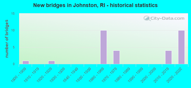
- New bridges - historical statistics
- 11900-1909
- 11920-1929
- 101960-1969
- 41970-1979
- 42010-2019
- 102020-2022
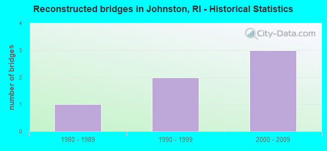
- Reconstructed bridges - Historical Statistics
- 11980-1989
- 21990-1999
- 32000-2009
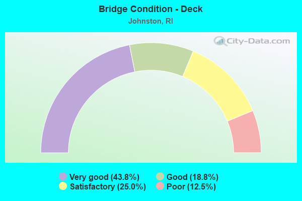
- Bridge Condition - Deck
- 43.8%Very good
- 18.8%Good
- 25.0%Satisfactory
- 12.5%Poor
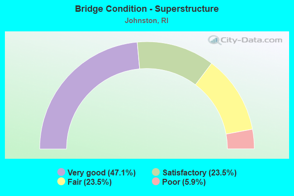
- Bridge Condition - Superstructure
- 47.1%Very good
- 23.5%Satisfactory
- 23.5%Fair
- 5.9%Poor
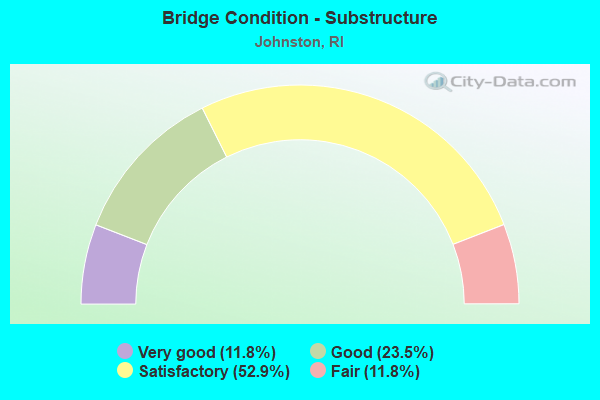
- Bridge Condition - Substructure
- 11.8%Very good
- 23.5%Good
- 52.9%Satisfactory
- 11.8%Fair
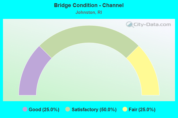
- Bridge Condition - Channel
- 25.0%Good
- 50.0%Satisfactory
- 25.0%Fair
Find on map >> Show street view
Structure Number: 146, Location: 0.1 Mi E of JCT RI 128 (Lat: 41.859097, Lng: -71.487389), Route carried "on" structure: US 44, Year Built: 1920, Year Reconstructed: 1987, Status: Open, Structure Length: 1.83m (6.00ft), Average Daily Traffic: 16,893 (year 2021), Truck Traffic: 5%, Average Future Daily Traffic: 18,582 (year 2041), Design Load: HS 20, Features Intersected: WOONASQUATUCKET RIVER
Minimum Vertical Clearance: 30+ m (98+ ft), Kilometerpoint: 28.485, Lanes on structure: 2, Base Highway Network: Yes, Owner: State Highway Agency, Approaching Roadway Width: 10.1m (33.1ft), Skew: 3 degrees, Material/Design: Concrete, Design/Construction: Arch - Deck, Number Of Spans In Main Unit: 1, Length of Maximum Span: 18.3m (60.0ft), Curb or Sidewalk Widths: Left: 2.1m (6.9ft), Right: 2.0m (6.6ft), Curb-To-Curb Width: 10.1m (33.1ft), Out-to-Out Width: 14.8m (48.6ft)
Condition: Superstructure: Fair, Substructure: Satisfactory, Channel: Fair, Operating Rating: 97.2 metric tons, Method Used To Determine Operating Rating: Load and Resistance Factor Rating (LRFR) rating reported by rating factor(RF) method using HL-93 loadings, Inventory Rating: 77.8 metric tons, Method Used To Determine Inventory Rating: Load and Resistance Factor Rating (LRFR) rating reported by rating factor(RF) method using HL-93 loadings, Structural Evaluation: Somewhat better than minimum adequacy, Deck Geometry: Meets minimum limits, Waterway Adequacy: Equal to present desirable criteria, Approach Roadway Alignment: Equal to present desirable criteria, Length Of Structure Improvement: 1.74m (5.71ft), Designated Inspection Frequency: Every 24 months, Inspection Date: July 2020, Bridge Improvement Cost: $529,000, Roadway Improvement Cost: $53,000, Total Project Cost: $793,000
Find on map >> Show street view
Structure Number: 3265, Location: 0.9 Mi S of JCT RI 5 (Lat: 41.797836, Lng: -71.505128), Route carried "on" structure: City street , Year Built: 2018, Status: Open, Structure Length: 1.44m (4.72ft), Average Daily Traffic: 5,588 (year 2021), Truck Traffic: 7%, Average Future Daily Traffic: 6,147 (year 2041), Design Load: HL 93, Features Intersected: SIMMONS BROOK, Facility Carried by Structure: SIMMONSVILLE AV
Minimum Vertical Clearance: 30+ m (98+ ft), Kilometerpoint: 1.025, Lanes on structure: 2, Owner: State Highway Agency, Approaching Roadway Width: 10.2m (33.5ft), Skew: 4 degrees, Material/Design: Prestressed concrete, Design/Construction: Box Beam or Girders - Multiple, Number Of Spans In Main Unit: 1, Length of Maximum Span: 13.7m (44.9ft), Curb or Sidewalk Widths: Left: 1.9m (6.2ft), Right: 1.9m (6.2ft), Curb-To-Curb Width: 10.2m (33.5ft), Out-to-Out Width: 14.6m (47.9ft)
Condition: Deck: Very good, Superstructure: Very good, Substructure: Very good, Channel: Good, Operating Rating: 97.2 metric tons, Method Used To Determine Operating Rating: Load and Resistance Factor Rating (LRFR) rating reported by rating factor(RF) method using HL-93 loadings, Inventory Rating: 64.5 metric tons, Method Used To Determine Inventory Rating: Load and Resistance Factor Rating (LRFR) rating reported by rating factor(RF) method using HL-93 loadings, Structural Evaluation: Equal to present desirable criteria, Deck Geometry: Meets minimum limits, Waterway Adequacy: Superior to present desirable criteria, Approach Roadway Alignment: Meets minimum limits, Length Of Structure Improvement: 0.85m (2.79ft), Designated Inspection Frequency: Every 24 months, Inspection Date: November 2020, Bridge Improvement Cost: $9,000, Roadway Improvement Cost: $1,000, Total Project Cost: $14,000, Deck Structure Type: Concrete Cast-file-Place, Wearing Surface/Protective System: Wearing Surface: Bituminous, Membrane: Other, Deck Protection: Epoxy Coated Reinforcing
Find on map >> Show street view
Structure Number: 608, Location: 1 Mi E JCT RI 5 (Lat: 41.820331, Lng: -71.478517), Route carried "on" structure: US 6A, Year Built: 1969, Status: Open, Structure Length: 5.58m (18.31ft), Average Daily Traffic: 7,504 (year 2021), Truck Traffic: 4%, Average Future Daily Traffic: 8,254 (year 2041), Design Load: HS 20, Features Intersected: US 6
Minimum Vertical Clearance: 30+ m (98+ ft), Kilometerpoint: 3.804, Lanes on structure: 2, Lanes under structure: 7, Owner: State Highway Agency, Approaching Roadway Width: 13.4m (44.0ft), Skew: 4 degrees, Material/Design: Steel, Design/Construction: Stringer/Multi-beam, Number Of Spans In Main Unit: 2, Length of Maximum Span: 28.3m (92.8ft), Curb or Sidewalk Widths: Left: 1.5m (4.9ft), Right: 1.5m (4.9ft), Curb-To-Curb Width: 13.4m (44.0ft), Out-to-Out Width: 17.1m (56.1ft)
Condition: Deck: Poor, Superstructure: Fair, Substructure: Fair, Operating Rating: 42.8 metric tons, Method Used To Determine Operating Rating: Load and Resistance Factor Rating (LRFR) rating reported by rating factor(RF) method using HL-93 loadings, Inventory Rating: 33.0 metric tons, Method Used To Determine Inventory Rating: Load and Resistance Factor Rating (LRFR) rating reported by rating factor(RF) method using HL-93 loadings, Structural Evaluation: Somewhat better than minimum adequacy, Deck Geometry: Equal to present minimum criteria, Underclear: High priority of corrective action, Approach Roadway Alignment: Better than present minimum criteria, Length Of Structure Improvement: 5.58m (18.31ft), Designated Inspection Frequency: Every 24 months, Other Special Inspection Frequency: Every 12 months, Inspection Date: September 2020, Other Special Inspection Date: September 2021, Bridge Improvement Cost: $6,617,000, Roadway Improvement Cost: $662,000, Total Project Cost: $9,926,000, Deck Structure Type: Concrete Cast-file-Place, Wearing Surface/Protective System: Wearing Surface: Bituminous, Membrane: Built-up
Find on map >> Show street view
Structure Number: 609, Location: 1.0 Mi E of JCT RI 5 (Lat: 41.819356, Lng: -71.480894), Route carried "on" structure: US 6, Year Built: 1969, Status: Posted for load, Structure Length: 3.99m (13.09ft), Average Daily Traffic: 53,619 (year 2015), Truck Traffic: 1%, Average Future Daily Traffic: 64,343 (year 2036), Design Load: HS 20, Features Intersected: US 6A HARTFORD AV RAMP
Minimum Vertical Clearance: 30+ m (98+ ft), Kilometerpoint: 28.551, Lanes on structure: 6, Lanes under structure: 1, Base Highway Network: Yes, Owner: State Highway Agency, Approaching Roadway Width: 34.1m (111.9ft), Skew: 34 degrees, Material/Design: Steel, Design/Construction: Stringer/Multi-beam, Number Of Spans In Main Unit: 2, Length of Maximum Span: 26.5m (86.9ft), Curb-To-Curb Width: 30.5m (100.1ft), Out-to-Out Width: 34.4m (112.9ft)
Condition: Deck: Poor, Superstructure: Poor, Substructure: Fair, Operating Rating: 16.2 metric tons, Method Used To Determine Operating Rating: Load and Resistance Factor Rating (LRFR) rating reported by rating factor(RF) method using HL-93 loadings, Inventory Rating: 12.3 metric tons, Method Used To Determine Inventory Rating: Load and Resistance Factor Rating (LRFR) rating reported by rating factor(RF) method using HL-93 loadings, Structural Evaluation: High priority of corrective action, Deck Geometry: Superior to present desirable criteria, Underclear: Equal to present minimum criteria, Approach Roadway Alignment: Better than present minimum criteria, Bridge Posting: Required (Relationship of Operating Rating to Maximum Legal Load: 30.0 - 39.9% below), Length Of Structure Improvement: 3.99m (13.09ft), Designated Inspection Frequency: Every 24 months, Other Special Inspection Frequency: Every 12 months, Inspection Date: July 2020, Other Special Inspection Date: July 2021, Bridge Improvement Cost: $1,671,000, Roadway Improvement Cost: $167,000, Total Project Cost: $2,507,000, Deck Structure Type: Concrete Cast-file-Place, Wearing Surface/Protective System: Wearing Surface: Bituminous, Membrane: Built-up
Find on map >> Show street view
Structure Number: 611, Location: 1.0 Mi S of JCT RI 5 (Lat: 41.816967, Lng: -71.496642), Route carried "on" structure: US 6, Year Built: 1971, Year Reconstructed: 2004, Status: Open, Structure Length: 3.54m (11.61ft), Average Daily Traffic: 300 (year 2021), Truck Traffic: 15%, Average Future Daily Traffic: 330 (year 2041), Design Load: HS 20, Features Intersected: RI 5 ATWOOD AV
Minimum Vertical Clearance: 30+ m (98+ ft), Kilometerpoint: 27.122, Lanes on structure: 3, Lanes under structure: 4, Base Highway Network: Yes, Owner: State Highway Agency, Approaching Roadway Width: 15.2m (49.9ft), Skew: 2 degrees, Material/Design: Steel, Design/Construction: Stringer/Multi-beam, Number Of Spans In Main Unit: 1, Length of Maximum Span: 34.4m (112.9ft), Curb-To-Curb Width: 15.2m (49.9ft), Out-to-Out Width: 17.1m (56.1ft)
Condition: Deck: Satisfactory, Superstructure: Fair, Substructure: Satisfactory, Operating Rating: 32.1 metric tons, Method Used To Determine Operating Rating: Load and Resistance Factor Rating (LRFR) rating reported by rating factor(RF) method using HL-93 loadings, Inventory Rating: 24.9 metric tons, Method Used To Determine Inventory Rating: Load and Resistance Factor Rating (LRFR) rating reported by rating factor(RF) method using HL-93 loadings, Structural Evaluation: Somewhat better than minimum adequacy, Deck Geometry: Meets minimum limits, Underclear: Equal to present minimum criteria, Approach Roadway Alignment: Equal to present desirable criteria, Length Of Structure Improvement: 3.54m (11.61ft), Designated Inspection Frequency: Every 24 months, Inspection Date: August 2020, Bridge Improvement Cost: $574,000, Roadway Improvement Cost: $57,000, Total Project Cost: $861,000, Deck Structure Type: Concrete Cast-file-Place, Wearing Surface/Protective System: Wearing Surface: Bituminous, Membrane: Built-up
Find on map >> Show street view
Structure Number: 6112, Location: 1.0 MI S JCT RI5 (Lat: 41.817197, Lng: -71.496714), Route carried "on" structure: US 6, Year Built: 1971, Year Reconstructed: 2004, Status: Open, Structure Length: 3.54m (11.61ft), Average Daily Traffic: 59,500 (year 2021), Truck Traffic: 11%, Average Future Daily Traffic: 65,450 (year 2041), Design Load: HS 20, Features Intersected: RI 5 ATWOOD AV
Minimum Vertical Clearance: 30+ m (98+ ft), Kilometerpoint: 8.467, Lanes on structure: 3, Lanes under structure: 4, Base Highway Network: Yes, Owner: State Highway Agency, Approaching Roadway Width: 15.2m (49.9ft), Skew: 2 degrees, Material/Design: Steel, Design/Construction: Stringer/Multi-beam, Number Of Spans In Main Unit: 1, Length of Maximum Span: 34.4m (112.9ft), Curb-To-Curb Width: 15.2m (49.9ft), Out-to-Out Width: 17.1m (56.1ft)
Condition: Deck: Satisfactory, Superstructure: Satisfactory, Substructure: Satisfactory, Operating Rating: 39.5 metric tons, Method Used To Determine Operating Rating: Load and Resistance Factor Rating (LRFR) rating reported by rating factor(RF) method using HL-93 loadings, Inventory Rating: 30.5 metric tons, Method Used To Determine Inventory Rating: Load and Resistance Factor Rating (LRFR) rating reported by rating factor(RF) method using HL-93 loadings, Structural Evaluation: Equal to present minimum criteria, Deck Geometry: Meets minimum limits, Underclear: Somewhat better than minimum adequacy, Approach Roadway Alignment: Equal to present desirable criteria, Length Of Structure Improvement: 3.54m (11.61ft), Designated Inspection Frequency: Every 24 months, Inspection Date: August 2020, Bridge Improvement Cost: $574,000, Roadway Improvement Cost: $57,000, Total Project Cost: $861,000, Deck Structure Type: Concrete Cast-file-Place, Wearing Surface/Protective System: Wearing Surface: Bituminous, Membrane: Built-up
Find on map >> Show street view
Structure Number: 734, Location: 1.0 Mi W of JCT RI 5 (Lat: 41.804511, Lng: -71.510014), Route carried "on" structure: Ramp City street , Year Built: 1969, Status: Open, Structure Length: 3.14m (10.30ft), Average Daily Traffic: 4,536 (year 2021), Truck Traffic: 30%, Average Future Daily Traffic: 4,990 (year 2041), Design Load: HS 20, Features Intersected: I-295 NB, Facility Carried by Structure: SCITUATE AV
Minimum Vertical Clearance: 30+ m (98+ ft), Kilometerpoint: 0.039, Lanes on structure: 2, Lanes under structure: 2, Owner: State Highway Agency, Approaching Roadway Width: 9.1m (29.9ft), Material/Design: Steel, Design/Construction: Stringer/Multi-beam, Number Of Spans In Main Unit: 1, Length of Maximum Span: 30.8m (101.0ft), Curb or Sidewalk Widths: Left: 1.5m (4.9ft), Right: 0.6m (2.0ft), Curb-To-Curb Width: 9.1m (29.9ft), Out-to-Out Width: 11.9m (39.0ft)
Condition: Deck: Good, Superstructure: Satisfactory, Substructure: Satisfactory, Operating Rating: 39.2 metric tons, Method Used To Determine Operating Rating: Load and Resistance Factor Rating (LRFR) rating reported by rating factor(RF) method using HL-93 loadings, Inventory Rating: 30.1 metric tons, Method Used To Determine Inventory Rating: Load and Resistance Factor Rating (LRFR) rating reported by rating factor(RF) method using HL-93 loadings, Structural Evaluation: Equal to present minimum criteria, Deck Geometry: Meets minimum limits, Underclear: Somewhat better than minimum adequacy, Approach Roadway Alignment: Better than present minimum criteria, Length Of Structure Improvement: 3.14m (10.30ft), Designated Inspection Frequency: Every 24 months, Inspection Date: August 2020, Bridge Improvement Cost: $1,099,000, Roadway Improvement Cost: $110,000, Total Project Cost: $1,649,000, Deck Structure Type: Concrete Cast-file-Place, Wearing Surface/Protective System: Wearing Surface: Bituminous, Membrane: Built-up
Find on map >> Show street view
Structure Number: 7342, Location: 1.0 Mi W of JCT RI 5 (Lat: 41.804567, Lng: -71.510933), Route carried "on" structure: Ramp City street , Year Built: 1969, Status: Open, Structure Length: 3.14m (10.30ft), Average Daily Traffic: 4,536 (year 2021), Truck Traffic: 30%, Average Future Daily Traffic: 4,990 (year 2041), Design Load: HS 20, Features Intersected: I-295 SB, Facility Carried by Structure: SCITUATE AV
Minimum Vertical Clearance: 30+ m (98+ ft), Kilometerpoint: 1.688, Lanes on structure: 2, Lanes under structure: 2, Owner: State Highway Agency, Approaching Roadway Width: 9.1m (29.9ft), Material/Design: Steel, Design/Construction: Stringer/Multi-beam, Number Of Spans In Main Unit: 1, Length of Maximum Span: 30.8m (101.0ft), Curb or Sidewalk Widths: Left: 1.5m (4.9ft), Right: 0.6m (2.0ft), Curb-To-Curb Width: 9.1m (29.9ft), Out-to-Out Width: 11.9m (39.0ft)
Condition: Deck: Good, Superstructure: Satisfactory, Substructure: Satisfactory, Operating Rating: 37.9 metric tons, Method Used To Determine Operating Rating: Load and Resistance Factor Rating (LRFR) rating reported by rating factor(RF) method using HL-93 loadings, Inventory Rating: 29.2 metric tons, Method Used To Determine Inventory Rating: Load and Resistance Factor Rating (LRFR) rating reported by rating factor(RF) method using HL-93 loadings, Structural Evaluation: Equal to present minimum criteria, Deck Geometry: Meets minimum limits, Underclear: Somewhat better than minimum adequacy, Approach Roadway Alignment: Equal to present desirable criteria, Length Of Structure Improvement: 3.14m (10.30ft), Designated Inspection Frequency: Every 24 months, Inspection Date: August 2020, Bridge Improvement Cost: $778,000, Roadway Improvement Cost: $78,000, Total Project Cost: $1,167,000, Deck Structure Type: Concrete Cast-file-Place, Wearing Surface/Protective System: Wearing Surface: Bituminous, Membrane: Built-up
Find on map >> Show street view
Structure Number: 735, Location: 0.9 Mi S of JCT US 6 (Lat: 41.811394, Lng: -71.509119), Route carried "on" structure: Interstate 295, Year Built: 1969, Year Reconstructed: 2006, Status: Open, Structure Length: 2.77m (9.09ft), Average Daily Traffic: 39,612 (year 2015), Truck Traffic: 10%, Average Future Daily Traffic: 47,535 (year 2036), Design Load: HS 20, Features Intersected: CENTRAL PIKE
Minimum Vertical Clearance: 30+ m (98+ ft), Kilometerpoint: 13.218, Lanes on structure: 2, Lanes under structure: 2, Base Highway Network: Yes, Owner: State Highway Agency, Approaching Roadway Width: 12.8m (42.0ft), Skew: 1 degrees, Material/Design: Prestressed concrete, Design/Construction: Stringer/Multi-beam, Number Of Spans In Main Unit: 1, Length of Maximum Span: 27.1m (88.9ft), Curb-To-Curb Width: 12.8m (42.0ft), Out-to-Out Width: 13.7m (44.9ft)
Condition: Deck: Satisfactory, Superstructure: Fair, Substructure: Satisfactory, Operating Rating: 59.9 metric tons, Method Used To Determine Operating Rating: Load and Resistance Factor Rating (LRFR) rating reported by rating factor(RF) method using HL-93 loadings, Inventory Rating: 24.9 metric tons, Method Used To Determine Inventory Rating: Load and Resistance Factor Rating (LRFR) rating reported by rating factor(RF) method using HL-93 loadings, Structural Evaluation: Somewhat better than minimum adequacy, Deck Geometry: Equal to present desirable criteria, Underclear: Somewhat better than minimum adequacy, Approach Roadway Alignment: Equal to present desirable criteria, Length Of Structure Improvement: 2.77m (9.09ft), Designated Inspection Frequency: Every 24 months, Inspection Date: August 2020, Bridge Improvement Cost: $789,000, Roadway Improvement Cost: $79,000, Total Project Cost: $1,183,000, Deck Structure Type: Concrete Cast-file-Place, Wearing Surface/Protective System: Wearing Surface: Bituminous, Membrane: Built-up
Find on map >> Show street view
Structure Number: 7352, Location: 0.9 Mi S of JCT US 6 (Lat: 41.811519, Lng: -71.509781), Route carried "on" structure: Interstate 295, Year Built: 1969, Year Reconstructed: 2006, Status: Open, Structure Length: 2.87m (9.42ft), Average Daily Traffic: 39,612 (year 2008), Truck Traffic: 10%, Average Future Daily Traffic: 47,535 (year 2036), Design Load: HS 20, Features Intersected: CENTRAL PIKE
Minimum Vertical Clearance: 30+ m (98+ ft), Kilometerpoint: 25.051, Lanes on structure: 3, Lanes under structure: 2, Base Highway Network: Yes, Owner: State Highway Agency, Approaching Roadway Width: 12.8m (42.0ft), Skew: 1 degrees, Material/Design: Prestressed concrete, Design/Construction: Stringer/Multi-beam, Number Of Spans In Main Unit: 1, Length of Maximum Span: 27.1m (88.9ft), Curb-To-Curb Width: 12.8m (42.0ft), Out-to-Out Width: 13.7m (44.9ft)
Condition: Deck: Satisfactory, Superstructure: Satisfactory, Substructure: Satisfactory, Operating Rating: 61.6 metric tons, Method Used To Determine Operating Rating: Load and Resistance Factor Rating (LRFR) rating reported by rating factor(RF) method using HL-93 loadings, Inventory Rating: 27.2 metric tons, Method Used To Determine Inventory Rating: Load and Resistance Factor Rating (LRFR) rating reported by rating factor(RF) method using HL-93 loadings, Structural Evaluation: Equal to present minimum criteria, Deck Geometry: High priority of replacement, Underclear: Meets minimum limits, Approach Roadway Alignment: Equal to present desirable criteria, Length Of Structure Improvement: 2.87m (9.42ft), Designated Inspection Frequency: Every 24 months, Inspection Date: August 2020, Bridge Improvement Cost: $818,000, Roadway Improvement Cost: $82,000, Total Project Cost: $1,227,000, Deck Structure Type: Concrete Cast-file-Place, Wearing Surface/Protective System: Wearing Surface: Bituminous, Membrane: Built-up
Find on map >> Show street view
Structure Number: 7375, Location: 2.0 Mi W of JCT RI 5 (Lat: 41.820567, Lng: -71.512456), Route carried "on" structure: Interstate 295, Year Built: 2020, Status: Open, Structure Length: 7.27m (23.85ft), Average Daily Traffic: 45,140 (year 2017), Truck Traffic: 7%, Average Future Daily Traffic: 48,152 (year 2036), Design Load: HL 93, Features Intersected: US 6
Minimum Vertical Clearance: 30+ m (98+ ft), Kilometerpoint: 14.281, Lanes on structure: 3, Lanes under structure: 4, Base Highway Network: Yes, Owner: State Highway Agency, Approaching Roadway Width: 22.9m (75.1ft), Skew: 32 degrees, Material/Design: Steel continuous, Design/Construction: Stringer/Multi-beam, Number Of Spans In Main Unit: 2, Length of Maximum Span: 40.4m (132.5ft), Curb-To-Curb Width: 22.9m (75.1ft), Out-to-Out Width: 24.7m (81.0ft)
Condition: Deck: Very good, Superstructure: Very good, Substructure: Satisfactory, Operating Rating: 50.9 metric tons, Method Used To Determine Operating Rating: Load and Resistance Factor Rating (LRFR) rating reported by rating factor(RF) method using HL-93 loadings, Inventory Rating: 38.9 metric tons, Method Used To Determine Inventory Rating: Load and Resistance Factor Rating (LRFR) rating reported by rating factor(RF) method using HL-93 loadings, Structural Evaluation: Equal to present minimum criteria, Deck Geometry: Superior to present desirable criteria, Underclear: High priority of corrective action, Approach Roadway Alignment: Equal to present desirable criteria, Length Of Structure Improvement: 7.13m (23.39ft), Designated Inspection Frequency: Every 24 months, Inspection Date: December 2020, Bridge Improvement Cost: $61,000, Roadway Improvement Cost: $6,000, Total Project Cost: $92,000, Deck Structure Type: Concrete Cast-file-Place, Wearing Surface/Protective System: Wearing Surface: Bituminous, Membrane: Preformed Fabric, Deck Protection: Galvanized Reinforcing
Find on map >> Show street view
Structure Number: 7377, Location: 2.0 MI S of JCT US 6 (Lat: 41.820619, Lng: -71.513056), Route carried "on" structure: Interstate 295, Year Built: 2019, Status: Open, Structure Length: 7.27m (23.85ft), Average Daily Traffic: 45,140 (year 2017), Truck Traffic: 7%, Average Future Daily Traffic: 48,152 (year 2036), Design Load: HL 93, Features Intersected: US 6
Minimum Vertical Clearance: 30+ m (98+ ft), Kilometerpoint: 23.997, Lanes on structure: 3, Lanes under structure: 4, Base Highway Network: Yes, Owner: State Highway Agency, Approaching Roadway Width: 23.0m (75.5ft), Skew: 32 degrees, Material/Design: Steel continuous, Design/Construction: Stringer/Multi-beam, Number Of Spans In Main Unit: 2, Length of Maximum Span: 40.4m (132.5ft), Curb-To-Curb Width: 23.0m (75.5ft), Out-to-Out Width: 24.7m (81.0ft)
Condition: Deck: Very good, Superstructure: Very good, Substructure: Satisfactory, Operating Rating: 55.4 metric tons, Method Used To Determine Operating Rating: Load and Resistance Factor Rating (LRFR) rating reported by rating factor(RF) method using HL-93 loadings, Inventory Rating: 42.8 metric tons, Method Used To Determine Inventory Rating: Load and Resistance Factor Rating (LRFR) rating reported by rating factor(RF) method using HL-93 loadings, Structural Evaluation: Equal to present minimum criteria, Deck Geometry: Superior to present desirable criteria, Underclear: Equal to present minimum criteria, Approach Roadway Alignment: Equal to present desirable criteria, Length Of Structure Improvement: 7.25m (23.79ft), Designated Inspection Frequency: Every 24 months, Inspection Date: December 2020, Bridge Improvement Cost: $344,000, Roadway Improvement Cost: $34,000, Total Project Cost: $516,000, Deck Structure Type: Concrete Cast-file-Place, Wearing Surface/Protective System: Wearing Surface: Bituminous, Membrane: Preformed Fabric, Deck Protection: Galvanized Reinforcing
Find on map >> Show street view
Structure Number: 7405, Location: 1.2 Mi S of JCT US 44 (Lat: 41.849433, Lng: -71.510925), Route carried "on" structure: Interstate 295, Year Built: 2020, Status: Open, Structure Length: 2.94m (9.65ft), Average Daily Traffic: 78,700 (year 2017), Truck Traffic: 10%, Average Future Daily Traffic: 96,100 (year 2037), Design Load: Greater than HL93, Features Intersected: RI 5 GREENVILLE AV
Minimum Vertical Clearance: 30+ m (98+ ft), Kilometerpoint: 17.595, Lanes on structure: 3, Lanes under structure: 2, Base Highway Network: Yes, Owner: State Highway Agency, Approaching Roadway Width: 16.5m (54.1ft), Skew: 2 degrees, Material/Design: Steel, Design/Construction: Stringer/Multi-beam, Number Of Spans In Main Unit: 1, Length of Maximum Span: 27.7m (90.9ft), Curb-To-Curb Width: 16.5m (54.1ft), Out-to-Out Width: 17.5m (57.4ft)
Condition: Deck: Very good, Superstructure: Very good, Substructure: Good, Operating Rating: 61.6 metric tons, Method Used To Determine Operating Rating: Load and Resistance Factor Rating (LRFR) rating reported by rating factor(RF) method using HL-93 loadings, Inventory Rating: 47.3 metric tons, Method Used To Determine Inventory Rating: Load and Resistance Factor Rating (LRFR) rating reported by rating factor(RF) method using HL-93 loadings, Structural Evaluation: Better than present minimum criteria, Deck Geometry: Equal to present minimum criteria, Underclear: Meets minimum limits, Approach Roadway Alignment: Equal to present desirable criteria, Length Of Structure Improvement: 2.83m (9.28ft), Designated Inspection Frequency: Every 24 months, Inspection Date: April 2021, Bridge Improvement Cost: $1,036,000, Roadway Improvement Cost: $104,000, Total Project Cost: $1,555,000, Deck Structure Type: Concrete Cast-file-Place, Wearing Surface/Protective System: Wearing Surface: Bituminous, Membrane: Preformed Fabric, Deck Protection: Galvanized Reinforcing
Find on map >> Show street view
Structure Number: 7407, Location: 0.5Mi fm AtwoodGreen (Lat: 41.849578, Lng: -71.511469), Route carried "on" structure: Interstate 295, Year Built: 2020, Status: Open, Structure Length: 2.98m (9.78ft), Average Daily Traffic: 78,700 (year 2017), Truck Traffic: 10%, Average Future Daily Traffic: 96,100 (year 2037), Design Load: Greater than HL93, Features Intersected: RI 5 GREENVILLE AV
Minimum Vertical Clearance: 30+ m (98+ ft), Kilometerpoint: 20.559, Lanes on structure: 3, Lanes under structure: 2, Base Highway Network: Yes, Owner: State Highway Agency, Approaching Roadway Width: 16.5m (54.1ft), Skew: 2 degrees, Material/Design: Steel, Design/Construction: Stringer/Multi-beam, Number Of Spans In Main Unit: 1, Length of Maximum Span: 28.1m (92.2ft), Curb-To-Curb Width: 16.5m (54.1ft), Out-to-Out Width: 17.5m (57.4ft)
Condition: Deck: Very good, Superstructure: Very good, Substructure: Good, Operating Rating: 59.3 metric tons, Method Used To Determine Operating Rating: Load and Resistance Factor Rating (LRFR) rating reported by rating factor(RF) method using HL-93 loadings, Inventory Rating: 45.7 metric tons, Method Used To Determine Inventory Rating: Load and Resistance Factor Rating (LRFR) rating reported by rating factor(RF) method using HL-93 loadings, Structural Evaluation: Better than present minimum criteria, Deck Geometry: Equal to present minimum criteria, Underclear: Meets minimum limits, Approach Roadway Alignment: Equal to present desirable criteria, Length Of Structure Improvement: 2.83m (9.28ft), Designated Inspection Frequency: Every 24 months, Inspection Date: October 2020, Bridge Improvement Cost: $1,036,000, Roadway Improvement Cost: $104,000, Total Project Cost: $1,555,000, Deck Structure Type: Concrete Cast-file-Place, Wearing Surface/Protective System: Wearing Surface: Bituminous, Membrane: Preformed Fabric, Deck Protection: Galvanized Reinforcing
Find on map >> Show street view
Structure Number: 7575, Location: 2.6 Mi S of JCT US 44 (Lat: 41.828467, Lng: -71.515939), Route carried "on" structure: Interstate 295, Year Built: 2020, Status: Open, Structure Length: 4.60m (15.09ft), Average Daily Traffic: 93,250 (year 2021), Truck Traffic: 15%, Average Future Daily Traffic: 102,575 (year 2041), Design Load: Greater than HL93, Features Intersected: US 6A HARTFORD PIKE
Minimum Vertical Clearance: 30+ m (98+ ft), Kilometerpoint: 15.223, Lanes on structure: 5, Lanes under structure: 5, Base Highway Network: Yes, Owner: State Highway Agency, Approaching Roadway Width: 27.7m (90.9ft), Skew: 33 degrees, Material/Design: Steel continuous, Design/Construction: Stringer/Multi-beam, Number Of Spans In Main Unit: 2, Length of Maximum Span: 22.3m (73.2ft), Curb-To-Curb Width: 27.7m (90.9ft), Out-to-Out Width: 29.6m (97.1ft)
Condition: Deck: Very good, Superstructure: Very good, Substructure: Good, Operating Rating: 52.2 metric tons, Method Used To Determine Operating Rating: Load and Resistance Factor Rating (LRFR) rating reported by rating factor(RF) method using HL-93 loadings, Inventory Rating: 40.2 metric tons, Method Used To Determine Inventory Rating: Load and Resistance Factor Rating (LRFR) rating reported by rating factor(RF) method using HL-93 loadings, Structural Evaluation: Better than present minimum criteria, Deck Geometry: Superior to present desirable criteria, Underclear: High priority of corrective action, Approach Roadway Alignment: Equal to present desirable criteria, Length Of Structure Improvement: 4.51m (14.80ft), Designated Inspection Frequency: Every 24 months, Inspection Date: October 2020, Bridge Improvement Cost: $1,105,000, Roadway Improvement Cost: $111,000, Total Project Cost: $1,658,000, Deck Structure Type: Concrete Cast-file-Place, Wearing Surface/Protective System: Wearing Surface: Bituminous, Membrane: Preformed Fabric, Deck Protection: Galvanized Reinforcing
Find on map >> Show street view
Structure Number: 7577, Location: 2.6 Mi S of JCT US 44 (Lat: 41.828922, Lng: -71.517417), Route carried "on" structure: Interstate 295, Year Built: 2020, Status: Open, Structure Length: 5.45m (17.88ft), Average Daily Traffic: 180 (year 2021), Truck Traffic: 19%, Average Future Daily Traffic: 198 (year 2041), Design Load: Greater than HL93, Features Intersected: US 6A HARTFORD PIKE
Minimum Vertical Clearance: 30+ m (98+ ft), Kilometerpoint: 23.014, Lanes on structure: 5, Lanes under structure: 5, Base Highway Network: Yes, Owner: State Highway Agency, Approaching Roadway Width: 31.4m (103.0ft), Skew: 34 degrees, Material/Design: Steel continuous, Design/Construction: Stringer/Multi-beam, Number Of Spans In Main Unit: 2, Length of Maximum Span: 26.3m (86.3ft), Curb-To-Curb Width: 31.4m (103.0ft), Out-to-Out Width: 33.2m (108.9ft)
Condition: Deck: Very good, Superstructure: Very good, Substructure: Good, Operating Rating: 56.4 metric tons, Method Used To Determine Operating Rating: Load and Resistance Factor Rating (LRFR) rating reported by rating factor(RF) method using HL-93 loadings, Inventory Rating: 43.7 metric tons, Method Used To Determine Inventory Rating: Load and Resistance Factor Rating (LRFR) rating reported by rating factor(RF) method using HL-93 loadings, Structural Evaluation: Better than present minimum criteria, Deck Geometry: Superior to present desirable criteria, Underclear: High priority of corrective action, Approach Roadway Alignment: Equal to present desirable criteria, Length Of Structure Improvement: 7.19m (23.59ft), Designated Inspection Frequency: Every 24 months, Inspection Date: October 2020, Bridge Improvement Cost: $934,000, Roadway Improvement Cost: $93,000, Total Project Cost: $1,401,000, Deck Structure Type: Concrete Cast-file-Place, Wearing Surface/Protective System: Wearing Surface: Bituminous, Membrane: Preformed Fabric, Deck Protection: Galvanized Reinforcing
Find on map >> Show street view
Structure Number: 1099, Location: 500 ft east of RI 5 (Lat: 41.805144, Lng: -71.488086), Route carried "on" structure: Alternate City street , Year Built: 1900, Year Reconstructed: 2014, Status: Open, Structure Length: 1.46m (4.79ft), Average Daily Traffic: 2,630 (year 2021), Truck Traffic: 6%, Average Future Daily Traffic: 2,893 (year 2041), Design Load: HL 93, Features Intersected: Pocasset River, Facility Carried by Structure: Morgan Av
Minimum Vertical Clearance: 30+ m (98+ ft), Kilometerpoint: 0.154, Lanes on structure: 2, Owner: Town or Township Highway Agency, Approaching Roadway Width: 7.0m (23.0ft), Skew: 1 degrees, Material/Design: Prestressed concrete, Design/Construction: Box Beam or Girders - Multiple, Number Of Spans In Main Unit: 1, Length of Maximum Span: 14.0m (45.9ft), Curb-To-Curb Width: 7.0m (23.0ft), Out-to-Out Width: 7.9m (25.9ft)
Condition: Deck: Good, Superstructure: Very good, Substructure: Very good, Channel: Satisfactory, Operating Rating: 68.0 metric tons, Method Used To Determine Operating Rating: Load and Resistance Factor Rating (LRFR) rating reported by rating factor(RF) method using HL-93 loadings, Inventory Rating: 52.5 metric tons, Method Used To Determine Inventory Rating: Load and Resistance Factor Rating (LRFR) rating reported by rating factor(RF) method using HL-93 loadings, Structural Evaluation: Equal to present desirable criteria, Deck Geometry: High priority of replacement, Waterway Adequacy: Equal to present minimum criteria, Approach Roadway Alignment: Equal to present minimum criteria, Length Of Structure Improvement: 0.78m (2.56ft), Designated Inspection Frequency: Every 24 months, Inspection Date: November 2020, Bridge Improvement Cost: $85,000, Roadway Improvement Cost: $8,000, Total Project Cost: $127,000, Deck Structure Type: Concrete Precast Panels, Wearing Surface/Protective System: Wearing Surface: Bituminous, Membrane: Preformed Fabric, Deck Protection: Galvanized Reinforcing
Find on map >> Show street view
Structure Number: 1224, Location: 1.1 mi W of I 295 SB (Lat: 41.803231, Lng: -71.529464), Route carried "on" structure: City street , Year Built: 2013, Status: Open, Structure Length: 0.70m (2.30ft), Average Daily Traffic: 4,876 (year 2021), Truck Traffic: 27%, Average Future Daily Traffic: 5,364 (year 2041), Design Load: HS 20, Features Intersected: Ceder Swamp Brook, Facility Carried by Structure: Shun Pike
Minimum Vertical Clearance: 30+ m (98+ ft), Kilometerpoint: 0.040, Lanes on structure: 2, Owner: Town or Township Highway Agency, Approaching Roadway Width: 10.1m (33.1ft), Skew: 3 degrees, Material/Design: Concrete, Design/Construction: Culvert, Number Of Spans In Main Unit: 2, Length of Maximum Span: 3.0m (9.8ft), Curb-To-Curb Width: 10.1m (33.1ft), Out-to-Out Width: 10.1m (33.1ft)
Condition: Channel: Satisfactory, Culverts: Good, Operating Rating: 96.6 metric tons, Method Used To Determine Operating Rating: Load and Resistance Factor Rating (LRFR) rating reported by rating factor(RF) method using HL-93 loadings, Inventory Rating: 74.5 metric tons, Method Used To Determine Inventory Rating: Load and Resistance Factor Rating (LRFR) rating reported by rating factor(RF) method using HL-93 loadings, Structural Evaluation: Better than present minimum criteria, Deck Geometry: Meets minimum limits, Waterway Adequacy: Equal to present desirable criteria, Approach Roadway Alignment: Meets minimum limits, Length Of Structure Improvement: 0.70m (2.30ft), Designated Inspection Frequency: Every 24 months, Inspection Date: November 2021
Find on map >> Show street view
Structure Number: 608, Location: 1 Mi E JCT RI 5 (Lat: 41.820331, Lng: -71.478517), Route carried "under" structure: State highway 6, Year Built: 1969, Structure Length: 0. m, Average Daily Traffic: 7,504 (year 2021), Truck Traffic: 4%, Features Intersected: US 6
Minimum Vertical Clearance: 4.24m (13.91ft), Kilometerpoint: 0.000, Lanes on structure: 2, Lanes under structure: 7, Material/Design: Steel, Design/Construction: Stringer/Multi-beam, Length of Maximum Span: 28.3m (92.8ft)
Find on map >> Show street view
Structure Number: 609, Location: 1.0 Mi E of JCT RI 5 (Lat: 41.819356, Lng: -71.480894), Route carried "under" structure: Ramp US 6A, Year Built: 1969, Structure Length: 0. m, Average Daily Traffic: 1 (year 2006), Features Intersected: US 6A HARTFORD AV RAMP, Facility Carried by Structure: US 6 EB & WB
Minimum Vertical Clearance: 4.54m (14.90ft), Kilometerpoint: 0.000, Lanes on structure: 6, Lanes under structure: 1, Material/Design: Steel, Design/Construction: Stringer/Multi-beam, Length of Maximum Span: 26.5m (86.9ft)
Find on map >> Show street view
Structure Number: 611, Location: 1.0 Mi S of JCT RI 5 (Lat: 41.816967, Lng: -71.496642), Route carried "under" structure: State highway 5, Year Built: 1971, Structure Length: 0. m, Average Daily Traffic: 300 (year 2021), Truck Traffic: 15%, Features Intersected: RI 5 ATWOOD AV, Facility Carried by Structure: US 6 EB
Minimum Vertical Clearance: 4.74m (15.55ft), Kilometerpoint: 0.000, Lanes on structure: 3, Lanes under structure: 4, Material/Design: Steel, Design/Construction: Stringer/Multi-beam, Length of Maximum Span: 34.4m (112.9ft)
Find on map >> Show street view
Structure Number: 6112, Location: 1.0 MI S JCT RI5 (Lat: 41.817197, Lng: -71.496714), Route carried "under" structure: State highway 5, Year Built: 1971, Structure Length: 0. m, Average Daily Traffic: 59,500 (year 2021), Truck Traffic: 11%, Features Intersected: RI 5 ATWOOD AV, Facility Carried by Structure: US 6 WB
Minimum Vertical Clearance: 4.63m (15.19ft), Kilometerpoint: 0.000, Lanes on structure: 3, Lanes under structure: 4, Material/Design: Steel, Design/Construction: Stringer/Multi-beam, Length of Maximum Span: 34.4m (112.9ft)
Find on map >> Show street view
Structure Number: 734, Location: 1.0 Mi W of JCT RI 5 (Lat: 41.804511, Lng: -71.510014), Route carried "under" structure: Interstate 295, Year Built: 1969, Structure Length: 0. m, Average Daily Traffic: 4,536 (year 2021), Truck Traffic: 30%, Features Intersected: I-295 NB, Facility Carried by Structure: SCITUATE AV
Minimum Vertical Clearance: 4.93m (16.17ft), Kilometerpoint: 0.000, Lanes on structure: 2, Lanes under structure: 2, Material/Design: Steel, Design/Construction: Stringer/Multi-beam, Length of Maximum Span: 30.8m (101.0ft)
Find on map >> Show street view
Structure Number: 7342, Location: 1.0 Mi W of JCT RI 5 (Lat: 41.804567, Lng: -71.510933), Route carried "under" structure: Interstate 295, Year Built: 1969, Structure Length: 0. m, Average Daily Traffic: 4,536 (year 2021), Truck Traffic: 30%, Features Intersected: I-295 SB, Facility Carried by Structure: SCITUATE AV
Minimum Vertical Clearance: 4.95m (16.24ft), Kilometerpoint: 0.000, Lanes on structure: 2, Lanes under structure: 2, Material/Design: Steel, Design/Construction: Stringer/Multi-beam, Length of Maximum Span: 30.8m (101.0ft)
Find on map >> Show street view
Structure Number: 7375, Location: 2.0 Mi W of JCT RI 5 (Lat: 41.820567, Lng: -71.512456), Route carried "under" structure: US 195, Year Built: 2020, Structure Length: 0. m, Average Daily Traffic: 60,000 (year 2008), Truck Traffic: 10%, Features Intersected: US 6, Facility Carried by Structure: I-295 NB
Minimum Vertical Clearance: 7.11m (23.33ft), Kilometerpoint: 0.000, Lanes on structure: 3, Lanes under structure: 4, Material/Design: Steel continuous, Design/Construction: Stringer/Multi-beam, Length of Maximum Span: 40.4m (132.5ft)
Find on map >> Show street view
Structure Number: 7377, Location: 2.0 MI S of JCT US 6 (Lat: 41.820619, Lng: -71.513056), Route carried "under" structure: US 6, Year Built: 2019, Structure Length: 0. m, Average Daily Traffic: 60,000 (year 2008), Truck Traffic: 10%, Features Intersected: US 6, Facility Carried by Structure: I-295 SB
Minimum Vertical Clearance: 7.14m (23.43ft), Kilometerpoint: 0.000, Lanes on structure: 3, Lanes under structure: 3, Material/Design: Steel continuous, Design/Construction: Stringer/Multi-beam, Length of Maximum Span: 40.4m (132.5ft)
Find on map >> Show street view
Structure Number: 7405, Location: 1.2 Mi S of JCT US 44 (Lat: 41.849433, Lng: -71.510925), Route carried "under" structure: State highway 5, Year Built: 2020, Structure Length: 0. m, Average Daily Traffic: 7,300 (year 2017), Truck Traffic: 10%, Features Intersected: RI 5 GREENVILLE AV
Minimum Vertical Clearance: 5.08m (16.67ft), Kilometerpoint: 0.000, Lanes on structure: 3, Lanes under structure: 2, Material/Design: Steel, Design/Construction: Stringer/Multi-beam, Length of Maximum Span: 27.7m (90.9ft)
Find on map >> Show street view
Structure Number: 7407, Location: 0.5Mi fm AtwoodGreen (Lat: 41.849578, Lng: -71.511469), Route carried "under" structure: State highway 5, Year Built: 2020, Structure Length: 0. m, Average Daily Traffic: 7,300 (year 2017), Truck Traffic: 10%, Features Intersected: RI 5 GREENVILLE AV
Minimum Vertical Clearance: 4.67m (15.32ft), Kilometerpoint: 0.000, Lanes on structure: 3, Lanes under structure: 2, Material/Design: Steel, Design/Construction: Stringer/Multi-beam, Length of Maximum Span: 28.1m (92.2ft)
Find on map >> Show street view
Structure Number: 7575, Location: 2.6 Mi S of JCT US 44 (Lat: 41.828467, Lng: -71.515939), Route carried "under" structure: US 6, Year Built: 2020, Structure Length: 0. m, Average Daily Traffic: 93,250 (year 2021), Truck Traffic: 15%, Features Intersected: US 6A HARTFORD PIKE, Facility Carried by Structure: I-295 NB
Minimum Vertical Clearance: 5.23m (17.16ft), Kilometerpoint: 0.000, Lanes on structure: 5, Lanes under structure: 5, Material/Design: Steel continuous, Design/Construction: Stringer/Multi-beam, Length of Maximum Span: 22.3m (73.2ft)
Find on map >> Show street view
Structure Number: 7577, Location: 2.6 Mi S of JCT US 44 (Lat: 41.828922, Lng: -71.517417), Route carried "under" structure: US 6, Year Built: 2020, Structure Length: 0. m, Average Daily Traffic: 180 (year 2021), Truck Traffic: 19%, Features Intersected: US 6A HARTFORD PIKE, Facility Carried by Structure: I-295 SB
Minimum Vertical Clearance: 5.56m (18.24ft), Kilometerpoint: 0.000, Lanes on structure: 5, Lanes under structure: 5, Material/Design: Steel continuous, Design/Construction: Stringer/Multi-beam, Length of Maximum Span: 26.3m (86.3ft)