Bridge Statistics for Judsonia, Arkansas (AR)
Condition, Traffic, Stress, Structural Evaluation, Project Costs
- National Bridge Inventory (NBI) Statistics
- 21Number of bridges
- 190ft / 58.1mTotal length
- $744,000Total costs
- 128,202Total average daily traffic
- 4,697Total average daily truck traffic
- National Bridge Inventory (NBI) Registered Bridges for Judsonia
- No street view available for this location
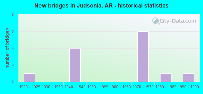
- New bridges - historical statistics
- 11920-1929
- 41940-1949
- 61970-1979
- 11980-1989
- 11990-1999


- Bridge Condition - Deck
- 55.6%Good
- 22.2%Satisfactory
- 22.2%Fair

- Bridge Condition - Superstructure
- 55.6%Good
- 22.2%Satisfactory
- 11.1%Fair
- 11.1%Serious

- Bridge Condition - Substructure
- 33.3%Good
- 44.4%Satisfactory
- 22.2%Fair

- Bridge Condition - Channel
- 11.1%Very good
- 55.6%Good
- 33.3%Satisfactory

- Bridge Condition - Culverts
- 50.0%Good
- 25.0%Satisfactory
- 25.0%Fair
Find on map >> Show street view
Structure Number: 2216, Location: 1.0 M E OF SH 367 (Lat: 35.268908, Lng: -91.647839), Route carried "on" structure: State highway 385, Year Built: 1948, Status: Open, Structure Length: 3.35m (10.99ft), Average Daily Traffic: 1,700 (year 2018), Truck Traffic: 1%, Average Future Daily Traffic: 3,117 (year 2028), Design Load: H 20, Features Intersected: CORLEY BRANCH
Minimum Vertical Clearance: 30+ m (98+ ft), Kilometerpoint: 2.334, Lanes on structure: 2, Owner: State Highway Agency, Approaching Roadway Width: 7.3m (24.0ft), Material/Design: Steel, Design/Construction: Stringer/Multi-beam, Number Of Spans In Main Unit: 3, Length of Maximum Span: 11.0m (36.1ft), Curb or Sidewalk Widths: Left: 0.6m (2.0ft), Right: 0.6m (2.0ft), Curb-To-Curb Width: 7.9m (25.9ft), Out-to-Out Width: 9.4m (30.8ft)
Condition: Deck: Fair, Superstructure: Fair, Substructure: Fair, Channel: Satisfactory, Operating Rating: 42.6 metric tons, Method Used To Determine Operating Rating: Load Factor (LF), Inventory Rating: 25.4 metric tons, Method Used To Determine Inventory Rating: Load Factor (LF), Structural Evaluation: Somewhat better than minimum adequacy, Deck Geometry: Meets minimum limits, Waterway Adequacy: Better than present minimum criteria, Approach Roadway Alignment: Better than present minimum criteria, Designated Inspection Frequency: Every 24 months, Critical Feature Inspection Frequency: Every 24 months, Inspection Date: August 2020, Deck Structure Type: Concrete Cast-file-Place, Wearing Surface/Protective System: Wearing Surface: Monolithic Concrete
Find on map >> Show street view
Structure Number: 4784, Location: .57 MI N CR 383 & SH 157 (Lat: 35.320353, Lng: -91.642578), Route carried "on" structure: County highway 383, Year Built: 1998, Status: Open, Structure Length: 2.83m (9.28ft), Average Daily Traffic: 801 (year 2018), Truck Traffic: 1%, Average Future Daily Traffic: 346 (year 2016), Design Load: HS 20, Features Intersected: FLAT CREEK
Minimum Vertical Clearance: 30+ m (98+ ft), Kilometerpoint: 0.917, Lanes on structure: 2, Owner: County Highway Agency, Approaching Roadway Width: 8.5m (27.9ft), Skew: 3 degrees, Material/Design: Concrete, Design/Construction: Channel Beam, Number Of Spans In Main Unit: 3, Length of Maximum Span: 9.4m (30.8ft), Curb-To-Curb Width: 7.3m (24.0ft), Out-to-Out Width: 8.2m (26.9ft)
Condition: Deck: Good, Superstructure: Good, Substructure: Good, Channel: Very good, Operating Rating: 54.4 metric tons, Method Used To Determine Operating Rating: Load Factor (LF), Inventory Rating: 32.7 metric tons, Method Used To Determine Inventory Rating: Load Factor (LF), Structural Evaluation: Better than present minimum criteria, Deck Geometry: Meets minimum limits, Waterway Adequacy: Better than present minimum criteria, Approach Roadway Alignment: Better than present minimum criteria, Designated Inspection Frequency: Every 24 months, Critical Feature Inspection Frequency: Every 24 months, Inspection Date: August 2020, Deck Structure Type: Concrete Cast-file-Place, Wearing Surface/Protective System: Wearing Surface: Monolithic Concrete
Find on map >> Show street view
Structure Number: 5537, Location: JCT OF SH 385 & US 67 (Lat: 35.268731, Lng: -91.672781), Route carried "on" structure: State highway 385, Year Built: 1976, Status: Open, Structure Length: 7.62m (25.00ft), Average Daily Traffic: 4,893 (year 2018), Truck Traffic: 1%, Average Future Daily Traffic: 9,622 (year 2028), Design Load: HS 20, Features Intersected: US 67-SEC 13
Minimum Vertical Clearance: 30+ m (98+ ft), Kilometerpoint: 4.714, Lanes on structure: 2, Lanes under structure: 4, Owner: State Highway Agency, Approaching Roadway Width: 13.4m (44.0ft), Skew: 2 degrees, Material/Design: Steel continuous, Design/Construction: Stringer/Multi-beam, Number Of Spans In Main Unit: 2, Length of Maximum Span: 37.8m (124.0ft), Curb or Sidewalk Widths: Left: 0.5m (1.6ft), Right: 0.5m (1.6ft), Curb-To-Curb Width: 13.1m (43.0ft), Out-to-Out Width: 14.0m (45.9ft)
Condition: Deck: Satisfactory, Superstructure: Satisfactory, Substructure: Satisfactory, Operating Rating: 54.4 metric tons, Method Used To Determine Operating Rating: Load Factor (LF), Inventory Rating: 32.7 metric tons, Method Used To Determine Inventory Rating: Load Factor (LF), Structural Evaluation: Equal to present minimum criteria, Deck Geometry: Equal to present minimum criteria, Underclear: Equal to present desirable criteria, Approach Roadway Alignment: Equal to present desirable criteria, Designated Inspection Frequency: Every 24 months, Critical Feature Inspection Frequency: Every 24 months, Inspection Date: March 2020, Deck Structure Type: Concrete Cast-file-Place, Wearing Surface/Protective System: Wearing Surface: Monolithic Concrete
Find on map >> Show street view
Structure Number: 5538, Location: 0.98 MI W JCT SH 367 (Lat: 35.283650, Lng: -91.658097), Route carried "on" structure: State highway 13, Year Built: 1976, Status: Open, Structure Length: 6.43m (21.10ft), Average Daily Traffic: 834 (year 2018), Truck Traffic: 4%, Average Future Daily Traffic: 1,179 (year 2028), Design Load: HS 20, Features Intersected: US 67
Minimum Vertical Clearance: 30+ m (98+ ft), Kilometerpoint: 1.416, Lanes on structure: 2, Lanes under structure: 4, Owner: State Highway Agency, Approaching Roadway Width: 10.4m (34.1ft), Material/Design: Steel continuous, Design/Construction: Stringer/Multi-beam, Number Of Spans In Main Unit: 2, Length of Maximum Span: 33.5m (109.9ft), Curb or Sidewalk Widths: Left: 0.2m (0.7ft), Right: 0.2m (0.7ft), Curb-To-Curb Width: 10.4m (34.1ft), Out-to-Out Width: 11.3m (37.1ft)
Condition: Deck: Good, Superstructure: Good, Substructure: Satisfactory, Operating Rating: 54.4 metric tons, Method Used To Determine Operating Rating: Load Factor (LF), Inventory Rating: 32.7 metric tons, Method Used To Determine Inventory Rating: Load Factor (LF), Structural Evaluation: Equal to present minimum criteria, Deck Geometry: Equal to present minimum criteria, Underclear: Superior to present desirable criteria, Approach Roadway Alignment: Equal to present desirable criteria, Designated Inspection Frequency: Every 24 months, Critical Feature Inspection Frequency: Every 24 months, Inspection Date: Febuary 2022, Deck Structure Type: Concrete Cast-file-Place, Wearing Surface/Protective System: Wearing Surface: Monolithic Concrete
Find on map >> Show street view
Structure Number: 5567, Location: JCT SH 157 & US 67 (Lat: 35.299869, Lng: -91.635389), Route carried "on" structure: State highway 157, Year Built: 1976, Status: Open, Structure Length: 7.56m (24.80ft), Average Daily Traffic: 946 (year 2018), Truck Traffic: 4%, Average Future Daily Traffic: 1,220 (year 2028), Design Load: HS 20, Features Intersected: US 67-SEC 13
Minimum Vertical Clearance: 30+ m (98+ ft), Kilometerpoint: 1.899, Lanes on structure: 2, Lanes under structure: 4, Owner: State Highway Agency, Approaching Roadway Width: 13.4m (44.0ft), Material/Design: Steel continuous, Design/Construction: Stringer/Multi-beam, Number Of Spans In Main Unit: 2, Length of Maximum Span: 38.7m (127.0ft), Curb or Sidewalk Widths: Left: 0.2m (0.7ft), Right: 0.2m (0.7ft), Curb-To-Curb Width: 13.1m (43.0ft), Out-to-Out Width: 14.0m (45.9ft)
Condition: Deck: Satisfactory, Superstructure: Satisfactory, Substructure: Satisfactory, Operating Rating: 54.4 metric tons, Method Used To Determine Operating Rating: Load Factor (LF), Inventory Rating: 32.7 metric tons, Method Used To Determine Inventory Rating: Load Factor (LF), Structural Evaluation: Equal to present minimum criteria, Deck Geometry: Superior to present desirable criteria, Underclear: Superior to present desirable criteria, Approach Roadway Alignment: Equal to present desirable criteria, Designated Inspection Frequency: Every 24 months, Critical Feature Inspection Frequency: Every 24 months, Inspection Date: July 2020, Deck Structure Type: Concrete Cast-file-Place, Wearing Surface/Protective System: Wearing Surface: Monolithic Concrete
Find on map >> Show street view
Structure Number: 5568, Location: JCT SH 323 & US 67 (Lat: 35.305211, Lng: -91.624211), Route carried "on" structure: State highway 323, Year Built: 1976, Status: Open, Structure Length: 7.68m (25.20ft), Average Daily Traffic: 1,108 (year 2018), Truck Traffic: 1%, Average Future Daily Traffic: 1,165 (year 2028), Design Load: HS 20, Features Intersected: US 67-SEC 13
Minimum Vertical Clearance: 30+ m (98+ ft), Kilometerpoint: 3.780, Lanes on structure: 2, Lanes under structure: 4, Owner: State Highway Agency, Approaching Roadway Width: 8.5m (27.9ft), Skew: 3 degrees, Material/Design: Steel continuous, Design/Construction: Stringer/Multi-beam, Number Of Spans In Main Unit: 2, Length of Maximum Span: 39.6m (129.9ft), Curb or Sidewalk Widths: Left: 0.5m (1.6ft), Right: 0.5m (1.6ft), Curb-To-Curb Width: 8.5m (27.9ft), Out-to-Out Width: 9.4m (30.8ft)
Condition: Deck: Good, Superstructure: Good, Substructure: Good, Operating Rating: 54.4 metric tons, Method Used To Determine Operating Rating: Load Factor (LF), Inventory Rating: 32.7 metric tons, Method Used To Determine Inventory Rating: Load Factor (LF), Structural Evaluation: Better than present minimum criteria, Deck Geometry: Somewhat better than minimum adequacy, Underclear: Superior to present desirable criteria, Approach Roadway Alignment: Equal to present desirable criteria, Designated Inspection Frequency: Every 24 months, Critical Feature Inspection Frequency: Every 24 months, Inspection Date: October 2021, Deck Structure Type: Concrete Cast-file-Place, Wearing Surface/Protective System: Wearing Surface: Monolithic Concrete
Find on map >> Show street view
Structure Number: 6081, Location: .8 MI N SH 137 (Lat: 35.325150, Lng: -91.659731), Route carried "on" structure: State highway 13, Year Built: 1985, Status: Open, Structure Length: 5.33m (17.49ft), Average Daily Traffic: 620 (year 2018), Truck Traffic: 2%, Average Future Daily Traffic: 718 (year 2028), Design Load: H 20, Features Intersected: FLAT CREEK
Minimum Vertical Clearance: 30+ m (98+ ft), Kilometerpoint: 6.468, Lanes on structure: 2, Owner: State Highway Agency, Approaching Roadway Width: 8.5m (27.9ft), Skew: 4 degrees, Material/Design: Concrete, Design/Construction: Slab, Number Of Spans In Main Unit: 5, Length of Maximum Span: 10.7m (35.1ft), Curb-To-Curb Width: 8.5m (27.9ft), Out-to-Out Width: 9.4m (30.8ft)
Condition: Deck: Good, Superstructure: Good, Substructure: Good, Channel: Good, Operating Rating: 50.8 metric tons, Method Used To Determine Operating Rating: Load Factor (LF), Inventory Rating: 30.8 metric tons, Method Used To Determine Inventory Rating: Load Factor (LF), Structural Evaluation: Better than present minimum criteria, Deck Geometry: Somewhat better than minimum adequacy, Waterway Adequacy: Equal to present desirable criteria, Approach Roadway Alignment: Equal to present desirable criteria, Designated Inspection Frequency: Every 24 months, Critical Feature Inspection Frequency: Every 24 months, Inspection Date: Febuary 2022, Deck Structure Type: Concrete Cast-file-Place, Wearing Surface/Protective System: Wearing Surface: Monolithic Concrete
Find on map >> Show street view
Structure Number: 17484, Location: .25MI SO OF 385 @ JUDSONI (Lat: 35.267794, Lng: -91.639814), Route carried "on" structure: County highway 66, Year Built: 1924, Status: Posted for load, Structure Length: 12.10m (39.70ft), Average Daily Traffic: 67 (year 2018), Truck Traffic: 1%, Average Future Daily Traffic: 225 (year 2007), Features Intersected: LITTLE RED RIVER
Minimum Vertical Clearance: 4.78m (15.68ft), Kilometerpoint: 0.177, Lanes on structure: 1, Owner: County Highway Agency, Approaching Roadway Width: 6.7m (22.0ft), Material/Design: Steel continuous, Design/Construction: Truss - Thru, Number Of Spans In Main Unit: 2, Number Of Approach Spans: 2, Length of Maximum Span: 40.5m (132.9ft), Curb or Sidewalk Widths: Left: 0.2m (0.7ft), Right: 0.2m (0.7ft), Curb-To-Curb Width: 4.1m (13.5ft), Out-to-Out Width: 4.9m (16.1ft)
Condition: Deck: Fair, Superstructure: Serious, Substructure: Fair, Channel: Good, Operating Rating: 9.1 metric tons, Method Used To Determine Operating Rating: Load Factor (LF), Inventory Rating: 5.4 metric tons, Method Used To Determine Inventory Rating: Load Factor (LF), Structural Evaluation: High priority of replacement, Deck Geometry: Somewhat better than minimum adequacy, Waterway Adequacy: Equal to present desirable criteria, Approach Roadway Alignment: Somewhat better than minimum adequacy, Bridge Posting: Required (Relationship of Operating Rating to Maximum Legal Load: > 39.9% below), Length Of Structure Improvement: 13.26m (43.50ft), Designated Inspection Frequency: Every 24 months, Critical Feature Inspection Frequency: Every 24 months, Inspection Date: Febuary 2022, Critical Feature Inspection Date: Febuary 2022, Roadway Improvement Cost: $109,000, Total Project Cost: $744,000, Deck Structure Type: Wood or Timber, Wearing Surface/Protective System: Wearing Surface: Wood or Timber
Find on map >> Show street view
Structure Number: M1242, Location: 0.1 MI W JCT SH 371 & 67 (Lat: 35.282531, Lng: -91.642700), Route carried "on" structure: State highway 367, Year Built: 1949, Status: Open, Structure Length: 0.67m (2.20ft), Average Daily Traffic: 5,970 (year 2018), Truck Traffic: 1%, Average Future Daily Traffic: 8,944 (year 2028), Design Load: H 20, Features Intersected: DITCH
Minimum Vertical Clearance: 30+ m (98+ ft), Kilometerpoint: 5.148, Lanes on structure: 2, Owner: State Highway Agency, Approaching Roadway Width: 12.8m (42.0ft), Material/Design: Concrete, Design/Construction: Culvert, Number Of Spans In Main Unit: 2, Length of Maximum Span: 3.0m (9.8ft)
Condition: Channel: Good, Culverts: Good, Operating Rating: 35.4 metric tons, Method Used To Determine Operating Rating: Load Factor (LF), Inventory Rating: 21.8 metric tons, Method Used To Determine Inventory Rating: Load Factor (LF), Structural Evaluation: Somewhat better than minimum adequacy, Waterway Adequacy: Equal to present desirable criteria, Approach Roadway Alignment: Equal to present desirable criteria, Designated Inspection Frequency: Every 24 months, Critical Feature Inspection Frequency: Every 24 months, Inspection Date: December 2021
Find on map >> Show street view
Structure Number: M1243, Location: JCT SH 367 & 371 (Lat: 35.283089, Lng: -91.638519), Route carried "on" structure: State highway 367, Year Built: 1949, Status: Open, Structure Length: 0.64m (2.10ft), Average Daily Traffic: 6,023 (year 2018), Truck Traffic: 1%, Average Future Daily Traffic: 9,350 (year 2028), Design Load: H 20, Features Intersected: CORN STALK BROOK
Minimum Vertical Clearance: 30+ m (98+ ft), Kilometerpoint: 5.486, Lanes on structure: 2, Owner: State Highway Agency, Approaching Roadway Width: 25.9m (85.0ft), Material/Design: Concrete, Design/Construction: Culvert, Number Of Spans In Main Unit: 2, Length of Maximum Span: 3.0m (9.8ft)
Condition: Channel: Satisfactory, Culverts: Good, Operating Rating: 39.9 metric tons, Method Used To Determine Operating Rating: Load Factor (LF), Inventory Rating: 23.6 metric tons, Method Used To Determine Inventory Rating: Load Factor (LF), Structural Evaluation: Somewhat better than minimum adequacy, Waterway Adequacy: Equal to present desirable criteria, Approach Roadway Alignment: Equal to present desirable criteria, Designated Inspection Frequency: Every 24 months, Critical Feature Inspection Frequency: Every 24 months, Inspection Date: December 2021
Find on map >> Show street view
Structure Number: M288, Location: 1.1 MI N JCT US 67 & 323 (Lat: 35.301939, Lng: -91.624300), Route carried "on" structure: State highway 323, Year Built: 1940, Status: Open, Structure Length: 0.79m (2.59ft), Average Daily Traffic: 1,300 (year 2018), Truck Traffic: 1%, Average Future Daily Traffic: 1,762 (year 2028), Design Load: H 10, Features Intersected: CREEK
Minimum Vertical Clearance: 30+ m (98+ ft), Kilometerpoint: 3.426, Lanes on structure: 2, Owner: State Highway Agency, Approaching Roadway Width: 7.9m (25.9ft), Material/Design: Concrete, Design/Construction: Culvert, Number Of Spans In Main Unit: 5, Length of Maximum Span: 1.2m (3.9ft)
Condition: Channel: Good, Culverts: Fair, Operating Rating: 33.6 metric tons, Method Used To Determine Operating Rating: Load Factor (LF), Inventory Rating: 20.0 metric tons, Method Used To Determine Inventory Rating: Load Factor (LF), Structural Evaluation: Somewhat better than minimum adequacy, Waterway Adequacy: Better than present minimum criteria, Approach Roadway Alignment: Equal to present desirable criteria, Designated Inspection Frequency: Every 24 months, Critical Feature Inspection Frequency: Every 24 months, Inspection Date: August 2021
Find on map >> Show street view
Structure Number: M3231, Location: 1.7 MI N US 67 (Lat: 35.310350, Lng: -91.624100), Route carried "on" structure: State highway 323, Year Built: 1970, Status: Open, Structure Length: 1.89m (6.20ft), Average Daily Traffic: 940 (year 2018), Truck Traffic: 1%, Average Future Daily Traffic: 1,150 (year 2034), Design Load: H 15, Features Intersected: FLAT CREEK
Minimum Vertical Clearance: 30+ m (98+ ft), Kilometerpoint: 4.394, Lanes on structure: 2, Owner: State Highway Agency, Approaching Roadway Width: 8.2m (26.9ft), Skew: 4 degrees, Material/Design: Concrete, Design/Construction: Channel Beam, Number Of Spans In Main Unit: 2, Length of Maximum Span: 9.4m (30.8ft), Curb or Sidewalk Widths: Left: 0.3m (1.0ft), Right: 0.3m (1.0ft), Curb-To-Curb Width: 8.0m (26.2ft), Out-to-Out Width: 8.6m (28.2ft)
Condition: Deck: Good, Superstructure: Good, Substructure: Satisfactory, Channel: Satisfactory, Operating Rating: 39.0 metric tons, Method Used To Determine Operating Rating: Load Factor (LF), Inventory Rating: 23.6 metric tons, Method Used To Determine Inventory Rating: Load Factor (LF), Structural Evaluation: Equal to present minimum criteria, Deck Geometry: Somewhat better than minimum adequacy, Waterway Adequacy: Equal to present desirable criteria, Approach Roadway Alignment: Equal to present desirable criteria, Designated Inspection Frequency: Every 24 months, Critical Feature Inspection Frequency: Every 24 months, Inspection Date: June 2020, Deck Structure Type: Concrete Cast-file-Place, Wearing Surface/Protective System: Wearing Surface: Bituminous
Find on map >> Show street view
Structure Number: X0312, Location: 0.23 MI NE JCT SH 323 (Lat: 35.307228, Lng: -91.620603), Route carried "on" structure: US 67, Year Built: 1976, Status: Open, Structure Length: 1.19m (3.90ft), Average Daily Traffic: 21,000 (year 2018), Truck Traffic: 17%, Average Future Daily Traffic: 27,300 (year 2038), Design Load: H 20, Features Intersected: FLAT CREEK
Minimum Vertical Clearance: 30+ m (98+ ft), Kilometerpoint: 8.996, Lanes on structure: 4, Base Highway Network: Yes, Owner: State Highway Agency, Approaching Roadway Width: 8.5m (27.9ft), Skew: 21 degrees, Material/Design: Concrete, Design/Construction: Culvert, Number Of Spans In Main Unit: 3, Length of Maximum Span: 4.0m (13.1ft)
Condition: Channel: Good, Culverts: Satisfactory, Operating Rating: 54.4 metric tons, Method Used To Determine Operating Rating: Load Factor (LF), Inventory Rating: 32.7 metric tons, Method Used To Determine Inventory Rating: Load Factor (LF), Structural Evaluation: Equal to present minimum criteria, Waterway Adequacy: Equal to present desirable criteria, Approach Roadway Alignment: Equal to present desirable criteria, Designated Inspection Frequency: Every 24 months, Critical Feature Inspection Frequency: Every 24 months, Inspection Date: April 2020
Find on map >> Show street view
Structure Number: 5537, Location: JCT OF SH 385 & US 67 (Lat: 35.268731, Lng: -91.672781), Route carried "under" structure: US 67, Structure Length: 0. m, Average Daily Traffic: 11,500 (year 2014), Truck Traffic: 1%, Features Intersected: US 67-SEC 13, Facility Carried by Structure: SH 385 WHITE CO.
Minimum Vertical Clearance: 5.15m (16.90ft), Kilometerpoint: 2.494, Length of Maximum Span: 0.0m
Find on map >> Show street view
Structure Number: 5537, Location: JCT OF SH 385 & US 67 (Lat: 35.268731, Lng: -91.672781), Route carried "under" structure: US 67, Structure Length: 0. m, Average Daily Traffic: 11,500 (year 2014), Truck Traffic: 1%, Features Intersected: US 67-SEC 13, Facility Carried by Structure: SH 385 WHITE CO.
Minimum Vertical Clearance: 5.05m (16.57ft), Kilometerpoint: 2.494, Length of Maximum Span: 0.0m
Find on map >> Show street view
Structure Number: 5538, Location: 0.98 MI W JCT SH 367 (Lat: 35.283650, Lng: -91.658097), Route carried "under" structure: US 67, Structure Length: 0. m, Average Daily Traffic: 10,000 (year 2014), Truck Traffic: 1%, Features Intersected: US 67, Facility Carried by Structure: SH 13 WHITE COUNTY
Minimum Vertical Clearance: 5.10m (16.73ft), Kilometerpoint: 4.635, Length of Maximum Span: 0.0m
Find on map >> Show street view
Structure Number: 5538, Location: 0.98 MI W JCT SH 367 (Lat: 35.283650, Lng: -91.658097), Route carried "under" structure: US 67, Structure Length: 0. m, Average Daily Traffic: 10,000 (year 2014), Truck Traffic: 1%, Features Intersected: US 67, Facility Carried by Structure: SH 13 WHITE COUNTY
Minimum Vertical Clearance: 5.63m (18.47ft), Kilometerpoint: 4.635, Length of Maximum Span: 0.0m
Find on map >> Show street view
Structure Number: 5567, Location: JCT SH 157 & US 67 (Lat: 35.299869, Lng: -91.635389), Route carried "under" structure: US 67, Structure Length: 0. m, Average Daily Traffic: 10,000 (year 2014), Truck Traffic: 1%, Features Intersected: US 67-SEC 13, Facility Carried by Structure: SH 157 OP WHITE
Minimum Vertical Clearance: 5.24m (17.19ft), Kilometerpoint: 7.435, Length of Maximum Span: 0.0m
Find on map >> Show street view
Structure Number: 5567, Location: JCT SH 157 & US 67 (Lat: 35.299869, Lng: -91.635389), Route carried "under" structure: US 67, Structure Length: 0. m, Average Daily Traffic: 10,000 (year 2014), Truck Traffic: 1%, Features Intersected: US 67-SEC 13, Facility Carried by Structure: SH 157 OP WHITE
Minimum Vertical Clearance: 5.21m (17.09ft), Kilometerpoint: 7.435, Length of Maximum Span: 0.0m
Find on map >> Show street view
Structure Number: 5568, Location: JCT SH 323 & US 67 (Lat: 35.305211, Lng: -91.624211), Route carried "under" structure: US 67, Structure Length: 0. m, Average Daily Traffic: 9,500 (year 2013), Truck Traffic: 1%, Features Intersected: US 67-SEC 13, Facility Carried by Structure: SH 323 OP White Co
Minimum Vertical Clearance: 5.51m (18.08ft), Kilometerpoint: 8.626, Length of Maximum Span: 0.0m
Find on map >> Show street view
Structure Number: 5568, Location: JCT SH 323 & US 67 (Lat: 35.305211, Lng: -91.624211), Route carried "under" structure: US 67, Structure Length: 0. m, Average Daily Traffic: 9,500 (year 2013), Truck Traffic: 1%, Features Intersected: US 67-SEC 13, Facility Carried by Structure: SH 323 OP White Co
Minimum Vertical Clearance: 5.18m (16.99ft), Kilometerpoint: 8.626, Length of Maximum Span: 0.0m