Bridge Statistics for Junction City, Georgia (GA)
Condition, Traffic, Stress, Structural Evaluation, Project Costs
- National Bridge Inventory (NBI) Statistics
- 11Number of bridges
- 89ft / 26.7mTotal length
- $5,050,000Total costs
- 20,790Total average daily traffic
- 200Total average daily truck traffic
- National Bridge Inventory (NBI) Registered Bridges for Junction City
- No street view available for this location
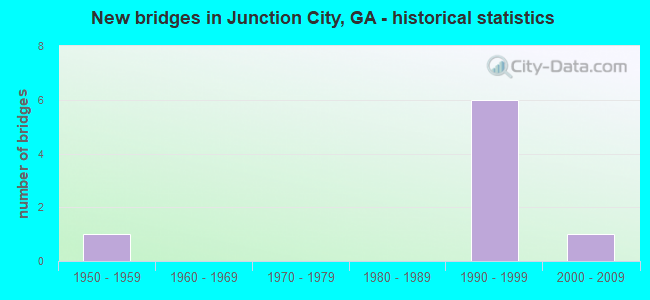
- New bridges - historical statistics
- 11950-1959
- 61990-1999
- 12000-2009


- Bridge Condition - Deck
- 80.0%Good
- 20.0%Satisfactory

- Bridge Condition - Superstructure
- 20.0%Very good
- 80.0%Good

- Bridge Condition - Channel
- 33.3%Good
- 33.3%Satisfactory
- 33.3%Fair

- Bridge Condition - Culverts
- 33.3%Very good
- 66.7%Good
Find on map >> Show street view
Structure Number: 2630032, Location: 2 MI S OF MANCHESTER (Lat: 32.818089, Lng: -84.646139), Route carried "on" structure: Alternate US 27, Year Built: 1991, Status: Open, Structure Length: 1.13m (3.71ft), Average Daily Traffic: 1,610 (year 2012), Truck Traffic: 1%, Average Future Daily Traffic: 2,415 (year 2032), Design Load: HS 20+Mod, Features Intersected: LAZAR CREEK
Minimum Vertical Clearance: 30+ m (98+ ft), Kilometerpoint: 6.437, Lanes on structure: 2, Base Highway Network: Yes, Owner: State Highway Agency, Approaching Roadway Width: 7.3m (24.0ft), Skew: 3 degrees, Material/Design: Concrete, Design/Construction: Culvert, Number Of Spans In Main Unit: 3, Length of Maximum Span: 3.7m (12.1ft)
Condition: Channel: Fair, Culverts: Good, Operating Rating: 89.8 metric tons, Method Used To Determine Operating Rating: Field evaluation and documented engineering judgment, Inventory Rating: 89.8 metric tons, Method Used To Determine Inventory Rating: Field evaluation and documented engineering judgment, Structural Evaluation: Better than present minimum criteria, Waterway Adequacy: Equal to present desirable criteria, Approach Roadway Alignment: Equal to present desirable criteria, Designated Inspection Frequency: Every 24 months, Inspection Date: January 2021, Bridge Improvement Cost: $145,000, Roadway Improvement Cost: $14,000, Total Project Cost: $217,000
Find on map >> Show street view
Structure Number: 2635056, Location: 1.9 MI N OF JUNCTION CITY (Lat: 32.622419, Lng: -84.434678), Route carried "on" structure: County highway 175, Year Built: 1955, Status: Open, Structure Length: 0.98m (3.22ft), Average Daily Traffic: 490 (year 2012), Truck Traffic: 1%, Average Future Daily Traffic: 735 (year 2032), Design Load: H 15, Features Intersected: PATSILIGA CREEK, Facility Carried by Structure: BUCKNER ROAD
Minimum Vertical Clearance: 30+ m (98+ ft), Kilometerpoint: 3.219, Lanes on structure: 2, Base Highway Network: Yes, Owner: County Highway Agency, Approaching Roadway Width: 6.7m (22.0ft), Material/Design: Concrete, Design/Construction: Culvert, Number Of Spans In Main Unit: 3, Length of Maximum Span: 3.0m (9.8ft)
Condition: Channel: Satisfactory, Culverts: Good, Operating Rating: 41.7 metric tons, Method Used To Determine Operating Rating: Field evaluation and documented engineering judgment, Inventory Rating: 24.4 metric tons, Method Used To Determine Inventory Rating: Field evaluation and documented engineering judgment, Structural Evaluation: Equal to present minimum criteria, Waterway Adequacy: Better than present minimum criteria, Approach Roadway Alignment: Equal to present minimum criteria, Designated Inspection Frequency: Every 24 months, Inspection Date: January 2021, Bridge Improvement Cost: $125,000, Roadway Improvement Cost: $13,000, Total Project Cost: $188,000
Find on map >> Show street view
Structure Number: 2635062, Location: 6 MI N OF JUNCTION CITY (Lat: 32.694478, Lng: -84.444628), Route carried "on" structure: County highway 113, Year Built: 1995, Status: Posted for load, Structure Length: 1.52m (4.99ft), Average Daily Traffic: 50 (year 2012), Truck Traffic: 1%, Average Future Daily Traffic: 75 (year 2032), Features Intersected: RICHLAND CREEK, Facility Carried by Structure: JAMES POSEY
Minimum Vertical Clearance: 30+ m (98+ ft), Kilometerpoint: 11.265, Lanes on structure: 1, Base Highway Network: Yes, Owner: County Highway Agency, Approaching Roadway Width: 4.6m (15.1ft), Material/Design: Steel, Design/Construction: Stringer/Multi-beam, Number Of Spans In Main Unit: 1, Length of Maximum Span: 15.2m (49.9ft), Curb-To-Curb Width: 4.2m (13.8ft), Out-to-Out Width: 4.3m (14.1ft)
Condition: Deck: Satisfactory, Superstructure: Good, Substructure: Good, Channel: Good, Operating Rating: 25.4 metric tons, Method Used To Determine Operating Rating: Load Factor (LF), Inventory Rating: 15.4 metric tons, Method Used To Determine Inventory Rating: Load Factor (LF), Structural Evaluation: Meets minimum limits, Deck Geometry: Somewhat better than minimum adequacy, Waterway Adequacy: Equal to present minimum criteria, Approach Roadway Alignment: Meets minimum limits, Bridge Posting: Required (Relationship of Operating Rating to Maximum Legal Load: 20.0 - 29.9% below), Designated Inspection Frequency: Every 24 months, Inspection Date: January 2021, Bridge Improvement Cost: $142,000, Roadway Improvement Cost: $14,000, Total Project Cost: $213,000, Deck Structure Type: Wood or Timber, Wearing Surface/Protective System: Wearing Surface: Wood or Timber
Find on map >> Show street view
Structure Number: 2635066, Location: SOUTH JUNCTION CITY (Lat: 32.597050, Lng: -84.452950), Route carried "on" structure: State highway 90, Year Built: 1999, Status: Open, Structure Length: 5.12m (16.80ft), Average Daily Traffic: 4,170 (year 2012), Truck Traffic: 1%, Average Future Daily Traffic: 6,255 (year 2032), Design Load: HS 20+Mod, Features Intersected: CSX RAILROAD
Minimum Vertical Clearance: 30+ m (98+ ft), Kilometerpoint: 4.828, Lanes on structure: 2, Base Highway Network: Yes, Owner: State Highway Agency, Approaching Roadway Width: 10.4m (34.1ft), Skew: 11 degrees, Material/Design: Prestressed concrete, Design/Construction: Stringer/Multi-beam, Number Of Spans In Main Unit: 3, Length of Maximum Span: 17.1m (56.1ft), Curb-To-Curb Width: 11.6m (38.1ft), Out-to-Out Width: 12.6m (41.3ft)
Condition: Deck: Good, Superstructure: Good, Substructure: Good, Operating Rating: 87.0 metric tons, Method Used To Determine Operating Rating: Load Factor (LF), Inventory Rating: 51.7 metric tons, Method Used To Determine Inventory Rating: Load Factor (LF), Structural Evaluation: Better than present minimum criteria, Deck Geometry: Better than present minimum criteria, Underclear: Superior to present desirable criteria, Approach Roadway Alignment: Better than present minimum criteria, Designated Inspection Frequency: Every 24 months, Inspection Date: January 2021, Bridge Improvement Cost: $656,000, Roadway Improvement Cost: $66,000, Total Project Cost: $985,000, Deck Structure Type: Concrete Cast-file-Place
Find on map >> Show street view
Structure Number: 2635067, Location: SOUTH JUNCTION CITY (Lat: 32.597258, Lng: -84.453028), Route carried "on" structure: State highway 90, Year Built: 1999, Status: Open, Structure Length: 5.12m (16.80ft), Average Daily Traffic: 4,170 (year 2012), Truck Traffic: 1%, Average Future Daily Traffic: 6,255 (year 2032), Design Load: HS 20+Mod, Features Intersected: CSX RAILROAD
Minimum Vertical Clearance: 30+ m (98+ ft), Kilometerpoint: 4.828, Lanes on structure: 2, Base Highway Network: Yes, Owner: State Highway Agency, Approaching Roadway Width: 10.4m (34.1ft), Skew: 11 degrees, Material/Design: Prestressed concrete, Design/Construction: Stringer/Multi-beam, Number Of Spans In Main Unit: 3, Length of Maximum Span: 17.1m (56.1ft), Curb-To-Curb Width: 11.6m (38.1ft), Out-to-Out Width: 12.6m (41.3ft)
Condition: Deck: Good, Superstructure: Very good, Substructure: Good, Operating Rating: 87.0 metric tons, Method Used To Determine Operating Rating: Load Factor (LF), Inventory Rating: 51.7 metric tons, Method Used To Determine Inventory Rating: Load Factor (LF), Structural Evaluation: Better than present minimum criteria, Deck Geometry: Better than present minimum criteria, Underclear: Superior to present desirable criteria, Approach Roadway Alignment: Better than present minimum criteria, Designated Inspection Frequency: Every 24 months, Inspection Date: January 2021, Bridge Improvement Cost: $656,000, Roadway Improvement Cost: $66,000, Total Project Cost: $985,000, Deck Structure Type: Concrete Cast-file-Place
Find on map >> Show street view
Structure Number: 2635068, Location: JUNCTION CITY (Lat: 32.606947, Lng: -84.476008), Route carried "on" structure: State highway 90, Year Built: 1998, Status: Open, Structure Length: 6.00m (19.69ft), Average Daily Traffic: 4,170 (year 2012), Truck Traffic: 1%, Average Future Daily Traffic: 6,255 (year 2032), Design Load: HS 20+Mod, Features Intersected: CSX RAILROAD
Minimum Vertical Clearance: 30+ m (98+ ft), Kilometerpoint: 6.437, Lanes on structure: 2, Base Highway Network: Yes, Owner: State Highway Agency, Approaching Roadway Width: 10.4m (34.1ft), Skew: 12 degrees, Material/Design: Prestressed concrete, Design/Construction: Stringer/Multi-beam, Number Of Spans In Main Unit: 3, Length of Maximum Span: 21.0m (68.9ft), Curb-To-Curb Width: 11.6m (38.1ft), Out-to-Out Width: 12.6m (41.3ft)
Condition: Deck: Good, Superstructure: Good, Substructure: Good, Operating Rating: 59.8 metric tons, Method Used To Determine Operating Rating: Load Factor (LF), Inventory Rating: 35.3 metric tons, Method Used To Determine Inventory Rating: Load Factor (LF), Structural Evaluation: Better than present minimum criteria, Deck Geometry: Better than present minimum criteria, Underclear: Superior to present desirable criteria, Approach Roadway Alignment: Equal to present minimum criteria, Designated Inspection Frequency: Every 24 months, Inspection Date: January 2021, Bridge Improvement Cost: $770,000, Roadway Improvement Cost: $77,000, Total Project Cost: $1,155,000, Deck Structure Type: Concrete Cast-file-Place
Find on map >> Show street view
Structure Number: 2635069, Location: JUNCTION CITY (Lat: 32.606819, Lng: -84.476258), Route carried "on" structure: State highway 90, Year Built: 1998, Status: Open, Structure Length: 6.00m (19.69ft), Average Daily Traffic: 4,170 (year 2012), Truck Traffic: 1%, Average Future Daily Traffic: 6,255 (year 2032), Design Load: HS 20+Mod, Features Intersected: CSX RAILROAD
Minimum Vertical Clearance: 30+ m (98+ ft), Kilometerpoint: 6.437, Lanes on structure: 2, Base Highway Network: Yes, Owner: State Highway Agency, Approaching Roadway Width: 10.4m (34.1ft), Skew: 13 degrees, Material/Design: Prestressed concrete, Design/Construction: Stringer/Multi-beam, Number Of Spans In Main Unit: 3, Length of Maximum Span: 21.0m (68.9ft), Curb-To-Curb Width: 11.6m (38.1ft), Out-to-Out Width: 12.6m (41.3ft)
Condition: Deck: Good, Superstructure: Good, Substructure: Good, Operating Rating: 59.8 metric tons, Method Used To Determine Operating Rating: Load Factor (LF), Inventory Rating: 28.1 metric tons, Method Used To Determine Inventory Rating: Load Factor (LF), Structural Evaluation: Better than present minimum criteria, Deck Geometry: Better than present minimum criteria, Underclear: Superior to present desirable criteria, Approach Roadway Alignment: Equal to present minimum criteria, Designated Inspection Frequency: Every 24 months, Inspection Date: January 2021, Bridge Improvement Cost: $770,000, Roadway Improvement Cost: $77,000, Total Project Cost: $1,155,000, Deck Structure Type: Concrete Cast-file-Place
Find on map >> Show street view
Structure Number: 2635078, Location: IN JUNCTION CITY (Lat: 32.611339, Lng: -84.476469), Route carried "on" structure: County highway 121, Year Built: 2001, Status: Open, Structure Length: 0.79m (2.59ft), Average Daily Traffic: 490 (year 2012), Truck Traffic: 1%, Average Future Daily Traffic: 735 (year 2032), Design Load: H 15, Features Intersected: CSX RAILROAD
Minimum Vertical Clearance: 30+ m (98+ ft), Kilometerpoint: 0.000, Lanes on structure: 2, Base Highway Network: Yes, Owner: County Highway Agency, Approaching Roadway Width: 7.3m (24.0ft), Material/Design: Steel, Design/Construction: Culvert, Number Of Spans In Main Unit: 1, Length of Maximum Span: 7.9m (25.9ft)
Condition: Culverts: Very good, Operating Rating: 40.8 metric tons, Method Used To Determine Operating Rating: Field evaluation and documented engineering judgment, Inventory Rating: 24.4 metric tons, Method Used To Determine Inventory Rating: Field evaluation and documented engineering judgment, Structural Evaluation: Equal to present minimum criteria, Underclear: Meets minimum limits, Approach Roadway Alignment: Better than present minimum criteria, Designated Inspection Frequency: Every 24 months, Inspection Date: January 2021, Bridge Improvement Cost: $102,000, Roadway Improvement Cost: $10,000, Total Project Cost: $152,000
Find on map >> Show street view
Structure Number: 2630031, Location: IN JUNCTION CITY (Lat: 32.603344, Lng: -84.459578), Route carried "under" structure: City street 659, Structure Length: 0. m, Average Daily Traffic: 490 (year 2012), Truck Traffic: 1%, Features Intersected: CS 659, Facility Carried by Structure: CSX RAILROAD
Minimum Vertical Clearance: 4.29m (14.07ft), Kilometerpoint: 1.609, Length of Maximum Span: 0.0m
Find on map >> Show street view
Structure Number: 263506, Location: .2 MI NW OF JUNCTION CTY (Lat: 32.617228, Lng: -84.472169), Route carried "under" structure: County highway 120, Structure Length: 0. m, Average Daily Traffic: 490 (year 2012), Truck Traffic: 1%, Features Intersected: CR 120 ROCK CHURCH ROAD, Facility Carried by Structure: CSX RAILROAD
Minimum Vertical Clearance: 6.07m (19.91ft), Kilometerpoint: 1.609, Length of Maximum Span: 0.0m
Find on map >> Show street view
Structure Number: 2635077, Location: IN JUNCTION CITY (Lat: 32.604647, Lng: -84.459569), Route carried "under" structure: County highway 657, Structure Length: 0. m, Average Daily Traffic: 490 (year 2012), Truck Traffic: 1%, Features Intersected: TRUSSEL ST. & CSX RR, Facility Carried by Structure: CSX RAILROAD
Minimum Vertical Clearance: 7.44m (24.41ft), Kilometerpoint: 0.000, Length of Maximum Span: 0.0m