Bridge Statistics for Junius, New York (NY)
Condition, Traffic, Stress, Structural Evaluation, Project Costs
- National Bridge Inventory (NBI) Statistics
- 10Number of bridges
- 108ft / 32.8mTotal length
- $11,255,000Total costs
- 113,812Total average daily traffic
- 202Total average daily truck traffic
- National Bridge Inventory (NBI) Registered Bridges for Junius
- No street view available for this location
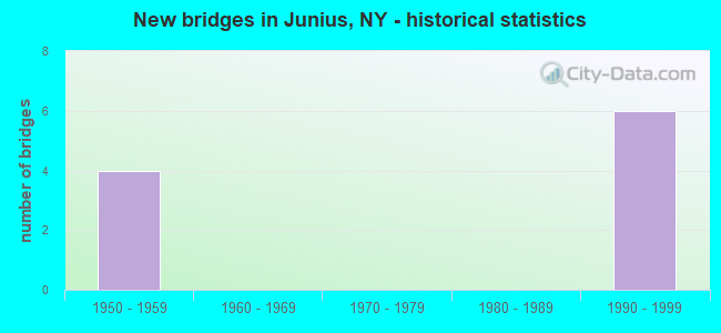
- New bridges - historical statistics
- 41950-1959
- 61990-1999


- Bridge Condition - Deck
- 20.0%Excellent
- 60.0%Very good
- 20.0%Satisfactory

- Bridge Condition - Superstructure
- 60.0%Very good
- 40.0%Good

- Bridge Condition - Substructure
- 80.0%Very good
- 20.0%Fair
Find on map >> Show street view
Structure Number: 551045, Location: 0.8 MI W OF EXIT 41 TOLL (Lat: 42.965408, Lng: -76.865203), Route carried "on" structure: County highway , Year Built: 1999, Status: Open, Structure Length: 6.16m (20.21ft), Average Daily Traffic: 722 (year 2018), Truck Traffic: 8%, Average Future Daily Traffic: 1,011 (year 2038), Design Load: HS 25 or greater, Features Intersected: 90IX EB, RTE I90, Facility Carried by Structure: BIRDSEY RD CR 106
Minimum Vertical Clearance: 30+ m (98+ ft), Kilometerpoint: 0.563, Lanes on structure: 2, Lanes under structure: 4, Owner: State Toll Authority, Approaching Roadway Width: 9.4m (30.8ft), Material/Design: Steel continuous, Design/Construction: Stringer/Multi-beam, Number Of Spans In Main Unit: 2, Length of Maximum Span: 30.5m (100.1ft), Curb-To-Curb Width: 9.6m (31.5ft), Out-to-Out Width: 10.4m (34.1ft)
Condition: Deck: Very good, Superstructure: Very good, Substructure: Very good, Operating Rating: 98.9 metric tons, Method Used To Determine Operating Rating: Load Factor (LF), Inventory Rating: 59.0 metric tons, Method Used To Determine Inventory Rating: Load Factor (LF), Structural Evaluation: Equal to present desirable criteria, Deck Geometry: Equal to present minimum criteria, Underclear: High priority of corrective action, Approach Roadway Alignment: Equal to present minimum criteria, Length Of Structure Improvement: 6.15m (20.18ft), Designated Inspection Frequency: Every 24 months, Inspection Date: September 2021, Bridge Improvement Cost: $1,368,000, Roadway Improvement Cost: $801,000, Total Project Cost: $2,169,000 ( Estimate for 2021), Deck Structure Type: Concrete Cast-file-Place, Wearing Surface/Protective System: Wearing Surface: Integral Concrete, Deck Protection: Galvanized Reinforcing
Find on map >> Show street view
Structure Number: 551046, Location: 2.0 MI W EXIT 41 I90 (Lat: 42.963939, Lng: -76.881558), Route carried "on" structure: Other road , Year Built: 1953, Year Reconstructed: 2016, Status: Open, Structure Length: 7.07m (23.20ft), Average Daily Traffic: 177 (year 2019), Truck Traffic: 8%, Average Future Daily Traffic: 248 (year 2039), Design Load: HS 20+Mod, Features Intersected: 90IX EB, RTE I90, Facility Carried by Structure: STONE CHURCH RD
Minimum Vertical Clearance: 30+ m (98+ ft), Kilometerpoint: 0.740, Lanes on structure: 2, Lanes under structure: 4, Owner: State Toll Authority, Approaching Roadway Width: 9.4m (30.8ft), Skew: 1 degrees, Material/Design: Steel continuous, Design/Construction: Stringer/Multi-beam, Number Of Spans In Main Unit: 4, Length of Maximum Span: 22.9m (75.1ft), Curb-To-Curb Width: 9.4m (30.8ft), Out-to-Out Width: 10.1m (33.1ft)
Condition: Deck: Satisfactory, Superstructure: Good, Substructure: Very good, Operating Rating: 58.1 metric tons, Method Used To Determine Operating Rating: Load Factor (LF), Inventory Rating: 32.7 metric tons, Method Used To Determine Inventory Rating: Load Factor (LF), Structural Evaluation: Better than present minimum criteria, Deck Geometry: Equal to present minimum criteria, Underclear: High priority of corrective action, Approach Roadway Alignment: Equal to present desirable criteria, Length Of Structure Improvement: 7.07m (23.20ft), Designated Inspection Frequency: Every 24 months, Inspection Date: May 2020, Bridge Improvement Cost: $1,467,000, Roadway Improvement Cost: $859,000, Total Project Cost: $2,325,000 ( Estimate for 2021), Deck Structure Type: Concrete Cast-file-Place, Wearing Surface/Protective System: Wearing Surface: Integral Concrete, Deck Protection: Epoxy Coated Reinforcing
Find on map >> Show street view
Structure Number: 551047, Location: 3.0 MI W EXIT 41 I90 (Lat: 42.959181, Lng: -76.904794), Route carried "on" structure: County highway , Year Built: 1953, Year Reconstructed: 2018, Status: Open, Structure Length: 7.22m (23.69ft), Average Daily Traffic: 677 (year 2018), Truck Traffic: 9%, Average Future Daily Traffic: 948 (year 2038), Design Load: HS 20+Mod, Features Intersected: 90IX EB, RTE I90, Facility Carried by Structure: WHISKEY HILL RD C
Minimum Vertical Clearance: 30+ m (98+ ft), Kilometerpoint: 3.878, Lanes on structure: 2, Lanes under structure: 4, Owner: State Toll Authority, Approaching Roadway Width: 6.1m (20.0ft), Skew: 1 degrees, Material/Design: Steel continuous, Design/Construction: Stringer/Multi-beam, Number Of Spans In Main Unit: 4, Length of Maximum Span: 22.9m (75.1ft), Curb-To-Curb Width: 8.9m (29.2ft), Out-to-Out Width: 10.2m (33.5ft)
Condition: Deck: Excellent, Superstructure: Good, Substructure: Fair, Operating Rating: 58.1 metric tons, Method Used To Determine Operating Rating: Load Factor (LF), Inventory Rating: 32.7 metric tons, Method Used To Determine Inventory Rating: Load Factor (LF), Structural Evaluation: Somewhat better than minimum adequacy, Deck Geometry: Somewhat better than minimum adequacy, Underclear: High priority of corrective action, Approach Roadway Alignment: Equal to present desirable criteria, Length Of Structure Improvement: 7.22m (23.69ft), Designated Inspection Frequency: Every 24 months, Inspection Date: May 2021, Bridge Improvement Cost: $1,528,000, Roadway Improvement Cost: $895,000, Total Project Cost: $2,423,000 ( Estimate for 2021), Deck Structure Type: Concrete Cast-file-Place, Wearing Surface/Protective System: Wearing Surface: Integral Concrete, Deck Protection: Epoxy Coated Reinforcing
Find on map >> Show street view
Structure Number: 551048, Location: 3.6 MI E OF EXIT 42 TOLL (Lat: 42.957875, Lng: -76.924836), Route carried "on" structure: County highway , Year Built: 1999, Status: Open, Structure Length: 6.16m (20.21ft), Average Daily Traffic: 652 (year 2018), Truck Traffic: 8%, Average Future Daily Traffic: 913 (year 2038), Design Load: HS 25 or greater, Features Intersected: 90IX EB, RTE I90, Facility Carried by Structure: NINE FOOT RD
Minimum Vertical Clearance: 30+ m (98+ ft), Kilometerpoint: 3.331, Lanes on structure: 2, Lanes under structure: 4, Owner: State Toll Authority, Approaching Roadway Width: 9.4m (30.8ft), Material/Design: Steel continuous, Design/Construction: Stringer/Multi-beam, Number Of Spans In Main Unit: 2, Length of Maximum Span: 30.5m (100.1ft), Curb-To-Curb Width: 9.6m (31.5ft), Out-to-Out Width: 10.4m (34.1ft)
Condition: Deck: Very good, Superstructure: Very good, Substructure: Very good, Operating Rating: 98.0 metric tons, Method Used To Determine Operating Rating: Load Factor (LF), Inventory Rating: 59.0 metric tons, Method Used To Determine Inventory Rating: Load Factor (LF), Structural Evaluation: Equal to present desirable criteria, Deck Geometry: Equal to present minimum criteria, Underclear: High priority of corrective action, Approach Roadway Alignment: Equal to present minimum criteria, Length Of Structure Improvement: 6.15m (20.18ft), Designated Inspection Frequency: Every 24 months, Inspection Date: September 2021, Bridge Improvement Cost: $1,368,000, Roadway Improvement Cost: $801,000, Total Project Cost: $2,169,000 ( Estimate for 2021), Deck Structure Type: Concrete Cast-file-Place, Wearing Surface/Protective System: Wearing Surface: Integral Concrete, Deck Protection: Galvanized Reinforcing
Find on map >> Show street view
Structure Number: 551049, Location: 4.5 MI W OF EXIT 41 (Lat: 42.959008, Lng: -76.937039), Route carried "on" structure: Other road , Year Built: 1999, Status: Open, Structure Length: 6.16m (20.21ft), Average Daily Traffic: 249 (year 2017), Truck Traffic: 8%, Average Future Daily Traffic: 349 (year 2037), Design Load: HS 25 or greater, Features Intersected: 90IX EB, RTE I90, Facility Carried by Structure: GRANGE HALL RD
Minimum Vertical Clearance: 30+ m (98+ ft), Kilometerpoint: 1.287, Lanes on structure: 2, Lanes under structure: 4, Owner: State Toll Authority, Approaching Roadway Width: 9.8m (32.2ft), Material/Design: Steel continuous, Design/Construction: Stringer/Multi-beam, Number Of Spans In Main Unit: 2, Length of Maximum Span: 30.5m (100.1ft), Curb-To-Curb Width: 9.6m (31.5ft), Out-to-Out Width: 10.4m (34.1ft)
Condition: Deck: Very good, Superstructure: Very good, Substructure: Very good, Operating Rating: 61.6 metric tons, Method Used To Determine Operating Rating: Load and Resistance Factor Rating (LRFR) rating reported by rating factor(RF) method using HL-93 loadings, Inventory Rating: 47.3 metric tons, Method Used To Determine Inventory Rating: Load and Resistance Factor Rating (LRFR) rating reported by rating factor(RF) method using HL-93 loadings, Structural Evaluation: Equal to present desirable criteria, Deck Geometry: Equal to present minimum criteria, Underclear: High priority of corrective action, Approach Roadway Alignment: Equal to present desirable criteria, Length Of Structure Improvement: 6.15m (20.18ft), Designated Inspection Frequency: Every 24 months, Inspection Date: September 2020, Bridge Improvement Cost: $1,368,000, Roadway Improvement Cost: $801,000, Total Project Cost: $2,169,000 ( Estimate for 2021), Deck Structure Type: Concrete Cast-file-Place, Wearing Surface/Protective System: Wearing Surface: Integral Concrete, Deck Protection: Galvanized Reinforcing
Find on map >> Show street view
Structure Number: 551045, Location: 0.8 MI W OF EXIT 41 TOLL (Lat: 42.965408, Lng: -76.865203), Route carried "under" structure: Interstate 90, Year Built: 1999, Structure Length: 0. m, Average Daily Traffic: 31,433 (year 1998), Features Intersected: 90IX EB, RTE I90, Facility Carried by Structure: BIRDSEY RD CR 106
Minimum Vertical Clearance: 4.42m (14.50ft), Kilometerpoint: 516.618, Lanes on structure: 2, Lanes under structure: 2, Toll: On Interstate toll segment, Material/Design: Steel continuous, Design/Construction: Stringer/Multi-beam, Length of Maximum Span: 30.5m (100.1ft)
Find on map >> Show street view
Structure Number: 551046, Location: 2.0 MI W EXIT 41 I90 (Lat: 42.963939, Lng: -76.881558), Route carried "under" structure: Interstate 90, Year Built: 1953, Structure Length: 0. m, Average Daily Traffic: 34,069 (year 2015), Features Intersected: 90IX EB, RTE I90, Facility Carried by Structure: STONE CHURCH RD
Minimum Vertical Clearance: 4.52m (14.83ft), Kilometerpoint: 517.969, Lanes on structure: 2, Lanes under structure: 2, Toll: On Interstate toll segment, Material/Design: Steel continuous, Design/Construction: Stringer/Multi-beam, Length of Maximum Span: 22.9m (75.1ft)
Find on map >> Show street view
Structure Number: 551047, Location: 3.0 MI W EXIT 41 I90 (Lat: 42.959181, Lng: -76.904794), Route carried "under" structure: Interstate 90, Year Built: 1953, Structure Length: 0. m, Average Daily Traffic: 7,200 (year 1975), Features Intersected: 90IX EB, RTE I90, Facility Carried by Structure: WHISKEY HILL RD C
Minimum Vertical Clearance: 4.42m (14.50ft), Kilometerpoint: 519.932, Lanes on structure: 2, Lanes under structure: 2, Toll: On Interstate toll segment, Material/Design: Steel continuous, Design/Construction: Stringer/Multi-beam, Length of Maximum Span: 22.9m (75.1ft)
Find on map >> Show street view
Structure Number: 551048, Location: 3.6 MI E OF EXIT 42 TOLL (Lat: 42.957875, Lng: -76.924836), Route carried "under" structure: Interstate 90, Year Built: 1999, Structure Length: 0. m, Average Daily Traffic: 31,433 (year 1998), Features Intersected: 90IX EB, RTE I90, Facility Carried by Structure: NINE FOOT RD
Minimum Vertical Clearance: 4.50m (14.76ft), Kilometerpoint: 521.573, Lanes on structure: 2, Lanes under structure: 2, Toll: On Interstate toll segment, Material/Design: Steel continuous, Design/Construction: Stringer/Multi-beam, Length of Maximum Span: 30.5m (100.1ft)
Find on map >> Show street view
Structure Number: 551049, Location: 4.5 MI W OF EXIT 41 (Lat: 42.959008, Lng: -76.937039), Route carried "under" structure: Interstate 90, Year Built: 1999, Structure Length: 0. m, Average Daily Traffic: 7,200 (year 2000), Features Intersected: 90IX EB, RTE I90, Facility Carried by Structure: GRANGE HALL RD
Minimum Vertical Clearance: 4.39m (14.40ft), Kilometerpoint: 522.587, Lanes on structure: 2, Lanes under structure: 2, Toll: On Interstate toll segment, Material/Design: Steel continuous, Design/Construction: Stringer/Multi-beam, Length of Maximum Span: 30.5m (100.1ft)